Showing 770 items
matching the white farm
-
 Eltham District Historical Society Inc
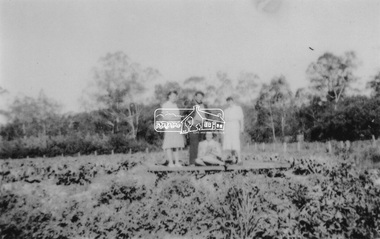
Photograph, At Bell Street, Eltham; from left: Helen Skipper, Matcham Skipper, Sonia Skipper and possibly Myra Skipper
At Bell Street, Fabbro Farm, Eltham; From left: Helen Skipper, Matcham Skipper, Sonia Skipper and possibly Myra Skipper, standing in the middle of a vegetable crop. The site of the Fabbro farm (Diamond Creek side land) is now called Barrack Bushlands. It is doubtful that Fabbro's farm holding was ever called Barrak Park, This title is fairly recent after the Shire of Eltham purchased the land, including the last section in 1993/94. About this time the area on the west side of Falkiner Street was purchased by a private developer and developed as housing. The area in Bell Street opposite the Eltham High School was purchased by the State Government is recent years and is called Fabbro Fields. The Fabbro Family operated their farm in Bell Street, Eltham. 1 black and white photographfabbro's farm, bell street, eltham, farming, helen skipper, vegetables, matchcam skipper, myra skipper, sonia skipper -
 Eltham District Historical Society Inc
Photograph, Fabbro's farm, Bell Street, Eltham, c.1990s
... farm 1 colour photograph printed with white border Fabbro's ...Fabbro's farm and house, Bell Street, Eltham, c.1990s. A crop of artichokes were planted on the farm at this time. The site of the Fabbro farm (Diamond Creek side land) is now called Barrack Bushlands. It is doubtful that Fabbro's farm holding was ever called Barrak Park, This title is fairly recent after the Shire of Eltham purchased the land, including the last section in 1993/94. About this time the area on the west side of Falkiner Street was purchased by a private developer and developed as housing. The area in Bell Street opposite the Eltham High School was purchased by the State Government is recent years and is called Fabbro Fields. The Fabbro Family operated their farm in Bell Street, Eltham. 1 colour photograph printed with white borderfabbro's farm, bell street, eltham, artichokes, barak farm -
 Eltham District Historical Society Inc
Photograph, Artichokes growing at Bell Street, Eltham, c.1990s
Fabbro's farm and house, Bell Street, Eltham, c.1990s. A crop of artichokes were planted on the farm at this time. The site of the Fabbro farm (Diamond Creek side land) is now called Barrack Bushlands. It is doubtful that Fabbro's farm holding was ever called Barrak Park, This title is fairly recent after the Shire of Eltham purchased the land, including the last section in 1993/94. About this time the area on the west side of Falkiner Street was purchased by a private developer and developed as housing. The area in Bell Street opposite the Eltham High School was purchased by the State Government is recent years and is called Fabbro Fields. The Fabbro Family operated their farm in Bell Street, Eltham. 1 colour photograph printed with white borderfabbro's farm, bell street, eltham, artichokes, barak farm -
 Eltham District Historical Society Inc
Photograph, Maurice Fabbro with artichokes growing at Bell Street, Eltham, c.1990s. Maurie is in his 70s
Fabbro's farm and house, Bell Street, Eltham, c.1990s. A crop of artichokes were planted on the farm at this time. The site of the Fabbro farm (Diamond Creek side land) is now called Barrack Bushlands. It is doubtful that Fabbro's farm holding was ever called Barrak Park, This title is fairly recent after the Shire of Eltham purchased the land, including the last section in 1993/94. About this time the area on the west side of Falkiner Street was purchased by a private developer and developed as housing. The area in Bell Street opposite the Eltham High School was purchased by the State Government is recent years and is called Fabbro Fields. The Fabbro Family operated their farm in Bell Street, Eltham. 1 colour photograph printed with white borderfabbro's farm, bell street, eltham, artichokes, barak farm, maurice fabbro -
 Kiewa Valley Historical Society
Book - Country Women's Association of Victoria, Victoria C.W.A. / For Country and City Women
Historical: This book covers all aspects of the C.W.A. including its history. The Tawonga branch of the C.W.A. commenced on the 7th Feb. 1946 and often combined activities with the other branches in the Kiewa Valley. The C.W.A. aimed to improve health, welfare and education for women and children in the country .Women living in Tawonga were mostly on farms and, in 1946, when the branch commenced, would have been feeling more remote with WW11 having had an effect on available workers and the well being of the women and children.Small 17 page book with white cardboard cover and green writing. Pages are held together with 2 staples. Cover: "The Country Women's Association / of Victoria Inc. / For Country and City Women / Victoria (with logo underneath) Address and contact details beneathcountry women's association of victoria. c.w.a.. tawonga. -
 Kiewa Valley Historical Society
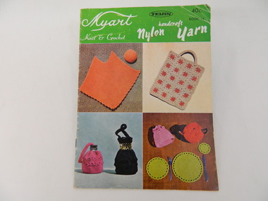
Book - Country Women's Association of Victoria, Myart Knit & Crochet
This book was used by members of the Tawonga C.W.A.. The group exhibited their handicrafts and made items for charity. The Tawonga branch of the C.W.A. commenced on the 7th Feb. 1946 and often combined activities with the other branches in the Kiewa Valley. The C.W.A. aimed to improve health, welfare and education for women and children in the country.Women living in Tawonga were mostly on farms and, in 1946, when the branch commenced would have been feeling more remote with WW11 having had an effect on available workers and the well being of the women and children.Small coloured 16 page book with a cover showing 4 squares of knitted and crocheted items. At the top the book has a light green background with white writing and some black writing. The back cover is similar with 4 different items. The book is bound with 2 staples. The book has patterns with instructions for knitted & crocheted items.Cover: 'Myart / Knit & Crochet' - on left. 'Handcraft / Nylon Yarn' - on right. 'Teijin 40c / Book 14' - top right in blackcountry women's association of victoria. tawonga. handcrafts. knitting. crocheting. -
 Kiewa Valley Historical Society
Book - Craft, Dressmaking Made Easy, 1958
Tawonga C.W.A. was involved in dressmaking and other home industries.The Tawonga branch of the C.W.A. commenced on the 7th Feb. 1946 and often combined activities with the other branches in the Kiewa Valley. The C.W.A. aimed to improve health, welfare and education for women and children in the country. This was achieved by getting together and exchanging ideas on dressmaking while providing for their families and the local community, possibly selling their products at fetes.Women living in Tawonga were mostly on farms and, in 1946, when the branch commenced would have been feeling more remote with WW11 having an effect on available workers and the well being of the women and children.Small white and grey book with picture of tape measure and cotton reel on the cover. It has 15 pages including the cover which is printed on too. It has general instructions for sewing. Held by 2 staplesCover: Woman's Realm presents / Dressmaking / made easy / Simple instructions and / step-by-step diagrams for / making your own clothes tawonga. country woman's association of victoria. dressmaking. woman's realm. c.w.a. -
 Kiewa Valley Historical Society
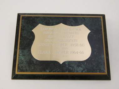
Plaque - Country Women's Association of Victoria, Tawonga Branch of the C.W.A, 1960's
The Tawonga branch of the C.W.A. commenced on the 7th Feb. 1946 and often combined activities with the other branches in the Kiewa Valley. The C.W.A. aimed to improve health, welfare and education for women and children in the country. The Roper family were very involved for many years in the activities of the branch. Clare Roper collected and documented the history of the Tawonga C.W.A. and the Kiewa Valley C.W.A.. Women living in Tawonga were mostly on farms and, in 1946, when the branch commenced would have been feeling more remote with WW11 having had an effect of available workers and the well being of the women and children.Black wooden plaque sloped to a narrow gold coloured border surrounding a black surface with a gold badge shaped plaque. The plaque has writing etched into it and painted white.Tawonga Branch C.W.A. / honours its Members / Kiewa Valley / Group Presidents / Annie V. Roper 1958 - 60 / (Mrs Bert) / Clara J. Roper 1964 - 66 / (Mrs Jack)tawonga. country woman's association of victoria. clara roper. annie roper. -
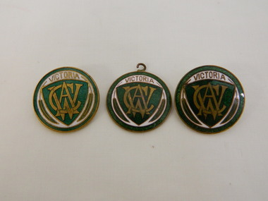 Kiewa Valley Historical Society
Badge - Country Women's Association of Victoria. x3
The Tawonga branch of the C.W.A. commenced on the 7th Feb. 1946 and often combined activities with the other branches in the Kiewa Valley. The C.W.A. aimed to improve health, welfare and education for women and children in the country. Women living in Tawonga were mostly on farms and, in 1946, when the branch commenced would have been feeling more remote with WW11 having an effect on available workers and the well being of the women and children.Round green and white badge with the CWA logo in the centre of a green triangular shield. The logo is in gold. Around the triangular shape it is white with Victoria in gold at the top and 2 slim leaves on each side of the other sides. The badge has a green border. The back is gold and two of them have a pin attached. The third has a ring attached at the top. On the back each one has a different inscription and all are hard to read. Each badge is very slightly different in texture and depth of colour perhaps indicating that they were made at different times."Victoria / CWA" On the back - 1. Inscribed in oval shape 'Morgan Swann' but upside down to each other. 2. Inscribed - 'Stoker' 3. Inscribed - 'Stokes' or 'Stones'tawonga. country woman's association of victoria. badge. cwa logo. -
 Kiewa Valley Historical Society
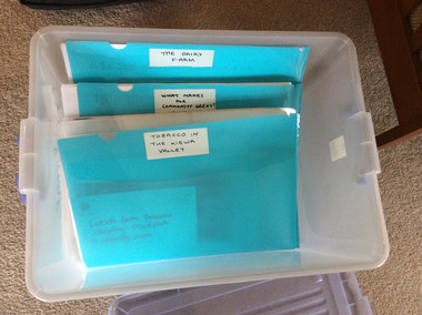
Folders - Exhibitions in the KVHS Museum
The KVHS rotates its displays in the Mt Beauty Museum. These topics are researched and give a deeper insight into the chosen topic.A frosted white plastic tub holding blue plastic folders each with information and photos of each of the temporary displays that the KVHS has displayed in the Mt Beauty Museum. These include: 1. And Then There was Light 2. A Woman's Work is Never Done 3. Bogong Village - Camps 4. Cross Country Skiing 5. Electricity: Watts the Story 6. Here Comes the Bride 7. High Country Cattlemen 8. Indigenous People 9. Mt Beauty - Early; 10. Mt Beauty Sports 11. Not All Tea and Scones - C.W.A.12. Old School Days 13. Tawonga District General Hospital 14. The Buffalo Lodge 15. The Dairy Farm 16. Tobacco in the Kiewa Valley 17. What Makes our Community Great? Clubslight, women's work, bogong village, cross country skiing, electricity, weddings, cattlemen on the high plains, indigenous australians, mt beauty, c.w.a., schools, tawonga hospital, buffalo lodge, dairy farming, tobacco in the kiewa valley, community clubs -
 Kiewa Valley Historical Society
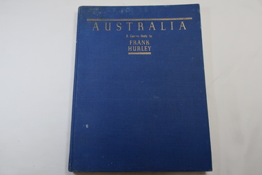
Book - Book- Photos, Australia - A Camera Study by / Frank / Hurley
Frank Hurley (1885-1962) was an Australian photographer and adventurer. He participated in trips to Antartica and was an official photographer with the Australian forces during both world wars. This book was first published in 1955.Photographs include the Hume Reservoir, Mt Buffalo and the Alpine High Country of Mt Kosciusko. (pages 140-144) All are associated with the type of country at each end of the Kiewa River. The Kiewa River flows into the Murray River just below the Hume Dam and Mt Buffalo and Mt Kosciusko are part of the Alpine High country near the Bogong High Plains. Clare Roper lived on a farm in the Kiewa Valley.Blue hard cover, bound book with the title in gold at the top. 208 pages. Mostly Black & white photos but some coloured.Inside back of first page - written 'Clare Roper'frank hurley photographer, australian photography, clare roper -
 Kiewa Valley Historical Society
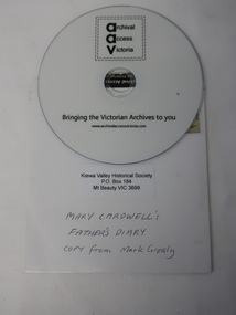
DVD - Mary Cardwell's Father's Diary
Dairy farmers kept a journal to record their transactions and business on the farm. John Creamer' daughter, Mary Cardwell has her father's journal covering the years 1916 to 1942. Mark Grealy digitised the journal for KVHS to preserve the contents and to make it available to the public at the PRO as an item of significance. DVDs have been replaced by USB sticks as technology advances.The journal was kept by local dairy farmer John Creamer, who farmed at Gundowring in the Kiewa Valley. It consists of names of local people and is representative of the business (produce and life) on the dairy farm at the time. DVDs are a digitised version of the Journal and require a computer to be able to play it as technology advances.DVD is white with black print:on the front: 'AAV' / 'Archival Access Victoria / Bringing the Victorian Archives to you / www.archivalaccessvictoria.com. The DVD is in a white cardboard sleeve with a postage stamp, KVHS address and Title: 'Mary Cardwell's / Father's Diary / Copy from Mark Grealy' Ref: KVHS 0947As Above. dairy industry, creamer family, gundowring, dvd dairy farm journal -
 Kiewa Valley Historical Society
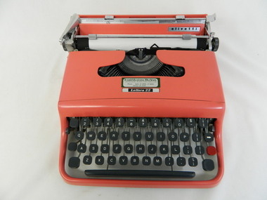
Typewriter Mechanical Portable, 1950s
The Olivetti company was founded in Italy in 1908.This particular typewriter is a Olivetti Lettera 22, oblique front stroke and portable manufactured after 1950. The 1950s and 1960s was a time when British manufactured goods were still purchased by many Australian consumers. The later 1960s onwards, there was a shift, mainly in the cities, to European made goods. The invasion of Japanese manufactured goods was relatively slower, especially in rural areas. The demand for long lasted and dependable merchandise was in the rural area still the most important criteria. The ease of setting up this typewriter and its compact mobility was its major benefit to trades people and travelling professionals, e.g. rural doctors, other medical professionals, accountants, lawyers and educators. This item facilitated the growing numbers of professional nomads requiring a relatively light office stationery package e.g. travelling novelist, writer, businessman and academics. This typewriter needed no electrical or battery power to operate it. Outback Australia, where at this point in time, was still relatively isolated from a good available electrical power reticulation and battery power, and therefore could not be totally measured as a highly efficient office environment.Although this typewriter was purchased from a business in Penrith, Sydney, N.S.W., it is significant that it travelled easily to the Kiewa Valley, demonstrating the mobility of certain sections of the community. This typewriter was designed by an Italian industrial designer, Marcello Nizzoli, in line with the art deco style of the 1930s and the colour and flexibility of the vibrant 1950s. The underlying theme of manufacturing in the 1950s was to produce equipment that was more efficient than what was inherited from the earlier period of 20th century. Improvements were made to this Olivetti typewriter by Giuseppe Beccio by reducing the number of parts made from 3,000 to 2,000. This reduction of parts and therefore cost of production was the major principle of the Japanese manufacturing juggernauts of the post World War II era. Efficiency and low costs material was becoming prime factors in the success of rural industries from the 1960s. Competition from overseas producers was starting to affect rural industries and the removal of the large range of tariff protection, especially rural products, required not only a shift of farm management but a more efficient cost savings modus operandi. This Olivetti Lettera 22, oblique front stroke portable (weighs 4kg) mechanical typewriter has a coral coloured plastic casing. The keys are made of black hardened plastic with white lettering, numbers and symbols (imperial fractions, and pound). It has a QWERTY keyboard as opposed to the Italian QZERTY. It has a lever to move the ribbon between black, neutral (for mimeograph stencils)and red colours (a red key is provided for highlighting specific words,letters or symbols) . This machine is fitted with only a black ribbon. It has a black rubber paper rollers and chromed metal parts on the carriage way. It has four rubber feet underneath the main body. On the left side of the roller there is a lever to adjust the roller from fixed (when mobile) through 1,2 and 3 line space gradients. This model has a key for zero but not one for the number one (uppercase letter l is used) see KVHS 0459 for the carrying bag.On the cover over the ribbon wheels letter strikers has a plate marked "Lettera 22" and the back plate behind the paper roller and in front of the paper supports has a silver metal label marked "olivetti made in great britain".commercial, mobile office equipment, mechanical typewriter -
 Kiewa Valley Historical Society
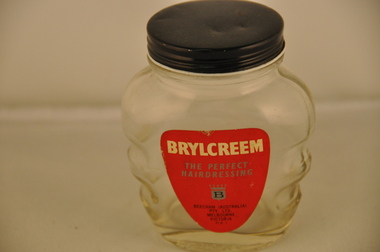
Jar Brylcream- Personal Item, Circa mid 1900s
This product was introduced in an era where the "silky smooth" look was in vogue. From the 1920s on, American and British film stars set the tone of how clean cut (hero type) masculine look attracts the opposite sex faster and in greater quantities than the "unkempt" or natural maintained look. This look was bold and "polished" and had the intended projection that the hair matched the character of "I look after myself and have a high opinion of physical appearances". As fashion goes this slick and well maintained look has circled many times, in and out of history and in Australia in the 1950s this was a prime example. The liberation of the stereo type of both sexes occurred in the 1960s when the freedom loving "hippie culture" had a marked affect upon the city inhabitants but not so strong among rural males. Sexism was still rife in that time frame.This jar of Brylcreem was a part of the (masculine) rural scene for a longer period than that found in the larger towns and cities. The long held "men are men" and "women are women" distinction between the sexes lingered on more in rural areas because of the perceived physical differences, mainly "strength" and perceived tasks such as "men only" activities (heavy farm/mining/construction). The jar of Brylcreem maintained the respectable male look for those special occasions when males "dressed" up and looked clean physically and well behaved (to show respect to the women folk)This glass jar with a glued on,red background, label detailing the product Brylcreem (a men's) hairdressing ointment is empty of its original product. It has been contoured on each side to allow for a man's fingers to comfortably and firmly grip the jar. This form would allow even "greased up" hands to maintain control. The glass thickness is far greater than needed and also added the extra stability to the standing jar. The shape of the jar is a latent attempt to emulate the physique of a fit young man (small waist, expanded and muscled mid rift and large shoulders). The jar does not distract from viewing its contents (clear glass). It has a black gloss screw (on/off) lid made from mild grade steel. The jar holds approximately 200 grams of a thick molasses textured product. On the front red Label; in large white letters "BRYLCREEM" underneath this is in smaller silver print "THE PERFECT HAIRDRESSING" underneath this is a banner type motif with a crown at the top and a black letter "B"in the centre. Below this and in much smaller print are printed in black script "BEECHAM (AUSTRALIA) PTY. LTD. MELBOURNE VICTORIA M A Imen's deportment, toiletries, men's hair styles, physical appearances -
 Eltham District Historical Society Inc
Photograph, Entrance to Shire of Eltham Memorial Park, Garden Hill, Eltham-Yarra Glen Road, Kangaroo Ground, c.1923
View to south-east from Shire of Eltham Soldiers' Memorial Park showing the carriageway from the road to top of Memorial Park. Accompanying notes state that the entry gate was put in place in May 1921. Eltham and Whittlesea Shire Advertiser and Diamond Creek Valley Advocate Fri 21 May 1920 p 2 reported: Kangaroo Ground Memorial Park "It was decided to arrange for a working bee on Saturday, 29th inst., for the purpose of forming and gravelling the track leading to the Park, and of carrying out other necessary works." A history summary of the Shire of Eltham Soldiers’ Memorial Park • The summit at Garden Hill was a popular tourist lookout and picnic spot from the 1880s. Virtually the entire Shire of Eltham and beyond could be viewed from this location. • A local farmer, Mr Walter A. D. Wippell is credited as being the first to propose the idea of a war memorial park and offered £50 towards the purchase of the land. • The earliest public reference to this project is to be found in the local Advertiser newspaper edition of August 9th, 1918. A report of the August Council meeting records the Eltham Shire President, Cr. Robert White, saying: "some time back it was proposed that the Council obtain and place on an Honour Board in the Council Chamber [at Kangaroo Ground] containing names of the lads who had enlisted. Just recently however, it had been suggested that a more fitting memorial would be the obtaining of a piece of land on the summit of Garden Hill, Kangaroo Ground, and the formation of a memorial park in which a monument could be erected to represent the whole of Shire. If a couple of acres could be obtained a gentleman had promised to donate 50 pounds, and another one would fence it, and other contributions, he was sure, could be obtained." • Councillors were favourable of the proposal and the President, Shire Secretary and Shire Engineer were deputised to wait on Messrs Mess Bros. (the owners of the Garden Hill farm) and ascertain if they would gratuitously give the land. The Mess Bros. land adjoined the farm/stud of Mrs Fanny White (Cr Robert White’s mother), daughter of Andrew Harkness who established their property on Garden Hill around 1846. • Access to the land came in February 1919 when several Councillors and the Shire Engineer surveyed the actual two acres of '5 chains along the road and 4 chains deep'. The Engineer volunteered his services free to do this task. The Mess brothers however demanded £100 per acre but eventually agreed to take £50 per acre. • Entry from the Kangaroo Ground-Yarra Glen road was seen to be a problem and Mrs. White, who owned the land beside the park, was asked to donated a triangle of her property to allow this access. • By September 1919 returned soldiers were employed by the Shire and volunteers were called to clear the hilltop by ploughing up the rocks and clearing the area, the fencing was put into place and in May 1921 the Council erected three gates, within an archway, at the entrance to the drive and pathway to the summit. • Public subscriptions were sought through the Advertiser newspaper to beautify the site. The views of the Curator of the Melbourne Botanical Gardens were sought as to the ‘class of ornamental trees most suitable for planting in the Park area”. • The Memorial Park or Shire of Eltham Soldiers’ Memorial Park was officially opened by Mr. W.H. Everard, M.L.A., 3 September 1921. • In 1922 plans were made to place a War Memorial in the Park. Funds were donated by the Council of £250 and a challenge to the community, to match this money with contributions was met. • On Anzac Day 1923, 1,000 people gathered on the summit in the park for a memorial service. A much smaller group of about 50 people gathered around a newly constructed cairn and flagstaff in the afternoon of Anzac Day 1924 amidst rain and a squally southerly wind, the morning service being cancelled. • A meeting for those interested in establishing a War Memorial monument within the park was held in January 1924 and the Eltham Shire War Memorial League was formed and a design competition decided upon. • The Shire of Eltham War Memorial tower was built in 1926 at a cost of £1,023 and 5 shillings with locally quarried stone donated by Dr Ethel and Professor William Osborne. It was formally known as the ‘Shire of Eltham War Memorial’ and was unveiled on 11 November 1926. The large bronze inscription above the entrance to the tower states: SHIRE OF ELTHAM WAR MEMORIAL THESE MEN DIED FOR THEIR COUNTRY 1914 IN REMEMBRANCE THIS TOWER WAS BUILT 1918 • The Caretaker’s hut was built in 1927 with left over from the tower construction. • A returned soldier was appointed to act as caretaker for the memorials. Tiny Carrol, a huge man, was the first caretaker and lived in the stone hut. There was a push to have alterations made at one stage to provide additional rooms for a married caretaker but was rejected. • A new Caretaker Cottage was built in 1951 at a cost £2,500. The cottage had been subjected to raids by thieves three times during construction until a guard from the Returned Servicemen’s League was posted until its opening. • The War Memorial tower was re-dedicated by Sir Dallas Brooks on 8 November 1951, unveiling new bronze plaques containing the names of those who fell during the Second World War. Sir Dallas also officiated the opening of the new Caretaker’s Cottage. • A toilet block was built in 1965. • A further dedication of the Shire of Eltham War Memorial tower took place 11 November 2001 to recognise the men who fell in subsequent campaigns up to and including Vietnam. • Four land titles are involved: o The purchase of the two acres from owners Ruth Gosling, Alexander Mess, James Johnson Mess and Joseph Mess is recorded in two actions, the first being the payment of £100 for the two acres, the second showing that the Shire of Eltham did not get a transfer of title until 14th January 1952. o The access land donated by Mrs. Fanny White is dated 26 February 1924. A further need to widen the entry came after the deepening of the road cutting and another land donation was given by Sir Herbert Gepp, title dated 15th May 1952. This would have been about the time he sold off the former White ‘Garden Hill’ property. o The land reserve to increase the area and possibly allow a circuit road to be put in place on the western side of the park was purchased by the Shire of Eltham, title dated 16th February 1973. Rare photograph of the entrance to the Shire's Memorial Park during early stages of development prior to the erection of the Shire of Eltham War MemorialSepia photograph printed with white border with slight crack lower left hand corner and three significant vertical cracks fanning from lower centre edge to upper edge Digitally enhanced version to minimise impact of crackseltham-yarra glen road, entrance gate, garden hill, kangaroo ground, shire of eltham memorial park, shire of eltham war memorial, kangaroo ground war memorial park -
 Eltham District Historical Society Inc
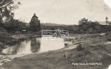
Photograph - Photo Postcard, Pond near Eltham Park, c.1910
This card depicts the pond near Eltham Park (later Eltham Lower Park) circa 1910. The view is taken from Maria Street (Main Road) opposite Dalton Street looking northwest across the Dalton Street road extension reserve (now Wingrove Park Trail) and Jarrold farm. A haystack is visible. Also visible is a gas streetlight and White Cloud cottage which belonged to the Jarrold family From the same collection as accession no. 00778, (Yarra at Eltham) - sent from Eltham and addressed to "Mr J. L. Brown, "Elthamville", Tinning Street, Brunswick" "with love from Nellie" who was most probably a member of the extended Brown family, and no. 00780 (Eltham, J.H. Clark Photo - dated 20 May 1911). Sending postcards to family and friends including short messages was a common form of communication in the early 20th century. Part of a slide show presentation "Bridges & Waterways of the Shire" by Russell Yeoman to the 13 September 1989 Society meeting. The presentation included slides of historic photos from the Shire of Eltham Pioneers collections as well as several recent views.Sending postcards to family and friends including short messages was a common form of communication in the early 20th century.Sepia postcard in very poor condition which has been removed from an album. Glue residue and album page adhering preventing information being readFront: Pond near Eltham Parkpostcard, eltham, pond, dalton street, duck pond, eltham park, elthamville, gas lamp, haystack, jarrold cottage, jarrold property, main road, maria street, white cloud cottage, wingrove park trail -
 Eltham District Historical Society Inc
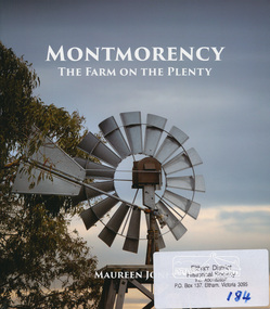
Book, Montmorency: The Farm on the Plenty by Maureen Jones, 2015
This book lays out the history of Montmorency from its earliest years as a hunting ground the Wurundjeri willam people, through its uptake by white settlers. Ownership of the land remained in the hands of one family for four generations spanning seventy years, before the land evolved through small farmlets into a suburb once part of the former Shire of Eltham, now part of Banyule City Council.Little has been written on the history of this hidden suburb of Melbourne. This book is significant in that it is the first major local history publication devoted to the suburb gathered particularly from local historical society archives and oral histories. ISBN 9780980807912montmorency -
 Eltham District Historical Society Inc
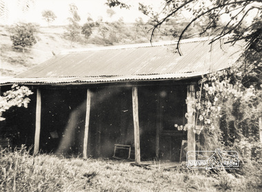
Photograph, Old farm building
Colour photograph of black and white original (behind glass) of old farm building, location unknown (reflections evident)buildings, sheds, farming -
 Warrnambool and District Historical Society Inc.
Medal, Campaign Stars & Medals, C 1945
This medal was awarded to Ernest Henry Swan. He served from December 1941 to July 1942 in the Citizen Military Forces and from July 1942 to September 1944 in the Australian Imperial Forces. His reason for discharge was reserved occupation. He held the rank of corporal in 26th Motor regiment. He was born in Colac 19/11/1919 to Ernest Swan and Daisy Johnson. He died 04/08/2009 and is buried at the Warrnambool cemetery. During his life he farmed a soldiers’ settlers block in the Grasmere area, north of Warrnambool.A common item which relates to a local soldier and World War 11.Round white metal medal with bar at top. Australian Coat of arms on front with image of George 6th on the reverse. Flat edge on medal with recipient's name and number engraved. it is housed in small cream card box with a small sheet of paper with summary of conditions of campaign stars and medals. The Australian Service medal 1939-1945. George VI G Br OMN Rex Et Indiae Imp VX88010 E H Swanwarrnambool, ernest henry swan -
 Warrnambool and District Historical Society Inc.
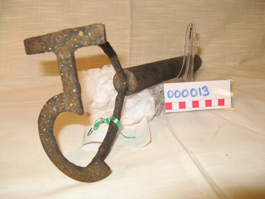
Functional object - Farming Equipment Branding Iron, Circa 1840
Armyne, George and Lemuel Bolden were original landholders of large parts of land in the Western district. Portions of it extended from Pirron Yallock in the East to almost as far as Portland. The head station was at Grasmere. They were noted breeders of shorthorn cattle in fact they were some of the first men to bring the breed to Victoria and thus helped to pioneer the Australian Shorthorn breeding Industry. This branding iron was found at Lyall Park, originally 640 acres selected by William Lyall at Cooramook. It is believed to be a branding iron dating from when the land was occupied by the Bolden Brothers. The Bolden Brothers were the first to erect considerable lengths of fencing in the Warrnambool area. If this item is an authentic Bolden piece of property then it is the oldest artefact from the time of white settlement that is held by the Warrnambool and district Historical society. The item itself while a common farming implement and which was found on a farm originally owned by the Bolden Brothers is a link with the earliest part of Warrnambool’s history.Short, round wooden handle with metal brand in the shape of the letter T with two thirds circle attached to vertical part of T. Daub of paint at end of handle . T 5Paper label attached with green tape with 931 in texta and hand written on back,” branding iron reputed to have been used by Bolden Bros Grasmere c 1840. warrnambool, bolden brothers, armyne bolden, george bolden, lemuel bolden, branding iron, shorthorn cattle -
 Orbost & District Historical Society
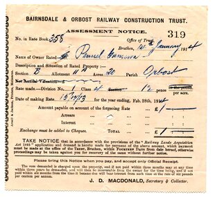
assessment notices, 1913 1914 1926
In the Orbost area a committee was formed called the Bairnsdale to Orbost Railway Trust. The business of the trust was to acquire the land necessary for the railway and levy a rate on the property owners. The other cost to the area wanting a railway was the guarantee against loss in working expenses of the railway, the Orbost Shire had to provide up to £3000 per annum. Even as late as 1913 the railway was still expected to go through Orbost and beyond. 635.3 is to Albert Trewin for 158 acres at Orbost. 635.2 is to Robert P. Cameron for 120 acres in Orbost and 635.1 is for Penuel Cameron for 20 acres in Orbost. Robert Pullar Cameron was a Shire Councillor for many years. He married Penuel Hossack and had a family of James, Flora, Penuel and Alex. Albert and Hazel Trewin farmed at Jarrahmond, just outside Orbost on the B Road. This item is associated with the history of the Orbost-Bairnsdale railway line and therefore reflects the role that the rail line played in the social and economic history of Orbost.Three paper notices of assessment. 635.1 is white with black print. 635.2 and 635.3 are pink with black print. All have hand-written details. They are from the Bairnsdale and Orbost Railway Trust.orbost-bairnsdale-railway cameron-robert-pullar trewin-albert assessment-notices -
 Orbost & District Historical Society
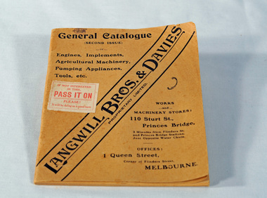
catalogue, Fraser & Jenkinson, Langwill Bros & Davies Pty Ltd, early 20th century
Langwill Bros & Davies of Melbourne were agents for imported farm pump engines, windmills and other farm implements.. Because of war shortages, they started building the engines themselves under the Challenge brand in 1916. "..with the exception of the magneto, every part of the engine is manufactured in Australia from Australian raw material." They also sold imported Challenge windmills.This item is associated with the history of agriculture in early Orbost and is a useful research tool.A small light brown covered catalogue which has "Langwill Bros. & Davies Pty Ltd" diagonally across front in black print, items on offer and details of the company. There is a white stamp on the front with red print - "If you're not interested in this; PASS IT ON; Please; It will be doing us a good turn".catalogue farm-machinery langwill-davies -
 Orbost & District Historical Society
newspaper clippings, February 1971
These articles were compiled by Mary Gilbert who was the first curator of the Orbost Museum and a prominent historian / teacher in Orbost. The 1971 floods at Orbost were the worst on record. At Jarrahmond the river rose to a height of 11 metres and on the flats spread to one and a half kilometres wide. Considerable damage was done to railway infrastructure, roads and farms. More information from the APRIL, 2008 newsletter by John Phillips. (see orbosthistory.com.au)These articles are contemporary records of a significant historical event in Orbost.A manila folder containing black / white newspaper clippings from various publishers. They all relate to the 1971 floods in Orbost. (Details of contents in catalogue 735-900)floods-orbost-1971 -
 Orbost & District Historical Society
Painting - framed, second half 19th century 1860's?
James came to Australia from Plymouth on the ship "Mobile" arriving 16/11/1853 aged 22. he married Alice Roberts on November 27, 1861. With a large young family he moved from Central Victoria to Glengarry in Gippsland where he farmed and set up sawmills at Glengarry and Rosedale. After hearing of land grants at Orbost and investigating the possibilities with Elizabeth, his eldest daughter he selected land at Pumpkin Point, Bete Bolong. The whole family (ten children from 23years - 2years) eventually moved to Orbost around 1885. ( read "From White Knowle to Pumpkin Point" by Hon Peter Nixon A.O.) He had the first saw mill. He convened the meeting that established butter factory foundation and shares and was the first Agricultural Show president,James Nixon was a significant and influential citizen of Orbost's early years.Portrait done in oils of Nixon, James Mr. The portrait is of the bust of Nixon in a tuxedo with blue to grey background. Timber finish frame.nixon-james orbost-bete-bolong pumpkin-point -
 Orbost & District Historical Society
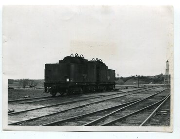
black and white photographs, second half 20th century
3151.1 is of a water tanker on stand by at Orbost ready for emergency use. Similar suppliers were at Bairnsdale and Nowa Nowa. The two tankers hels about 9,000 gallons (34068.7 litres) - from a news item in "Gippsland" September, 1971. 3151.2 is of Victoria's X class 1,800 H.P general purpose diesel electric locomotive. Si had been ordered for the Victorian Railways and cost about £ 250,000 each. 3151.3 is of several loaded, covered railway trucks on a rail line. 3151.4 was taken at the goods yard at Orbost Railway Station. 3151.5 has some rail wagons with "SHOWMOBILE COUNCIL OF ADULT EDUCATION" on the sides. 3151.6 is of goods wagons (Probably not at Orbost Station) 3151.7 is a goods train 3151.8 shows the loading or unloading of farm produce at Orbost railway Station. 3151.9 shows cattle being loaded at Orbost Railway Station. 3151.10 is of a container N.Y.K. LINE ( a Japanese shipping company) This item is associated with the history of the Orbost-Bairnsdale railway line and therefore reflects the role that the rail line played in the social and economic history of Orbost.Ten black / white photographs related to Orbost rail. orbost-railway east-gippsland-railway transport-railway railway-engine orbost-railway-station export-produce -
 Orbost & District Historical Society
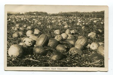
black and white photograph / postcard, first half 20th century
Pumpkins were grown widely on Orbost farms and used to feed pigsThis photograph is associated with pumpkin growing in Orbost.A black / white photograph / postcard of a paddock of pumpkins.on front- at bottom - "Orbost, East Gippsland"orbost-agriculture pumpkins-orbost -
 Orbost & District Historical Society
black and white photograph, February 1971
This photograph was taken near the Snowy River Bridge on the the old Princes Highway in Orbost, near the caravan park. The 1971 flood was the the worst flood on record. At Jarrahmond it was at least 11 metres and up to one and a half kilometres wide on the flats causing enormous damage to the flood plain. Records say that "The brown floodwater stain in Bass Strait could be seen from passing airliners." Considerable damage was done to railway infrastructure, roads and farms. More information from the APRIL, 2008 newsletter by John Phillips. (see orbosthistory.com.au)This is pictorial evidence of a significant local event. Floods have been an integral part of Orbost's history for hundreds of years.A black / white photograph of debris, fallen power lines, a tree across the highway and floodwaters across the road.on front at bottom - handwritten in upper case print - " 1971 FLOOD PRINCES HIGHWAY NEAR SNOWY BRIDGE"floods-orbost-1971 -
 Orbost & District Historical Society
black and white photograph, February 1971
This photograph is an aerial view of the township of Orbost taken by the Bairnsdale Advertiser newspaper. It was taken from the northern end of the town. The 1971 flood was the the worst flood on record. At Jarrahmond it was at least 11 metres and up to one and a half kilometres wide on the flats causing enormous damage to the flood plain. Records say that "The brown floodwater stain in Bass Strait could be seen from passing airliners." Considerable damage was done to railway infrastructure, roads and farms. More information from the APRIL, 2008 newsletter by John Phillips. (see orbosthistory.com.au)This is a pictorial record of a significant event in the history of Orbost,A black / white aerial photograph of a township with floodwaters in the background.on back - "Note main current through the lagoon 1971."orbost-floods-1971 bairnsdale-advertiser orbost-township -
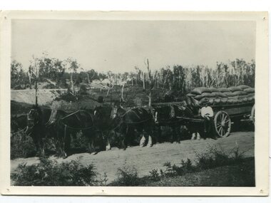 Orbost & District Historical Society
black and white photograph, late 19th century
This is a photograph of Dave Hawkless at Bete Bolong with a wagon load of maize from the farm of Sam Lynn. David Hawkless was married to Mary Downey in 1906. They had five children. This is a pictorial record of the transporting of maize in the Orbost district in the late 19th century. A black / white photograph of a man standing in front of a wagon loaded with sacks. There are six large horses tethered to the wagon. In the background are buildings. The wagon is standing on a gravel road.on back - "D. Hawkless M. Gilbert"hawkless-david maize-orbost transportation-agriculture wagon-horses