Showing 1694 items
matching town centre
-
 Kiewa Valley Historical Society
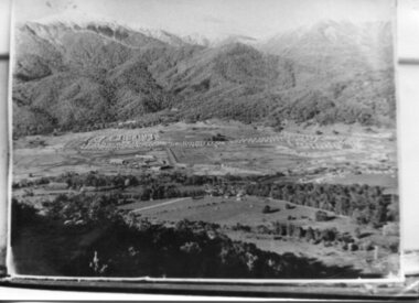
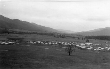
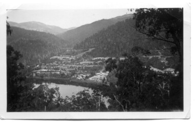
Photograph - Mt Beauty Camp, Estimated 1950-1951
This photo is of the very newly constructed State Electricity Commission town of Mt. Beauty. The houses up to Nelse street were erected from 1946 onward and then the township was extended beyond Nelse Street in 1950 which places this photograph about 1950/51. There is no evidence of work being commenced on the regulating pondage but the tail race canal can be seen on the centre right of photo. The workmen's camp was enlarged in 1950 to the extent of providing accommodation for a total of 1,200. There are a number of dwellings on Simmonds Creek and the road to Falls Creek can clearly be seen. Snow capped Mt. Bogong is in the upper left of the photo with Mt. Beauty behind the township rising to Big Hill beyond that.Shows the newly constructed town of Mt. Beauty surrounded by farmland and before the regulating pondage was built to discharge water from the power stations via the West Kiewa tail race tunnel into the Kiewa River. Copy of black and white photograph of Mt Beauty CampWritten on the back in black ink - A Campenmt beauty camp, secv, construction town -
 Kiewa Valley Historical Society
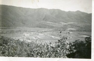
Photograph - Mount Beauty from Bogong Hill, 1950
The new State Electricity Commission construction camp at the head of the Kiewa Valley was for workmen on the second power station in the project expected to be the most modern and best equipped in Australia… In contrast to the early Kiewa days of horses and canvas tents, the new camp, with its modern amenities, compared favourably with any country town. Administration of the Kiewa Scheme was moved from Tawonga to Mount Beauty in 1946. The first house in Mount Beauty, in Hollonds Street, was occupied by the co-op store manager from November 1946. The new Mess Hall at Mt Beauty was opened with much ceremony in early November 1946. The houses up to Nelse street were erected from 1946 onward and then the township was extended beyond Nelse Street in 1950. The workmen's camp was enlarged in 1950 to the extent of providing accommodation for a total of 1,200.Shows early construction of the town of Mt. Beauty surrounded by farmland taken in 1950 during the early stages of construction of the Kiewa Hydro electric SystemBlack and white photograph - aerial view of Mt Beauty taken from Bogong Hill. Photograph framed by 6mm white boarder.Handwritten on back of photograph in black ink - Mt Beauty from Bogong Hill 1950 Printed on rear Volox 2428mt beauty, bogong hill, secv -
 Kiewa Valley Historical Society
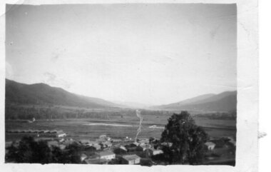
Photograph - Mount Beauty from second gate. View down Kiewa Valley, 1950
The new State Electricity Commission construction camp at the head of the Kiewa Valley was for workmen on the second power station in the project expected to be the most modern and best equipped in Australia… In contrast to the early Kiewa days of horses and canvas tents, the new camp, with its modern amenities, compared favourably with any country town. Administration of the Kiewa Scheme was moved from Tawonga to Mount Beauty in 1946. The first house in Mount Beauty, in Hollonds Street, was occupied by the co-op store manager from November 1946. The new Mess Hall at Mt Beauty was opened with much ceremony in early November 1946. The houses up to Nelse street were erected from 1946 onward and then the township was extended beyond Nelse Street in 1950. The workmen's camp was enlarged in 1950 to the extent of providing accommodation for a total of 1,200.Shows early construction of the town of Mt. Beauty surrounded by farmland taken in 1950 during the early stages of construction of the Kiewa Hydro electric SystemBlack and white photograph - View from second gate down Kiewa Valley showing early buildings. Photograph framed by 6mm white boarderHandwritten in back of photo in blue ink - View from second gate down Kiewa Valley 1950mt beauty, kiewa valley, secv -
 Kiewa Valley Historical Society
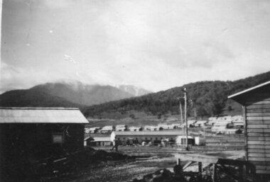
Photograph - Mount Beauty SEC Camp and Town, 1950
The new State Electricity Commission construction camp at the head of the Kiewa Valley was for workmen on the second power station in the project expected to be the most modern and best equipped in Australia… In contrast to the early Kiewa days of horses and canvas tents, the new camp, with its modern amenities, compared favourably with any country town. Administration of the Kiewa Scheme was moved from Tawonga to Mount Beauty in 1946. The first house in Mount Beauty, in Hollonds Street, was occupied by the co-op store manager from November 1946. The new Mess Hall at Mt Beauty was opened with much ceremony in early November 1946. The houses up to Nelse street were erected from 1946 onward and then the township was extended beyond Nelse Street in 1950. The workmen's camp was enlarged in 1950 to the extent of providing accommodation for a total of 1,200.Shows early construction in the town of Mt. Beauty surrounded by hills and farmland, with Mt Bogong in the background. Photo was taken in 1950 during the early stages of construction of the Kiewa Hydro electric SystemBlack and white photograph of Mt Beauty township in 1950 showing original workers buildings. Photograph has a .5cm white border around the photo.Handwritten on back of photograph in blue ink - SEC Camp and Town Mt Beauty 1950mt beauty, secv, mt beauty workmen's camp -
 Kiewa Valley Historical Society
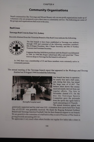
Photographs x 2 - 1. Mt Beauty Camp 2. Bogong Camp, Photo 1 - September 1950
Mt Beauty Camp- The new State Electricity Commission construction camp at the head of the Kiewa Valley was for workmen on the second power station in the project expected to be the most modern and best equipped in Australia… In contrast to the early Kiewa days of horses and canvas tents, the new camp, with its modern amenities, compared favourably with any country town. Administration of the Kiewa Scheme was moved from Tawonga to Mount Beauty in 1946. The first house in Mount Beauty, in Hollonds Street, was occupied by the co-op store manager from November 1946. The new Mess Hall at Mt Beauty was opened with much ceremony in early November 1946. The houses up to Nelse street were erected from 1946 onward and then the township was extended beyond Nelse Street in 1950. The workmen's camp was enlarged in 1950 to the extent of providing accommodation for a total of 1,200. Bogong Camp - In 1940 Field Headquarters for the Kiewa Scheme were established at Bogong with office, workshop facilities and accommodation for workmen, staff and some families constructed. (There had been a 'tent camp' on this site in 1939 but was destroyed by bushfires) Construction of accommodation continued until 1947. A total of 40 houses plus a hostel for single staff, post office, police station, medical centre and primary school all with water and sewerage and electricity supply. The staff hostel was known as Kiewa House and is now occupied by the Education Department. Lake Guy was named after Mr. L.T. Guy who was the Resident Engineer in charge of construction work and associated activities on the Kiewa area. He held this position from 1939 to November 1946 when he was transferred to Head Office. Both Bogong Village and Mt Beauty were developed to accommodate workmen on the Kiewa Hydro Electric Scheme but have since become centres for tourism and a range of outdoor activities.1. Black and white photograph of Mount Beauty Camp taken in September 1950 2. Black and white photograph of Bogong Village Camp1. Written on the back in grey lead - Sept 1950. Mt Beauty Camp. HT Cooper own taking 2. Stamped on back of photograph - Copyright. Not for reproduction. Herald Sun feature Service. Melbourne Australiamt beauty camp, bogong camp, secv -
 Kiewa Valley Historical Society
Photograph - Mt Beauty Camp
The new State Electricity Commission construction camp at the head of the Kiewa Valley was for workmen on the second power station in the project expected to be the most modern and best equipped in Australia… In contrast to the early Kiewa days of horses and canvas tents, the new camp, with its modern amenities, compared favourably with any country town. Administration of the Kiewa Scheme was moved from Tawonga to Mount Beauty in 1946. The first house in Mount Beauty, in Hollonds Street, was occupied by the co-op store manager from November 1946. The new Mess Hall at Mt Beauty was opened with much ceremony in early November 1946. The houses up to Nelse street were erected from 1946 onward and then the township was extended beyond Nelse Street in 1950. The workmen's camp was enlarged in 1950 to the extent of providing accommodation for a total of 1,200.Shows early construction in the town of Mt. Beauty surrounded by hills and farmland, with a snow capped Mt Bogong in the background. Photo was taken in approximately 1950 during the early stages of construction of the Kiewa Hydro-electric SystemBlack and white photograph, mounted on corrugated cardboard. Photograph of Mt Beauty townshipHandwritten on back of photograph in blue pen - Permanent loan from Adrian Campan April 96 057-544043mt beauty camp, secv -
 Kiewa Valley Historical Society
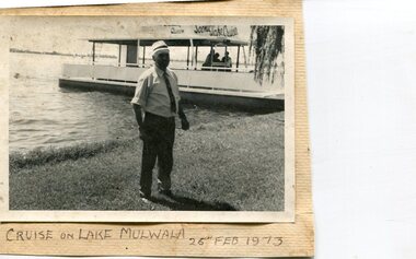
Photographs x 3- Cruise on Lake Mulwala, 25/2/1973
Lake Mulwala is a man–made reservoir created through the construction of the Yarrawonga Weir across the Murray River, is located between Bundalong and Yarrawonga in Hume region of Victoria and Mulwala in the Riverina region of New South Wales, in eastern Australia. The weir was constructed in 1939 to provide water for irrigation of the surrounding district. The weir also serves as a crossing of the Murray between the two towns. It is a popular tourist destination for boating, fishing and other water recreation.Photographs demonstrate local Kiewa Valley residents enjoying a visit to the picturesque area of Lake Mulwala. Also provides a pictorial history of 1973.3 black and white photographs mounted on buff card. Photographs of a cruise on Lake Mulwala 25th Feb. 1973 1. Photo of unidentified man standing on the shore of Lake Mulwala beside cruise launch. 2. Group photo of people standing by cruise boat as others disembark. Woman in centre holding handbag may be Clare Roper (unconfirmed) 3. Photo of 2 men aboard cruise launch looking out over Lake Mulwala1. Handwritten at bottom of photo in black ink. 'Cruise on Lake Mulwala. 25th Feb. 1973' 2. Painted sign above cruise launch- Scenic Lake Cruises 3. No markingsclare roper -
 Kiewa Valley Historical Society
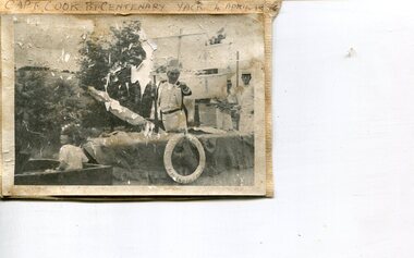
Set of 3 photographs= Captain Cook Bi-Centenery parade, 04/04/1970
The Captain Cook bicentenary was commemorated in Australia in 1970. The British explorer Lieutenant (later Captain) James Cook sailed and charted the East Coast of Australia in 1770, and claimed the Eastern Seabord of the Continent for the British Crown. This is not considered the official bicentenary of Australia, but rather the mapping of the Eastern coastlineLike many other towns around Eastern Australia, Yackandandah celebrated the bi centenary with a street parade, enjoyed by residents of surrounding areas including the Kiewa Valley3 black and white photographs mounted on buff card. Photographs taken at Captain Cook bi-centenary parade and celebrations in Yackandandah on April 4th 1970 1. Float depicting Captain Cook and sailors aboard the H. M. Endeavour 2. Local children on horseback possible representing the pony club. 3. Group of spectators standing outside the post office. One unidentified person dressed as a golliwogHandwritten in black ink above photo 1 "Capt. Cook Bi Centenary. Yack. 4 April 1970 (last number of date unclear) No marking on other photosyackandandah, parade, clare roper -
 Kiewa Valley Historical Society
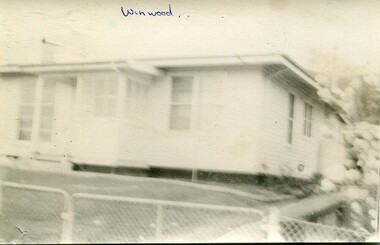
Photographs- Original S.E.C.V. home designs in Mt Beauty – Set of 6 black and white photographs
The townships of Mount Beauty and Bogong Village were constructed by the Victorian State Electricity Utility Commission (SEC) from the 1930’s to the 1950’s to house workers on the Kiewa Hydro Electric Scheme. At its peak the Kiewa Scheme employed around 4000 people. Although the towns were built as temporary accommodation for the workers and their families, many stayed and even retired there after the scheme had finished. The Bright Council, now the Alpine Shire took over the control of the township in 1960 and today Mount Beauty is one of the most complete company towns in Victoria.The SECV provided several standard designs for the housing of workers and management in Mt Beauty. At the completion of the scheme the housing was retained and Mount Beauty now exists as one of the best examples of a company town in Victoria.There are many examples of the original houses remaining around the town. This is significant as the houses were only built as temporary accommodation and still remain functional after over 60 or more years of use.Set of 6 black and white photographs of original SECV temporary house designs in Mt Beauty.Written in blue ink on front of photos 1. Winwood 2. Winwood 3. K Type 4. K Type 5. English Precut 6. Cube mt beauty houses, secv housing -
 Kiewa Valley Historical Society
Photographs – Kiewa Cres Mt Beauty. Circa 1993. Set of 12 colour photographs
... green space around the town centre. kiewa cres mt beauty mt ...Established in 1946, during the construction of the Kiewa Hydro Electric Scheme, the township of Mt Beauty was developed by the State Electricity Commission of Victoria to provide additional accommodation for the thousands of workers during the construction of the country’s second largest hydro-electricity scheme. Although these towns were built as temporary accommodation for the workers and their families, many stayed after the scheme finished. Combined with the influx of European migrants, with their rich cultural backgrounds, all played a major part in shaping the future character of the Mount Beauty, the Kiewa Valley and Falls Creek. The Bright Council, now the Alpine Shire took over the control of the township in 1960. This relatively young town of Mount Beauty, along with the surrounding townships of Falls Creek, Bogong, Tawonga South and Tawonga, are all part of a prospering tourist area with excellent services, accommodation, food and a wide range of recreational activities available for all ages. According to Shire records, the population of Mt Beauty has grown from 1,500 in 1981 to 1,800 in 2016 with a projected increase to 2,000 in 2013The photographs taken around 1993 show a prosperous commercial centre catering for both locals and the needs of visitors. It provides a pictorial history of the changes which have occurred in the retail/commercial district of Mt Beauty over the years. It also demonstrates the attention paid by Alpine Shire towards providing accessible recreational green space around the town centre.Set of 12 colour photographs of Kiewa Cres Mt Beauty. Circa 1993 showing retail services and streetscape of the time. No markingskiewa cres mt beauty, mt beauty -
 Kiewa Valley Historical Society
Photographs – Lakeside Avenue, Mt Beauty. Circa 1993. Set of 7 colour photographs
... green space around the town centre. Mt Beauty Lakeside Ave Mt ...Established in 1946, during the construction of the Kiewa Hydro Electric Scheme, the township of Mt Beauty was developed by the State Electricity Commission of Victoria to provide additional accommodation for the thousands of workers during the construction of the country’s second largest hydro-electricity scheme. Although these towns were built as temporary accommodation for the workers and their families, many stayed after the scheme finished. Combined with the influx of European migrants, with their rich cultural backgrounds, all played a major part in shaping the future character of the Mount Beauty, the Kiewa Valley and Falls Creek. The Bright Council, now the Alpine Shire took over the control of the township in 1960. This relatively young town of Mount Beauty, along with the surrounding townships of Falls Creek, Bogong, Tawonga South and Tawonga, are all part of a prospering tourist area with excellent services, accommodation, food and a wide range of recreational activities available for all ages. According to Shire records, the population of Mt Beauty has grown from 1,500 in 1981 to 1,800 in 2016 with a projected increase to 2,000 in 2013The photographs taken around 1993 show a prosperous commercial centre catering for both locals and the needs of visitors. It provides a pictorial history of the changes which have occurred in the retail/commercial district of Mt Beauty over the years. It also demonstrates the attention paid by Alpine Shire towards providing accessible recreational green space around the town centre.Set of 7 colour photographs of Lakeside Avenue, Mt Beauty. Circa 1993 showing retail services and streetscape of the time. No markingsmt beauty, lakeside ave mt beauty -
 Kiewa Valley Historical Society
Photographs – Tawonga Cres., Mt Beauty. Circa 1993. Set of 4 colour photographs
... green space around the town centre. Tawonga Cres Mt Beauty ...Established in 1946, during the construction of the Kiewa Hydro Electric Scheme, the township of Mt Beauty was developed by the State Electricity Commission of Victoria to provide additional accommodation for the thousands of workers during the construction of the country’s second largest hydro-electricity scheme. Although these towns were built as temporary accommodation for the workers and their families, many stayed after the scheme finished. Combined with the influx of European migrants, with their rich cultural backgrounds, all played a major part in shaping the future character of the Mount Beauty, the Kiewa Valley and Falls Creek. The Bright Council, now the Alpine Shire took over the control of the township in 1960. This relatively young town of Mount Beauty, along with the surrounding townships of Falls Creek, Bogong, Tawonga South and Tawonga, are all part of a prospering tourist area with excellent services, accommodation, food and a wide range of recreational activities available for all ages. According to Shire records, the population of Mt Beauty has grown from 1,500 in 1981 to 1,800 in 2016 with a projected increase to 2,000 in 2013The photographs taken around 1993 show a prosperous commercial centre catering for both locals and the needs of visitors. It provides a pictorial history of the changes which have occurred in the retail/commercial district of Mt Beauty over the years. It also demonstrates the attention paid by Alpine Shire towards providing accessible recreational green space around the town centre.Set of 4 colour photographs Tawonga Crescent, Mt Beauty. Circa 1993 showing retail services and streetscape of the time No markingstawonga cres mt beauty -
 Kiewa Valley Historical Society
Photographs – Holland Street North, Mt Beauty. Circa 1993. Set of 18 colour photographs
... green space around the town centre. Holland St Mt Beauty Mt ...Established in 1946, during the construction of the Kiewa Hydro Electric Scheme, the township of Mt Beauty was developed by the State Electricity Commission of Victoria to provide additional accommodation for the thousands of workers during the construction of the country’s second largest hydro-electricity scheme. Although these towns were built as temporary accommodation for the workers and their families, many stayed after the scheme finished. Combined with the influx of European migrants, with their rich cultural backgrounds, all played a major part in shaping the future character of the Mount Beauty, the Kiewa Valley and Falls Creek. The Bright Council, now the Alpine Shire took over the control of the township in 1960. This relatively young town of Mount Beauty, along with the surrounding townships of Falls Creek, Bogong, Tawonga South and Tawonga, are all part of a prospering tourist area with excellent services, accommodation, food and a wide range of recreational activities available for all ages. According to Shire records, the population of Mt Beauty has grown from 1,500 in 1981 to 1,800 in 2016 with a projected increase to 2,000 in 2013The photographs taken around 1993 show a prosperous commercial centre catering for both locals and the needs of visitors. It provides a pictorial history of the changes which have occurred in the retail/commercial district of Mt Beauty over the years. It also demonstrates the attention paid by Alpine Shire towards providing accessible recreational green space around the town centre.Set of 18 colour photographs Holland Street North, Mt Beauty. Circa 1993 showing retail services and streetscape of the time. No markingsholland st mt beauty, mt beauty -
 Kiewa Valley Historical Society
Photographs – Holland Street South, Mt Beauty. Circa 1993. Set of 16 colour photographs
... green space around the town centre. holland st mt beauty mt ...Established in 1946, during the construction of the Kiewa Hydro Electric Scheme, the township of Mt Beauty was developed by the State Electricity Commission of Victoria to provide additional accommodation for the thousands of workers during the construction of the country’s second largest hydro-electricity scheme. Although these towns were built as temporary accommodation for the workers and their families, many stayed after the scheme finished. Combined with the influx of European migrants, with their rich cultural backgrounds, all played a major part in shaping the future character of the Mount Beauty, the Kiewa Valley and Falls Creek. The Bright Council, now the Alpine Shire took over the control of the township in 1960. This relatively young town of Mount Beauty, along with the surrounding townships of Falls Creek, Bogong, Tawonga South and Tawonga, are all part of a prospering tourist area with excellent services, accommodation, food and a wide range of recreational activities available for all ages. According to Shire records, the population of Mt Beauty has grown from 1,500 in 1981 to 1,800 in 2016 with a projected increase to 2,000 in 2013The photographs taken around 1993 show a prosperous commercial centre catering for both locals and the needs of visitors. It provides a pictorial history of the changes which have occurred in the retail/commercial district of Mt Beauty over the years. It also demonstrates the attention paid by Alpine Shire towards providing accessible recreational green space around the town centre.Set of 16 colour photographs Holland Street South, Mt Beauty. Circa 1993 showing retail services and streetscape of the time. No markingsholland st mt beauty, mt beauty -
 Kiewa Valley Historical Society
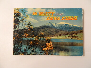
Postcard (fold out) - Mt Beauty and the Kiewa Scheme, Victoria, Mt Beauty and the Kiewa Scheme, c1960s
S. K Pearce owned shops in Mt Beauty and Tawonga. The postcard was used for tourism to attract visitors to the Mt Beauty township and the Kiewa Scheme on the Bogong High Plains. The postcard gives a brief history of the town and area both created by the State Electricity Commission of Victoria.The photos are historically significant and include prominent places in the Kiewa Valley, Mt Beauty and the Bogong High Plains. S. K Pearce was a prominent shop owner in the area having shops in Tawonga and in Mt Beauty as seen in one of the photos. The postcards are of interest as they are an example of advertising for tourism in the 1960's.Fold out postcards including a panel on information on Mt Beauty and the Kiewa Scheme, 12 colored labelled photos, an address & letter written in black biro. Multiple copies.Letter from Roma to 'Dad and Chris'. Their address in Bayswater. Postage stamp from Mount Beautymt beauty, kiewa hydro electric scheme, s. k. pearce, tourism -
 Kiewa Valley Historical Society
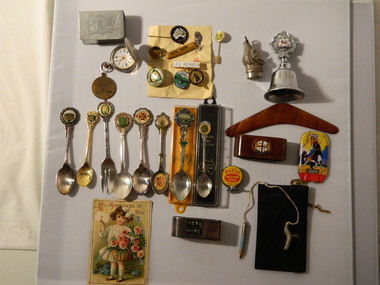
Collection - Personal - Dorothy Anderson
Organisations that Dorothy Anderson belonged to included many items to represent their clubs eg. badges, spoons, activities eg. crocheting. Dorothy lived in Tawonga indicating that those clubs existed in the town/area and were typical of regional areas of the time. These items were the property of Tawonga Citizen, Mrs Dorothy Anderson, who passed away in 2014, aged 90 years. She belonged to local clubs which existed in the area and acquired memorabilia belonging to those clubs and activities thus giving an insight into the life of women in regional towns. A personal collection of memorabilia stored in a black and cream solid but torn carry case with handle and broken clasp. Items include spoons, trophies, serviette rings name tags, member bar, pins, tea towel brooches, embroidered and crotchet items dance card pocket, birthday card, photos, pocket watch, bell, medals. Organisations: Tawonga Bowling club, CWA, Redcross, Doilies. Also refer to KVHS 0991 and KVHS 0992 Bogong Hotel On top of case written in blue biro: Laurie Anderson, Tawonga / via Wodonga / Phone No. 17tawonga., dorothy anderson, clubs, cwa, red cross, bowling club, memorabilia -
 Kiewa Valley Historical Society
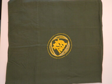
Tablecloth - CWA
The Country Women's Association of Victoria was a popular widely known organisation throughout Australia. The CWA aimed to improve health, welfare and education for women and children in the country.Each town / area in the Kiewa Valley had an active CWA. The Tawonga branch commenced in Feb. 1946 and often combined activities with other branches in the Kiewa Valley. One of their activities may have been to play cards.Green cotton square tablecloth for a fold-up card table. It has an yellow with a little bit of white embroidered circle / emblem in one corner. Inside the circle is "Victoria' and CWA (on top of each other as per the CWA emblem.) The edges are hemmed and a seam runs around all edges so that the square sits correctly on the table.Victoria CWAcountry women's association, tablecloth, community, volunteers, women, charity -
 Kiewa Valley Historical Society
Postcard - Bogong Village x2
Bogong Village became a tourist town after the State Electricity Commission of Victoria sold it upon the completion of the Kiewa Hydro Electric Scheme.Bogong Village was built by the SEC as a town for its employees on the Kiewa Hydro Electric Scheme. This card represents the village in later years when it was being promoted as a holiday resort.Cover: 5 colored photos of Bogong Village with a blank space for writing the address and affixing the postage stamp. Other side is covered with horizontal parallel lines on which to write. Paper is made to fold into three with gum at the top to seal.bogong village, tourism -
 Kiewa Valley Historical Society
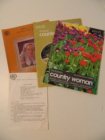
Journals - C.W.A, Victorian Country Woman for Country & City Women
Country Women's Association of Victoria was a popular widely known organisation throughout Australia. The CWA aimed to improve health, welfare and education for women and children in the country.Each town / area in the Kiewa Valley had an active CWA. The Tawonga branch commenced in Feb. 1946 and often combined activities with other branches in the Kiewa Valley.1. Nov. 2000, Vol. 46, No. 10. Cover: Purple & red tulips 2. October 2004 Vol. 50, No. 9 x2 Cover: Olive Green surrounding oval shaped photo 'The Log Cabin' 3. April 2001, Vol. 47, No. 3 Cover: Mustard surrounding square portrait of 'Nursing Sister Atherton, N. Qld.' 4. Agenda for the Annual Conference of the Kiewa Valley Group of the CWA of Vic.Also includes National Anthem, CWA Collect & Mottocountry women's association, journals, kiewa valley group of cwa -
 Kiewa Valley Historical Society
Set of 2 hand coloured photographs of early Mount Beauty, photographs of Mount Beauty, 1947/48
Construction of the town of Mount Beauty commenced in 1946 and continued until 1952. It was built to provide family accommodation for workers engaged in the construction of the hydro electric power scheme. As well as housing, there was an administration building, staff hostel, merchandising centre, workmen's camps, base stores and workshops and the Mount Beauty Terminal Station. The first house was occupied in November, 1946 by the then manager of the trading store, with a frontage onto Hollonds Street. The total number of houses erected was 488, 162 custom built and 326 prefabricated. The main workmen's camp can be seen just left of the centre of the photograph and accommodated 144 men at the time of the photograph. By 1950 it could accommodate 1200men. Photo No. 1 is taken in 1947/early 1948 as there is no evidence of the staff hostel under construction. This hostel was commenced in August/September 1948 and is clearly shown in photograph No. 2, dating this photo as 1948 as it is before the completion of the bypass road connecting to the main (high plains) road. This road was constructed in 1939 and in 1948 followed the route of Tawonga Crescent. This remained in use until the bypass construction was completed in early 1949 and does not appear to be finished in this photograph.. Both photographs are taken from the power line easement adjacent to the Bright road.Significant historical pictorial record of the development of a town from grazing land. The type of terrain that had to be surveyed and then to construct roads and other infrastructure, with very little machinery, is also of prime significance in the development of the Kiewa Hydro Electric Scheme.Two photographs, both hand painted to show colours, and both of Mount Beauty c 1947/48 not long after commencement of construction of homes and facilities for workers.Photo No.1 - on back of photo, left upper corner, faintly in pencil, SPIKE, underneath this is written T Pay,. Photo No. 2 - on back of photo, left upper corner, faintly in pencil, Jmount beauty, housing, accommodation -
 Kiewa Valley Historical Society
Photo of Bogong Village, c1940's
The SECV constructed the Kiewa Hydro Electric Scheme from the lat 1930's through to the 1960"s. Bogong Village was the first town built to accommodate workers and their families.The Kiewa Hydro Electric Scheme involved local people living and working in Bogong.Small black and white photo with white border. Bogong village with Lake Guy in foregroundOn Back, handwritten in ink, "Bogong Village on Lake Guy"bogong village, secv -
 Kiewa Valley Historical Society
Papers - Jim Goonan's Story - Dederang, 1950's
Early settlers came to Dederang from Kergunyah. The main road, Dederang to Tawonga was opened about 1860 - 1864, connecting 'Crosthwaite's Gap' with 'Smith's corner'. Jim Goonan's ancestors selected land between Dederang and Tawonga in the early 1860's.A comprehensive history of the town of Dederang from the 1860's up to the 1950's. Early settlers, infrastructure, businesses, activities including sport and life style are described giving an insight into how the Kiewa Valley developed during this time.26 typed pages of the History of Dederang. Each page consists of paragraphs with a heading.dederang, jim goonan, kiewa valley -
 Kiewa Valley Historical Society
Papers - Tawonga & Mt Beauty
Red Cross, CWA, Bowling Club histories in Tawonga and Mt Beauty written for a book, title unknown.The histories of the Red Cross, the Country Women's Association and the bowling clubs in the towns of Tawonga and Mt Beauty are important as the communities in the Kiewa Valley were involved in these organisations for many years from the mid 1940's and in the case of the Tawonga bowling club since 1953. The number of people, their activities and infrastructure associated with the clubs give an insight into how people lived during the times that the clubs existed.Papers from chapter 4 entitled 'Community Organisations' and chapter 5 entitled 'Recreational Activities & Opportunities' from an unknown book. These cover the townships of Tawonga and Mt Beauty and include black & white photos.red cross, country women's association, bowling clubs, mt beauty, tawonga -
 Kiewa Valley Historical Society
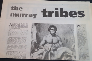
Newspaper Article - 'The Murray Tribes' and 'Back to Beauty', October 10th 1998
The Murray Tribes written by Cliff Chamberlain a general history of the Aborigines possibly as reported in previous newspapers. The Back to Beauty article was a report of the 50th anniversary of public education in Mt Beauty.The Murray Tribes visited the Alpine areas in pursuit of the Bogong Moth. Public Education began in Mt Beauty in 1948 as a result of the number of children living in the town. Their fathers working for the State Electricity Commission of Victoria on the Kiewa Hydro Electric Scheme.Newspaper Article entitled 'the murray tribes' and on the back 'Back to Beauty' - the Border Mail Saturday Oct. 10, 1998aborigines, bogong moth, public education, mt beauty -
 Kiewa Valley Historical Society
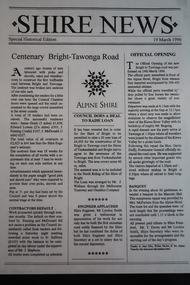
Papers - Centenary Bright-Tawonga Road, 19th March 1996
The Bright-Tawonga Road was built in 1896, connecting the Ovens and Kiewa valleys. The article gives an description of the event.The Bright - Tawonga road connected Tawonga to the larger town of Bright and the closest railway service. This road provided the Upper Kiewa Valley with access to larger markets, alternative transport and increased facilities not available in the Kiewa Valley in the early, pre SEC days. It describes how roads were built in 1896 with little machinery. The KVHS has in its collection the dray used to help build the road. One page article from the 'Shire News' dated 19th March 1996bright-tawonga road, road works, kiewa valley, ovens valley, dray -
 Kiewa Valley Historical Society
Papers - Settlement Study - Mount Beauty 1971 x5, October 1971
Similar to a census for Mount Beauty in October 1971. Topics include Income, family, the town, society and travel outside the town.The results of the survey give an insight into the community of Mt Beauty after the SEC days, the infrastructure available and the activities of the population living in the town. This would also enable a comparison to be made before or after 1971.Typed papers on the Settlement Study results in Mt Beauty Oct. 1971. Each page gives the question asked and the number of people responding in each given area. The papers are dated October 1971.mt beauty, census 1971, statistics -
 Kiewa Valley Historical Society
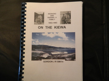
Book - On the Kiewa, Working & Raising a Family 1953 - 1963 by Gordon J. R. Smith, 9th September 2005
Personal account of Gordon Smith's life when living in Mt Beauty and Bogong townships while working for the SECV on the Kiewa Hydro Electric Scheme.Gordon gives an account of both working and living during the 1950s and early 1960s in a remote part of Victoria - the Kiewa Valley and in 2 small construction towns. He gives a lot of detail eg. the weather, his work, the people, the activities, his family and leisure time.Plastic threaded spine holding 282 pages with black and white photos. Front Cover includes 2 small black and white photos either side of the title at the top and below the title a larger colored photo of Rocky Valley Dam. Author's name is underneath. "Dick Puttyfoot" on cover page.kiewa hydro electric scheme, state electricity commission of victoria., gordon smith -
 Kiewa Valley Historical Society
Trophies - Tawonga Bowling Club x2, 1.1986. 2. 1987
Bowling in the Kiewa Valley is a popular sport with clubs in each town along the Kiewa Valley. Trophies are a common way of acknowledging winners in the various catagories.Vera Hore lived in Tawonga and was a successful bowler.1. Plastic silver V shaped trophy with Ball enclosed at top. On the ball are 2 bowls in black and blue with a blue kitty. These are surrounded by green. The trophy is mounted on a wooden block which has an inscription on a gold plate at the front. 2. Gold plastic woman bowler mounted on a wooden block which has an inscription on a gold plate at the front.1. 'Vera Drummond Trophy / 2.2.1986 / V. Peers (S). V. Hore, G. Hobbs' 2. 'Muriel Jobling Memorial / 1987 (3RD) / V. Hore' 2. Stamped underneath - "The Trophy Centre / 558 David St. Albury / Ph. 216588"tawonga bowling club, vera hore -
 Kiewa Valley Historical Society
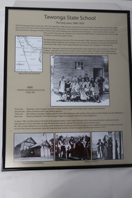
Posters - "Tawonga Remembers" x 5, 2016
The town of Tawonga is in the Kiewa Valley surrounded by farmland. It is adjacent to Mt Beauty (built from 1946), an SECV town built for workers on the SECV's Kiewa Hydro Electric Scheme, which was being constructed from 1911-1961. Tawonga consists of essential amenities including a store, school, post office, butter factory, sporting facilities, hall and hotel. Activities involved sport, social get togethers eg. dances, fund raising, CWA etc.The posters are a collection of historical photos, documentation and information re the history of the town of Tawonga, which is the centre of a farming community in the Kiewa Valley.Posters framed with thin black plastic strip, covered by glass. Each one has a title re "Tawonga Remembers" and includes print and photos in black and white. These have a beige background. 1. Tawonga 1907; 2. Tawonga 1962; 3. Tawonga State School- 1880-1929; 4. Tawonga Primary School -1960; 5. The Beginning of Change: 1930-1970tawonga, photos of early tawonga, kiewa valley, tawonga remembers, tawonga school -
 Kiewa Valley Historical Society
Photographs – Kiewa Cres Mt Beauty. Circa 1993. Set of 12 colour photographs, circa 1993
... green space around the town centre. kiewa crescent mt beauty ...Established in 1946, during the construction of the Kiewa Hydro Electric Scheme, the township of Mt Beauty was developed by the State Electricity Commission of Victoria to provide additional accommodation for the thousands of workers during the construction of the country’s second largest hydro-electricity scheme. Although these towns were built as temporary accommodation for the workers and their families, many stayed after the scheme finished. Combined with the influx of European migrants, with their rich cultural backgrounds, all played a major part in shaping the future character of the Mount Beauty, the Kiewa Valley and Falls Creek. The Bright Council, now the Alpine Shire took over the control of the township in 1960. This relatively young town of Mount Beauty, along with the surrounding townships of Falls Creek, Bogong, Tawonga South and Tawonga, are all part of a prospering tourist area with excellent services, accommodation, food and a wide range of recreational activities available for all ages. According to Shire records, the population of Mt Beauty has grown from 1,500 in 1981 to 1,800 in 2016 with a projected increase to 2,000 in 2013The photographs taken around 1993 show a prosperous commercial centre catering for both locals and the needs of visitors. It provides a pictorial history of the changes which have occurred in the retail/commercial district of Mt Beauty over the years. It also demonstrates the attention paid by Alpine Shire towards providing accessible recreational green space around the town centre.Set of 12 colour photographs Kiewa Cres Mt Beauty. Circa 1993 showing retail services and streetscape of the time. No markingskiewa crescent mt beauty; shopping centre;