Showing 1450 items matching "water victoria"
-
 Kiewa Valley Historical Society
Report - Alpine Study Area Volume 2 Maps, Land Conservation Council, 1970s
The Victorian Environmental Assessment Council and the former Environment Conservation Council (ECC) and Land Conservation Council (LCC) have completed 36 land use investigations over more than 35 years, including 27 regional reviews. They provide a framework for use of Public Land in Victoria. The Land Conservation Council was established by the Land Conservation Act 1970.These maps provide an assessment of the Alpine area at the time the maps were created. Some of the topics eg. Rainfall and water resources may change over the years thus providing a comparative analysis. Others may provide information for future development such as mineral exploration, building of a dam / tunnel etc.Blue box shaped folder containing 9 of 10 Maps of the Alpine Study Area produced by the Land Conservation Council. Maps include 1. Public land and descriptive blocks. 2. Physiography. 3. Topography. 4. Geology (missing). 5. Rainfall and water resources. 6. Vegetation 7. Land systems. 8. Recreation. 9. Primary production. 10. Minerals Ex library item. Stamped in red "Discarded From Stock / Swan Hill Regional Libraryalpine area, maps of alpine area, land conservation council -
 Kiewa Valley Historical Society
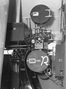
Photograph – Black and white photograph of an unidentified piece of equipment (possibly projection equipment) presumably used by SECV Hydro
The Victorian Government took control of power generation in 1921, forming the State Electricity Commission (SEC). Construction approval on a grand scheme to build five power stations with a combined capacity of 289 megawatts was received in 1938, and the Clover Power Station was completed by 1945. The original scheme was dramatically pruned after World War II and only two more power stations were built. The Junction Dam and Clover Dam Power Station, stages of the Kiewa Hydro-Electric Scheme, were needed to meet the increased power demands of the wartime industry in Victoria. Clover added 26 megawatts to the grid. Junction Dam was completed and ready to hold water by September 1943, but was emptied in December 1943 and not filled again until May 1944. Construction of Clover Power Station commenced in July 1941 and both turbines were in service by May 1945.Clover Power Station and Junction Dam were part of the Kiewa Hydro Electric Scheme constructed by the State Electricity Commission of Victoria.Black and white photograph of an unidentified piece of equipment (possibly projection equipment) presumed to be used in one of the power stations ie: Clover Power Station or Junction Dam as part of the Kiewa Hydro Electric Schemeprojection equipment; -
 Kiewa Valley Historical Society
Booklet - Victoria's Hydro Power x2, Victoria's Hydro Power - SEC, August 1975
The State Electricity Commission of Victoria built several hydro power stations from 1928-1981. This book names each - up to 1975 - with a summary and explanation.The State Electricity Commission of Victoria built the Kiewa Hydro Electric Scheme which included the construction of Bogong Power Station, McKay Creek Power Station and West Kiewa Power Station. It also established infrastructure such as the townships of Bogong and Mt Beauty and the opportunity for tourism in the area Colored green/blue 'splash' of water on front cover with SEC logo in white centred under the yellow printed title. On the back cover is the SEC logo at the bottom in the middle.state electricity commission of victoria; kiewa hydro electric scheme; mckay creek power station; clover power station; west kiewa power station -
 Kiewa Valley Historical Society
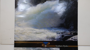
Booklet - Southern Hydro, Southern Hydro
Southern Hydro Ltd. was established in the late 1990s as a result of the disaggregation of the former State Electricity Commission of Victoria. It operates 10 power stations mainly in the north-east of VictoriaSouthern Hydro continued to encourage tourism as did the former State Electricity Commission of Victoria. This brochure is very similar to one previously published by the SECV "Victoria's Hydro Power" except only including those that it operates. Within the KHES the power stations were McKay Creek, Clover and West Kiewa. The change of ownership of hydro power from a government body to private enterprise in the late 1990s is of significant interest to the historian and consumer.Colored photo water spraying onto rocks with black strip across the bottom and logo (4 gold lines forming an "S", a blue triangle with grey cylinder beneath) of Southern Hydro within the strip. Back cover has a similar photo with 4 small photos of men inserted in the black column. This 23 page book gives a history of Southern Hydro and its 10 hydro-electric power stations that it operates. The book lists these and gives a description of each.Top right hand corner of page 5 has a piece of tape stuck over the print with "Page 11 to photo copy & enlarge" secv; khes; mckay creek power station; clover power station; west kiewa power station; mount beauty; rocky valley dam; -
 Kiewa Valley Historical Society
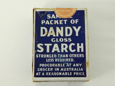
Box Sample Dandy Starch, circa mid to late 1900's
This brand of starch was first manufactured in 1914, during the First World War, and continued to cover the other wars and military conflicts that followed. It was a time when Australian made was important due to the limited supplies coming from England and Europe. This was a period when the demand for "home grown" produce was at its peak. This was in a time when by necessity not by the "Buy Australian" campaign (of later years) which was the major factor for the demand of goods. It was in a time when starch was used in formal clothing to put a "crisp" or fresh new appearance for clothes. The important social more of "clothes make the person" was in vogue. This is a sample box provided by the manufacturer as an advertising and promotional method of prospective customers becoming aware of the product. This type of promotional avenue brought results and ensured that this type of advertising and inducement by manufacturers would be ingrained as a lasting avenue through to the 2nd Millennium This box which once contained starch powder is very significant to a rural semi isolated region because it clearly demonstrates that the social mores of the city were also entrenched into the rural population. The fashion of the day, even in remote areas, especially rural, were still a requirement to be maintained on certain special occasions. Cleanliness and stiff "upper lip" persona were just as important in the rural sector as in city and Government circles. Institutions such as hospitals, Government Offices and the legal personnel were bound by the fashion of the starch appearance (no dirt sticks to a personage with the "starch" look). Appearances, especially the first ones, were the judgmental image that remained in the uppermost regions of the viewer.This box with white writing and a "formally clad" man on a navy blue background held Australian grown maize based starch powder(1 LB gross). The package is made from 200 gsm thick cardboard. As production was made during the two World Wars 1914 to 1945 the promotion was heavily focused on Australian made and Australian grown maize.The front(has "Sample" on top) the rest inscriptions are the same on each cover both and back, "DANDY" below this a figure outlined in white on a navy blue background "hat and tails" outfit. Next to the sketch in smaller lettering" STRONGER THAN OTHER STARCHES. LESS REQUIRED". Below the figure "GLOSS" and below this in larger print "STARCH". Below this and in smaller print "CONTENTS. NETT WEIGHT 14 1/2 ozs" Below this and in smaller print "MANUFACTURED BY MAIZE PRODUCTS PTY LTD FOOTSCRAY VICTORIA" On one side of the box and in large white print on royal blue background"PURITY, STRENGTH AND UNIFORMITY." On the other side are the manufacturers directions. On the left side "FOR RAW STARCH" Underneath and in smaller print,"Dissolve in warm water a quantity to give the required thickness. Add bluing if required Stir before each using. On the right side "FOR BOILING STARCH" underneath this in small print"Mix well in small quantity of cold water to creamy consistency. Add boiling water, and stir constantly while cooking. Allow to cool, and add blueing if required. Underneath these two sets of instructions is "Make your consistency thinner than if using another kind of Starch"household starch, household cleaning, domestic laundering. -
 Kiewa Valley Historical Society
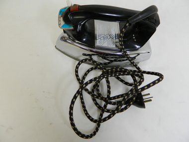
Iron - Electric
From c1950s electrical irons were used. The thermostatic iron followed the electric iron used with a container that enabled water to be sprayed onto the cloth. Damp cloth was more easily pressed. This thermostatic electric iron was one of the early models.This iron was used by residents of the Kiewa Valley including those living at Mt Beauty where there was electricity and an SEC shop from c1950.This is a "General Electric" iron. It has a steel base with a chrome upper and black plastic handle. It is thermostatically controlled with water spray. The electric cord is permanently attached, at right angels, to the handle base. A red button activates the water spray when pushed. A white button slides to enable fabric selection. A metal hole in the front of the handle is used to fill the iron with water.General Electric; Wash and Wear / Wool / Cot / Lin; Australian General Electric Appliances Pty Ltd.; Notting Hill Victoria. 1100 Wats 240 Volts AC only. V/A2F Cat. No. 10 FS10iron;, electrical appliance, laundry, domestic, pressing clothes -
 Kiewa Valley Historical Society
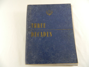
Book - Historical - SECV x3, Three Decades. The Story of the State Electricity Commission of Victoria from its Inception to December 1948, First Published March 1949
At the time of writing this book The State Electricity Commission of Victoria had been in existence for 30 years. This book tells something of its progress and achievements during that period. It includes brown coal and water power. The Commission was to develop and use these natural resources through the expertise and experience of the Commissioners, its staff and employees. Historical: Chapter 5 "The War Years - and Kiewa." describes the early stages of the Kiewa Hydro Electric Scheme. Photos, map and diagrams of the Kiewa Scheme are also included. Hard cover blue bound book with the SECV insignia and the title "Three Decades" both in gold on the front cover. Book includes coloured and black and white photos.Handwritten inside front cover: "Bob Burnett". Title page: hand written in print and crossed out: "L.D.Miller / Tawonga". Not crossed out - "(Cheryl)"state electricity commission of victoria. kiewa hydro electric scheme. bogong high plains. pretty valley. kiewa valley. -
 Kiewa Valley Historical Society
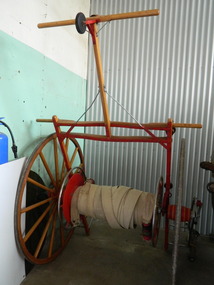
Fire Hose Reel, c1950s
The fire hose reel was purchased by the Fire Ladies' Auxiliary for the Mt Beauty S.E.C. Fire Brigade in the late 1950's for over 1000 pounds. Initially they competed with Bogong fire brigade as both were 'Industry' Fire brigades - both owned by the State Electricity Commission. Competition was at 2 levels - north east Victoria and state competitions involving rural and urban brigades with a difference in the equipment. Mt Beauty was/is an urban brigade whereas Tawonga is a rural brigade. Competition involved members to improve their skill, keep fit and was a very social occasion. After the Shire took over Mt Beauty township in 1961, the Fire Brigade ran by itself but soon became affiliated with the C.F.A. because of insurance and legal liability e.g.. enabling them to stop traffic or wreck buildings if required. The CFA were not happy with the Mt Beauty truck so a new one was obtained while the old one went to Bogong. Competitions gradually ceased as it was a young man's sport and young members had prior commitments. The reel was donated to the KVHS in the mid 1980's as it failed to be sold as it competed with new, cheaper, aluminium reels. The practice strip was located beside the fire station in Lakeside Avenue. This fire hose reel was used by the Mt Beauty Fire Brigade for demonstrations at competitions during the 1950's and 1960's. The Mt Beauty Fire Brigade Team won the competition in 1966 at Wangaratta. The score was close against the home team and was decided on a play off. The team benefitted by the man who wound the hose on allowing it to end up at the easiest height to handle when full of water and very heavy.The Mt Beauty Fire Brigade was an 'industry' fire brigade belonging to the State Electricity Commission of Victoria from the 1940's. It became a member of the Country Fire Authority in the early 1960's. During the 1950's and early 1960's members would compete with other local fire brigades in competitions against other brigades in the north east of Victoria using skills such as unwinding the hose off the reel and turning on the water in record time. The Mt Beauty Fire Brigade continues today as an urban fire brigade affiliated with the CFA.Varnished wooden cart reinforced by painted red steel frame. The wheels have 14 wooden spokes and steel around the outside of the wooden wheel. A long canvas hose is wound around a central winding cylinder. The cart has a wooden handle with a rubber jockey wheel at its end. There is a brass hose nozzle attached by a stainless steel frame on the outer side near one of the wheels.Each Reel: "Mt Beauty F.B." yellow print outlined in black with red background.fire hose. mt beauty fire brigade. country fire authority. fire reel. -
 Kiewa Valley Historical Society
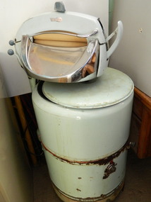
Washing Machine - Wringer
This electric washing machine was typical of the machines in the homes of Mt Beauty during the 1950's. This one has a wringer attached enabling the washing to be pushed through squeezing the water out after washing.Mt Beauty township was constructed in the early 1950s with electricity connected. Residents were employees of the State Electricity Commission of Victoria and worked on the Kiewa Hydro Electric Scheme.Metal green cylinder standing on 4 roller coasters. Cylinder has 3 sections - bottom short & yellow, the rest divided into 2, each section is held by a strip of steel bracing. The top section of the cylinder is hollow with a stainless steel metal agitator with 3 'wings'. The cylinder has a rotatable switch on the outside and a moveable knob. Opposite on the outside is a metal pipe widening to the wringer which hangs above the cylinder. The green wringer has 2 cloth covered cylinders that can be separated by moving knobs. A flat stainless steel curved flat surface comes out at an angle below the cloth cylinder. An electric cord is attached. The cylinder has a lid with a knob in its middle.On the wringer: "Stampco"electric washing machine. mt beauty. s.e.c.v. kiewa hydro electric scheme. home duties. housework. wringer washing machine. -
 Kiewa Valley Historical Society
Map - Topographical, Ski Club of Victoria Bogong High Plains and Adjacent Peaks, Early 1930's
This map has been in the Ryder family for approx. 70 years. Probably used when bush walking and skiing in the early days on the Bogong High Plains. The Ryder family are farmers in the Kiewa Valley and were involved in taking their cattle up to the Bogong High Plains where they had a lease. The State Electricity Commission of Victoria constructed the Kiewa Hydro Electric Scheme opening up the area during the 1940's and 1950's. This type of map is an early one, used by people in the Kiewa Valley and possibly by surveyors prior to construction.The map is an early topographic map used by farmers living in the Kiewa Valley. It is historically significant as these people were involved in taking cattle up to the High Plains during summer and may have been used for bush walking and skiing.This is a sepia coloured paper map which was originally printed copyright registered. It was revised in 20/6.33/4.4.37/8.4.40/24.8.43/19/6/54. It shows roads / tracks / snow poles / snow pole numbers (27) / Snow pole spacing (3 chains. 66 yards) approximately 27 poles to the mile / height above sea level in feet - 5280. Water courses not definitely located etc.Rocky Valley Dam (Kiewa Hydro Electric Scheme) has been drawn on the map by hand with a biro. There is a wooden rod at the top of the map.topographic map; kiewa valley; ryder family; high plains of victoria -
 Kiewa Valley Historical Society
Evacuation Plans for children during WWII, 1941
During World War 2 the State Emergency Council for Civil Defence (Victoria) sent out forms to Municipal Councils requesting a survey to be carried out regarding the suitability of householders to accommodate persons, especially children, in the more dangerous parts of Victoria. Also, surveying parents as to their wishes regarding the evacuation of their own children if necessary. The documents list householders living in the Kiewa Valley including Gundowring giving an insight into the families (size, age, religion, sex), the homes (size, number and type of rooms), Water supply, Conveyance (motor or horse drawn), distance from railway station and school. Papers created by the State Emergency Council for Civil Defence, Premier's Department 1941 requesting Municipal Councils to survey people in case of the billeting of persons who may be evacuated from the more dangerous parts of Victoria. The Accommodation Survey lists the householder, details of the house, how many people living there and how many could be accommodated.There are also forms asking householders if they wish their children to be evacuated if necessary.Forms filled out in ink. world war ii; evacuation plans; kiewa valley; gundowring -
 Warrnambool and District Historical Society Inc.
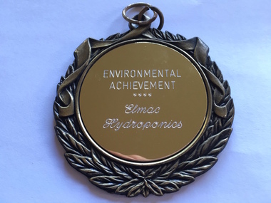
Medallion, Trophy Environmental achievement, 2000
This is a medallion awarded in 2000 by Powercor Warrnambool to Elmac Hydroponics. Powercor Australia, founded in 1994, is an electrical distribution company operating in the Western District of Victoria and the western suburbs of Melbourne. Powercor Warrnambool, like other Powercor organizations, is involved in giving Business Excellence Awards annually to businesses in its area of supply. In 2014 there were 15 awards for Business Excellence. Elmac Hydroponics was a business growing and supplying organically-produced tomatoes from 1997 to 2004. It was situated at Mount Pleasant, Princes Highway, Allansford, Victoria. The business was operated by Graeme and Barbara McLeod and Keith and Leonie Ellerton. Hydroponics is a system of growing plants without soil, using a nutrient solution. Elmac Hydroponics had a 2,000 square metre greenhouse with 10,000 growing points. This is a significant medallion, showing the award given to a small business in the Warrnambool area and indicating its achievements in the environmental area. Elmac was an industry leader in in implementing an ‘Autopot’ hydroponic system which is aimed at reducing nutrient and waste water to zero. Elmac was also a finalist in the Ericsson 2002 Innovation Awards.This is a gilt metal medallion, oval-shaped, with an ornamental edging and a shield-shaped design on one side and a circular design on the other. The top has two metal rings for attachment to a chain or wall hook. On one side: ‘Environmental Achievement, Elmac Hydroponics’ On obverse side: ‘Powercor Warrnambool Region Business Achievement Awards, 2000’ elmac hydroponics, powercor business awards, warrnambool -
 Warrnambool and District Historical Society Inc.
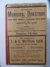
Stamp, W'bool Co.op Commons Seal, 1945
This is a Victorian Municipal Directory for 1945, containing general information on all municipalities in Victoria, a Gazeteer, a Commonwealth Guide and a Water Supply Record. Municipal Directories were published annually in Victoria from 1867 on. This directory came from the Shire of Mortlake which was established in 1864 when it had an area of 2137 square kilometres. The Shire of Mortlake was abolished in 1994 and merged with other neighbouring shires to form the present day Shire of Moyne. This book is very useful to researchers as it contains much information on the City, Borough and Shire structures, the Council employees and Government employees of all the municipalities. It has, therefore, important local information on Warrnambool and the surrounding areas in 1945. This is a soft cover book of 1114 pages. It has a buff- coloured cover with red binding on the spine. The printed material on the covers is printed in black. It has a blue stamp of the Shire of Mortlake on several pages. The book contains several advertisements for Melbourne businesses. ‘Shire of Mortlake’ shire of mortlake, local government in victoria, warrnambool history -
 Warrnambool and District Historical Society Inc.
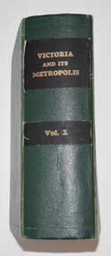
Book, Victoria and its Metropolis Vol 2, 1888
Information on the of Colony of VictoriaThe book has a green cloth cover with an indented pattern. The spine has gold printing on black cloth attached to the green cloth. The 820 pages are gilt edged and, to some extent, are water damaged. They contain printed text and lithographs .Some original pages relating to Warrnambool have been removed and replaced with photocopies which are pasted in. There are fold out coloured maps.non-fictionInformation on the of Colony of Victoria warrnambool history, history of victoria -
 Warrnambool and District Historical Society Inc.
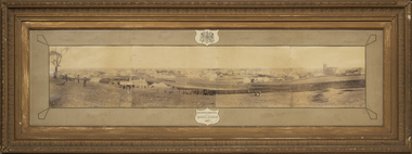
Photograph - Framed photograph of Warrnambool 1887, Town Panorama. Warrnambool Queen's Jubilee 1887, 1887
This is a framed photograph of a panoramic section of the Warrnambool township taken in 1887 to commemorate the Jubilee of the reign of Queen Victoria (1837-1887). The photograph is taken from Booval Hill (Liebig Street north) and shows the fencing in that area with groups of people in the foreground posing for the photograph. The panorama covers Liebig Street and Raglan Parade and includes private houses, a windmill and three tanks, St. John's Church, St. Joseph's Church, Tattersalls Hotel and the Saleyards.This photograph provides us with historical information on a section of the Warrnambool township in 1887 and is a valuable resource for researchers.This is a black and white photograph in a brown wooden frame and enclosed in glass. The photograph has a gilt metal edging outlined with ornate kite-shaped pieces on the corners and depicts a section of a town from an elevated position. At the top of the photograph is a crest in a shield shape and at the bottom is another shield shape containing the title of the photograph. The left centre section of the photograph is splotched or water-stained.Warrnambool Queen's Jubilee 1887warrnambool 1887, queen victoria's jubilee -
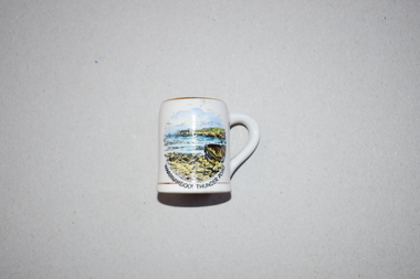 Warrnambool and District Historical Society Inc.
Souvenir, Victoria Fine China, Miniature mug Warrnambool Thunder Point, C 1940
Warrnambool has been an attraction for tourists for over 100 years. It has been popular as a coastal resort and today the winter whale season brings more tourists. In the late 19th and early 20th centuries Warrnambool was promoted as a spa and health resort, partly because of its hot and cold sea water baths and partly because of its bracing climate and attractive coastline. Thunder Point, depicted on this item, has been a popular visiting spot for tourists for many years. Buying a high quality ornament such as this one was a popular activity of tourists in the mid 20th century. Tourists today buy souvenir items but the choice and range vary from what was available 80 years ago. This item is retained as an example of a local souvenir bought by tourists in the mid 20th century. This is a small white china mug with a gilt edging or strip around the top opening rim, the base and the handle. There is a colour image of a seascape in blue, yellow and black on the side of the mug and the maker’s name on the base.‘Victoria Fine China’tourism in warrnambool, souvenir china items 20th century, history of warrnambool -
 Port of Echuca
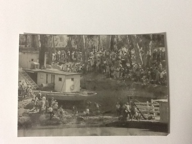
Black and white photograph, 04/03/1984
Photograph related to no.P000041, P000045 - P000048 of P. S. Adelaide re-floating. Copyright held by Riverine Herald newspaper. Original and negatives held by Riverine Herald.. Photograph taken from the river looking west towards the Echuca bank. Spectators line the higher banks and to the water line in the foreground. The back of the Adelaide and funnel is in clear view with the wheelhouse being partially obscured. The re-floating of the P. S. Adelaide was a Significant community social event evident by the number of spectators in the photograph. The community had invested a great deal of time and money into re-floating the paddlesteamer. The newspaper covered the event in detail with a number of action shots as the boat made its rear entry from the soil ramp to the water.Black and white photograph of the P. S. Adelaide on a ramp being prepared for re-floating. Spectators line the higher banks. Photograph possibly taken from the river looking west towards the Echuca bank.p. s. adelaide, echuca,victoria, re-floating of the p. s. adelaide. riverine herald newspapers, -
 Port of Echuca
Black and white photograph, 04/03/1984
Photograph related to no.P000041, P000045 - P000048 of P. S. Adelaide re-floating. Copyright held by Riverine Herald newspaper. Original and negatives held by Riverine Herald.. Photograph taken from the river looking south west as the Adelaide enters the water backwards, from the soil ramp . The right hand side of the photograph is in shadow so is very dark. 2 people can be seen on the deck with possibly another boat moored beside the Adelaide and a small motor boat to the left of that.A significant social and historical event in Echuca as many local community groups had committed many hours and much money to re-float the Adelaide to add it to the stocks for the development of the Port of Echuca as a major tourist attraction for the region.Black and white photograph of re-floating of the P. S. Adelaide in the river, possibly still partly on soil ramp. Deep shadows on the right prevent detail of front of the boat and much of the right hand bow. There are spectators in a small motorboat on left of the Adelaide and possibly another boat coming along the side of the Adelaide (2 people can be seen on the left hand side of the Adelaide). 2 people are on the deck of the Adelaide.p. s. adelaide, echuca,victoria,re-floating of the p. s. adelaide. riverine herald newspapers, -
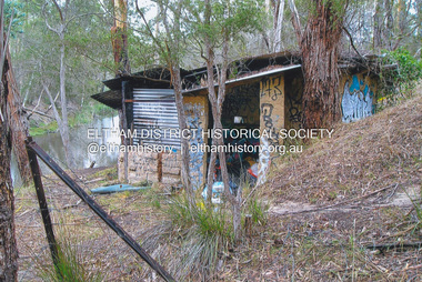
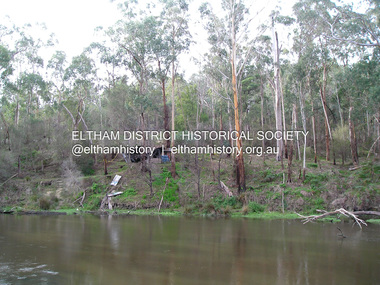
 Eltham District Historical Society Inc
Photograph, Fay Bridge, Old footbridge, 195 Laughing Waters Road, Eltham, n.d
This old footbidge is situated close to the shack that Gordon Ford built on the Yarra at Laughing Waters Road. Bernie Bragg also used to live there for a period of time. Gordon Ford and photographer Sue Winslow were married in 1965. They set up home in an old log cabin on the property Gordon had purchased in 1954 on Laughing Waters Road. Situated between the Yarra River and Overbank Road, Gordon had built a small mud-brick shack on the river and a pontoon. Over the decades the shack has been locally referred to as “the love shack”, the “rooting shack” or simply “Gordon’s shack”. Gordon and Sue commissioned local builder Graeme Rose to do a wattle and daub renovation and extension to the old log cabin on the north side of Laughing Waters Road. The work had only just been completed in 1965 when a bushfire swept through the area and destroyed the cabin. Gordon and Sue relocated to his property, Fulling, in Pitt Street, Eltham. In 1970 work started on a new house at the Laughing Waters property. Originally known as the Banana House, it is now known as Boomerang. Designed by Alistair Knox, the mud-brick house includes iron window grilles made by Matcham Skipper that puncture the curved mud walls. The grilles were made from ‘off-pressings’ from the Sidchrome tool works in Heidelberg. Gordon, Sue and family moved into the house in 1972. Their marriage fell apart and Sue moved to Sydney with the children around the same time Gordon commenced building Birrarung just below Boomerang on the Laughing Waters Road block. After the Fords moved out, Boomerang it was rented out to various share households of students, musicians, artists and environmentalists for twenty-four years. Gordon Ford sold Birrarung and Boomerang to Melbourne Water in 1999. The Laughing Waters Artist in Residence Program was developed as a partnership between Parks Victoria and Nillumbik Shire Council. Boomerang was deemed unfit for habitation so was used as a day studio only. By 2001 Boomerang was in a poor state of repair and by 2002 the last artist in residence was to use the house as a studio. Nillumbik Shire Council had been granted funds from the Melbourne Community Fund to restore both Boomerang and Birrarung but it was apparent in early 2003 that the funds would be insufficient to restore both houses. Boomerang was infested with termites which presented a risk to any occupants and so the decision was made to close Boomerang and concentrate funding on Birrarung. Boomerang was fenced off for safety and to prevent intrusion and remains ‘caged’ today (2023). However, it is readily apparent the property has been occupied by squatters over the years. By 2023 it was clear that the squatters had abandoned the property and sections of the roof structure have given away in some areas and collapsed internally. For a more in-depth description and history of the property and that of Gordon and Sue Ford, see Jane Woollard's book, "Laughing Waters Road; Art, Landscape & Memory in Eltham" published 2016.fay bridge collection, bernie's hut, birrarung, footbridge, gordon ford, gordon's shack, laughing waters road, love shack, yarra river -
 Eltham District Historical Society Inc
Film - Video (VHS), Diamond Creek Fire Brigade, c.1955-1987
Combination of three movie films. Movie One (1950s): 00:00 – 13:14 Black and white footage of Diamond Creek firemen practising in Diamond Street in the 1950s for forthcoming demonstrations of abilities. Mentions of Gordon Brandy and Joe Hislop Running out hoses from old hose reels along Diamond Street, Diamond Creek Displays from various brigades running out and connecting hoses. Also scenes from the 1950s of Diamond Creek Fire Brigade competing in various locations around Victoria and Tasmania. Mentions of Brigade members Dave Kidd, Bruce Hackett, Ron Kirkbride, Jack Marks, Graham Upton who are prominent in these events. Members of Kyneton Fire Brigade also present. Members competing in running out hose reels, connecting hoses togethers and to hydrants then climbing towers to direct water from hose or at a target hanging above the road. Diamond Creek members identified wearing a diamond on their chest and back. Includes scenes of Scottish pipe bands at the events and significant crowds of spectators. Footage of Mel Stone and Beryl Marks, Stan Redpath and Ron Kirkbride, then Ron Kirkbride and Eric Holt viewing flower displays. Film changes to colour at Diamond Creek oval for practice with fire engine entering oval. Members depicted include Bill May, Jack Sinclair, Jim Cox, Bob Beale, Dave Kidd, Bruce Hackett and Captain Clarrie Stone. Reverts to black and white in the 1950s where the Brigade joins forces with the Diamond Valley Community Hospital for a Gala Day on the Diamond Creek Oval. Changes to colour again, possibly same event and scenes of children on bikes and scooters or with prams and carts racing around the oval. Mention of young lad Brian Laurie who has his own fire truck. Dart throwing, pony rides. Scenes with Dr Don Cordner, Gus Lyons, Vic Cohn (?) and spinning wheel and Diamond Creek School children entertain a large crowd with Maypole dancing. Movie Two (1950s): 13:25 – 19:00 This black and white film was taken by a TV film crew in the 1950s depicts a typical call out for the Diamond Creek Fire Brigade. In this case the careless action of a member of the public throwing a lighted match from a car, which can cause extensive damage. Footage features the Shire of Eltham War Memorial tower at Kangaroo Ground before it was modified with a fire spotter’s cabin. Discusses fire spotting operations from the tower. Shows a fire spotter walking around the top of the tower. A fire is detected, and the information is relayed to the nearest fire station, in this case, Diamond Creek. The telephone call is received, and the alarm sounded. Captain Clarrie Stone and firemen May and Shaw leave their workplaces and prepare for action. Scenes of running across the Main Hurstbridge road showing the shops (Shell service station and Chemist prominent). Scenes entering the fire station which has a pictorial warning covering the entire door “Only you can prevent forest fires – If you’re careless – we’re homeless!” Eric Holt pinpoints the location of the fire while Captain Clarrie Stone and Fireman Shaw take note. The advance vehicle (an FE Holden ute, rego GTE-696) leaves to assess the extent of the fire. Having assessed the fire, Fireman Shaw communicates with base showing radio with call sign VL3JZ. Eric Holt takes the call. In the meantime, Captain Clarrie Stone and Fireman Shaw undertake some limited action to address the fire. Firemen Bill May, Jim Bates and Hugh Bar (?) man the tanker. A photo portrait of Queen Elizabeth is visible hanging on the wall. They are later joined by Firemen Jim Cox, Eric DeBuse (?) and Jack Marks. The tanker is seen departing the station and diverging off before the bridge. Captain Clarrie Stone and Fireman Shaw are seen pumping water on the flames with hand pumps when the tanker arrives. The hose is unreeled, and water turned on the flames. Jack Sinclair joins the action. Jim Cox directs water to the high stuff. The fire put out, Jack Marks and Eric DeBuse wind in the hoses and the team head back to town. It’s peaceful again at the memorial tower. Movie Three (1969-1987): 19:14 – 34:34 Colour film “Fired with Dedication”, Country Fire Authority Victoria, produced by I.L. Wadeson, Commentary by A.M. Hem. Credits with CFA Victoria emblem and then placed over a view of an old-style ladder engine. Opens with the scene of a fire engine outside the Diamond Creek Fire Station then various trophies reflecting the competition success of the brigade in various track and disciplined events. Two trophies shown of particular pride to the brigade were for first place in the Torchlight Procession at the State Championships in Mildura in 1986 and also at Swan Hill in 1981. Still photo scenes of ex Captain Clarrie Stone, Brigade Captain for 21 years; ex Captain Jack Marks, 10 years; ex Captain Ian Douglas, 10 years. Cuts to scene of radio control room, January 1969, and news of a fire on the northern side of the township of Diamond Creek. With scenes of flames in bush, the narration explains that until the early 1960s the area was an orchard district which protected the town against the savagery of bushfires. But due to competition from other areas more suitable for orcharding and easier transport to Melbourne the district could no longer remain competitive, and orchards were replaced by grassed areas, which together with the bush areas were a feeding ground for fire. On 8th January 1969, high temperatures and strong north winds, were, with the carelessness of some individual all that was necessary to produce the worst fire the district had seen. Cuts to scene of blackened fields and cattle - Hundreds of hectares of grass land were blackened, and cattle had to be transported to other areas for agistment. Scene of destroyed buildings in the township – 13 houses and the public hall in the town were destroyed as was the theatre equipment which was owned by the fire brigade. The Church of England Hall and bell tower were badly damaged. The whole town could have been burnt out but for the determination, skill, and courage of the Diamond Creek Fire Brigade. Scenes of all that was left of the home on the hill on the west side of the Church of England. Also, the remains of the old Pisy (?) home on the top of the same hill near Lambert Street, and the ruined Crocker home. Cuts to a scene in the mid-1970s to mid-1980s of a house fire in Haley Street attended by the Diamond Creek Fire Brigade. Although the house was severely damaged, it was saved. Mentions that whilst assistance is appreciated, in some circumstances, those doing so are not properly dressed for fighting fires. Breathing apparatus is a must in structure fire attack. Next scene (either on Mangarook or Coventry oval) showing off four Diamond Creek Fire Brigade efficient and very expensive firefighting units. Features a forward control vehicle Toyota 4WD used for conveying task force personnel to the required areas; a Hino Model 3.2 tanker, diesel powered and carries 3,000 litres of water and has a 16 HP petrol driven pump which delivers 900 litres of water per minute; an International tanker (registration TCM-418) which carries 3,000 litres of water with pumping capacity of 600 litres per minute. The Ford diesel powered pumper (registration MXE-754) is a well-equipped vehicle with a water capacity of 1,000 litres and capable of pumping 1,900 litres of water per minute from the main pump, has many lockers which hose equipment such as breathing apparatus and various types of hose nozzles and foam making equipment. The vehicle carries 360m of 64mm diameter hose which can be laid out from the rear lockers and a portable lighting plant, an Oxy Viva resuscitator to revive smoke inhalation victims and forcible entry tools to gain access to structure fires. Views of the main pump and control panel on the vehicle. As well as the main pump, the vehicle is equipped with an auxiliary pump which allows the facility to pump whilst moving. Fire fighters must undergo constant training and hone their skills, Scenes of a training exercise using the pumper to pump from static water. First, the short lengths of suction hose are coupled, a strainer fitted to ensure debris does not foul the pump. Gauges must be constantly monitored to ensure manageable water pressures are maintained. Pressures are normally controlled to allow two fire fighters to work at each nozzle outlet. Two nozzles are tested, one adjustable jet fog type which is used on flammable gasses or within a structure fire to absorb heat. A straight jet nozzle to project water long distances to protect exposed surfaces close to a fire radiated heat. The pumper is quite a versatile vehicle in handling structure fires, but it also carries specialist equipment needed in containing hazardous chemical incidents. Cuts to scene of parade – the Diamond Creek Fire Brigade has with other neighbouring brigades participated in most town fairs and earns the respect of the watching public. It can be seen why this brigade has been so successful at disciplined contests. Views of Plenty Fire Brigade Road Rescue unit which is equipped with the “Jaws of Life” Scenes of athletic competitions – many neighbouring brigades indulge in friendly but keen competition at the Diamond Creek Town Fair. The young are also encouraged to participate in all aspects of Junior Fire Brigade activities and become tomorrow’s generation of volunteer fire fighters. Scene of the 1986 Diamond Creek Town Fair which was the last time veteran Captain Clarrie Stone BEM marched with the brigade. Clarrie was awarded the British Empire Medal for his service to the Country Fire Authority. Also, scenes of vehicles in the parade. Cuts to scene of brigade members in drill formation for inspection by Acting Chief Harry Rothsay (?) on the occasion of the opening of the new fire station extensions on August 29, 1987. Rudy Libel (?) Captain at the time. Scenes of crowds including many dignitaries of neighbouring brigades present including Lieutenant Gordon Grandy (who came down from Queensland for the occasion) and ex-Secretary David Kidd and wife Betty, also ex Captain Clarrie Stone and Mrs Nel Stone, a life member of the Ladies Auxiliary, the Reverend Jock Ryan, son of J.L Ryan, founder of the Diamond Creek Fire Brigade, Foundation Captain of the fire brigade, Keith Bradbury and Mrs Bradbury. Pauline Dick accepts a community service award for services to the CFA. Recognising over 47 and a half years of service, a presentation is made by Mr Neil Marshall, Acting Chairman of the CFA to ex Captain Clarrie Stone with response by Clarrie. Other members of the official party include Cr. Martin Wright, Shire President Wayne Phillips and local Member of Parliament, Mrs Pauline Toner. Ex foreman John Bennett is presented with a life member’s awards by Captain Rudy Libel. The camera also catches Gwen Cox, Jean Ryan and Bessie Layton (?) Provides historic footage of people, places and equipment and a record of the worst fires expoerienced in Diamond Creek in 1969BASF Standard Quality SQ E-180 VHS dubbing (poor quality) of three films Converted to MP4 file format 0:34:38, 1.85GBOn label: "Donation - August 2000 Diamond Creek Unit Old films made up from Fire Brigade shows at competitions - also Kangaroo Ground Tower being used"video recording, diamond creek fire brigade, 1986 diamond creek town fair, a.m. hem, acting chief harry rothsay, athletic competitions, beryl marks, bessie layton, betty kidd, bill may, bob beale, brian laurie, bruce hackett, captain clarrie stone, chemist, church of england hall, clarrie stone, clarrie stone bem, country fire authority victoria, coventry oval, cr. martin wright, crocker home, dart throwing, dave kidd, david kidd, diamond creek, diamond creek fire station, diamond creek oval, diamond creek school, diamond creek town fair, diamond street, diamond valley community hospital, dr don cordner, eric debuse, eric holt, fe holden ute, fire damage – buildings, fire spotter, fire spotter’s cabin, fire station extension, fired with dedication (film), firefighting units, fireman shaw, firemen jim cox, ford pumper, foundation captain, gala day, gordon brandy, gordon grandy, graham upton, gus lyons, gwen cox, haley street, hino model 3.2 tanker, house fire, i.l. wadeson, ian douglas, international tanker, j.l ryan, jack marks, jack sinclair, january 1969, jaws of life, jean ryan, jim bates and hugh bar, jim cox, joe hislop, john bennett, kangaroo ground, kangaroo ground tower, keith bradbury, kyneton fire brigade, lambert street, main hurstbridge road, mangarook oval, maypole dancing, mel stone, mildura 1986, mrs bradbury, mxe754 vic registration, neil marshall, nel stone, orchard district, oxy viva resuscitator, pauline dick, pauline toner mp, pisy home, plenty fire brigade road rescue unit, pony rides, radio control room, reverend jock ryan, ron kirkbride, rudy libel, shell service station, shire of eltham war memorial, shire president wayne phillips, spinning wheel, stan redpath, state championships, swan hill 1981, tcm418 vic registration, torchlight procession, toyota 4wd, trophies, vic cohn, victorian bushfires - 1969, vl3jz -
 Eltham District Historical Society Inc
Document - Folder, Mackenzie, Andrew
Andrew Mackenzie OAM (1952-), librarian, expert on the life and paintings of Walter Withers and Frederick McCubbin; compiler of "The Etchings, Lecture Notes and Writings of Victor Cobb" and "Walter Withers: The Forgotten Manuscripts", author (for the Famous Australian Art Series) of "Hans Heysen", "Albert Namatjira" and "Walter Withers"; author of "Holesch 1910-1983: Horse Paintings" and of "Frederick McCubbin 1855-1917:"The Proff' and his art"; curator of exhibition "A Tribute to Victor Cobb" and exhibition of artworks of City of Box Hill; co-curator of exhibition "Snugglepot and Cuddlepie and other Fairy Folk of the Australian Bush"; member of the Victorian Artists' Society, Old Water Colour Society's Club and Pastel Society of Victoria. Contents Letter from Andrew Mackenzie to Russell Yeoman, 19 December 1987, regarding planned exhibition of Walter Withers material and lecture to Eltham Historical Society. Nomination from Sue Law, President Eltham Historical Society, 23 January 1990, for Andrew Mackenzie to receive an Australian Heritage Award. Newspaper article: "Eltham honors artist", Diamond Valley News, 16 October 1990, re unveiling of commemorative plaque to Walter Withers in Eltham, designed by John Ebell. CV for Andrew Mackenzie undated but post 1990. Newspaper article: "Artist's mystery pioneer revealed", The Australian, 6 July 1991, Andrew Mackenzie identified the bushman, wife and child in the second panel of Frederick McCubbin's triptych "On the Wallaby Track"; the bushman model was James Edward; McCubbin's daughter Kathleen Mangan said her mother Annie McCubbin was the woman in the second panel; the baby was Jimmy Watson, nephew of Patrick Watson. Newspaper article: "McCubbin talk of immense interest", The Courier Ballarat, 9 January 1992, report of lecture at Ballarat Fine Art Gallery by Andrew Mackenzie on Frederick McCubbin. Magazine article: "Art on show", The Australian Women's Weekly, January 1993, photographs of people attending exhibition of works of Frederick McCubbin, Queensland Art Gallery, including Andrew Mackenzie author of a new limited edition book on McCubbin. Newspaper article: "Meet Andrew Mackenzie", The Heidelberger 23 February 1994, his background and interests, his next project to research Hayward Veal. Letter from John Withers to Sue Law (Eltham Historical Society), 4 August 1994, notifying that he had nominated Andrew Mackenzie for a future Australia Day Award (attaching his documentation). Newspaper article: "Artist's portrait of tragic child is a special find", no publication details, details of forthcoming Sotheby sale which included Frederick McCubbin's portrait of daughter Mary who died in 1894 following an accident, with comment by Andrew Mackenzie. Notice of General Meeting of Eltham District Historical Society, 10 September 2014, speaker Andrew Mackenzie on Walter Withers. Newspaper clippings, A4 photocopies, etcwalter withers, frederick mccubbin, annie mccubbin, mary mccubbin, john withers, john ebell, kathleen mangan, james edward, on the wallaby track, fontainbleau eltham, william mcgregor of mount macedon, patrick watson, ballarat fine art gallery, margaret rich, sotheby's, justin miller, russell drysdale's "the outrider", hugh ramsay's "portrait of a young girl", benjamin duterrau's "portrait of matilda stanfield", eugene von guerard's western district landscape, jimmy watson, queensland art gallery, shirley florence, bettina macaulay, graham drummong, valerie drummond, susan anderson, jane henderson, maria poulos, hayward veal, andrew mackenzie -
![Book - Map, Land Conservation Council, Melbourne Study Area Report, [December 1973]](/media/collectors/4f729f7b97f83e03086018a5/items/6469bc241d76dd4b008a829f/item-media/646b0013d841f8920fa4323c/item-fit-380x285.jpg) Eltham District Historical Society Inc
Eltham District Historical Society IncBook - Map, Land Conservation Council, Melbourne Study Area Report, [December 1973]
The Melbourne Study Report is a series of volumes describing the physical nature of the land and its environment, examines the likely forms of land use, and assesses the hazards associated with these uses. This is Volume 2 (coloured maps). The first page featues a black and white map described as "Shire of Diamond Valley" with public land marked in yellow. Followed by eight large fold out maps. Melbourne Study Area Public land and descriptive blocks, Population description, Geology, Physiography, topography and rainfall, vegetation and water supply. The Land Conservation Act 1970 established the Land Conservation Council whose functions is to "carry out investigations and make recommendations to the Minister with respect to the use of public land in order to provide for the balanced use of land in Victoria. This report sets out to describe and assess the natural resources of the public lands in the Melbourne area and provides a factual basis on which members of the community may base submissions to the [Land Conservation] Council of Victoria.A collection of eight large fold out coloured maps published in a bound book formnon-fictionThe Melbourne Study Report is a series of volumes describing the physical nature of the land and its environment, examines the likely forms of land use, and assesses the hazards associated with these uses. This is Volume 2 (coloured maps). The first page featues a black and white map described as "Shire of Diamond Valley" with public land marked in yellow. Followed by eight large fold out maps. Melbourne Study Area Public land and descriptive blocks, Population description, Geology, Physiography, topography and rainfall, vegetation and water supply. The Land Conservation Act 1970 established the Land Conservation Council whose functions is to "carry out investigations and make recommendations to the Minister with respect to the use of public land in order to provide for the balanced use of land in Victoria. This report sets out to describe and assess the natural resources of the public lands in the Melbourne area and provides a factual basis on which members of the community may base submissions to the [Land Conservation] Council of Victoria. maps, shire of diamond valley, population, geology, topography, rainfall, vegetation, water supply, land use, public lands -
 Eltham District Historical Society Inc
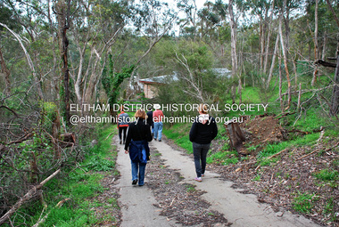
Photograph - Digital Photograph, Jim Connor, River Bend House, 130 Laughing Waters Road, Eltham, 7 September 2013
Laughing Waters Walk, 7 Sep 2013 This Society excursion was a follow up to the Laughing Waters Story told to us by Jane Woollard at our Annual General Meeting in March 2013. It involved a walk commencing from the corner of Laughing Waters and Overbank Roads along Laughing Waters Road to its eastern end and returning partly over the same route - a total distance of about 2.5km. On the way we visited the two artist in residence properties, River Bend and Birrarung, to view the houses on them that are associated with Alistair Knox, Gordon Ford and others in the local mud brick and artistic community. We also able to walk around the derelict ruin which was once home to Gordon and Sue Ford, Boomerang House. An unexpected afternoon tea was offered to us by the artists in residence at Birrarung House and we had a brief opportunity to view inside the house. River Bend was designed and built by Alistair Knox for Rosemary and Bill Cuming in 1968. It sits in a deep cutting on a steep slope above the Yarra River and features floor to ceiling windows and glass doors set into mission brown timber frames and walls of reclaimed bricks in pinkish hue. Rosemary laid the brick paving around the house, a copy of the shell paving found in the ancient French town of Colmar, where the family had lived for a period. The kitchen was equipped with a 1960s stove as well as a cast iron wood stove reclaimed from Rosemary's sister's home in Armadale. Max and Tini Huygens, migrants from Holland, purchased the property in 1975 and named it Tilwinda from an Aboriginal word meaning 'hole in a rock'. In late 1981 Tini died after a short illness, but Max continued to live at Tilwinda until he moved to a retirement village in 2000 and the property was sold to Parks Victoria. Renamed River Bend, the property became part of the Laughing Waters Artist in Residency Program in 2008. Nillumbik Shire Council upgraded the property in 2012 with solar panels, a heat pump for hot water and double glazing to improve the comfort of the artists in residence and make the house more energy efficient. For a more in-depth description of the property and biographies of the various artists in residence commencing from 2008 to 2015, see Jane Woollard's book, "Laughing Waters Road; Art, Landscape & Memory in Eltham" published 2016.2013-09-07, activities, artists in residence, eltham district historical society, heritage excursion, jim connor collection, laughing waters road, river bend house -
 Eltham District Historical Society Inc
Photograph - Digital Photograph, Jim Connor, Boomerang House, 195 Laughing Waters Road, Eltham, 7 September 2013
Laughing Waters Walk, 7 Sep 2013 This Society excursion was a follow up to the Laughing Waters Story told to us by Jane Woollard at our Annual General Meeting in March 2013. It involved a walk commencing from the corner of Laughing Waters and Overbank Roads along Laughing Waters Road to its eastern end and returning partly over the same route - a total distance of about 2.5km. On the way we visited the two artist in residence properties, River Bend and Birrarung, to view the houses on them that are associated with Alistair Knox, Gordon Ford and others in the local mud brick and artistic community. We also able to walk around the derelict ruin which was once home to Gordon and Sue Ford, Boomerang House. An unexpected afternoon tea was offered to us by the artists in residence at Birrarung House and we had a brief opportunity to view inside the house. Gordon Ford and photographer Sue Winslow were married in 1965. They set up home in an old log cabin on the property Gordon had purchased in 1954 on Laughing Waters Road. Situated between the Yarra River and Overbank Road, Gordon had built a small mud-brick shack on the river and a pontoon. Over the decades the shack has been locally referred to as “the love shack”, the “rooting shack” or simply “Gordon’s shack”. Gordon and Sue commissioned local builder Graeme Rose to do a wattle and daub renovation and extension to the old log cabin on the north side of Laughing Waters Road. The work had only just been completed in 1965 when a bushfire swept through the area and destroyed the cabin. Gordon and Sue relocated to his property, Fulling, in Pitt Street, Eltham. In 1970 work started on a new house at the Laughing Waters property. Originally known as the Banana House, it is now known as Boomerang. Designed by Alistair Knox, the mud-brick house includes iron window grilles made by Matcham Skipper that puncture the curved mud walls. The grilles were made from ‘off-pressings’ from the Sidchrome tool works in Heidelberg. Gordon, Sue and family moved into the house in 1972. Their marriage fell apart and Sue moved to Sydney with the children around the same time Gordon commenced building Birrarung just below Boomerang on the Laughing Waters Road block. After the Fords moved out, Boomerang it was rented out to various share households of students, musicians, artists and environmentalists for twenty-four years. Gordon Ford sold Birrarung and Boomerang to Melbourne Water in 1999. The Laughing Waters Artist in Residence Program was developed as a partnership between Parks Victoria and Nillumbik Shire Council. Boomerang was deemed unfit for habitation so was used as a day studio only. By 2001 Boomerang was in a poor state of repair and by 2002 the last artist in residence was to use the house as a studio. Nillumbik Shire Council had been granted funds from the Melbourne Community Fund to restore both Boomerang and Birrarung but it was apparent in early 2003 that the funds would be insufficient to restore both houses. Boomerang was infested with termites which presented a risk to any occupants and so the decision was made to close Boomerang and concentrate funding on Birrarung. Boomerang was fenced off for safety and to prevent intrusion and remains ‘caged’ today (2023). However, it is readily apparent the property has been occupied by squatters over the years. By 2023 it was clear that the squatters had abandoned the property and sections of the roof structure have given away in some areas and collapsed internally. For a more in-depth description and history of the property and that of Gordon and Sue Ford, see Jane Woollard's book, "Laughing Waters Road; Art, Landscape & Memory in Eltham" published 2016.2013-09-07, activities, eltham district historical society, heritage excursion, jim connor collection, laughing waters road, boomerang house, gordon ford -
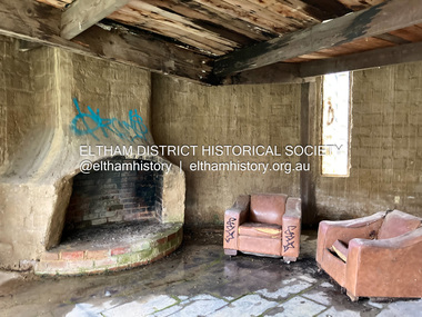 Eltham District Historical Society Inc
Photograph - Digital Photograph, Jim Connor, Fireplace, Boomerang House, 195 Laughing Waters Road, Eltham, 31 August 2021
Gordon Ford and photographer Sue Winslow were married in 1965. They set up home in an old log cabin on the property Gordon had purchased in 1954 on Laughing Waters Road. Situated between the Yarra River and Overbank Road, Gordon had built a small mud-brick shack on the river and a pontoon. Over the decades the shack has been locally referred to as “the love shack”, the “rooting shack” or simply “Gordon’s shack”. Gordon and Sue commissioned local builder Graeme Rose to do a wattle and daub renovation and extension to the old log cabin on the north side of Laughing Waters Road. The work had only just been completed in 1965 when a bushfire swept through the area and destroyed the cabin. Gordon and Sue relocated to his property, Fulling, in Pitt Street, Eltham. In 1970 work started on a new house at the Laughing Waters property. Originally known as the Banana House, it is now known as Boomerang. Designed by Alistair Knox, the mud-brick house includes iron window grilles made by Matcham Skipper that puncture the curved mud walls. The grilles were made from ‘off-pressings’ from the Sidchrome tool works in Heidelberg. Gordon, Sue and family moved into the house in 1972. Their marriage fell apart and Sue moved to Sydney with the children around the same time Gordon commenced building Birrarung just below Boomerang on the Laughing Waters Road block. After the Fords moved out, Boomerang it was rented out to various share households of students, musicians, artists and environmentalists for twenty-four years. Gordon Ford sold Birrarung and Boomerang to Melbourne Water in 1999. The Laughing Waters Artist in Residence Program was developed as a partnership between Parks Victoria and Nillumbik Shire Council. Boomerang was deemed unfit for habitation so was used as a day studio only. By 2001 Boomerang was in a poor state of repair and by 2002 the last artist in residence was to use the house as a studio. Nillumbik Shire Council had been granted funds from the Melbourne Community Fund to restore both Boomerang and Birrarung but it was apparent in early 2003 that the funds would be insufficient to restore both houses. Boomerang was infested with termites which presented a risk to any occupants and so the decision was made to close Boomerang and concentrate funding on Birrarung. Boomerang was fenced off for safety and to prevent intrusion and remains ‘caged’ today (2023). However, it is readily apparent the property has been occupied by squatters over the years. By 2023 it was clear that the squatters had abandoned the property and sections of the roof structure have given away in some areas and collapsed internally. For a more in-depth description and history of the property and that of Gordon and Sue Ford, see Jane Woollard's book, "Laughing Waters Road; Art, Landscape & Memory in Eltham" published 2016.jim connor collection, laughing waters road, boomerang house, gordon ford -
 Eltham District Historical Society Inc
Photograph - Digital Photograph, Jim Connor, The Love Shack, 195 Laughing Waters Road, Eltham, 7 September 2013
Laughing Waters Walk, 7 Sep 2013 This Society excursion was a follow up to the Laughing Waters Story told to us by Jane Woollard at our Annual General Meeting in March 2013. It involved a walk commencing from the corner of Laughing Waters and Overbank Roads along Laughing Waters Road to its eastern end and returning partly over the same route - a total distance of about 2.5km. On the way we visited the two artist in residence properties, River Bend and Birrarung, to view the houses on them that are associated with Alistair Knox, Gordon Ford and others in the local mud brick and artistic community. We also able to walk around the derelict ruin which was once home to Gordon and Sue Ford, Boomerang House. An unexpected afternoon tea was offered to us by the artists in residence at Birrarung House and we had a brief opportunity to view inside the house. Gordon Ford and photographer Sue Winslow were married in 1965. They set up home in an old log cabin on the property Gordon had purchased in 1954 on Laughing Waters Road. Situated between the Yarra River and Overbank Road, Gordon had built a small mud-brick shack on the river and a pontoon. Over the decades the shack has been locally referred to as “the love shack”, the “rooting shack” or simply “Gordon’s shack”. Gordon and Sue commissioned local builder Graeme Rose to do a wattle and daub renovation and extension to the old log cabin on the north side of Laughing Waters Road. The work had only just been completed in 1965 when a bushfire swept through the area and destroyed the cabin. Gordon and Sue relocated to his property, Fulling, in Pitt Street, Eltham. In 1970 work started on a new house at the Laughing Waters property. Originally known as the Banana House, it is now known as Boomerang. Designed by Alistair Knox, the mud-brick house includes iron window grilles made by Matcham Skipper that puncture the curved mud walls. The grilles were made from ‘off-pressings’ from the Sidchrome tool works in Heidelberg. Gordon, Sue and family moved into the house in 1972. Their marriage fell apart and Sue moved to Sydney with the children around the same time Gordon commenced building Birrarung just below Boomerang on the Laughing Waters Road block. After the Fords moved out, Boomerang it was rented out to various share households of students, musicians, artists and environmentalists for twenty-four years. Gordon Ford sold Birrarung and Boomerang to Melbourne Water in 1999. The Laughing Waters Artist in Residence Program was developed as a partnership between Parks Victoria and Nillumbik Shire Council. Boomerang was deemed unfit for habitation so was used as a day studio only. By 2001 Boomerang was in a poor state of repair and by 2002 the last artist in residence was to use the house as a studio. Nillumbik Shire Council had been granted funds from the Melbourne Community Fund to restore both Boomerang and Birrarung but it was apparent in early 2003 that the funds would be insufficient to restore both houses. Boomerang was infested with termites which presented a risk to any occupants and so the decision was made to close Boomerang and concentrate funding on Birrarung. Boomerang was fenced off for safety and to prevent intrusion and remains ‘caged’ today (2023). However, it is readily apparent the property has been occupied by squatters over the years. By 2023 it was clear that the squatters had abandoned the property and sections of the roof structure have given away in some areas and collapsed internally. For a more in-depth description and history of the property and that of Gordon and Sue Ford, see Jane Woollard's book, "Laughing Waters Road; Art, Landscape & Memory in Eltham" published 2016.2013-09-07, activities, eltham district historical society, heritage excursion, jim connor collection, laughing waters road, boomerang house, gordon ford, gordon's shack, love shack -
 Eltham District Historical Society Inc
Photograph, Fay Bridge, The Love Shack, 195 Laughing Waters Road, Eltham, April 2016
Gordon Ford built this shack on the Yarra at Laughing Waters Road. Bernie Bragg used to live there for a period of time. Gordon Ford and photographer Sue Winslow were married in 1965. They set up home in an old log cabin on the property Gordon had purchased in 1954 on Laughing Waters Road. Situated between the Yarra River and Overbank Road, Gordon had built a small mud-brick shack on the river and a pontoon. Over the decades the shack has been locally referred to as “the love shack”, the “rooting shack” or simply “Gordon’s shack”. Gordon and Sue commissioned local builder Graeme Rose to do a wattle and daub renovation and extension to the old log cabin on the north side of Laughing Waters Road. The work had only just been completed in 1965 when a bushfire swept through the area and destroyed the cabin. Gordon and Sue relocated to his property, Fulling, in Pitt Street, Eltham. In 1970 work started on a new house at the Laughing Waters property. Originally known as the Banana House, it is now known as Boomerang. Designed by Alistair Knox, the mud-brick house includes iron window grilles made by Matcham Skipper that puncture the curved mud walls. The grilles were made from ‘off-pressings’ from the Sidchrome tool works in Heidelberg. Gordon, Sue and family moved into the house in 1972. Their marriage fell apart and Sue moved to Sydney with the children around the same time Gordon commenced building Birrarung just below Boomerang on the Laughing Waters Road block. After the Fords moved out, Boomerang it was rented out to various share households of students, musicians, artists and environmentalists for twenty-four years. Gordon Ford sold Birrarung and Boomerang to Melbourne Water in 1999. The Laughing Waters Artist in Residence Program was developed as a partnership between Parks Victoria and Nillumbik Shire Council. Boomerang was deemed unfit for habitation so was used as a day studio only. By 2001 Boomerang was in a poor state of repair and by 2002 the last artist in residence was to use the house as a studio. Nillumbik Shire Council had been granted funds from the Melbourne Community Fund to restore both Boomerang and Birrarung but it was apparent in early 2003 that the funds would be insufficient to restore both houses. Boomerang was infested with termites which presented a risk to any occupants and so the decision was made to close Boomerang and concentrate funding on Birrarung. Boomerang was fenced off for safety and to prevent intrusion and remains ‘caged’ today (2023). However, it is readily apparent the property has been occupied by squatters over the years. By 2023 it was clear that the squatters had abandoned the property and sections of the roof structure have given away in some areas and collapsed internally. For a more in-depth description and history of the property and that of Gordon and Sue Ford, see Jane Woollard's book, "Laughing Waters Road; Art, Landscape & Memory in Eltham" published 2016.fay bridge collection, 2016-04, bernie's hut, birrarung, gordon ford, gordon's shack, laughing waters road, love shack, yarra river -
 Eltham District Historical Society Inc
Photograph, Fay Bridge, The Love Shack, 195 Laughing Waters Road, Eltham, 22 July 2016
Gordon Ford built this shack on the Yarra at Laughing Waters Road. Bernie Bragg used to live there for a period of time. Gordon Ford and photographer Sue Winslow were married in 1965. They set up home in an old log cabin on the property Gordon had purchased in 1954 on Laughing Waters Road. Situated between the Yarra River and Overbank Road, Gordon had built a small mud-brick shack on the river and a pontoon. Over the decades the shack has been locally referred to as “the love shack”, the “rooting shack” or simply “Gordon’s shack”. Gordon and Sue commissioned local builder Graeme Rose to do a wattle and daub renovation and extension to the old log cabin on the north side of Laughing Waters Road. The work had only just been completed in 1965 when a bushfire swept through the area and destroyed the cabin. Gordon and Sue relocated to his property, Fulling, in Pitt Street, Eltham. In 1970 work started on a new house at the Laughing Waters property. Originally known as the Banana House, it is now known as Boomerang. Designed by Alistair Knox, the mud-brick house includes iron window grilles made by Matcham Skipper that puncture the curved mud walls. The grilles were made from ‘off-pressings’ from the Sidchrome tool works in Heidelberg. Gordon, Sue and family moved into the house in 1972. Their marriage fell apart and Sue moved to Sydney with the children around the same time Gordon commenced building Birrarung just below Boomerang on the Laughing Waters Road block. After the Fords moved out, Boomerang it was rented out to various share households of students, musicians, artists and environmentalists for twenty-four years. Gordon Ford sold Birrarung and Boomerang to Melbourne Water in 1999. The Laughing Waters Artist in Residence Program was developed as a partnership between Parks Victoria and Nillumbik Shire Council. Boomerang was deemed unfit for habitation so was used as a day studio only. By 2001 Boomerang was in a poor state of repair and by 2002 the last artist in residence was to use the house as a studio. Nillumbik Shire Council had been granted funds from the Melbourne Community Fund to restore both Boomerang and Birrarung but it was apparent in early 2003 that the funds would be insufficient to restore both houses. Boomerang was infested with termites which presented a risk to any occupants and so the decision was made to close Boomerang and concentrate funding on Birrarung. Boomerang was fenced off for safety and to prevent intrusion and remains ‘caged’ today (2023). However, it is readily apparent the property has been occupied by squatters over the years. By 2023 it was clear that the squatters had abandoned the property and sections of the roof structure have given away in some areas and collapsed internally. For a more in-depth description and history of the property and that of Gordon and Sue Ford, see Jane Woollard's book, "Laughing Waters Road; Art, Landscape & Memory in Eltham" published 2016.fay bridge collection, 2016-07-22, bernie's hut, birrarung, gordon ford, gordon's shack, laughing waters, laughing waters road, love shack, yarra river -
 Eltham District Historical Society Inc
Photograph, Fay Bridge, Former Glynn's Dairy Farm, Glynns Road, North Warrandyte, 31 August 2018
Glynn’s farm Originally Section 7, Parish of Nillumbik marked Aborigine Reserve in 1866 Crown Allotment 8, Section 7, Parish of Nillumbik, County of Evelyn, Certificate of Title Volume 4095, Folio 818.835, approx. 93 acres purchased by Joseph Panton in 1881 for £1/acre and known as Panton’s Point. By 1924 owned by S.S. Sergeant and called Riverswood. Sergeant commissioned Edna Walling to design the garden. In September 1929 the property was sold at auction by Mortgagee’s sale. Described as well built, brick, tile roof, Attic Villa containing downstairs 7 good rooms, bath, scullery, inside lavatory, etc. Upstairs 2 bedrooms and sleep out. Outbuildings compromising of brick and weatherboard wash house, stables, workshop, feed room, cow bails, large G.I. Hay shed, etc In January 1931 Riverswood property was proclaimed a sanctuary for native game for the entire year. A private swing bridge crossed the river at Pound Bend was known as Pearson’s bridge after C.W.K. Pearson who bought Riverswood in the early 1930s. The bridge was swept away in the December 1934 floods. Riverswood was sold by C.W.K. Pearson at auction on 25 November 1936. Described as a beautiful farm home of 93 acres and over one mile of River Yarra frontage, modern brick residence, lovely garden, rich river flat pastures, model poultry farm. The fine brick home was destroyed on Black Friday (13 Jan.) 1939. It was still a ruin when the Evelyn Evans purchased Waikowhane above Riverswood in 1940. The Glynn family purchased the Riverswood property in 1941 from Robert and Emily Hannon. Their son Kenneth Patrick Glynn inherited the property and he set about clearing the land during WW2 selling wood. Prior to marriage, Kenneth was living alone on the farm in a house he had built from whatever was available. He used the bluestone foundations from the original fine brick home. He met and married Honora Elizabeth Drew in early 1945 and their daughter Anna grew up on the farm. It was compulsorily acquired by the Board of Works in 1976 who then rented the house out in the 1980s. The property was transferred to Melbourne Parks and Waterways in 1996. Waikowhane was a pretty timber house built on top of the hill on 50 acres above Riverswood by retired nurse Jessie MacBeth. (This would be at the intersection of Glynns Road and Overbank Road where the big water tank is now situated on what was once James Orford’s property.) It was also destroyed Black Friday and she rebuilt it from the plans living in a caravan on site supervising the build. It was almost complete when she died May 1939. The property was bought by Evelyn Evans (a city girl) and her estranged husband in 1940. She had two sons, one only 9 months old at the time. It was a timber house with no power or water connected. The Ewen Cameron family bought Waikowhane in 1957. They had to evacuate when the 1961 bushfires swept through. The house was saved by Matcham Skipper. It was demolished by Melbourne Water in the 1990s when they acquired it.fay bridge collection, 2018-08-31, glynn's, glynn's dairy farm, glynns road, north warrandyte, parks victoria, ruins, riverswood, kenneth patrick glynn -
 Eltham District Historical Society Inc
Document - Folder, Survey Maps and Technical Drawings
alan gardiner collection, maps