Showing 473 items
matching water works
-
 Melbourne Water
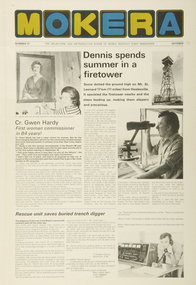
Staff Newsletter, Gwen Hardy, First Woman Commissioner, October, 1975
As the Yarra became unsuitable as a source of water, several attempts were made to find alternative sources for the growing population of Melbourne. It was not until 1891 that the efforts to sewer Melbourne came to fruition with the setting up of the Melbourne Metropolitan Board of Works (MMBW), now known as Melbourne Water. From 1891 until 1992, it was the responsibility of the MMBW to safeguard public health by providing a sewerage system and a safe water supply system. In 1992, The MMBW merged with a number of smaller urban water authorities to form Melbourne Water. Born on the 5th of August,1926, Margaret Gwen Hardy was the very first Commissioner of the Melbourne Metropolitan Board of Works (MMBW) and was appointed in 1975, a major victory for women at the time. This was the first time in the 84 year history of the organisation. Hardy had also been a Lilydale Councillor and went on to become the first female Shire President. Along with her work commitments as part of the Board, Hardy was the wife of Dr. Bill and had three children, two sons and a daughter. Next door to her home in Mt Evelyn was her husband’s surgery, where Hardy also worked part-time as a Manager. Hardy was also involved with the Lilydale High School Mother’s Club, she was the President of the Mt. Evelyn Environment Protection and Progress Association, on the Advisory Council of Monbulk High School and was the Secretary of the Lilydale Citizens Advisory Service at the time. This staff newsletter highlights the historically significant achievement of Cr. Gwen Hardy becoming the first female commissioner to work at the Board in 84 years. This captured achievement highlights women's career advancement at the MMBW and within the Victorian public service, whilst having historic and social associations with the many women's rights movements in the 1970s.comissioner, melbourne water, mmbw, melbourne metropolitan board of works, woman, staff, newsletter -
 Melbourne Water
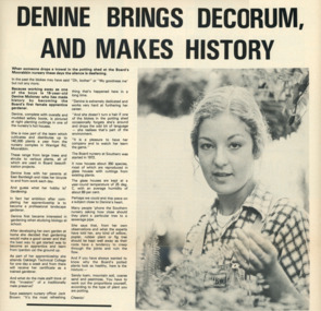
Staff Newsletter, Denine Moloney, First Female Apprentice Gardener, 1979
As the Yarra became unsuitable as a source of water, several attempts were made to find alternative sources for the growing population of Melbourne. It was not until 1891 that the efforts to sewer Melbourne came to fruition with the setting up of the Melbourne Metropolitan Board of Works (MMBW), now known as Melbourne Water. From 1891 until 1992, it was the responsibility of the MMBW to safeguard public health by providing a sewerage system and a safe water supply system. In 1992, The MMBW merged with a number of smaller urban water authorities to form Melbourne Water. Denine Moloney made history at the MMBW as the Board’s first female apprentice gardener, at the young age of 16. Denine was part of a team that cultivated and distributed up to 140,000 plants a year from the nursery complex that was housed on Warrigal Road, in Moorabbin. The large trees, shrubs and various other plants were all used in Board beautification projects. At the time, Denine lived with her parents and rode her bicycle to and from work each day while she attended Oakleigh Technical College one day a week as part of her apprenticeship. Denine’s ambition was to become a professional landscape gardener after her apprenticeship was completed, and four years later was in fact appointed as head gardener at Jells Park in 1983. Denine was not the last woman to work as a gardener at the Board, bringing with her two female assistants at Jells Park in caring, maintaining and distributing the Board’s horticulture. This staff newsletter highlights the significant achievement of Denine Moloney, becoming the first female gardener to work at the Board. This captured achievement highlights women's career advancement at the MMBW and within the Victorian public service, whilst having historic and social associations with the many women's rights movements of the 1970s.gardener, woman, melbourne metropolitan board of works, mmbw, staff, newsletter, 1970s -
 Melbourne Water
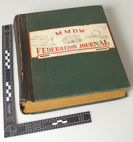
MMBW Federation Journal, October 1942 to May 1946
As the Yarra became unsuitable as a source of water, several attempts were made to find alternative sources for the growing population of Melbourne. It was not until 1891 that the efforts to sewer Melbourne came to fruition with the setting up of the Melbourne Metropolitan Board of Works (MMBW), now known as Melbourne Water. From 1891 until 1992, it was the responsibility of the MMBW to safeguard public health by providing a sewerage system and a safe water supply system. In 1992, The MMBW merged with a number of smaller urban water authorities to form Melbourne Water.Formally titled, The Official Organ of the Melbourne and Metropolitan Board of Works Employees’ Federation, this series is an exhaustive collection of monthly articles published by MMBW staff. This voluminous collection highlights the accomplishments and social agenda of MMBW employees throughout WWII and its impact on the organisation.mmbw, melbourne metropolitan board of works, journal, articles, staff, 1940s -
 Melbourne Water
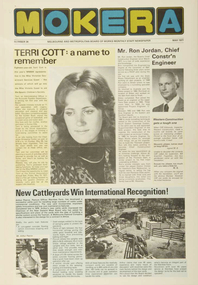
Staff Newsletter, Miss MMBW, Terri Cott, 1977
As the Yarra became unsuitable as a source of water, several attempts were made to find alternative sources for the growing population of Melbourne. It was not until 1891 that the efforts to sewer Melbourne came to fruition with the setting up of the Melbourne Metropolitan Board of Works (MMBW), now known as Melbourne Water. From 1891 until 1992, it was the responsibility of the MMBW to safeguard public health by providing a sewerage system and a safe water supply system. In 1992, The MMBW merged with a number of smaller urban water authorities to form Melbourne Water. The Australian Cerebral Palsy Association ran the Miss Australia Quest and had various titles such as Miss Queensland and Miss Victoria. One branch of the Victorian state competition was the Miss Victorian Government Service Quest. Terri Cott was one of the MMBW’s most popular representatives in the running for the title of Miss Victorian Government Service Quest in 1977. At the time, 18 year old Terri was an Administrative Officer in the Accounts Payable Department and had been with the Board for a year. Terri was crowned as the winner for Miss Victorian Government Service as she was the second highest money raiser with $17,337.72. This also won her a holiday on Brampton Island. Terri was up against 12 other women from other state Government Departments.This staff newsletter highlights the historically significant achievement of Miss Terri Cott being one of the most popular representatives in the running for the title of Miss Victorian Government Service Quest in 1977. This captured achievement not only focuses on Terri's external beauty, but demonstrates her charitable efforts. This newsletter article has historic and social associations with the many women's rights movements in the 1970s. In particular, it relates to the number of challenges the Miss Australia Quest experienced with feminist and activist groups threatening the future of the competition, which forced organisers to examine the appropriateness of the Quest. mmbw, melbourne water, miss mmbw, 1970s, staff -
 Melbourne Water
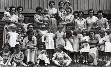
Photograph, Upper Yarra Dam Personnel, 1955
As the Yarra became unsuitable as a source of water, several attempts were made to find alternative sources for the growing population of Melbourne. It was not until 1891 that the efforts to sewer Melbourne came to fruition with the setting up of the Melbourne Metropolitan Board of Works (MMBW), now known as Melbourne Water. From 1891 until 1992, it was the responsibility of the MMBW to safeguard public health by providing a sewerage system and a safe water supply system. In 1992, The MMBW merged with a number of smaller urban water authorities to form Melbourne Water. In 1946, the Melbourne and Metropolitan Board of Works (MMBW) approved a site for a new dam for Melbourne's domestic water. This is now known as the Upper Yarra Dam. Due to the construction of the dam, the workforce had to be accommodated on site; domestic quarters were built for single men, families and staff. The township also had kitchens, laundry facilities, a canteen, a recreation hall, mess areas and a co-op store, with one of the first houses being seconded to accommodate for a school. This photograph shows personnel at a Kindergarten party at the Upper Yarra Dam, a time where workers were housed during its construction. The photograph is historically significant as it captures a purpose built community that supported the workers undertaking the construction of the dam. upper yarra dam, mmbw, melbourne metropolitan board of works, township, 1940s, community -
 Melbourne Water
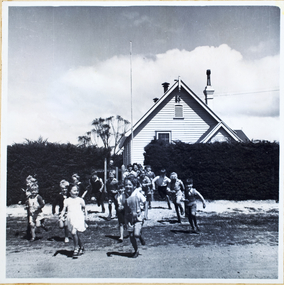
Photograph, North Cocoroc State Primary School, 1950s
... melbourne metropolitan board of works melbourne water North Cocoroc ...As the Yarra became unsuitable as a source of water, several attempts were made to find alternative sources for the growing population of Melbourne. It was not until 1891 that the efforts to sewer Melbourne came to fruition with the setting up of the Melbourne Metropolitan Board of Works (MMBW), now known as Melbourne Water. From 1891 until 1992, it was the responsibility of the MMBW to safeguard public health by providing a sewerage system and a safe water supply system. In 1992, The MMBW merged with a number of smaller urban water authorities to form Melbourne Water. The township of Cocoroc was created in 1894 at the Metropolitan Sewage Farm (now the Western Treatment Plant) to house the workers it employed. The name 'Cocoroc' means 'frog' in the language of the Wathaurung people — the Traditional Owners of the land the treatment plant was built on. By the early 1950s there were nearly 100 houses, a town hall, football ground (and team), swimming pool, tennis courts, four schools and a post office, and by the 1970s some 500 people were living in Cocoroc. As it became too expensive for the MMBW to subsidise, Cocoroc was abandoned. By 1973 most of the houses and other buildings were demolished or moved to Werribee. All that is left now of Cocoroc are two small, empty, concrete swimming pools, a few weatherboard sheds and a big iron water tank. This photograph detailing an exterior view of the North Cocoroc State Primary School, is historically significant as it captures children at play within a purpose built community. The School that was one of four was built to educate the children of the MMBW workers. As the school no longer exists, this photograph is the only tangible evidence left of the building, also showcasing the style of buildings in this era. cocoroc, township, school, mmbw, melbourne metropolitan board of works, melbourne water -
 Melbourne Water
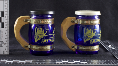
Souvenir Salt and Pepper Shakers, 1970s
The Maroondah System was first and foremost developed as a functional component of Melbourne's Water Supply System. In addition to functionality, the Melbourne and Metropolitan Board of Works (MMBW) envisioned the Maroondah Reserve to be enjoyed aesthetically and recreationally by the public. This souvenir illustrates the realisation of the Maroondah System as a local recreational and tourist attraction in the early 20th century. The Maroondah Reserve gardens were landscaped with English-style ornamental stonework, exotic trees, flower beds and rose gardens. All features of the water supply system became widely celebrated as beauty spots that continue to be very popular to this day with tourists and locals alike. This souvenir is a product of that flourishing tourist trade. These water supply sites continue to enhance Melbourne’s charm and liveability and are now recognised as places of cultural and historic significance.These souvenir salt and pepper shakers have been curated by Melbourne Water as they represent an important historical aspect of the organisation by demonstrating the popularity of its water asset sites as recreational places and tourist attractions, and although these sites are functional parts of the water supply system, they were also designed to be enjoyed by the public both aesthetically and recreationally. Additionally, the salt and pepper shakers are aesthetically pleasing as the blue glass and wooden handles demonstrate the design and style of the 1970s. These souvenir salt and pepper shakers feature glass bodies, wooden handles and plastic lids. The salt and pepper shakers are decorated with pictures of koalas, kangaroos and a map of Australia. The text “Maroondah Dam, Vic” has been inscribed on the wooden handles.melbourne metropolitan board of works, mmbw, maroondah, salt and pepper shakers, souvenir, glass, healesville -
 Melbourne Water
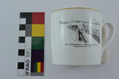
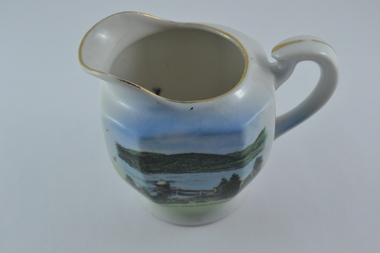
Souvenir Tea Cup, 1920s
... Melbourne Water 990 La Trobe Street Docklands melbourne ...The Maroondah System was first and foremost developed as a functional component of Melbourne's Water Supply System. In addition to functionality, the Melbourne and Metropolitan Board of Works (MMBW) envisioned the Maroondah Reserve to be enjoyed aesthetically and recreationally by the public. This souvenir illustrates the realisation of the Maroondah System as a local recreational and tourist attraction in the early 20th century. The Maroondah Reserve gardens were landscaped with English-style ornamental stonework, exotic trees, flower beds and rose gardens. All features of the water supply system became widely celebrated as beauty spots that continue to be very popular to this day with tourists and locals alike. This souvenir is a product of that flourishing tourist trade. These water supply sites continue to enhance Melbourne’s charm and liveability and are now recognised as places of cultural and historic significance.This souvenir tea cup has been curated by Melbourne Water as it represents an important historical aspect of the organisation by demonstrating the popularity of its water asset sites as recreational places and tourist attractions, and although these sites are functional parts of the water supply system, they were also designed to be enjoyed by the public both aesthetically and recreationally. Additionally, the tea cup is aesthetically pleasing, representative of 1920s style and design. This porcelain tea cup with gold trim features a black and white image of the embankment at Maroondah Dam, Healesville on the front.melbourne metropolitan board of works, melbourne water, mmbw, porcelain, tea cup, maroondah, healesville -
 Melbourne Water
Souvenir Porcelain Milk Jug, 1910-1930
The Maroondah System was first and foremost developed as a functional component of Melbourne's Water Supply System. In addition to functionality, the Melbourne and Metropolitan Board of Works (MMBW) envisioned the Maroondah Reserve to be enjoyed aesthetically and recreationally by the public. This souvenir illustrates the realisation of the Maroondah System as a local recreational and tourist attraction in the early 20th century. The Maroondah Reserve gardens were landscaped with English-style ornamental stonework, exotic trees, flower beds and rose gardens. All features of the water supply system became widely celebrated as beauty spots that continue to be very popular to this day with tourists and locals alike. This souvenir is a product of that flourishing tourist trade. These water supply sites continue to enhance Melbourne’s charm and liveability and are now recognised as places of cultural and historic significance.This souvenir milk jug has been curated by Melbourne Water as it represents an important historical aspect of the organisation by demonstrating the popularity of its water asset sites as recreational places and tourist attractions, and although these sites are functional parts of the water supply system, they were also designed to be enjoyed by the public both aesthetically and recreationally. Additionally, this item is aesthetically significant as it represents the style and design of the early 1900s.This souvenir white-glazed porcelain milk jug features gold trim and an illustration of the Maroondah Outlet in the centre, with the transfer “Maroondah Dam, Healesville, Vic”. -
 Melbourne Water
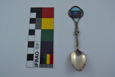
Souvenir Spoon
The Maroondah System was first and foremost developed as a functional component of Melbourne's Water Supply System. In addition to functionality, the Melbourne and Metropolitan Board of Works (MMBW) envisioned the Maroondah Reserve to be enjoyed aesthetically and recreationally by the public. This souvenir illustrates the realisation of the Maroondah System as a local recreational and tourist attraction in the early 20th century. The Maroondah Reserve gardens were landscaped with English-style ornamental stonework, exotic trees, flower beds and rose gardens. All features of the water supply system became widely celebrated as beauty spots that continue to be very popular to this day with tourists and locals alike. This souvenir is a product of that flourishing tourist trade. These water supply sites continue to enhance Melbourne’s charm and liveability and are now recognised as places of cultural and historic significance.This souvenir spoon has been curated by Melbourne Water as it represents an important historical aspect of the organisation by demonstrating the popularity of its water asset sites as recreational places and tourist attractions, and although these sites are functional parts of the water supply system, they were also designed to be enjoyed by the public both aesthetically and recreationally.Manufactured in Australia, this souvenir silver-plated spoon features an image of Maroondah Dam, Healesville. The spoon features a koala engraving and boomerang on the stem. Engraved on the back of the spoon is “Peninsula Plate”.mmbw, melbourne metropolitan board of works, spoon, souvenir, maroondah, healesville, melbourne water -
 Melbourne Water
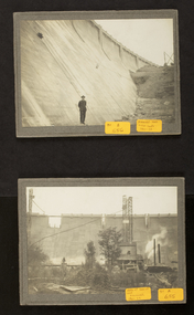
Photographs: The Maroondah Dam Wall Under Construction, 1921-1922
... Melbourne Water 990 La Trobe Street Docklands melbourne ...The Maroondah System was first and foremost developed as a functional component of Melbourne's Water Supply System. In addition to functionality, the Melbourne and Metropolitan Board of Works (MMBW) envisioned the Maroondah Reserve to be enjoyed aesthetically and recreationally by the public. This souvenir illustrates the realisation of the Maroondah System as a local recreational and tourist attraction in the early 20th century. The Maroondah Reserve gardens were landscaped with English-style ornamental stonework, exotic trees, flower beds and rose gardens. All features of the water supply system became widely celebrated as beauty spots that continue to be very popular to this day with tourists and locals alike. This souvenir is a product of that flourishing tourist trade. These water supply sites continue to enhance Melbourne’s charm and liveability and are now recognised as places of cultural and historic significanceThese photographs are invaluable in providing insight into many aspects of the Maroondah Reservoir’s early development. The dam wall is a distinctive example of early engineering techniques, with its gravity arch design and concrete construction. The construction of the dam wall represents an important advancement in the technology of dam-building.These images are part of a series of eight photographs which document the construction of the Maroondah Dam in the 1920s.melbourne metropolitan board of works, mmbw, melbourne water, photograph, water, maroondah dam, construction, wall -
 Melbourne Water
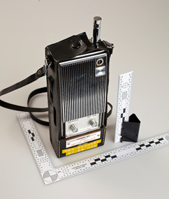
Toshiba Two-Way Handheld Radio, 1970s
... of works mmbw melbourne water radio technology field water Toshiba ...As the Yarra became unsuitable as a source of water, several attempts were made to find alternative sources for the growing population of Melbourne. It was not until 1891 that the efforts to sewer Melbourne came to fruition with the setting up of the Melbourne Metropolitan Board of Works (MMBW), now known as Melbourne Water. From 1891 until 1992, it was the responsibility of the MMBW to safeguard public health by providing a sewerage system and a safe water supply system. In 1992, The MMBW merged with a number of smaller urban water authorities to form Melbourne Water.This item is of historical signficance for its association with the former Melbourne and Metropolitan Board of Works (MMBW). Utilised by MMBW field staff, this is a perfectly intact object of standard Board issued equipment. The two-way hand held radio is signficant for its representativeness of the theme of Technology within the MMBW and Melbourne Water.melbourne metropolitan board of works, mmbw, melbourne water, radio, technology, field, water -
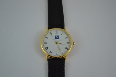 Melbourne Water
Melbourne Water Watch, 1996
... metropolitan board of works mmbw melbourne water watch accessory gift ...As the Yarra became unsuitable as a source of water, several attempts were made to find alternative sources for the growing population of Melbourne. It was not until 1891 that the efforts to sewer Melbourne came to fruition with the setting up of the Melbourne Metropolitan Board of Works (MMBW), now known as Melbourne Water. From 1891 until 1992, it was the responsibility of the MMBW to safeguard public health by providing a sewerage system and a safe water supply system. In 1992, The MMBW merged with a number of smaller urban water authorities to form Melbourne Water. This Melbourne Water watch was gifted to a Melbourne Water staff member by her manager when she left the organisation in 1996. The watch was part of a branding campaign as the water industry became segregated in 1994.This item is of historical significance for its association with Melbourne Water at the time when the water industry became segregated in 1994. This watch is a perfectly intact object and is significant for its representativeness of the theme of Women in the Workforce within the MMBW and Melbourne Water as it was gifted to a female employee. The watch is also aesthetically pleasing in style and represents the trends of the 1990s. Gold plated, black leather band watch with the Melbourne Water logo on the face with accompanying black suede case with gold corners. The watch also comes with a warranty inside.melbourne metropolitan board of works, mmbw, melbourne water, watch, accessory, gift -
 Melbourne Water
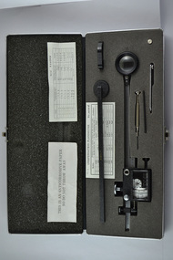
Compensating Polar Planimeter, c.1970s
As the Yarra became unsuitable as a source of water, several attempts were made to find alternative sources for the growing population of Melbourne. It was not until 1891 that the efforts to sewer Melbourne came to fruition with the setting up of the Melbourne Metropolitan Board of Works (MMBW), now known as Melbourne Water. From 1891 until 1992, it was the responsibility of the MMBW to safeguard public health by providing a sewerage system and a safe water supply system. In 1992, The MMBW merged with a number of smaller urban water authorities to form Melbourne Water. This item was used by MMBW employees as a measuring device to determine areas or figures on a plane surface having either straight or irregular boundaries. The Compensating Polar Planimeter is of historical significance for its association with the former Melbourne and Metropolitan Board of Works (MMBW). This measuring device is perfectly intact and a rare surviving object of standard Board issued equipment. The kit is significant for its representativeness of the theme of Technology in building Victoria's industries and workforce, which continues to resonate strongly within Melbourne Water today.The instrument is inside a black metal case with accessories including: Setting bar, screwdriver, Allen key and spare pole point. Inside is also the adjustable planimeter. mmbw, melbourne water, melbourne metropolitan board of works, technology, instrument, work, measure, historic, water, staff -
 Melbourne Water
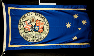
Melbourne and Metropolitan Board of Works Flag
As the Yarra became unsuitable as a source of water, several attempts were made to find alternative sources for the growing population of Melbourne. It was not until 1891 that the efforts to sewer Melbourne came to fruition with the setting up of the Melbourne Metropolitan Board of Works (MMBW), now known as Melbourne Water. From 1891 until 1992, it was the responsibility of the MMBW to safeguard public health by providing a sewerage system and a safe water supply system. In 1992, The MMBW merged with a number of smaller urban water authorities to form Melbourne WaterThis MMBW flag is of historical significance for its association with the former Melbourne and Metropolitan Board of Works (MMBW). This flag is relatively intact with only two of its kind held in the collection. The flag is significant as is represents a proud organisation and demonstrates the organisations historical development of services, a strong theme of the collection. The flags navy and gold colour is aesthetically pleasing while the coat of arms represented on the flag holds great meaning. Navy and gold Melbourne Metropolitan Board of Works (MMBW) flag with the Southern Cross and MMBW coat of arms. The coat of arms incorporates Melbourne and the United Kingdom, and the motto of the board 'Publica Merces Salus Mea', 'Public Health is my Reward'. mmbw, melbourne water, flag, coat of arms, proud, textile -
 Melbourne Water
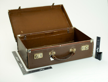
MMBW briefcase, c.1950s
... melbourne metropolitan board of works melbourne water briefcase ...As the Yarra became unsuitable as a source of water, several attempts were made to find alternative sources for the growing population of Melbourne. It was not until 1891 that the efforts to sewer Melbourne came to fruition with the setting up of the Melbourne Metropolitan Board of Works (MMBW), now known as Melbourne Water. From 1891 until 1992, it was the responsibility of the MMBW to safeguard public health by providing a sewerage system and a safe water supply system. In 1992, The MMBW merged with a number of smaller urban water authorities to form Melbourne Water.This MMBW briefcase is of historical significance for its association with the former Melbourne and Metropolitan Board of Works (MMBW). This item is perfectly intact and a rare surviving object of standard Board issued accessories. The briefcase is significant for its representativeness of the theme Staff and in building Victoria's industries and workforce, which continues to resonate strongly within Melbourne Water today. The style of this briefcase also demonstrates early 19th century design. MMBW brown leather briefcase with MMBW gold embossed on the lid.mmbw, melbourne metropolitan board of works, melbourne water, briefcase, staff, people, work, water supply -
 Melbourne Water
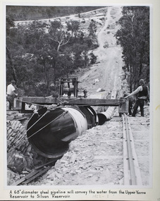
Photograph - Steel Pipeline, 1952
... melbourne metropolitan board of works melbourne water Upper Yarra ...The Upper Yarra Reservoir supplies the Silvan Reservoir, which distributes water throughout the Melbourne metropolitan area. The dam was completed in 1957 and is a rolled earthfill and rockfill embankment. This photograph shows a 68" diameter steel pipeline that was to convey the water from the Upper Yarra Reservoir to the Silvan Reservoir.This photograph is significant as it provides a detailed insight into the Boards activity and construction of one of Melbourne's most important water supply systems. Furthermore, it is of historical importance to the history of Melbourne while it is representative of shaping Melbourne's environments, transforming and managing land and natural resources, and providing urban infrastructure and services. The photograph itself is aesthetically pleasing, through its depth of field and use of shape with an interesting composition. Black and white photographmmbw, melbourne metropolitan board of works, melbourne water, upper yarra reservoir, silvan reservoir, water, waterway, dam -
 Melbourne Water
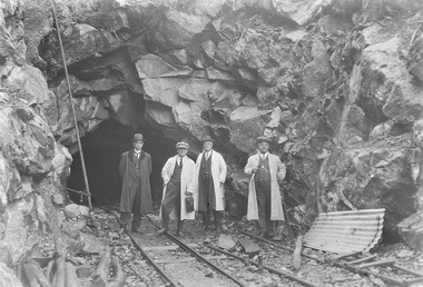
Photograph - Tunnel at the O'Shannasy Dam, 9th April 1921
... of Melbourne's most important water supply systems. Furthermore ...The O'Shannassy Reservoir supplies water to the Silvan Reservoir, which distributes it to most parts of Melbourne. The dam was completed in 1928 and is an earthfill embankment with a reinforced concrete core wall.This photograph is significant as it provides a detailed insight into the Boards activity and construction of one of Melbourne's most important water supply systems. Furthermore, it is of historical importance to the history of Melbourne while it is representative of shaping Melbourne's environments, transforming and managing land and natural resources, and providing urban infrastructure and services. This photograph also covers the theme of Safety, depicting the safety standards of the time particularly with clothing. Black and white photographmmbw, melbourne metropolitan board of works, melbourne water, silvan reservoir, o'shannassy reservoir, construction, work, men, infrastructure -
 Melbourne Water
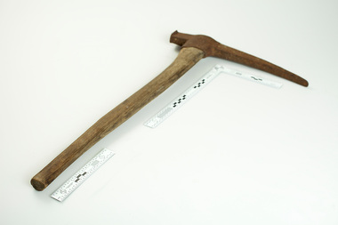
MMBW Hand Tool "Pick"
As the Yarra became unsuitable as a source of water, several attempts were made to find alternative sources for the growing population of Melbourne. It was not until 1891 that the efforts to sewer Melbourne came to fruition with the setting up of the Melbourne Metropolitan Board of Works (MMBW), now known as Melbourne Water. From 1891 until 1992, it was the responsibility of the MMBW to safeguard public health by providing a sewerage system and a safe water supply system. In 1992, The MMBW merged with a number of smaller urban water authorities to form Melbourne Water.This hand tool is of historical significance for its association with the former Melbourne and Metropolitan Board of Works (MMBW). This tool is a rare surviving object of standard Board issued equipment. It is significant for its representativeness of the theme of Technology in building Victoria's industries and workforce, which continues to resonate strongly within Melbourne Water today.MMBW hand tool, "Pick" with wooden handle and 'MMBW 'stamped on the metal head.melbourne water, mmbw, melbourne metropolitan board of works, pick axe, construction, work, staff, equipment, technology -
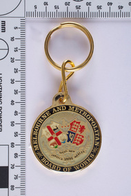 Melbourne Water... of works souvenir melbourne water coat of arms proud seal ...As the Yarra became unsuitable as a source of water, several attempts were made to find alternative sources for the growing population of Melbourne. It was not until 1891 that the efforts to sewer Melbourne came to fruition with the setting up of the Melbourne Metropolitan Board of Works (MMBW), now known as Melbourne Water. From 1891 until 1992, it was the responsibility of the MMBW to safeguard public health by providing a sewerage system and a safe water supply system. In 1992, The MMBW merged with a number of smaller urban water authorities to form Melbourne Water. The seal incorporates the coat of arms of Melbourne and the United Kingdom, and the motto of the board 'Publica Merces Salus Mea', 'Public Health is my Reward'. Text around the circular edge and in banners below two shields. The banners have leaves entwined. Above the two shields there is a kangaroo in profile beneath sun rays. One shield is part of the Coat of Arms of Melbourne and has a hanging fleece (top left quadrant), whale (top right quadrant), a bull (lower left quadrant) and a three-masted ship (lower right quadrant). The other shield is part of the Coat of Arms of the United Kingdom and has three lions passant (top left and lower right quadrants) representing England, a lion rampant (top right quadrant) representing Scotland and a harp (lower left quadrant) representing Ireland. This MMBW key ring is of historical significance for its association with the former Melbourne and Metropolitan Board of Works (MMBW). The key ring is in a perfect condition and is significant as is represents a proud organisation and represents the organisations historical development of services, a strong theme of the collection. The key ring is aesthetically pleasing while the coat of arms holds great meaning. Gold key ring with the MMBW seal. mmbw, melbourne metropolitan board of works, souvenir, melbourne water, coat of arms, proud, seal, organisation
 -
 Melbourne Water
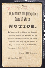
MMBW Notice, 6th November 1903
... . melbourne water mmbw melbourne metropolitan board of works notice ...As the Yarra became unsuitable as a source of water, several attempts were made to find alternative sources for the growing population of Melbourne. It was not until 1891 that the efforts to sewer Melbourne came to fruition with the setting up of the Melbourne Metropolitan Board of Works (MMBW), now known as Melbourne Water. From 1891 until 1992, it was the responsibility of the MMBW to safeguard public health by providing a sewerage system and a safe water supply system. In 1992, The MMBW merged with a number of smaller urban water authorities to form Melbourne Water.This MMBW notice is of historical significance for its association with the former Melbourne and Metropolitan Board of Works (MMBW). This item fits under the theme of staff/employees at the MMBW. The Melbourne and Metropolitan Board of Works Notice by direction of the Officers and Servants' Committee,Officers and Employees of the Board are notified that they must not absent themselves from duty for the purpose of taking part in Parliamentary, Municipal, or other Elections. GEO. A. Gibbs, Secretary. melbourne water, mmbw, melbourne metropolitan board of works, notice, work, water -
 Bendigo Historical Society Inc.
Document - CONNELLY, TATCHELL, DUNLOP COLLECTION: LEGAL PAPERS, 1880's
Document. Connelly, Tatchell & Dunlop. 1 - 1880's - Document dealing with the Loddon Shire Trust and Serpentine Estate concerning damages done by Water Trust in constructing drain works, channels, weir building etc on Serpentine Estate. Contains statements by:- Raleigh Joseph - Sheep Farmer 'Tandarra'; Coutts George - Farmer & Grazier Fernihurst; Coutts David - Grazier; Stewart James Symes - Arbitrator and Auctioneer at Talbot; Moylan Mr W - Water Bailiff; Southern George Bell - Inspector of Works; McIvor John - Grazier & Farmer; Bryant Henry - Farmer & Contractor; Fleming George - Farmer & Grazier; Carter Samuel - Sheep Breeder & Squatter; Roberts Edmund Jas - Hay & Corn Merchant South Melbourne; Young George - Stock & Station Agent Ballarat; De Caris Elisha Clement - Wesleyan Minister; Starr John Gardner - Engineer to Water Trust; McKay Robert - Clerk in Office Mining Engineer; Manning James - Actuary.cottage, miners, connelly, tatchell & dunlop, loddon shire trust, serpentine estate, raleigh j, coutts geo, coutts d, stewart j s, moylan mr w, southern g b, mcivor j, bryant h, fleming geo, carter s, roberts e j, young g, de caris e c, starr j g, mckay r, manning j -
 Bendigo Historical Society Inc.
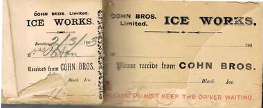
Document - COHN BROTHERS COLLECTION: RECEIPT BOOK FOR ICE SALES, 2/3/1903 - 1908
Document. Cohn Bros. Collection. Partly used receipt book for Cohn Bros. Ltd Ice Works. Has names of customers.organization, business, cohn bros, cohn bros. collection, brewers, cordial & aerated water manufacturers, ice sales -
 Yarra City Council
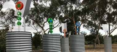
Artwork, other - Installation/Sculpture, Troy Innocent, Joel Collins, Indae Hwang, Yun Tae Nam, Drop Zone, 2011
'Drop Zone', is set in an imagined future where decreasing water availability has affected us more dramatically than anyone predicted. The water shortage has become so severe that we have to access water on a first-come first-serve basis, from military-like water ‘drop zones’, like this one, made from modified rain water tanks. These tanks function on three levels: Collected rain water causes the totem sculptures to rise and bloom; evaporation causes the totem sculptures to fall; and an anemometer (device that measures wind speed) drives a process that plays the tank like a giant drum, tuned by the amount of water contained within. This artwork envisions a future for Australia where the impact of decreasing water availability has had a more dramatic effect than any of the predictions. The shortage is so severe that military-like water ‘drop zones’, constructed of modified rainfall storage tanks have been established across the public parks of the City of Yarra for access on a first come, first serve basis. However, as the water is only replenished through rain catchment the tanks may only offer infrequent relief for the City of Yarra residents, standing as hollow reminders of the effects of inaction on the shaping of sustainable national water use.'Drop Zone' was one of three public art works installed in Yarra, in 2011, under the banner of The Environmental Public Arts Project which responded to key features of Council's Environment Strategy: 'Towards Local Sustainability 2008-2020.' The aims of this project included activating public spaces in new and creative ways through the creation of artworks which act as catalysts for further engagement and discussion around environmental themes and issues.Copyright the Artists. Ready-made corrugated water tanks arranged on a site. Situated within the tanks are small totemic sculptures that float on top of the water within the tank.Accompanying plaquesustainability, water, environment, climate change -
 Bendigo Historical Society Inc.
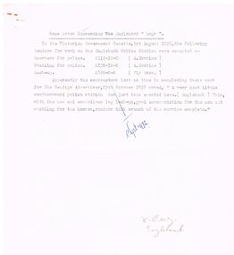
Document - RESEARCH NOTES: ONE TREE HILL, STORMWATER CHANNEL, ANTHONY TROILLOPE, HORSE TRAMWAY TO GOLDEN SQUARE
Typed and handwritten notes. Mentioned are: - Some Notes Concerning The Eaglehawk Logs, Damaging the Stormwater Channel, where some Chinese were digging away the Creek, the cutting down of the giant gum tree which gave One Tree Hill its name, How Anthony Trollope saw Bendigo in the 1870's, A Proposed Horse Tramway to Golden Square, Society’s' Trip to Bridgewater Flour Mill, A talk on a trip to Malaya by Mr D Hester, Society News and Happenings, Old Bendigonians and Safety Cages,document, various notes, eaglehawk logs, bendigo advertiser 19/10/1858, damaging the stormwater channel, bendigo advertiser 11/8/1872, harneys bridge, gas works, constable rogers, constable james bradley, joch, john o'c hattam, one tree hill, ryan, trollope's fabulous bendigo, anthony trollope, 'trollope’s australia', nelson press, alex h stone, bendigo advertiser 5/7/1897, mr peter ellis, cr hoskins, horse tramway, historical society, water wheel flour mill, june parry, mr pat wodetzki, mr leo wodetzki, neil murray, mr k hester, mr wes harry, mr i hendry, mr henry jackson, mr connelly, mr irons, mr harney, dr smith, dr hoyle, rev dr bachaus, rev dr nish, rev joseph dare, hon angus mackay, mr haverfield, mr j k robshaw, w p neal, mr george lansell, hon j h abbott, m l c, mr j casey, dr james boyd, dr atkinson, dr easie, mr t h henderson, old beehive, francis brothers, mr john crowley, mr jacob cohn, art gallery, mr hugh mcdevitt, mr alexander bayne, mr f sciallero, camp reserve, hon w i winter-irvine, mr george avery fletcher, great central goldfield of victoria, safety cages, bendigo advertiser, j h seymour, mr horwood, new chum and victoria tribute company, james watson, seymour's patent safety cage, londerry tribute, national show sandhurst, h banfield, mr a llewllyn, 'dear old bendigo', thomas bracken, mr william heffernan, mr edward (ned) ryan, mr samuel bastard, mr charles bird, mcpherson and co, fern hill club, mr george tolhurst, tolhurst brothers, union bank, mr lawrence ryan, mr shadrack jones, charley armstrong, armstrong brothers, mr abraham solomen, mr bladiere mr r t wheeler -
 National Vietnam Veterans Museum (NVVM)
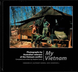
Book, Lewis, Stephen, My Vietnam: Photograph by Australian eterans of the Vietnam conflict. (Copy 2)
My Vietnam is a pictorial journey seen through the cameras of over 80 Australian veterans of the Vietnam conflict.The book is signed by the author. The dustjacket is missing & the hard cover of the book is damaged along the edges & the top of the pages appears water damaged.My Vietnam is a pictorial journey seen through the cameras of over 80 Australian veterans of the Vietnam conflict. 1961-1975 - participation, australian, vietnam war, 1961- 1975 - pictorial works, australian national serviceman, nui dat, 12th field regiment, royal australian artillery -
 National Vietnam Veterans Museum (NVVM)
Book, Lewis, Stephen, My Vietnam: Photograph by Australian veterans of the Vietnam conflict. (Copy 1), 2002
My Vietnam is a pictoria journey seen through the cameras of over 80 Australian veterans of the Vietnam conflict.The book is signed by the author. The dustjacket is missing & the hard cover of the book is damaged along the edges & the top of the pages appears water damaged.My Vietnam is a pictoria journey seen through the cameras of over 80 Australian veterans of the Vietnam conflict. 1961-1975 - participation, australian, vietnam war, 1961- 1975 - pictorial works, australian national serviceman, 12th field regiment, royal australian artillery -
 Wannon Water
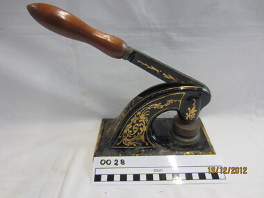
Cast iron seal embossing press, Excello, Seal
Heywood Waterworks Trust was constituted on 20 November 1962 upon application by Councillors of the Shire of Portland to construct, manage and maintain the works for the supply of water to the township of Heywood. The Trust was abolished on 1 July 1984 under the Water and Sewerage (Restructuring) Act 1983 when it amalgamated with the Heywood Sewerage Authority to form Heywood Water BoardA cast iron seal press, . This was used by Heywood Waterworks Trust to emboss agreements and official documents. Die is still attached to the press. It reads: Heywood Waterworks Trust 1963Small metal machine painted black and mounted onto a black rubber base. Two dies are attached with the seal of Heywood Waterworks Trust. Paper is placed between the dies, the handle depressed and the seal embossed on the paper under pressure as a blind (inkless) embossing. The seal consists of two circles with the wording "Heywood Waterworks Trust".Heywood Waterworks Trust 1963/ Excello / Reg Trade Mark/ Seal Press/ Pat NO 420419/Size No 2/Inscription on rubber base: "EXCELLO SEAL PRESS" / REGD TRADE MARK / 1. PATENT ROLLER BEARING HANDLE PAT. NO. 420419 / 2. DURABLE PLASTIC COUNTER / 3. RUBBER DESK PROTECTOR / STANDARD RUBBER TYPE CO. LTD. / TOKYO JAPAN"heywood, public administration, water supply, amalgamations -
 Wannon Water
Cast Iron Seal Embossing Press, Seal
Mortlake Waterworks Trust – 18 May 1915 to 1 July 1984 Mortlake Waterworks Trust was constituted on 18 May 1915 following application by the Shire of Mortlake to carry out works for the supply of water to the township of Mortlake. The Trust was abolished on 1 July 1984 under the Water and Sewerage Authorities (Restructuring) Act 1983 when authority was transferred to the Mortlake Water Board. A cast iron seal press. This was used by Mortlake Waterworks Trust to emboss agreements and official documents. Die is still attached to the press. It reads: Mortlake Waterworks Trust 1915. Small metal machine painted black , decorated gold . Dies are attached with the seal of Mortlake Waterworks Trust . Paper is placed between the dies, the handle depressed and the seal embossed on the paper under pressure as a blind (inkless) embossing. The seal consists of two circles with the wording "Mortlake Waterworks Trust 1915". Mortlake Waterworks Trust 1915mortlake, public administration, water supply, amalgamations -
 Wannon Water
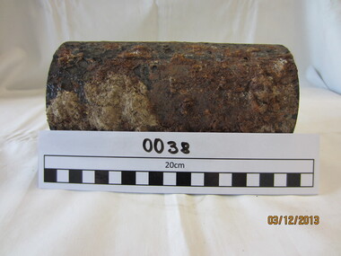
Pipe, Cast Iron Pipe
... of Jamieson Street Roundabout Pipe Works in 2013 Water Pipe ...This 75 mm cast iron pipe was laid in 1920 and would have been cement lined in the 1960's. It was replaced during modifications of Jamieson Street Roundabout Pipe Works in 2013Cast Iron pipe - rust encrusted on the outside, cement lined on the insidewater, pipe, reticulation,