Showing 9285 items
matching street name
-
 Surrey Hills Historical Society Collection
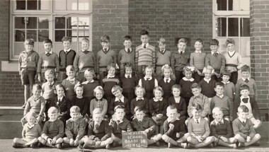
Photograph, Mont Albert Central School Grade 1B, 1953
Mont Albert State School was officially opened on 23rd April 1917. The school became Mont Albert Central School in 1918, taking in Forms 1 and 2. The school remained a Central School until 1964, when the secondary years formed the basis of a new High School, the Box Hill North High School, later to be named Koonung Secondary College. This is part of a large collection of material related to the Deakin, Mair and Young families, all with connections to Surrey Hills and Mont Albert. Laurie Young was the daughter of Beryl Mair (1916-1976) and Ernest Lance Young (1915-1999). The family lived at 5 York Street and later 11 York Street, Mont Albert. Laurie was born on 18 August 1947. Black and white class photo taken outside the school building. The class of 14 girls and 29 boys. Not all children are wearing school uniform."LY" in grey lead pencil in top RH corner. This probably stands for Laurie Young. Photographer's identification stamp in black ink " L.E. REYNOLDS / PHOTOGRAPHER / 38 RUSSELL STREET, / SURREY HILLS, E10"mont albert central school, laurie young, laurie newton, education -
 Surrey Hills Historical Society Collection
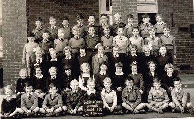
Photograph, Mont Albert Central School Grade 2B, 1954
Mont Albert State School was officially opened on 23rd April 1917. The school became Mont Albert Central School in 1918, taking in Forms 1 and 2. The school remained a Central School until 1964, when the secondary years formed the basis of a new High School, the Box Hill North High School, later to be named Koonung Secondary College. This is part of a large collection of material related to the Deakin, Mair and Young families, all with connections to Surrey Hills and Mont Albert. Laurie Young was the daughter of Beryl Mair (1916-1976) and Ernest Lance Young (1915-1999). The family lived at 5 York Street and later 11 York Street, Mont Albert. Laurie was born on 18 August 1947. Black and white class photo taken outside the school building. The class of 19 girls and 29 boys. Not all children are wearing school uniform."Laurie" in grey lead pencil in top LH corner. This probably stands for Laurie Young. Photographer's identification stamp in faint purple ink " L.E. Reynolds / PHOTOGRAPHER / 38 RUSSELL STREET, / SURREY HILLS, E10"mont albert central school, laurie young, laurie newton, education -
 Surrey Hills Historical Society Collection
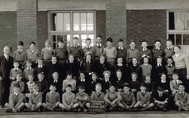
Photograph, Mont Albert Central School Grade 3R, 1955
Mont Albert State School was officially opened on 23rd April 1917. The school became Mont Albert Central School in 1918, taking in Forms 1 and 2. The school remained a Central School until 1964, when the secondary years formed the basis of a new High School, the Box Hill North High School, later to be named Koonung Secondary College. As Laurie was in the photo of Class 2B, this photo may include one of her siblings. This is part of a large collection of material related to the Deakin, Mair and Young families, all with connections to Surrey Hills and Mont Albert. Laurie Young was the daughter of Beryl Mair (1916-1976) and Ernest Lance Young (1915-1999). The family lived at 5 York Street and later 11 York Street, Mont Albert. Laurie was born on 18 August 1947. Black and white class photo taken outside the school building. The class of 20 girls and 29 boys. Not all children are wearing school uniform. The children are flanked by an older gentleman wearing glasses (left facing) and a younger woman (right facing).Photographer's identification stamp in black ink " L.E. Reynolds / PHOTOGRAPHER / 35 RUSSELL STREET, / SURREY HILLS, E10"mont albert central school, laurie young, laurie newton, education -
 Surrey Hills Historical Society Collection
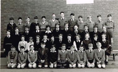
Photograph, Mont Albert Central School Grade 6M, 1958
Mont Albert State School was officially opened on 23rd April 1917. The school became Mont Albert Central School in 1918, taking in Forms 1 and 2. The school remained a Central School until 1964, when the secondary years formed the basis of a new High School, the Box Hill North High School, later to be named Koonung Secondary College. This is part of a large collection of material related to the Deakin, Mair and Young families, all with connections to Surrey Hills and Mont Albert. Laurie Young was the daughter of Beryl Mair (1916-1976) and Ernest Lance Young (1915-1999). The family lived at 5 York Street and later 11 York Street, Mont Albert. Laurie was born on 18 August 1947. Black and white class photo taken outside the school building. The class of 22 girls and 22 boys. Not all children are wearing school uniform."Laurie Young" in black ink in top LH corner. "Pupils of GRADE 6 MOLISER. / Of Mont AlbERT CENtERl / School" (?) in black ink.mont albert central school, laurie young, laurie newton, education -
 Surrey Hills Historical Society Collection
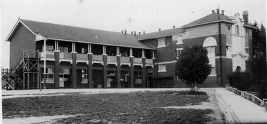
Photograph, Laurie Newton (nee Young), Mont Albert Central School, c1956, 1956
Mont Albert State School was officially opened on 23rd April 1917. The school became Mont Albert Central School in 1918, taking in Forms 1 and 2. The school remained a Central School until 1964, when the secondary years formed the basis of a new High School, the Box Hill North High School, later to be named Koonung Secondary College. This is part of a large collection of material related to the Deakin, Mair and Young families, all with connections to Surrey Hills and Mont Albert. Laurie Young was the daughter of Beryl Mair (1916-1976) and Ernest Lance Young (1915-1999). The family lived at 5 York Street and later 11 York Street, Mont Albert. Laurie was born on 18 August 1947. Black and white photo taken of the school building from the path from Barloa Street. There is one large bush to the left of the path obscuring the side of the main building. There is a wooden fire escape at the far end of the building. The grass in the foreground is patchy."School" underlined in blue ink, centre top. "MOnT ALBeRT CENTAL / School" centre in blue biro; thought to be the donor's hand. "GRADE" in blue ink "IV D" in blue ink. "APPROX: 1958" in blue biro; thought to be the donor's hand. These have been written by at least 2 hands and at different times.mont albert central school, laurie young, laurie newton, education -
 Surrey Hills Historical Society Collection
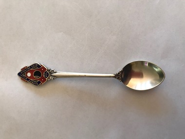
Souvenir - Souvenir teaspoon, Twentieth Century
James Albon is credited with building the first bowling green in Surrey Hills at his home on the corner of Mont Albert Road and Wilson Street (later occupied by the Roman Catholic convent). This green was so popular with his friends that he organised the formation of a bowling club at the corner of Montrose and Wilson Streets. It opened in 1912. Earliest club records date from 1916. The original club-house was rebuilt in 1922/23 using interlocking blocks as recommended by Walter Burley-Griffin. This was quite an innovative design at the time. In turn cream brick buildings replaced this building in the 1950s. The Surrey Hills Bowls Club disbanded in 1995. The donor believed that this spoon belong to her grandfather David Miller (Dave) Mair who lived at 20 Barton Street until his death in 1938. Dave was an extremely keen sportsman (particularly bowls and cricket). He started the Kangaroo Cricket Club and worked for the Melbourne Cricket Club. She initially sent the spoon to the Surrey Hills Bowling Club in 1996, not realising that it had closed the previous year. It was returned to her and over 20 years later was donated to this collection. This is part of a large donation of material relating to the Deakin, Mair and Young families, all with connections to the Surrey Hills and Mont Albert area. This augments other material relating to the history of the Surrey Hills Bowling Club that was saved by Jocelyn and Ken Hall after the club closed in 1995. The official records of the club were deposited with the State Library of Victoria, but prior to this some summary notes were made by the Halls. The material is evidence of one of the earliest sporting clubs established in the area.An EPNS metal teaspoon, consisting of a curved bowl with a decorative plaque at the top of the handle. On the front of this is an image of a lawn bowls ball and a jack within a scroll and linked with a band containing the words "SURREY HILLS BOWLING CLUB VIC". The plaque is inlaid in red, navy, white and black enamel. The makers name is impressed into the back of the handle.Rear: "Paramount" / "E.P.N.S."surrey hills bowling club, souvenir spoons, david miller mair, dave mair, laurie young, laurie newton -
 Surrey Hills Historical Society Collection
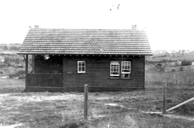
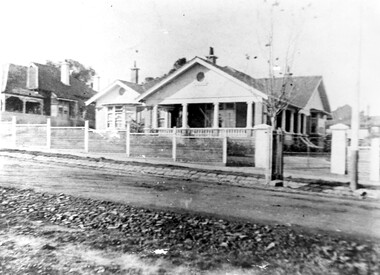
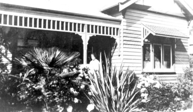
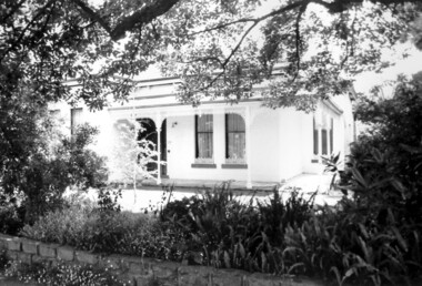
Photograph - Mrs Long's house, Delta Street area, Surrey Hills
The property is in the area that later became Delta Street, on the north side of Back Creek. Once roads were made and streets numbered, this became 1 Delta Road, Surrey Hills. Part of the undeveloped land would become part of South Surrey Park. According to Alan Holt's property register the house was built in c1920 and was demolished after having been neglected in 1991. He records it having had various names: 'Westward Ho', 'Pembroke' and 'The Oaks'. The first owner from 1920 was Eric Rowland Handyside Long who married Agnes May Hay Murray in March 1920. They had one son James Murray Long, born in September 1921. They divorced in 1937 and thereafter the property is listed in the name of Mrs Mary Hay Long, James M Long or Miss Mary Hay Long. According to Alan Holt, the house featured in the television series 'Carson's Law' in c1984.This is one of relatively few photos which record the transformation of rural land into the suburb that became Surrey Hills.A simple dark-stained timber house with a veranda and tiled roof. It is simply fenced with posts and wire mess. There are other houses in the background but part of the area remains as open space.delta road, back creek, south surrey park, wetward ho, pembroke, the oaks, hose names, miss agnes may hay murray, mrs agnes may hay long, mrs mary hay long, miss mary hay long, james murray long, carson's law -
 Surrey Hills Historical Society Collection
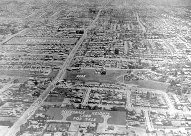
Photograph - Aerial view Riversdale Heights Estate area, c1923
... -divided post WW1, hence the naming of the streets after sites ...This was probably part of a real estate promotion for the sale of the Riversdale Heights Estate. This was subdivided by Messrs. Duncan and Weller. Of the allotments offered, 30 were sold and realised £4600. Date of this sale was c December 1923. This suggests that the date This are was one of the last pieces of former rural land to be sub-divided for housing in Surrey Hills.The land between it and South Surrey Park was sub-divided post WW1, hence the naming of the streets after sites of WW1 battles.A black and white reproduction of an aerial photo of the area near the corner of Warragul and Riversdale Roads looking west towards the city. Some features have been identified by name including the Riversdale Heights Estate, which was being sub-divided. North and South Courts are shown. Other roads (unmarked) in the foreground are Graham Street, Allie Street, Thistle Street, Lille Street, Amiens Street, and Marne Street. Beyond these is the area marked 'PARK' (South Surrey Park), which is devoid of vegetation. Areas of Camberwell and Canterbury are also shown. The area covered extends to beyond St Dominic's Church. The original is mounted on a cream deckle-edged paper.Beneath the original on the mount: "SOUTH SURREY HILLS LOOKING WEST c. 1936" [The reference to the sale in the Box Hill Reporter of December 1923 found on Trove suggests that this date is not accurate.] Rear top LH corner of original in Jocelyn Hall's handwriting: "For Centre / from Mr James Long"riversdale heights estate, riversdale road, allie street, south surrey park, lille street, thistle street, amiens street, marne street, south court, north court, duncan and weller, real estate sales, graham street, st dominics church, highfield park, canterbury primary school, aerial photo -
 Surrey Hills Historical Society Collection
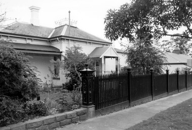
Photograph, 181 Union Road, home of Mr and Mrs Antonio Clota
The house was built in 1910. The Clota and Sans families were part of a group of families of Spanish (Catalan) background who lived around Surrey Hills, many of whom are buried in Box Hill Cemetery. The house was built for Antonio and Josepha Clota and passed on to their daughter Josephine Sans and her family. Antonio's full name: Antonio Eusebio Miquel CLota (1869-1940; died Surrey Hills) had 3 brothers who came to Australia with him. Louis Clota (1864-1925); Marcus Clota (1866-1940) died Surrey Hills; Eusebio Clota (1869-1919). Their parents remained in Spain. Josephine Clota and Kim Sans had photos taken on the front entrance to the house when they were married on 9 May 1919. The wedding was reported in Punch.Black and white photo of the home of Mr and Mrs Antonio Clota; later the home of their daughter Josephine and son-in-law, Kim Sans and family. It shows bluestone curb and channelling in Union Road and a substantial wire mesh fence. The street tree looks like a plane tree and is a relatively young plant. Ther house is single storey brick with a tile roof and solid pillars supporting the verandah.houses, antonio clota, josepha comellas, josepha clota, catalan families, josephine clota, josephine sans, kim sans, joaquim sans, francis clota, frank clota, box hill cemetery -
 Surrey Hills Historical Society Collection
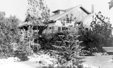
Photograph, 'Graceburn', 17 Trafalgar Street, Mont Albert
... at 9 Victoria Crescent. trafalgar street graceburn house names ...Joseph Arthur Bailey, described as a manager in electoral rolls, came to Surrey Hills some time before 1903. He was born in Brighton in 1873 and died in Burwood in 1929 and is buried in Box Hill Cemetery. He was the son of George Bailey and Georgina Hardwick, who lived in Healesville for a time but 'retired' to Surrey Hills where they are listed at 'Claremont' in Mont Albert Road in 1919. Joseph married Eleanor Beatrice Greenhill in 1897. They had 3 sons - Rupert Aitken (who served in WW1); Kenneth Alan and Edwin George. Prior to living in Trafalgar Street they lived at 9 Victoria Crescent. A black and white photograph of a brick house in the californian bungalow style with a well-established garden, as viewed from one side.trafalgar street, graceburn, house names, 1919, californian bungalow, box hill cemetery, joseph arthur bailey, mrs eleanor beatrice bailey, miss eleanor beatrice greenhill, mr rupert aitken bailey, mr kenneth alan bailey, mr edwin george bailey -
 Surrey Hills Historical Society Collection
Photograph, Baby Health Centre in the Surrey Gardens, 1982
The Baby Health Centre opened in the Surrey Gardens in 1930 on the site previously occupied by the screen for outdoor pictures. Previously during the 1920s it had operated in the room underneath the rotunda in the Surrey Gardens. The room was also shared by other groups including the Surrey Hills Progress Association (SHPA). The SHPA raised 200 pounds to provide the materials for the building, which was built by voluntary labour under the leadership of Ralph Hayes, a local builder. The foundation stone was laid by Mrs A Latham, Mayoress of Camberwell on 31 March 1930. There is a bottle containing the names of the committee members sealed in the pillar behind the memorial stone. The centre was managed by a committee until 1975. Maternal health nurses associated with the centre included Sister D Thompson, Sister Newnham, Sister Kelsell, Sister Barker, Sister Sharp and Sister Bolton. Ref: Mrs D Lancashire - a long-serving member of the committee. The site of the Surrey Hills Maternal and Child Health Centre was moved to 18 Verdun Street, adjacent to the pre-school, in accord with Council policy to co-locate services and from a concern regarding solo staff working in relatively isolated locations. The building was included in the heritage overlay protecting the gardens and was refurbished by Council for community use. The cairn commemorates the work of Cr Albert Ernest Vine who was a Camberwell Councillor from 1926-1934 and 1937-1944; he was also Mayor on 1940-41. There is a photo of him in Mayoral robes in the City of Boroondara Library Service collection.Black and white photo of a timber building with a tiled roof and a brick veranda supported by brick and concrete pillars. In front of the baby health centre is a small cairn.surrey gardens, baby health centres, monuments and memorials, surrey hills progress association, cr albert ernest vine, sister d thompson, sister d. newnham, sister kelsell, sister barker, sister sharp and sister bolton, mrs a latham, ralph hayes, mrs d lancashire -
 Surrey Hills Historical Society Collection
Work on paper - Photograph, Nethercourt Private Hospital, Surrey Hills, c 1924, 1924
Notes from a previous collection coordinator indicate that Miss Lucy Musselwhite (Lillywhite) opened the hospital in 1914 and Matron Eliza Tank took it over in 1921 and named it Nethercourt Private Hospital. However recent research suggests that Miss Musselwhite (name confirmed) moved from Tooronga to Wilson Street some time between 1903 and 1909. She and her mother Elizabeth are listed in the 1909 electoral rolls in Wilson Street and Lucy's occupation is given as nurse. (It is of course possible that the property was a residence only at this time and later opened as a private hospital.) The name Nethercourt was used prior to Matron Eliza Tank taking over. Her daughter Irene was also a nurse at Nethercourt. Lucy Musselwhite was born in 1873 in Hampshire. She married Henry James Dore in later life and lived in Brenbeal Street, Balwyn. She died in 1955. In 1930 / 1935 Matron Tank transferred the hospital to 219-223 Union Road. Later it was known as Norwich Hall / St Jude's. Mosgiel Hospital in Mont Albert Road also opened in 1924. After this time home births became less common. Nethercourt Hospital closed in the 1960s.Small hospitals such as this one were primarily used for midwifery, preceding the development of larger centralised general hospitals. Black and white photo of Nethercourt Private Hospital at 11 Wilson Street in c 1924 taken from the street in winter. The building is Victorian in style; block-fronted with lacework detail to the verandah and has 2 chimneys. It is set behind a wooden picket fence behind which is a well-manicured hedge which appears to have been grown across the front entrance gate.nethercourt private hospital, midwifery, hospitals, matron eliza tank, miss lucy musselwhite, miss irene tank, mrs irene anderson -
 Surrey Hills Historical Society Collection
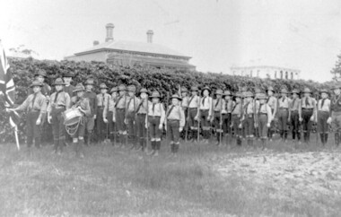
Photograph, 1st Surrey Hills Boy Scout Troop c. 1909-1912
1st Surrey Hills Boy Scout Troop was formed in 1909 by Theodore Hendy, two years after Lord Robert Baden-Powell had started the Movement. Hendy (left back) sent Baden-Powell greetings advising he was sending a photo of his troop. This could be the photograph. Taken in the grounds of his home "Kookaburra" (demolished) in Albany Crescent, Surrey Hills (later given the number 44). The Royal Hotel on the corner of Canterbury Road and Broughton Road can be seen on the right. The photograph was taken by M. Hill, uncle of Mr W. Dempsey. 'Kookaburra' was the home of Theodore Hendy's uncle Archibald Noete Hendy, an estate agent. Earlier it was known as 'Glastonbury'. In c1938 the house was demolished and the land divided into 4 lots. Archibald Hendy and his wife Bertha Bowen (nee Rohs) later resided at 'Barehin' in Pembroke Street. Black & white photo of 1st Surrey Hills Boy Scout Troop in the grounds of 'Kookaburra' (now demolished) in Albany Crescent Surrey Hills. In the background are 2 buildings. surrey hills scout troop, 1900-1909, 1910-1919, royal hotel, albany crescent, surrey hills, uniforms, hats, flags, clothing and dress, canterbury road, broughton road, house names, hotels, scout groups, youth clubs, (mr) w dempsey, (mr) m hill, (mr) theodore hendy, 'kookaburra' -
 Surrey Hills Historical Society Collection
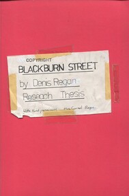
Book, Blackburn Street, ?1980s
A thesis prepared by Mr Denis Regan for a Home and Environment Study, on Surrey Hills, Blackburn Street, and in particular no. 3 Blackburn Street, built in 1920. Includes some photos and house prices.A thesis prepared by Mr Denis Regan for a Home and Environment Study, on Surrey Hills, Blackburn Street, and in particular no. 3 Blackburn Street, built in 1920. Includes some photos and house prices.surrey hills, blackburn street, (mr) denis regan, blackburn estate, elgar's special survey, (mr) fred hemingway oldis, houses, californian bungalow, (mr) william holland, house names, clevedon, (mrs) christina holland, (mrs) carmel regan, (mr) len lewis, (mrs) doreen lewis -
 Surrey Hills Historical Society Collection
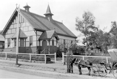
Photograph, Holy Trinity Church, Surrey Hills in the 1920s
This church was built in 1907 and became known as Holy Trinity Surrey Hills. This name had previously been used by the Anglican Church in Mont Albert Road, Mont Albert. This henceforth became known as St George's Anglican Church, Mont Albert. There are 2 copies: the original donated print and an enlargement. The original is mounted on card with photo mounts along with 890, 891 and 892. It measures 13 cm x 9 cm. Norman Carter took many photos of Surrey Hills and Mont Albert from the 1920s in particular of events and activities associated with the Church of England.Black and white photo of the original Holy Trinity Church building in Union Road. It is constructed of weatherboards, above which there is plasterboard and timber strapping. The roof is of terracotta tiles with a small steeple at the front and a larger one towards the rear of the building. There is a box bay window at the front and the entrance is from a porch on the southern side of the building. This is approached by stairs. Part of the vicarage can be seen on the northern high side of the church and to the south there is vacant land. The whole property sits behind a simple post and wire fence. There is a phaeton in the foreground beside a relatively newly planted street tree. The road has bluestone kerb and channelling.churches, holy trinity church, anglican church, horse-drawn vehicles, norman brodley carter, union road -
 Surrey Hills Historical Society Collection
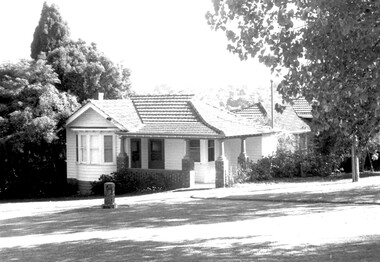
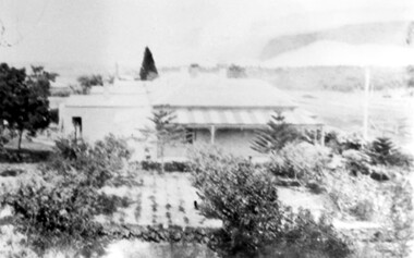
Photograph, 'Glenisla', 18 Chestnut Street, Surrey Hills, c 1920, 1920
Date is approximate. In 1920 this became the home of Mr and Mrs Robert Moore, whose daughter Mabel Annie married Norman Brodley Carter of Mont Albert. The house was named after 'Glenisla', a western District grazing property located between Hamilton and Horsham on the Henty Highway and on the edge of the Grampians National Park. This was established as a super-fine wool stud in 1860 and was passed down the family until it was sold in 1922. The family transferred from this property to Melbourne. Robert is listed as a grazier in the 1924 electoral roll at Chestnut Street. With him are Victor Cecil listed as a carpenter; Isabella, Mabel Annie and Edgar Gilbert listed as an orchardist. In 2003 the house was extant minus the verandas. This photo may have been taken from the rear of the property. Ref: History of original property - Age newspaper article: 'The Best - Glenisla: historic Grampians property', 7 January 1994. Moore family details: Robert Moore born 1857 on Isle of Man; died Surrey Hills 1940 Isabella Bateson born 1869; died Surrey Hills 1938 Married in 1894 in Miram, 10 km north-east of Kaniva in the northern Wimmera. All the children were born in Kaniva. Children: Lena Florence (1895-1980) Victor Cecil (1896-1984) - a builder Edgar Gilbert (1897-1976); died Surrey Hills; married Myrtle Emary, daughter of Henry John Emary of Surrey Hills Ernest Alan (1900-1900) Mabel Annie (1901-1957); died Surrey Hills married Norman Brodley Carter (1899-1984) Clarence Arthur (1904-2004). Norman Carter took many photos in the Surrey Hills and Mont Albert are from the 1920s; many is connection with Church of England events and activities. Robert and Isabella Moore are buried in Box Hill Cemetery. Black and white photo of a Victorian home with a veranda with a corrugated iron roof and lacework on 2 sides. It appears to have a later extension at the rear. It is surrounded by mature gardens with ornamental trees (cypresses) and an area with plants in rows, which may be a vegetable garden. There appears to be significant areas of open space around the house.glenisla, homes, victorian style, gardens, norman carter, robert moore, miss isabella bateson, mrs isabella moore, victor cecil moore, edgar gilbert moore, miss mabel annie moore, box hill cemetery -
 Surrey Hills Historical Society Collection
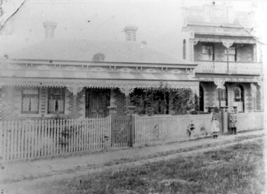
Photograph, 'Maitland', 1 Bedford Avenue, Surrey Hills, c 1900, 1900
Maitland' was built in 1889 for Thomas Zeplin, who was a Professor of Music. He owned all the land bound by Union Road, Wilson and Montrose Streets and the railway line. 1 Bedford Avenue stayed in family ownership until purchased by Camberwell Council in 1986, initially for a car park. However it was renovated to become part of Surrey Hills Neighbourhood Centre. It was opened on 23 November 1990. No 3 Bedford Avenue was built for Thomas Zeplin's daughter and named 'Mervyl' or 'Merryl'. Mrs Brodecky (donor) was the great-granddaughter of Thomas Zeplin. The 2 girls are granddaughters of Thomas Zeplin. Electoral roll information: 1972 & 1977: Albert Vojteck Brodecky, manager, 1 Bedford Avenue. 1977: Ray Nanette Brodecky. There are 2 copies. Thomas had this built for his son and family. The house was occupied by his family, though sometimes rented out. His great-grand-daughter Mrs. A. Brodecky sold to the Camberwell Council in 1986. This was the only surviving photo in the family after the fire. Courtesy: Mrs. A. BrodeckyBlack and white photo of 2 houses taken from the street front. On the LHS is a Victorian double-fronted single-storey villa of Hawthorn brick construction, with wrought iron lacework to the veranda, slate roof and picket fence, with an established garden. Next door at No 3 is a double-storey Victorian terrace with a similar fence and building materials. There are 2 young girls standing in front between the properties.maitland, bedford avenue, 1900, surrey hills neighbourhood centre, victorian style, mervyl, merryl, mr thomas zeplin, mrs nanette brodecky, mr albert vojteck brodecky -
 Surrey Hills Historical Society Collection
Photograph, Falconer family home, 'Legerton' at 15 Albert Crescent, 1920
Date is approximate. House was built in 1910 and has been demolished. The woman on the verandah is probably Mrs P Falconer, Ron Falconer's mother. Her full name was Emily Victoria Aird (1884-1957), daughter of James Bromich Aird and Sarah Ann (nee Edwards). She married Patrick Henry Falconer on 11 December 1907 in Blackburn. The Falconer family lived in Albert Crescent for many years. Listed in electoral rolls in 1916 through to the 1950s. By 1963 the family were at 33 Weybridge Street, Surrey Hills. Emily and Patrick Henry Falconer had 4 children: Ronald Keith (b1908); Hilda Irene (b 1910); Harold Leslie (b 1913) and Hilah (b 1915). James and Sarah Aird are buried in Box Hill Cemetery.Black and white photo showing a close-up view of the Falconer family home, 'Legerton' at 15 Albert Crescent, Surrey Hills with a woman at the entrance. It is a timber Edwardian home with simple fretwork on the verandah and a mature garden which partially obscures the entrance.edwardian style, legerton, albert crescent, miss emily victoria aird, mrs emily victoria falconer, patrick henry falconer, ronald keith falconer, miss hilda irene falconer, harold leslie falconer, hilah falconer -
 Surrey Hills Historical Society Collection
Photograph, "Ancyra" 25 Weybridge Street, Surrey Hills
... names weybridge street surrey hills whitehorse road james street ...John Butler Maling, retired farmer, built his home on the corner of his property which extended from Weybridge Street to Whitehorse Road and from James to Ross Street. From 1853 he lived in a simple farmhouse located near the present Ross Street until he had 'Ancyra' built in c.1889 from bricks made from clay dug from a quarry on the property. This was located in the now-park in James Street. John Butler Maling Snr was born in Shepreth, Cambridgeshire. He married Kate Conlan in 1882 and they had 3 children - Silas, Alick and Zillah. He died in 1912 and is buried in Box Hill Cemetery. Often referred to as John Butler Maling Senior as he had a nephew by the same name. He also lived on a similar sized property known as 'The Willows', located to the west. He became the first Mayor of Camberwell. From c1936 til c1960 the property was used as a rest home (Ancyra Rest Home) and then a nursery (Pied Piper Nursery).This property is important as one of few remaining extant links to pre-urban Surrey Hills, and built from local material.A black and white photograph of a brick house with a slate roof and corrugated iron over the verandah and portico. A picket fence painted a dark colour features decorative finals on the tops of the posts.ancyra, house names, weybridge street, surrey hills, whitehorse road, james street, ross street, john butler maling (snr), mrs kate maling, silas maling, alick maling, zillah maling, miss kate conlan, box hill cemetery, ancyra rest home, pied piper nursery -
 Surrey Hills Historical Society Collection
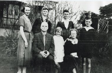
Photograph, Thomas Lothian, his wife Effie with their family, c. 1932
... lothian st abbs house names york street surrey hills lothian book ...Thomas Carlyle Lothian (1880-1974) was born on 7 May 1880 at Newcastle-upon-Tyne, England, eldest child of John Inglis Lothian, bookkeeper, and his wife Lillias Charlotte, née Smith. The family arrived in Melbourne in July 1888, John having come to represent the publishing firm of Walter Scott. His father started his own company in c1890. Thomas joined the business in c1897. In 1911 he established the Standard Publishing Co. Pty Ltd to sell the publications of the Caxton Press direct to the public. In 1912 he married Effie Marian Vines, who had worked for several years in his father's office. His father retired the same year and Thomas formed the company of Thomas C. Lothian Pty Ltd to carry on representing numerous well-known British and American publishers. However, he also published in his own right as the Lothian Book Publishing Co. Pty Ltd. In time he handed over his businesses to his two younger sons. His wife Effie pre-deceased him; he died at ‘St Abs’ on 19 April 1974. People in the photo are identified as: Left: daughter Lilian and centre front daughter Jean Back: Son Noel who studied horticulture and became Director of the Adelaide Botanical Gardens for 30 years; son John who managed the Standard Publishing Co. and sons John and Louis who became directors of the publishing firm. Grandson Peter, son of John became a later director.A black and white photograph of a group of 7 people in the garden of a house with veranda with fretwork and balustrade. It appears to be of timber construction. The two older people in front are seated; 4 younger people, a young woman and 3 boys, stand behind them and a young girl stands between them.(mr) thomas lothian, (mr) john lothian, (miss) lilian lothian, (miss) jean lothian, (mr) louis lothian, (mr) peter lothian, st abbs, house names, york street, surrey hills, lothian book publishing -
 Surrey Hills Historical Society Collection
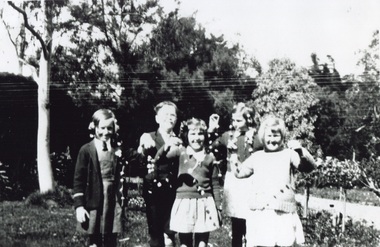
Photograph, Children at Tantallon, 49 York Street in the 1930s, 1930s
... . tantallon house names york street mont albert (mr) john lothian (mr ...This was the home of John Inglis Lothian, father of Thomas Lothian of St Abbs 33 York Street, Mont Albert. John Inglis Lothian was a bookkeeper, who with his wife Lillias Charlotte, née Smith, arrived in Melbourne in July 1888, John having come to represent the publishing firm of Walter Scott. The children had been invited to a garden party where they entertained themselves making daisy chains. Left to right: Emily Broadfoot, David Dory, Betty Hopkinson; at back John Hopkinson; front right Jean Lothian.A black and white photograph of some children holding daisy chains they have made.tantallon, house names, york street, mont albert, (mr) john lothian, (mr) thomas lothian, (miss) emily broadfoot, (mr) david doery, (miss) betty hopkinson, (miss) joan hopkinson, (miss) jean lothian, john inglis lothian, thomas carlyle lothian -
 Surrey Hills Historical Society Collection
Photograph, "Ancyra", 25 Weybridge Street, Surrey Hills
... material. ancyra house names weybridge street surrey hills james ...John Butler Maling, retired farmer, built his home on the corner of his property which extended from Weybridge Street to Whitehorse Road and from James to Ross Street. From 1853 he lived in a simple farmhouse located near the present Ross Street until he had 'Ancyra' built in c.1889 from bricks made from clay dug from a quarry on the property. This was located in the now-park in James Street. John Butler Maling Snr was born in Shepreth, Cambridgeshire. He married Kate Conlan in 1882 and they had 3 children - Silas, Alick and Zillah. He died in 1912 and is buried in Box Hill Cemetery. Often referred to as John Butler Maling Senior as he had a nephew by the same name. He also lived on a similar sized property known as 'The Willows', located to the west. He became the first Mayor of Camberwell. From c1936 til c1960 the property was used as a rest home (Ancyra Rest Home) and then a nursery (Pied Piper Nursery). This is one of relatively few surviving houses that provides links to pre0urban Surrey Hills. It is also built from locally quarried material.A black and white photograph of a house viewed through the front garden.ancyra, house names, weybridge street, surrey hills, james street, bricks, john butler maling senior, miss kate conlan, mrs kate maling, alick maling, silas maling, zillah maling, ancyra rest home, pied piper nursery, box hill cemetery -
 Surrey Hills Historical Society Collection
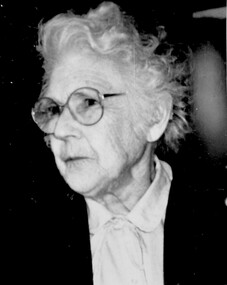
Photograph, Mrs Mona Webster
Born in 1900, Mona was the daughter of Florence Jane McDowall Stuart (1867-1936) and George Hudson Grant (1864-1910) who married in 1899. He was a surveyor and they lived in Albany Crescent, Surrey Hills. Her full name was Jessie Mona Stuart Grant and she had a sister Mollie. In 1924 she married Clarence William Willoughby Webster (1895-1980) - SERN 33286. Clarence was born in Thorpedale where his father was a teacher. He was living in View Street Mont Albert and was a law student when he enlisted on 3 October 1916. After discharge on 10 May 1919, Clarence returned to his studies. He joined a legal firm in the city which became Pearce & Webster (later Pearce Webster Dugdale). Mona and Clarence lived in Surrey Hills and Mont Albert in a number of homes for the remainder of their lives. A black and white portrait of an older lady wearing round wire-rimmed glasses.writers, authors, view street, surrey hills, mont albert, victoria crescent, mrs mona webster, mr clarence webster, jessie mona stuart grant (miss), jessie mona stuart webster (mrs) -
 8th/13th Victorian Mounted Rifles Regimental Collection
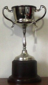
Trophy, McClure Cup
Battery Quartermaster Sergeant Harold Bauerle served with the Albury Battery in the 1920s and 1030s. Shortly following Federation the military unit in Albury was redesignated No 4 New South Wales Battery Australian Field Artillery (AFA). It was under the command of Major John Wilkinson, an Albury solicitor and comprised about 100 citizen soldiers, 4 guns and about 40 horses. Training centred on the Albury Drill Hall located in Victoria Street. A reorganisation in 1912 resulted in the Battery being named No 17 Battery AFA. When war broke out in 1914 the Battery then under the command of Major Joseph Shellshear, and Albury doctor, offered its services as a trained artillery battery to the Australian Imperial Force (AIF). The Battery cooled its heels and continued to train till July 1915 when a second division was raised in the AIF and trained artillery was needed. When the call came 150 officers and men of the 17th Battery went into the AIF, many to the 13th Battery with Major Shellshear in command and others to other AIF batteries of the 4th and 5th Artillery Brigades. The 13th Battery was adopted immediately by the townsfolk of Albury as the Albury Battery. The Battery served in France and Belgium and was involved in all the major battles fought by the Australians perhaps most notably at Noreuil where the Battery found itself surrounded but continued to fight till eventually the enemy was driven back. Following the war members of the Battery nominated this battle as their most significant achievement and consequently a newly developed recreational reserve on the Murray River foreshore was named Noreuil Park. In 1919 the Battery resumed training as part of the Citizen Military Forces or Militia. Changes of title were frequent, first 27th Battery, then 60th Battery and finally 40th Battery AFA. Battery commanders included Captain Leslie Colquhoun, an Albury real estate agent, Captain Roy Collings, Albury town clerk and Captain Clifton Mott a newspaper editor. The Depression of the early 1930s almost brought about the closure of the Albury Battery but it survived through the intervention of the mayor, Alderman Alfred Waugh, who made direct representation to the Minister for Defence. When the Second World War erupted in 1939, the Battery was at full strength and a rich source of officers and trained men for the second AIF. Militia training of the few remaining officers and Albury adopted the 2/23rd Infantry Battalion which had been raised at the Showground. Following WWII, CMF soldiering recommenced in the form of an armoured regiment, the 8th/13th Victorian Mounted Rifles. After nearly a half a century of service in war and peace the Albury Battery has faded and exists now in this collection of objects and images. This trophy is representative of community support for a Citizen Military Forces unit drawn from a regional NSW Town in the period between the World Wars.Silver cup with two handles mounted on Bakelite base being the McClure Cup for most efficient NCO in Albury Battery 1935-36 . inscription on side of cup."McClure Cup / for / Most efficient NCO / 1935-36 / won by / BQMS H.C. Bauerle"bauerle h c bqms, albury battery, mcclure cup -
 8th/13th Victorian Mounted Rifles Regimental Collection
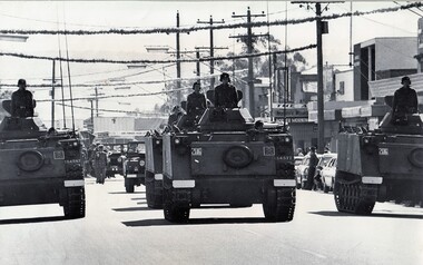
Photograph
8/13 VMR was equipped with M113 Armoured Personnel Carriers in 1970 for reconnaissance training.Collection of photographs showing an armoured regiment of the Citizen Forces in the 1960s as it transitioned from wheeled armoured vehicles to tanks to M113 armoured personal carriers.Black and White photograph of M113 armoured vehicles of 8/13 VMR in street of Wodonga, Victoria leading ANZAC Day march." Anzac Day Wodonga ". Crews are named. -
 Kew Historical Society Inc
Plan, Melbourne & Metropolitan Board of Works : Borough of Kew : Detail Plan No.1291, 1905
The Melbourne and Metropolitan Board of Works (MMBW) plans were produced from the 1890s to the 1950s. They were crucial to the design and development of Melbourne's sewerage and drainage system. The plans, at a scale of 40 feet to 1 inch (1:480), provide a detailed historical record of Melbourne streetscapes and environmental features. Each plan covers one or two street blocks (roughly six streets), showing details of buildings, including garden layouts and ownership boundaries, and features such as laneways, drains, bridges, parks, municipal boundaries and other prominent landmarks as they existed at the time each plan was produced. (Source: State Library of Victoria). This plan forms part of a large group of MMBW plans and maps that was donated to the Society by the Mr Poulter, City Engineer of the City of Kew in 1989. Within this collection, thirty-five hand-coloured plans, backed with linen, are of statewide significance as they include annotations that provide details of construction materials used in buildings in the first decade of the 20th century as well as additional information about land ownership and usage. The copies in the Public Record Office Victoria and the State Library of Victoria are monochrome versions which do not denote building materials so that the maps in this collection are invaluable and unique tools for researchers and heritage consultants. A number of the plans are not held in the collection of the State Library of Victoria so they have the additional attribute of rarity.Original survey plan, issued by the MMBW to a contractor with responsibility for constructing sewers in the area identified on the plan within the Borough of Kew. The plan was at some stage hand-coloured, possibly by the contractor, but more likely by officers working in the Engineering Department of the Borough and later Town, then City of Kew. The hand-coloured sections of buildings on the plan were used to denote masonry or brick constructions (pink), weatherboard constructions (yellow), and public buildings (grey). A detail plan of part of Studley Park bordered by the major streets of Hodgson Street, Stevenson Street and Studley Park Road. Included on the plan are a number of significant Studley Park mansions in existence at the beginning of the 20th century. The unnamed street shown in the middle of the plan is McEvoy Street. The most important house still extant is Campion House, formerly named Dalsraith [Dalswraith] and Glendalough, owned since the 1940s by the Society of Jesus. Campion House can be seen on the corner of Hodgson and Studley Park Road. Its stables at the rear of the block have now been incorporated into a contemporary residence. An interesting feature of the plan is the 1910 annotation by Ed Seitz, professional designing engineer. Is Seitz the contractor who modified the MMBW original?melbourne and metropolitan board of works, detail plans, mmbw 1291, cartography -
 Kew Historical Society Inc
Plan, Melbourne & Metropolitan Board of Works : Borough of Kew : Detail Plan No.1297, 1904
The Melbourne and Metropolitan Board of Works (MMBW) plans were produced from the 1890s to the 1950s. They were crucial to the design and development of Melbourne's sewerage and drainage system. The plans, at a scale of 40 feet to 1 inch (1:480), provide a detailed historical record of Melbourne streetscapes and environmental features. Each plan covers one or two street blocks (roughly six streets), showing details of buildings, including garden layouts and ownership boundaries, and features such as laneways, drains, bridges, parks, municipal boundaries and other prominent landmarks as they existed at the time each plan was produced. (Source: State Library of Victoria)This plan forms part of a large group of MMBW plans and maps that was donated to the Society by the Mr Poulter, City Engineer of the City of Kew in 1989. Within this collection, thirty-five hand-coloured plans, backed with linen, are of statewide significance as they include annotations that provide details of construction materials used in buildings in the first decade of the 20th century as well as additional information about land ownership and usage. The copies in the Public Record Office Victoria and the State Library of Victoria are monochrome versions which do not denote building materials so that the maps in this collection are invaluable and unique tools for researchers and heritage consultants. A number of the plans are not held in the collection of the State Library of Victoria so they have the additional attribute of rarity.Original survey plan, issued by the MMBW to a sewage contractor with responsibility for constructing sewers in the area identified on the plan within the Borough of Kew. The plan was at some stage hand-coloured, possibly by the contractor, but more likely by officers working in the Engineering Department of the Borough and later Town, then City of Kew. The hand-coloured sections of buildings on the plan were used to denote masonry or brick constructions (pink), weatherboard constructions (yellow), and public buildings (grey). This plan of Kew encompasses the area bounded by Barkers Road, High Street and Stevenson Street. Because of the angle created by High Street, a number of houses on the northern side of High Street are shown. The area is dominated by one of the great original landholdings in Kew, described here as the ‘Findon Paddock’. ‘Findon’, the house from which the name of the paddock was taken fronts Stevenson Street and was clearly a rambling structure. The best-known occupant of Findon was Henry ‘Money Miller’ who bought the house in 1871. Miller was a member of Victoria’s first parliament and assisted in the framing of its constitution. Findon was to be subdivided as early as 1912, when the Findon Subdivision was advertised to be sold by auction. In the plan of the subdivision, the original house is not shown, so, presumably it had previously been demolished. Fincham & Son moved the organ, built by Henry Willis, which was installed in the house, first to ‘Whernside’ in Toorak, and later to the Box Hill Methodist Church.melbourne and metropolitan board of works, detail plans, mmbw 1297, cartography, kew (vic.) — municipal collection -
 Kew Historical Society Inc
Plan, Melbourne & Metropolitan Board of Works : Borough of Kew : Detail Plan No.1350, 1910
The Melbourne and Metropolitan Board of Works (MMBW) plans were produced from the 1890s to the 1950s. They were crucial to the design and development of Melbourne's sewerage and drainage system. The plans, at a scale of 40 feet to 1 inch (1:480), provide a detailed historical record of Melbourne streetscapes and environmental features. Each plan covers one or two street blocks (roughly six streets), showing details of buildings, including garden layouts and ownership boundaries, and features such as laneways, drains, bridges, parks, municipal boundaries and other prominent landmarks as they existed at the time each plan was produced. (Source: State Library of Victoria). This plan forms part of a large group of MMBW plans and maps that was donated to the Society by the Mr Poulter, City Engineer of the City of Kew in 1989. Within this collection, thirty-five hand-coloured plans, backed with linen, are of statewide significance as they include annotations that provide details of construction materials used in buildings in the first decade of the 20th century as well as additional information about land ownership and usage. The copies in the Public Record Office Victoria and the State Library of Victoria are monochrome versions which do not denote building materials so that the maps in this collection are invaluable and unique tools for researchers and heritage consultants. A number of the plans are not held in the collection of the State Library of Victoria so they have the additional attribute of rarity.Original survey plan, issued by the MMBW to a contractor with responsibility for constructing sewers in the area identified on the plan within the Borough of Kew. The plan was at some stage hand-coloured, possibly by the contractor, but more likely by officers working in the Engineering Department of the Borough and later Town, then City of Kew. The hand-coloured sections of buildings on the plan were used to denote masonry or brick constructions (pink), weatherboard constructions (yellow), and public buildings (grey). MMBW Plan No. 1350 depicts the western end of Studley Park on the north side of the Studley Park Road. ‘Raheen’, then the home of Sir Henry Wrixon is named, the plan identifying those parts of the house that were built of brick and timber. The two houses between Raheen and the River Yarra are also shown. Other parts of the plan show neighbouring streets: Yarra Street, Studley Park Avenue, Studley Street and Fenwick Street. Each, apart from Fenwick Street was subsequently renamed. At the corner of Fenwick and Stawell Streets, the home of Joseph Butterworth Coombs, later called ‘Hope Mansell’, is represented but unnamed.melbourne and metropolitan board of works, detail plans, mmbw 1350, cartography -
 Kew Historical Society Inc
Plan, Melbourne & Metropolitan Board of Works : Borough of Kew : Detail Plan No.1561, 1905
The Melbourne and Metropolitan Board of Works (MMBW) plans were produced from the 1890s to the 1950s. They were crucial to the design and development of Melbourne's sewerage and drainage system. The plans, at a scale of 40 feet to 1 inch (1:480), provide a detailed historical record of Melbourne streetscapes and environmental features. Each plan covers one or two street blocks (roughly six streets), showing details of buildings, including garden layouts and ownership boundaries, and features such as laneways, drains, bridges, parks, municipal boundaries and other prominent landmarks as they existed at the time each plan was produced. (Source: State Library of Victoria). This plan forms part of a large group of MMBW plans and maps that was donated to the Society by Mr Poulter, City Engineer of the City of Kew in 1989. Within this collection, thirty-five hand-coloured plans, backed with linen, are of statewide significance as they include annotations that provide details of construction materials used in buildings in the first decade of the 20th century as well as additional information about land ownership and usage. The copies in the Public Record Office Victoria and the State Library of Victoria are monochrome versions which do not denote building materials so that the maps in this collection are invaluable and unique tools for researchers and heritage consultants. A number of the plans are not held in the collection of the State Library of Victoria so they have the additional attribute of rarity.Original survey plan, issued by the MMBW to a contractor with responsibility for constructing sewers in the area identified on the plan within the Borough of Kew. The plan was at some stage hand-coloured, possibly by the contractor, but more likely by officers working in the Engineering Department of the Borough and later Town, then City of Kew. The hand-coloured sections of buildings on the plan were used to denote masonry or brick constructions (pink), weatherboard constructions (yellow), and public buildings (grey). MMBW Detail Plan 1561 outlines those residences in the area bordered by Burke Road, Loxton Street, Mount Street and Barkers Road that had been constructed by 1905 when the land was surveyed. At this time, the area nearest Burke Road had been subdivided and developed whereas the lands to the west were as yet undeveloped. The houses represented are not named on the Plan.melbourne and metropolitan board of works, detail plans, mmbw 1561, cartography -
 Kew Historical Society Inc
Plan, Melbourne & Metropolitan Board of Works : Borough of Kew : Detail Plan No.1564, 1905
The Melbourne and Metropolitan Board of Works (MMBW) plans were produced from the 1890s to the 1950s. They were crucial to the design and development of Melbourne's sewerage and drainage system. The plans, at a scale of 40 feet to 1 inch (1:480), provide a detailed historical record of Melbourne streetscapes and environmental features. Each plan covers one or two street blocks (roughly six streets), showing details of buildings, including garden layouts and ownership boundaries, and features such as laneways, drains, bridges, parks, municipal boundaries and other prominent landmarks as they existed at the time each plan was produced. (Source: State Library of Victoria)This plan forms part of a large group of MMBW plans and maps that was donated to the Society by the Mr Poulter, City Engineer of the City of Kew in 1989. Within this collection, thirty-five hand-coloured plans, backed with linen, are of statewide significance as they include annotations that provide details of construction materials used in buildings in the first decade of the 20th century as well as additional information about land ownership and usage. The copies in the Public Record Office Victoria and the State Library of Victoria are monochrome versions which do not denote building materials so that the maps in this collection are invaluable and unique tools for researchers and heritage consultants. A number of the plans are not held in the collection of the State Library of Victoria so they have the additional attribute of rarity.Original survey plan, issued by the MMBW to a contractor with responsibility for constructing sewers in the area identified on the plan within the Borough of Kew. The plan was at some stage hand-coloured, possibly by the contractor, but more likely by officers working in the Engineering Department of the Borough and later Town, then City of Kew. The hand-coloured sections of buildings on the plan were used to denote masonry or brick constructions (pink), weatherboard constructions (yellow), and public buildings (grey). In 1905, when Plan No.1564 was printed, that part of Kew bordered by Brougham Place (now Daniell Place), Mount Street, Sackville Street and Ross Street was already the location of a number of large mansions. Here, subdivisions, at least at this stage, produced larger blocks than in Central Kew. Many of the houses on this plan are named: ‘Faybrook’, ‘Northumbria’, ‘Parkholm[e]’, ‘Dunboe’, ‘Katoomba’ and ‘Eschol’ fronting Sackville Street. Eschol was once the home of the manufacturer Robert Harrison, whose cordial factory in Spring and Argyle Streets Fitzroy are noted on the Victorian Heritage Register. ‘The Hawthorns’ on the corner of Brougham Place and Mount Street was the home of the medical practitioner Frank William Fay, who won the military cross and other honours for conspicuous gallantry and devotion to duty in World War 1.melbourne and metropolitan board of works, detail plans, mmbw 1564, cartography