Showing 3902 items matching "bricker"
-
 Eltham District Historical Society Inc
Photograph - Digital Photograph, Alan King, Downing-Le Gallienne house, Yarra Braes Road, Eltham, 30 January 2008
The property is a classic example of what made Eltham famous from the late 1940s to the 1960s. Covered under Heritage Overlay, Nillumbik Planning Scheme. Published: Nillumbik Now and Then / Marguerite Marshall 2008; photographs Alan King with Marguerite Marshall.; p149 The first view of the large double-storey house at Yarra Braes Road, Eltham South, is of a jutting roofline over a balcony, reminiscent of a large sailing vessel or galleon – very appropriate, considering the name of one of the first owners, Le Gallienne. The Downing-Le Gallienne property is a classic example of what made Eltham famous from the late 1940s to the 1960s and attracted so many artists and intellectuals to the area. Set in a largely indigenous bush-style garden, the mud-brick and timber house was built by Alistair Knox. It was built for economist Richard Downing, to become a founder of the welfare state in Australia and Chairman of the Australian Broadcasting Commission, and musician and composer Dorian Le Gallienne. Le Gallienne was a pioneering composer of modern music in Victoria before 1945, whose works included the Symphony in E.1 He wrote several pieces of film music for Eltham Films, including The Prize, working with its writer and artistic director Tim Burstall. Le Gallienne was also a music critic for The Argus and later for The Age. In 1967 the music critic Roger Covell argued that Le Gallienne’s Symphony, was ‘still the most accomplished and purposive . . . written by an Australian’. According to Alan Marshall the main inspiration behind the building that evolved from 1948 to 1964 was Le Gallienne. ‘He was able to see value in the simplest things and many who worked there had their eyes opened for the first time to the Eltham environment, to the bush and the trees and the fauna which lived there.’ The garden included no formality, no lawns, nor exotic plants. ‘Natural informal growth came right up to their doors and so did the indigenous birdlife.’ This informal style – consisting of mass and void – was to be developed and popularised by landscaper Gordon Ford from the 1950s. The large mud-brick and timber house, which was built in four stages and has three separate but linked sections, began as a small weekend retreat for the couple. In 1948, Downing and Le Gallienne (Dick and Dor to their friends), asked Knox to build the 36 x18 foot (11mx5.4m) building with a pitched slate roof. It was built on a concrete slab and included a fireplace, which is still in use. The second wing was built in 1954 after Downing had returned from working at the International Labour Office and the couple decided to live there full-time. The third section was built after the death of Le Gallienne in 1963, aged 48. He is buried in the Eltham Cemetery. When Downing married widow, Jean Norman (nee McGregor) and had to accommodate a large family, including her six children and one of their own, the last stage was built by 1964. At that time the house was considered one of the largest mud-brick houses in Victoria. It consists of five living areas, including a small ballroom. Several artists helped Knox build the Downing-Le Gallienne house, which was one of his first of mud-brick. They included painter Clifton Pugh, artist John Howley and actor Wynn Roberts. Ellis Stones had landscaped the first wing and Gordon Ford set the boulder steps and made a pool as part of the landscaping he completed. Inside, the mud-bricks are largely whitewashed with pine-lined ceilings and Oregon beams. A winding timber staircase in the front extends behind a glass window from the ground floor to the top. The property, of a little more than 0.5 ha, is bordered by Parks Victoria land, which extends to the Yarra River.This collection of almost 130 photos about places and people within the Shire of Nillumbik, an urban and rural municipality in Melbourne's north, contributes to an understanding of the history of the Shire. Published in 2008 immediately prior to the Black Saturday bushfires of February 7, 2009, it documents sites that were impacted, and in some cases destroyed by the fires. It includes photographs taken especially for the publication, creating a unique time capsule representing the Shire in the early 21st century. It remains the most recent comprehenesive publication devoted to the Shire's history connecting local residents to the past. nillumbik now and then (marshall-king) collection, dorian le gallienne, downing-le gallienne house, eltham, mudbrick construction, mudbrick houses, richard downing, yarra braes road -
 The Beechworth Burke Museum
Photograph
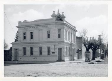
The old Bank of New South Wales building is located on the corner of Camp and Ford streets in Beechworth, Victoria. It was constructed between 1856 and 1857 from local honey coloured granite. It was designed by architects Robertson & Hale and is a two-storey rendered brick building and the original coat of arms is still visible. The coat of arms is distinctive and consists of a kangaroo, emu, lion, and rising sun. The rear of the building was surrounded by high granite walls for security as it was the original home for the local gold office. Beechworth Honey currently offers tourist accommodation in the Hive Apartment located in the former Bank of New South Wales Managers residence.The Bank of New South Wales building in Beechworth is significant for its location in one of Australia's most prominent goldfield towns. Of particular interest is the use of distinctive local Beechworth honey coloured granite in its construction. The building’s architecture is a simple, conservative classical style known as Renaissance Revival. It is one of the few known surviving works of the architects Robertson and Hale. The decorative composition above the main entrance and the counter in the banking chamber are of special interest.Black and white rectangular photograph printed on cardAHold bank of new south wales, bank of new south wales building, beechworth bank of new south wales, bank of nsw, beechworth 1850s, robertson and hale, architects robertson and hale, rendered brick, coat of arms, granite walls, local honey coloured granite, gold office, 1856, 1857, beechworth, beechworth honey, hive apartment, manager's residence, renaissance revival -
 Mission to Seafarers Victoria
Letter - Correspondence, Stanley Quinn et al, 1949
Letter 0817a; the writer refers to Allan's 21st birthday and his recent letter from Rio. He also writes of prices rising in Australia, the coal strike, and that 'Sydney especially is badly hit'. He also recommends Allan see a film called 'The Secret Land', a record of an American Naval Expedition to the South Pole, if he gets the opportunity. Letter is signed 'Your loving Dad, Stanley Quinn'. Writer of 0817d also refers to Allan's 21st birthday and the coal strike which has affected manufacturing and the availability of materials, especially bricks as all the brickworks are closed down. The letter is signed 'Your Pal Norm'.Quinn CollectionThree-page letter written to Allan (0817.a1-3) from his father, Stanley Quinn, on three sheets of lined cream-coloured paper, headed Liddesdale Avenue, Frankston and dated 25.07.49. The envelope (0817.b) is buff-coloured. Also found in this envelope is a single-sided, two-page letter written on thin off-white lined paper (0817.c1-2) to Allan from his friend Norm headed 1 Selwyn Street, Artarmon, dated 27.07.49. Enclosed with 0817.c are two small black and white photographs (0817.d1-2). 0817.d1 shows a small boy with a model airplane and 0817.d2 the model airplane from a different angle.Letter 0817a is written on the reverse side of three pages of the Melbourne Stevedoring Company's Cargo Tally sheets. The envelope is pre-stamped with an embossed profile of King George V and a crown in white on a red, oval background. Postage is two and a half pence. Envelope is addressed to Allan C/- Swedish Seaman's Union, 156 Montague Street, Brooklyn, New York, USA. The postmark is torn. There is a blue air-mail sticker on the upper left-hand corner. 0817d; On the left wing of the model airplane is printed MAA, on the right wing - 17. There are pencilled marks on the back of each photograph. letters-from-abroad, quinn, 1949, stanley quinn, coal strike, australia -
 Victoria Police Museum
Police Stations (Anglesea)
Anglesea is a town on the Great Ocean Road in the Surf Coast Shire local government area. It is 110km from Melbourne. Before 1967 policing in Anglesea was on a seasonal basis with a 'shop front' police station and caravan in the main street. Anglesea Police Station (Barwon District) was opened on 7 February 1967 on the corner of Wray Street and The Great Ocean Road. It was a residential police station, brick veneer with an iron roof with 3 rooms, a bathroom, laundry and a garage. When the station opened it was staffed by one Senior Constable and two First Constables. List of staff from 1967-2002 is available from Victoria Police Museum10 photographs comprising: 8 black and white photos, 2 colour photospolice stations; anglesea police station -
 City of Moorabbin Historical Society (Operating the Box Cottage Museum)
Photographs, x 4 Black & White, Whitmuir Hall / Killearnan / Bentleigh Club 1930, c1930
Whitmuir Hall was built 1850 using bricks hand -made from the clay of nearby Elster Creek. Early history of the 156 acre estate bounded by McKinnon, Centre, Thomas and Wheatley Roads is obscure. The gardens were laid out prior to 1850. Robert Gray Ford purchased 20 acres with mansion in 1872 for £ 1750 and it was valued at £ 25,000 in 1888 but sold after the Bank Crash 1890's for £ 5,000 in 1892. There were many owners over the years including Thomas Bent and in 1870 it was called 'Killearnan'. It is now is known as 'the Bentleigh Club and many original features have been restored and preserved . Whitmuir Hall, was a stately mansion built 1850 typical of the grandiose plans of successful early settlers. Stained glass Windows, furniture, imported from France and Italy have been preserved by the Bentleigh Club.4 of 13 Black & White photographs of Whitmuir Hall now Benleigh Club, Yawla St Bentleigh c 1930whitmuir hall, bentleigh club, killearnan, mansions, gold rush victoria, smith j l; smith mary ann, stanley helen, smith vic, smith harry redvers, chaff cutter, horse drawn carts, toll gates brighton, motor cars 1900, steam engines, early settlers, bentleigh, parish of moorabbin, city of moorabbin, county of bourke, moorabbin roads board, shire of moorabbin, henry dendy's special survey 1841, were j.b.; bent thomas, o'shannassy john, king richard, charman s, highett william, ormond francis, maynard -
 Kew Historical Society Inc
Photograph - Laying the foundation stone of the Kew Baptist Church, 1922
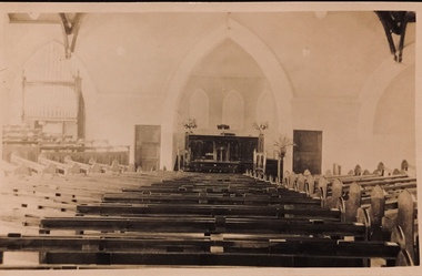
The Kew Baptist Church was originally located on the corner of Cotham Road and St John’s Parade. In 1922, work commenced on a new, larger church in Highbury Grove. The foundation stone of the new building was laid by Cr Ratten of the City of Kew on Saturday 14 October 1922, with the First Kew Scouts forming a guard of honor. A collection taken up at the laying of the foundation stone raised £454. The site and building cost approximately £6,000. The architects for this new red brick ‘semi-Gothic’ church were Messrs Gawler & Drummond. The interior of the church accommodated 500 parishioners. The seating sloped towards the pulpit with no columns obstructing the view of the worshippers. An item from an outstanding and diverse photographic collection, assembled by members of the Christian and Washfold families of Kew. This remarkable photograph is a silver albumen photograph of what was by then a significant religious group in Kew. Photographic positive on mounting board of laying of the foundation stone of the new Kew Baptist Church in Highbury Grove, Kew, The foundation stone of the church was laid on 14 October 1922 by Councillor F.R. Patten J.P. The church was opened on 9 June 1923."Building Kew Baptist"washfold family, kew baptist church -- highbury grove -- kew (vic.), churches -- kew (vic.), christian-washfold collection -
 Kew Historical Society Inc
Postcard - Interior, Kew Baptist Church, 1920s
The Kew Baptist Church was originally located on the corner of Cotham Road and St John’s Parade. In 1922, work commenced on a new, larger church in Highbury Grove. The foundation stone of the new building was laid by Cr Ratten of the City of Kew on Saturday 14 October 1922, with the First Kew Scouts forming a guard of honor. A collection taken up at the laying of the foundation stone raised £454. The site and building cost approximately £6,000. The architects for this new red brick ‘semi-Gothic’ church were Messrs Gawler & Drummond. The interior of the church accommodated 500 parishioners. The seating sloped towards the pulpit with no columns obstructing the view of the worshippers. Faded sepia 'real photo' Kodak postcard of the interior and altar of Kew Baptist Church "Interior of Kew Baptist Church"kew baptist church -- highbury grove, churches -- kew (vic.), baptist churches, christian-washfold collection -
 Kew Historical Society Inc
Postcard - Kew Baptist Church, 1920s
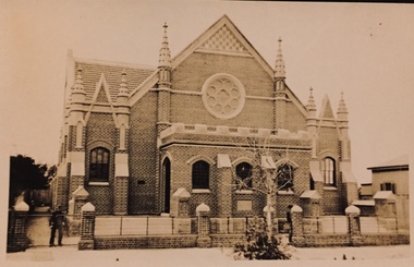
The Kew Baptist Church was originally located on the corner of Cotham Road and St John’s Parade. In 1922, work commenced on a new, larger church in Highbury Grove. The foundation stone of the new building was laid by Cr Ratten of the City of Kew on Saturday 14 October 1922, with the First Kew Scouts forming a guard of honor. A collection taken up at the laying of the foundation stone raised £454. The site and building cost approximately £6,000. The architects for this new red brick ‘semi-Gothic’ church were Messrs Gawler & Drummond. The interior of the church accommodated 500 parishioners. The seating sloped towards the pulpit with no columns obstructing the view of the worshippers. An item from an outstanding and diverse image collection, assembled by members of the Christian and Washfold families of Kew. This early photo of the Kew Baptist Church shows its original fence, built by Henry Clifford Washfold, the father of the donor.Faded sepia real photo Kodak postcard of the exterior of Kew Baptist Church in Highbury Grove. Image shows original fence and paintwork of windows."Dad built the fence"kew baptist church -- highbury grove, churches -- kew (vic.), baptist churches, christian-washfold collection -
 Kew Historical Society Inc
Postcard - Kew Baptist Church, 1920s
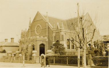
The Kew Baptist Church was originally located on the corner of Cotham Road and St John’s Parade. In 1922, work commenced on a new, larger church in Highbury Grove. The foundation stone of the new building was laid by Cr Ratten of the City of Kew on Saturday 14 October 1922, with the First Kew Scouts forming a guard of honor. A collection taken up at the laying of the foundation stone raised £454. The site and building cost approximately £6,000. The architects for this new red brick ‘semi-Gothic’ church were Messrs Gawler & Drummond. The interior of the church accommodated 500 parishioners. The seating sloped towards the pulpit with no columns obstructing the view of the worshippers. An early real photo Kodak postcard of the Kew Baptist Church showing its original fenceFaded sepia postcard taken at an oblique angle of exterior of Kew Baptist Church in Highbury Grove. Image shows original fence and paintwork of windows. Photo shows parts of adjacent buildings. Two women walking past on footpath. "Kew Baptist Church"kew baptist church -- highbury grove, churches -- kew (vic.), baptist churches, christian-washfold collection -
 Kew Historical Society Inc
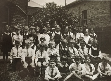
Photograph - Clarence Kindergarten and Sub-Primary, 180 Cotham Road, 1930-1935
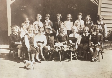
180 Cotham Road, formerly 178 and later 210 Cotham Road, described as a brick residence of six rooms, was constructed in c.1890, for Alexander Hall, a dentist. From 1903, Miss Florrie Wymond operated a girls school at the property, and a timber schoolroom building was constructed at the rear of the property. During the 1930s, the school was known as the Clarence Primary School, and operated by Misses F L and M Wymond. While the listing of the property as a primary school had ceased by 1947, the Wymond family owned the property until the mid 1960s. (Source: Lovell Chen 2007, Review of B-graded buildings in Kew, Camberwell and Hawthorn).One of three photographs taken between 1930 and 1935 of students of 'Clarence' Kindergarten and Sub-Primary, located at 180 Cotham Road. The photos were accompanied by detailed notes identifying the names of students (where remembered).schools -- kew (vic.), clarence school, clarence house, 180 cotham road -- kew (vic.) -
 Kew Historical Society Inc
Photograph - Clarence Kindergarten and Sub-Primary, 180 Cotham Road, 1930-1935
180 Cotham Road, formerly 178 and later 210 Cotham Road, described as a brick residence of six rooms, was constructed in c.1890, for Alexander Hall, a dentist. From 1903, Miss Florrie Wymond operated a girls school at the property, and a timber schoolroom building was constructed at the rear of the property. During the 1930s, the school was known as the Clarence Primary School, and operated by Misses F L and M Wymond. While the listing of the property as a primary school had ceased by 1947, the Wymond family owned the property until the mid 1960s. (Source: Lovell Chen 2007, Review of B-graded buildings in Kew, Camberwell and Hawthorn).One of three photographs taken between 1930 and 1935 of students of 'Clarence' Kindergarten and Sub-Primary, located at 180 Cotham Road. The photos were accompanied by detailed notes identifying the names of students (where remembered).schools -- kew (vic.), clarence school, clarence house, 180 cotham road -- kew (vic.) -
 Surrey Hills Historical Society Collection
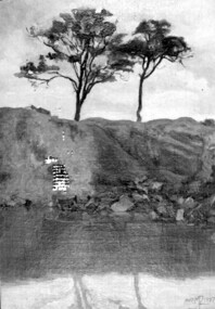
Painting, Muriel Pornitz (Pornett), "The old quarry" by Muriel Pornitz, 1927
The waterbody was the site of a quarry that existed between Grovedale Road and James Street, Surrey Hills on land owned by J B Maling (senior). Clay from it was used to make bricks for local houses. The quarry became a hazard and after several drownings was filled in. The Grovedale Park now occupies the site. Muriel Hedwig Lucy Pornitz, also known as Muriel Pornett, lived locally. She was born in Melbourne in 1894 and studied at the South Australian School of Arts & Crafts in 1911 under James Ashton and Fred Britton, and at the Australian School of Etching in Sydney. She was also an illustrator and cartoonist. She died in 1982.A small oil painting on canvas board in a dark wood frame of a water body with a clay bank behind and 2 trees above the bank. Lower front right hand corner: "AUST. M P 1927" On the rear upper edge, in ink on badly degraded brown paper backing: " "The Old Quarry" Surrey Hills, Melb." / [Second line of writing is illegible.] A label is stuck to the middle section of the paper backing. It indicates that the painting was framed by Toska Art Studio (N. Cl Colliver, Proprietor) of wyndham Street, Shepparton. Lower rear edge, in ink on badly degraded brown paper backing: "by / Muriel ...... / "Darnok", / 22 Grovedale Rd / Surrey Hills, Melb" painting, grovedale road quarry, quarry, grovedale road park, john butler maling (snr), surrey hills, muriel pornitz, muriel pornett -
 Eltham District Historical Society Inc
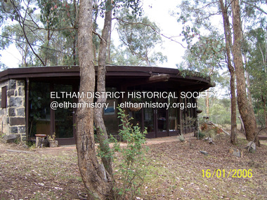
Photograph - Digital Photograph, Marguerite Marshall, Former office of Alistair Knox, King Street, Eltham, 16 January 2006
Situated in King Street, Eltham, Alistair Knox built his home and office in 1962-1963 with mud-bricks made from the local soil and recycled materials blending the house with bush around it. Knox popularised the Eltham earth building movement, begun by Montsalvat founder, Justus Jorgensen. Alistair Knox (1912-1986) was also an Eltham Shire Councillor 1971-1975 and Shire President in 1975. He established the inaugural Eltham Community Festival in 1975. Covered under Heritage Overlay, Nillumbik Planning Scheme. Published: Nillumbik Now and Then / Marguerite Marshall 2008; photographs Alan King with Marguerite Marshall.; p145This collection of almost 130 photos about places and people within the Shire of Nillumbik, an urban and rural municipality in Melbourne's north, contributes to an understanding of the history of the Shire. Published in 2008 immediately prior to the Black Saturday bushfires of February 7, 2009, it documents sites that were impacted, and in some cases destroyed by the fires. It includes photographs taken especially for the publication, creating a unique time capsule representing the Shire in the early 21st century. It remains the most recent comprehenesive publication devoted to the Shire's history connecting local residents to the past. nillumbik now and then (marshall-king) collection, alistair and margot knox house, alistair knox design, mudbrick construction, eltham, king street -
 Eltham District Historical Society Inc
Photograph, K.D. Ingram's Shell Garage, Research, Vic, c.1930
The inscription on the back of the photo incorrectly states the garage is at Anglesea. It is in fact at Research, Victoria. Kenneth Douglas Ingram moved from Research to his holiday home at 9 Minifie Avenue, Anglesea between 1943-1949. He established a new garage at Anglesea which was a concrete block design building, not a tin shed as this at Research. This garage was located between the family home and the public hall at Research on the original line of Main Road. The public hall site is now the site of the Eltham Little Theatre. The family home, a red brick building still stands today (2023) at 1591 Main Road, ResearchOn reverse "Garage, Anglesea"k.d. ingram shell garage, kenneth douglas ingram, main road, pam thoonen (nee ingram) collection, research (vic.), research garage -
 Eltham District Historical Society Inc
Newsletter, Newsletter, No. 258 June 2021
Contents: • Eltham Court House by Jim Connor • Fifty Years Ago In Eltham South; A historic tree planting by Michael Aitken • Heritage Excursion –Saturday 10th July • A Mud Brick Meander by Jim Connor • Eltham Watering Place Reserve (Shire of Eltham Heritage Study appendix 1-2) • Eltham Wurundjeri History by Jan Aitken • A Well Deserved Award of Merit by Jim Connor • Annual General Meeting - 2.00pm, Saturday 12th June 2021 • Eltham Cemetery Stories by Richard Pinn o Pauline Therese Toner o Bertram Barney Wainer • Contacts for the Eltham District Historical SocietyThe Shire of Eltham Historical Society was formed in October 1967. The first newsletter of the Society was issued May 1978 and has been published continuously ever since on a bi-monthly basis. With the cessation of the Shire of Eltham in late 1994, the Society's name was revised to Eltham District Historical Society and this name first appeared with issue No. 103, July 1995. The collection of the Society's newsletters provides a valuable resource on the history of the Society's activities, office bearers and committee members, guest speakers and subjects of historical interest pertinent to the former Shire of Eltham and the Eltham District.A4 newsletter distributed to members (Digital and A4 photocopy)newsletter, eltham district historical society, covid-19, coronavirus pandemic -
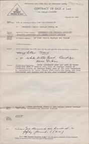
 Bendigo Historical Society Inc.
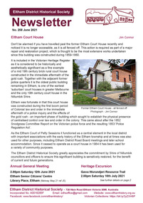
Document - H.A. & S.R. WILKINSON COLLECTION: CONTRACT OF SALE
Contract of sale of land dated 22nd November, 1956 between Mr. W.N. Nicholls (seller) and Mr. G.A. & Mrs. M.L. Quirk (buyers) for piece of land being lot 17 of plan of subdivision No. 33303 lodged in the office of titles being part of Crown allotment 16 section 7A, Kangaroo Flat and situate corner Camp and carpenter Streets, Kangaroo Flat, together with brick veneer dwelling and all sundry, also all electric light fittings and shades. Price 4,500 pounds.organization, business, h.a. & s.r wilkinson real estate -
 Bendigo Historical Society Inc.
Photograph - T C WATTS & SON COLLECTION: HARGREAVES STREET, BENDIGO, 1930
William James Trembath (13/4/1877-27/3/1930) was a draper who lived with his wife Mary Florence (nee Ellis) ( 1877 -29/7/1932) at 521 Hargreaves Street. They had married in 1901. Also living with them in 1924 was their daughter, Mavis Eileen who was a typist.Black and white photograph mounted on rectangular brown board. House, weatherboard, corrugated iron gabled roof, cross and finial to exterior of gable end, brick chimney, decorative, twin pots, battens to gable ends, rectangular louvred vent, telephone connections, leadlight porthole window, awned 4 light window, frieze to awning and verandah, masonary steps, cement path, lawns. Palm tree front left hand side of house. On back of photo ' £1200, Mrs. Trembath, Hargreaves Street'Frank A. Jeffree Photo Bendigobendigo, business, t c watts and son, s -
 Bendigo Historical Society Inc.
Document - H. A. & S. R. WILKINSON COLLECTION: CONTRACT OF SALE
Contract of sale of land dated 20th January, 1956 between Sandhurst & Northern District Trustees Executors& Agency (vendor) and Mrs. M. E. Taylor (purchaser). Property: land being Crown allotment 9 and part of Crown allotment 9A section 55C Parish of Sandhurst city of Bendigo, land described in certificate of title volume 4258 folio 516 land coloured red on the plan endorsed hereon, together with brick dwelling known as 199 Bridge Street, Bendigo. Price: 2,650 Pounds.organization, business, h.a. & s.r wilkinson real estate -
 Bendigo Historical Society Inc.
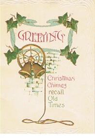
Document - MALONE COLLECTION: GREETING CARD
Malone Collection. Greeting card. Small white card with green holly at each corner of a blue uneven frame with Greeting in red print inside it. Below is a wheel with two bells in the centre and a rope hanging from the wheel (in gold) in front of a blue brick wall. Christmas Chimes (in red) recall (in gold) Old Times (in green). Around the edge is a wavy embossed border. The card and it's insert is held together with a creamy, twisted piece of cord. Given to Miss Malone from one of her Students.person, individual, greeting card, malone collection, greeting card -
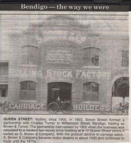 Bendigo Historical Society Inc.
Newspaper - JENNY FOLEY COLLECTION: QUEEN STREET
Bendigo Advertiser "The way we were" from 1999. Queen Street: factory, circa 1900. In 1893, Simon Brown formed a partnership with Charles Turner in Williamson Street, Bendigo, trading as Brown&Turner. The partnership had ceased by 1900 when the business was relocated to a modern two-storey brick building at 8-12 Queen Street where it traded as S. Brown & Company. With the gradual decline in carriage sales S. Brown & Companybecame motor dealers in about 1930 and continued to trade until the 1970s.newspaper, bendigo advertiser, the way we were -
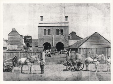 Bendigo Historical Society Inc.
Photograph - WES HARRY COLLECTION: SAYER'S NORFOLK BREWERY, 1860's
Photograph of a two storied brick building, Norfolk Brewery, Bridge Street, Bendigo. Later taken over by William Bruce and became the BB Brewery. There are two large arched doorways in which there are several workmen and a number of barrels. There are several smaller wooden buildings flanking the main one. There is a dovecote centre left of the photo. Outside the log fence there is a workman holding a horse and cart on which there are several Barrels. On the side of the cart is the painted sign ' Sayer Bros ' and on the left of the gateway can be seen Batchelders photographic cart.Batchelderbuildings, commercial, sayer bros. brewery, sayer bros. brewery, bridge street, dovecot -
 Bendigo Historical Society Inc.
Photograph - J L FAUL, BILL LANSELL & RISING SUN HOTEL - PHOTO, 1905
Photograph. J L Faul, Bill Lansell & Rising Sun Hotel - photo. Cardboard mounted photograph of 3 men in a 2 seater motor car with the Rising Sun Hotel in the background. Two men in photo - J L Faul & Bill Lansell. Photo dated 1905. Rising Sun Hotel is a stone and brick structure with a tin roof. Picket fence and post and rail fence visible. On the back: J L Faul, driver; 1905, somewhere in Victoria (in pen) 8/1905 in pencil.photograph, j l faul, bill lansell, rising sun hotel -
 Southern Sherbrooke Historical Society Inc.
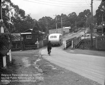
Photograph, Belgrave Railway Bridge, 1947
Belgrave railway bridge looking towards Bayview Road from Terrys Ave, 1947. It shows a bus crossing the bridge onto (now) Belgrave-Gembrook Road, followed by a male cyclist wearing a dark overcoat and bowler hat. A man wearing a homburg hat is crossing the footbridge beside the main bridge towards the main street. There is a pale van parked (or driving past) a dairy on the corner of Bayview Rd and Belgrave-Gembrook Road. A brick toilet block is shown with a sign saying 'MEN' on a nearby lamp post. -
 Southern Sherbrooke Historical Society Inc.
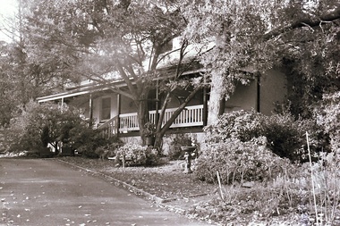
Photograph, Visit to Mt Heatherly, early 2000s
Photos of Mt Heatherly, an historical building in Belgrave, opposite Belgrave Lake Park. Address is Park Drive, on the corner of Waratah Ave. The house is now owned by Mrs Elizabeth Schneider, and was first constructed around 1881 by the first owner of the selection, Ormond Smith. It was made of hand-made bricks made on site, and a foundation of rock and stone. The original house may have had a corrugated iron roof. The original house forms part of the modern house. Photos taken in early 2000s by Susan Heywood-Downard. -
 Kew Historical Society Inc
Photograph - Double-fronted Edwardian Villa, c.1918
The Kew Historical Society's map collection includes a substantial number of real estate subdivision plans, mainly of Kew but also of surrounding suburbs in Melbourne. Most of the subdivision plans date from the 1920s and 1930s when the districts old homes and local farmland were being split up to accommodate residential growth in the postwar period. These early plans were assembled by a local firm, Jas R Mather & McMillan, which had an office in Cotham Road. Many of the plans, and sometimes photos, were annotated by the agents.Subdivision plans are historically important documents used as evidence for the growth of suburbs in Australia. They frequently provide information about when the land was sold as well as evidence relating to surveyors and real estate and financial agents. The numerous subdivision plans in the Kew Historical Society's collection represent working documents, ranging from the initial sketches made in planning a subdivision to printed plans on which auctioneers or agents listed the prices for which individual lots were sold. In a number of cases, the reverse of a subdivision plan in the collection includes a photograph of a house that was also for sale by the agent. These photographs provide significant heritage information relating house design and decoration, fencing and household gardens.The photograph may also be aesthetically significant depending on the importance of the photographic atelier.On the reverse of a subdivision plan of the Palmyra Estate (Kew) is a photograph of a double-fronted Edwardian villa. The weatherboard and stucco house with high brick chimneys provides a clear indication of the style of curtains and gardens in houses of the period. Holland blinds with lace inserts are used in the left front window. They are combined with long lace curtains. The garden, with its curved pathway is bordered with garden beds that include marguerite daisies and roses. Reflecting a new interest in the Australian landscape, tree ferns and ground ferns are planted closer to the house.houses - kew, architecture - edwardian, real estate photographs -
Kew Historical Society Inc
Archive (Sub-series) - Subject File, 'Fairview', 34 Wrixon Street (Kew), 1979
Various partiesReference, Research, InformationSecondary Values (KHS Imposed Order)Subject file containing information about Fairview (built 1924 for F.F. Robinson, proprietor of Yarra Falls Mills). The house replaced an earlier single-storey brick house, also called Fairview. A comprehensive report prepared by Alan Willingham in 2006 found that there was no evidence that the architect Desbrowe-Annear incorporated parts of the original building in the new construction. The work by Willingham is a ‘Cultural and Architectural History and Assessment of the Cultural Heritage Significance’ of the building, prepared for Carey Grammar School. The Willingham report was donated by Sr Ruth Anderson.kew (vic) - history, fairview - 34 wrixon street - kew (vic), cluny house - 34 wrixon street - kew (vic), f.f. robinson, alan willingham, harold desbrowe-annearkew (vic) - history, fairview - 34 wrixon street - kew (vic), cluny house - 34 wrixon street - kew (vic), f.f. robinson, alan willingham, harold desbrowe-annear -
 Warrnambool and District Historical Society Inc.
Functional object - Cloth Chart, A.E. Putnam Co. Iowa, U.S.A, c. 1896
This item was used to measure accurately the length of cloth on a bolt of material without unwinding it. It also measured lace, all types of textiles and spools of ribbon. It is surmised it would have been used in general stores or department stores in the late 19th and early 20th centuries. This item was discovered in the late 1980s behind an old safe at Swintons Stores in Timor Street in Warrnambool. The item appears to have been used extensively and would have been very useful during a stocktake. It may have been used in the Swinton Stores which were first established in Timor Street in 1865 with one section of the stores selling furnishings, furniture, clothing and clothing materials. The item was manufactured by A.E. Putnam of Iowa, U.S.A. There was a patent registered in 1896 and a later 'improved' model with a patent date of 1907. This item is of considerable interest because of its rarity and survival, its connection to Warrnambool General Stores in the past and its value as a research tool in local social and economic history. The possible connection to Swintons Stores is important as this business operated from 1865 to 2024 and was one of the longest-surviving family businesses in Australia. This is a rectangular-shaped wooden pole with one slightly flattened side and numbers marked on each side in patterns resembling brick walls. At the top of the pole are two wooden pieces attached to the pole by metal clips held by screws. The two wooden pieces are attached at a slight angle to the pole. The lower wooden piece is movable along the pole and has incised numbers. The wooden pieces are rectangular in shape with a large curved piece cut out to form the shape of a pennant. The maker's name is incised into the metal on the top attached wooden piece. Putnam's Cloth Chart Copyrighted 1896 Patent Pend'ggeneral stores in warrnambool, swintons stores in warrnambool, vintage measuring instrument for cloth -
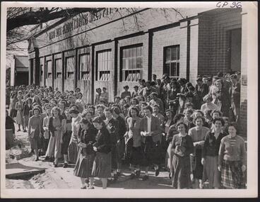 Bendigo Historical Society Inc.
Photograph - HANRO COLLECTION: PHOTOGRAPH OF HANRO STAFF
See Item 11000.189Photograph of Hanro Staff: Black and white photo taken outside the Hanro factory in Hargreaves Street Bendigo. A brick building with eight windows and two entrances. At the top it reads *Hanro Aust Bendigo Knitting Mills. Right top hand written in blue ink is *GP 96*. On the back hand written in blue ink is *Staff of Hanro Knitting Mills Bendigo. GP.96. The Royal Historical Society of Victoria, Bendigo Branch has its stamp in the centre in blue ink. Box 116Aphotograph, person, hanro -
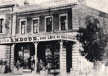 Linton and District Historical Society Inc
Photograph, Criterion House, Sussex Street, Linton
Date of the photograph is not known. Criterion House was built by Samuel Steele in 1862/1863. Samuel Steele left Linton in the late 1860s, but it is not known if B. N. Dodd was the next owner of the building. B. N. Dodd was mentioned in advertising as a Linton draper in 1878. He sold the shop and moved to Ballarat in 1887. The upper floor of the building was used as a hospital from around the end of WWI to the early 1920s. The building was demolished around 1938/39, in connection with the rebuilding of new offices for the Shire of Grenville.Digital copy of original photograph, which shows a two-storey brick building with a verandah. There are four windows across the second storey. A sign across the front of the verandah reads "...TFITTER. B. N. DODD. DRAPER. MILLINERY". A man is leaning on a verandah post at the front of the shop near the entrance, and a woman is standing on the left of the picture, behind a box or counter. Several children are sitting on boxes or bales outside the shop. Ground floor windows have signs reading "DRAPER", "OUTFITTER", "MILLINERY". (A fourth sign is illegible.)criterion house, samuel steele, b.n. (benjamin nunnington) dodd, drapers, shops, sussex street linton