Showing 913 items matching " railway construction"
-
 Otway Districts Historical Society
Photograph, Knox Collection, Surveying construction near Barongarook, 1900, 1900
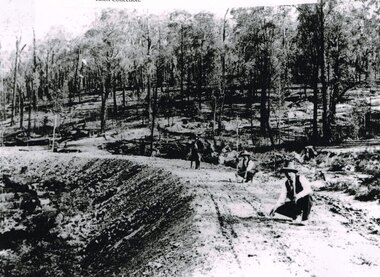
... , to cost $138,000. Construction of the Colac-Beech Forest railway... Standing Committee on Railways, to cost $138,000. Construction ...In 1898 a recommendation for a railway of 2 ft 6 in gauge was handed down by the Parliamentary Standing Committee on Railways, to cost $138,000. Construction of the Colac-Beech Forest railway line began in 1900. About 100 men were employed in laying and ballasting the track while others formed the earthworks and the building of culverts and bridges. The earthworks of gravel ballast 150 mm deep were formed by horse and scoop or by shovel. Once the bed had been laid surveyors went along to check the layout, particularly all check rail curves and all 100 metre curves which the surveyors in the picture are doing.B/W. Three men surveying the construction of a curved bed on which track will be laid, near Barongarook, Victoria.colac; beech forest; barongarook; railways; -
 Ballarat Heritage Services
Photograph - Photograph - Colour, Clare Gervasoni, Nimon's Bridge, 1999, 04/10/1999
... methodology that stimulated the explosion of railway construction... methodology that stimulated the explosion of railway construction ...Nimons Bridge was built in 1890, as part of the then Ballarat-Linton railway. The bridge is 17 spans with tall timber piers of four driven piles each, with triple sets of diagonal cross-bracing and walers and a single row of longitudinal horizontal bracing between piers. The spans are of a uniform twenty feet (6.1 metres), originally supported by four 21-inch x 9-inch (535 mm x 230 mm) Kauri timber beams per span, following the standard V.R. design of the period. When the superstructure was rebuilt after the 1953 fire, the timber beams were replaced with two 24-inch (610mm) deep rolled-steel-joists on each span. These are marked 'Lancashire Steel Co., Scotland' and are believed to have been second-hand. The deck of transverse-timber planks is 103.6 metres in length. Overall the bridge has an impressive appearance with its exceptionally tall triple-cross-braced piers creating a 'three-tiered' effect, with the deck 19.2 metres above the Woady Yaloak River. The Ballarat-Skipton line closed in 1985. Nimons Bridge has been recently restored, as part of the Ballarat-Skipton Rail Trail. How is it significant? Nimons Bridge is significant for technical, historic and aesthetic reasons at a State level. Why is it significant? Nimons Bridge is technically significant as Victoria's fourth-tallest timber trestle bridge when built, and as the third-tallest surviving example. It is also the second-largest composite bridge combining traditional timber piers with RSJ spans and a timber deck and falls within a select group of fewer than ten timber railway bridges with horizontal longitudinal bracing between the piers and three sets of double cross-bracing on its tallest piers, creating a visually striking 'three tiered' effect that enhances its viaduct form. Nimons Bridge is historically significant as having served initially the mining community at Linton, then the Western District agricultural area and in later years a kaolin quarry at Pittong. Nimons Bridge is historically significant as a representative of the 'light' branch line methodology that stimulated the explosion of railway construction in Victoria during the 1880s, and provides an interesting contrast with the more solid and vastly more expensive railway viaducts built in similar terrain on Victorian main lines, at Moorabool and Taradale, in the late 1850s. Approached by a deep cutting and high embankment at either end, the bridge represents a very cost-effective late 19th century engineering solution to the characteristic physiography of western Victoria with flat basalt plains intersected by deep wide valleys occasionally subject to severe flooding. Nimons Bridge is aesthetically significant for its visually impressive viaduct form, crossing a deep and steep-sided valley that is part of a rich cultural landscape. Within close proximity of the bridge are mullock dumps, tailings, shaft sites and other relics of the deep-lead alluvial mining era. The bridge is the most visually spectacular timber-trestle rail bridge in Western Victoria and is among the most spectacular timber-trestle rail bridges surviving anywhere in Victoria. It is part of the Ballarat-Skipton Rail Trail. Classified by the National Trust :02/10/2000 (http://vhd.heritagecouncil.vic.gov.au/places/67986)Colour photograph of a log bridge known as Nimon's Bridge.ballarat-linton, nimons bridge, nimon's bridge, log bridge, viaduct, timber-trestle rail bridge -
 Flagstaff Hill Maritime Museum and Village
Vehicle - Tip Dray, Prior to 1930s
... in road and railway construction. A photo in the collection... in road and railway construction. A photo in the collection ...A Dray is a type of dead axle wagon that was used to transport heavy loads or objects. They had a flat level floor and while some had no sides, others had box bodies and sides. Tip Drays (also known as Tip Carts, Muck Cart, Scotch Cart, Tumbrel or Putt in different parts of England) were smaller than other drays as their loads were heavy and usually only pulled by one horse. Their basic design included two wheels, a tipping body and shafts. The Tip Dray has a unique mechanism that allows the top to tip backwards to tip the load out of the back of the dray. The tipper was activated by a handle at the front allowing the driver to operate it while still having control over the horse. A Tip Dray was an indispensable piece of equipment in the days before tractors and mechanical trucks. They were used by farmers and carters to transport hay, rocks, bricks, gravel and rubbish etc. and because they were useful for dumping loads, they were favoured for use in road and railway construction. A photo in the collection of the Lorne Historical Society shows a tipping dray being used during the construction of the Great Ocean Road. They were part of the daily street traffic in towns and cities around Australia from the early days of settlement. In Australia in the early 1900's, carters began to join unions to protect their jobs and pay. N.S.W. had a "Trolley, Draymen and Carters Union", Queensland had a "Tip Dray Men's Association" and in W. A. the "Top Dray Driver's Union" had a "cessation of work" in 1911 when they were fighting for an increase in their day's wages. In 1910 a meeting of Tip Carters was held in Geelong at the Trades Hall to discuss the formation of a union (The Geelong Tip Dray Carters) which was a success and a schedule of rates for all carting, whether by contract or day labor, was fixed. By 1912 they had "labelled" more than 50 drays and had representatives on the "Trades Hall and Eight Hours Committee". By the mid 1930's and early 1940's, tip drays were being superseded by mechanical trucks and utes. However tip drays continued to be used in some circumstances. They were a practical solution to the problem of petrol rationing during W. W. 2. It was noted in a letter to the editor in the "Sunshine Advocate" in 1938 that a positive argument for continued use of Tip Drays for rubbish collection related to the idea that a horse drawn vehicle involved with lots of stops and starts at different houses (very like a milkman's delivery route) often involved the horse "driving itself" while the driver picked up the rubbish - something a motor truck was unable to do! Another article written in August 1935 and published in the Age in a parliamentary report into the rubber industry noted "tip drays had almost disappeared and in their place, metal was carted in 5 ton motor trucks" but the report went on to say that as a part of the Government relief work (during the Great Depression) the Government had "to some extent reintroduced the tip drays so that a greater number of men would be employed". This particular tip dray was owned by Mr. Oswald (Jack) Bourke. He used it to deliver dry goods from Sunbury to the Queen Victoria Market in Melbourne several times a week in the 1930's and then (between 1945 and 1962) Mr. Bourke used it on the garbage round in Springvale Victoria for the Springvale Council. The Council owned three drays and the "No. 3" painted on this dray is in recognition of its original number. After the death of Mr. Bourke in 1990, one of Mr. Bourke's sons (Andy) found the dray in a shed and restored it. The sign writing on the back and side panels were added during the restoration. This Tipping Dray is a significant example of a horse drawn vehicle that was used by workers from the early days of white settlement through to the 1940's and even into the early 1960's. It was used in a range of "working class" occupations - road construction, railway construction, carting goods, rubbish collection etc. and would have been found in cities, country towns and on farms.A wooden and metal tipping dray with a box body and four sides. It has two iron and wooden wheels (with 14 spokes), two wooden shafts and a metal tipping mechanism. The back panel folds down to allow loads to be dumped out. It is painted in green and cream with sign writing on one of the sides and on the front and back panels. It features decorative painted lines and designs in burgundy, cream and light blue on most of the wooden parts. The tipping mechanism is on the front of the dray's left side and consists of a metal pin secured with a metal ring, and a lever.Front of dray - "No. 3" Side of dray - "A. & M. BOURKE / Contractors / LONGWARRY" Back of dray - "G.T. ANDREWS / QUEEN VICTORIA MARKET - Stand C23 / Phone DANDENONG 225"flagstaff hill maritime museum and village, warrnambool, shipwreck coast, tipping dray, dray, tip dray, tip cart, vehicles, horse drawn vehicle, springvale council, jack bourke, muck cart, scotch cart, tumbrel, putt, box body, oswald bourke, sunbury, queen victoria market, melbourne, no. 3 -
 Glenelg Shire Council Cultural Collection
Photograph - Sheet of 12 contact prints - Various historic Portland buildings and Landmarks, c. 1970
... ) Construction of railway pier (d) Jackass Fern Gully (e) 'Kingsley' (f...) Construction of Railway Pier (f) Portland Show (h) Henty Street... 1900 (b) 'S.S. Eumeralla' (c) Construction of Railway Pier (f ...Sheet of 12 contact prints of rephotographed photographs. Measurements (a) (e)-(h) (j-i)(b) 3.7 x 55 x 3.7 Framed 5.2 x 44.5 x 4 (a) Looking south across beach at Dutton Way (b) S.S. 'Eumeralla' (c) Construction of railway pier (d) Jackass Fern Gully (e) 'Kingsley' (f) Portland Show (g) North side Julia Street looking west Bank of Australiasia (h) Henty Street looking east from Percy Street (i) Old Post Office (j) All Saints Catholic Church (k) View from Henty Street - old Town Hall (l) Opening 3rd BathsFront: (a) 'Dutton Way 1900 (b) 'S.S. Eumeralla' (c) Construction of Railway Pier (f) Portland Show (h) Henty Street, Portland (i) (B) -
 Otway Districts Historical Society
Photograph, Brucker, Beech Forest: Locomotive 5A during construction, c.1902, c.1902
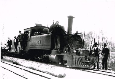
... In 1898 a recommendation for a railway of 2 ft 6 in gauge... Standing Committee on Railways, to cost $138,000. Construction ...In 1898 a recommendation for a railway of 2 ft 6 in gauge was handed down by the Parliamentary Standing Committee on Railways, to cost $138,000. Construction began in 1900. About 100 men were engaged in laying and ballasting the track while others, not included in the 100, formed the earthworks, culverts and bridges. Locomotive operations initially were two 2-6-2 Tank engines of the narrow gauge A class, dubbed "Coffee Pots", and these were used on the work trains between 1900 and 1902. Because of the lengthy periods of waiting time required to unload sleepers and rails or to load ballast meant that a handy replenishment of coal and water supply was necessary. With earthworks specified to the bare minimum landslips in the narrow cuttings were frequent so a repairer was stationed in each length to deal quickly with minor slips until 1904 when the cuttings were widened.B/W. The driver and seven other men on locomotive 5A and its flat cars at Beech Forest during construction of the line in c.1902. beech forest; railways; loco 5a; -
 Puffing Billy Railway
TACL - Erica State Sawmill Rail Tractor, 1928
... of the Victorian Railways. Its construction by the Forests Commission...Puffing Billy Railway 1 old monbulk road Belgrave yarra ...TACL-Tractor Appliance Company Limited TACL rail tractors manufactured by Malcolm Moore of Port Melbourne Located in the Parishes of Moondarra and Telbit, Gippsland, the tramway terminated at Collins Siding on the Moe Walhalla 2'6"gauge branch of the Victorian Railways. Its construction by the Forests Commission of Victoria was to facilitate the extraction of timber from the Southern and Western slopes of Mount Erica and to replace the outlet tramways destroyed during the disastrous forest fires of February 1926. Tyers Valley Tramway The line, following the Eastern arm of the river, passed Ingrams Siding (7m.) to terminate at a forest area, known as "Ten Acre Block", 8m. 60c. from Collins Siding. The western branch of the line followed the Western Tyers Valley to Growlers Creek, 13m. 40c. from Collins Siding. THE T.A.C.L. TRACTORS at Tyers Valley tramway. On the 19th January 1928, T.A.C.L. locomotive, purchased from Tractor Appliance Co. Ltd. (Malcolm Moore), was delivered. This unit had a 20 h.p. Fordson engine coupled by a chain drive to the two axles, providing a tractive effort of approx. 2000lbs. Wheelbase was 5’ and weight was four tons. It was intended that the two tractor locomotives, working with the grade, would deliver timber from the branch lines to Tyers Junction, from which place it would be steam hauled out to the Collins Siding transfer point. Following a breakdown of the steam locomotive, haulage during the early months of 1928 was carried out by the T.A.C.L. unit, supplemented by the Nattrass, which was, by this time, becoming unreliable. During April 1928, after ensuring that no suitable locomotive was available in Australia, an order was placed with the Climax Manufacturing Co., U.S.A. for the supply of a geared locomotive. A second T.A.C.L. engine was purchased during May and, on the 27th, the local mill owners, having obtained running rights on the tramway, commenced haulage with the Harman. The three tractor units worked the branch lines and transported ballast, whilst the Harman hauled the timber to Collins Siding in rakes of eight trucks (56 tons). The weekly loading of the line for the first, second and third weeks were 54, 62 and 71 trucks respectively. info from : http://www.nmra.org.au/tyersvalley/Tyers-Tram.html Historic - Industrial Narrow gauge Railway - Timber working - Rail Tractor used by the the Forests Commission of Victoria on the Tyers Valley TramwayRail Tractor with Fordson engine coupled by a chain drive to the two axles - made of steel and wrought ironerica sawmill, puffing billy, tacl, rail tractor, tractor appliance co. ltd. (malcolm moore), industrial narrow gauge railway, tyers valley tramway, forests commission of victoria -
 Puffing Billy Railway
Axle Box Cover - Tasmanian Main Line Co, 1874
... with the Launceston and Western Railway (L.W.R.) It started construction... Railway (L.W.R.) It started construction of a 3' 6" gauge line ...Axle box cover from a Tasmanian Main Line Railway rail vehicle from 1874 The Tasmanian Main Line Railway Company (T.M.R.L.) was a privately owned railway company that existed in Tasmania from 1872 to 1890. The company were the first operators of rail services between Hobart and Launceston, where it connected with the Launceston and Western Railway (L.W.R.) It started construction of a 3' 6" gauge line between Hobart and Launceston in 1873 which was completed in December 1875. and was officially opened on 1 November 1876. The route of the railway was selected largely as a result of vocal local interests and accordingly traversed some reasonably unfavorable topography, particularly in the southern section. Because the TMLR had limited finances, the line was built to the narrow (1067 mm) gauge and included long sections of steep gradients and sharp curves. The final eighteen kilometres of the route from Western Junction to Launceston used the existing broad gauge alignment of the Launceston and Western Railway, with a third rail being laid for use by the narrow gauge trains A close but uncomfortable relationship with the Government was resolved in 1890 with the purchase of the company's assets by the Crown and their incorporation into the Tasmanian Government Railways on 1 October 1890. Historic early Tasmanian Main Line Railway - Vehicle Axel Box cover Axle box cover from a Tasmanian Main Line rail vehicle from 1874.T.M.L.R - 1874 -axle, tasmanian main line railway, axle box, tasmania, main line, -
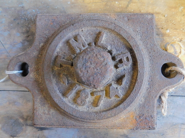
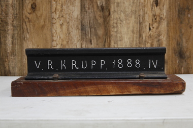 Puffing Billy Railway
V. R. Krupp 1888. IV. Rail, 1888
... with Victorian Railways for railway and canal construction and supply...Puffing Billy Railway 1 old monbulk road Belgrave yarra ...60lbs rail that was used throughout the Victorian rail network. In 1887 Gibbs, Bright and Co. had a contract with Victorian Railways for railway and canal construction and supply of Krupp Rails. Gibbs, Bright and Co were merchant bankers and shipping agents and merchants who where also Directors of the GWR ( Great Western Railway ) and the Ship The "Great Britain" in England Gibbs, Bright and Company had principally been involved in shipping and trading, mainly in the West Indies, but following the discovery of gold in Victoria they established an office in Melbourne and soon became one of the leading shipping agents and merchants in the Colony. They expanded into passenger shipping and soon established offices in Brisbane, Sydney, Newcastle, Adelaide and Perth as well as launching passenger services between England, Mauritius and New Zealand. Gibbs, Bright also held a number of financial agencies from British mortgage, finance and investment companies as well as representing several British insurance companies in Australia. In addition they conducted a growing import business as well as an export business that included livestock, dairy produce, wool and flour. Also the company played a substantial part in the development of Australia's mineral resources, starting with lead in 1895, and later venturing into tin, gold, copper, cement and super phosphates. In Australia, after WWI, many of the larger companies were managing their own import and export so Gibbs, Bright and Company tended to focus its Agency business on smaller companies while expanding their interest into other markets such as timber, wire netting, zinc, stevedoring, road transport, marine salvage, gold mining as well as mechanical, structural, electrical and marine engineering. The Company's shipping interests continued to grow as well and still formed a major part of its business. In 1948 the parent company in England took the major step from tradition when they changed the business from a partnership into a private limited company. The name was the same, Antony Gibbs and Sons Limited, and in practice the effect of the change was very little. Some of the firm's branches and departments had already become limited companies and the formation of a parent company simplified the structure. The Australian operation was in time changed to Gibbs Bright & Co Pty Ltd in 1963. In 1848 Alfred Krupp becomes the sole proprietor of the company which from 1850 experiences its first major growth surge. In 1849 his equally talented brother Hermann (1814 - 1879) takes over the hardware factory Metallwarenfabrik in Berndorf near Vienna, which Krupp had established together with Alexander Schöller six years earlier. The factory manufactures cutlery in a rolling process developed by the brothers. Krupp's main products are machinery and machine components made of high-quality cast steel, especially equipment for the railroads, most notably the seamless wheel tire, and from 1859 to an increased extent artillery. To secure raw materials and feedstock for his production, Krupp acquires ore deposits, coal mines and iron works. On Alfred Krupp's death in 1887 the company employs 20,200 people. His great business success is based on the quality of the products, systematic measures to secure sales, the use of new cost-effective steel-making techniques, good organization within the company, and the cultivation of a loyal and highly qualified workforce among other things through an extensive company welfare system. From 1878 August Thyssen starts to get involved in processing the products manufactured by Thyssen & Co., including the fabrication of pipes for gas lines. In 1882 he starts rolling sheet at Styrum, for which two years later he sets up a galvanizing shop. The foundation stone for Maschinenfabrik Thyssen & Co. is laid in 1883 with the purchase of a neighboring mechanical engineering company. In 1891 August Thyssen takes the first step toward creating a vertical company at the Gewerkschaft Deutscher Kaiser coal mine in [Duisburg-]Hamborn, which he expands to an integrated iron and steelmaking plant on the River Rhine. Just before the First World War he starts to expand his group internationally (Netherlands, UK, France, Russia, Mediterranean region, Argentina). info from The company thyssenkrupp - History https://www.thyssenkrupp.com/en/company/history/the-founding-families/alfred-krupp.htmlHistoric - Victorian Railways - Track Rail - made by Krupp in 1888Section of VR Krupp 1888 Rail mounted on a piece of varnished wood. Rail made of ironpuffing billy, krupp, rail, victorian railways -
 Puffing Billy Railway
Double Headed Rail, circa 1872 - 1883
... technologies. Construction dates 1862, Info from Ravenswood Railway... technologies. Construction dates 1862, Info from Ravenswood Railway ...Double Headed Rail from Ravenswood Station Siding which was dismantled circa 1987 the two rails were stored for a time at Maldon before being donated to Puffing Billy Museum Bearing makers marks of Wilson & Cammell - Dronfield- Steel works Wilson & Cammell made Steel rails at their Dronfield Steel Works, in Dronfield, North East Derbyshire, England from 1872 - 1883 Double-headed rail In late 1830s Britain, railway lines had a vast range of different patterns. One of the earliest lines to use double-headed rail was the London and Birmingham Railway, which had offered a prize for the best design. This rail was supported by chairs and the head and foot of the rail had the same profile. The supposed advantage was that, when the head became worn, the rail could be turned over and re-used. In practice, this form of recycling was not very successful as the chair caused dents in the lower surface, and double-headed rail evolved into bullhead rail in which the head was more substantial than the foot. Info from Wikipedia - Rail Profile https://en.wikipedia.org/wiki/Rail_profile The first records of double headed rail being used In Victoria by Victorian Railways was in 1859, the rails, chairs, oak and trenails were imported from UK. After the 1870’s the Victorian Railways went over to using flat bottom rails, but they still needed replacement double headed rail for lines already laid and this continued up to at least 1883 Wilson & Cammell - Dronfield- Steel works Wilson & Cammell made Steel rails at their Dronfield Steel Works, in Dronfield England from 1872 - 1883 Mount Alexander & Murray River Railway The Melbourne, Mount Alexander & Murray River Railway Company received parliamentary assent in February 1853 to build Victoria's first inland railway from Melbourne to Williamstown, and Melbourne to Bendigo and Echuca. Construction commenced in January 1854 with work on a pier at Williamstown but lack of funds slowed progress, eventually prompting the company to sell out to the government. The 100-mile (162 km) section to Bendigo opened in October 1862. Its cost of £35,000 per mile made it the most expensive railway ever built in Australia. In 1864, the line was extended to Echuca, tapping into the booming Murray-Darling paddlesteamer trade. info from Museums Victoria - Victorian Railways https://museumsvictoria.com.au/railways/theme.aspx?lvl=3&IRN=450&gall=456 1863 Ravenswood Station open on the 1st Feb 1863 Victorian Railways - purchased and imported the Rail and Chairs from Raleigh, Dalgleish, White and Co. London Importation of railway plant : abstract of a return to an order of the Legislative Assembly dated 27th June 1860 for - Copies of the advertisements calling for tenders, the names of the tenderers and the accounts and correspondence with Mr Brunel relating thereto GP V 1859/60 no. C 15 http://www.parliament.vic.gov.au/papers/govpub/VPARL1859-60NoC15.pdf Report from the Select Committee upon the Importation of Railway Plant : together with proceedings of the Committee, minutes of evidence and appendix GP V 1859/60 no. D 38 (2.9 MB) http://www.parliament.vic.gov.au/papers/govpub/VPARL1859-60NoD38.pdf Ravenswood Siding When the Victorian Railways were established in 1856 they adopted one of the popular British permanent way standards - heavy 80lb (36.3kg) double-headed rail held up right in cast iron chairs attached to transverse timber sleepers by wooden pegs called trenails. The Ravenswood Railway siding was constructed in 1862 with 12 feet wrought iron double-head rail held in cast iron chairs with Ransom and May patent compressed keys. Trenails held the chairs to the sleepers and the joints were secured in joint chairs. Joints were subsequently joined using fish plates. It formed part of the Melbourne to Echuca rail line, initially known as the Melbourne, Mt Alexander and Murray River Railway. George Christian Derbyshire, the first Engineer-in-Chair of the Victorian Railways was responsible for the design and construction of the works. No new lines were built in Victoria using double-headed rail after 1870. The siding was disconnected from the main line in 1988. The Ravenswood Railway Siding demonstrates the original 1856 philosophy of the Victorian Railways to adopt British permanent way technology. The siding demonstrates significant aspects in the development of permanent way technology in England and Victoria over the period from the 1830's to the 1880's. The chairs in the Ravenswood siding are physical evidence of early railway technology rendered obsolete 120 years ago, namely joint chairs at rail joints and trenails to secure the chairs to the sleepers. The double-headed rail demonstrates an important stage in the evolution of British rail technology in the 1830s. The old fish plates, square headed bolts and square nuts demonstrate the success of fishing the rail joins. The Ravenswood siding demonstrates the earliest form of rail joint technology developed in England, and existing in Australia, the joint chair. In part of the siding the sequence of joint and intermediate chairs is consistent with the 1856 specifications, that sequence is rare with the joints secured in joint chairs. The survival of chairs in this sequence is rare and almost certainly demonstrates that they remained in continuous use at the same location from 1862 to 1988. This remnant of the Ravenswood siding has survived 126 years. The siding has proved to be the most significant of extant remnant double-headed sidings in Victoria, containing a rare combination of early permanent way technologies. Construction dates 1862, Info from Ravenswood Railway Siding Victorian Heritage Database Report http://vhd.heritagecouncil.vic.gov.au/places/4693/download-report The remaining section of this siding is significant at the State and National levels in that it demonstrates the use of chaired rail by the Victorian Railways Department for the Trunk Lines and, more particularly, the following stages in the evolution of this long obsolete method of permanent way construction: a) The use of joint chairs and intermediate chairs at regular intervals inferring that the original wrought iron rail lengths were 12 feet, as is known through documentary sources to have been the case. The survival of chairs in this sequence is unique and almost certainly demonstrates that they have remained in continuous use at the same location and in the same sequence from 1862 to 1988 . b) The use of joint chairs and intermediate chairs designed for use with trenails. c) The use of later intermediate chairs designed for use with steel pins and the use of fished joints with steel double head chaired rail, representing a second method of constructing the permanent way using chaired rail technology. info from Ravenswood Siding - Melbourne/Echuca Railway Line - Victorian Heritage Database Report http://vhd.heritagecouncil.vic.gov.au/places/70103/download-report Addition to Citation for Melbourne to EchucaRailway Line 1/10/1990 Double Head Rail The surviving lengths of double head rail with chairs on this railway compare with one surviving similar remnant on the Geelong to Ballarat railway and are representative of permanent way construction techniques applied exclusively to the two trunk railways of the 1860's. In this respect they are rare survivors and may be unique at the national level and of technical importance at the international level to the extent that they enhance contemporary understanding of early railway building technology. Surviving lengths of chaired double head rail survive at Kyneton, Ravenswood and Bendigo on this railway and include a number of different types of cast iron intermediate and joint chairs with hardwood keys and metal pins. The Ravenswood siding is of special significance for the diversity of chair types and for the sequence of chairs recalling rail lengths known to be associated with construction of the line in 1862. Construction of the Railway Tenders closed on 24 March 1858 with no less than 133 tenders being received. A contract was let to Cornish and Bruce for £3,356,937 to commence work on 1 June 1858 and complete the line by 31 July 1861. Cornish and Bruce made quick early progress with the Melbourne to Sunbury section being officially opened on 13 January 1859. The line was officially opened to Bendigo (Sandhurst) on 20 October 1862 by the Governor of Victoria, Sir Henry Barkly. A great banquet was held for 800 guests and this was followed by a grand ball. The extension of the line to Echuca was a relatively simple matter as that part of the line was across plain country without any significant engineering challenges. Tenders were called for the work in 1863 and the work was completed in 1864 by contractors Collier and Barry Apart from the line contractors, other firms directly involved were J Shire law and Co (sleepers), R Fulton, Langlands Brothers and Co, William Crossley (water supply), B Moreland, Langlands Brothers and Co (platelayers lorries), E Chambers (iron pins, traversers), Miller and McQuinstan (luggage vans and steam engines) and various contractors for building works. Info from Engineers Australia Engineering Heritage Victoria Nomination for Recognition under the Engineering Heritage Australia Heritage Recognition Program for the Goldfields Railways - Melbourne , Bendigo & Echuca Railway Page 25 - .2.9.2 Statement from National Trust of Australia (Victoria) Listing number B5323 for Mt Alexander/Murray Valley Rail Line: Page 69 - Theme 3 https://www.engineersaustralia.org.au/portal/system/files/engineering-heritage-australia/nomination-title/Melbourne_%20Bendigo_Echuca%20Railway%20Nomination.pdf The Melbourne, Mount Alexander and Murray River Railway Company was a railway company in Victoria, Australia. It was established on 8 February 1853 to build a railway from Melbourne to Echuca on the Victorian-NSW border and a branch railway to Williamstown. The company struggled to make any progress and on 23 May 1856, the colonial Government took over the Company and it became part of the newly established Department of Railways, part of the Board of Land and Works. The Department of Railways became Victorian Railways in 1859. Construction of the Bendigo line commenced in 1858, but this private consortium also met with financial difficulties when it was unable to raise sufficient funds, and was bought out by the Victorian colonial government. The design work was then taken over by Captain Andrew Clarke, R. E., Surveyor-General of Victoria, with bridge designs completed by Bryson and O'Hara The contract for the first stage of the line from Footscray to Sandhurst (now Bendigo), was let to Cornish and Bruce for £3,356,937.2s.2d ($6.714 million) with work commencing on 1 June 1858. Completion of the permanent way was to be by 31 July 1861 https://en.wikipedia.org/wiki/Melbourne,_Mount_Alexander_and_Murray_River_Railway_Company Victorian Railways - purchased and imported the Rail and Chairs from Raleigh, Dalgleish, White and Co. London Importation of railway plant : abstract of a return to an order of the Legislative Assembly dated 27th June 1860 for - Copies of the advertisements calling for tenders, the names of the tenderers and the accounts and correspondence with Mr Brunel relating thereto GP V 1859/60 no. C 15 http://www.parliament.vic.gov.au/papers/govpub/VPARL1859-60NoC15.pdf Report from the Select Committee upon the Importation of Railway Plant : together with proceedings of the Committee, minutes of evidence and appendix GP V 1859/60 no. D 38 (2.9 MB) http://www.parliament.vic.gov.au/papers/govpub/VPARL1859-60NoD38.pdf Victorian Railways : report of the Board of Land and Works November 1862 GP V 1862/63 no. 21 (2.8 MB) https://www.parliament.vic.gov.au/papers/govpub/VPARL1862-63No21.pdfHistoric - Victorian Railways - Double Headed rail Ravenswood Railway Station and Siding Victorian Heritage Database Reports Victorian Heritage Register VHR H1100 Victorian Heritage Register VHR H1786 National Trust VHR H1100 Mount Alexander and Murray River Rail way Line National Trust2 rail lengths of Double Headed Rail made of Iron makers marks : Wilson & Cammell - Dronfield - Steel and 20 joint chairs with metal rail pins Makers mark Wilson & Cammell - Dronfield - Steel (possible date 187? very hard to read ) puffing billy, double headed rail, wilson & cammell - dronfield - steel works, ravenswood station siding, melbourne to echuca rail line, initially known as the melbourne, mt alexander and murray river railway. -
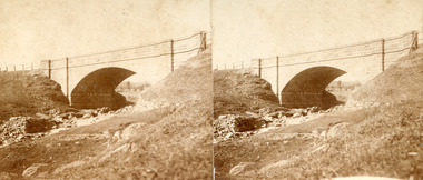 The Beechworth Burke Museum
Photograph - Stereoscopic Photograph, Unknown c1875
Depicted in the photograph is Newtown Bridge or the Newtown Falls Bridge, in Beechworth, Victoria. Noted for its location, detailed craftsmanship and stonemasonry by Scottish stonemasons the Newtown Bridge was built in the 19th century provincial town of Beechworth (completed in 1875). The bridge was built over Spring Creek, spanning 6.3 meters wide and 24.8 meters tall. Beechworth held a distinct role in the administrative and commercial management of Victoria's north-eastern goldfields, with many objects and structures still well preserved from the towns establishment. The bridge indicates the growth of the town, replacing a previous timber structure as well as its association to the mining activity in the area and the rapid increase in Australia's economy that led to investment and development of roads and railways. The local granite used in the construction of the single arch Newtown Bridge makes the bridge and other buildings made with the granite unique to the area, the honey-toned material distinct to Beechworth. This photograph is historically significant as it provides insight into the industrial development of Beechworth and the surrounding area, contributed to by the goldfields. The photograph further captures the representation of vernacular engineering traditions and Scottish stonemasonry.Two sepia-toned rectangular photographs featuring a bridge in the background printed on matte photographic paper mounted on card.Reverse: 97.2324/ Newtown Bridge/ Beechworthbridge, newtown beechworth, newtown bridge, newtown, beechworth, beechworth falls bridge, beechworth mining district, spring creek, -
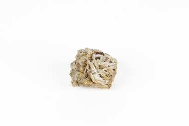 The Beechworth Burke Museum
Geological specimen - Cerussite, Unknown c.1890s
Named in 1845 by Wilhelm Karl von Haidinger cerussite takes its name from the Latin cerussa, meaning 'white lead'. When viewed under certain lighting conditions cerussite gives of fire and rainbow-like colours (due to its high dispersion) and it is quite sought after by geological collectors for this very reason. Cerussite is usually found in the oxidised zone of lead ore deposits. It is a very common weathering product of galena and other lead ore minerals. It is a secondary mineral, meaning it forms as a result of the alteration of pre-existing minerals in the Earth’s crust. The presence of lead in cerussite makes it potentially toxic. Historically, it has been an important source of lead, which has numerous industrial applications, including in batteries, construction materials, and radiation shielding. Cerussite has a crystal structure that belongs to the orthorhombic crystal system. Its crystal structure is characterized by a three-dimensional arrangement of atoms in a repeating pattern. The crystal lattice of cerussite consists of interconnected lead (Pb) and carbonate (CO3) ions. This crystal structure is visible in the specimen. This specimen was found in Dundas (formerly Mount Dundas), a historical mining locality, mineral field and railway located on the western foothills of the West Coast Range in Western Tasmania. During the 1890s Dundas swelled in numbers however it is now lost in a temperate rainforest and its population is now 2. The present Dundas Extended mine, about 1.5 km east of Dundas is presently worked for specimen material.Faceted cerussite gems are considered rare and valuable, given the softness of the mineral. This item is not a faceted gem however its historical and scientific research potential give it significance; mined in an Australian township, this cerussite could shed light on the now lost history of Dundas and the mining that occurred there. Additionally, the uses of this mineral in historical industrial processes give it scientific significance. Such knowledge can add to understandings of the geographical and geological nature of Western Tasmania and allow for further study of Australian geological specimens. A small lead carbonite mineral with shades of cream, white and brown throughout, flaky shards of white at base. CERUSSITE / (lead carbonite) / Locality: Dundas, W. Tasmaniadundas, tasmania, cerussite, lead, orthorhombic, geology, minerals, mining -
 Orbost & District Historical Society
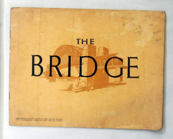
book, The Bridge, 1930's
This book was written by Dr J. J. C. Bradfield, (John Job Crew), 1867-1943. Dr JJC Bradfield was a visionary Australian engineer who worked with enormous energy and vision to build the infrastructure which he foresaw that Sydney would need as it grew. As early as 1903 Bradfield was making the case for the Sydney Harbour Bridge, in his presidential address as President of the Sydney University Engineering Society. Bradfield’s proposal — at that stage for a cantilever bridge between Dawes Point and Milsons Point — won the committee’s support and they recommended it be accepted. However, the First World War put a stop to these plans. While a bill to authorise the project passed the lower house of the NSW parliament in 1916, it failed to pass the upper house, on the grounds that funds should not be diverted from the war effort. With the war over, in 1922 the Sydney Harbour Bridge Act was passed by the NSW Parliament. The Sydney Harbour Bridge was officially opened in 1932 after Museum and St James railway stations were built. This book was written from the story broadcast by Dr. J.J.C. Bradfield. This item is a useful reference tool.A staple soft cover 16 pp booklet with a buff coloured cover. It has a sketch of the Sydney Harbour Bridge behind the title "The Bridge" in dark brown print. It contains information and photographs of the history and construction of Sydney Harbour Bridge.sydney-harbour-bridge bradfield-dr-j-j-c -
 Orbost & District Historical Society
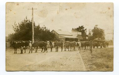
black and white photograph, 1911
... World War and the construction of the railway line from... World War and the construction of the railway line from ...This photo shows Jas Lynn of Orbost driving a team of bullocks pulling a large cart of maize. They are taking it to the fisherman's Wharf in Lakes Entrance. Maize has been grown on the Orbost flats since the late 19th century. Transport was always an obstacle to economic sucess. For a few years prior to the First World War and the construction of the railway line from Bairnsdale to Orbost, a lot of maize was carted by horse and bullock teams to Lakes Entrance for transhipment to the Melbourne market. At that .time yields of 90 to 100 bushels of maize were quite a common occurrence. James Lynn, a member of the East Gippsland Maize Board, farmed at Jarrahmond.This photograph is associated with the large maize growing industry in the Orbost region. A black / white photograph of a bullock team pulling a large, loaded cart. It is being driven by a man standing on the side of the road, holding a whip. In the background are houses and a telegraph pole.on back - " Carting maize to Lakes Entrance in 1911."transport-bullocks maize-orbost lynn-james -
 Orbost & District Historical Society
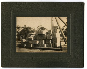
black and white photograph, first half 20th century
This photograph shows marble waiting to be loaded on the train at Nowa Nowa Station to be sent to Melbourne for the Shrine of Remembrance and Australia Housee in London. In the early 1900s black marble was being mined in the Bruthen district. Some was used for the Shrine of Remembrance in Melbourne and Australia House in London. 900 tonnes were shipped to London to be included in the construction of Australia House.Marble quarrying has been a significant part of the history of Buchan in East Gippsland. Its inclusion in the Shrine of Remembrance War Memorial is noteworthy.A black / white photograph mounted on a dark grey buff card. It shows a man and a dog sitting next to slabs of stacked marble.on back - " Marble stacked at Nowa Nowa Rail Station for Australia House."buchan-marble australia-house shrine-of-remembrance nowa-nowa-railway geology -
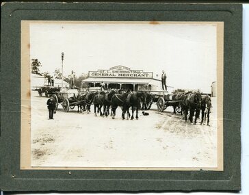 Orbost & District Historical Society
black and white photograph, early 20th century
This photograph shows Buchan marble being transported by horse and wagon to Nowa Nowa Railway Station. Lnidsay Cameron is the driver on the right. In the background is the Commercial Store of T. L. Sherrington, General Merchant, Bruthen. In the early 1900s black marble was being mined in the Bruthen district. Some was used for the Shrine of Remembrance in Melbourne and Australia House in London. 900 tonnes were shipped to London to be included in the construction of Australia House. Marble quarrying has been a significant part of the history of Buchan in East Gippsland. Its inclusion in the Shrine of Remembrance War Memorial and Australia House in London is noteworthy.A black / white photograph on a grey buff card. it is of four horse drawn wagons in front of a general store - "T L Sherrington General Merchant". There are five men standing on the trays and a man in a suit and hat holding a Gladstone bag is standing front left. a dog is lying on the ground between the wagons. The wagons are carrying large slabs of marble.on back - " Marble passing through Bruthen on way to railway"buchan-marble geology cameron-lindsay transport-rail transport-horse-drawn -
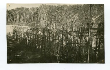
 Orbost & District Historical Society
black and white photograph, 1916
This photograph shows the pile drivers at work in the construction of the viaduct across the Snowy River flats. The Snowy River Floodplain Railway Bridges, two sequential and exceptionally long and low timber railway bridges on the Snowy River floodplain just west of Orbost, were built in 1916, and provided the original terminus point for the Bairnsdale-Orbost railway. The bridges are 770 metres and 183 metres long respectively. The shorter bridge is of uniformly 4.57 metre timber-beam construction, and has a sweeping curve in its deck. The longer bridge has a combination of 4.57 metre and 6.1 metrespans, and two 3.66 metre spans. The bridges are constructed from 'Southern Mahogany', Eucalyptus Botryoides, which grew along the coast east of Bairnsdale. The Snowy floodplain bridges were initially built in the context of an early twentieth-century interest in American-style 'Developmental Railways', designed to open remote areas to closer settlement, even if that meant running at a loss. The line was closed in August 1987. (information from Victorian Heritage Database)This item is associated with the history of the Orbost-Bairnsdale railway line and therefore reflects the role that the rail line played in the social and economic history of Orbost.A black / white photograph of the farming flats at Orbost during the construction of the East Gippsland railway.orbost-railway east-gippsland-railway viaduct-orbost transport railway -
 Ringwood and District Historical Society
Photograph, Duplication of the five-kilometre section of railway line between Ringwood and Croydon in 1983
Digital scanFrom Vicrail News magazine, April 1983. “Duplication of the five-kilometre section of line between Ringwood and Croydon is on the way. Several major works will be undertaken over the next few months so the two tracks can be brought into service later this year. Intensive work on this section follows completion of duplication works between Ringwood and Bayswater on the Belgrave line last December. The completion of this 5.17 kilometre section between Ringwood and Bayswater means that this Belgrave line is now duplicated as far out as Ferntree Gully. Commuters using the Belgrave line now have an improved service with the intro duction in January of an additional evening peak train to Upper Ferntree Gully, two additional peak hour services in the morning from both Belgrave and Upper Ferntree Gully, and with the additional tracks delays on one line will not affect trains travelling in the opposite direction. Commenting on the completion of this stretch of track the Minister of Transport, Mr. Crabb, said a further improvement had been made with the commissioning of boom barriers at the Bedford Road level crossing in Ringwood. "The installation is part of the State Government's $9.4 million four-year plan to equip 70 dangerous level crossings throughout the State with boom barriers", he said. Works to be carried out on the Ringwood/ Croydon section include laying of new track, station works at Croydon and installation of boom barriers at East Ringwood. Already completed are bridge works to cater for double tracks at both Mt. Dandenong and Eastfield Roads between Croydon and East Ringwood and construction of an island platform at East Ringwood station. At several locations alignment of the existing track will be slightly relocated. The new line is being constructed with concrete sleepers and heavyweight rails. The existing line will also be reconstructed using these heavy 60kg per metre rails. Engineering works to be completed include installation of overhead wiring necessary to supply power to trains, construction of two new station buildings and a new platform at Croydon, provision of boom barriers, and pedestrian boom barriers at Dublin Road level crossing. East Ringwood, and replacement of existing timber overhead wire support structures with steel structures. Other works in this program included installation of boom barriers at Bedford Road, Ringwood and Scoresby Road, Bayswater and provision of a new platform for trains going to Melbourne and Heathmont. A new timetable on the Lilydale and Belgrave lines will commence when the Ringwood—Croydon duplication track work is completed.” -
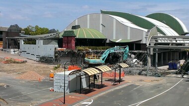
 Ringwood and District Historical Society
Photograph, Removal of car park at former Adelaide Street, Ringwood. Preparation for construction work beginning at the Ringwood Railway Station and Stage 5 of Eastland circa 2014
Photographs taken by Terry Ahern in 2008-2014, member of RDHS -
 Ringwood and District Historical Society
Photograph, Removal of Ringwood library and surrounds. Preparation for construction work beginning at the Ringwood Railway Station and Stage 5 of Eastland circa 2014
Photographs taken by Terry Ahern in 2008-2014, member of RDHS -
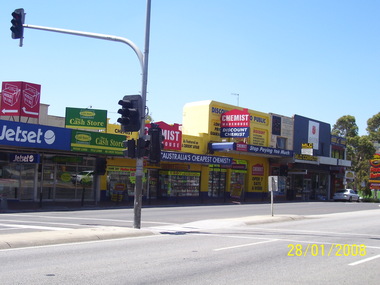 Ringwood and District Historical Society
Photograph, Former shops to the east of Melbourne Street in January 2008. Knocked down in later preparation for construction work beginning at the Ringwood Railway Station and Stage 5 of Eastland circa 2014
Photographs taken by Terry Ahern in 2008-2014, member of RDHS -
 Orbost & District Historical Society
Photograph - Photograph. black + white
... in showing the bridge under construction. construction 1916 railway ...The Stony Creek Trestle Bridge was built in 1916 when the existing rail line from Melbourne to Bairnsdale was extended to Orbost. This 97km Bairnsdale to Orbost extension through rugged terrain was reputed to have been the most difficult rail project undertaken in Victoria. In service for over 60 years the bridge was damaged by bushfire in 1980, with the last train crossing in 1987. At 247m long and 20m high, it is the largest standing bridge of its kind in the State, and is listed on the Register of Historic Sites. Built of red ironbark and grey box timber, it is a fine example of the early engineering skills that utilised the resources and materials found on site. (More information Newsletter July 2013)Built during the period 1914-16, of Gippsland Grey Box and Red Ironbark, the Stoney Creek bridge on the East Gippsland Railway is a fine example of early engineering skilll , being constructed without the aid of any of the modern machinery available today. This is a rare photograph and of high significance in showing the bridge under construction.Landscape format black + white photograph (unframed). Four pin holes in each corner, tear to top left quadrant and fold / crease top to bottom in centre of image.construction, 1916, railway bridge, timber industry, trestle construction, stony creek bridge, east gippsland, bairnsdale to orbost line -
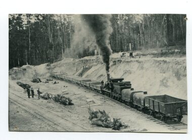 Orbost & District Historical Society
black and white photograph, late 19th / early 20th century
This is a photograph of the gravel pit at Newmerella, near Orbost. This pit was used during the construction of the Orbost to Bairnsdale Railway line.This item is associated with the history of the Orbost-Bairnsdale railway line and therefore reflects the role that the rail line played in the social and economic history of Orbost. The Bairnsdale-Orbost railway was opened in 1916 to serve the agricultural and timber industry. Because of the decline in traffic and heavy operating costs, the line was finally closed in August, 1987. A black / white photograph of a small steam engine with open freight wagons at a gravel pit. There are some men watching. -
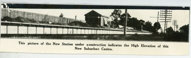 Ringwood and District Historical Society
Photograph, Heathmont Railway Station - building stage
Black and white photograph showing new station under construction - Circa 1920's See also Registration No 4706 -similar photo. PKW - i . Heathmont Railway Station -building stage"written on front of photograph" This picture of the New Station under construction indicates the High Elevation of this New Suburban Centre. -
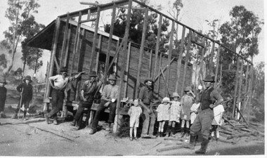 Upper Yarra Museum
Negative Photographic Reproduction, Warburton East, Primary School being demolished, 1988
Extract Local residents often had to provide their own school. These men with a little help from their offspring, are pulling down the Old East Warburton School to make way for a new one. Page 73, " The Upper Yarra An Illustrated History" by Brian Carroll, The Shire of Upper Yarra, 1988Warburton East, Primary School under construction Negative Black white Scanned at 600 dpi. Printed album presented to Upper Yarra Historical Society, compiled by R. Crowleyschool, east warburton -
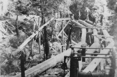 Upper Yarra Museum
Negative Photographic Reproduction, A tramway bridge under construction, 1910 Mr Hansen & Andy
A tramway bridge under construction, 1910 Mr Hansen & Andy Negative Black white. Scanned at 600 dpitramway bridge construction curved hand winch mr hanson andy 1910 -
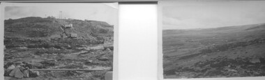 Kiewa Valley Historical Society
9 small black and white Photographs, c1950
These photos were taken in 1950 by Bill Peel who was appointed as a secondary teacher at the newly built Mt. Beauty School in January 1950. He was the entire secondary staff for an enrolment of 4 students in Form 3 (year 9), 9 in Form 2 and 25 in Form 1. There were also 4 primary teachers as the school combined both primary and secondary education. He was provided with accommodation at the staff hostel (Mt. Beauty Chalet). A autobiography is also enclosed describing his 12 months as a teacher in Mt. Beauty.These photographs give a clear picture of the stage of construction of housing in both Bogong Village and Mt. Beauty in 1950. Large workmen's camps are clearly visible at both sites. Construction at Rocky Valley Dam site has just begun. They are of historical significance. The autobiography gives an excellent insight into conditions teachers faced in small country schools;Nine small black and white photographs3 photos stamped with "1 856", 4 photos stamped with "210, 2 photos are identified with hand written inscriptions, in ink, on the back - "Railway Bridge Bright '50" and second photo "Lake Catani '50" also 'Kodak' circular stamp on back of both.mt. beauty, bogong, acccommodation, education, rocky valley -
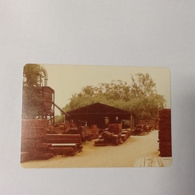 Port of Echuca
Colour photograph, 1979
Discussed in book : Echuca: A centenary history by Susan Priestley, pp.21, 38, 45, 66, 114-123, 126, 174 R.J.Evans established this mill on the banks of the Murray River, Echuca in 1923 & it operated until 1980. The mill later became a tourist attraction, Red Gum Works, continuing to cut timber until it was taken over by The Port of Echuca as a display (Port of Echuca booklet, 2005 ed., p. 32)Sawmilling was a very important industry for Echuca. At its peak in Echuca in about 1877 there were between 1000-1500 men employed in the industry (Priestley, Susan. 1965, p.118). Red gum was sourced from the forests along the Murray river. It is a very strong timber suitable for bridge & wharf building, construction works as well as housing and especially for sleepers for the railways. Mills relied on government contracts especially for the sleepers. Colour photograph (post-card size) of red gum sawmill on the Port of Echcua. Photograph is taken looking north.Printed on reverse: "this paper manufactured by Kodak."echuca, port of echuca, sawmilling, evans, r. j., red gum works -
 Eltham District Historical Society Inc
Photograph - Digital Photograph, Alan King, Former Police Residence, 728 Main Road, Eltham, 28 December 2007
The institutions of law and order in Colonial Victoria included the police, courts and prisons. The 1852 report of the Snodgrass Select Committee appointed to "identify the policing needs of the colony” noted there existed seven independent police forces that did not co-operate or regularly communicate. Following the committee's report all these police entities were merged into the Victoria Police, founded on 8 January 1853, to implement law and order responsibilities throughout the Colony of Victoria. The Eltham Courthouse (1860) and adjacent Police Residence (1859) formed a justice precinct established in the immediate aftermath of the 1852 police inquiry and the effects of the gold rush. The physical presence of these buildings, in the centre of the early Eltham township, defined centralised control over law and order. In the early days the Police Constable in charge would conduct his duties travelling around the district by horse; a stable was located at the rear of the residence. At times the horse would be grazed on the paddocks across the road. Horseshoes were forged by the blacksmith beside the Courthouse on the high side of “Policeman’s Hill”. Along with the stable, there was a two-cell bluestone lockup where prisoners were held awaiting trial in the adjacent Courthouse. Their meals were usually provided by the policeman’s wife or from the hotel just up the road. With the arrival of the railway in 1902 the town centre gradually shifted towards the railway station. The Police Station and operations were moved into the town centre in 1961 to a renovated house in Pryor Street, which was later replaced by the current Police Station. From 1961-1981 the residence was occupied by the Vermin and Noxious Weeds Destruction Section of the Department of Crown Lands and Survey. Prior to August 1967 the former Police Station was dragged to the rear of Police Residence to make way for the construction of a driveway and access from Main Road. The building was placed on the site of a former Scullery and modified for Lands Department use. In 1981 the Shire of Eltham took over management of the former Police Residence in Eltham. It remained unoccupied for a period whilst its future was discussed in Council. It was then used for a community job creation scheme until 1985. In 1985 the Shire of Eltham Parks and Environment occupied the residence. Council improved the driveway but later added a second rear access from Brougham Street due to the dangerous nature of the Main Road entrance. Additionally, a rear toilet facility between the Police Residence and the relocated former Police Station, which was doubling up as a lunchroom. Council also commenced discussions to re-establish a replica Police Station. Around November 1986 the former Police Station was demolished; believed to have been suffering termite damage. About 1989, after some years of discussion, a replica Police Station was built, based on photographs, to act as a lunchroom and meeting room for the Parks and Environment staff and volunteers doing community service. In 1996 Eltham District Historical Society held discussions with Nillumbik Shire Council commissioners throughout the year regarding a home for the Society. A proposal was put forward by the Society in October to occupy the former Police Residence. In March 1997 Eltham District Historical Society gained access to former Police Residence and on July 12, 1998, moved into its Local History Centre. In July 2018, Eltham District Historical Society gained access to the replica Police Station (which had been used as a music library and storage for the Eltham Concert Band) for use as part of regular heritage tours for schools and community-based groups. Covered under Heritage Overlay, Nillumbik Planning Scheme. Published: Nillumbik Now and Then / Marguerite Marshall 2008; photographs Alan King with Marguerite Marshall.; p65This collection of almost 130 photos about places and people within the Shire of Nillumbik, an urban and rural municipality in Melbourne's north, contributes to an understanding of the history of the Shire. Published in 2008 immediately prior to the Black Saturday bushfires of February 7, 2009, it documents sites that were impacted, and in some cases destroyed by the fires. It includes photographs taken especially for the publication, creating a unique time capsule representing the Shire in the early 21st century. It remains the most recent comprehenesive publication devoted to the Shire's history connecting local residents to the past. nillumbik now and then (marshall-king) collection, eltham, main road, eltham district historical society, eltham justice precinct, little eltham, local history centre, police residence, police station -
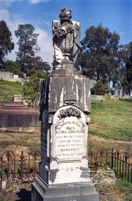 Eltham District Historical Society Inc
Negative - Photograph, Harry Gilham, Grave of Alfred and Margaret Armstrong, Eltham Cemetery, Victoria, Sep 2009
Alfred Patrick Armstrong was born in England in 1825 and was employed under the renowned Isambard Kingdom Brunel as a civil engineer during the construction of the Great Western Railway and the South Wales Railway. He came to Melbourne in 1852 and purchased property in Eltham. He became a mining surveyor and was Inspector of Mines and the Mining Registrar for the St Andrews Division of the Castlemaine Mining District. In 1855, he chaired a meeting calling for a bridge to be erected across the Yarra River between Eltham and Temple Stow. He was registered as an innkeeper in 1858, was a recognised collector of the £110 raised for the building of the first building of State School No. 209 (Eltham Primary) and was a Trustee for the Church of England site on the Eltham Cemetery Trust in 1860. He was elected to the Eltham District Road Board (forerunner of Eltham Shire Council) from 1867 to 1871 and then served as an Eltham Shire Councillor from 1871 to 1878 (including Shire President in 1873). Margaret Armstrong to whom he was married in 1854 at St Pauls Church, Melbourne, died on the 27th March 1887. Alfred died in 1893, having been in ill health for some time, and is buried in Eltham Cemetery with his wife Margaret. The monument features a tall pillar capped with a draped urn: a symbol of death. In Loving Memory of Alfred Armstrong Died May 27tth 1893 Aged 68 years Also of his wife Margaret Died March 27th 1887 Aged 63 years This burial site is of special interest as the monument has the tallest pillar-a vase-a draped cloth top (unfulfilled life) and additional panels of names around the sides and the base, which include: Ada Gertrude Armstrong, beloved daughter of Alfred & Margaret Armstrong, died May 30th 1878, aged 21 years Mary Armstrong, beloved mother to Alfred Armstrong, died April 10th, 1886 aged 82 years Arthur Vivian Harrison, died 4th Nov. 1899, aged 8 years Arthur Reynolds Stockwood Armstrong, son of Alfred Armstrong, died 4th Nov. 1908, aged 43 years Laura Augusta Harrison nee Armstrong, died 26th July 1921, aged 64 yearsRoll of 35mm colour negative film, 6 stripsKodak GC 400-9eltham cemetery, gravestones, alfred armstrong, margaret armstrong, ada gertrude armstrong, arthur reynolds stockwood armstrong, arthur vivian harrison, laura augusta harrison (nee armstrong), mary armstrong -
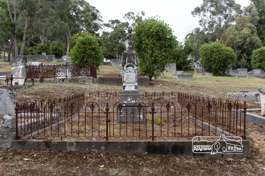 Eltham District Historical Society Inc
Photograph, Peter Pidgeon, Grave of Alfred and Margaret Armstrong, Eltham Cemetery, Victoria, 5 April 2021
Alfred Patrick Armstrong was born in England in 1825 and was employed under the renowned Isambard Kingdom Brunel as a civil engineer during the construction of the Great Western Railway and the South Wales Railway. He came to Melbourne in 1852 and purchased property in Eltham. He became a mining surveyor and was Inspector of Mines and the Mining Registrar for the St Andrews Division of the Castlemaine Mining District. In 1855, he chaired a meeting calling for a bridge to be erected across the Yarra River between Eltham and Temple Stow. He was registered as an innkeeper in 1858, was a recognised collector of the £110 raised for the building of the first building of State School No. 209 (Eltham Primary) and was a Trustee for the Church of England site on the Eltham Cemetery Trust in 1860. He was elected to the Eltham District Road Board (forerunner of Eltham Shire Council) from 1867 to 1871 and then served as an Eltham Shire Councillor from 1871 to 1878 (including Shire President in 1873). Margaret Armstrong to whom he was married in 1854 at St Pauls Church, Melbourne, died on the 27th March 1887. Alfred died in 1893, having been in ill health for some time, and is buried in Eltham Cemetery with his wife Margaret. The monument features a tall pillar capped with a draped urn: a symbol of death. In Loving Memory of Alfred Armstrong Died May 27tth 1893 Aged 68 years Also of his wife Margaret Died March 27th 1887 Aged 63 years This burial site is of special interest as the monument has the tallest pillar-a vase-a draped cloth top (unfulfilled life) and additional panels of names around the sides and the base, which include: Ada Gertrude Armstrong, beloved daughter of Alfred & Margaret Armstrong, died May 30th 1878, aged 21 years Mary Armstrong, beloved mother to Alfred Armstrong, died April 10th, 1886 aged 82 years Arthur Vivian Harrison, died 4th Nov. 1899, aged 8 years Arthur Reynolds Stockwood Armstrong, son of Alfred Armstrong, died 4th Nov. 1908, aged 43 years Laura Augusta Harrison nee Armstrong, died 26th July 1921, aged 64 yearsBorn Digitaleltham cemetery, gravestones, ada gertrude armstrong, alfred armstrong, arthur reynolds stockwood armstrong, arthur vivian harrison, laura augusta harrison (nee armstrong), margaret armstrong, mary armstrong