Showing 408 items
matching victoria avenue
-
 Lakes Entrance Regional Historical Society (operating as Lakes Entrance History Centre & Museum)
Photograph
Also another black and white photograph of Snowy Fanthams truck parked beside Mitchelsons house on corner of Barkes Avenue and Lake Streeet Lakes Entrance 05062.2 15 x 20 cmBlack and white photograph of Snowy Fanthams truck which transported fish Lakes Entrance Victoriaon truck Sydney Eden Melbourne Phone Eden 65golf club -
Lakes Entrance Regional Historical Society (operating as Lakes Entrance History Centre & Museum)
Photograph, 1950 c
... Guest House Barkes Avenue Lakes Entrance Victoria... fish taken opposite Rosemont Guest House Barkes Avenue Lakes ...Black and white photograph showing Charlie Hancock Jnr standing by a truck used to transport fish taken opposite Rosemont Guest House Barkes Avenue Lakes Entrance Victoriatransport, machinery -
Lakes Entrance Regional Historical Society (operating as Lakes Entrance History Centre & Museum)
Photograph, 2000 c
Avenue of Queensland brush box trees planted as memorial to John Carpenter pioneer builder of Lakes EntranceColour photograph of Roadknight Street looking east towards Whiter Street and crossroads Mourilyan Street and Stock Street before Norfolk Pine was removed early 2000s Lakes Entrance Victoriatopography -
Whitehorse Historical Society Inc.
Article, City council a victim of circumstances|Bureaucracy bogs down conference|Talks soon on council plan, 1972
Photocopy of three articles concerning Nunawading Council:Photocopy of three articles concerning Nunawading Council:|An unreported move by the Local Government Department has led to appeals against flats in McGhee Avenue not being delivered to the Department.|The Municipal Association of Victoria has said it cannot discuss Nunawading's motion for a tripartite conference between federal, state and local government.|Discussions will be held on a regional council including Box Hill, Camberwell, Knox, Waverley and Nunawading councils.Photocopy of three articles concerning Nunawading Council:city of nunawading, victoria. local government department, municipal association of victoria, city of box hill, city of camberwell, city of ringwood, city of knox, city of waverley, mcghee avenue, mitcham -
Whitehorse Historical Society Inc.
Document, Jones Family History
Brief history of the Jones FamilyBrief history of the Jones Family from emigration of James Jones in 1852 to 1970 with papers relating to purchase and fencing of land, part of Crown Allotment 116G, Lot 2, for building of Nunawading South Primary School No 4808, including a native flora area, c 1957. Also papers from the Native Plants Preservation Society of Victoria.Brief history of the Jones Family jones, james, jones family, bette, walter edgar, lionel arthur, kones, k.e. & l.a., native plants preservation society of victoria, nunawading south primary school, no. 4808, mount pleasant road, nunawading, florists, lorikeet street, dagola court, koala avenue -
Whitehorse Historical Society Inc.
Article, Multi-unit gets nod, 1991
Article on the development of seven housing unitsArticle on the development of seven housing units for young people in Ormond Avenue, Mitcham, following grant of an application made by Nunawading Council and Housing and Construction Victoria.Article on the development of seven housing unitshousing and construction victoria, city of nunawading, youth, houses, ormond avenue, mitcham -
 Whitehorse Historical Society Inc.
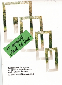
Pamphlet, A Special place to live, 1985 (addendum 1988)
A publication of the City of NunawadingA publication of the City of Nunawading explaining the regulations applying to the Special Residential (Nunawading) Zone No 5. The regulations cover proportions of land which may be built on and identifies trees which must be preserved. An addendum issued in 1988 includes a map of the area and identifies National Trust classified streets in Blackburn and the buffer areas in which less stringent regulations apply.A publication of the City of Nunawadingcity of nunawading, national trust of australia (victoria), special residential (nunawading) zone no. 5, jeffery street, blackburn, laurel grove, linum street, boongarry avenue, hill street, land use, by-laws, town planning, acacia avenue, waratah crescent -
 Whitehorse Historical Society Inc.
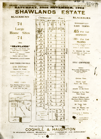
Document, Shawlands Estate, 22/11/1924 12:00:00 AM
Notice of Sale of land Holland Road and Canterbury RoadNotice of Sale of land Holland Road and Canterbury Road Blackburn Original in Haughton Maps LaTrobe LibraryNotice of Sale of land Holland Road and Canterbury Road land subdivision, canterbury road, blackburn south, holland road, shawlands avenue, coghill & haughton, shawlands estate, haughton map collection, state library of victoria. latrobe library -
 Whitehorse Historical Society Inc.
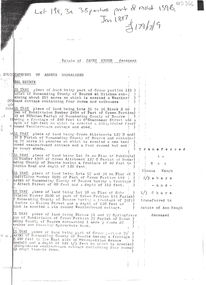
Document, Estate of James Keogh, 1897
Copy of the will of James KeoghCopy of the will of James Keogh, January 1897 involving land in Box Hill, Surrey Hills, Tunstall, Mitcham and Nunawading.Copy of the will of James Keoghkeogh, james, wills, thomas, ann, o'shannassey st, mitcham, mitcham road, albert street, haines street, springfield road, nunawading, springvale road, metropolitan avenue, watts street, box hill, victoria crescent, mont albert, whitehorse road, surrey hills, lightfoot street -
 Whitehorse Historical Society Inc.
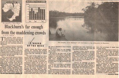
Article, Blackburn's far enough from the madding crowd, 25/08/1993 12:00:00 AM
Bell Bird area which is under the protection of the National Trust and the Blackburn Lake areaBell Bird area which is under the protection of the National Trust and the Blackburn Lake area are both select and sought after and houses bring high prices.Bell Bird area which is under the protection of the National Trust and the Blackburn Lake areacity of nunawading, national trust of australia (victoria), waratah crescent, blackburn, linum street, boongarry avenue, hill street, acacia avenue, jeffery street, myrtle grove, blackburn road -
 Whitehorse Historical Society Inc.
Document, Landscape Submission, c 1976
A landscape submission written for the National Trust of Australia (Victoria) for Blackburn Lake and the Bell Bird Streets.A landscape submission written for the National Trust of Australia (Victoria) for Blackburn Lake and the Bell Bird Streets. Definitions given of boundaries of the Lake area, ownership, housing and gardens. Photographs and map.A landscape submission written for the National Trust of Australia (Victoria) for Blackburn Lake and the Bell Bird Streets.blackburn lake sanctuary, waratah crescent, blackburn, jeffery street, hill street, boongarry avenue, linum street, laurel grove, acacia avenue, city of nunawading, melbourne and metropolitan board of works, furness park, camberwell grammar school -
 Whitehorse Historical Society Inc.
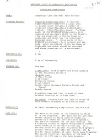
Poster - Postcards and handkerchief, c: 1919
Found in attic of Hardware store at No. 1 Barkly Avenue, Richmond. This store was the original home of the Turner Tools Company (later Stanley Tools Co). The Company moved to Swan Street Richmond before they moved to Nunawading. (Information Courtesy of Graham Plaw of the Hand Tools Preservation Society). Inscription from postcards written by Joseph Tracey to his wife Jessie and daughter Ruby, 9 Barclay Street, Richmond. Joseph's number was 2891, 38th battalion, 6th reinforcements. Joseph embarked from Melbourne Victoria on board HMAT A7 Medic on 16th December 1916 and returned to Australia 10 April 1919WWIWooden framed picture with eight souvenir postcards and one handkerchief from France 1919, mounted on wood veneer. Handkerchief with 1919 and pink flowers on top. Army photo of 17 soldiers. All postcards are embroidered and the handkerchief with lace edging a Souvenir de France: 1919.On the flower- Rose Day in London 13/7/17 Post card inscriptions: -Wednesday 11/4/17. Well Dear I did reseve your loving letter yesterday and I was pleas to heare that you was out of the Hospitle agan and I hope you keep well right now and Dear I hope you don't afto go in to the Hospitle agan Well Dear dont you voat for Conscription voat NO as the game is not fare. To My Loving Wife from your Loving Husbiun Lark Hill Camp -Just a small Card from a land so fare away amuce the snow and strangers in the lovey place they ? London I remain your loving husbuin Sutton Mandeville Camp To my Dear Wife From your lovening Husbuin Abroad -Just a small card from a Place far away and so cold and quite I wish I was near you agan and let it be sun I send this from Lark Hill Camp To My Dear Daughter From Dear Dader -To My Dear Little Ruby I am sending this card to you with my best love to you and lots of kiss for you Dear and hope you are a good Girl for Mother from your Dear Father in a place so far away. The best of love to you and hope you are well as it leave me in the best of Halth. Sent from Camp at Wind mill Hill on the Planys Vilies Tudgershall. Miss Ruby Tracey No. 9 Barkley Avenue E Richmond Melb Vic Australin -From Dear Dadey Just a token my Dear Daughter From your farther across the sea and smetimes I that I hear your laughter Blown right across the Water. From Sutton Mandeville No. 4 Trayind Camp To Miss R Tracey No 9 Barkley Avenue Richmond Australian -My Darling Wife Just a small card from your loving Boy and Hoping you Will be please with it I did get this at the camp we just came to the name of it is Sutton Mandeville and it was snowing a little. Mrs J Tracey No 9 Barkley Avenue Richmond Aust Vict Aust military history, army -
 Whitehorse Historical Society Inc.
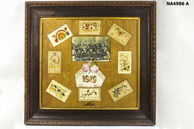
Photograph, Mrs. Slater
Mrs Slater and her husband William Slater migrated from Mitcham, Surrey, England in 1855 and established a herb farm in Nunawading - the first in Victoria. The farm was located in Blackburn Road, North Blackburn. When Mrs Slater died in 1895 the farm was sold. Slater Avenue and Slater Reserve is named for them.3 copies of Black and white photo of Mrs. Slaterslater, william, mrs, herb farms, slater avenue, blackburn north, slater reserve -
 Whitehorse Historical Society Inc.
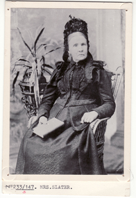
Photograph, William Slater
Mrs Slater and her husband William Slater migrated from Mitcham, Surrey, England in 1855 and established a herb farm in Nunawading - the first in Victoria. The farm was located in Blackburn Road, North Blackburn. When Mrs Slater died in 1895 the farm was sold. Slater Avenue and Slater Reserve is named for them.4 copies of black and white photo of William Slaterpioneers, slater, william, herb farms, slater avenue, blackburn north, slater reserve -
 Whitehorse Historical Society Inc.
Article, Boongarry Avenue, Blackburn, Autumn 2023
A photocopy of an article from a National Trust magazine pertaining to the landscape classification for Blackburn Lake and Bell Bird Streets.non-fictionA photocopy of an article from a National Trust magazine pertaining to the landscape classification for Blackburn Lake and Bell Bird Streets.boongarry avenue blackburn, blackburn lake, national trust of australia victoria -
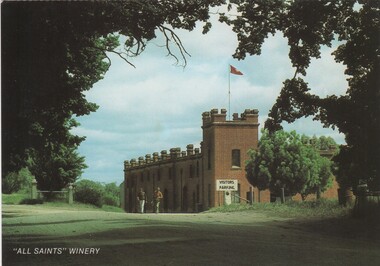 Rutherglen Historical Society
Post Card, Nucolorvue Productions Pty Ltd, 1970s
Colour postcard photograph winery resembling a castle with a square tower, viewed through an avenue of trees.At bottom left of photo: " 'All Saints' Winery" On back of card: "Rutherglen Victoria. Historic 'All Saints' Winery, of the 'Castle of Mey', Scotland, has a 'B' Classification from the National Trust of Victoria"all saints winery, castle of mey, wineries, wine industry -
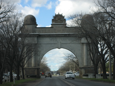 Ballarat Heritage Services
Photograph, Lisa Gervasoni, Ballarat Arch of Victory, 15/08/2007
Four views of the Ballarat Arch of Victoria, the entrance to the Ballarat Avenue of Honour.architecture, world war one, ballarat arch of victory, ballarat avenue of honour -
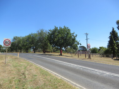 Ballarat Heritage Services
Photograph - Colour, Clare Gervasoni, Digby Avenue of Honour, Victoria, 22/12/2015
... Digby Avenue of Honour, Victoria.... Digby Avenue of Honour, Victoria Photograph - Colour Clare ...Colour photograph of the Avene of Honour in Digby, Victoria.digby, digby avenue of honour, world war one -
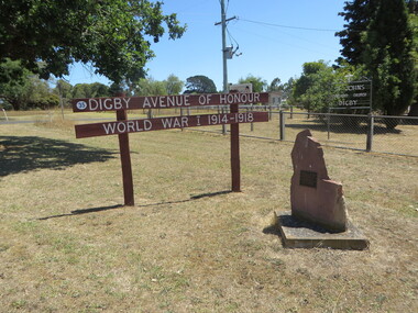 Ballarat Heritage Services
Photograph - Colour, Clare Gervasoni, Digby Avenue of Honour, Victoria, 22/12/2015
... Digby Avenue of Honour, Victoria... Office goldfields digby digby avenue of honour world war one ...Colour photograph of the Dignby Avenue of Honour.digby, digby avenue of honour, world war one -
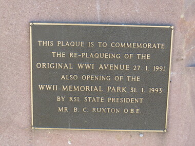 Ballarat Heritage Services
Photograph - Colour, Clare Gervasoni, Digby Avenue of Honour, Victoria, 22/12/2015
... Digby Avenue of Honour, Victoria... Digby Avenue of Honour, Victoria Photograph - Colour Clare ...digby, digby avenue of honour, world war one -
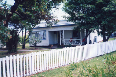
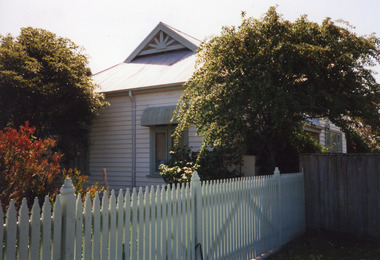 Lakes Entrance Regional Historical Society (operating as Lakes Entrance History Centre & Museum)
Photograph, 1999
This house was once the residence of Jules Lake, inaugural member of the Lakes Entrance RSL. A boat builder, he lost a leg on WW1 service.Colour photograph of timber house in Barkes Avenue. Corrugated iron roof, gablet ventilator on ridge. Window has metal window shade. White picket fence. Lakes Entrance Victoriahouses, heritage study -
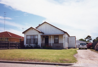
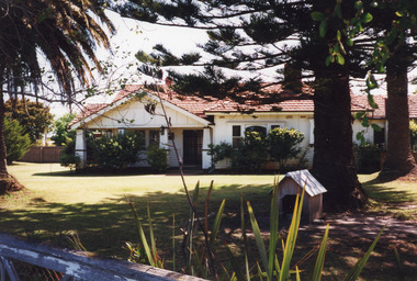 Lakes Entrance Regional Historical Society (operating as Lakes Entrance History Centre & Museum)
Photograph, 1999
Originally had corrugated iron roof, additions to house in 1950's, internal alterations, roof tiled.Colour photograph of a Californian Bungalow style dwelling at 15 Barkes Avenue. Outer walls of timber and cement render. Tiled roof has hips and valleys, gables above the veranda. Brick and concrete solid square veranda columns. Upper windows with leaded quarries. Lakes Entrance Victoriahouses, heritage study -
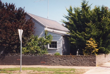
 Lakes Entrance Regional Historical Society (operating as Lakes Entrance History Centre & Museum)
Photograph, 2000
Some residents - Bill Giles, early 1920's, Mick and Doll Hobson, Colin and Ruby Watson, 1956's, Redenbach, Dan and Robyn Joiner, 1999.|Also one other colour photograph similar.Colour photograph of a timber dwelling a 6 Barkes Avenue. House has corrugated iron roof. Front veranda partially enclosed. Lakes Entrance Victoriahouses, fences, heritage study -
 Lakes Entrance Regional Historical Society (operating as Lakes Entrance History Centre & Museum)
Photograph, 2000
Some residents - Nurse Stewart, midwife, 1920's and 1930's, Christina Smith, dressmaker (daughter of Nurse Stewart), Con Coveoulos, Bill Barkas and family.Colour photograph of a weatherboard cottage, corrugated iron roof, front veranda partially enclosed at 16 Barkes Avenue. Brick fence a recent addition. Lakes Entrance Victoriahouses, heritage study -
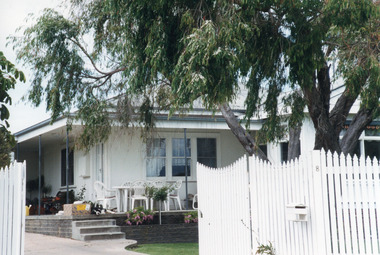 Lakes Entrance Regional Historical Society (operating as Lakes Entrance History Centre & Museum)
Photograph, 2000
... North Arm Avenue, Lakes Entrance Victoria... North Arm Avenue, Lakes Entrance Victoria Photograph ...Building was lounge and ballroom for Robin Hood Inn, a popular guest house situated on corner of Esplanade and Carstairs Avenue. It was broken up, and components relocated, to make way for Sherwood Lodge Motel in 1958.Colour photograph of a fibro dwelling, hipped roof with gable extension, veranda over main room with triple sash window and French door. White timber picket fence and gate, situated at 8 North Arm Avenue, Lakes Entrance Victoriahouses, heritage study -
 Lakes Entrance Regional Historical Society (operating as Lakes Entrance History Centre & Museum)
Photograph, 2000
House built on Rogby Island by Mitchelson around 1915, relocated to corner of Lake Street and Barkes Avenue around 1920, then to Phillips Street 1962. Front window altered, veranda frieze removed, side extension of veranda removed.Colour photograph of a timber residence at 3 Phillips Street. Gable roof, fibro cement section under gables. Front door has fanlight above, widow light beside door filled in. Barge board of gables typical of dwellings built by Leo Mitchelson, Lakes Entrance Victoriahouses, heritage study -
 Lakes Entrance Regional Historical Society (operating as Lakes Entrance History Centre & Museum)
Photograph, 1999
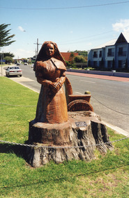
Carved by chainsaw artist John Brady August 1998.Colour photograph of the most westerly chain saw carving made from trunk of WW1 Memorial avenue cypresses. On lawn verge, south of Princes Highway, opposite Bellevue, Lakes Entrance Victoriaworld war 1914-1918, memorials -
 Lakes Entrance Regional Historical Society (operating as Lakes Entrance History Centre & Museum)
Photograph, 1999c
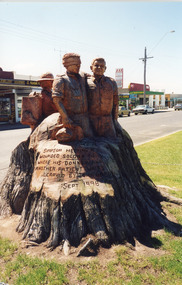
Carved by chainsaw artist John Brady, September 1998.Colour photograph of the most eastly of the three sculputres carved from WWI Memorial Avenue adjustant to the western Hharbour Esplande Lakes Entrance Victoriaworld war 1914-1918, memorials -
 Lakes Entrance Regional Historical Society (operating as Lakes Entrance History Centre & Museum)
Photograph, 1999c
Colour photograph of sculptures carved from WW1 Memorial Avenue cypress trees, Lakes Entrance Victoriaworld war 1914-1918, memorials -
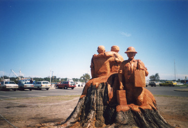
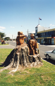 Lakes Entrance Regional Historical Society (operating as Lakes Entrance History Centre & Museum)
Photograph, 1999c
Colour photograph of sculptures carved from WW1 Memorial Avenue cypress trees, Lakes Entrance Victoriaworld war 1914-1918, memorials