Showing 10063 items
matching floods-orbost-1971
-
 Lakes Entrance Historical Society
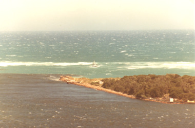
Photograph, Jack Donelly, floods 1998 Lakes Entrance Victoria, 1998 c
... floods 1998 Lakes Entrance Victoria...Floods ...Photograph taken from Jemmys PointColour photograph showing discoloured flood water backed up by the incoming tide with fishing boat Crianda shown approaching the Western Pier at the entrance Lakes Entrance Victoriafloods, accommodation -
 Orbost & District Historical Society
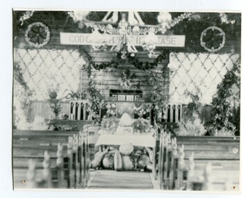
black and white photograph, C1900
The first Orbost Presbyterian Church was opened on January 9 1898. It was built by Mr R. P. Cameron for three pounds. The Harvest Festival display was always put together by the church ladies. The Festival was a family friendly festival celebrating the end of summer.This item is reminiscent of the late 19th - mid 20th centuries when church-going was more common.A black / white photograph of inside the Orbost Presbyterian Church decorated with rural produce and flowers for the "Harvest Festival". It is on a white buff card with a blue photographer's stamp in the bottom left hand corner.on front - stamp -" Herbert Sherwood" on back - "M. Gilbert, Orbost" - "Mrs J. Sterling, 6 Marine Parade , Elwood"church-presbyterian-orbost harvest-festival -
 Deaf Children Australia
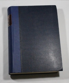
Book, Minutes Oct 1969 to Dec 1971
The minutes of each meeting of the Board of Management of the Victorian Deaf & Dumb Institution, the Victorian School for Deaf Children and Deaf Children Australia has been retained from 1862 to 2010.The minutes of the meetings provide an insight into the day to day running of the School, from Wages and Salaries, student issues to broader educational topics, building works and finances.Blue leather(?) bound book containing typed copies glued onto white pages containing minutes of meetings of the Board of Management of the Victorian School for Dear Children from October 1969 to December 1971Spine: "MINUTES/Oct 1969 to Dec 1971" in gold lettering on a dark red backgrounddeaf children australia, deaf education, minutes of meeting -
 Tatura Irrigation & Wartime Camps Museum
Photograph, 1955 Tatura Floods, 2001
... 1955 Tatura Floods ...In 1955 Ross Street North had to be cut to allow flood waters to relieve the flooding of the Tatura Township. The Midland Highway west of the Tatura Undera Road was cut by flood waters.floods 1955, ross st, midland highway, hogan's farm, baldwin road, photograph, people -
 Orbost & District Historical Society
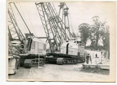
black and white photographs, 1974 - 1976
Construction of the roadway embankment between the bridges across the Snowy River flood plains at Orbost commenced in January 1974 and was completed in November 1976. Pearsons were the bridge contractors for the construction of the Princes Freeway and bridges across the river flood plains at Orbost. Heavy rains and floods held up progress.These photographs are of the construction of a major structure in Orbost. The opening of this Snowy River Bridge was an important development in the accessibility to the township of Orbost.Four black / white photographs of construction sites. 3241.1 is of three cranes and other machinery with six persons. 3241.2 is of workmen working on flooded site. 3241.3 is a photograph of the early stages of construction of a bridge looking towards the township. 3241.4 shows the construction of a roadway between the bridges.construction-snowy-river-bridge bridge-orbost -
 Orbost & District Historical Society
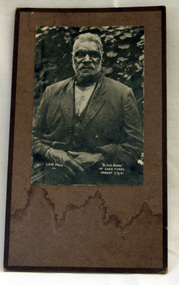
black and white photograph, "Black Andy of lake Tyers ORBOST 1/3/21", 1. 2.1921
In 1861 the Lake Tyers Mission Station was established by the Church of England missionary Reverend John Bulmer, to house some of the Gunaikurnai survivors of the conflict. The peninsula, which has a lake on each side, was known to its traditional owners as Bung Yarnda.A black and white photograph of an older, bearded Aboriginal man. He is sitting outdoors in front of a leafy bush. He is wearing a suit.Black Andy of Lake Tyers ORBOST 1/3/21 L.G.W. photo 741lake-tyers photograph -
 Orbost & District Historical Society
photograph, first half of 20th century prior to 1976
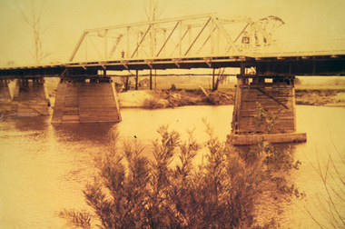
Purchased from Orbost Op shop several years ago. Original owner unknown. This bridge over the Snowy River was opened on July 4 1922. It was constructed in 1922 alongside the previous suspension bridge. Its building was a combined effort of the Victorian Railways and the Country Roads Board at a cost of 35,000 pounds. It was replaced in 1976 by the present bridge after several major floods.This bridge was replaced in 1976 after several major floods.A wooden framed photograph of the second Snowy River bridge at Orbost.photograph snowy-river-bridge -
Lakes Entrance Historical Society
Book, LERHS, Railway Bairnsdale to Orbost, VTF Project, 2015
Information on the construction of the railway from Bairnsdale to Orbost, the stony creek, trestle bridge also plans for the very fast train from Melbourne to Sydney Lakes Entrance Victoriatransport, bridges -
 Eltham District Historical Society Inc
Photograph, Eltham - Floods in 1934
... Eltham - Floods in 1934...floods ...To the left of picture is the Main Road Bridge over the Diamond Creek in Eltham South when the Diamond Creek was in flood. The Yarra also was in flood. In early December 1934 the "Greatest flood in the history of the Yarra" occured, according to The Argus newspaper. Bridges and houses were swept away with hundreds of people left homeless across the state. The historic 1934 flood of the Diamond Creek and Yarra River set the criteria for future planning with respect to flood water rise.This photo forms part of a collection of photographs gathered by the Shire of Eltham for their centenary project book, "Pioneers and Painters: 100 years of the Shire of Eltham" by Alan Marshall (1971). The collection of over 500 images is held in partnership between Eltham District Historical Society and Yarra Plenty Regional Library (Eltham Library) and is now formally known as 'The Shire of Eltham Pioneers Photograph Collection.' It is significant in being the first community sourced collection representing the places and people of the Shire's first one hundred years.Digital image 4 x 5 inch B&W Negsepp, shire of eltham pioneers photograph collection, eltham, diamond creek (river), 1934 flood, diamond creek, floods, main road bridge -
Lakes Entrance Historical Society
Book, Orbost Historical Society, Curlip Journal, 2005
A Journal presenting history of the Orbost district produced from information gathered during a historical bus trip taken by thirty local residents to Bete Bolong Newmerella Corringle and Lochend Orbost Victoria -
 Orbost & District Historical Society
magazines, Croajingolong Document of a Decade, 1970
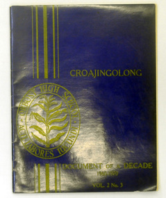
This is a special issue of the annual Orbost High School magazine. It revisits the decade 1960-1970. The name Croajingolong derives from the Australian Aboriginal Krauatungalung words galung, meaning "belonging to" and kraua, meaning "east". 2218.1 belonged to Mary Gilbert, a former teacher at the school.This magazine is a useful reference tool.Two copies of a magazine with a dark blue cover. It is titled Croajingolong Document of a Decade. On the front cover the print 1960-1970 Vol.2 No. 3 is in yellow/gold and the Orbost High School crest is on the left hand side in yellow. 2218.2 has autographs inside the covers. 2218.1 has the Orbost Historical Society stamp on the inside back cover.croajingolong orbost-high-school -
 Orbost & District Historical Society
black and white photograph, Campbell. D.S, late 19th century ?
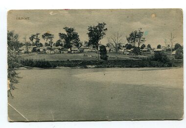
This is a photograph of the settlement of Orbost on the banks of the Snowy River,. In the foreground in the paddock there is a water trough (Bills?) and the B Drain can be seen on the far left. D.S. Campbell had a stationery store in Nicholson Street Orbost and published several black and white postcards of Orbost.This is a pictorial record o The township of Orbost in the late 19th century.A black / white photograph / postcard. There is a river in the foreground with houses and shops in the background behind a cleared paddock.on front - Orbostorbost-19th-century snowy-river -
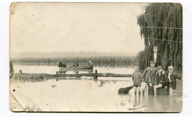 Orbost & District Historical Society
black and white photograph, 1934
This photograph was taken during the flood of 1934 in Orbost. The people in the photograph are related to Billie and Ilma Nixon and Charlie Johnston. Damage estimated at £500,000 was caused by the 1934 floods in the Orbost district. This 1934 flood was devastating, destroying a section of the 1922 Orbost bridge, wrecking fences, bridges and roads, dumping silt and debris on the rich river flats and drowning cattle.This item is a pictorial record of a significant event in Orbost's history. It is associated with local families.A black / white photograph / postcard of floodwaters. On the right is a young man with four young boys sitting on a log. In the bckground is a rowing boat with one man rowing and three others sitting on the edges . A field of maize / corn is in the background and a large willow tree on the right.on back - "M. C. Rice Orbost 19 /1/20 M Gilbert. Mostly Billy Nixons & Charlie Johnstons 1934" [Note alteration: W C Rice rather than M C Rice].floods-orbost-1934 nixon-william johnston-charles -
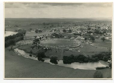 Orbost & District Historical Society
black and white photographs, March 10 1961
These photographs are pictorial record of Orbost in 1961.They enable us o observe the objects in their spatial context and in detail. They are useful for reference.Four black / white aerial photographs. there are spare copies of each. 3276.1 is an aerial photograph of the Orbost Show with Lochiel Park in the foreground. 3276.2 is an aerial photograph taken over a township. 3276.3 shows the Orbost High School on the left. 3276,4 shows the high school in the foreground.on the back of each is "March 10th 1961 Aerial of Orbost"photographs-aerial-orbost-1961 orbost-1961 lochiel-park -
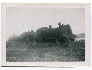 Orbost & District Historical Society
black and white photographs, 1950s
Dudley Charles Seymour Courtney , with a fellow worker, was trapped on the Orbost Raailwaay Station roof until rescued by an army duck. These photographs were his. He worked on the railway in Orbost from 1942 - 1952 approximately. During the 1952 flood nearly half of Orbost rail way station is washed away. The stationmaster and four members of his staff were rescued by police using army ducks.This is a pictorial record of a significant event in the history of Orbost.Nine small black / white photographs of a derailed train at a railway station. Derailed trucks and floodwaters can be seen. The photographs have a narrow white frame. Some are portrait and others landscape.on back of 3082.8 - hand-written in blue pen :"The floods worked the line from under the trucks in a couple of hours"floods-orbost orbost-railway-station rescue courtney-dudley-charles-seymour -
 Orbost & District Historical Society
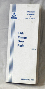
program, 1971
This program was made for the Orbost Apex Club to be used on the "change over night" of August 6th 1971. Apex Clubs were begun in March 1931 when three young architects, looking to make a contribution to their local community of Geelong Victoria, decided to create Apex. Apex is a volunteer community service organisation whose members work in local clubs across urban, regional and rural Australia to raise awareness about social justice issues, assist the needy in a practical way and contribute resources to worthwhile causes. (ref Apex website)The Apex Club of Orbost was a volunteer service club which contributed to the Orbost community. A declining population has led to the demise of many social groups in the area.A white triple fold cardboard program. It has blue print on the white background.APEX CLUB OF ORBOST 13th Change Over Nightprogram apex service-club -
 Kew Historical Society Inc
Photograph - River Yarra in Flood from Kilby Road
Flooding of the Yarra Valley, including that section of the Yarra bordering Kew and Kew East in the north and west of the municipality, was a regular occurrence. Extreme flood events of the Yarra River are recorded to have occurred in 1891, 1901, 1916, 1923 and 1934. The Municipality of Kew's response to these floods was to enact planning decisions restricting residential development in flood prone areas following the floods of 1916, 1921 and 1934. While floods continued after the development of the Upper Yarra Reservoir (construction 1948-57), the regularity and extent of these inundations diminished.Print copy of an original photo of the River Yarra in Flood, taken from Kilby Road.VIEW ACROSS YARRA IN FLOOD / FROM KILBY RD KEWkilby road, floods -- kew (vic.), kilby farm -
Ringwood and District Historical Society
Minute Book, Education Department Victoria, Ringwood State School Finance Committee Minutes Book 1964-1971, Jul-1964 to May-1971
Minutes of meetings held by the Finance Committee of the Ringwood State School from Jul-1964 to May-1971. Note in front cover 'Earlier minute books handed to Head Teacher, Ringwood State School 2997 on 25th March, 1968 for safe keeping' Signed Horn.Minutes of meetings held by the Finance Committee of the Ringwood State School from July 1964 to May 1971. Pale blue cardboard covers, cream cloth spine. Half pages unused. Sticky tape used on front edge of spine.Minute Book, Education Department, Victoria. -
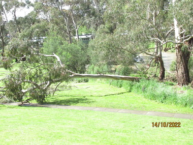 Greensborough Historical Society
Photograph - Photograph - Digital Image, Peter Simmenauer, Plenty River floods near Plenty Lane 2022, 14/10/2022
... Plenty River floods near Plenty Lane 2022...floods ...Plenty River in flood near Plenty Lane Greensborough, October 2022. Colour digital photographDate stamped: 14/10/2022plenty lane greensborough, plenty river, floods -
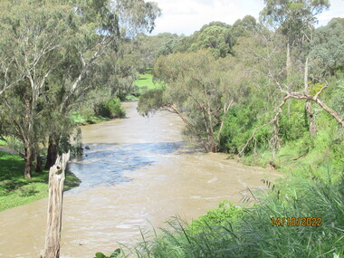 Greensborough Historical Society
Photograph - Photograph - Digital Image, Peter Simmenauer, Plenty River floods near Plenty Lane 2022, 14/10/2022
... Plenty River floods near Plenty Lane 2022...floods ...Plenty River in flood near Plenty Lane October 2022 Greensborough. Colour digital photographDate stamped: 14/10/2022plenty lane greensborough, plenty river, floods -
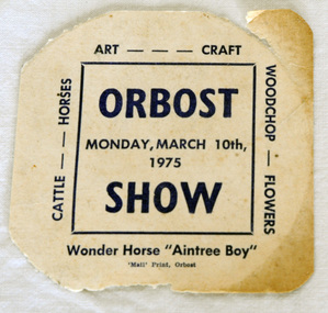 Orbost & District Historical Society
ticket, 1975
Owen 'Doc' Matthews is remembered for his spectacular Grand Prix dressage exhibitions with his horse Aintree Boy, performed to music under spotlights at Melbourne Royal Show from 1965-1975. He also performed at smaller country shows. Doc Matthews was born in the Melbourne suburb of Fitzroy in 1923, during the Great Depression. He and his brother Paddy were placed in a foster home and then in a Geelong orphanage before being put to work at a dairy farm. Doc was given an elderly piebald mare to ride, which ignited his passion for horses. When he was 16, he enlisted in World War 2 but captured by the Japanese and ended up working on the Burma Railway, spending years as a prisoner of war in the notorious Changi Prison. Doc joined Victoria Police in 1952 and by 1962 was chief horse master and riding instructor in the mounted branch. He drilled teams to perform musical rides and horses and riders were always turned out to perfection. Doc and Aintree Boy became a partnership after the horse had been used in the mounted branch for four years. Doc decided to try his hand at dressage and as there were few instructors, trained Aintree Boy with nothing to go by but a couple of books and film of a single dressage competition. Owen 'Doc' Matthews was truly a pioneer of Grand Prix dressage in Australia. ( ref. TOPHORSE )Agricultural shows are an important part of cultural life in small country towns and the Orbost Show is an integral part of Orbost 's agricultural history.A square shaped ticket for Orbost Show - Monday, March 10th 1975. It is on white card with blue print.Orbost Wonder Horse "Aintree Boy". Monday, March 10th 1975aintree-boy dressage equestrian matthews-owen -
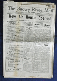 Orbost & District Historical Society
newspaper, Snowy River Mail, 29.3.1950
The Snowy River Mail is a weekly newspaper published in Orbost in the Shire of East Gippsland, Victoria, Australia. Previously published as The Snowy River mail and Tambo and Croajingolong gazette from 1890 to 1911. The Gippsland Courier merged with the Snowy River Mail when proprietor Lachlan Ross moved to Orbost in 1910. In 1999 the paper was acquired by the Yeates family when the Hollins family retired from the newspapers business. The paper is still being produced by the fourth generation of the Yeates family as part of East Gippsland Newspapers. The 1950 flood was a significant event in Orbost. This newspaper is a contemporary record of a significant local events.A Snowy River Mail newspaper dated 29.3.1950. It contains news articles and advertisements in black/white print. it contains an article on the flood at that time.snowy-river-mail 1950-flood newspaper -
 Kew Historical Society Inc
Photograph - Yarra Valley Floods: Kew East, 1916
Flooding of the Yarra Valley, including that section of the Yarra bordering Kew and Kew East in the north and west of the municipality, was a regular occurrence. Extreme flood events of the Yarra River are recorded to have occurred in 1891, 1901, 1916, 1923 and 1934. The Municipality of Kew's response to these floods was to enact planning decisions restricting residential development in flood prone areas following the floods of 1916, 1921 and 1934. While floods continued after the development of the Upper Yarra Reservoir (construction 1948-57), the regularity and extent of these inundations diminished. During the nineteenth century, the land abutting the south side of the Yarra in Kew was devoted to dairy farming. In the twentieth century, before and after the construction of the Eastern Freeway, much of this low-lying area was used as golf courses and public parks.One of a collection of photographs of flooding in the Kew section of the Yarra Valley which are in important research resource for the location and extent of flooding in the first half of the twentieth century. Flooding of the Yarra Valley at East Kew in 1916. The view is taken from a street (maybe Birdwood Avenue) intersecting with Kilby Road looking northeast across the flood waters to Ivanhoe and Heidelberg. The extensive flooded area shown in the photograph would have included remnant dairy farms and the Kew Golf Club. Verso: "Floods / Yarra River / East Kew / Kilby Road / 1917? / 87"yarra river, yarra valley, floods -- kew, kilby road -- kew (vic.), kew golf club -
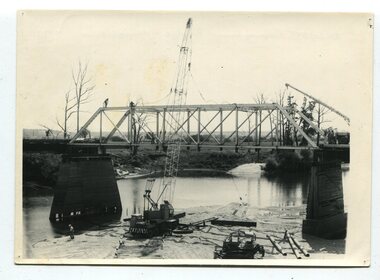 Orbost & District Historical Society
black and white photographs, 1977
This is a series of photographs of the demolition of the 1922 bridge across the Snowy River at Orbost. This bridge over the Snowy River was opened on July 4 1922. It was constructed in 1922 alongside the previous suspension bridge. Its building was a combined effort of the Victorian Railways and the Country Roads Board at a cost of 35,000 pounds. It was replaced in 1976 by the present bridge after several major floods.This bridge was replaced in 1976 after several major floods. These photographs record the demolition of that bridge.Ten black / white photographs of a road bridge demolition. In the photographs are cranes, one on a barge, and workmenon back - Orbost Snowy River Bridge demolition 1977 -
 Kew Historical Society Inc
Photograph - Yarra Valley Floods: Kew East, 1916
Flooding of the Yarra Valley, including that section of the Yarra bordering Kew and Kew East in the north and west of the municipality, was a regular occurrence. Extreme flood events of the Yarra River are recorded to have occurred in 1891, 1901, 1916, 1923 and 1934. The Municipality of Kew's response to these floods was to enact planning decisions restricting residential development in flood prone areas following the floods of 1916, 1921 and 1934. While floods continued after the development of the Upper Yarra Reservoir (construction 1948-57), the regularity and extent of these inundations diminished. During the nineteenth century, the land abutting the south side of the Yarra in Kew was devoted to dairy farming. In the twentieth century, before and after the construction of the Eastern Freeway, much of this low-lying area was used as golf courses and public parks.One of a collection of photographs of flooding in the Kew section of the Yarra Valley which are in important research resource for the location and extent of flooding in the first half of the twentieth century. Flooding of the Yarra Valley at East Kew in 1916. The view is taken from the intersection of Kilby Road with what is believed to be Birdwood Street, looking across the flood waters to Ivanhoe. The extensive flooded area shown in the photograph would have included the Kew Golf Club. Verso: "Floods along Kilby Road / near Birdwood St? & Kilby Road / 1917? / 87yarra river, yarra valley, floods -- kew, kilby road -- kew (vic.), kew golf club -
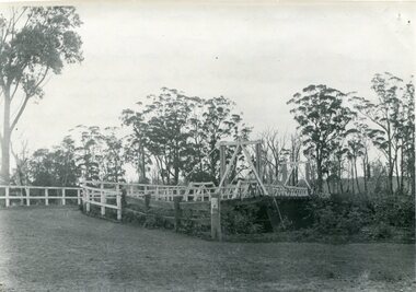 Orbost & District Historical Society
black and white photograph, August 1897
This is a photograph of the bridge from the Orbost side. The first pile bridge over the Snowy River was just completed by Mr Jim Granter when the 1891 flood took out the centre,. There were differences of opinion as to whether the council should pay . The Shire Secretary, Mr John Draffin, persuaded them to honour their obligations. Mr Granter and Mr Clarke finished it as a suspension bridge which was opened by Mrs William Watt. Soon after a mob of cattle stampeded, the weight snapped the cable, letting one side sag. Mr R.P. Cameron repaired it and this bridge remained until 1922. "In 1890 the contract for a bridge was let to Mr James Granter for £1450. This structure with additions and improvements made to it was to cost the ratepayers about £2,500, and its erection was proceeded with in a very satisfactory manner until, just as the greater-part of the work had been completed, the flood of 1891 came down on it, piling up mountains of logs, timber and debris against the piers, which had not been made wide enough apart to allow for. contingencies of this kind. The structure held out bravely until the turn of the flood and then gave way with a crash, about five bays from the centre disappearing in the stream." ( Snowy River Mail August 12 1893) This item is a pictorial record of one of the first bridges across the Snowy River in Orbost.A black / white photograph of the old wooden suspension bridge over the Snowy River. There are two copies 919.1 and 919.2. There are two other photos showing the whole bridge taken from further back.on back - "Orbost Bridge...."snowy-river-bridge-orbost granter-james -
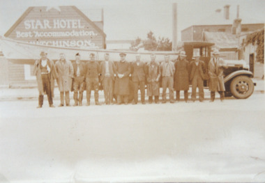 Lakes Entrance Historical Society
Photograph, H D Bulmer, Lakes Entrance fisherman rescue during 1934 floods near Sale, 1934 c
... Lakes Entrance fisherman rescue during 1934 floods near...Floods ...Lakes Entrance fishermen travelled to the Sale area to assist in the rescue of flood victims during 1930sSepia toned photograph of Lakes Entrance fishermen standing beside a boat on the tray of a small truck outside the Star Hotel Sale Victoriaships and shipping, floods, natural disasters -
 Kew Historical Society Inc
Photograph - Flood at Fairfield Park, 1934
Flooding of the Yarra Valley, including that section of the Yarra bordering Kew and Kew East in the north and west of the municipality, was a regular occurrence. Extreme flood events of the Yarra River are recorded to have occurred in 1891, 1901, 1916, 1923 and 1934. The Municipality of Kew's response to these floods was to enact planning decisions restricting residential development in flood prone areas following the floods of 1916, 1921 and 1934. While floods continued after the development of the Upper Yarra Reservoir (construction 1948-57), the regularity and extent of these inundations diminished.Black and white print positive. Yarra River at Fairfield in 1934. Major flood resulting in submerged buildings in middle ground and onlookers on far bankReverse: "Flood of Yarra at Fairfield Park 1934"fairfield park, yarra valley, river yarra, floods -- 1934 -
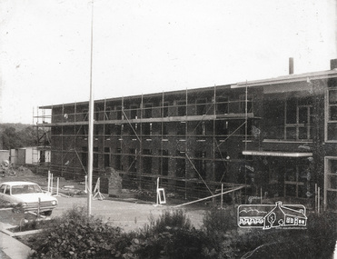 Eltham District Historical Society Inc
Photograph, Completing the south wing of Eltham Shire Offices for Library and Planning Departments, 1971, 1971
Completing the south wing of Eltham Shire Offices for Library and Planning Departments, Main road, Eltham. Building demolished 1990s.1 photographBack: "Shire Office extensions 1971" eltham, shire of eltham, eltham library, building, planning department -
Vision Australia
Text, Newspaper clippings 19 (1967-1971), 1967-1971
News stories from fundraising events including The Guiding Light Appeal. 1 folder with newspaper cuttingsVarious articles from 1967 - 1971association for the blind