Showing 1588 items
matching james hill
-
 Phillip Island and District Historical Society Inc.
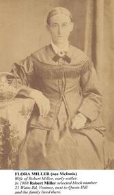
Photographs, Flora Miller & Catherine Walker (nee Miller), approx 1880's
The Millers & Walkers Phillip IslandTwo Photographs on backing sheet. 403-01: Flora Miller 403-02: Catherine Walker and family403-01: "Flora Miller (nee McInnis) Wife of Robert Miller, early settler. In 1868 Robert Miller selected block No. 21 Watts Road, Ventnor, next to Quoin Hill and the family lived there. 403-02: "Catherine Walker (nee Kitty Miller) Photographed with three of her children around 1888. (The identity of the man and the youngest child in this photograph are unknown. Records show that Catherine's husband, James Walker, died in 1885. Her youngest child was her daughter, Flora, on left in the photo).flora miller (nee mcinnis), catherine walker (nee kitty miller), james walker, robert miller, lynette carr -
 Phillip Island and District Historical Society Inc.
Photograph Album, Kodak, Phillip Island Cemetery, c 1990
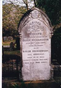
The Album was compiled by Nancy McHaffie late 1990's, with the assistance of Edith Jeffery's, with her book "Garden of Memories" and extensive knowledge of Phillip Island. The Cemetery lies back from the road and is surrounded by Manna Gums, rare Peppermint Gums, Blackwoods and other native trees. In all 25 acres of land were set aside as Crown Land in the land settlement of 1868. There are 6.2 acres of wetlands near the cemetery entrance.466-23: Joseph Richardson came to Australia in 1837 from Liverpool, England. Sarah Arbuckle and her two sisters arrived in 1850. Sarah and Joseph were married when gold was discovered in Victoria. They went to the diggings and had some success. Joseph bought land on Phillip Island when it was open to freehold selection in 1868. The family moved to Phillip Island shortly afterwards, to a house they built on a hill west of Cowes. They called their home "Everton" after a Liverpool suburb. The house still stands in Church Street, known as "Tallawalla". 466-24: The McIlwraith family came from Melton, Victoria to Heath Hill, Rhyll in 1869. They played an important part in the early history of Phillip Island. James was a foundation member of the Trust, John and Alan played their part in the local scene. John was President and Alan Secretary of the Cemetery Trust for many years.phillip island cemetery, nancy mchaffie, edith jeffery -
 Phillip Island and District Historical Society Inc.
Book, Western Port ferries past and present and Captain Clarke, their most notable skipper, 1973
james leathen clarke, coastwise shipping, victoria, western port, ferries, transport, biographies -
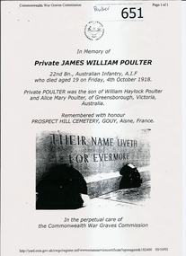
![Photograph - Digital image, James William Poulter [as soldier], 1916_](/media/collectors/4f729f5697f83e03086015b8/items/54cb4a862162f116e05fe692/item-media/54cb4aad2162f116e05fe8a2/item-fit-380x285.jpg) Greensborough Historical Society
Greensborough Historical SocietyPhotograph - Digital image, James William Poulter [as soldier], 1916_
Studio portrait of 5078 Private (Pte) James William Poulter, 22nd Battalion. A driver from Greensborough, Vic prior to enlistment, Pte Poulter embarked with the 13th Reinforcements from Melbourne on HMAT Ayrshire on 3 July 1916. After being twice wounded in action, he was killed in action on 4 October 1918, aged 19 and was buried in the Prospect Hill Cemetery, Gouy, FranceGreensborough pioneer familyDigital copy of black and white studio photograph.james william poulter -
 Greensborough Historical Society
Letter, Letter re Private James William Poulter, 16/04/1920
Copy of Commonwealth War Graves Commission information regarding the burial place of Private James William Poulter (died 1918, buried at Prospect Hill Cemetery; Gouy; Aisne; France) and copy of a letter from his mother giving details of her knowledge of the burial.Information about the Poulter family, Greensborough pioneers.2 pages. Copy of Commonwealth War Graves Commission information regarding the burial place of Private James William Poulter and copy of a letter from his mother.james william poulter, poulter, greensborough, war graves -
 Greensborough Historical Society
Photograph - Digital Image, Blackjack - looking south east up the hill, 1954_
Greensborough wattles at Blackjack. The Blackjack property, house and acres of fruit orchards ran down to the Plenty River off Hume Street Greensborough and was the home of the Robinson family to late 1956. The photographs were taken as slides by Frank Robinson and digitised by his son James in 2015.Digital copy of colour photograph.robinson family, blackjack -
 Greensborough Historical Society
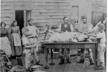
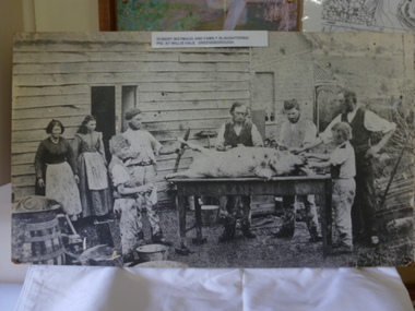
Photograph - Digital Image, Willis Vale - Whatmoughs butcher a pig, 1870c
Robert Whatmough and family lived at Willis Vale from approx 1863 to 1878. Willis Vale was later owned by the Partington family. In this photograph the family is involved in butchering a pig. The people have been identified as: Mary (Hill) Whatmough b1813; and her daughter Rosalie b1856; Grandpa John Wilson; Joseph Wilson b1835; Emmett Whatmough b1842; John Thomas Fielding b1860; James Fielding b1861; Robert Whatmough b1815; [Sarah Whatmough b1845 m1866 Joe Wilson b1835 8 children].A pioneer Greensborough family.Digital copy of black and white photograph.willis vale, robert whatmough -
 Greensborough Historical Society
Photograph, Robert Whatmough and family slaughtering pig at Willis Vale Greensborough. 1870, 1870_
Robert Whatmough and family lived at Willis Vale from approx 1863 to 1878. Willis Vale was later owned by the Partington family. In this photograph the family is involved in butchering a pig. The people have been identified as: Mary (Hill) Whatmough b1813; and her daughter Rosalie b1856; Grandpa John Wilson; Joseph Wilson b1835; Emmett Whatmough b1842; John Thomas Fielding b1860; James Fielding b1861; Robert Whatmough b1815; [Sarah Whatmough b1845 m1866 Joe Wilson b1835 8 children]. Photo and article also appeared in The Diamond Valley News 9/10/1984 page 26.Early evidence of farming and animal husbandry in the Greensborough area.Black and white photograph, enlarged and mounted on timber backing.Typed caption pasted on front of photograph: 'Robert Watmaug [sic Whatmough] and family slaughtering pig at Willis Vale Greensborough.' Identification of those in photo by Faye Fort 2015.robert whatmough, whatmough, willis vale, greensborough, wilson -
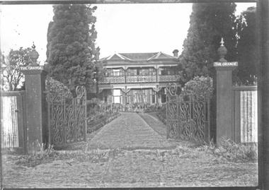 City of Moorabbin Historical Society (Operating the Box Cottage Museum)
Photograph - 3 black & white Photographs, 'The Grange' ( 'Baydon Hill' ) Moorabbin, c 1920
'The Grange ' was a 2 storey home built 1857 by Mr Charles Tuck, originally named 'Baydon Hill' , at 1011 Nepean Highway, Moorabbin ( South Brighton). Mr Charles Tuck was Veterinary Surgeon from Baydon Hill, Wiltshire, England, who migrated to Australia c1850. He married his cousin Miss Jan Chaudler in Melbourne in1853. He was at the Ballarat gold-fields at the time of the riots and then they settled in South Brighton ( later Moorabbin) and built a large Georgian Styled home called 'Baydon Hill'. The Tucks had a large family - 9 children. Charles enjoyed a prosperous Veterinary Practice as his advice was needed for stock purchases by the farmers / settlers. Charles died in 1893 and Jane left the property c 1903 and died at Blackburn in 1928. The House had 5 owners, the last being the Healey family c1920 and at some stage the name was changed to 'The Grange' and the gates shown were installed. The Healey Family were also prosperous in developing vegetables and flower seeds and seedlings. 'The Grange' was sold to Moorabbin City Council 1972 and then used by the City of Moorabbin Historical Society for meetings and storage of historical material. It was demolished amidst considerable controversy 1983 and the District Police Offices were built on the site. ( S.T.Mulvany, Grand-daughter of Charles Tuck 26/7/1974)The Grange was a significant property 1853 -1983 in Moorabbin. It was built by Mr Charles Tuck 1857and in1900 extended from Point Nepean Road to South Road - 10acres. Mr Harold James Healey purchased the property in c1920 and leased a portion to a Chinese market gardener. Later with his sons he established a profitable Plant Nursery that they managed for 42years.. Keith Healey, a son, remodelled the house extensively mid 20thC .The Moorabbin City Council purchased it in 1972 for $255,000 and it was demolished amid controversy 1983. The District Police Offices are now on the site.3x black and white photographs of the property at 1011 Nepean Highway Moorabbin built by Mr Charles Tuck c1853 known as 'The Grange'. Originally it was named 'Baydon Hill' because he migrated from Baydon Hill, Wiltshire, England c1850. These photographs are c 1880, 1920 and 1950 showing the original and later additions made to the property by some of the 5 owners.Written in pencil on back a) " This Photo donated by Mr Neil Follett - at the time it came into his possession he had a photography studio in Cheltenham. Photographer unknown"; Folio 6 b) The Grange c 1950 Folio 6/10 c) 'Baydon Hill' ( alias "The Grange" ) / Donated by Mrs Elsa Jones, daughter of Leslie Stephen Tuck, youngest son of Charles Tuck Folio 6 /18tuck charles, tuck jane, veterinary surgeons, livestock, market gardeners, early settlers, dendy's special survey, brighton, moorabbin, ballarat, gold diggings, horses, chickens, cattle, bullocks, flower shows, fruit garden, mulvaney s. t., healey haold james, healey keith, moorabbin city council, chinese market gardeners, plant nursery, tuck leslie stephen, jones elsa -
Glenelg Shire Council Cultural Collection
Photograph - Sheet of 12 contact prints - Various historic Portland buildings and Landmarks, c. 1970
Sheet of 12 contact prints of rephotographed photographs. Identification numbers 5719 a, b, c, d, e, f, g, h, i, j, k, l (a) Portland Tennis Club (b) Portland Show (c) Court House (d) Row of single storey wooden buildings on beach, Lighthouse of Observatory Hill back left (e) Fishing party Bridgewater (f) Dray loaded with bales outside Grant & Co Merchants (g) Image of Capt. James Fawthrop (h) Residence Abraham Barrett, baker (i) Group of 6 in tennis clothes late 1900's - early 1900's style (j) Portland Tennis Club (k) Tasmanian Inn (l) Windsor CottageFront: (a) Working-Bee, Portland Tennis Club approx 1900 (b) Portland Show (c) Court House (e) Angling Party, Bridgewater approx 1900 (g) Capt. Fawthrop -
 Halls Gap & Grampians Historical Society
Postcard - B/W, C 1890-1920
This is a Rose's Australia stereocard of Morningside. Built c1875, Morningside was the residence of John and Catherine D'Alton, it was located on site of present (2010) Colonial Motor Inn. c1900 it was owned by Langley family and was taking in paying guests. In 1909 it was leased by James and Grace D'Alton who continued to run a small guest house. In the late 1920's a small building was erected to serve as PO and telephone exchange. C1980 the guest house closed. In 1982 Morningside was demolished.A computer print of a State Library of Victoria Catalogue entry for a stereograph card. The card shows a building, surrounded by trees, standing in large grounds. There is a picket fence with a gate in the foreground and two people leaning on either side of the gate facing each other (as though in conversation). Hills are seen in the background.guesthouses, morningside -
 Eltham District Historical Society Inc
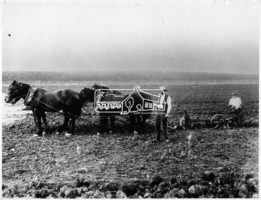
Photograph, James and Robert Ness, Garden Hill Farm, Kangaroo Ground
... garden hill farm james ness robert ness pioneers and painters ...Reproduced on p49 of 'Pioneers & Painters'This photo forms part of a collection of photographs gathered by the Shire of Eltham for their centenary project book,"Pioneers and Painters: 100 years of the Shire of Eltham" by Alan Marshall (1971). The collection of over 500 images is held in partnership between Eltham District Historical Society and Yarra Plenty Regional Library (Eltham Library) and is now formally known as the 'The Shire of Eltham Pioneers Photograph Collection.' It is significant in being the first community sourced collection representing the places and people of the Shire's first one hundred years.Digital image B&W Print 20 x 25 cm B&W Prtint 12.5 x 17.5 cm sepp, shire of eltham pioneers photograph collection, kangaroo ground, garden hill farm, james ness, robert ness, pioneers and painters -
 Eltham District Historical Society Inc
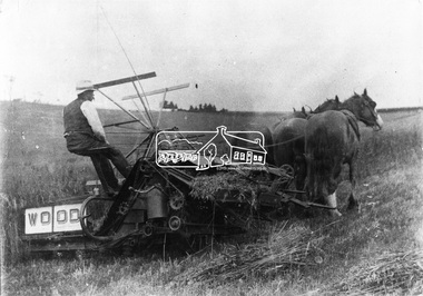
Photograph, James Ness harvesting oats, Garden Hill Farm, Kangaroo Ground
... garden hill farm james ness Digital image James Ness harvesting ...Source: Mr. R.B. Ness, Kangaroo GroundThis photo forms part of a collection of photographs gathered by the Shire of Eltham for their centenary project book,"Pioneers and Painters: 100 years of the Shire of Eltham" by Alan Marshall (1971). The collection of over 500 images is held in partnership between Eltham District Historical Society and Yarra Plenty Regional Library (Eltham Library) and is now formally known as the 'The Shire of Eltham Pioneers Photograph Collection.' It is significant in being the first community sourced collection representing the places and people of the Shire's first one hundred years.Digital imagesepp, shire of eltham pioneers photograph collection, kangaroo ground, garden hill farm, james ness -
 Eltham District Historical Society Inc
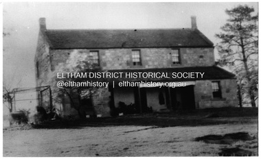
Photograph, "Pretty Hill", Kangaroo Ground. James Johnston's homestead
... "Pretty Hill", Kangaroo Ground. James Johnston's homestead... Johnston Family James Johnston Digital image "Pretty Hill ...Kangaroo Ground pioneers James Johnston (died 1895) with his wife Elizabeth commenced building this stone house on his Pretty Hill property, Kangaroo Ground in 1842. It was one of the oldest homes in the district till 1938 when new owner Mr Percy Cope, a master builder demolished the old building and a new brick building was erected in its place. Pretty Hill is one of the highest spots in the district with splendid views of the surrounding country.This photo forms part of a collection of photographs gathered by the Shire of Eltham for their centenary project book,"Pioneers and Painters: 100 years of the Shire of Eltham" by Alan Marshall (1971). The collection of over 500 images is held in partnership between Eltham District Historical Society and Yarra Plenty Regional Library (Eltham Library) and is now formally known as 'The Shire of Eltham Pioneers Photograph Collection'. It is significant in being the first community sourced collection representing the places and people of the Shire's first one hundred years.Digital imagesepp, shire of eltham pioneers photograph collection, kangaroo ground, pretty hill, stonen house, homestead, johnston family, james johnston -
 Eltham District Historical Society Inc
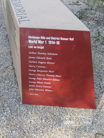
Photograph, Shire of Nillumbik World War One Memorials tour, 10 August 2016, 10 August 2016
As part of a program to acknowledge the Anzac Centenary Nillumbik Shire Council partnered with Yarra Plenty Regional Library to provide a bus tour with commentary of local sites of significance. These included Eltham township, the Shire of Eltham War Memorial at Kangaroo Ground, Christmas Hills war memorial, Hurstbridge memorial recreation park and finshed at Eltham Library to view the Writing the War exhibtion at Eltham Library Community Gallery. In May 2015 Nillumbik Shire Council received Anzac Centenary Local Grants Program funding for the restoration and enhancement of the Christmas Hills cenotaph as a project to commemorate the First World War An interpretative project lists names on the honour roll for Christmas Hills and District Born DigitalChristmas Hills and District Honour Roll World War 1 1914-1918 Lest we forget Arthur Stanley Ashmore James Edward Betts Herbert Eugene Borner Harry Conway* George Benjamin Muir Henry (Harry) Thomas Muir George Peter Maurice Saltau George Edwin Smith James Henry Sumner John Valentine Wilson* *Killed in actionworld war 1, war memorials, shire of nillumbik, christmas hills, interpretative signage, list, names, honour roll -
 Eltham District Historical Society Inc
Photograph, Entrance to Shire of Eltham Memorial Park, Garden Hill, Eltham-Yarra Glen Road, Kangaroo Ground, c.1923
View to south-east from Shire of Eltham Soldiers' Memorial Park showing the carriageway from the road to top of Memorial Park. Accompanying notes state that the entry gate was put in place in May 1921. Eltham and Whittlesea Shire Advertiser and Diamond Creek Valley Advocate Fri 21 May 1920 p 2 reported: Kangaroo Ground Memorial Park "It was decided to arrange for a working bee on Saturday, 29th inst., for the purpose of forming and gravelling the track leading to the Park, and of carrying out other necessary works." A history summary of the Shire of Eltham Soldiers’ Memorial Park • The summit at Garden Hill was a popular tourist lookout and picnic spot from the 1880s. Virtually the entire Shire of Eltham and beyond could be viewed from this location. • A local farmer, Mr Walter A. D. Wippell is credited as being the first to propose the idea of a war memorial park and offered £50 towards the purchase of the land. • The earliest public reference to this project is to be found in the local Advertiser newspaper edition of August 9th, 1918. A report of the August Council meeting records the Eltham Shire President, Cr. Robert White, saying: "some time back it was proposed that the Council obtain and place on an Honour Board in the Council Chamber [at Kangaroo Ground] containing names of the lads who had enlisted. Just recently however, it had been suggested that a more fitting memorial would be the obtaining of a piece of land on the summit of Garden Hill, Kangaroo Ground, and the formation of a memorial park in which a monument could be erected to represent the whole of Shire. If a couple of acres could be obtained a gentleman had promised to donate 50 pounds, and another one would fence it, and other contributions, he was sure, could be obtained." • Councillors were favourable of the proposal and the President, Shire Secretary and Shire Engineer were deputised to wait on Messrs Mess Bros. (the owners of the Garden Hill farm) and ascertain if they would gratuitously give the land. The Mess Bros. land adjoined the farm/stud of Mrs Fanny White (Cr Robert White’s mother), daughter of Andrew Harkness who established their property on Garden Hill around 1846. • Access to the land came in February 1919 when several Councillors and the Shire Engineer surveyed the actual two acres of '5 chains along the road and 4 chains deep'. The Engineer volunteered his services free to do this task. The Mess brothers however demanded £100 per acre but eventually agreed to take £50 per acre. • Entry from the Kangaroo Ground-Yarra Glen road was seen to be a problem and Mrs. White, who owned the land beside the park, was asked to donated a triangle of her property to allow this access. • By September 1919 returned soldiers were employed by the Shire and volunteers were called to clear the hilltop by ploughing up the rocks and clearing the area, the fencing was put into place and in May 1921 the Council erected three gates, within an archway, at the entrance to the drive and pathway to the summit. • Public subscriptions were sought through the Advertiser newspaper to beautify the site. The views of the Curator of the Melbourne Botanical Gardens were sought as to the ‘class of ornamental trees most suitable for planting in the Park area”. • The Memorial Park or Shire of Eltham Soldiers’ Memorial Park was officially opened by Mr. W.H. Everard, M.L.A., 3 September 1921. • In 1922 plans were made to place a War Memorial in the Park. Funds were donated by the Council of £250 and a challenge to the community, to match this money with contributions was met. • On Anzac Day 1923, 1,000 people gathered on the summit in the park for a memorial service. A much smaller group of about 50 people gathered around a newly constructed cairn and flagstaff in the afternoon of Anzac Day 1924 amidst rain and a squally southerly wind, the morning service being cancelled. • A meeting for those interested in establishing a War Memorial monument within the park was held in January 1924 and the Eltham Shire War Memorial League was formed and a design competition decided upon. • The Shire of Eltham War Memorial tower was built in 1926 at a cost of £1,023 and 5 shillings with locally quarried stone donated by Dr Ethel and Professor William Osborne. It was formally known as the ‘Shire of Eltham War Memorial’ and was unveiled on 11 November 1926. The large bronze inscription above the entrance to the tower states: SHIRE OF ELTHAM WAR MEMORIAL THESE MEN DIED FOR THEIR COUNTRY 1914 IN REMEMBRANCE THIS TOWER WAS BUILT 1918 • The Caretaker’s hut was built in 1927 with left over from the tower construction. • A returned soldier was appointed to act as caretaker for the memorials. Tiny Carrol, a huge man, was the first caretaker and lived in the stone hut. There was a push to have alterations made at one stage to provide additional rooms for a married caretaker but was rejected. • A new Caretaker Cottage was built in 1951 at a cost £2,500. The cottage had been subjected to raids by thieves three times during construction until a guard from the Returned Servicemen’s League was posted until its opening. • The War Memorial tower was re-dedicated by Sir Dallas Brooks on 8 November 1951, unveiling new bronze plaques containing the names of those who fell during the Second World War. Sir Dallas also officiated the opening of the new Caretaker’s Cottage. • A toilet block was built in 1965. • A further dedication of the Shire of Eltham War Memorial tower took place 11 November 2001 to recognise the men who fell in subsequent campaigns up to and including Vietnam. • Four land titles are involved: o The purchase of the two acres from owners Ruth Gosling, Alexander Mess, James Johnson Mess and Joseph Mess is recorded in two actions, the first being the payment of £100 for the two acres, the second showing that the Shire of Eltham did not get a transfer of title until 14th January 1952. o The access land donated by Mrs. Fanny White is dated 26 February 1924. A further need to widen the entry came after the deepening of the road cutting and another land donation was given by Sir Herbert Gepp, title dated 15th May 1952. This would have been about the time he sold off the former White ‘Garden Hill’ property. o The land reserve to increase the area and possibly allow a circuit road to be put in place on the western side of the park was purchased by the Shire of Eltham, title dated 16th February 1973. Rare photograph of the entrance to the Shire's Memorial Park during early stages of development prior to the erection of the Shire of Eltham War MemorialSepia photograph printed with white border with slight crack lower left hand corner and three significant vertical cracks fanning from lower centre edge to upper edge Digitally enhanced version to minimise impact of crackseltham-yarra glen road, entrance gate, garden hill, kangaroo ground, shire of eltham memorial park, shire of eltham war memorial, kangaroo ground war memorial park -
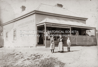 Eltham District Historical Society Inc
Photograph, Baker and Grocer shop, cnr. Main Road and York Street, Eltham, c.1902
Baker and Grocer store, cnr. Main Road and York Street, Eltham, early 1900s. Sign on side of building "Baker, Grocer & Summer Drinks" This image appears to be of the baker/grocery store after it was purchased in 1902 by Mrs Sarah Burgoyne and her husband, John James Thomas Burgoyne. It is possible that Mrs Sarah Burgoyne is the lady in front of the store with her eldest daughter, Charlotte and youngest son, James. Another daughter (Frances) and the family dog are watching from the doorway. In 1902 Mrs Sarah Burgoyne purchased from Wilfred Henry Johnston, the property on the southern corner of Main Road and York Street, Eltham, which consisted of a store and bakery establishment occupied by Mr. Luther Haley whose lease had expired around the same time. Mr. Haley had not been prepared to leave as he was unable to secure at Eltham a suitable house in which to carry on his business. Wilfred Johnston applied for an eviction of Hayley, which was heard at Eltham Courthouse in August 1902. Hayley advised he was building a place near the railway station which he expected to be done in about three weeks’ time. The court gave him the three weeks to vacate. Hayley’s new premises near the station became the present shopping district’s first shop and he ran it successfully till 1917 when the family moved to Clifton Hill, and he became a publisher. Their eldest child Leslie drowned in the Diamond Creek in early 1904, aged 12.Sepia photograph mounted on cardeltham, eltham bakery, grocer, john james thomas burgoyne, main road, sarah jane burgoyne (nee benson), summer drinks, york street -
Eltham District Historical Society Inc
Folder, James Hughes, 1890s
... teacher, Panton Hill, 1890s James Hughes Folder ...Folder of information on James Hughes, school teacher, Panton Hill, 1890sjames hughes -
 Eltham District Historical Society Inc
Newsletter, Newsletter, No. 237 December 2017
Contents: • The Carnival is Over….well just about! By Jim Connor • Society Christmas Function • 50 Years ago…..1967 by Liz Pidgeon • Our 50th Anniversary Celebration Dinner • Eltham 1950 s– Childhood Reminiscences – Part 1 by Ann Constable • A Squatter’s Life on the Plenty River at ‘Wanstead’: The 1837 Diary of James Louis Willis by Anne Paul • 80th Anniversary of Rob Roy Hill Climb • Montsalvat • Our Sponsors • Contacts for the Eltham District Historical SocietyThe Shire of Eltham Historical Society was formed in October 1967. The first newsletter of the Society was issued May 1978 and has been published continuously ever since on a bi-monthly basis. With the cessation of the Shire of Eltham in late 1994, the Society's name was revised to Eltham District Historical Society and this name first appeared with issue No. 103, July 1995. The collection of the Society's newsletters provides a valuable resource on the history of the Society's activities, office bearers and committee members, guest speakers and subjects of historical interest pertinent to the former Shire of Eltham and the Eltham District.A4 newsletter distributed to membersnewsletter, eltham district historical society, shire of eltham historical society -
 Orbost & District Historical Society
book, Key to the System of Victorian Plants, 1887 - 1888
Ferdinand von Mueller was born at Rostock, Germany, on 30 June 1825 , died at Melbourne, Australia, on 10 October 1896. He studied pharmacy and took his Doctor of Philosophy at the University of Kiel in 1847. He came to Australia in 1848 for health reasons and became a great botanical collector and writer. He was Victorian Government Botanist from 1853, and for a time Director of the Botanic Gardens. He travelled widely in Victoria and was on the A.C.Gregory expedition to northern Australia in 1855-57. He supported botanical exploration and collecting throughout the colonies. Charles Henry [Carl] Grove died on 17/4/1938 at Box Hill at the age of 88 and was buried in Orbost. Prior to coming to the Snowy River district, Carl worked as overseer on Buchan Station. In 1880, he selected land at Newmerella after first coming here in 1874 with early selector James A Robertson. He married Annie Robertson in 1876. Carl was a farmer, hop and seed grower and nurseryman. He was an elected Councillor of the newly formed Tambo Shire in 1882, and then in 1892 to the Orbost Shire where he served for many years filling varioius public roles. In 1911, he shifted to Queensland, but later returned to Victoria and died at Box Hill. (Ref. Nov 2014 Newsletter) Mueller was one of the first people to take a scientific interest in Victorian forests, and argued against indiscriminate clearing of land. This item is a useful research tool. It is associated with Carl Grove, a prominent early resident of Orbost.A black book with the title "Key To The System of Victorian Plants 1" in gold print.inside cover - "To Carl Grove from Baron Von Mueller March 1896"von-mueller-ferdinand botany-victoria plants-victoria grove-carl -
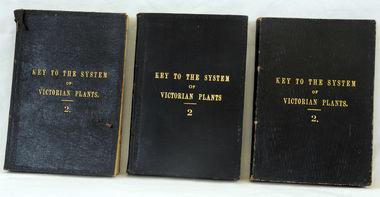 Orbost & District Historical Society
books, Robt. S. Bain, Key to the System of Victorian Plants 2, 1885
Ferdinand von Mueller was born at Rostock, Germany, on 30 June 1825 , died at Melbourne, Australia, on 10 October 1896. He studied pharmacy and took his Doctor of Philosophy at the University of Kiel in 1847. He came to Australia in 1848 for health reasons and became a great botanical collector and writer. He was Victorian Government Botanist from 1853, and for a time Director of the Botanic Gardens. He travelled widely in Victoria and was on the A.C.Gregory expedition to northern Australia in 1855-57. He supported botanical exploration and collecting throughout the colonies. 681.3 was presented to Carl Grove from G. Tadgell of Flemington. Charles Henry [Carl] Grove died on 17/4/1938 at Box Hill at the age of 88 and was buried in Orbost. Prior to coming to the Snowy River district, Carl worked as overseer on Buchan Station. In 1880, he selected land at Newmerella after first coming here in 1874 with early selector James A Robertson.He was one of the first selectors at Orbost - in 1880 he selected 320 acres at Newmerella, which he called „Ulinda‟ He married Annie Robertson in 1876. Carl was a farmer, hop and seed grower and nurseryman. He was an elected Councillor of the newly formed Tambo Shire in 1882, and then in 1892 to the Orbost Shire where he served for many years filling varioius public roles. In 1911, he shifted to Queensland, but later returned to Victoria and died at Box Hill. (Ref. Nov 2014 Newsletter) Mueller was one of the first people to take a scientific interest in Victorian forests, and argued against indiscriminate clearing of land. This item is a useful research tool. It is associated with Carl Grove, a prominent early resident of Orbost.Three copies of fabric bound book with a deep blue cover and the title, "Key To The System Of Victorian plants" in gold print. It has an ornate border around the edge.inside cover of 681.1 - To H. Grove, March 1891 Ulinda, Newmerella, Victoriaferdinand-von-mueller grove-carl botany plants-victoria -
 Orbost & District Historical Society
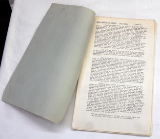
book, Grove, Carl, BUKAN MUNGEE
C.H. Grove spent about 40 years in the area, information is mainly derived from his own recollections and "reliable sources". Charles Henry [Carl] Grove died on 17/4/1938 at Box Hill at the age of 88 and was buried in Orbost. Prior to coming to the Snowy River district, Carl worked as overseer on Buchan Station. In 1880, he selected land at Newmerella after first coming here in 1874 with early selector James A Robertson.He was one of the first selectors at Orbost - in 1880 he selected 320 acres at Newmerella, which he called „Ulinda‟ He married Annie Robertson in 1876. Carl was a farmer, hop and seed grower and nurseryman. He was an elected Councillor of the newly formed Tambo Shire in 1882, and then in 1892 to the Orbost Shire where he served for many years filling varioius public roles. In 1911, he shifted to Queensland, but later returned to Victoria and died at Box Hill. (Ref. Nov 2014 Newsletter) This is a useful reference tool.A carbon copy of a typeset manuscript / transcript book entitled "Bukan Mungee" containing historical and geographical information of the area "bounded by the Snowy River in the east, the Tambo river in the west...and with the following leaseholds, Ensay, Gillingall, and Gelantipy on the north, with Kilmore and Corringle stations on the south..."grove-carl bukan-mungee corringle newmerella snowy-river tambo-river -
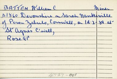 Ringwood and District Historical Society
Document - Index Cards, Ringwood - Incomplete set of 17 Index Cards with names of local residents from B to J
The index cards have very brief details of each personIncomplete set of 17 small Index Cards with names of local residents from B to J, biographical information, children, residences etc. Undated, and writer unknown. Names are: Batten, William C. - Miner; Brakewell, John - Labourer Cox, Joseph - Miner Curran, John - Storekeeper Cutts, Samuel - Publican Cutts, James Bennitt - Labourer Ditchburn, William - Brickmaker Drury, John R. - Miner Dynes,Joseph - Miner Eyre,Francis - Brickmaker Hill, David Gilchrist - Labourer Hill, John - Brickmaker Hill, Will Henry - Florist Hill, Ninian C. - Grazier Howship, Charles Burton - Mount cutter (pictures) Howship, Charles Lawrence - Picture framer Jones, George J - Burnt Bridge Hotel Keeper -
 Ringwood and District Historical Society
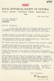
Letter, Letter from M. Greaves of the Royal Historical Society of Victoria to Mr J.K. McCaskill outlining a small number of aspects of early settlement of Ringwood, 16-Jul-58
Letter from M. Greaves of the Royal Historical Society of Victoria to Mr J.K. McCaskill outlining a small number of aspects of early settlement of Ringwood. +Additional Keywords: Lindsay, James / Pett, Joseph / Quigley, James / Wiggin, George Thomas / Cobb & Co / Railway / Lilydale / Kaolin discovery in Victoria / Antimony / Wood's Point Run / White Horse Hotel at Box Hill -
 Orbost & District Historical Society
lace, 1800-1900
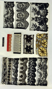
These laces belonged to Mrs.J. Pardew. Edward James Pardew died in 26/9/1927 aged 92. He came to Orbost from New Zealand in 1886 and selected 720 acres of hill land in the Brodribb area. He was a member of the first Orbost Shire Council. His daughter had a fruit & meat shop in McLeod Street. He was an inaugural vestryman of St James Church of England.Lace is an ornamental openwork fabric created by looping, twisting, braiding or knotting threads either by hand or by machine.This item is aesthetically significant and has a connection to an early Orbost settler.Twelve pieces of assorted laces on card - 3 cards.lace haberdashery cotsume accessories pardew-edward -
 Orbost & District Historical Society
black and white photograph/ poscards, Vogt. W.S, C1890 - 1920
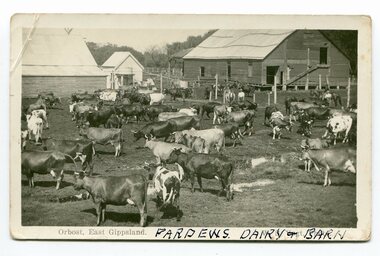
Edward James Pardew died in 26/9/1927 aged 92. He came to Orbost from New Zealand in 1886 and selected 720 acres of hill land in the Brodribb area. He was a member of the first Orbost Shire Council. His daughter had a fruit & meat shop in McLeod Street. He was an inaugural vestryman of St James Church of England. One of the most prominent farmers on the Snowy was John Gilbert, a large landowner. His breeding establishment was at Tullagoota, about two and a half kilometres down the river from Orbost.Dairying in the Orbost district was once a mainstay of the farming community. Today the properties are fewer and smaller.Two black / white photographs of dairy herds. 3188.1 - on front - printed -"ORBOST EAST GIPPSLAND"; hand-written - :PARDEWS DAIRY & BARN" 3188.2 - on front - printed - " W. S. VOGT"; hand-written - "DAIRY HERD TALLAGOOTA< ORBOST"dairying-orbost agriculture-orbost pardew-dairy tallagoota-dairy -
 Orbost & District Historical Society
black and white photographs, first half 20th century
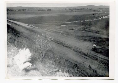
3255.1 is a photograph of the Princes Freeway construction of the roadway embankment at the foot of Newmerella Hill. 3255.2 is of the construction of the roadway, the Princes Freeway looking down from Newmerella toward Orbost. 3255.3 shows the Princes Freeway from Grandview , Newmerella, and shows the southern end of Ashby's Gulch with its bridge. 3255.4 is of the Princes Freeway showing the bridge across Ashby's Gulch and a train on the railway viaduct. Ashby's Gulch is named for the Ashby family. The Ashby family was one of the early settlers in Orbost at Newmerella. Roy Ashby, son of James Rowland Ashby and Edith Annie Hall, was born on 21 Nov 1892 in Orbost. Victoria. Australia and died in 1942 in Orbost. Victoria. Australia at age 50. Roy married Elsie May Stephens, daughter of James Stephens and Sarah Taylor, in 1920 in Victoria.Australia. Elsie was born on 15 Sep 1898 in Beaconsfield Tasmania.Australia and died in 1974 in Orbost Australia at age 76. Their children were: Roy Ashby, William Henry Ashby, Cordelia Valma Ashby and Edith Ashby. This photograph is associated with the construction of the main roads into Orbost. It is also connected to the Orbost to Bairnsdale Railway.Four black / white photographs of road construction and rail bridges.road-construction-newmerella princes-freeway-newmerella ashby's-gulch-newmerella orbost-railway -
 Ringwood and District Historical Society
Pamphlet, Land Sale Brochure Titled Eureka Plan Book - Seven Delightful & Valuable Ringwood Estates - circa 1925
Twenty page land sale brochure including photographs, subdivision features and local facilities. Additional flyer with conditions of sale and prices for estate blocks.Seven delightful and valuable Ringwood Estates called Bestpart, Paradise, Hill Top, Greenwood, Creek, Station, and School Estates. These nestle amidst the hills and valleys of beautiful Ringwood district. Also Goodluck Estate at Clarinda. Pamphlet marked as being From Mr. Farmer, No. 5 Flinders Court, Melbourne. Phone 988, 989 Central, or 55 Ringwood after 7 p.m. Plan of Ringwood School Estate includes William Street (later Kendall Street), Greenwood Avenue, Alton Street and Locke Street. Plan of Bestpart Estate, Ringwood, includes Bedford Road, Wilana Street, Greenwood Avenue, Caroline Street, Henry Street and Haig Street. Plan of Ringwood Station Estate includes Pitt Street, Bedford Road, Greenwood Avenue, Station Street, William Street (later Kendall Street, James Street, Wantirna Road, Caroline Street, Henry Street, Ellison Street and Haig Street. Plan of Geenwood Estate, Ringwood, includes Prussian Road (later Geenwood Avenue). Plan of Paradise Estate, Ringwood, includes Canterbury Road, Dandenong Road (Wantirna Road), Luck Street and Paradise Road. Plan of Creek Estate, Ringwood, includes Dandenong Creek, Wantirna Road and Gordon Crescent. Plan of Hill Top Estate, Ringwood (later Heathmont area), includes Heathmont Railway Station, Heathmont Road, Balfour Avenue, Lilian Street, Edith Street, Edna Street and Great Ryrie Street. Plan of Goodluck Estate, Clarinda, includes Talbot Avenue, Good Street, Luck Street, and Centre Road in locality plan between Oakleigh and Clayton Railway Stations. -
 Ringwood and District Historical Society
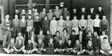
Photograph, Ringwood State School -Class photograph - Grade 5A, 1956
Black and white photograph - Grade 5A, 1956"Attached to photograph" Back Row- L to R: Wally Zielinski, Lylle Reeves, Mal Corin, T Cartright, Terry Segren, Kevin Burden, Wayne Ennis, ?, B James, Ian Simpson, Arthur Wigley, Doug Sjorgren. 2nd Row - L to R: Ian McLeave, Neal McCarten, Tom Guest, Margaret Cleator, Helen Bird, June Robinson, Marg Allsop, Susanne King, Olwyn Hayes, Lynette Broadway, ?, Alan Byrne, Maurice Johnson. 3rd Row - L to R: Lawrence Sumpter, Janice Bomford, Glenys Paul, Rhonda Thompson, Anita Hill, Pat Carpenter, Carol Pavey, Erica Burns, Lorraine Guscott, Angela Ochram, Kathleen Haywood. Front Row - L to R: Stan Bjerking, Ian Marshall, Barry Cooper, Robin Harris, Les Pattendon, Rod Clutterbuck, Kevin Divola, Kenny Gowers, Terry Wood, Ian Wilton. Absent - Dawn Riedel Teacher: Mr Reid. -
 Ringwood and District Historical Society
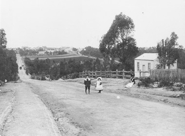
Photograph, Addison home 1902 Ringwood in background
Black and white photograph of scene showing unmade road with two children, a boy and a girl standing outside a small wooden building. Lady is sitting by the side of road. Road dips down to a bridge then rises again towards distant settlement in background. (3 copies)Typed below enlarged photo, "Addison home, 1902 - Opposite present St. Paul's, Warrandyte Road". Written on backing sheet, "Andersons Creek Rd. 1903. Mrs. Addison (Annie Kennedy) and family - Annie, born 1897 and William. Their house at right was on a 5 acre block. Ringwood in background". Backing sheet of another copy reads, "Andersons Creek Road 1902 (Warrandyte Rd. looking south). Mrs. Addison (Annie Kennedy) and family. Annie (Jnr), born 1897 and Samuel John James William, born 1894. Their home, at right, was on a 5 acre block. Ringwood in background - burned down by pet magpie. T. Grant's land ploughed - now Eastland. Adelaide St. seen on right of it. Mullum Creek Bridge at foot of hill". Typed below this photograph, "Warrandyte Rd. Ringwood looking south from near Mullum Rd. Ringwood in background. Maroondah Highway at top of hill with Mullum Creek bridge seen in dip - 1902".