Showing 4052 items matching "surveying"
-
 Bendigo Military Museum
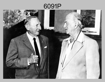
Photograph - Army Survey Regiment – CAPT Jack Cullen (Ret), Fortuna, Bendigo, c1978
This is a photograph of CAPT Jack Cullen (Ret) and an unidentified person besides the front steps of Fortuna Villa, Bendigo, c1978. Jack Cullen served for many years in the Royal Australian Survey Corps from 1920 to 1952, after active service with the AIF in WW1. His service at Fortuna began in 1944 when he was a Lieutenant in charge of a map compilation section. Jack Cullen’s service is covered in more detail with additional historic photographs, in Valerie Lovejoy’s book 'Mapmakers of Fortuna – A history of the Army Survey Regiment’ ISBN: 0-646-42120-4This is a photograph of CAPT Jack Cullen (Ret) and an unidentified person at the Army Survey Regiment, Fortuna, Bendigo, c1978. The photograph was printed on photographic paper and is part of the Army Survey Regiment’s Collection. The photograph was scanned at 300 dpi. Photo, black & white, c1988: L to R: CAPT Jack Cullen (Ret), unidentified person‘Jack Cullen’ is annotated on back of the photoroyal australian survey corps, rasvy, army survey regiment, army svy regt, fortuna, asr -
 Bendigo Military Museum
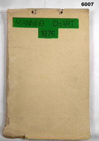
Document - Army Survey Regiment Manning Chart 1976, 1976
This document contains detailed photocopies of reports of Army Survey Regiment’s staff manning from December 1975 to August 1976. Each monthly report provided to Directorate of Survey covered the allocation of staff to Regimental Headquarters and its four sub units comprising Headquarters, Air Survey (Topographic), Cartographic and Lithographic Squadrons. Each Squadron’s troop or section structure was represented by a wire diagram with soldiers and/or civilians names assigned to rank based established positions. A detailed table at the end of each report sumarised Army Survey Regiment’s posted strength by employment category and rank.Manilla cardboard folder containing 83 photocopied pages of staff posted to the Army Survey Regiment. Pages are fixed to the folder by a metal fastener. The title of the folder is written in black ink on a green tape background.royal australian survey corps, rasvy, army survey regiment, army svy regt, asr, fortuna -
 Stawell Historical Society Inc
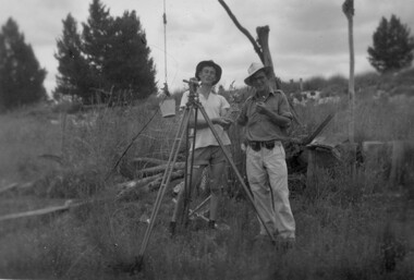
Photograph, Stawell Geodetic Survey at work. c1940's
Taken while surveying western half of Victoria to South Australian Border.Theodolite in foreground. Behind Surveyor in hat, shirt, long pants. Directly behind is Survey technician in hat, Tee shirt and shorts. Surveyor unknown. Assistant Alan Edward Tangey of Stawell. Reverse 4 2 2 6 -
 Federation University Historical Collection
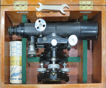
Instrument - Scientific Instrument, Dumpy Level, 05/1950
... surveying ...Used for surveying classes at the Ballarat School of Mines.Telescope with cross hairs and stoidia wites. Internal focussing. Vertical tilt adjusted with vernier mocrometer screw mirror lid longitudinal bubble level. Pea bubble level on plate. Housed in wooden storage carry box. Fits tripod cat. no. 4118Serial number 67543 On box lid in white paing "L 6". In yellow paing "59". Inside box lid - Manufacturers label; grades table label, calibration label reading "instrument No 67 543, date 13.5.50" (ink faded) constant: +0.19 ft"dumpy, level, surveying, scientific instrument, e.r. watts & son ltd, ballarat school of mines -
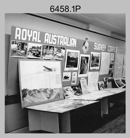 Bendigo Military Museum
Photograph - Royal Australian Survey Corps role and technical capabilities display, c1960s
This is a collection of four photographs taken in the 1960s of Royal Australian Survey Corps displays promoting its role and technical capability to acquire, process and disseminate topographic information to the Australian Defence Force. Map products formed a large part of this topographic Support. The photos may have been taken at a Careers Expo or a Department of Defence promotion. It is possible the photos were taken at separate events. This is a collection of four photographs taken in the 1960s of Royal Australian Survey Corps displays promoting its role in Defence and technical capabilities. The black and white photographs were printed on photographic paper and are part of the Army Survey Regiment’s Collection. The photographs were scanned at 300 dpi. .1) to .4) - Photo, black & white, 1960s. Royal Australian Survey Corps Display at unknown location.There are no annotations.royal australian survey corps, rasvy, army survey regiment, army svy regt, fortuna, asr -
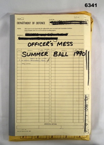 Bendigo Military Museum
Administrative record - Army Survey Regiment Officers Mess Ball 1990, Army Survey Regiment, Bendigo, 12 Feb - 8 Mar 1990
The Army Survey Regiment held Annual Balls at Fortuna Villa. This folder contains the documentation for the Logistics and activities associated with the planning and running of the Officers Mess Summer Ball held in 1990.Manilla Correspondence Folder with grey cloth binding containing correspondence about the Army Survey Regiment Officers Mess Summer Ball of 1990.royal australian survey corps, rasvy, fortuna, army survey regiment, army svy regt, asr -
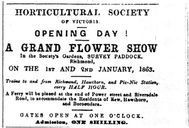 University of Melbourne, Burnley Campus Archives
Newspaper - Newspaper Cutting, The Australian, Horticultural Society of Victoria Opening Day, 1862
The Survey Paddock eventually became part of the Burnley Horticultural College.Photocopy of the top half of the front page of The Australian, December 27, 1862. In the top right corner is a notice of the opening day of a grand flower show in the gardens of the Horticultural Society in the Survey Paddock, Richmond.the australian, flower show, survey paddock, horticultural society of victoria, opening of burnley gardens, advertisement -
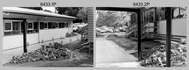 Bendigo Military Museum
Photograph - Air Survey Squadron building refurbishment - Army Survey Regiment Fortuna, Bendigo, c1982
This set of 20 black & white photographs of the refurbishment of Air Survey Squadron’s production areas, was taken in circa 1982. These refurbishments were most likely in preparation of the AUTOMAP 2 production system and to accommodate the expansion of the Army Survey Regiment’s work force. This photo set also includes the exterior and interior of a new building - 16A, a modular building of several sections transported in and joined together as part of the expansion. Another modular building - 16B was added later in the 1980s to accommodate Technical Services. The two buildings eventually were removed after Fortuna was sold by Defence in 2008.This set of 20 black & white photographs of the refurbishment of Air Survey Squadron’s production areas, was taken in circa 1982. The photographs are on 35mm negative film. They are part of the Army Survey Regiment’s Collection. The photographic negatives were scanned at 96 dpi. .1) to .2) - Photo, black & white, c1982. Air Survey Squadron building refurbishment. Pathway between Building 16 and Building 16A. .3) to .4) - Photo, black & white, c1982. Air Survey Squadron Building 16 refurbishment. .5) - Photo, black & white, c1982. Air Survey Squadron’s CAPT Chris ‘Monty’ Gehrmann. .6) - Photo, black & white, c1982. AUTOMAP 1 system, L to R: SGT Jim Gill, unidentified. .7) - Photo, black & white, c1982. AUTOMAP 1 system, SGT Bruce Bowers. .8) - Photo, black & white, c1982. AUTOMAP 1 system, unidentified staff. .9) - Photo, black & white, c1982. Technical Services - L to R: Tony Spurling, Joe Farrrington. .10) - Photo, black & white, c1982. Technical Services - Tony Spurling. .11) to .12) - Photo, black & white, c1982. Technical Services, unidentified staff. .13) - Photo, black & white, c1982. Air Survey Squadron, L to R: SPR Nick Van Dalen, SSGT Les Dixon, unidentified. .14) - Photo, black & white, c1982. Air Survey Squadron, L to R: SGT Greg Byers, WO1 Graeme Birrell. .15) - Photo, black & white, c1982. Air Survey Squadron, L to R: SSGT Bruce Gordon, CPL Dave Irving, SGT Phil Meagher, SSGT Brett ‘Dutchy’ Van Leeuwin. .16) - Photo, black & white, c1982. Air Survey Squadron, L to R: SGT Mick Hogan, CPL John Gilbert, SPR Lorraine (Daly) Talbot-Smith, SPR Santina (Argetto) Straube. .17) - Photo, black & white, c1982. Air Survey Squadron, L to R: CPL Dave Irving, SSGT Bruce Gordon, SGT Phil Meagher, SSGT Brett ‘Dutchy’ Van Leeuwin. .18) - Photo, black & white, c1982. Air Survey Squadron, L to R: CPL Dave Irving, SGT Phil Meagher. .19) - Photo, black & white, c1982. Air Survey Squadron, L to R: SPR Lorraine (Daly) Talbot-Smith, SGT Mick Hogan, CPL Dave Irving. .20) - Photo, black & white, c1982. Air Survey Squadron, L to R: SGT Phil Meagher, CPL Dave Irving, SSGT Brett ‘Dutchy’ Van Leeuwin, SSGT Bruce Gordon,.1P to .20P – no annotationsroyal australian survey corps, rasvy, army survey regiment, army svy regt, fortuna, asr, photogrammetry, automap 1 -
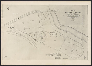 University of Melbourne, Burnley Campus Archives
Photograph - Plan of Burnley Gardens
"This plan is a copy of a copy of the survey made by Mr. Turner in 1926. The original plan and field notes are missing _ file Rs 3529" Signed by _signature unreadable_ -
 Flagstaff Hill Maritime Museum and Village
Map - Survey Map, F.F. McGovern, Yangery - County of Villiers, 1884
A surveyor was employed to measure the land designated as Yangery, County of Villiers, in the Borough of Warrnambool. The area on the map is similar to the earlier Farnham Survey undertaken by William Rutledge in the 1850's. Warrnambool was a Borough between 1863-1883. Coutours, waterways, sea and other significant points are shown. The distances are accurately measured. This survey map was used for planning future land sales, recreation areas and roads. WILLIAM RUTLEDGE (1806-1876) William Rutledge surveyed the land known as Farnham in southwest Victoria in 1843. His tenants made him a profitable business from working the land there. In 1863 Rutledge moved from nearby Port Fairy to Farnham and became very successful in breeding sheep, which he imported from J.R. Kirkham of Lincolnshire, England. He also bred horses on his land. The survey map of Yangery is important for its connection with renowned surveyor William Rutledge. The map shows the growth of landholders in the district when compared to the original Rutledge survey of the 1850's.Survey map of Yangery, titled "Yangery - County of Villiers". Printed on white paper, mounted on brown paper. c. 1863-1876. Comments printed on the Map include; Special Survey by William Rutledge, Photo-lithographed at the Department of Lands and Survey, Melbourne by W.J. Burson, Price 1/- [one shilling]. Scale is in Chains. Map has boundaries of Koroit Borough, Meerai, Purnim, Wangoom, Borough of Warrnambool, Mentions the Proposal of Tower HIll for Public Recreation. The map names the owners of the land at that time. Hand written pencil marks and figures and "Sauls fence" drawn on map. Hand written pencil markes and figures and "Sauls fence" drawn onto map. "For Department Use only". "Scale: 8 chains to 1 inch" flagstaff hill, warrnambool, shipwrecked-coast, flagstaff-hill, flagstaff-hill-maritime-museum, maritime-museum, shipwreck-coast, flagstaff-hill-maritime-village, county of villiers map, yangery district, w.j. burson, borough of warrnambool, koroit, purnim, meerai, wangoom, proposal of tower hill for public recreation, special survey by william rutledge, william rutledge, farnham, lincolnshire sheep, clydesdale -
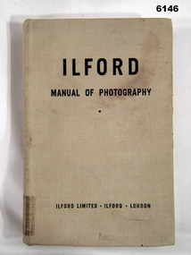 Bendigo Military Museum
Manual - Ilford Manual of Photography, Ilford Limited, Henry Greenwood &Co. Ltd. & Percy Lund, Humphries & Co. Ltd, First Published in October 1942
Manual describing all facets of photography using Ilford Cameras and includes developing and printing of photographs. The map making production at the Army Survey Regiment, Bendigo, made extensive use of photographic processes.A5 sized book, Hard Covers front and back. 470 numbered glossy pages.Inside front cover - "L33", stamp - "EXPENDABLE STORES" (twice), "Unreadable signature - QM 30/7/82", Stamp- "AHQ Survey Regiment, Royal Australian Survey Corps" Handwritten - Accession No 167 (and then crossed out), Stamp "29" First Page "15/-", Stamp "2 Topo Svy Coy, Powlett Street Training Depot (partly crossed out), Stamp Technical Book and Magazine Co, 295 -299 Swanston St. Opp Old Melbourne Hospital cert 2041, Melbourne. Title Page - "Accession No16, stamp 2 Topo Svy Coy Powlett Street Training Depot, East Melbourne" Stamp - "AHQ Survey Regiment, Royal Australian Survey Corps" - Accession No 167 (faded). Back Cover - Stamp - "AHQ Survey Regiment, Royal Australian Survey Corps"royal australian survey corps, rasvy, fortuna, army survey regiment, army svy regt, asr -
 Kew Historical Society Inc
Plan, Survey Plan, Park Hill Road, Kew, 1880-1890
The streets identified on the survey plan - Cotham Road, Park Hill Road East, Park Hill Road West in Kew were each gazetted by the Victorian Government in 1865. The hand-coloured survey plan was completed by Holland Loxton, Town Clerk and Surveyor of the Borough of Kew from 1866. The unnamed survey plan includes names of land owners in addition to measurements (2 chains to 1 inch) and streets. Named owners include Webster, Payne and Francom which will enable us to narrow down the creation date of the survey.Handdrawn survey plan by a former surveyor and town clerk of KewHand drawn and coloured survey plan created by Holland Loxton, Surveyor and Town Clerk of Kew, showing land owned by Payne in Park Hill Road, Kew. The plan includes street names, land measurements and land owners.surveys - kew, maps - kew, holland loxton, park hill road - kew, holland loxton -- surveyor, survey plans -- parkhill road -- kew (vic.) -
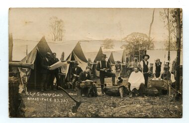 Orbost & District Historical Society
black and white photograph, July 27 1907
This is a camp of survey workers surveying the railway line . They were camped at Mossiface in 1907. It has been sent as a postcard - "Dear Miss Ross, Just a card, hoping you are well etc, trust you have not forgotten our trip. I forgot to get the name of the street in Hobart of Mr Benjamin or Temple?????? Sufficient. Yours sincerely H.R. Gordon". It has been dated September 30th 1907. There had been men surveying in East Gippsland from the late 19th century. Railway surveyors advocated two lines beyond Bairnsdale – one via Bruthen and the Tambo Valley to Omeo, the other via Swan Reach and Colquhoun to Orbost, then on to Bendoc and the border. With all the argument and feuding between the warring factions, by the end of 1891, the Parliamentary Railways Standing Committee gave up in despair of trying to reach any agreement and abandoned the idea altogether. Finally, with all problems solved, the first sod was turned at Mossiface on 9.1.1912, the government sticking to the original route in the 1890 survey .This is a pictorial record of a surveyors' camp in the early 20th century. The Bairnsdale to Orbost Railway was a significant contributor to the economy of Orbost until it closed.A black / white photograph / postcard of a group of men at a campsite. In the background is a row of tents. on the right side is a clothes line with several sheets hung over it. Two men are studying a map or chart; one man is sitting with a cloth around his shoulders while another is standing behind him cutting his hair; one man is washing cloth in a tin tub; another appears to be stirring a pot; others are sitting reading or just observing.on front - handwritten is " R.L.Y.S. SURVEY CAMP MOSSIFACE 27.7.07" on back is a letter - "Dear Miss Ross.............yours sincerely ????? Gordon"surveying-railway east-gippsland-railway mossiface-survey-camp -
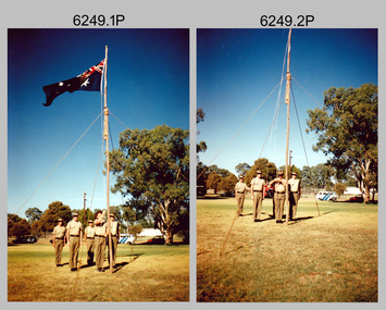 Bendigo Military Museum
Photograph - Lowering of the Australian Flag by Army Survey Regiment personnel, Australia Day, Kerang, 1996
These two photographs of a contingent from the Army Survey Regiment lowering the Australian flag were taken on Australia Day in Kerang, Victoria on the 26th of January 1996. Most units of the Australian Defence Force (ADF) provide contingents to regional towns in their local area to assist in commemoration ceremonies on days of national significance, such as Australia Day, ANZAC Day and Remembrance Day. This was most likely one of the last occasions before the closure of the Army Survey Regiment. The use of an improvised flagpole is unknown.These two photographs of a contingent from the Army Survey Regiment lowering the Australian flag, were taken on Australia Day in Kerang, Victoria on the 26th of January 1996. The photographs were printed on photographic paper and are part of the Army Survey Regiment’s Collection. The colour photographs were scanned at 300 dpi. .1) and .2) - Photo, colour, contingent of unidentified Army Svy Regt personnel. There are no annotations.royal australian survey corps, rasvy, army survey regiment, army svy regt, fortuna, asr, kerang shire, australia day -
 Forests Commission Retired Personnel Association (FCRPA)
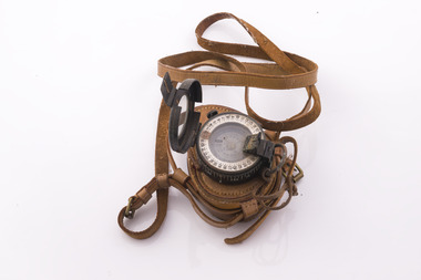
Prismatic Compass with leather case and strap, Ex Army 1940s
... Surveying ...A prismatic compass is a common navigation and surveying instrument which was used extensively by the Forests Commission The compass most commonly used to run a traverse line. The compass calculates bearings of lines with respect to magnetic needle. A magnetic deviation correction was needed to convert the reading to a true bearing The compass could also determine angles between the traverse and waypoints (such as hilltop features). Commonly used for navigation. Largely replaced by modern GPS technology.Ex Army WW2 prismatic compass with leather case and strap. Rugged design and made of metal the internal compass plate floats on oil to help it stabilise The user lines up the direction of travel with the hair sightline in the fliptop cover and readings are taken through the viewfinder prism (hence the name).forest measurement, surveying, forests commission victoria (fcv) -
 Federation University Historical Collection
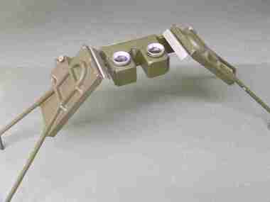
Instrument - Scientific Instruments, Universal Stereoscope
... surveying ...Initially made for and used by the military forces. Subsequently acquired (as army surplus equipment?) by the Ballarat School of Mines. Used in Surveying classes.A stereoscope arranged for positioning over a horizontal surface stored in a sturdy grey wood carry case. Spare set of mirrors attached to inside of box lid.scientific instruments, surveying, ballarat school of mines, stereoscope, map reading -
 Bendigo Military Museum
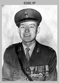
Photograph - CO of the Army Headquarters Survey Regiment - LTCOL Lionel ‘Bill’ Sprenger MBE MID, Fortuna, Bendigo, 1969
These three formal photos of LTCOL Lionel ‘Bill’ Sprenger MBE, MID were taken at the Army Headquarters (AHQ) Survey Regiment, Fortuna, Bendigo on the 30th of September 1969. LTCOL Bill Sprenger MBE, MID joined the Australian Army on the 10th of June 1940 and after rising through the ranks, his career culminated in his appointment as CO of the Army Survey Regiment from 1969 to 1970. Despite suffering debilitating poor health during his appointment, LTCOL Sprenger MBE, MID led the Regiment on the unit’s first Freedom of Entry Parade held in Bendigo on the 14th of June 1970. For more information on this occasion, refer to item 6020.8P. Unfortunately, LTCOL Bill Sprenger MBE, MID passed away on the 5th of December 1970 and was farewelled with a full military funeral. He is remembered as a model of good leadership. More information on LTCOL Sprenger’s tenure as CO of the unit is provided in pages 98 to 99, 102 and 134 of Valerie Lovejoy’s book 'Mapmakers of Fortuna – A history of the Army Survey Regiment’ ISBN: 0-646-42120-4.These three formal photos of LTCOL Lionel ‘Bill’ Sprenger MBE, MID were taken at the Army Headquarters (AHQ) Survey Regiment, Fortuna, Bendigo on the 30th of September 1969. The black and white photographs were printed on photographic paper and are part of the Army Survey Regiment’s Collection. Photo .1) was scanned at 300 dpi and photos .2) & .3) were scanned at 600 dpi. .1) to .3) - Photo, black & white, 1969, LTCOL Lionel ‘Bill’ Sprenger MBE, MID - CO of AHQ Survey Regiment.‘Unit Photos 30 Sept 1969’, ‘1 Topo Svy Tp’, ‘ LT COL Sprenger’ . Note - Yellow tag is annotated with incorrect date (1970). royal australian survey corps, rasvy, army survey regiment, army svy regt, fortuna, asr -
 Bendigo Military Museum
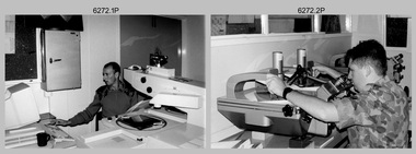
Photograph - Aerotriangulation Production – Army Survey Regiment, Fortuna, Bendigo, c1993
This is a collection of eight photographs of Air Survey Squadron personnel operating aerotriangulation equipment at the Army Survey Regiment at Fortuna, Bendigo, c1993. PUG4 devices were used by technicians to stereoscopically view the photography containing the survey control points and the mapping aerial photography. The Control points were transferred from the control photography to the mapping diapositives of aerial photography by drilling their locations into the photographic emulsion. The Zeiss (Jena) Stecometer analytic stereocomparator for air photography shown in photo .1P was introduced at Air Survey Squadron in 1963. Wild PUG4 point transfer devices shown in photos .2P to .4P were introduced in c1968 superseding the PUG2 devices. See item 6195.19P for more photos and descriptions of Air Survey Squadron personnel and aerotriangulation equipment.This is a set of eight photographs of Air Survey Squadron personnel operating aerotriangulation equipment at the Army Survey Regiment at Fortuna, Bendigo, c1993. The photographs were on 35mm negative film and were scanned at 96 dpi. They are part of the Army Survey Regiment’s Collection. .1) - Photo, black & white, c1993, Zeiss (Jena) Stecometer, SPR Kim Baker. .2) - Photo, black & white, c1993, Wild PUG4 point transfer device, CPL Paul Bouton. .3) to .4) - Photo, black & white, c1993, Wild PUG4 point transfer device, L to R: CPL Darren Scott, CPL Paul Bouton. .5) to .6P) - Photo, black & white, c1993, CPL Doug Willis. .7) - Photo, black & white, c1993, WO2 Noel ‘Macca’ McNamara. .8) - Photo, black & white, c1993, SGT Barry Miller..1P to .8P - There are no annotations.royal australian survey corps, rasvy, army survey regiment, army svy regt, fortuna, asr, aerotrig -
 Glenelg Shire Council Cultural Collection
Photograph - Photograph - aerial view of railway line between Heywood and Rennick, 03/05/1952
Victorian Railways aerial survey record print of the railway line between Heywood and Rennick (S.A. border) Black and white, white vertical strip on imageBack: 'Heywood - Rennick 21450 - 19721 266m 72 c' - all black ink. White sticker, black print 'Marp' Purple VR aerial survey stamp. '3 May 1952' - black stampvictorian railways, aerial photography -
 Bendigo Military Museum
Administrative record - Army Survey Regiment Officers Mess - Insurance Invoices and Receipts, Army Headquarters Survey Regiment, 1957-1967
Various Insurance Company invoices and receipts, all pertaining to the Officers Mess at Army Headquarters Survey Regiment Foolscap size folder. All paper pages of various sizes from a number of different Insurance companies pertaining to the Officers Mess at AHQ Survey Regiment during the years 1957 to 1967.royal australian survey corps, rasvy, fortuna, army survey regiment, army svy regt, asr -
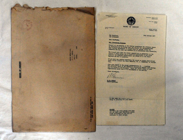 Orbost & District Historical Society
document, 18th October, 1977
This survey had been sent to the Orbost Rifle Club c/- C. Curtis.The Shire of Orbost was a local government area about 380 kilometres (236 mi) east of Melbourne, the state capital of Victoria, Australia. The shire covered an area of 9,347 square kilometres (3,608.9 sq mi), and existed from 1892 until 1994 when it was merged as part of East Gippsland Shire Council.A nine page document stapled in the left-hand corner. It is a recreational survey issued by the Shire of Orbost. It is inside a a large manila envelope which is addressed to the Orbost Rifle club. It contains a covering letter and a form.survey shire-of-orbost orbost-rifle-club -
 Bendigo Military Museum
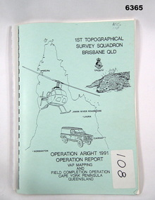
Administrative record - Royal Australian Survey Corps Report on Operation Aright 91 conducted by 1 Field Survey Squadron 1991, 1 Fd Svy Sqn, 7 Oct 1991
Royal Australian Survey Corps Operation Aright 91 (Field Completion) was a Field Verification and Vital Assets Protection (VAP) Mapping Operation conducted in Far North Queensland during the period 18 Jun - 29 Jul 1991 by 1 Fd Svy Sqn. The Operation covered the 1:250,000 Map area of SD54-16 Hann River and SE54-7 Normanton.Pale Blue cover with motifs of North Queensland, crocodile, RASvy Corps Badge, Army Helicopter and Land rover. Contains an A4 paper report of typed pages and diagrams secured by a plastic binder.Cover Hand annotated "ASS 108" (Air Survey Sqn, copy 108)royal australian survey corps, rasvy, fortuna, army survey regiment, army svy regt, asr -
 Bendigo Military Museum
Photograph - Army Survey Regiment’s Officers, Warrant Officers and Sergeants and Squadrons, at Fortuna, Bendigo, 1982
This is a set of six staff photographs of the Army Survey Regiment’s Officers, Warrant Officers and Sergeants, and each of its four Squadrons at Fortuna, Bendigo in December 1982. Note - Air Survey Squadron’s photo was probably taken in July 1982 as they appear in winter dress. Air Survey Squadron was responsible for aerotriangulation, photogrammetric feature extraction and the AUTOMAP 1 system. Typical tasks were flight planning the acquisition of aerial photography, pugging, mensuration and block adjustments, photogrammetric extraction of topographic features from aerial photography, digital feature editing, map compilation, operating the scanner/plotter, operating the AUTOMAP 1 system and computer programming by civilians. Cartographic Squadron was responsible for the production of the following military products: Joint Operation Graphics, small-scale RAAF Air Charts, large-scale topographic line maps and orthophotomaps. Cartographic technician tasks were scribing, compiling, retouching, masking, type setting, type stickup, terrain embossing, correcting and proving quality control. Headquarters Squadron was responsible for the planning and coordination of map production and contracts. It also performed administrative and support functions such as personnel administration, pay, finance, transportation, records, map Library, kitchens, messes and facility maintenance. It was staffed by Army personnel from RASvy, RACT, AACC, RAAOC and RAEME corps. Other supporting staff at this time included the RAAF Liaison Officer, RAN Liaison Officer and several civilians employed in administration, the Q-Store and grounds maintenance. A component of the Army Svy Regt’s cartographic map production was carried out by the Detachment, a sub-unit located at Bonegilla next to the School of Military Survey. Lithographic Squadron was responsible for the reproduction of map materials and printing of military map products. The main tasks undertaken by photographic technicians were photographic enlargements, reductions and duplication of map reproduction material and processing of aerial photography. Printing technician tasks included platemaking, offset printing, map stock despatching and proofing.This is a set of six staff photographs of the Army Survey Regiment’s Officers, Warrant Officers and Sergeants, and its four Squadrons, at Fortuna, Bendigo, 1982. The black and white photographs were printed on photographic paper and are part of the Army Survey Regiment’s Collection. The photograph was scanned at 300 dpi. No personnel are identified. No personnel are identified. .1P – Annotated on front “OFFICERS MESS DEC ’82” .2P – Annotated on back “SGTS MESS DEC ’82” .4P– Annotated on front “CARTO SQN DEC ’82” .5P– Annotated on front “HQ SQN DEC ’82”royal australian survey corps, rasvy, army survey regiment, army svy regt, fortuna, asr, air survey, carto, litho -
Lakes Entrance Historical Society
Book, Morrissey D W and Morrissey E W, Lakes Entrance a Short History and Tourist Guide
A short history of lakes Entrance from early settlement, including references to forest survey, land sales, shipping, fishing industry and development of the town and tourist industry A short history of lakes Entrance from early settlement, including references to forest survey, land sales, shipping, fishing industry and development of the town and tourist industrysettlers, land settlement -
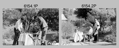 Bendigo Military Museum
Photograph - Silver Service Morning Tea – Army Survey Regiment, Fortuna, Bendigo, 1991
These six photos were taken in the grounds of the Army Survey Regiment, Fortuna in spring 1991. MAJ Ray Redman appears in his mess dress by the Roman fountain, serving a silver service morning tea to CPL Pat Drury, as a result of a losing bet on the 1991 Rugby League Grand Final. Pat Drury was a very keen rugby league supporter and followed Penrith, who lost its first Grand Final appearance to the Canberra Raiders in 1990. Penrith reversed the result the following year against Canberra winning their first premiership. This occasion is covered on page 152 of Valerie Lovejoy’s book 'Mapmakers of Fortuna – A history of the Army Survey Regiment’ ISBN: 0-646-42120-4.This is a set of six photographs of two Army Survey Regiment personnel in the grounds of Fortuna, Bendigo, 1991. The photographs were on 35mm negative film and were scanned at 96 dpi. They are part of the Army Survey Regiment’s Collection. .1) to .6) - Photo, black & white, 1991, MAJ Ray Redman and CPL Pat Drury. No personnel are identified.royal australian survey corps, rasvy, army survey regiment, army svy regt, fortuna, asr -
Glenelg Shire Council Cultural Collection
Photograph - Photograph - Aerial Photo railway line between Heywood and Rennick, 03/05/1952
Victorian Railways aerial survey record print of the railway line between Heywood and Rennick (S.A. border) Black and white, white vertical strip on imageFront: 'to Rennick, Heywood from Melbourne' in the whites strip Back: 'Heywood - Rennick 21079 - 19370 235m72c Heywood' - all black ink. Purple VR aerial survey stamp. '3 May 1952' - black stamp -
Glenelg Shire Council Cultural Collection
Photograph - Photograph - Aerial Photo railway line between Heywood and Rennick, 03/05/1952
Victorian Railways aerial survey record print of the railway line between Heywood and Rennick (S.A. border) Black and white, white vertical strip on imageFront: Annotations in black texta added at a later date Back: 'Heywood - Rennick 21451 - 19722 267m 1c ' - all black ink. Purple VR aerial survey stamp. '3 May 1952' - black stamp -
Glenelg Shire Council Cultural Collection
Photograph - Aerial Survey Railway Record Print - 1952, 03/05/1952
These photos were found in a car that was left for recycling.Victorian Railways aerial survey record print of the railway line between Heywood and Rennick (S.A. border) Black and white, white vertical strip on image.Front: 'to Rennick, Heywood from Melbourne' in the white strip Back: 'Heywood - Rennick 21069 - 19360. 235m31c Heywood' - all black ink. Purple VR aerial survey stamp. '3 May 1952' - black stamp -
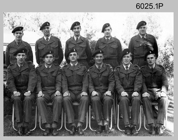 Bendigo Military Museum
Photograph - Royal Australian Survey Corps Course Photographs, c1960s, 1948
The first three photographs of Royal Australian Survey Corps training courses were probably taken in the 1960s. As they lack any annotation, the course title/type, trainee and instructor names, dates and locations are unknown. The courses were possibly conducted at the Army Survey Regiment at Fortuna, Bendigo; or the School of Military Survey either at Balcombe Victoria; or Bonegilla, Victoria. The fourth photograph is annotated with the course title and date, however the course type, trainee and instructor names and location are unknown.This is a set of photographs of Royal Australian Survey Corps courses from the 1960s and 1948. All four photographs were printed on photographic paper and are part of the Army Survey Regiment’s Collection. The photographs were scanned at 300 dpi. .1) Photo, black & white RASvy course trainees c1960s .2) Photo, black & white RASvy course trainees and instructors c1960s .3) Photo, black & white RASvy course trainees c1960s .4) Photo, black & white RASvy 1/48 Basic Course trainees 1948.1) to .3) no annotation .4) “1/48 Basic Course” written on backroyal australian survey corps, rasvy, army survey regiment, army svy regt, fortuna, asr -
Glenelg Shire Council Cultural Collection
Photograph - Photograph - Aerial Photo railway line between Heywood and Rennick, 03/05/1952
Victorian Railways aerial survey record print of the railway line between Heywood and Rennick (S.A. border) Black and white, white vertical strip on imageFront: 'to Rennick, Heywood from Melbourn' in the whites strip Back: 'Heywood - Rennick 21078 - 19369 235m 70c Heywood' - all black ink. Purple VR aerial survey stamp. '3 May 1952' - black stamp