Showing 3052 items
matching pink
-
 Melbourne Tram Museum
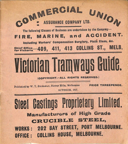
Ephemera, "Victorian Tramways Guide - October 1917", Oct. 1917
Timetable - 36 pages, printed on off-white paper, cover printed on pink paper, centre stapled titled "Victorian Tramways Guide" for October 1917. Details the timetables for the Tramway Board, Northcote Council, PMTT, NMETL, HTT, MBCTT and the VR Brighton line. Gives details of fares, routes, signs, first and last cars. Middle page - has a map and details of a Round trip and shows other lines and change points. Foldout map included on the inside rear cover, showing tramways, railways and rivers. Has many advertisements for the re-election of Sir Frank Madden (he was not re-elected - see http://www.parliament.vic.gov.au/re-member/details/569-madden-frank - accessed 30-12-2016). Polling day 15/11/1917. Has adverts for: Commercial Union Steel Castings Proprietary Limited Myer's Country of Bourke Permanent Building and Investment Society Prohibition - Canada, USA Royal Insurance Company Australian Ladies Commercial College Incley Frederick Collis Tramways Advertising Co. Stott's Business College Chambers and Seymour W. M Richards Huttons Ham Sterling Preparationstrams, tramways, timetables, melbourne, nmetl, vr, cable trams, htt, pmtt, map, advertising -
 Melbourne Tram Museum
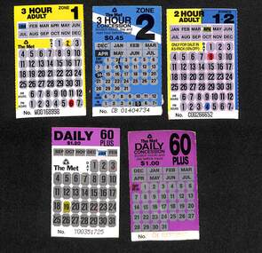
Ephemera - Ticket/s, Metropolitan Transit Authority (MTA), Set of five Scratch type tickets, 1989 and 1990
Set of five Scratch type tickets, with black printing on yellow / blue printed card or pink card and areas where a person could scratch out the month and day of the month areas to validate the ticket. Has the number on the base of the ticket. .1 - 3 hour adult, zone 1, has been scratched for Jan 2, 6 pm - W00168998 .2 - 3 hour zone 2 concession, used April 14 at 5pm, CB 01404734, expired 31/7/1990 .3 - 2 hour adult zone 1+2, used 8 April at 4pm, C00266652 .4 - Daily 60 plus, Jan 28, expired Jan 1991, Y00351725 .5 - Daily Concession 60 plus, unused, for 1989/90. CN03338507 On the rear of three are the conditions of travel for both types of tickets with information about the ticket type, The Met logos, Transport Information and Transit Patrol telephone numbers. The other two have similar information, with a statement that "The Met supports Olympics for Melbourne 1996" with the Olympics logo. See also Reg Item Nos. 574, 1069 and 979, 1661 for other examples.trams, tramways, the met, scratch tickets, olympics -
 Bendigo Historical Society Inc.
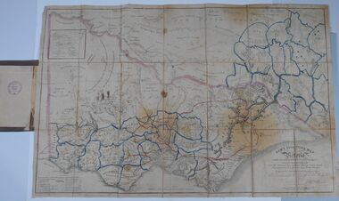
Document - HARRIS COLLECTION: HAMS SQUATTING MAP OF VICTORIA, PORT PHILLIP DISTRICT, NSW
Thomas Ham was a cartographer, engraver, lithographer and publisher in Victoria and Queensland. He compiled and printed several editions of his squatting map, beginning with A map of Australia Felix in 1847 and changing its title to Ham's squatting map of Victoria in 1851. The 1851 edition was accompanied by a key listing the names of all the squatters within squatting districts and counties. Later editions show the existing counties, but some areas of Gippsland and the Australian Alps are still described as 'unsurveyed country'. (State Library Victoria https://www.slv.vic.gov.au/squatting-map-victoria)Folding map enclosed in burgundy cover. Map backed by cloth and bound. Rare, early map of Victoria and neighbouring Port Phillip District of New South Wales. Written on bottom RH corner of map: Ham's Squatting Map of Victoria ( Port Phillip District, New South Wales ) carefully corrected to this date from the Colonial Government Surveys, Crown Lands, Commissioners & Explorers Maps, Private Surveys & c. Respectfully inscribed (with permission ) to His Excellency Sir Chas A. Fitz-Roy Knt, Governor of New South Wales &c &c by his Obedient Servant, The Compiler, 1851. Compiled, engraved and published by Thomas Ham, Melbourne. Proposed and original boundary ( in legend) have been coloured in in blue and pink ink ( later addition ?) Number on map show 'reference to proprietor's Printed on back of map ' J.G. AD 1852, with two cross hatched decorations and two hearts entwined. On other back panel in pencil enclosed in a drawn frame ' G.S.H., 1889, Axedale' (George Harris, Axedale, belongs in Harris Collection) Stamped in purple ink 'Royal Historical Society of Victoria, Bendigo Branch. Written 1959, 53.map, victoria, squatting map -
 Eltham District Historical Society Inc
Document - Folder, Partington family
Charles Partington married Ellen Whatmough; they and their children, Robert and James, came to Australia in 1857 because Ellen's brother, Robert Whatmough, had come here in 1841. Whatmough was Melbourne's first lamplighter while also working in John Batman's Spencer Street orchard; he moved in 1842 to establish an orchard in Greensborough. Both Partington boys died soon after the family arrived at Greensborough but later two daughters were born, Prudina and Maria, and five sons, including William . On arrival Charles Partington began work for Mr Flintoff at Black Hills and was later toll keeper on what is now Watsonia Road. He was later a successful orchardist. William Partington married Annie-May Medhurst, daughter of David Medhurst and Martha Ruston, daughter of Peter Ruston who had settled in Greensborough in the 1850s after working for Mr Hooper in Darebin Creek, then moved to Panton Hill in 1866 working as a carrier. The Rustons had six children, including Martha and James. Martha married David Medhurst in 1882 who was the son of David Medhurst and Charity Jane Pink. After David's death, Charity Jane married George Wescott. David and Martha Medhurst had eight children, including Annie May. They bought land in Main Street, Greensborough and set up as a greengrocer. William and Annie-May Partington's family home, Willis Vale, purchased from Mr Meagher by William's father, Charles; it was built by Meagher in 1839 but destroyed by vandals in 1966 after being compulsory purchased for parkland now called Partington's Flat. Their children were Eva, Grace, Alan, Jessie, and Jack. They attended Greensborough Primary School. Alan married Wyn. Contents Newspaper article: "Link with the past", Diamond Valley News, 21 February 1984. Alan Partington's research on Robert Whatmough, early settler in Greensborough, and his brother-in-law Charles Partington. Newspaper article: "How early families linked up", Diamond Valley News, 28 February 1984. Alan Partington's research into the Ruston and Medhurst families. Newspaper article: "Old days recalled", Diamond Valley News, 13 March 1984. Alan Partington's research in the Partington family.Newspaper clippings, A4 photocopies, etcalan partington, robert whatmough, watmough park greensborough, robert partington, james partington, elen partington nee whatmough, road tolls watsonia road, prudina partington, maria partington, william partington, willis vale, partington's flat greensborugh, mr meagher of greensborough, apollo parkways estate, charles partington, annie-may partington nee medhurst, david medhurst, martha medhurst (nee ruston), jack medhurst, peter ruston, hooper of darebin creek, greensborough hotel, james ruston, charity jane medhurst (nee pink), main street greensborough, eva partington, grace partington, jessie partington, jack partington, orchards in plenty river area, greensborough primary school, wyn partington, flintoff of black hills -
 Warrnambool and District Historical Society Inc.
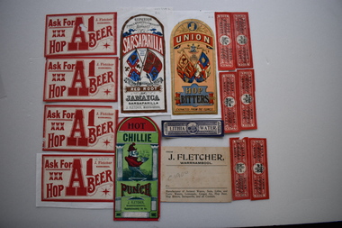
17 labels, J Fletcher, Early 20th century
In 1888 it was reported in "Victoria and its Metropolis" that John Fletcher carried on the business of a manufacturer of aerated waters, cordials, hop bitters, etc. in Warrnambool, and traded throughout the Western District. The establishment was started by a Mr. J. Davis with whom Mr. Fletcher was connected from its commencement, and whom he succeeded in 1885. His business continued until 1930. The Warrnambool and District Historical Society has a collection of bottles used by John Fletcher to contain his products. These labels are significant as John Fletcher was a most successful manufacturer of cordials and aerated waters in Warrnambool in the late 1800s and early 1900s .1 Buff coloured rectangular card label with black text. 2 Rectangular label with curved top adhered to a piece of white paper. It is coloured red, blue black and gold and features two standards and text. .3 Rectangular label with curved top adhered to the reverse of .2. It is coloured red and green and features a sketch of Punch carrying a bowl of a steaming substance and text .4 Rectangular label with curved top adhered to a piece of white paper. It is coloured red, apricot, dark and light blue, gold and black. It features the linked initials JF, two standards a trade mark and text .5 Rectangular label with curved top adhered to the reverse of .4 It is coloured red, blue, green, black and gold. It features two standards and text. .6 Identical to .3 but not adhered to paper .7,.8, .9 .10 White rectangular labels with red text. .9 has a damaged corner. .10 is adhered to a piece of white paper. .11,.12,.13,.14,.15..16 Red rectangular labels with black text and a coat of arms. .13 is adhered to a piece of pink card, .17 Blue rectangular label with text and a coat of arms .1 FROM J. FLETCHER, WARRNAMBOOL Manufacturer of Aerated Waters, Soda, Lithia and Tonic Waters, Lemonade, Ginger Ale, Hop beer, Hop Bitters, Sarsaparilla and all Cordials .2 SUPERIOR CONCENTATED COMPOUND EXTRACT OF SARSAPARILLA PREPARED FROM THE BEST RED ROOT OF JAMAICA SARSAPARILLA J. FLETCHER,WARRNAMBOOL .3 HOT CHILLIE PUNCH J. FLETCHER WARRNAMBOOL Approximately 26 Oz. .4 UNION TRADE MARK JOHN FLETCHER WARRNAMBOOL HOP BITTERS EXTRACTED FROM THE FLOWER .5 J FLETCHER WARRNAMBOOL SUPERIOR GREEN COLOURED WITH BURNT SUGAR GINGER CORDIAL .6 Identical to .3 .7,.8,.9,.10 ASK FOR XXX HOP A1 BEER J FLETCHER WARRNAMBOOL .11,.12,.13.14,.15.16 SODA WATER J Fletcher .17 LITHIA WATER J FLETCHER WARRNAMBOOL john fletcher, warnambool, cordials -
 Bendigo Historical Society Inc.
Document - AILEEN AND JOHN ELLISON COLLECTION: AXEDALE SPORTS ASSOCIATION SPORTS MEETING 1962
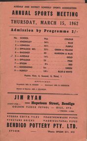
Axedale and District Schools' Sports Association. Annual Sports Meeting. Thursday, March 15, 1962. Admission by Programme 2/- Schools: No.1 Knowsley - Handicap: 26 1/2 - Colour: Blue No.2 Longlea - Handicap 26 1/2 - Colour: Purple No. 3 Eppalock Res. - Handicap: 22 1/2 - Colour: Green and Yellow No.4 Bagshot - Handicap: 25 - Colour: Maroon and Blue No. 5 Axedale - Handicap: 14 1/2 - Colour Gold No. 6 Eppalock - Handicap: 25 - Colour: Pink No.7 Epsom - Handicap: 8 1/2 - Colour: Red No.8 Goornong - Handicap: Scratch - Colour: Green No.9 Huntly - Handicap 18 1/2 - Colour: Blue and White Points: First: 5 - Second: 3 - Third: 1 Officials: President: Mr. H. Green, Secretary: Mr. D. Derrick, Master of Sports: Mr. J. Ellison Sponsors: Bendigo Pottery, Harold G. Ross, Axedale Service Station, E. C. & K. Fowles, The golden drive-in theatre, A. Brown, Every's, Wright's sports store. On the inside all the name of the boys and girls taking part in the various competitions.program, sporting event, axedale annual sports meeting -
 Ballarat Tramway Museum
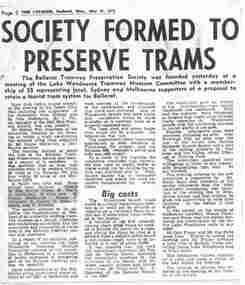
Newspaper, The Courier Ballarat, "Society formed to Preserve Trams", "Three stage plan for phasing out of trams", 14/07/1971 12:00:00 AM
Yields information about the formation of the BTPS in 1971 and some of the people who attended meetings etc. and about the closure of the Ballarat tramway system.Two Newspaper clippings pasted onto a single sheet of paper with two Punch holes on the left hand side. First clipping from The Courier, Ballarat, Monday, 31/5/1971, titled "Society formed to Preserve Trams" (newspaper date, with page 2), about the formation the previous day of the BTPS at a meeting of the Lake Wendouree Tramway Museum Committee with a membership of 55 people to retain a tourist tram system for Ballarat. Gives names of the elected office bearer, details of proposals, some costs, alternative sites and that a tram was chartered before the meeting. 1071.1 - photocopy of the article added 24/1/2008. Has the names of those elected highlighted in pink ink. Second cutting dated "14/7/71" from the Courier titled "Three stage plan for phasing out of trams" of the three stage plan for phasing out of the trams in Ballarat. The plan was announced by Transport Regulation Board the previous day. August 23 - Drummond St North and Victoria St., Sept. 6 for Gardens via Sturt St and Mt Pleasant and Sept 20 for Lydiard St. North and Sebastopol. 1071.2 - as above, original clipping, donated by Dave Macartney, added 10/9/2013In red ink in upper right hand corner of second cutting, "14/7/71" Has numerous pencil and pen marking from previous use, possibly at Ronaldson and Tippet where the donor worked.trams, tramways, closure, bus changeover, transport regulation board, tram services, btps -
 Ballarat Tramway Museum
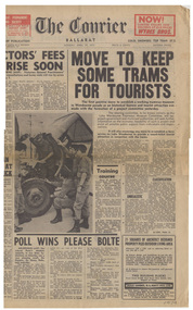
Newspaper, The Courier Ballarat, "Move to Keep some trams for Tourists", 19/04/1971 12:00:00 AM
Yields information about the formation of the BTPS in 1971 and some of the people who attended meetings etc.Newspaper clipping pasted onto a single sheet of paper with two Punch holes on the left hand side. Clipping from the Courier, Ballarat, Monday April 19, 1971, titled "Move to Keep some trams for Tourists" front page as it gives the price (of 6 cents) and number of pages (16), with the article about the first positive move to establish a working tramway museum in Wendouree Parade as a historical feature and tourist attraction was made with the formation of a project committee yesterday. Covers the formation of the Lake Wendouree Tramways Museum Committee, 50 people attending the meeting at Brown Hill, mentions Mr. Maurice Calnin, Mr. C. (Bill) Jessup, (spelt Jessop) and gives notes on proposals, other similar museum and potentials. Item was spread over two pages, second part on page 13. Both sections have been cut out and pasted adjacent to each other. 1074.1 - photocopy of the article added 24/1/2008. Has the names of those elected highlighted in pink ink. 1074.2 - front page of The Courier. Note the report on the Victorian elections on the lower part of the cover. Item added and image updated 10/9/2013.On rear has various pencil marks from former use at perhaps Donor's employer, Ronaldson and Tippet.trams, tramways, museum establishment, lake wendouree tramway, closure, btps -
 Kew Historical Society Inc
Plan, Melbourne & Metropolitan Board of Works. Borough of Kew Detail Plan No.1579, 1904
The Melbourne and Metropolitan Board of Works (MMBW) plans were produced from the 1890s to the 1950s. They were crucial to the design and development of Melbourne's sewerage and drainage system. The plans, at a scale of 40 feet to 1 inch (1:480), provide a detailed historical record of Melbourne streetscapes and environmental features. Each plan covers one or two street blocks (roughly six streets), showing details of buildings, including garden layouts and ownership boundaries, and features such as laneways, drains, bridges, parks, municipal boundaries and other prominent landmarks as they existed at the time each plan was produced. (Source: State Library of Victoria). This plan forms part of a large group of MMBW plans and maps that was donated to the Society by the Mr Poulter, City Engineer of the City of Kew in 1989. Within this collection, thirty-five hand-coloured plans, backed with linen, are of statewide significance as they include annotations that provide details of construction materials used in buildings in the first decade of the 20th century as well as additional information about land ownership and usage. The copies in the Public Record Office Victoria and the State Library of Victoria are monochrome versions which do not denote building materials so that the maps in this collection are invaluable and unique tools for researchers and heritage consultants. A number of the plans are not held in the collection of the State Library of Victoria so they have the additional attribute of rarity.Original survey plan, issued by the MMBW to a contractor with responsibility for constructing sewers in the area identified on the plan within the Borough of Kew. The plan was at some stage hand-coloured, possibly by the contractor, but more likely by officers working in the Engineering Department of the Borough and later Town, then City of Kew. The hand-coloured sections of buildings on the plan were used to denote masonry or brick constructions (pink), weatherboard constructions (yellow), and public buildings (grey). While MMBW Plan No.1579 does not include many buildings, those that it does show are significant to Kew’s history. These include the ‘Kew [Railway] Station’ in Denmark Street and the ‘Recreation Hall’ and rear courts off Wellington Street. The plan shows the outline of the Recreation Hall, constructed in 1880, at the rear of which is listed a bowling green, two tennis courts, a ‘skittle alley’ and a pavilion. When the Hall was first built, the Kew Cricket Club occupied an adjacent ground, however in 1885 this was acquired by the State Government as the future location of the Kew Railway Station. The Plan also shows a single oval at Xavier College. This oval was completed in 1883. One of the current ovals conforms to this oval’s original shape and position in the school grounds.melbourne and metropolitan board of works, detail plans, maps - borough of kew, mmbw 1579, cartography -
 Kew Historical Society Inc
Plan, Melbourne & Metropolitan Board of Works : Borough of Kew : Detail Plan No.1291, 1905
The Melbourne and Metropolitan Board of Works (MMBW) plans were produced from the 1890s to the 1950s. They were crucial to the design and development of Melbourne's sewerage and drainage system. The plans, at a scale of 40 feet to 1 inch (1:480), provide a detailed historical record of Melbourne streetscapes and environmental features. Each plan covers one or two street blocks (roughly six streets), showing details of buildings, including garden layouts and ownership boundaries, and features such as laneways, drains, bridges, parks, municipal boundaries and other prominent landmarks as they existed at the time each plan was produced. (Source: State Library of Victoria). This plan forms part of a large group of MMBW plans and maps that was donated to the Society by the Mr Poulter, City Engineer of the City of Kew in 1989. Within this collection, thirty-five hand-coloured plans, backed with linen, are of statewide significance as they include annotations that provide details of construction materials used in buildings in the first decade of the 20th century as well as additional information about land ownership and usage. The copies in the Public Record Office Victoria and the State Library of Victoria are monochrome versions which do not denote building materials so that the maps in this collection are invaluable and unique tools for researchers and heritage consultants. A number of the plans are not held in the collection of the State Library of Victoria so they have the additional attribute of rarity.Original survey plan, issued by the MMBW to a contractor with responsibility for constructing sewers in the area identified on the plan within the Borough of Kew. The plan was at some stage hand-coloured, possibly by the contractor, but more likely by officers working in the Engineering Department of the Borough and later Town, then City of Kew. The hand-coloured sections of buildings on the plan were used to denote masonry or brick constructions (pink), weatherboard constructions (yellow), and public buildings (grey). A detail plan of part of Studley Park bordered by the major streets of Hodgson Street, Stevenson Street and Studley Park Road. Included on the plan are a number of significant Studley Park mansions in existence at the beginning of the 20th century. The unnamed street shown in the middle of the plan is McEvoy Street. The most important house still extant is Campion House, formerly named Dalsraith [Dalswraith] and Glendalough, owned since the 1940s by the Society of Jesus. Campion House can be seen on the corner of Hodgson and Studley Park Road. Its stables at the rear of the block have now been incorporated into a contemporary residence. An interesting feature of the plan is the 1910 annotation by Ed Seitz, professional designing engineer. Is Seitz the contractor who modified the MMBW original?melbourne and metropolitan board of works, detail plans, mmbw 1291, cartography -
 Kew Historical Society Inc
Plan, Melbourne & Metropolitan Board of Works : Borough of Kew : Detail Plan No.1564, 1905
The Melbourne and Metropolitan Board of Works (MMBW) plans were produced from the 1890s to the 1950s. They were crucial to the design and development of Melbourne's sewerage and drainage system. The plans, at a scale of 40 feet to 1 inch (1:480), provide a detailed historical record of Melbourne streetscapes and environmental features. Each plan covers one or two street blocks (roughly six streets), showing details of buildings, including garden layouts and ownership boundaries, and features such as laneways, drains, bridges, parks, municipal boundaries and other prominent landmarks as they existed at the time each plan was produced. (Source: State Library of Victoria)This plan forms part of a large group of MMBW plans and maps that was donated to the Society by the Mr Poulter, City Engineer of the City of Kew in 1989. Within this collection, thirty-five hand-coloured plans, backed with linen, are of statewide significance as they include annotations that provide details of construction materials used in buildings in the first decade of the 20th century as well as additional information about land ownership and usage. The copies in the Public Record Office Victoria and the State Library of Victoria are monochrome versions which do not denote building materials so that the maps in this collection are invaluable and unique tools for researchers and heritage consultants. A number of the plans are not held in the collection of the State Library of Victoria so they have the additional attribute of rarity.Original survey plan, issued by the MMBW to a contractor with responsibility for constructing sewers in the area identified on the plan within the Borough of Kew. The plan was at some stage hand-coloured, possibly by the contractor, but more likely by officers working in the Engineering Department of the Borough and later Town, then City of Kew. The hand-coloured sections of buildings on the plan were used to denote masonry or brick constructions (pink), weatherboard constructions (yellow), and public buildings (grey). In 1905, when Plan No.1564 was printed, that part of Kew bordered by Brougham Place (now Daniell Place), Mount Street, Sackville Street and Ross Street was already the location of a number of large mansions. Here, subdivisions, at least at this stage, produced larger blocks than in Central Kew. Many of the houses on this plan are named: ‘Faybrook’, ‘Northumbria’, ‘Parkholm[e]’, ‘Dunboe’, ‘Katoomba’ and ‘Eschol’ fronting Sackville Street. Eschol was once the home of the manufacturer Robert Harrison, whose cordial factory in Spring and Argyle Streets Fitzroy are noted on the Victorian Heritage Register. ‘The Hawthorns’ on the corner of Brougham Place and Mount Street was the home of the medical practitioner Frank William Fay, who won the military cross and other honours for conspicuous gallantry and devotion to duty in World War 1.melbourne and metropolitan board of works, detail plans, mmbw 1564, cartography -
 Kew Historical Society Inc
Plan, Melbourne & Metropolitan Board of Works : Borough of Kew : Detail Plan No.1570, 1905
The Melbourne and Metropolitan Board of Works (MMBW) plans were produced from the 1890s to the 1950s. They were crucial to the design and development of Melbourne's sewerage and drainage system. The plans, at a scale of 40 feet to 1 inch (1:480), provide a detailed historical record of Melbourne streetscapes and environmental features. Each plan covers one or two street blocks (roughly six streets), showing details of buildings, including garden layouts and ownership boundaries, and features such as laneways, drains, bridges, parks, municipal boundaries and other prominent landmarks as they existed at the time each plan was produced. (Source: State Library of Victoria)This plan forms part of a large group of MMBW plans and maps that was donated to the Society by the Mr Poulter, City Engineer of the City of Kew in 1989. Within this collection, thirty-five hand-coloured plans, backed with linen, are of statewide significance as they include annotations that provide details of construction materials used in buildings in the first decade of the 20th century as well as additional information about land ownership and usage. The copies in the Public Record Office Victoria and the State Library of Victoria are monochrome versions which do not denote building materials so that the maps in this collection are invaluable and unique tools for researchers and heritage consultants. A number of the plans are not held in the collection of the State Library of Victoria so they have the additional attribute of rarity.Original survey plan, issued by the MMBW to a contractor with responsibility for constructing sewers in the area identified on the plan within the Borough of Kew. The plan was at some stage hand-coloured, possibly by the contractor, but more likely by officers working in the Engineering Department of the Borough and later Town, then City of Kew. The hand-coloured sections of buildings on the plan were used to denote masonry or brick constructions (pink), weatherboard constructions (yellow), and public buildings (grey). Plan No.1570 shows the layout of gardens and houses in Sackville Street, Davis Street, Wrixon Street, and Fitzwilliam Street in 1904. While Thomas Street is included on the map, at this stage no houses had been built. The plan identifies two named houses: ‘Fairview’ and ‘Kylemore’. Fairview is more fully delineated in Plan No.1563. Kylemore is one of the few houses in Kew designed by John Beswicke. The most notable owner of Kylemore was William Whitehead, who owned the house between 1895 and 1900. In 1894, Australian newspapers reported the marriage of Whitehead’s daughter to Dr. Gerald Eugene Cussen, the brother of Sir Leo Cussen, the Supreme Court Judge. The married couple was to live at ‘Wilton’ (now the Kew RSL) from 1911-15.melbourne and metropolitan board of works, detail plans, mmbw 1570, cartography -
 Kew Historical Society Inc
Plan, Melbourne & Metropolitan Board of Works : Borough of Kew : Detail Plan No.1572, 1905
The Melbourne and Metropolitan Board of Works (MMBW) plans were produced from the 1890s to the 1950s. They were crucial to the design and development of Melbourne's sewerage and drainage system. The plans, at a scale of 40 feet to 1 inch (1:480), provide a detailed historical record of Melbourne streetscapes and environmental features. Each plan covers one or two street blocks (roughly six streets), showing details of buildings, including garden layouts and ownership boundaries, and features such as laneways, drains, bridges, parks, municipal boundaries and other prominent landmarks as they existed at the time each plan was produced. (Source: State Library of Victoria)This plan forms part of a large group of MMBW plans and maps that was donated to the Society by the Mr Poulter, City Engineer of the City of Kew in 1989. Within this collection, thirty-five hand-coloured plans, backed with linen, are of statewide significance as they include annotations that provide details of construction materials used in buildings in the first decade of the 20th century as well as additional information about land ownership and usage. The copies in the Public Record Office Victoria and the State Library of Victoria are monochrome versions which do not denote building materials so that the maps in this collection are invaluable and unique tools for researchers and heritage consultants. A number of the plans are not held in the collection of the State Library of Victoria so they have the additional attribute of rarity.Original survey plan, issued by the MMBW to a contractor with responsibility for constructing sewers in the area identified on the plan within the Borough of Kew. The plan was at some stage hand-coloured, possibly by the contractor, but more likely by officers working in the Engineering Department of the Borough and later Town, then City of Kew. The hand-coloured sections of buildings on the plan were used to denote masonry or brick constructions (pink), weatherboard constructions (yellow), and public buildings (grey). Plan No. 1572 represents the built environment bordered by Barkers Road, Wrixon Street, Edgevale Road and Fitzwilliam Street. Other streets identified on the plan include Stansell Street. Plan 1572 shows that by 1903-05, there was only patchy development in this area of Kew, mainly on Edgevale Road and Fitzwilliam Street. Only two named houses are identified: the quaintly named ‘Tweed Cottage’, and ‘Mendip’. The earliest reference to Treed Cottage in Australian newspapers is to the death of Walter Thompson, aged 74 who was a resident there in 1885. His youngest daughter was to die there in 1908. Mendip to the north of Tweed Cottage was owned by Henry Thompson; he was to die in 1901; his wife in 1932. At this period of time, Malin Street and Clivedon Court did not extend to Barkers Road.melbourne and metropolitan board of works, detail plans, mmbw 1572, cartography -
Federation University Historical Collection
Pamphlet - Course Pamphlets, Ballarat Institute of Advanced Education Course Pamphlets, 1970s
Ballarat Institute of Advanced Education (BIAE) is a predecessor of Federation University .1 White A5 pamphlet for Business Studies with crest, black writing and matt gold square and lines .2 White A5 pamphlet for Art with crest, black writing and burnt orange square and lines .3 White A5 pamphlet for General Studies with crest., black writing and pink square and lines .4 White A5 pamphlet for Mechanical Engineering with crest, black writing and red square and lines .5 White A5 pamphlet for Mining Engineering with crest, black writing and grey square and lines .6 White A5 pamphlet for Electrical Engineering with crest, black writing yellow square and lines .7 White A5 pamphlet for Civil Engineering with crest, black writing and magenta square and lines .8 White A5 pamphlet for Applied Geology with crest, black writing and lemon yellow square and lines .9 White A5 pamphlet for Applied Chemistry with crest, black writing and green square and lines .10 White A5 pamphlet for Malting and Brewing (Post-Graduate) with crest, black writing and peach square and lines .11 White A5 pamphlet for Metallurgy with crest, black writing and blue square and lines .12 White A5 pamphlet for Appled Physics with crest, black writing and maroon square and lines course information, ballarat institute of advanced education, business studies, art, general studies, mechanical engineering, mining engineering, electrical engineering, civil engineering, applied geology, applied chemistry, malting & brewing, metallurgy, applied physics -
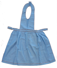
 Bendigo Historical Society Inc.
Clothing - AILEEN AND JOHN ELLISON COLLECTION: FLORAL DRESS
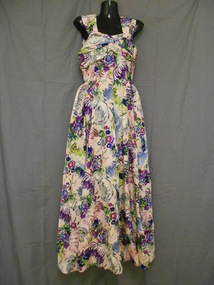
Pink, purple, green and grey floral patterned dress. Rayon fabric with smooth surface. Sleeveless bodice with wide shoulder straps. The shoulder straps widen from 6cm at the front across the shoulders to attach at either side of centre at 14cm. Back of the bodice is made of four straight pieces from waist to above bust line. The front of the bodice is made from three pieces with centre piece dipping. Narrow at front because gathered in to U shape at centre front at waist. Across the bust line are two pieces of fabric with horizontal folds to create fullness. The pieces are joined at centre front with a decorative knot of fabric. The bodice and shoulder straps are lined with cream coloured net. Two darts at front and two at back from waist. The full length skirt is made from two pieces at the front and the back is made from four pieces. Back of the bodice inverted at skirt. Back opening at centre back with 26cm metal zipper. Hook and eye above zipper. On either side of centre back are two folded pieces of gathered fabric attached at waistline to create the effect of a large bow with tails. Attached at the waist on each hip are two padded sections of fabric 39cm x 10cm, gathered at waist.costume, female daywear, dress -
 Kew Historical Society Inc
Plan, Melbourne & Metropolitan Board of Works : Borough of Kew : Detail Plan No.1296, 1904
The Melbourne and Metropolitan Board of Works (MMBW) plans were produced from the 1890s to the 1950s. They were crucial to the design and development of Melbourne's sewerage and drainage system. The plans, at a scale of 40 feet to 1 inch (1:480), provide a detailed historical record of Melbourne streetscapes and environmental features. Each plan covers one or two street blocks (roughly six streets), showing details of buildings, including garden layouts and ownership boundaries, and features such as laneways, drains, bridges, parks, municipal boundaries and other prominent landmarks as they existed at the time each plan was produced. (Source: State Library of Victoria)This plan forms part of a large group of MMBW plans and maps that was donated to the Society by the Mr Poulter, City Engineer of the City of Kew in 1989. Within this collection, thirty-five hand-coloured plans, backed with linen, are of statewide significance as they include annotations that provide details of construction materials used in buildings in the first decade of the 20th century as well as additional information about land ownership and usage. The copies in the Public Record Office Victoria and the State Library of Victoria are monochrome versions which do not denote building materials so that the maps in this collection are invaluable and unique tools for researchers and heritage consultants. A number of the plans are not held in the collection of the State Library of Victoria so they have the additional attribute of rarity.Original survey plan, issued by the MMBW to a contractor with responsibility for constructing sewers in the area identified on the plan within the Borough of Kew. The plan was at some stage hand-coloured, possibly by the contractor, but more likely by officers working in the Engineering Department of the Borough and later Town, then City of Kew. The hand-coloured sections of buildings on the plan were used to denote masonry or brick constructions (pink), weatherboard constructions (yellow), and public buildings (grey). This area was once known as O’Shaughnessy’s Paddock. O’Shaughnessy was the licensee of the Kew Hotel. The ‘Paddock’ or farm was for many years the closest farm to Melbourne. By 1903, when this plan was surveyed and lithographed, little of the farm remained. The area is dominated by a ‘clay hole’, on the site of the current Foley Reserve. It was used by Smart’s Brickyard from the 1880s until 1911, when the Council purchased it for a rubbish dump. It is notable as the site is one of the few industrial operations to have existed in Kew. By 1903, urban development was characterised by larger houses fronting Barkers Road and brick and weatherboard villas in Foley Street. Nearer the pit, weatherboard houses predominated. Foley Street bisected the triangular block and continued right to Denmark Street. At this stage, a house impeded the through road, only allowing access via a right of way to High Street.melbourne and metropolitan board of works, detail plans, mmbw 1296, cartography -
 Kew Historical Society Inc
Plan, Melbourne & Metropolitan Board of Works : Borough of Kew : Detail Plan No.1301, 1910
The Melbourne and Metropolitan Board of Works (MMBW) plans were produced from the 1890s to the 1950s. They were crucial to the design and development of Melbourne's sewerage and drainage system. The plans, at a scale of 40 feet to 1 inch (1:480), provide a detailed historical record of Melbourne streetscapes and environmental features. Each plan covers one or two street blocks (roughly six streets), showing details of buildings, including garden layouts and ownership boundaries, and features such as laneways, drains, bridges, parks, municipal boundaries and other prominent landmarks as they existed at the time each plan was produced. (Source: State Library of Victoria)This plan forms part of a large group of MMBW plans and maps that was donated to the Society by the Mr Poulter, City Engineer of the City of Kew in 1989. Within this collection, thirty-five hand-coloured plans, backed with linen, are of statewide significance as they include annotations that provide details of construction materials used in buildings in the first decade of the 20th century as well as additional information about land ownership and usage. The copies in the Public Record Office Victoria and the State Library of Victoria are monochrome versions which do not denote building materials so that the maps in this collection are invaluable and unique tools for researchers and heritage consultants. A number of the plans are not held in the collection of the State Library of Victoria so they have the additional attribute of rarity.Original survey plan, issued by the MMBW to a contractor with responsibility for constructing sewers in the area identified on the plan within the Borough of Kew. The plan was at some stage hand-coloured, possibly by the contractor, but more likely by officers working in the Engineering Department of the Borough and later Town, then City of Kew. The hand-coloured sections of buildings on the plan were used to denote masonry or brick constructions (pink), weatherboard constructions (yellow), and public buildings (grey). Throughout its history, the land in what is known today as Studley Ward of the City of Boroondara has been subject to continuing subdivision. This is evident in Plan 1301, where later hands have modified the original map to include streets created subsequent to the printing of the plan in 1904. Other annotations such as the ‘Reserved for Road Purposes’ beside the Yarra never eventuated. The plan continued to be modified to at least 1953, when a later hand noted that a particular site was ‘Property site P. McIntyre house’ in Swinton Avenue. Two significant houses in the area are outlined on the plan: ‘Swinton’ on the corner of the streets then named Effey and Maud Streets (now Swinton Avenue) and ‘Fairhaven’ [unnamed] in Stevenson Street. The gardens of the two David Syme owned mansions of ‘Blythswood’ and ‘Rockingham’, stretching down to the River Yarra, are also represented.melbourne and metropolitan board of works, detail plans, mmbw 1301, cartography -
 Federation University Historical Collection
Clothing - Textiles, Ruth McGannon, Needlework, c 1950-70s
These items were made as samplers either at school or most likely college. They are samples of embroidery stitches, seam types and sewing and knitting techniques.Nos 1-16 are group of samplers made from cotton lawn, cotton with sateen weave and flannel and made by Ruth McGannon. No 17 is a pair of gloves made by Margaret Russell. .1) A small square of yellow lawn with three horizontal rows in blue thread and three vertical rows in red thread of running stitch each 3.5 centimeters apart. The edges are frayed to 1.2 centimeters. .2) A larger rectangle of yellow lawn with three horizontal rows 7.8 centimeters apart and three vertical rows 10 centimeters apart of long stitch, stitched in blue thread. The edges are frayed to 2 centimeters. .3) A small square of yellow lawn with three horizontal rows and three vertical rows of blue thread of running stitch, each 1.9 centimeters apart. The edges are frayed to 1.5 centimeters. .4) A larger rectangle of yellow lawn with three horizontal rows 9 centimeters apart and three vertical rows 11.2 centimeters apart of running stitch, stitched in red thread. The edges are hemmed with two rows of long stitch .5 centimeter apart with a loose blue thread of laced running stitch weaving in and out of the red long stitch. .5) A rectangle of hemmed yellow lawn with a pocket formed at each end. Two rows of long stitch in red thread hem the edges with a blue thread stitched between each red stitch. The pockets are formed by turning back the edges and stitching them down in brown thread. R.M. is embroidered in brown chain stitch on the right side. .6) A rectangle of hemmed blue lawn the same as the previous piece but with five rows of back stitch in yellow and orange thread creating a pattern. .7) A rectangle of blue lawn with the top and bottom edges hemmed with two rows of long stitch close together in yellow and orange. The other two edge are frayed to 2.5 centimeters and has four rows of long stitch .7 centimeter apart in yellow and orange thread. .8) A blue lawn bag with two packets was made by hemming a rectangle of fabric on three sides in long stitch with orange thread, then yellow thread between the stitches. The fourth side is hemmed in hemming stitch in yellow thread with blanket stitch in yellow thread along the edge. This edge is folded up by one third to create a pocket. The edges on either side are stitched together. A row of chain stitch in orange thread is stitched down the middle to create two pockets. A tape is stitched to either side at the top and this is folded over the pocket. .9) A cream cotton with sateen weave rectangle is hemmed with a double row of orange thread in long stitch. On both sides is embroidery in orange and yellow thread. .10) A yellow cotton with sateen weave baby's bib is made from a rectangle of fabric with a semi circle cut out of the top. The edges are turned and hemmed with a narrower turning on the neck. A tape is stitched at either side of the neck. On the front is embroidered a train in blue and yellow threads. .11) A yellow lawn embroidery sampler using blue and brown thread shows long stitch, stem stitch, herringbone stitch, chain stitch, fly stitch, lazy daisy stitch, cross stitch and satin stitch. It is hemmed using drawn thread work and the bottom is scalloped and finished in blanket stitch. .12) A pink lawn embroidery sampler with green thread shows herringbone stitch, stem stitch, running stitch, chain stitch, cross stitch, lazy daisy stitch, fly stitch, feather stitch, satin stitch and back stitch. The bottom is scalloped and finished in buttonhole stitched. The other three edges are hemmed using drawn thread work. .13) A small cream flannel square with two smaller squares are stitched together down the middle in decreasing sizes using chain stitch. The largest piece is hemmed using both herringbone and a decorative blanket stitch. It also has a run and fell seam on the opposite side using both running and herringbone stitches. A row of feather stitch is on either side of the seam. The two smaller squares are frayed on the edges. .14) A cream rectangular flannel sampler has two seams along the length. One is a run and fell seam using running and herringbone stitches and the other is an open seam using running stitch and both edges are stitched down with herringbone stitch. The two shorter edges are bound and the longer edges have a tape which is stitched down to neaten the edges. On the right side are two rows of feather stitch. .15) This blue lawn apron has a rectangular gathered skirt which is attached to a waistband and in turn attached to a bib front which goes over the head. The bib and skirt sides are hemmed using decorative blanket stitch in pink and dark blue thread. The skirt hem and both sides of the waistband are stitched in two rows of herringbone in pink and dark blue thread. .16) This pale pink lawn child's shirt has french seam side seams, a waist band to which the shirt is attached using slight gathering. The sleeves have cuffs. There is a front facing and a collar and there is a small pocket in the left hand breast. .17) These yellow knitted gloves are made using plain stitch for the hand and rib for the wrist.Written on paper and stitched on to a couple of items - Ruth McGannon V.3 - 312 Written on paper and stitched to the gloves - Margaret Russell x No2embroidery, sampler, gloves, stitches, sewing, knitting, apron, costume, needlework, dressmaking, textiles -
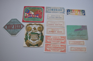 Warrnambool and District Historical Society Inc.
13 labels, Rowley
In 1868 John Rowley opened a soda water manufactory attached to the Corio Brewery and this was renamed the Warrnambool Steam Aerated Works in 1872. By the 1880s his factory at the corner of Timor and Banyan Streets was occupying half an acre of land , employing 13 people and manufacturing 20 varieties of drinks. Following Rowley's death the factory and plant was sold but the cordial manufacturing business continued for some years. These labels are of great significance as John Rowley was a dominant name in the cordial making business in Warrnambool..1 Rectangular , red, green, blue and white label featuring text, two flags with lions, a sailing ship, a sheep and a sheaf of wheat. There is a scroll with text. A white decorative border surrounds the label. It is adhered to a piece of red thin cardboard. .2 Irregular shaped label with gold and green decorations on a white background and text. The decorative pieces include grapes, vine leaves, flowers, the profile of a wolf, and two medallions with the coat of arms of Warrnambool There are two scrolls with text The label is adhered to a piece of white card. .5 Rectangular Multi coloured label with text adhered to a piece of white paper .4 Rectangular green card with text .3 Hexagonal grey/green label with black and red text and decorative black dotted curls mounted on white paper .6 White rectangular label with blue text and decorative surround of leaves and flowers. It has damage to three corners. .7 White label with blue text and decorative border adhered to white paper. .8 Pale pink rectangular card label with rose coloured text and a decorative border. .9 Cream rectangular label with red text and decorative border adhered to a piece of white paper 10.1, 10.2 Cream rectangular labels with red text. .2 is adhered to white paper. 11.1, 11.2 Cream rectangular labels with red text and borders adhered to white paper..1 ROWLEY'S STANDARD CLOVES WARRNAMBOOL COLOURED WITH BURNT SUGAR .2 Warrnambool NULLI SECUNDUS BY THESE WE FLOURISH STANDARD ORANGE BITTERS J.S.ROWLEY .3 STANDARD HOP BEER J.S. ROWLEY AERATED WATERS & CORDIAL MANUFACTURER WARRNAMBOOL .4 Rowley's SPARKLING Ginger Champagne NON ALCOHOLIC AND INVIGORATING .5 WARRNAMBOOL J.S.ROWLEY'S GINGERALE. TO HIS EXCELLENCY LORD BRASSEY K.G.B. .6 ROWLEY'S LEMONADE MANUFACTURED WITH THOROUGHLY FILTERED RAIN WATER WARRNAMBOOL .7 ROWLEY'S LITHIA WATER .8 ROWLEY'S TONIC WATER .9 ROWLEY'S GINGER BEER .10.1 ,10.2 ROWLEY'S KOLA CHAMPAGNE A Most Highly Refreshing and Excellent Beverage. Its properties are unequalled for preventing fatigue. .11 J.S ROWLEY, MANUFACTURER WARRNAMBOOL & HAMILTON CONTENTS APPROXIMATELY 25 OZ. THIS CORDIAL DOES NOT CONTAIN ANY PRESERVATIVE .2 Warrnambool NULLI SECUNDUS BY THESE WE FLOURISH STANDARD ORANGE BITTERS J.S ROWLEY john rowley, cordial manufacture -
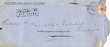 Bendigo Historical Society Inc.
Document - CONNELLY, TATCHELL, DUNLOP COLLECTION: DOCUMENT
Seven unclaimed letters from Connelly & Tatchell, Solicitors, Sandhurst and Connelly, Tatchell & Dunlop, Barristers & Solicitors, Bendigo. Letters in the name of - J. McCarthy Senr., Axe Creek, re fencing land at Axe Creek, dated Sept 26 1891; Mr. Richards, Miner, New Chum, dated 16 Feby 1888, re perusing summons for assault and taking instructions for defence; Mr. James Baker, High Street, Sandhurst, re Attending Mr. Hopkins with respect to contract, dated 3 Nov 1886; Herbert Stokes Fernshaw, re Coffee Palace, St. Kilda, re appearance, letters and advice, dated Sept 11, 14, 16, 28, 30, Oct 5 and 6 1891; Mrs. A. Williams, c/ Mrs. Pinder, Carpenter St. Bendigo re Divorce, dated Dec 1900; Mr. Joseph Metcalf, Mining Manager, Gapsted, re Mortgage, dated 1901, has pink Return to Sender ink stamp; Mr. Gardner, Breen Street, Quarry Hill, re Opie, dated Nov 1901. Four letters have mauve Victoria Two Pence Stamp Duty stamps, one has no stamp, one has a red Victoria One Penny Stamp Duty stamp and one has a lighter red Victoria One Penny Postage stamp.business, legal, connelly & tatchell, connelly & tatchell collection - document, connelly tatchell & dunlop, j mccarthy senr, mr gardner, joseph metcalf, mrs a williams, mrs pinder, herbert stokes fernshaw, james baker, mr hopkins, mr richards -
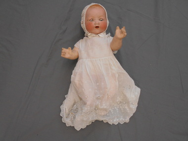 Bendigo Historical Society Inc.
Leisure object - ARMAND MARSEILLE DOLL ARMAND MARSEILLE DOLL. MY DREAM BABY DOLL AM 351, 1926
Marseille My Dream Baby doll, 8-22" tall, bisque head, lightly painted hair, painted or sleep eyes, doll mold 351 has an open mouth with two upper teeth, cloth body with bisque or composition hands or composition jointed body, came as either a white doll or black doll. Doll face shown is a socket bisque head with sleep eyes on a composition jointed body. Armand Marseille of Sonneberg and Koppelsdorf, Thüringia, Germany was one of the worlds largest and best known bisque doll head manufacturers. The founder was born in 1856 in St. Petersburg, Russia the son of an architect and immigrated to Germany with his family after 1860. In 1884 he bought the toy factory of Mathias Lambert in Sonneberg and in 1885 acquired the porcelain factory of Liebermann & Wegescher in Koppelsdorf . . and his empire in the doll world began. Made 1924 - 1930 and later Bisque heads made by AM represented a new born infant. They came in white, brown and black versions. Mold 351 with open mouth and two lower teeth. The bodies were either cloth or composition AM doll. China haed, sleep eyes, painted lashes, two bottom teeth. Doll’s head has been repaired (badly) Composition body in good condition Embroidered lawn dress with pink embroidery. Appears to be original clothes Doll purchased from Harrods in London in 1926 -
 Ballarat Tramway Museum
document - Correspondence, Electric Supply Co. of Vic (ESCo), Aug. 1929
Set of three letters between Mr. P. J. Pringle of ESCo Ballarat and Mr. D. Murdoch, General Manager of the TB Melbourne regarding rates of pay for conductors and drivers. 1977.1 - Letter from Mr. Pringle to Mr. Murdoch dated 27/8/1929, received by TB 28/8/1929, thanking for information regarding rates of pay. On ESCo letterhead. Has file number "22/1/2" in pencil in top right hand corner. Has been folded into 6. Damaged on right and bottom edges - folded and creased. 1977.2 - Carbon copy on pink paper from Mr. Murdoch to Mr. Pringle, dated 21/8/1929, advising the fares for conductors and drivers in 1923 and 1929 on a per day basis. Damaged along bottom edge. Has file number "22/1/2" in pencil in top right hand corner. 1977.3 - Letter from Mr. Pringle to Mr. Murdoch dated 19/8/1929, received by TB 20/8/1929, requesting copy of Tramway Agreement, and margins for skill paid to conductors. Has been folded into 6. Has pencil figures in the bottom left hand corner of the rates of pay. Minor damage along bottom edge. All have pin holes in the top left hand corner. tram, trams, esco, mmtb, wages, drivers, conductors -
 Ballarat Tramway Museum
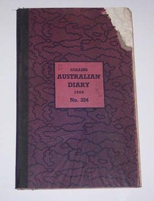
Administrative record - Log book, Diary, Collins Bros, 1959
Yields information about the track maintenance activities of the track gang in Ballarat, the work they did, notes, names and other information.Collins Australian Diary, 1960, No. 324 printed by Collins Bros, pattered dark red cover with green cloth binding on cover, card covers, sewn sections with ruled sheets providing a diary for 1960, one week per double page. Has "useful information" sheets at from the diary. Used by the SEC Ballarat track gang to record their daily work, leave, welding, track cleaning, truck driver etc Rear pages - has notes on materials used, costs, scrubber use and hours, and length of track On the2nd last page is a list of Track gang and addresses for 1960. H. Dowie S. Eaton W. Newell E. Lakey J. Armstrong J. Naus - welder C. Edwards A. W. Cunningham H. Lancaster H. Smith G. McQuinn E. Fish W. Holder L. Marks D. Wiseman - welder Cash account sheets for April - September - weekly hours of workers. Loose contents 1. - by rates of postage sheet - notes on work on rear of time sheets 2 - by rain chart - application for leave form 3 - by engagements - for July - part of a 1960 income tax return form - with some calculations on it. 4 - 19/12/1960 - notes re work 5 - Memoranda sheet - notes on pink time sheet - re work requirements? 6 - Inside rear cover - a sheet with names and SEC leave due notes. tram, trams, sec, ballarat, depot, trackwork, rails, scrubber tram -
 Ballarat Tramway Museum
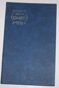
Administrative record - Log book, Diary, Collins Bros, 1970
Yields information about the track maintenance activities of the track gang in Ballarat, the work they did, notes, names and other information.Collins Australian Diary, No. 324 printed by Collins Bros, dark blue card covers, sewn sections with ruled sheets providing a diary for 1971, one week per double page. Has "useful information" sheets at from the diary. Used by the SEC Ballarat track gang to record their daily work, leave, welding, track cleaning, truck driver etc. Names of gang often mentioned in the diary undertaking specific jobs and when on leave. Last day work recorded - 24/9/1072. Loose contents Inside front cover Workshop requisition to fill pot holes and note re rail requirements for Daylesford and Hamilton. Clip to page with metal paper clip. 29/8/1971 - note re account numbers and on rear of a pink requisition form - work list for gang. 12/9/1971 - Workshop Requisition form - green dated 6/5/1971 Inside rear cover Circular for a Male Cleaner in Traralgon Workshop Requisition for work at the Zone substation - Ballarat South Circular to authorised drivers re used of defective vehicles. Has W. Vermeend name typed in top left hand corner. SEC Long Service Regulations circular - has name D.Wiseman handwritten in top right hand corner. 5 sheets of blue carbon paper.tram, trams, sec, ballarat, depot, trackwork -
 Bendigo Historical Society Inc.
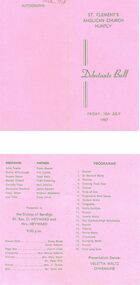
Document - PETER ELLIS COLLECTION: DEBUTANTE BALL, 10th July, 1987
Pink coloured card Green writing St. Clement's Anglican Church Huntly Debutante Ball Friday, 10th July 1987. Debutantes Partners Julie Fowler Frank Munro Donna McCullough Tim Carlile Angela Nolan Peter Kelly Mandy O'Neill Todd Pickering Danielle Price Karl Jenkins Maryanne Stratford Jamie Bennett Vicky Tehan Andrew Middleton Lisa Tiller Craig Jarvis Presented to the Bishop of Bendigo Rt. Rev. O. Heyward and Mrs. Heyward 9.00 p.m. Flower girls Diana Bosse Genai Roberts Page boy Austin Jinks Chaperone Mrs. Denise Roberts Trainers Mrs. Mary Smith Mr. Peter Ellis Pianist Mrs. J. Grotto M.C. Mr. Colin Silk. Programme 1 Foxtrot 2 St. Bernard Waltz 3 Maxina 4 Evening Three Step 5 Foxtrot 6 Pride of Erin 7 Progressive Barn Dance 8 Modern Waltz 9 Tangoette 10 Waltz Cotillion 11 Foxtrot 12 Valetta Waltz 13 Gay Gordons/ High Schottische 14 Foxtrot 15 Alberts 16 Parma Waltz 17 Charmaine 18 Swinging Waltz 19 Foxtrot 20 Auld Lang Syne Presentation Dance: Veletta Waltz Charmaine. Autographs.person, individual, peter ellis oam -
 Kew Historical Society Inc
Plan, Melbourne & Metropolitan Board of Works : Borough of Kew : Detail Plan No.1576, 1904
The Melbourne and Metropolitan Board of Works (MMBW) plans were produced from the 1890s to the 1950s. They were crucial to the design and development of Melbourne's sewerage and drainage system. The plans, at a scale of 40 feet to 1 inch (1:480), provide a detailed historical record of Melbourne streetscapes and environmental features. Each plan covers one or two street blocks (roughly six streets), showing details of buildings, including garden layouts and ownership boundaries, and features such as laneways, drains, bridges, parks, municipal boundaries and other prominent landmarks as they existed at the time each plan was produced. (Source: State Library of Victoria)This plan forms part of a large group of MMBW plans and maps that was donated to the Society by the Mr Poulter, City Engineer of the City of Kew in 1989. Within this collection, thirty-five hand-coloured plans, backed with linen, are of statewide significance as they include annotations that provide details of construction materials used in buildings in the first decade of the 20th century as well as additional information about land ownership and usage. The copies in the Public Record Office Victoria and the State Library of Victoria are monochrome versions which do not denote building materials so that the maps in this collection are invaluable and unique tools for researchers and heritage consultants. A number of the plans are not held in the collection of the State Library of Victoria so they have the additional attribute of rarity.Original survey plan, issued by the MMBW to a contractor with responsibility for constructing sewers in the area identified on the plan within the Borough of Kew. The plan was at some stage hand-coloured, possibly by the contractor, but more likely by officers working in the Engineering Department of the Borough and later Town, then City of Kew. The hand-coloured sections of buildings on the plan were used to denote masonry or brick constructions (pink), weatherboard constructions (yellow), and public buildings (grey). Development in the 20th century has irreparably altered that part of Kew represented in this plan. In the block bounded by Cotham Road, Charles Street, Wellington Street and Gellibrand; just one house standing in 1903 remains. This block included two of the most historic houses in Kew: ‘Ordsall’ (later ‘Southesk’) and ‘Madford’ (previously ‘Elm Lodge’). Ordsall was the home of the second chairman of Kew, John Halfey. It contained some of the most significant interior murals in Kew, created for Halfey by artists working for Cullen & Co. It was demolished in 1960 to make way for the Kew Civic Centre. Elm Lodge had been built for William Siddeley in ca. 1864. Arthur Septimus King purchased it in 1874. The lower paddocks of Madford were sold in 1905 by his wife to the Borough of Kew and, after landscaping by George and Thomas Pockett, opened as the Alexandra Gardens in 1908. Elm Lodge/Madford was in 1922 to become St. Anthony’s Home for Little Children before its subsequent demolition in the 1980s.melbourne and metropolitan board of works, detail plans, maps - borough of kew, mmbw 1576, cartography -
 Kew Historical Society Inc
Plan, Melbourne & Metropolitan Board of Works : Borough of Kew : Detail Plan No.1581, 1904
The Melbourne and Metropolitan Board of Works (MMBW) plans were produced from the 1890s to the 1950s. They were crucial to the design and development of Melbourne's sewerage and drainage system. The plans, at a scale of 40 feet to 1 inch (1:480), provide a detailed historical record of Melbourne streetscapes and environmental features. Each plan covers one or two street blocks (roughly six streets), showing details of buildings, including garden layouts and ownership boundaries, and features such as laneways, drains, bridges, parks, municipal boundaries and other prominent landmarks as they existed at the time each plan was produced. (Source: State Library of Victoria)This plan forms part of a large group of MMBW plans and maps that was donated to the Society by the Mr Poulter, City Engineer of the City of Kew in 1989. Within this collection, thirty-five hand-coloured plans, backed with linen, are of statewide significance as they include annotations that provide details of construction materials used in buildings in the first decade of the 20th century as well as additional information about land ownership and usage. The copies in the Public Record Office Victoria and the State Library of Victoria are monochrome versions which do not denote building materials so that the maps in this collection are invaluable and unique tools for researchers and heritage consultants. A number of the plans are not held in the collection of the State Library of Victoria so they have the additional attribute of rarity.Original survey plan, issued by the MMBW to a contractor with responsibility for constructing sewers in the area identified on the plan within the Borough of Kew. The plan was at some stage hand-coloured, possibly by the contractor, but more likely by officers working in the Engineering Department of the Borough and later Town, then City of Kew. The hand-coloured sections of buildings on the plan were used to denote masonry or brick constructions (pink), weatherboard constructions (yellow), and public buildings (grey). The streets and built structures in this plan were surveyed in 1903 and released to contractors in 1904. In addition to the designation of building types by colour, the plan includes detailed descriptions of land use and ownership. While many buildings remain from this period, a number of the buildings represented have been demolished including the original Kew Town Hall, and the Congregational and Roman Catholic churches in Walpole Street. While the mansion ‘Illapa’ in Princess Street is still extant – now part of ‘Rylands’ – the neighbouring mansion ‘Elsmere’ was demolished some decades ago. Rivalling Illapa and Elsmere in size were two mansions in Walpole Street, one named on the plan as ‘Gnarlbine’. Over time, Kew Junction and the south side of High Street have been reconfigured and widened, so that the commercial buildings on the corner of Princess and High Street no longer exist. A surprising feature of this part of central Kew to the northwest of Kew Junction is the amount of vacant land. In a number of cases, this land is noted by the contractor as used for vegetable gardens.melbourne and metropolitan board of works, detail plans, maps - borough of kew, mmbw 1581, cartography -
 Kew Historical Society Inc
Plan, Melbourne and Metropolitan Board of Works, Melbourne & Metropolitan Board of Works : Borough of Kew : Detail Plan No.1294 & 1295, 1904
The Melbourne and Metropolitan Board of Works (MMBW) plans were produced from the 1890s to the 1950s. They were crucial to the design and development of Melbourne's sewerage and drainage system. The plans, at a scale of 40 feet to 1 inch (1:480), provide a detailed historical record of Melbourne streetscapes and environmental features. Each plan covers one or two street blocks (roughly six streets), showing details of buildings, including garden layouts and ownership boundaries, and features such as laneways, drains, bridges, parks, municipal boundaries and other prominent landmarks as they existed at the time each plan was produced. (Source: State Library of Victoria). This plan forms part of a large group of MMBW plans and maps that was donated to the Society by the Mr Poulter, City Engineer of the City of Kew in 1989. Within this collection, thirty-five hand-coloured plans, backed with linen, are of statewide significance as they include annotations that provide details of construction materials used in buildings in the first decade of the 20th century as well as additional information about land ownership and usage. The copies in the Public Record Office Victoria and the State Library of Victoria are monochrome versions which do not denote building materials so that the maps in this collection are invaluable and unique tools for researchers and heritage consultants. A number of the plans are not held in the collection of the State Library of Victoria so they have the additional attribute of rarity.Original survey plan, issued by the MMBW to a contractor with responsibility for constructing sewers in the area identified on the plan within the Borough of Kew. The plan was at some stage hand-coloured, possibly by the contractor, but more likely by officers working in the Engineering Department of the Borough and later Town, then City of Kew. The hand-coloured sections of buildings on the plan were used to denote masonry or brick constructions (pink), weatherboard constructions (yellow), and public buildings (grey).The streets and built structures in MMBW Detail Plan 1294 & 1295 were surveyed in 1903 and released to contractors in 1904. This plan is one of two in the collection where the lithographers amalgamated two separate plans. Both plans include sections of Studley Park. Dominating the south and west corners of Kew Junction are the Clifton and Kew Hotels. The Kew Hotel, owned by Patrick O’Shaughnessy was one of the oldest in Kew. MMBW plans were amended over time to take account of new subdivisions such as that which created Merrion Place. Of the four mansions shown in Studley Park Road, three remain – ‘Field Place’, the home of Frances Henty, ‘Leaghur’ and ‘Darley’. ‘Byram’ (later ‘Goathland’, then ‘Tara Hall’) was an architectural marvel. Designed in 1888 by E.G. Kilburn for the paper magnate George Ramsden, it was demolished in 1960. While an earlier sale of the southern section of Byram had created Tara Avenue in 1927, the demolition of the house in 1960 enabled the extension of Tara Avenue northward.melbourne and metropolitan board of works, detail plans, mmbw 1294, mmbw 1295, cartography -
 Kew Historical Society Inc
Plan, Melbourne & Metropolitan Board of Works : Borough of Kew : Detail Plan No.1297, 1904
The Melbourne and Metropolitan Board of Works (MMBW) plans were produced from the 1890s to the 1950s. They were crucial to the design and development of Melbourne's sewerage and drainage system. The plans, at a scale of 40 feet to 1 inch (1:480), provide a detailed historical record of Melbourne streetscapes and environmental features. Each plan covers one or two street blocks (roughly six streets), showing details of buildings, including garden layouts and ownership boundaries, and features such as laneways, drains, bridges, parks, municipal boundaries and other prominent landmarks as they existed at the time each plan was produced. (Source: State Library of Victoria)This plan forms part of a large group of MMBW plans and maps that was donated to the Society by the Mr Poulter, City Engineer of the City of Kew in 1989. Within this collection, thirty-five hand-coloured plans, backed with linen, are of statewide significance as they include annotations that provide details of construction materials used in buildings in the first decade of the 20th century as well as additional information about land ownership and usage. The copies in the Public Record Office Victoria and the State Library of Victoria are monochrome versions which do not denote building materials so that the maps in this collection are invaluable and unique tools for researchers and heritage consultants. A number of the plans are not held in the collection of the State Library of Victoria so they have the additional attribute of rarity.Original survey plan, issued by the MMBW to a sewage contractor with responsibility for constructing sewers in the area identified on the plan within the Borough of Kew. The plan was at some stage hand-coloured, possibly by the contractor, but more likely by officers working in the Engineering Department of the Borough and later Town, then City of Kew. The hand-coloured sections of buildings on the plan were used to denote masonry or brick constructions (pink), weatherboard constructions (yellow), and public buildings (grey). This plan of Kew encompasses the area bounded by Barkers Road, High Street and Stevenson Street. Because of the angle created by High Street, a number of houses on the northern side of High Street are shown. The area is dominated by one of the great original landholdings in Kew, described here as the ‘Findon Paddock’. ‘Findon’, the house from which the name of the paddock was taken fronts Stevenson Street and was clearly a rambling structure. The best-known occupant of Findon was Henry ‘Money Miller’ who bought the house in 1871. Miller was a member of Victoria’s first parliament and assisted in the framing of its constitution. Findon was to be subdivided as early as 1912, when the Findon Subdivision was advertised to be sold by auction. In the plan of the subdivision, the original house is not shown, so, presumably it had previously been demolished. Fincham & Son moved the organ, built by Henry Willis, which was installed in the house, first to ‘Whernside’ in Toorak, and later to the Box Hill Methodist Church.melbourne and metropolitan board of works, detail plans, mmbw 1297, cartography, kew (vic.) — municipal collection -
 Kew Historical Society Inc
Plan, Melbourne & Metropolitan Board of Works : Borough of Kew : Detail Plan No.1568, 1905
The Melbourne and Metropolitan Board of Works (MMBW) plans were produced from the 1890s to the 1950s. They were crucial to the design and development of Melbourne's sewerage and drainage system. The plans, at a scale of 40 feet to 1 inch (1:480), provide a detailed historical record of Melbourne streetscapes and environmental features. Each plan covers one or two street blocks (roughly six streets), showing details of buildings, including garden layouts and ownership boundaries, and features such as laneways, drains, bridges, parks, municipal boundaries and other prominent landmarks as they existed at the time each plan was produced. (Source: State Library of Victoria)This plan forms part of a large group of MMBW plans and maps that was donated to the Society by the Mr Poulter, City Engineer of the City of Kew in 1989. Within this collection, thirty-five hand-coloured plans, backed with linen, are of statewide significance as they include annotations that provide details of construction materials used in buildings in the first decade of the 20th century as well as additional information about land ownership and usage. The copies in the Public Record Office Victoria and the State Library of Victoria are monochrome versions which do not denote building materials so that the maps in this collection are invaluable and unique tools for researchers and heritage consultants. A number of the plans are not held in the collection of the State Library of Victoria so they have the additional attribute of rarity.Original survey plan, issued by the MMBW to a contractor with responsibility for constructing sewers in the area identified on the plan within the Borough of Kew. The plan was at some stage hand-coloured, possibly by the contractor, but more likely by officers working in the Engineering Department of the Borough and later Town, then City of Kew. The hand-coloured sections of buildings on the plan were used to denote masonry or brick constructions (pink), weatherboard constructions (yellow), and public buildings (grey). Plan No.1568 covers the area bounded by Cotham Road, John Street, Sackville Street, and Edward Street. Alfred Street and Rowland Street are in shown in the middle of the plan. The two most notable buildings shown are ‘St Helliers’, the home of the Dumaresq family, and St Hilary’s Church and school. While the colours used to indicate St Hilary’s are grey as in other civic/public buildings, the first St Hilary’s Anglican Church was at this stage constructed in weatherboard. At the left of the plan, facing Sackville Street is a house named ‘Glencara’. The 1988 ‘Kew Conservation Study’ recorded that “The first documentary evidence of this house comes from Rate Books which record that in 1893 a Mrs Treadway was the owner of this building with an N.A.V. of £81? At that date the occupier of the house was Charles B. Kelly, a clerk, while by 1910 Kelly had become the owner of the property described in that year ‘as a six-roomed stone, brick and wood house with stables and outbuildings’”. Contrary to this description, the 1905 plan indicates that the house was entirely constructed of masonry.melbourne and metropolitan board of works, detail plans, mmbw 1568