Showing 3609 items
matching street map
-
 Bendigo Historical Society Inc.
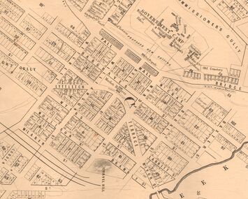
Map - MARKS COLLECTION: MAP SANDHURST 1867
... Inc. History House 11 Mackenzie Street Bendigo goldfields MAP ...Original map: Sandhurst 1867, shows central Bendigo and surrounds, including police camp, stockade, 'old cemetery', reserve for. On bottom of map: 'Lithographed at the Department of Lands and Survey by D. Henderson, 20 February, 1867'. On top RH corner 'Sheet No 1 Sandhurst'.map, bendigo, 1867 sandhurst map -
 Bendigo Historical Society Inc.
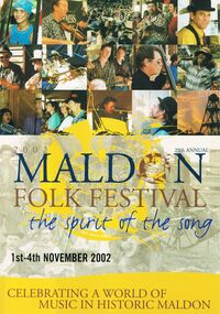
Magazine - PETER ELLIS COLLECTION: MALDON FOLK FESTIVAL
Eight copies of Maldon Folk Festival books for the years 2002, containing a programme alterations loose page; 2003; 2004; 2005; 2006, containing a 2006 Maldon Folk Festival Performers application; 2007; 2008 containing a Maldon Folk Festival Survey form; and 2010, containing a Maldon Folk Festival Survey form. All have colourful front covers with the name and dates printed on them. Also contains features, names of performers, advertisements, programmes and a map of the area. Performers include Emu Creek Bush Band, Wedderburn Old Timers and Peter Ellis.magazine, organization, maldon folk festival, peter ellis collection, emu creek bush band, wedderburn old timers, peter ellis -
 Bendigo Historical Society Inc.
Slide - DIGGERS & MINING. THE GOLD LICENCE, c1854
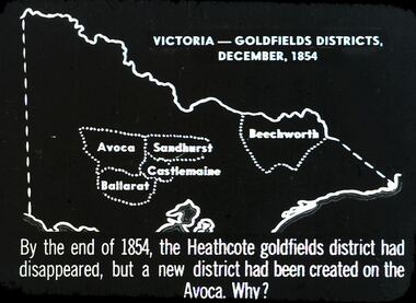
Diggers & Mining. The gold licence. The Government Camp. Slide depicts map of Victoria with the 5 gold rush regions marked on it. Beechworth, Sandhurst Avoca, Castlemaine and Ballarat. By the end of 1854, the Heathcote goldfields district had disappeared, but a district had been created on the Avoca. Why? Markings: 31 994.LIF. 4. Used as a teaching aid.hanimounteducation, tertiary, goldfields -
 Bendigo Historical Society Inc.
Document - PETER ELLIS COLLECTION: NATIONAL FOLK FESTIVAL, 3rd February, 1996
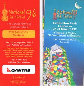
Collection of National Folk Festival programs and literature. Programs from the years 1995, 1996 and 1998. All have colourful covers and contains General Information, information on performers, programs, site maps, some photos of performers and some health information. Some pamphlets include a Ticket Order Form and a larger National Folk Festival 97 where the featured state is Tasmania. Letter to John Williams from Phil Wilson, Director National Folk Festival, dated 3 February 1996 confirming performance and ticket details for Emu Creek Bush Band CD Launch.entertainment, music, national folk festival, peter ellis collection, emu creek bush band, peter ellis -
 Bendigo Historical Society Inc.
Document - PETER ELLIS COLLECTION: NATIONAL FOLK FESTIVAL, 16th - 20th April, 1992
Literature from the 26th National Folk Festival held in Canberra on the 16-20 April 1992. Program containing General Information, the Performers (including the Emu Creek Bush Band), Festival Map, the Programme and Dance Programme Information. Also leaflets: Visitors Guide, Program, Embassies in Canberra, University Halls of Residence Bruce Burton & Garran Halls Information for Visitors, Map of Australian National University, and an article titled 'Real Folk' with information about performers. Pioneer Performers Series Information Sheet April 1992 contains Introduction, Current Available Items, Current Projects, Forthcoming Events and Ramblings of a Modern Day Collector.entertainment, music, national folk festival, peter ellis collection, australian national university, 26th national folk festival canberra 1992, the monaro folk music society, emu creek bush band, wongawilli colonial dance club inc -
 Bendigo Historical Society Inc.
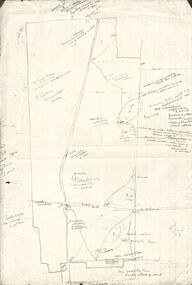
Map - PETER ELLIS COLLECTION: MAP AREA AROUND MITIAMO
... Inc. History House 11 Mackenzie Street Bendigo goldfields MAP ...Copy of a hand drawn map of an area near Mitiamo with various plants/trees, features and Aboriginal Water Holes drawn in. Also a smaller copy of the top part and two smaller copies of the lower half of the map.map, victoria, rushworth/whroo, peter ellis collection, mitiamo area, aborigine water holes -
 Bendigo Historical Society Inc.
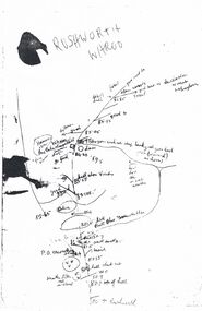
Map - PETER ELLIS COLLECTION: MAP
... Inc. History House 11 Mackenzie Street Bendigo goldfields MAP ...Five photocopies of drawings of the Rushworth area and three copies of Rushworth-Whroo. All maps have various features and some plants noted. Also mentioned is the Balaclava Hill Open Cut Mine.map, victoria, rushworth/whroo, peter ellis collection, rushworth, whroo, aboriginal water holes, balaclava hill open cut mine -
 Bendigo Historical Society Inc.
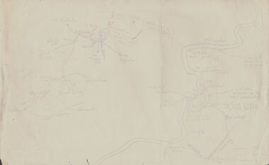
Document - PETER ELLIS COLLECTION: SKETCH OF THE BARFOLD GORGE
Two hand sketched maps on same sheet of paper, one of the location of the Barfold Gorge in relation to surrounding towns, Mt Alexander and Turpin;s Falls. The second map is a part of the Campaspe River location of the Barfold Gorge. Shown is the location of columns, pools, type of rock, Mitchell's Falls, tunnel, cave, Queen's Falls, house, windmill, fences and places where access to the bottom of the gorge is possible. Car track and scale of 1 mile = 6 inches are also shown.place, land, barfold gorge, peter ellis collection, mitchell's falls, queen's falls, turpin's falls -
 Bendigo Historical Society Inc.
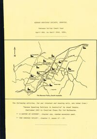
Document - GERMAN HERITAGE SOCIETY COLLECTION: BAROSSA VALLEY COACH TOUR 1994, 8th - 10th April, 1994
Bound collection with a yellow front cover and a buff back cover. Barossa Valley Coach Tour, April 8th to April 10th, 1984. The front has a line map of The Barossa Valley, South Australia. Articles taken from 'German Speaking Settlers in Australia' by Josef Vondra, Published 1981 by Cavalier Press Pty Ltd Melbourne. 'A Matter of History' chapter one, random excerpts used. 'The Barossa Valley', chapter 2, pages 47 - 67. Mentioned in the booklet are the German settlement in the Barossa Valley, the arrival of the Germans in Australia and some of the reasons which led up to why they left their homeland.document, memo, german heritage society, german heritage society collection - barossa valley coach tour 1994, josef vondra, cavalier press pty ltd -
 Bendigo Historical Society Inc.
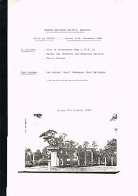
Document - GERMAN HERITAGE SOCIETY COLLECTION: TATURA DISTRICT 1939-1947, Sunday 14th November 1993
Compiled reference articles on the Tatura District, 1939-1947. Information from War Museum Archives, Canberra. File 780/1 (2 pages). Tatura and the Shire of Rodney, by W H Bossence. Walls of Wire, Tatura Rushworth Murchison by Joyce Hammond. The Story of the Beilharz Family by Dr. Paul Sauer. Contains a map, with Internment Camps, of the Shire of Rodney, Prisoners of War in Australia During World War 2, Special Requirements for Internees : Accommodation. Chap. 1, Prisoner of War and Internment Camps at Tatura, Vic., Plan of the Camp. Has a pale yellow front cover and a pale blue back cover.document, memo, german heritage society, german heritage society collection - visit to tatura, german heritage society bendigo, german war cemetry, war museum archives canberra, tatura and the shire of rodney, walls of wire tatura rushworth murchison, the story of the beilharz family, ian walder, geoff pedersen, kurt beilharz -
 Bendigo Historical Society Inc.
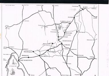
Document - GERMAN HERITAGE SOCIETY COLLECTION: BUILDINGS, MINES & PLACES
Collection of Articles with a map of part of South Australia north of Adelaide. Contains articles and photos about Tailem Bend, Murray Bridge, Kapunda, Burra, Clare, Penwortham, Sevenhill, Eudunda, Mintaro, Watervale, The House of Quelltaler, Leasingham and Auburn. It also contains a story by Gaye Sprenglewski.societies, service clubs, german heritage society, german heritage society collection - colllection of articles about buildings, mines & places, tailem bend, murray bridge, kapunda, burra, clare, penwortham, sevenhill, eudunda, mintaro, watervale, the house of quelltaler, leasingham, auburn, gaye sprenglewski. -
 Bendigo Historical Society Inc.
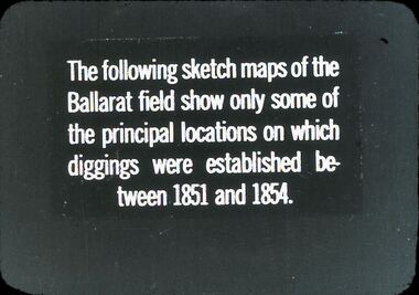
Slide - DIGGERS & MINING: THE DIGGINGS - THE DIGGERS
Diggers & Mining: The Digging - The Diggers. Slide reads: The following sketch maps of the Ballarat field show only some of the principal locations on which diggings were established between 1851 and 1854. Markings: 9 994.LIF:6. Used as a teaching aid.hanimounteducation, tertiary, goldfields -
 Bendigo Historical Society Inc.
Document - GERMAN HERITAGE SOCIETY COLLECTION: MAPS OF GERMANY
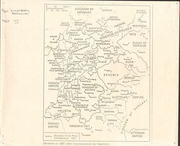
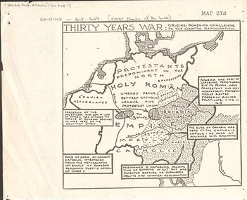
Item 21. Maps of Germany. Germany in 1807 after reconstruction by Napoleon, Germany, Map of Germany States with their Coat of Arms, Thirty Years War Map 21b,Europe in the Time of Henry VIII, Europe in The Time of James I and Charles I, Europe at the End of the 15th Century, Boundaries before 1918 showing Kingdoms, Duchies, provinces, etc., of the Former German Empire (2 copies), Two Grosser Plan Vor Hamburg. Photocopies of Der Rodingsmarkt Hamburg, Kehrwieder Hamburg and Rathhausmarkt und Borse Hamburg. Photocopy of Silesia's Place in History,document, certificate, map of germany, german heritage society collection - maps of germany, theodor w brandt's verlag -
 Bendigo Historical Society Inc.
Document - GERMAN HERITAGE SOCIETY COLLECTION: MAPS OF GERMANY (PERIODS OF CHANGE)
Item 21. Maps of Germany (Periods of Change) held in two buff coloured commerce folders. Name written on the front in purple. Three loose copies of the Thirty Years War Map 21a, 21c and 21d. Maps of the Thirty Years War,Europe at the End of the 15th Century, The Reformation in Europe (16th Century), /Europe in the Time of Charles II & James II, The Domination of France 1660 - 85, Europe in the Time of Henry VIII, Germany in 1807 after reconstruction by Napoleon, German Federation 1815, The German Federation 1815, The German Empire of 1871, The Growth of the German Zollverein, Boundaries Before 1918 showing Kingdoms, Duchies, Provinces, etc., of the Former German Empire, the German Empire (1871 - 1918), and Boundaries before 1918 showing Kingdoms, Duchies, Provinces, etc., of the Former German Empire. The last page has a small map of Europe, a small map showing East and West Berlin, German Coats of Arms, Comparative International Figures of Population and a short article titled 'Do You Know Germany'.document, certificate, maps of germany, german heritage society collection - maps of germany (periods of change) -
 Bendigo Historical Society Inc.
Medal - GOLDEN SQUARE P.S. LAUREL ST. 1189 COLLECTION: CENTENARY OF FEDERATION MEDALLION
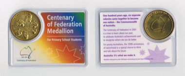
Eleven Centenary of Federation Medallions - For Primary School Students. The medallion is gold coloured with: Australia It's What We Make It and six people moving objects on one side and a rough sketch map of Australia 1901 - 2001 and 'One Hundred Years of Federation' on the other. The end of the line drawing of Australia has a star on it. The back of the card has a brief history and the front has a rainbow colour and the title and dates.Medallion designed by John Skillington and produced buy the Royal Australian Mint.education, primary, golden square laurel st p.s., golden square primary school 1189 collection - centenary of federation medallion - for primary school students, john skillington, royal australian mint -
 Bendigo Historical Society Inc.
Book - THE MONSTER MEETING BOOK
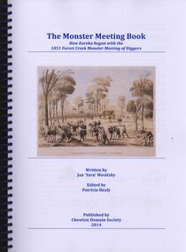
The Monster Meeting Book, how Eureka began with the 1851 Forest Creek monster meeting of diggers, written by Jan'Yarn' Wositzky edited by Patricia Healy published by Chewton Domain Society 2014, in a spring bound binder with 171 pages containing coloured illustrations, photographs and maps.Jan Wositzkyvictoria, history, monster meeting chewton -
 Bendigo Historical Society Inc.
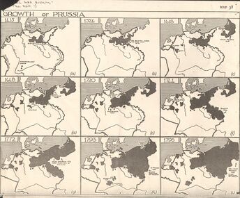
Map - GERMAN HERITAGE SOCIETY COLLECTION: GROWTH OF PRUSSIA
... Inc. History House 11 Mackenzie Street Bendigo goldfields MAP ...Photocopy of a map titled Growth of Prussia. Nine maps with the dates 1415, 1524, 1618, 1648, 1720, 1744, 1772, 1793 and 1795. Maps have letters (a) to (i) as well.map, german heritage society collection - growth of prussia-map 38 -
 Bendigo Historical Society Inc.
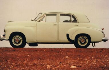
Photograph - PETER ELLIS COLLECTION: HOLDEN CAR
Coloured photograph. Old Holden car. Rocky hill. Back of photo reads: Between Coober Pedy and Marla on route to Alice Springs National Folk Festival Easter 1987. (then in different writing) This car, FJ Holden (1954-1956) was Peter Ellis's, previously used by Doc Robbins to map the Whipstick before Peter bought it.photo, individual, peter ellis car -
 Bendigo Historical Society Inc.
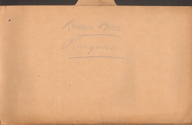
Document - MCCOLL, RANKIN AND STANISTREET COLLECTION: REIMER BROS. KINGOWER
Manilla folder containing correspondence relating to Reimer Brothers claim at Kingower, also contains a large scale parish map of Kingower showing the position of the claim and leases 6278 held by Andrew Thomas Berriman and 6279 held by Florence Adelaide BerrimanMcColl Rankin & Stanistreetgold mining, miners' safety cage, kingower/union reef mines, gold mining, kingower, reimer brothers berriman -
 Bendigo Historical Society Inc.
Document - MCCOLL, RANKIN AND STANISTREET COLLECTION: SUNDRY REPORTS, 1930's
... . Map with lines of reef showing the position of the New Moon.... Map with lines of reef showing the position of the New Moon ...Manilla Folder containing reports from various mines in Bendigo and surrounding areas. 1. 4 page typewritten report on the Balaclava Hill Mine at Rushworth and some newspaper clippings about the mine with a plan of the underground workings; 2. Page from the Árgus' dated 2nd August 1900 featuring an article on the survey of the Garden line of Reefs; 3. 5 page report with maps on the Tooleen Gold Field; 4. Single page report about an unnamed mining area claimed to be on the southern end of the Deborah line of reef. (this could be the 'Three Jays' mine in Sedgwick. P. Wilkin); 5. Hand written report on the Coronation Mine, 2 miles east of Walhalla.; 6. Hand written report dated 1935, of the Queen Mary mine, St. Arnaud.; 7. 1932 report on the North Neangar lease.; 8 4 page report on the Kings Prize Gold Mining Syndicate.; 9. Description of the plant of the Marong Alluvial Company? Also a guide for marking out leases.; 10. Crushing details (1 page) from the 'Enterprise' Mine South of and adjacent to Perseverence.; 11. 1 page crushing details from Rowe Brothers, Mosquito Mine, Fryerstown.; 12 hand written report mentions Arthur Hatfield, Scarsdale.; 13. Map with lines of reef showing the position of the New Moon Consolidated and the New Moon United shafts.; 14, Large scale map from Harrison/Victoria street to Havilah Road showing the positions of the Carlisle, North Garden and Unity Shafts.gold mining, miners' safety cage, sundry reports, mining. bendigo, rushworth, balaclava hill, garden line of reef, toolleen, coronation mine, walhalla, queen mary mine, st. arnaud. north neangar, kings prize gold mining syndicate, marong, enterprise mine, perseverence, rowe brothers, mosquito mine, fryerstown, arthur hatfield, scarsdale, new moon consolidate, new moon united, carlisle, north garden, unity. -
 Bendigo Historical Society Inc.
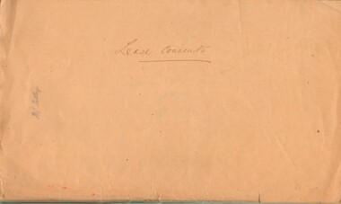
Document - MCCOLL, RANKIN AND STANISTREET COLLECTION: LEASE CONSENTS
Manilla Folder containing correspondence and consents relating to the following Gold Mining Leases; 10819, 10027 (North Virginia Gold Mining Co.);, 10370 Great Eastern (Bendigo), includes map; 10014, South monument; 10059 North Neanger, with map; 10072 ; 10104; North Virginia; 10068 New Don Company with Map; 10032 New Balaclava, Whroo; 10026 East Clarence Gold M/C. Dated 1933 - 34gold mines, bendigo, gold mines, north virginia, great eastern, south monument, north neanger, new don, east clarence, new balaclava -
 Bendigo Historical Society Inc.
Document - MCCOLL, RANKIN AND STANISTREET COLLECTION: TAMBOUR MAJOR LEASE, 1939/1940
Manilla Folder containing Lease application and correspondence for lease No. 11007 (Tambour Major). Includes Map of lease. Also references to lease Numbers 10168 and 10899. Dated September 1939McColl Rankin & Stanistreet, Charing Cross Bendigo.gold mining, miners' safety cage, tambour major lease, gold mines, bendigo tambour major -
 Bayside Gallery - Bayside City Council Art & Heritage Collection
Map, H.B. Foot, Plan of the Brighton Estate containing 5120 acres, first special survey at Port Phillip, c. 1842
This plan records the Brighton Estate, also known as Dendy's Special Survey. In 1840 Henry Dendy, a farmer in Surrey, England acquired a "Special Survey" from the Commissioners for Land and Emigration which gave him the right to choose land in Port Phillip for the low price of £1 per acre for 5120 acres. Dendy appointed Jonathan Binns Were, as his agent, who later became a partner. Together, Dendy and Were decided on an area 5 miles south from Melbourne, bounded by North Road, East Boundary Road, South Road and to the west by Port Phillip Bay. Their Brighton Estate was first surveyed by T. S. Townsend in May 1841 and was re-surveyed by Robert Hoddle. Dendy and Were were making plans to sell the land and advertised a 30-guinea prize for the best subdivision which was to be divided into a village, marine residences, suburban and cultivation allotments, with the remainder being divided into country sections. The competition was won by H.B. Foot, who planned the village around a reserve and crescents and a 'green belt' forming the town boundary. brighton estate, dendy's special survey, special survey, henry dendy, jonathan binns were, w.b. were, survey, plan, map, brighton, george ward cole, baker's lithographer, hibernian, subdivision, town planning, cartographic material, h.b. foot -
 Bayside Gallery - Bayside City Council Art & Heritage Collection
Map, Department of Crown Lands and Survey et al, Moorabbin, County of Bourke, Government Roads, 1920
The cadastral map of the Parish of Moorabbin in Victoria (L.6104) shows parish boundaries and land ownership 1920 when Sandringham was a Town. The government roads have been coloured in red pencil.moorabbin, county of bourke, map, plan, land subdivision, land titles, foreshores, hampton, beaumaris, highett, cheltenham, department of lands and survey, land owners, cartographic material, brighton, sandringham, town of sandringham, government roads -
 Bayside Gallery - Bayside City Council Art & Heritage Collection
Photograph, Department of Crown Lands and Survey, Victoria, Melbourne Project: Brighton and Elwood, 1976
The Department of Crown Lands and Survey (1857-1983) was responsible for the administration of survey and mapping and the sale, occupation and management of crown land throughout its existence. This aerial photograph shows parts of Brighton and Elwood and was taken on 1 December 1976brighton, elwood, department of crown lands and survey, aerial photograph, elsternwick park, point ormond, north road, ormond esplanade, st kilda street, glen huntly road, bayside, port phillip bay, map, cartographic material, melbourne project 1976 -
 Bayside Gallery - Bayside City Council Art & Heritage Collection
Photograph, Department of Crown Lands and Survey, Victoria, Melbourne Project: Brighton, Hampton, Sandringham, 1976
The Department of Crown Lands and Survey (1857-1983) was responsible for the administration of survey and mapping and the sale, occupation and management of crown land throughout its existence. This aerial photograph shows parts of Brighton, Hampton and Sandringham and was taken on 1 December 1976brighton, department of crown lands and survey, aerial photograph, bayside, port phillip bay, map, cartographic material, hampton, sandringham, green point, sandringham yacht club, south road, beach road, hampton street, melbourne project 1976 -
 Bayside Gallery - Bayside City Council Art & Heritage Collection
Photograph, Department of Crown Lands and Survey, Victoria, Melbourne Project: Brighton, 1976
The Department of Crown Lands and Survey (1857-1983) was responsible for the administration of survey and mapping and the sale, occupation and management of crown land throughout its existence. This aerial photograph shows parts of Brighton and was taken on 1 December 1976brighton, department of crown lands and survey, aerial photograph, bayside, port phillip bay, map, cartographic material, melbourne project 1976, brighton yacht club, middle brighton baths, north road, st kilda street, new street -
 Bayside Gallery - Bayside City Council Art & Heritage Collection
Photograph, Department of Crown Lands and Survey, Victoria, Melbourne Project: Brighton and Hampton, 1976
The Department of Crown Lands and Survey (1857-1983) was responsible for the administration of survey and mapping and the sale, occupation and management of crown land throughout its existence. This aerial photograph shows parts of Brighton and Hampton and was taken on 1 December 1976. brighton, department of crown lands and survey, aerial photograph, bayside, port phillip bay, map, cartographic material, melbourne project 1976, brighton yacht club, middle brighton baths, hampton, green point, brighton beach, south road, the esplanade, hampton street -
 Bayside Gallery - Bayside City Council Art & Heritage Collection
Photograph, Department of Crown Lands and Survey, Victoria, Brighton, Elwood and Elsternwick, c. 1965-71
The Department of Crown Lands and Survey (1857-1983) was responsible for the administration of survey and mapping and the sale, occupation and management of crown land throughout its existence. This aerial photograph shows parts of Brighton, Elwood and Elsternwick and was taken circa 1965-71.brighton, department of crown lands and survey, aerial photograph, bayside, port phillip bay, map, cartographic material, elwood, elsternwick, elsternwick park, elwood tram depot, elwood pier, new street, glen huntly road, st kilda street, nepean highway -
 Bayside Gallery - Bayside City Council Art & Heritage Collection
Photograph, Department of Crown Lands and Survey, Victoria, Brighton, Brighton East and Bentleigh, c. 1965-71
The Department of Crown Lands and Survey (1857-1983) was responsible for the administration of survey and mapping and the sale, occupation and management of crown land throughout its existence. This aerial photograph shows parts of Brighton, Brighton East and Bentleigh and was taken circa 1965-71.brighton, department of crown lands and survey, aerial photograph, bayside, port phillip bay, map, cartographic material, bentleigh, brighton east, dendy park, dendy street, centre road, nepean highway, south road, football