Showing 41 items matching " canterbury railway line"
-
 Canterbury History Group
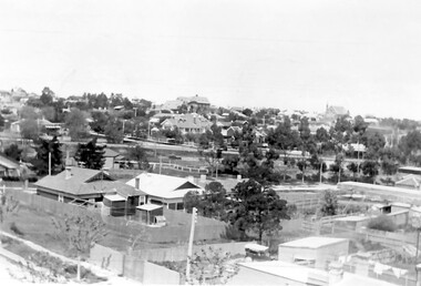
Photograph - Canterbury 1932, 1932
... ... Canterbury Railway Line...Canterbury History Group 190A Canterbury Road Canterbury melbourne Newspaper photograph of Canterbury from "the Argus" Camera Supplement, 6 August 1932 Canterbury Canterbury Railway Line Canterbury Road Rochester Road Emulation Hall Shops Gardens Shrublands Black and white photo Photograph Canterbury 1932 ...Newspaper photograph of Canterbury from "the Argus" Camera Supplement, 6 August 1932Black and white photocanterbury, canterbury railway line, canterbury road, rochester road, emulation hall, shops, gardens, shrublands -
Canterbury History Group
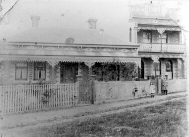
Photograph - Canterbury, C1900
... ...Canterbury Railway Line...Canterbury History Group 190A Canterbury Road Canterbury melbourne Photograph of Canterbury taken from Canterbury Road, looking towards the south and Maling Road Canterbury Canterbury Road Maling Road Canterbury Station Canterbury Railway Line Black & white photograph Photograph Canterbury ...Photograph of Canterbury taken from Canterbury Road, looking towards the south and Maling RoadBlack & white photographcanterbury, canterbury road, maling road, canterbury station, canterbury railway line -
Canterbury History Group
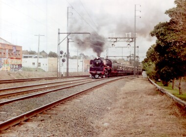
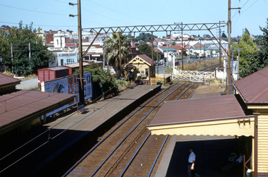
Article, Victorian Railways, Big Grade Separation Job At Canterbury, May 1966
... Canterbury Railway Station...Canterbury Railway Line...Canterbury History Group 190A Canterbury Road Canterbury melbourne Railways Canterbury Railway Station Canterbury Railway Line Article on the plans to duplicate the railway lines and raise the track at Canterbury 2 pages includes black and white photos Big Grade Separation Job At Canterbury Article Victorian Railways ...Article on the plans to duplicate the railway lines and raise the track at Canterbury2 pages includes black and white photosArticle on the plans to duplicate the railway lines and raise the track at Canterburyrailways, canterbury railway station, canterbury railway line -
 Bendigo Historical Society Inc.
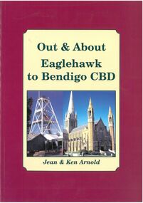
Book - Out & About Eaglehawk to Bendigo CBD
... railway line before turning west roughly following Violet Street. Plaques Monuments Burgundy Outline with Cream Insert with photos of Cathedral and Central Deborah Mine. Rear Cover Canterbury ...This book covers the Bendigo CBD area from Valentine street north east to Nolan Street past Lake Weroona then along the railway line before turning west roughly following Violet Street. Burgundy Outline with Cream Insert with photos of Cathedral and Central Deborah Mine. Rear Cover Canterbury Park Eaglehawk and photos of Rosalind Park - Authors Jean and Ken Arnold - 88 Pagesplaques, monuments -
 Ringwood and District Historical Society
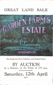
Pamphlet, G.A. Green, Auction Sale Brochure - Garden Farms Estate, Ringwood, Victoria - 1919, 1919
... Railway Station site of Canterbury Road; therefore, the whole Estate is easy of access and there should be a large demand for land so favourably placed. (Image) Cultivation Field - Potatoes on Lot 28 (Image) Picture of Bayswater Creek Flats. (Image) View from "Korumbeen" where Mr. Armstrong lived on Garden Farms Estate. Estate outlined in white ring. (Image) Site of New Bridge over Dandenong Creek. (Image) On one of the timbered lots adjoining railway. (Image) This Dandenong Creek traveres the Estate. (Image) Main Fern Tree Gully Line...Railway Station site of Canterbury Road; therefore, the whole Estate is easy of access and there should be a large demand for land so favourably placed. (Image) Cultivation Field - Potatoes on Lot 28 (Image) Picture of Bayswater Creek Flats. (Image) View from "Korumbeen" where Mr. Armstrong lived on Garden Farms Estate. Estate outlined in white ring. (Image) Site of New Bridge over Dandenong Creek. (Image) On one of the timbered lots adjoining railway. (Image) This Dandenong Creek traveres the Estate. (Image) Main Fern Tree Gully Line ...Multi-fold brochure advertising public auction of one-acre, 2-acre, 5-acre and 8-acre allotments in Ringwood and Bayswater on Saturday 12th April, 1919. Brochure includes terms of sale, description of subdivision features and local facilities, and photographic images of the area.Subdivison includes Canterbury Road Heathmont, Armstrong Road Heathmont, Armstrong Road Bayswater, Bungalook Road Heathmont, Bungalook Road Bayswater, and Orchard Road Bayswater. Road shown as Bayswater Road to Bayswater became Mountain Highway Bayswater. Vendor: H.E.B.Armstrong, Auctioneers: Coghill & Haughton, 79 Swanston Street Melbourne, Telephone Central 2793, in conjunction with J.B. McAlpin, Ringwood, Opposite Station, Telephone Ringwood 7. (Map) Woodcock & McCormack, Civil Engineers Architects & Surveyors, 430 Little Collins Street, Melbourne, Phone 3241 Central. MOST OF THE MONEY COMES OUT OF THE LAND. And more money can be obtained from anb acre of fruit than from an acre of any other produce. But you do not have to grow fruit on Garden Farms Estate. You can go in for - Outer Suburban Home - Market Garden - Orchard - Pig Raising - Poultry Farm - Small Dairy Farm - Small Fruits - Floral Culture - Scent and Bee Farm - Or just for a Week-end Home. RINGWOOD - THE PLACE TO LIVE. The Beautiful Ringwood District has so many natural attractions, that half a Land Agent's work is done in just showing a prospective buyer round and about. Ringwood has a pull of its own that attracts folk, proved beyond doubt by its rapid development within the last decade (spite the war). First, it is high and healthy, picturesque and undulating, convenient of access, sufficiently close to the Metropolis for City and Business folk to live at Ringwood. Its development is solid, because most of its people are industrious husbandmen, real producers, who have turned idle hills into smiling gardens. These are the kind of real people to live amongst; ones who wear out their spades. The rapidly-developing town has excellent Stores, Trade and Repair Shops Churches, Banks, Telephone Exchange, Weekly General Market, Cool Stores, and good Private and State Schools, etc.; is Electrically lit, has Metropolitan Water Supply, and generally provides so that practically all shopping can be done locally. WHY RINGWOOD MUST GROW. Ringwood is a great centre and must be a greater. Two rapidly-developing railways junction here. The passengers from Ringwood Station cityward, in one year, number 250,000. Ringwood will be the terminus of the Outer Suburban Electric Eastern Railway. Its natural boundaries are the River Yarra on the North, Dandenong Creek on the South, the popular town of Croydon on the East, and the suburb of Mitcham on the West. This is a large territory that is steadily being converted from intense culture, and then it might be called (as regards its gardens) "The Devon Territory of Victoria." ARMSTRONG ROAD. This new road traverses Garden Farms Estate from its northern boundary on the main Canterbury Road, across Dandenong Creek, to its southern boundary on the main Bayswater Road, and will provide a long-desired additional link of communication between Bayswater and Ringwood. The 1-acre building sites on Bayswater Road are within 8 minutes' walk of the Bayswater Railway Station, and the Canterbury Road frontages are only 1-1/2 miles from Ringwood Station, and 1/2 mile from the Railway Station site of Canterbury Road; therefore, the whole Estate is easy of access and there should be a large demand for land so favourably placed. (Image) Cultivation Field - Potatoes on Lot 28 (Image) Picture of Bayswater Creek Flats. (Image) View from "Korumbeen" where Mr. Armstrong lived on Garden Farms Estate. Estate outlined in white ring. (Image) Site of New Bridge over Dandenong Creek. (Image) On one of the timbered lots adjoining railway. (Image) This Dandenong Creek traveres the Estate. (Image) Main Fern Tree Gully Line bisects the Estate. -
 Ringwood and District Historical Society
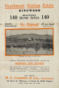
Flyer, Land Sale Brochure, Heathmont Station Estate, Ringwood, Vic. - circa 1925
... Railway Commissioners is to electrify the line to the Gully as soon as convenient, and with greater frequency of service many persons settled, and settling, in the district will be benefited. There is a scheme which may be launched that will allow for an express service of fast trains to the Gully. The commissioners are alive to the necessity for assisting to settle the picturesque districts between Box Hill and Gembrook. Subdivision includes Canterbury ...Extract of "Herald" 2/2/22: The intention of the Railway Commissioners is to electrify the line to the Gully as soon as convenient, and with greater frequency of service many persons settled, and settling, in the district will be benefited. There is a scheme which may be launched that will allow for an express service of fast trains to the Gully. The commissioners are alive to the necessity for assisting to settle the picturesque districts between Box Hill and Gembrook.Bi-fold advertisement for sale of retail and residential sites, including panoramic and other photographs, map, and summary of subdivision features and local facilities. Subdivision includes Canterbury Road, Station Street (later Wainui Avenue), Lisgoold Street, Viviani Crescent, and Balfour Avenue. Agent - H.C. Costello & Co., Auctioneer, 128 Queen Street, Melbourne, or Church Street, Middle Brighton. Phones: Central 10517 and X1205. -
Box Hill Historical Society
Photograph - Aerial Photographs
... Railway line visible through the trees. The water tower in Elgar Road and the communications tower in Canterbury Road is visible....Railway line visible through the trees. The water tower in Elgar Road and the communications tower in Canterbury Road is visible. ...Aerial photograph of Bank street, Box Hill - looking west - showing the ANZ Bank on the corner of Station Street and Main Street, and Whitehorse Plaza in the background. C.1970's. Railway line visible through the trees. The water tower in Elgar Road and the communications tower in Canterbury Road is visible.whitehorse plaza, anz bank, bank street, station street, main street, shopping centres, banks, transport, water towers, telecommunications equipment, aerial photographs -
Box Hill Historical Society
Book, City of Box Hill, Albion Road. Local Area Traffic Management Scheme, c.1986
... Canterbury Road...Middleborough Road...Railway line...It covers the area bounded by Station Street, Canterbury Road, Middleborough Road and the railway line at Box Hill....Box Hill Historical Society Box Hill Heritage Centre Suite 7 Town Hall Hub Box Hill melbourne Traffic Management Station Street Canterbury Road Middleborough Road Railway line Box Hill Land use Car Parks Ellingworth Parade John Street Albion Road Rutland Road Sweetland Road Barkly Street William Street Traffic accidents Bus Services Town planning A traffic management study and scheme that was implemented during the 1980's as a result of concerns by local residents. ...A traffic management study and scheme that was implemented during the 1980's as a result of concerns by local residents. It includes land use, traffic accidents, bus routes, trip tables and maps. It covers the area bounded by Station Street, Canterbury Road, Middleborough Road and the railway line at Box Hill.traffic management, station street, canterbury road, middleborough road, railway line, box hill, land use, car parks, ellingworth parade, john street, albion road, rutland road, sweetland road, barkly street, william street, traffic accidents, bus services, town planning -
 Surrey Hills Historical Society Collection
Photograph, D716 steam train at Mont Albert Station, 1919, 1919
... Canterbury melbourne The photo was taken at 8.15am on Friday 12 September 1919. The D class was a passenger and mixed traffic steam locomotive which operated on the Victorian Railways from 1902 to 1974. Originally it was introduced on mainline express passenger services, but they were quickly superseded by the much larger A2 class and were relegated to secondary and branch line passenger and goods service, where they continued in service for the next fifty years. ...The photo was taken at 8.15am on Friday 12 September 1919. The D class was a passenger and mixed traffic steam locomotive which operated on the Victorian Railways from 1902 to 1974. Originally it was introduced on mainline express passenger services, but they were quickly superseded by the much larger A2 class and were relegated to secondary and branch line passenger and goods service, where they continued in service for the next fifty years. The D716 was probably built at the Newport Workshops, post 1910 and before 1914. The expansion of Melbourne's population into new suburbs early in the 20th century, and the delay of the suburban electrification project, meant there was the need for faster and more powerful steam locomotives for the suburban rail network. In 1908, the basic design was adapted to create a more powerful locomotive. They were put to work on longer and hillier suburban routes including the Lilydale line. A total of 58 were built between 1908 and 1913. See wikipedia for a more detailed history of the D class locomotives. Electric trains replaced steam in 1922. Mr William Holmes of 'Lugano', Mont Albert Road was in charge of the design and introduction of the electrification of the Melbourne rail system.Black and white photo of a steam train approaching the platform at Mont Albert station. Rear in blue biro in Jocelyn Hall's handwriting: "Hamilton St Mont Albert / probably 1919".mont albert station, railways, trains, d class locomotives, norman carter, steam trains -
 Surrey Hills Historical Society Collection
Photograph, A Yarra Glen Special approaching Surrey Hills, 1986
... Surrey Hills Historical Society Collection 190A Canterbury Road Canterbury melbourne A Yarra Glen Special in 1986 at Surrey Hills graffiti surrey hills steam train trains 1986 Harris carriages On rear of photo : "A Yarra Glen Special / 1986/ at Surrey Hills" A coloured photograph of a steam train bellowing lots of smoke approaching Surrey Hills station. On the LHS is Stirling Crescent; on the RHS is Sunbury Crescent. There is graffiti on the buildings adjacent to the railway line ...A Yarra Glen Special in 1986 at Surrey HillsA coloured photograph of a steam train bellowing lots of smoke approaching Surrey Hills station. On the LHS is Stirling Crescent; on the RHS is Sunbury Crescent. There is graffiti on the buildings adjacent to the railway line on the LHS.On rear of photo : "A Yarra Glen Special / 1986/ at Surrey Hills"graffiti, surrey hills, steam train, trains, 1986, harris carriages -
 Surrey Hills Historical Society Collection
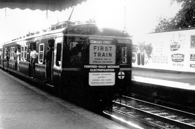
Photograph, Leaving Surrey Hills - the rear of first electric surburban train to Belgrave, 1962, 18/02/1962
... Surrey Hills Historical Society Collection 190A Canterbury Road Canterbury melbourne This was a special run for rail enthusiasts and marked the official opening of the first train from Ferntree Gully to Belgrave after the line from Upper Ferntree Gully was converted to broad gauge and electrified. surrey hills transport trains railways rail electrification special rail excursions official opening A sign at the rear of the train states: "First train / Sunday February 18 / Special Excursion / Ferntree Gully Belgrave / Electrification" A black and white photograph of the rear of a train with passengers alighting at Surrey Hills station. ...This was a special run for rail enthusiasts and marked the official opening of the first train from Ferntree Gully to Belgrave after the line from Upper Ferntree Gully was converted to broad gauge and electrified.A black and white photograph of the rear of a train with passengers alighting at Surrey Hills station. Signage on the rear indicates that the train was a special excursion marking the electrification of the rail from Ferntree Gully to Belgrave.A sign at the rear of the train states: "First train / Sunday February 18 / Special Excursion / Ferntree Gully Belgrave / Electrification"surrey hills, transport, trains, railways, rail electrification, special rail excursions, official opening -
 Surrey Hills Historical Society Collection
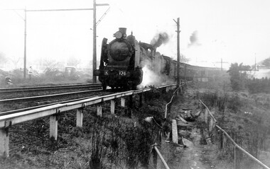
Photograph, Loco K176 at Surrey Hills on a vintage tour train to Healesville, 1 October 1966, 1 October 1966
... Canterbury melbourne We have an original B&W copy donated by Ian Barkla and a larger one copied by Ken Hall. The Barkla original has a sticker with his reference details on the back. The photo records a Vintage Train tour to Healesville on 1 October 1966. The Lilydale to Healesville line opened on 1 March 1889. The last steam train on the line ran in 1957 and the last passenger service was in 1980. The line reopened as a tourist railway ...We have an original B&W copy donated by Ian Barkla and a larger one copied by Ken Hall. The Barkla original has a sticker with his reference details on the back. The photo records a Vintage Train tour to Healesville on 1 October 1966. The Lilydale to Healesville line opened on 1 March 1889. The last steam train on the line ran in 1957 and the last passenger service was in 1980. The line reopened as a tourist railway in 2010. Although the photo was taken on a misty day, houses in Windsor Crescent can just be seen in the background. It is possibly Lorne Parade in the background with preparatory works for the 3rd rail line underway.A black and white photocopy of a steam train. One person is looking on from the left hand side of the photo. It's a misty day but houses in Windsor Crescent and the pedestrian overpass at Surrey Hills railway station can be seen.surrey hills railway station, windsor cresent, 1966, railfan tour, steam trains, vintage tour train -
 Surrey Hills Historical Society Collection
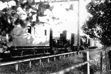
Photograph, Narrow Gauge Garratt Loco G 42 being transferred through Surrey Hills to Belgrave
... Surrey Hills Historical Society Collection 190A Canterbury Road Canterbury melbourne The G42 Garratt Steam Locomotive was one of two heavier more powerful locomotives that operated on Victoria's narrow gauge railways. These Beyer Garratt locomotives were built in Manchester, England and delivered in 1926. They were numbered G41 and G42. They operated on the Colac–Beech Forest–Crowes line ...The G42 Garratt Steam Locomotive was one of two heavier more powerful locomotives that operated on Victoria's narrow gauge railways. These Beyer Garratt locomotives were built in Manchester, England and delivered in 1926. They were numbered G41 and G42. They operated on the Colac–Beech Forest–Crowes line and the Moe–Walhalla line respectively. After the line from Moe closed in 1954, G42 was sent to Colac, where it worked until closure of that line in mid-1962. At that time the G41 was in poor condition and was scrapped. G42 was offered to the Puffing Billy Preservation Society.A black and white photocopy of a goods train and carriages.surrey hills, trains, goods carriages, g42 garratt steam locomotive, puffing billy preservation society, victorian railways -
 Surrey Hills Historical Society Collection
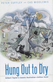
Book, Hung out to dry: Gilbert Toyne's classic Australian clothes hoist, 2009
... Surrey Hills Historical Society Collection 190A Canterbury Road Canterbury melbourne Archibald McKirdy purchased the Toyne's hoist business in 1925 and moved its production from Carnegie to Mont Albert where the family had lived since the 1880s. The factory was in Mont Albert Road near the railway line ...Archibald McKirdy purchased the Toyne's hoist business in 1925 and moved its production from Carnegie to Mont Albert where the family had lived since the 1880s. The factory was in Mont Albert Road near the railway line and the family lived at 2 Stanhope Street. 'Hung Out to Dry' is based on detailed and innovative research and analysis; part family history, part social history, part industrial history, part garden history. It is the story of the rotary clothes hoist.'Hung Out to Dry' is based on detailed and innovative research research and analysis; part family history, part social history, part industrial history, part garden history. It is the story of the rotary clothes hoist.(mr) gilbert toyne, inventors, (mr) archibald mckirdy, clothes lines, (mr) peter cuffley, cas middlemis -
Surrey Hills Historical Society Collection
Work on paper - Vertical file, Anne's Pantry
... Surrey Hills Historical Society Collection 190A Canterbury Road Canterbury melbourne Anne's pantry was one of the early shops in the 1920s-1930s shops to be built to the north of the railway line. ...Anne's pantry was one of the early shops in the 1920s-1930s shops to be built to the north of the railway line. It was started by Miss Cook and Miss Porteous and has had a continuous history since, although it has changed location within the strip several times. No-one seems to know the origin of the name 'Anne'. Nick and Judy Hilverda took over in 1971. Vertical file of information related to the Union Road business known as Anne's Pantry: 1. Anne’s pantry cake shop notes written by Miss Porteous Nov. 1979 (2 handwritten pages). 2. Typed copy of No. 1 (2 pages). 3. ‘Twenty years over a hot stove!’ SHNN, Oct.-Nov. 1991 (1 page). 4. ‘Anne’s pantry – it’s history’, E. Porteous, Nov. 1979 (1 page).anne's pantry, nick hilverda, judy hilverda, miss cook, miss e porteous -
 Surrey Hills Historical Society Collection
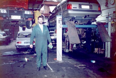
Photograph, Philip Warren-Smith at J&V Warren-Smith Auto Service, 1991
... Surrey Hills Historical Society Collection 190A Canterbury Road Canterbury melbourne The land along the eastern side of the Union Road shops between Montrose Street and the railway line was originally owned by the Zeplin family. ...The land along the eastern side of the Union Road shops between Montrose Street and the railway line was originally owned by the Zeplin family. It was subdivided in 1914 and offered for sale as individual sites. Building did not occur until after WW1 and after the creek across Union Road had been barrelled. The garage was built at 145 Union Road in 1925. It has had continuous use as a garage since then. Originally there were petrol bowsers on the footpath. The façade of the building is remarkably the same as it was in 1925 when David Denholm was the first proprietor. He remained until c1950 and was followed by Benchley Motors P/L, then Spenden Motors P/L. John and Val Warren-Smith purchased it in c1980. In 2019 their family, including Philip and Glenn Warren-Smith and 2 of Philip's sons, still operate it as J&V Warren-Smith Auto Service.The Union Road shopping strip was assessed for heritage protection by Lovell Chen in June 2011 (Surrey Hills and Canterbury Hill Estate Heritage Study: Union Road Commercial Precinct Citation). Within this report two buildings were mentioned as, unusually, still performing their original role. These were Dartnell’s Pharmacy at 376-378 Canterbury Road (contributory) and the motor garage at 145 Union Road (contributory). This is one of a number of 3 images taken in 1991 which document the interior and function of the building.A colour photo of a man in green overalls inside the workshop of a garage. There are two cars up on hoists and three towards the back of the workshop.philip warren-smith, val warren-smith, john warren-smith, j&v warren-smith auto service, benchley motors p/l, spenden motors p/l, garages, union road, businesses, glenn warren-smith, cars -
 Surrey Hills Historical Society Collection
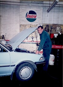
Photograph - Black and White Photograph, J & V Warren-Smith Auto Service, 1991
... Surrey Hills Historical Society Collection 190A Canterbury Road Canterbury melbourne The land along the eastern side of the Union Road shops between Montrose Street and the railway line was originally owned by the Zeplin family. ...The land along the eastern side of the Union Road shops between Montrose Street and the railway line was originally owned by the Zeplin family. It was subdivided in 1914 and offered for sale as individual sites. Building did not occur until after WW1 and after the creek across Union Road had been barrelled. The garage was built at 145 Union Road in 1925. It has had continuous use as a garage since then. Originally there were petrol bowsers on the footpath. The façade of the building is remarkably the same as it was in 1925 when David Denholm was the first proprietor. He remained until c1950 and was followed by Benchley Motors P/L, then Spenden Motors P/L. John and Val Warren-Smith purchased it in c1980. In 2019 their family, including Philip and Glenn Warren-Smith and 2 of Philip's sons, still operate it as J&V Warren-Smith Auto Service.The Union Road shopping strip was assessed for heritage protection by Lovell Chen in June 2011 (Surrey Hills and Canterbury Hill Estate Heritage Study: Union Road Commercial Precinct Citation). Within this report two buildings were mentioned as, unusually, still performing their original role. These were Dartnell’s Pharmacy at 376-378 Canterbury Road (contributory) and the motor garage at 145 Union Road (contributory). This is one of a number of 3 images taken in 1991 which document the interior and function of the building.A colour photo of a man in green overalls working on a car with its bonnet up.john warren-smith, val warren-smith, philip warren-smith, glenn warren-smith, j&v warren-smith auto, union road, businesses, garages, cars, mechanics -
 Surrey Hills Historical Society Collection
Photograph, Wally Hoersch of J&V Warren-Smith Auto, 1991
... Surrey Hills Historical Society Collection 190A Canterbury Road Canterbury melbourne The land along the eastern side of the Union Road shops between Montrose Street and the railway line was originally owned by the Zeplin family. ...The land along the eastern side of the Union Road shops between Montrose Street and the railway line was originally owned by the Zeplin family. It was subdivided in 1914 and offered for sale as individual sites. Building did not occur until after WW1 and after the creek across Union Road had been barrelled. The photo was taken in the office of the garage which was built at 145 Union Road in 1925. It has had continuous use as a garage since then. Originally there were petrol bowsers on the footpath. The façade of the building is remarkably the same as it was in 1925 when David Denholm was the first proprietor. He remained until c1950 and was followed by Benchley Motors P/L, then Spenden Motors P/L. John and Val Warren-Smith purchased it in c1980. In 2019 their family, including Philip and Glenn Warren-Smith and 2 of Philip's sons, still operate it as J&V Warren-Smith Auto Service. The man on the phone is Walter Kurt (Wally) Hoersch. Warmly regarded and often mistakenly thought to be Philip's father, he was not a member of the family. Wally had an interesting background, not known to many. He was born in the German Templer colony of Sarona in Palestine. It had been established in Ottoman Palestine in 1871 and is now a suburb of Tel Aviv. In July 1941, 188 people from Sarona were deported to Australia on the Queen Elizabeth. Wally's family were amongst them. They were interned in Tatura in Central Victoria until 1947. Wally lived in Mont Albert North and later Templestowe; he died on 21/7/2002.The Union Road shopping strip was assessed for heritage protection by Lovell Chen in June 2011 (Surrey Hills and Canterbury Hill Estate Heritage Study: Union Road Commercial Precinct Citation). Within this report two buildings were mentioned as, unusually, still performing their original role. These were Dartnell’s Pharmacy at 376-378 Canterbury Road (contributory) and the motor garage at 145 Union Road (contributory). This is one of a number of 3 images taken in 1991 which document the interior and function of the building.A colour photo of a man sitting behind a desk in an office on the phone. There is another man standing behind him to his right.john warren-smith, val warren-smith, philip warren-smith, glenn warren-smith, walter hoersch, wally hoersch, j&v warren-smith auto, union road, businesses, garages, benchley motors p/l, spenden motors p/l, -
 Surrey Hills Historical Society Collection
Photograph, Surrey Hills looking south-east from the steeple of Holy Trinity Church, 1921, 1921
... Black and white photo taken from the steeple of Holy Trinity Church looking across housing towards the railway line and Albany / Windsor Crescents and on towards Canterbury Road. ...The photographer Norman Carter took many photos of Surrey Hills and Mont Albert from the 1920s, in particular of events and activities associated with the Church of England. albany crescent windsor crescent st stephens presbyterian church surrey hills primary school railways stationmasters' houses bedford avenue norman carter edgeware dr percy liddle dr james blakie On back of original: "6-11-21" and in a different hand in biro: "from tower of Holy Trinity Church" Black and white photo taken from the steeple of Holy Trinity Church looking across housing towards the railway line and Albany / Windsor Crescents and on towards Canterbury Road. ...The property in the foreground is 'Edgeware' at 171 Union Road, a house built by the Zeplin family. It became the home / residence of Dr Percy Liddle and later Dr James Landells Blakie. By the time this photo was taken Dr Blakie had moved across the road to 174 Union Road. In the background behind the 2 houses in the foreground is the Surrey Hills Stationmaster's house, sitting behind a picket fence. The Alan Holt register gives a build date of c1915 for this house, which fits stylistically. The first stationmaster was probably Michael Ginnane, who stayed in the area after he retired, moving to 1 Russell Street. This property was listed as 8 Bedford Avenue, the only house on the south side of the road. It was demolished in c1972 to make way for widening of the rail track with a third line. The photographer Norman Carter took many photos of Surrey Hills and Mont Albert from the 1920s, in particular of events and activities associated with the Church of England.Black and white photo taken from the steeple of Holy Trinity Church looking across housing towards the railway line and Albany / Windsor Crescents and on towards Canterbury Road. Surrey Hills Primary School and St Stephens Presbyterian Church feature prominently on the horizon. The stationmaster's cottage is centre left adjacent to a large conifer-like tree, with a white fence delineating the railway yards.On back of original: "6-11-21" and in a different hand in biro: "from tower of Holy Trinity Church"albany crescent, windsor crescent, st stephens presbyterian church, surrey hills primary school, railways, stationmasters' houses, bedford avenue, norman carter, edgeware, dr percy liddle, dr james blakie -
 Surrey Hills Historical Society Collection
Photograph, 'Maitland', 1 Bedford Avenue, Surrey Hills, c 1900, 1900
... Surrey Hills Historical Society Collection 190A Canterbury Road Canterbury melbourne Maitland' was built in 1889 for Thomas Zeplin, who was a Professor of Music. He owned all the land bound by Union Road, Wilson and Montrose Streets and the railway line. 1 Bedford Avenue stayed in family ownership until purchased by Camberwell Council in 1986, initially for a car park. ...Maitland' was built in 1889 for Thomas Zeplin, who was a Professor of Music. He owned all the land bound by Union Road, Wilson and Montrose Streets and the railway line. 1 Bedford Avenue stayed in family ownership until purchased by Camberwell Council in 1986, initially for a car park. However it was renovated to become part of Surrey Hills Neighbourhood Centre. It was opened on 23 November 1990. No 3 Bedford Avenue was built for Thomas Zeplin's daughter and named 'Mervyl' or 'Merryl'. Mrs Brodecky (donor) was the great-granddaughter of Thomas Zeplin. The 2 girls are granddaughters of Thomas Zeplin. Electoral roll information: 1972 & 1977: Albert Vojteck Brodecky, manager, 1 Bedford Avenue. 1977: Ray Nanette Brodecky. There are 2 copies. Thomas had this built for his son and family. The house was occupied by his family, though sometimes rented out. His great-grand-daughter Mrs. A. Brodecky sold to the Camberwell Council in 1986. This was the only surviving photo in the family after the fire. Courtesy: Mrs. A. BrodeckyBlack and white photo of 2 houses taken from the street front. On the LHS is a Victorian double-fronted single-storey villa of Hawthorn brick construction, with wrought iron lacework to the veranda, slate roof and picket fence, with an established garden. Next door at No 3 is a double-storey Victorian terrace with a similar fence and building materials. There are 2 young girls standing in front between the properties.maitland, bedford avenue, 1900, surrey hills neighbourhood centre, victorian style, mervyl, merryl, mr thomas zeplin, mrs nanette brodecky, mr albert vojteck brodecky -
 Surrey Hills Historical Society Collection
Digital photo, George L Coop, Mont Albert Railway Station c 1956, c1956
... Canterbury melbourne The donor George Lister Coop was about 19 years of age when he took this photo. It is one of a small series of photos donated by him that relate to Mont Albert and Surrey Hills stations. He has always had an interest in railways and there are other examples of his documentation of railway history in other collections contributing to this database. This documents the original building on the northern platform of the Mont Albert station. The railway line ...The donor George Lister Coop was about 19 years of age when he took this photo. It is one of a small series of photos donated by him that relate to Mont Albert and Surrey Hills stations. He has always had an interest in railways and there are other examples of his documentation of railway history in other collections contributing to this database. This documents the original building on the northern platform of the Mont Albert station. The railway line was extended out to Lilydale with work commencing in 1882. It is not known exactly when the Mont Albert station was built, but it opened in 1890. It is presumed that this building was demolished when the third line was constructed in 1971. At this time the nearby Surrey Hills original station buildings were demolished.A black & white photo of Mont Albert station taken from the north platform adjacent to High Street, looking towards Box Hill. It clearly shows the bend in the line beyond the platforms. it also shows both the original buildings; the one on the north side having been demolished. There is a lady on the south platform adjacent to Hamilton Street. The roof line only of one of the Hamilton Road shops can be seen.george lister coop, mont albert station, 1956, hamilton street shops -
 Surrey Hills Historical Society Collection
Work on paper - Digital photograph, George L Coop, Surrey Hills railway station c1958, c1958
... A digital colour photo of Surrey Hills railway station taken from the overhead pedestrian footbridge looking towards Canterbury. Both tracks and the verandas on either side of the line can be seen, as can the railway gates in the open position and the signal box, beside which is a large palm tree. ...line in the early 1970s, which resulted in the demolition of the station built in 1883. It is also significant as a record of the housing along the south side of Stirling Crescent which was later replaced by light industry. george l coop surrey hills railway station goods yard real estate agent a doubleday grocer baker union road stirling crescent spotless dry cleaning r j mercer butcher A digital colour photo of Surrey Hills railway station taken from the overhead pedestrian footbridge looking towards Canterbury. ...The donor George Lister Coop was about 21 years of age when he took this photo. It is one of a small series of photos donated by him that relate to Mont Albert and Surrey Hills stations. He has always had an interest in railways and there are other examples of his documentation of railway history in other collections contributing to this database. R J Mercer was the butcher at 112 Union Road. This property has a long history of being a butcher's shop beginning from c1904. He took over from Edward Lloyd in 1951. Spotless Dry Cleaners were at 104 Union Road.This is an important photo as there are few known colour images of the station prior to the installation of the third line in the early 1970s, which resulted in the demolition of the station built in 1883. It is also significant as a record of the housing along the south side of Stirling Crescent which was later replaced by light industry.A digital colour photo of Surrey Hills railway station taken from the overhead pedestrian footbridge looking towards Canterbury. Both tracks and the verandas on either side of the line can be seen, as can the railway gates in the open position and the signal box, beside which is a large palm tree. A section of red goods vans are positioned in the adjacent goods yard. Some of the businesses and advertising hoardings in Union Road can be seen in the background. These include A Doubleday (real estate agents), R J Mer..., grocer, baker, Spotless Dry Cleaning, Robur tea and Lipton tea (part of only). A number of the Edwardian houses along the south side of Stirling Crescent are also seen.george l coop, surrey hills railway station, goods yard, real estate agent, a doubleday, grocer, baker, union road, stirling crescent, spotless dry cleaning, r j mercer, butcher -
 Whitehorse Historical Society Inc.
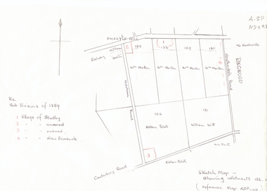
Document, Subdivisions 1859, nd
... Areas near railway line east of Mitcham Station and North East corner of Canterbury and Mitcham Roads. ...canterbury road whitehorse road brunswick road creek road centre road studley village new brunswick village Sketch map of subdivisions of 1859. Sketch map of subdivisions of 1859. Allotment 126 and portions of 125, 126 and 130, including 'Village of Studley', 'Village of New Brunswick' and two unnamed. Information from Mr McComb, retired surveyor; sketch and notes. Areas near railway line ...Sketch map of subdivisions of 1859.Sketch map of subdivisions of 1859. Allotment 126 and portions of 125, 126 and 130, including 'Village of Studley', 'Village of New Brunswick' and two unnamed. Information from Mr McComb, retired surveyor; sketch and notes. Areas near railway line east of Mitcham Station and North East corner of Canterbury and Mitcham Roads. Refer map A - SP 110.Sketch map of subdivisions of 1859.land subdivision, heatherdale road, mitcham, purches street, mitcham road, vermont, canterbury road, whitehorse road, brunswick road, creek road, centre road, studley village, new brunswick village -
Whitehorse Historical Society Inc.
Document, Mines report, 1894
... Mimes Registrar's unpublished report 1894/5913 on inspection along the railway line between Blackburn and Box Hill and on Canterbury Road. Mr Wellington states he obtained colours of gold. ...Signed James Stirling With previous related file papers. miming stirling james Mimes Registrar's unpublished report 1894/5913 on inspection along the railway line between Blackburn and Box Hill and on Canterbury Road. Mimes Registrar's unpublished report 1894/5913 on inspection along the railway line between Blackburn and Box Hill and on Canterbury Road. ...Mimes Registrar's unpublished report 1894/5913 on inspection along the railway line between Blackburn and Box Hill and on Canterbury Road.Mimes Registrar's unpublished report 1894/5913 on inspection along the railway line between Blackburn and Box Hill and on Canterbury Road. Mr Wellington states he obtained colours of gold. Signed James Stirling With previous related file papers.Mimes Registrar's unpublished report 1894/5913 on inspection along the railway line between Blackburn and Box Hill and on Canterbury Road.miming, stirling, james -
 Surrey Hills Historical Society Collection
Photograph, Mrs Elizabeth Cumpston, of Mont Albert
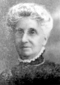
... Surrey Hills Historical Society Collection 190A Canterbury Road Canterbury melbourne Mrs George Cumpston, formerly Miss Elizabeth Newman, of Mont Albert (See also 1289, Mr George William Cumpston) They were married in 1876. He was a commercial traveller. Their property was in the area of Mont Albert between the railway line ...Mrs George Cumpston, formerly Miss Elizabeth Newman, of Mont Albert (See also 1289, Mr George William Cumpston) They were married in 1876. He was a commercial traveller. Their property was in the area of Mont Albert between the railway line and Mont Albert Road and Elgar Road. Listed as living in Box Hill in the 1903 electoral roll. The couple were active members of the Box Hill Methodist Church. Photograph from ‘The Jubilee of Box Hill Methodist Church 1883-1933’. By 1909 they had moved to Hawthorn where they lived form many years; later lived in Kew.A black and white photograph of a lady identified as Mrs G. W. Cumpston. She is wearing glasses and has her hair tied back/up possibly in a 'French roll.'(mrs) elizabeth cumpston, (miss) elizabeth newman, box hill methodist church, (mrs) george william cumpston, mont albert -
 Surrey Hills Historical Society Collection
Photograph, Arthur Lyons of 55 Sunbury Crescent, Surrey Hills
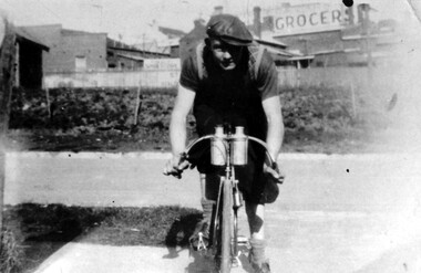
... Surrey Hills Historical Society Collection 190A Canterbury Road Canterbury melbourne Taken outside the Lyons' home in Sunbury Crescent with Union Road shops in the background. It shows the brick substation which stood by the railway gates. The paling fences are along Stirling Crescent, across the railway line ...Taken outside the Lyons' home in Sunbury Crescent with Union Road shops in the background. It shows the brick substation which stood by the railway gates. The paling fences are along Stirling Crescent, across the railway line. Arthur was the only son of Frederick Adolphus Lyons (1891-1980) who was born in Surrey Hills, son of Thomas and Catherine Lyons. He married Elizabeth Ruby Hall in 1918. They lived at 55 Sunbury Crescent. The Lyons’ home was called ‘Knopshambury’ - this was probably a misspelling of Knockshanbally in Co Kilkenny, the birth place of Fred’s father, Thomas Edmund Josias Lyons (1846-1915). Arthur Lyons was born in Surrey Hills on 12 Jun 1920. He became a motor mechanic / welder and lived at 55 Sunbury Crescent. This is one of a series of photos donated by Arthur Lyons. The donation was made while he was in hospital. He died shortly afterwards (23 Sep 1990). Donation was finalised by a neighbour, Mrs Florence Ann Armitstead, wife of Glen Victor Armitstead. Glen was a local hairdresser. They moved to 11 Sunbury Crescent after their marriage in 1939. Arthur had no relatives to distribute the material to.A black and white photograph of a man, with his bicycle. In the background is the railway line and buildings one of which has a sign advertising a grocer.sunbury crescent, surrey hills, stirling crescent, railway line, grocers, (mr) arthur lyons, (mr) arthur frederick lyons, cyclist -
 Surrey Hills Historical Society Collection
Work on paper - Photograph, Canterbury Road, near the corner of Union Road, 1911
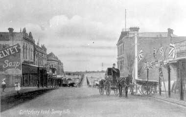
... To begin with, businesses developed along Canterbury Road rather than Union Road, in part because of the muddy nature of the land north of the railway line. canterbury road geer's grocery store surrey family hotel businesses horse drawn vehicle hansen's terrace post card Mr J A Geer On LHS within the original image is 'Canterbury Road, Surrey Hills'; on the rear in top LH corner in blue biro in Jocelyn Hall's handwriting "J H / spare" Black and white photo taken from a postcard of Canterbury Road, near the corner of Union Road, looking west in 1906 or 1907. ...J A Geer's grocery store operated from 1909-1912 on the site established by George Sim in 1884. He bought a house and added a shop where, in 1889, he established the first post office in the area. Prior to this residents had to go the Box Hill to collect mail. Date is approximate.This records one of the earliest businesses in Surrey Hills. To begin with, businesses developed along Canterbury Road rather than Union Road, in part because of the muddy nature of the land north of the railway line.Black and white photo taken from a postcard of Canterbury Road, near the corner of Union Road, looking west in 1906 or 1907. Two children play on the LHS of the street and there is a man on a horse and carriage, and a cart, on the RHS. Buildings on the RHS are the Surrey Family Hotel and J A Geer's grocery store; on the LHS is a row of double-storey terraces including Hansen's Terrace on Canterbury Road to the west of Union Road.On LHS within the original image is 'Canterbury Road, Surrey Hills'; on the rear in top LH corner in blue biro in Jocelyn Hall's handwriting "J H / spare"canterbury road, geer's grocery store, surrey family hotel, businesses, horse drawn vehicle, hansen's terrace, post card, mr j a geer -
 Surrey Hills Historical Society Collection
Photograph, Fred Ambler and Family
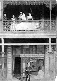
... Canterbury melbourne Fred Ambler and family at Albert Mills Premier Land Agency building on the corner of Union and Sunbury Roads, c.1910. Fred had his carpenter and upholstery business on the ground level and his home above. (No.1) Premier Land Agency Building, was built in 1886-7 by Albert Mills, builder, at 122 Union Road, on the corner of Sunbury Crescent, opposite the Railway Station. Photo shows his wife and family. Alfred died in 1890 and the family moved. The Boroondara Standard in 1888 reported: "Splendid block of brick buildings reaching completion in Union Road adjacent to railway line ...Fred Ambler and family at Albert Mills Premier Land Agency building on the corner of Union and Sunbury Roads, c.1910. Fred had his carpenter and upholstery business on the ground level and his home above. (No.1) Premier Land Agency Building, was built in 1886-7 by Albert Mills, builder, at 122 Union Road, on the corner of Sunbury Crescent, opposite the Railway Station. Photo shows his wife and family. Alfred died in 1890 and the family moved. The Boroondara Standard in 1888 reported: "Splendid block of brick buildings reaching completion in Union Road adjacent to railway line – 2 storey. Frontage 120 feet for Premier Land Agency. Shops at Ground Level." A sepia coloured photograph of a two storey terrace building with 3 ladies and 2 children standing on the balcony. Downstairs, a gentleman stands outside the shopfront beside two prams. There is a child in one pram.albert mills premier land agency building, (mr) fred ambler, union road, carpenter, upholsterer, sunbury crescent -
Canterbury History Group
Photograph - Children's Rally at Canterbury
... Canterbury History Group 190A Canterbury Road Canterbury melbourne Canterbury Canterbury Gardens Railway Lines Maling Road Parades and Processions Childrens Clothing Flags Black and white photograph of Children's Rally at Canterbury. A line ...Black and white photograph of Children's Rally at Canterbury. A line of about twenty children in the Canterbury Gardenscanterbury, canterbury gardens, railway lines, maling road, parades and processions, childrens clothing, flags -
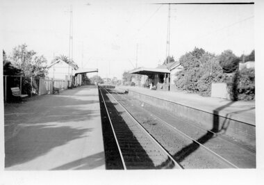
Canterbury History Group
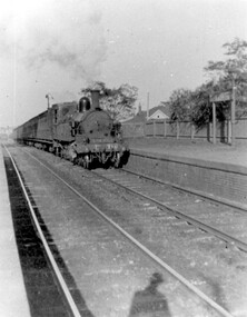
Photograph - Canterbury railway station, c1966
... Canterbury History Group 190A Canterbury Road Canterbury melbourne Canterbury Canterbury Railway Station Canterbury Road Railway Stations Station buildings and line viewed from the north c1966 Black and white photograph Photograph Canterbury railway station ...Station buildings and line viewed from the north c1966 Black and white photographcanterbury, canterbury railway station, canterbury road, railway stations