Showing 51 items matching " east brighton north road"
-
 Glen Eira Historical Society
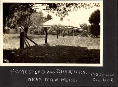
Document - BRIGHTON GENERAL CEMETERY
... ... East Brighton North Road...Cemeteries Brighton Authors Journalists Occupations People Documents Pamphlets Tourist Leaflets Migrants Widowers Knowles Marion Cambridge Ada Buckley Herbert Browne Thomas Alexander Walstab George Alexander Cunningham Edward Sheldon Dow John Lament Dexter Caroline Lynch Caroline Brighton General Cemetery People Associated With Culture Brighton Cemetorians East Brighton North Road People By Circumstance Knowles Joseph Cross George Frederick Ribbledon Herbert Horseracing Equestrian Events Pioneers Squatters Civil Servants Police Boldrewood Rolf Robbery Under Arms The Miner’s Right Babes In The Bush Communication Activities The Age The Herald The Argus Edward Wilson Estate Burketown The Leader Walstab Mary Anne Nolan Anne Jackson Maval Mary Sir Graham Barry Ministry Dow Marion Jane Orr Marion Jane McKenzie David Dexter William Ladies Almanack: The Southern Cross Or Australian Album And New Years Gift Institute Of Hygiene Lynch William Mayors Bombala Cheltenham Pioneer Cemetery Cheltenham Memorial Park Bunurong Memorial Park Cheltenham And Regional Cemeteries Trust Springvale Cemetery Southern Metropolitan Cemeteries Trust Manson Johanna Religious Groups Groups (People) Funerals Cremation Joynt William Donovan Boyd Arthur Peeler Walter Soldiers Armed Forces McCubbin Frederick Casey James Joseph Buckley Maurice Vincent Ogg Charles Catani Carlo Sutton Henry Newland James Ernest Laver Frank Joseph Furphy John Boyd Guy Ballantyre George Frederick Gordon Adam Lindsay McCoy Frderick Higin Batham George Monash John Bent Thomas Miller Septimus Cohen Godfrey Abraham Creswell William Rooke Guilfoyle William Boyd Theodore Penleigh Heinze Bernard Taylor Joseph Leslie Theodore Taylor Squizzy Tritschke Alma Elder James Alexander MacKenzie Breen Marie Boyd William Merrie Boyd Doris Maps East Brighton Hawthorn Road East Brighton Sheffield Road East Brighton Sussex Road Presbyterian Religion Baptist Religion Jewish Religion Roman Catholic Religion Methodist Religion Church of England Anglican Religion Document BRIGHTON GENERAL CEMETERY ...This file contains two brochures from the Brighton General Cemetery, one black and white dated 2013, the other in colour and undated. The first provides eight short biographies of notable writers and journalists interned at the cemetery, the other containing a map with the location of thirty-four notable internments unrelated to literature. Both provide a brief history of the cemetery with the first also including images of some of the people discussed and what appears to be the cemetery emblem. The second brochure displays a colour photograph of a structure in the cemetery.cemeteries, brighton, authors, journalists, occupations, people, documents, pamphlets, tourist leaflets, migrants, widowers, knowles marion, cambridge ada, buckley herbert, browne thomas alexander, walstab george alexander, cunningham edward sheldon, dow john lament, dexter caroline, lynch caroline, brighton general cemetery, people associated with culture, brighton cemetorians, east brighton north road, people by circumstance, knowles joseph, cross george frederick, ribbledon herbert, horseracing, equestrian events, pioneers, squatters, civil servants, police, boldrewood rolf, robbery under arms, the miner’s right, babes in the bush, communication activities, the age, the herald, the argus, edward wilson estate, burketown, the leader, walstab mary anne, nolan anne, jackson maval mary, sir graham barry ministry, dow marion jane, orr marion jane, mckenzie david, dexter william, ladies almanack: the southern cross or australian album and new years gift, institute of hygiene, lynch william, mayors, bombala, cheltenham pioneer cemetery, cheltenham memorial park, bunurong memorial park, cheltenham and regional cemeteries trust, springvale cemetery, southern metropolitan cemeteries trust, manson johanna, religious groups, groups (people), funerals, cremation, joynt william donovan, boyd arthur, peeler walter, soldiers, armed forces, mccubbin frederick, casey james joseph, buckley maurice vincent, ogg charles, catani carlo, sutton henry, newland james ernest, laver frank joseph, furphy john, boyd guy, ballantyre george frederick, gordon adam lindsay, mccoy frderick, higin batham george, monash john, bent thomas, miller septimus, cohen godfrey abraham, creswell william rooke, guilfoyle william, boyd theodore penleigh, heinze bernard, taylor joseph leslie theodore, taylor squizzy, tritschke alma, elder james alexander mackenzie, breen marie, boyd william merrie, boyd doris, maps, east brighton hawthorn road, east brighton sheffield road, east brighton sussex road, presbyterian religion, baptist religion, jewish religion, roman catholic religion, methodist religion, church of england, anglican religion -
Glen Eira Historical Society
Letter - Rosstown Railway
... Road... Melbourne and Brighton Railway... Hawthorn Road... Bambra Road... Caulfield and Frankston Railway... Booran Road... Grange Road... Koornang Road... Murrumbeena Road... North Road... North Road Railway Station... East...Garden Vale Elsternwick Elsternwick Railway Station Rosstown Rosstown Railway Thomas Street Bay Street Kooyong Road Melbourne and Brighton Railway Hawthorn Road Bambra Road Caulfield and Frankston Railway Booran Road Grange Road Koornang Road Murrumbeena Road North Road North Road Railway Station East Brighton Railway Station South Road Railway Routes Railway Lines Railways Land Transport Murphy J. ...This file contains four items: 1/A black and white photocopy of a letter dated either 07/08/1889 or 09/08/1889, from Robert Lundon to an unidentified recipient discussing an agreement reached between the author – on behalf of the recipient – and Soon Hang Hi in regard, in regards to the allotment known as Webber’s. The agreement is outlined in the letter in what appears to be Chinese characters, and includes the marks of Robert Lundon and Soon Hang Hi. File note from Joy Wu states that the calligraphy is not Mandarin or traditional Chinese. 2/Three sheets of hand-written working notes with information taken from the Victorian Government Gazette on THE ROSSTOWN AND MURRUMBEENA LAND COMPANY LIMITED, THE ROSSTOWN JUNCTION RAILWAY AND PROSPERITY COMPANY LIOMITED, and THE ROSSTOWN JUNCTION, ELSTERNWICK, AND OAKLEIGH RAILWAY COMPANY LIMITED, covering dates between 1887 and 1894. The notes concern meetings and creditors claims relevant to the companies, with reference numbers for the information source. Date and author of the notes are not recorded. 3/A black and white photocopy of the a partial map of the Rosstown Railway and surrounding area, undated. The map includes the names of landholders in the areas of Brighton, Garden Vale and Elsternwick, as well as other railway lines present in the region. 4/A fold-out map and guide of the Rosstown Rail Trail, including a brief general history of Caulfield as well as a more extensive biography of William Murray Ross and the Rosstown Railway. The map marks and describes significant sites along the trail, including photographs of some of these sites, provided by DF Jowett.documents, correspondence, webber’s, lundon robert, chinese characters, ethnic communities, signatures, text, settlements, taxes, fraser john grieves, lovell r.h., price davies, meetings, communication activities, soon hang hi, commercial events and activities, the rosstown and murrumbeena land company limited, victorian government gazette, bulmer richard, parry john, osment henry, shareholders, creditors claims, the rosstown junction railway and property company limited, finch and best, lawyers, the rosstown junction elsternwick and oakleigh railway company limited, cameron w.c., phillips p.d., garden vale, elsternwick, elsternwick railway station, rosstown, rosstown railway, thomas street, bay street, kooyong road, melbourne and brighton railway, hawthorn road, bambra road, caulfield and frankston railway, booran road, grange road, koornang road, murrumbeena road, north road, north road railway station, east brighton railway station, south road, railway routes, railway lines, railways, land transport, murphy j., caulfield, hamilton t.f., dane p., holloway, webb, ailee john, payne t.b., brodie chas, dane john, o’neil h., mccombie john, mcmillane a., smyth c.d., cooper, ebden, landholders, jeffrey j.d., gill j., balcombe a.e., cooper h., mcnab j., white j., sutherland j., greeves a.f.a., newton m.c., chamley f.b., fowler j., inglis p., grant t., stooke j., swanson g., cochrane c., adams e.b., mccombie thas, keyes robert, brighton cemetery, burials grounds and graveyards, war-ein road, were j.b., holland j., mcmahon c., winter t.l.m., dendy henry, mitchell w., jackson s., were j.e., wickham francis dawe, bryant jane, east brighton railway station, railway stations, maps, allotments, land titles, roads and streets, rosstown rail trail, city of glen eira, tourism, trains, tourism information bureaus, tours, pamphlets, elsternwick railway park, oakleigh junction, princes park, ee gunn reserve, packer park, sites, jowett d.f., weickhardt i.g., return to rosstown: railways land sales and sugar beet ventures in caulfield, land sales, walking trails, ross william murray, transport objects, locomotion, walking, cycling, driving, sports, country mansions, people, caulfield john, builders, construction and demolition workers, occupations, careers, professionals, topography, geology, landforms, horticulture, market gardens, primary industry workers, city of caulfield, mood kee, pennington harold, annual general meetings, caulfield town hall, glen eira city council, carnegie, carnegie station, rosstown station, people by circumstance, migrants, sugar beet, sugar beet mill, sugar beet industry, mills, factories, sea beach lines, bent thomas, parliamentary representatives, neville street, miller street, lemann’s swamp reserve, koornang park, cane sugar industry, breweries, rabbit processing plants, health establishments, hospitals, food production establishments, abattoirs, thieves, social problems, vagrants, theft, squatting, financial economics, debt, finance industry, insurance companies, company managers, bentleigh, ross leila, the grange, leila road, wild cherry road, financial trouble, mortgages, gisborne street, archibald street, riddell parade, victoria railways, glen huntly road, clarence street, college street, gladstone parade, parrell street, aileen avenue, seaview street, land subdivisions, dover street, sussex street, landfill, marara road, booran road, woodville avenue, dorothy avenue, ormond park, royal avenue, ormond railway station, oakleigh road, melten avenue, miller street, munro avenue, lord reserve, neerim road, toolambool road, the rosstown hotel, rosanna street, murrumbeena crescent, commercial establishments, the national bank, rosstown road, kangaroo road, poath road, freda street, hughesdale kindergarten, oakleigh council, hughesdale community centre, civic establishments, galbally reserve, plaques, warrigal road, out and about brochures, orion estate -
 Glen Eira Historical Society
Document - Melbourne and Metropolitan Board of Works
... Road... Caulfield Intercepting Sewer... Byron Street... Caulfield Park... Elster Creek... Caulfield... Carnegie... Ormond... Bentleigh... Thomas Street... Brighton East... Wheatley Road... McKinnon... City of Caulfield... Bricker G. R.... Walters W. R.... Caulfield City Council... Melbourne and Metropolitan Board of Works... Hall Councillor... Murray Councillor... Murphy Councillor... Wharington Councillor... Phillips Councillor... Blyth Councillor... Best Robert Sir... Reid Doctor... Jowett Mr.... Wooley Mr.... Hindle Mr.... Annual Reports... Water Supply Structures and Establishments... Sewerage and Sanitation... Sewerage Establishments... Drainage... Town Planning... Business and Finance... Councillors... Mayors... Acqueducts... Dams and Reservoirs... Creeks... Waterfalls... Rivers... Construction Sites... North...Road Caulfield Intercepting Sewer Byron Street Caulfield Park Elster Creek Caulfield Carnegie Ormond Bentleigh Thomas Street Brighton East Wheatley Road McKinnon City of Caulfield Bricker G. R. Walters W. R. Caulfield City Council Melbourne and Metropolitan Board of Works Hall Councillor Murray Councillor Murphy Councillor Wharington Councillor Phillips Councillor Blyth Councillor Best Robert Sir Reid Doctor Jowett Mr. Wooley Mr. Hindle Mr. Annual Reports Water Supply Structures and Establishments Sewerage and Sanitation Sewerage Establishments Drainage Town Planning Business and Finance Councillors Mayors Acqueducts Dams and Reservoirs Creeks Waterfalls Rivers Construction Sites North ...This file contains five items relating to Caulfield Council Visits with the Melbourne & Metropolitan Board of Works (MMBW) from 1919 to circa 1974: 1/ A photo album containing photos from the MMBW ‘visit to the Headworks, Yan Yean Water Supply, Wallaby and Silvery Creeks’ from 28/02/1919 to 03/03/1919, attended by members of the Caulfield City Council. The album contains 13 original black-and-white photographs, 3 of which are of the council members. The album is accompanied by a report by Felicitie Campbell, written 11/2008, about these visits. 2/ A publication from the MMBW documenting its review of operations for 1973-1974. The report contains information about water supply, sewerage and drainage infrastructure completed or in progress during this period including infrastructure in Caulfield, Ormond, Carnegie and Bentleigh. 3/ A periodical feature from the MMBW titled ‘Living City’, issue no. 16, Spring/Summer 1974. Included in the article titled ‘Program’ is a notice that construction will continue on the Elster Creek drain from Thomas St. to Wheatley Road, McKinnon. The periodical also includes the names of commissioners W. R. Walters from Caulfield and G. R. Bricker from Moorabbin (back cover). 4/ 2 maps and 1 information booklet from the Thomson Project Open Day attended by Felicite and John Campbell as representatives of the Caulfield City Council. This was an annual MMBW open date. Date unknown. 5/ Research notes by Kate Aldred about the photo album and Thomson Project Open Day booklet and their links to Felicitie Campbell 01/04/2014.koornang road, draper street, hall street, centre road, brewers road, caulfield intercepting sewer, byron street, caulfield park, elster creek, caulfield, carnegie, ormond, bentleigh, thomas street, brighton east, wheatley road, mckinnon, city of caulfield, bricker g. r., walters w. r., caulfield city council, melbourne and metropolitan board of works, hall councillor, murray councillor, murphy councillor, wharington councillor, phillips councillor, blyth councillor, best robert sir, reid doctor, jowett mr., wooley mr., hindle mr., annual reports, water supply structures and establishments, sewerage and sanitation, sewerage establishments, drainage, town planning, business and finance, councillors, mayors, acqueducts, dams and reservoirs, creeks, waterfalls, rivers, construction sites, north road, north road pumping station, cities and towns, campbell felicitie -
 Glen Eira Historical Society
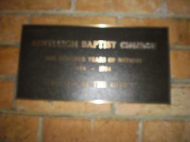
Document - Bentleigh Baptist Church Vickery Street Bentleigh
... East Boundary... North Road... Bentleigh Baptist Church... Brighton...Issues includes a CD with digital photos Reflections reprinted history upon the centenary of Bentleigh Baptist Church 1984 by DL Audemard from May 1985 The Way We Were Feb 1990 pamphlet notes reflections on the churches ministery over the last 50 years by unknown author A brief printed history author unknown and undated on Bentleigh Baptist Church, 10 Vickery Street Bentleigh Two computer generated articles of correspondence between Claire Barton and Robert Bell on the gathering of Bentleigh & Korean Baptist Church history April 2010 Bentleigh Baptist Church Brewer Mr Tucker Road Box Henry Lush GP Rev East Boundary North Road Bentleigh Baptist Church Brighton Baptist Church Tucker Road Church Box Francis Box Edith Clay Jack Clay Joy Lipman Vern Lipman Bronwyn Watt family Pioneers Watt Richard Watt Martha Market gardens Centre Road Jasper Road Watt Herbert Horse drawn vehicles Stamp Mr Hall Annie Vickery Street Watt May Clay family Marriott Hector Watt Don Watt family Box Chris Lipman Joy Grewar family Alexander Chas Shephard F Chapman Samuel Rev Chambers H Eunson TA Rev Boreham E Rev Fletcher W Rev Marriott Hec – market gardens Kennedy Jack Kennedy Lil Kennedy Isa Mary Herron John Seawright Celia Streckfuss Edith Cole Alice Grewar Annie Grewar Hall Faulkner Ern Graham Tom Cross Mabel Cross W Rev Trenches Grewar Jean Ormond Wadley Mr Wellum Mr Hinton WH Rees GP Rev Hinton Mrs Wade Ken Rev Wadley Mrs Bent St Wade Mrs Bell Powell Warner Lawrence Architects Winckel L Rev Richards JL Builders Streckfuss Bert Marriott May Streckfuss family Sach Florrie Sach family Reid Mrs Reid Lesley McMillan Mrs Drapers McKinnon Road Streckfuss Edith Simpson Mrs Wellum Mrs Leadlights Main Mary Evans William John Cooke J Cooke Mrs Cahill Samuel George Smith Kate Freeman Nancy Wanless Mrs Redmore AB Redmore Mrs Audemard Phil Rev Hawkins Margaret Ord Elton Hawkins Shiela Pith Ron Bell Mr Wallace Pat Bell Margaret Audemard Joan Docker Sandra Hubbard Mark Thomas Bernie Thomas Mrs Lamprell Mrs Herron Mr Herron Mrs Freeman Mrs Beach Mrs Paton John Mrs George Lloyd Aspinal Eric Bell Gwen Sutton Mrs Winkel Mrs Neil Mary Costain Mrs Main Mrs Baker Mrs Cross Mrs Kershaw Mrs Smith Millie Smith Jack Freeman Alf Harwood Lindsay Harwood Doreen Bell Lesley Bell Roberta Bentleigh Korean Baptist Church Barton Claire Hoare Mike Hoare Margaret Bott Muriel Bridgeman Pat Cook Don Small Hugh Trewin Bill Smith Eddie Iggulden Sid Neve Keith Horsford David Spencer Wally McEwan Bill Holmes Ron Holmes Joyce Pullman Peter Pullman Elly Probbel Peter Robinson John Bott Laurie Main Alice Disney Clarrie Taylor Kath Woff Miss Rutledge Peter Cameo Playgroup Bentleigh Baptist Church Bentleigh Tucker Road Foundation stones Document Bentleigh Baptist Church Vickery Street Bentleigh ...Reflections reprinted history extracts from Bentleigh Baptist Church Diary from September 1989 to March 1993. Issues includes a CD with digital photos Reflections reprinted history upon the centenary of Bentleigh Baptist Church 1984 by DL Audemard from May 1985 The Way We Were Feb 1990 pamphlet notes reflections on the churches ministery over the last 50 years by unknown author A brief printed history author unknown and undated on Bentleigh Baptist Church, 10 Vickery Street Bentleigh Two computer generated articles of correspondence between Claire Barton and Robert Bell on the gathering of Bentleigh & Korean Baptist Church history April 2010bentleigh, baptist church, brewer mr, tucker road, box henry, lush gp rev, east boundary, north road, bentleigh baptist church, brighton baptist church, tucker road church, box francis, box edith, clay jack, clay joy, lipman vern, lipman bronwyn, watt family, pioneers, watt richard, watt martha, market gardens, centre road, jasper road, watt herbert, horse drawn vehicles, stamp mr, hall annie, vickery street, watt may, clay family, marriott hector, watt don, watt family, box chris, lipman joy, grewar family, alexander chas, shephard f, chapman samuel rev, chambers h, eunson ta rev, boreham e rev, fletcher w rev, marriott hec – market gardens, kennedy jack, kennedy lil, kennedy isa mary, herron john, seawright celia, streckfuss edith, cole alice, grewar annie, grewar hall, faulkner ern, graham tom, cross mabel, cross w rev, trenches, grewar jean, ormond, wadley mr, wellum mr, hinton wh, rees gp rev, hinton mrs, wade ken rev, wadley mrs, bent st, wade mrs, bell powell, warner lawrence, architects, winckel l rev, richards jl, builders, streckfuss bert, marriott may, streckfuss family, sach florrie, sach family, reid mrs, reid lesley, mcmillan mrs, drapers, mckinnon road, streckfuss edith, simpson mrs, wellum mrs, leadlights, main mary, evans william john, cooke j, cooke mrs, cahill samuel george, smith kate, freeman nancy, wanless mrs, redmore ab, redmore mrs, audemard phil rev, hawkins margaret, ord elton, hawkins shiela, pith ron, bell mr, wallace pat, bell margaret, audemard joan, docker sandra, hubbard mark, thomas bernie, thomas mrs, lamprell mrs, herron mr, herron mrs, freeman mrs, beach mrs, paton john mrs, george lloyd, aspinal eric, bell gwen, sutton mrs, winkel mrs, neil mary, costain mrs, main mrs, baker mrs, cross mrs, kershaw mrs, smith millie, smith jack, freeman alf, harwood lindsay, harwood doreen, bell lesley, bell roberta, bentleigh korean baptist church, barton claire, hoare mike, hoare margaret, bott muriel, bridgeman pat, cook don, small hugh, trewin bill, smith eddie, iggulden sid, neve keith, horsford david, spencer wally, mcewan bill, holmes ron, holmes joyce, pullman peter, pullman elly, probbel peter, robinson john, bott laurie, main alice, disney clarrie, taylor kath, woff miss, rutledge peter, cameo playgroup, bentleigh baptist church, bentleigh, tucker road, foundation stones -
 Glen Eira Historical Society
Album - Page 8 of folder D-F, Caulfield Municipality Photo Slide Collection, c.1976 - c.1994
... brighton east...carnegie...caulfield...elsternwick...gardenvale...glen huntly...mckinnon...murrumbeena...ormond...st kilda east...caulfield municipality photo slide collection...roads and streets...north road...Brighton East, Carnegie, Caulfield, Elsternwick, Gardenvale, Glen Huntly, McKinnon, Murrumbeena, Ormond and St Kilda East. Credit: Glen Eira Historical Society - This item was digitised and made available through the Glen Eira Heritage Digitisation Strategy 2019-2023. Glen Eira Historical Society acknowledges the support of Glen Eira City Council. glen eira city council local government caulfield city council caulfield council city of caulfield caulfield contact council services brighton east carnegie caulfield elsternwick gardenvale glen huntly mckinnon murrumbeena ormond st kilda east caulfield municipality photo slide collection roads and streets north road murrumbeena road neerim road queens avenue sports and recreations tennis petrol stations alma road orrong crescent caulfield north east boundary road Page 8 of slide album D to F, in a polypropylene slide sleeve containing 20 x 35mm colour slides. ...The photographs for the slides are believed to have been taken by the inaugural Editor for the Caulfield Contact - the official newspaper of the former City of Caulfield from 1976-1994. The Editor was also Council's Community Liaison Officer and she (and her successor) took many photographs of official events and Council-related services and locations in connection with both these official roles. The City of Caulfield was the Municipal Council for an area of the South Eastern suburbs of Melbourne, including Brighton East, Carnegie, Caulfield, Elsternwick, Gardenvale, Glen Huntly, McKinnon, Murrumbeena, Ormond and St Kilda East. Credit: Glen Eira Historical Society - This item was digitised and made available through the Glen Eira Heritage Digitisation Strategy 2019-2023. Glen Eira Historical Society acknowledges the support of Glen Eira City Council. Page 8 of slide album D to F, in a polypropylene slide sleeve containing 20 x 35mm colour slides. A sample of 7 images from this page is included. glen eira city council, local government, caulfield city council, caulfield council, city of caulfield, caulfield contact, council services, brighton east, carnegie, caulfield, elsternwick, gardenvale, glen huntly, mckinnon, murrumbeena, ormond, st kilda east, caulfield municipality photo slide collection, roads and streets, north road, murrumbeena road, neerim road, queens avenue, sports and recreations, tennis, petrol stations, alma road, orrong crescent, caulfield north, east boundary road -
Glen Eira Historical Society
Document - CUMBERNAULD
... East St. Kilda... Hawthorn Road... ‘Thornleigh Grange’... South Caulfield Progress Association... South Caulfield Junction... Caulfield Court... Jenkins Harry... Giles Alfred... Grafton Street... Elsternwick... Dawes John... Chloris Crescent... St. John’s Presbyterian Church... Mathieson Evelyn Mary... Marks Theodore Leslie... Mathieson Kitty... Masonic Hall... St. George’s Road... Haverfield Frank... Haverfield Mrs... Haverfield Robert Ross... Rynn Mary Buckley... Cyclists... Cycling... Donald Alexander... Martin Lottie... Whitelaw Joan... Trinity Hall... Brighton Road... Gilmore Patricia Phyllis... Brooklyn Ave.... Point Nepean Road... North...East St. Kilda Hawthorn Road ‘Thornleigh Grange’ South Caulfield Progress Association South Caulfield Junction Caulfield Court Jenkins Harry Giles Alfred Grafton Street Elsternwick Dawes John Chloris Crescent St. John’s Presbyterian Church Mathieson Evelyn Mary Marks Theodore Leslie Mathieson Kitty Masonic Hall St. George’s Road Haverfield Frank Haverfield Mrs Haverfield Robert Ross Rynn Mary Buckley Cyclists Cycling Donald Alexander Martin Lottie Whitelaw Joan Trinity Hall Brighton Road Gilmore Patricia Phyllis Brooklyn Ave. Point Nepean Road North ...This file contains nine pages about people related to this property: 1/Copy and pasted eight pages taken from Census Records and Trove items. Articles include the death of Thomas Livingstone Cleland during WWI. Various social notes regarding his family up to 1953. There are articles on the W.J. Mathieson family, who also resided there, as well as residing in Benalla. 2/Print from Trove of an article from the 23/11/1934 edition of The North Eastern Ensign (Benalla, Vic) about the wedding anniversary of Mr and Mrs W.J. Mathieson, held at Cumbernauld on 27/10/1934.cumbernauld, thornleigh grange, house names, cleland thomas livingstone, cleland annie, gardeners market, clayton road, ‘hillside’, caulfield, anderson street, cleland sydney, cleland margaret, cleland james, cleland adelaide, cleland robert, cleland bessie adelaide, cleland agnes, cleland lily, cleland alick douglas milkman, cleland aggie, cleland tom h.s. draftsman, cleland kenneth malcolm, cleland ethel, cleland hector, cleland edna may, mathieson w.j., mathieson isabel, burrows f.a. lieut., east st. kilda, hawthorn road, ‘thornleigh grange’, south caulfield progress association, south caulfield junction, caulfield court, jenkins harry, giles alfred, grafton street, elsternwick, dawes john, chloris crescent, st. john’s presbyterian church, mathieson evelyn mary, marks theodore leslie, mathieson kitty, masonic hall, st. george’s road, haverfield frank, haverfield mrs, haverfield robert ross, rynn mary buckley, cyclists, cycling, donald alexander, martin lottie, whitelaw joan, trinity hall, brighton road, gilmore patricia phyllis, brooklyn ave., point nepean road, north road, brighton court, cleland nora, seaview drive, cleland john stuart, mathieson isabella cristina, kalymna grove, mathieson catherine m., tailor, mathieson william james, councillors, social events and activities, births deaths and marriages, anniversaries, world war 1914-18, soldiers -
Glen Eira Historical Society
Pamphlet - Thomson Memorial Presbyterian Church Ormond
... North Road... Booran Road... Foundation Stone... Thomson Memorial... Presbyterian... Church... Churches... Centre Road... Saint Cuthberts... Flynn John Dr Rev.... Chalinor John P Rev.... Jones Hugh Rev.... Balfour Graham H. Rev.... Beattie James Rev.... Chisholm Farquar Rev.... Hadley Vincent F Rev.... Owen J. E. Rev... George Fincham & Sons... Building Committee... Manse... Home Missionary... Pipe Organ... Thomas Street... Jasper Road... Huntly Street... Brighton East...North Road Booran Road Foundation Stone Thomson Memorial Presbyterian Church Churches Centre Road Saint Cuthberts Flynn John Dr Rev. Chalinor John P Rev. Jones Hugh Rev. Balfour Graham H. Rev. Beattie James Rev. Chisholm Farquar Rev. Hadley Vincent F Rev. Owen J. E. Rev George Fincham & Sons Building Committee Manse Home Missionary Pipe Organ Thomas Street Jasper Road Huntly Street Brighton East ...Two documents about this Church: 1/ a pamphlet titled 'Jubilee - - 1953 - The Jubilee History of the Thomson Memorial Presbyterian Church' that describes the jubilee history of the Church with the history actually dating from 1892. The cover has an illustration of the church and the contents include a list of office bearers in 1953 as well as significant people over the years. Different addresses for it are recorded. 2/ Also a typed page with the description of wording used on the foundation stones at the church (1939) and at the hall (1923).Small paper booklet of 10 pages (beige-coloured) plus front and back cover with a sketch of the church corner of North and Booran Roads Ormond which measures 100mm x 70mm on front cover.presbyterian, ormond, jubilee, north road, booran road, foundation stone, thomson memorial, presbyterian, church, churches, centre road, saint cuthberts, flynn john dr rev., chalinor john p rev., jones hugh rev., balfour graham h. rev., beattie james rev., chisholm farquar rev., hadley vincent f rev., owen j. e. rev, george fincham & sons, building committee, manse, home missionary, pipe organ, thomas street, jasper road, huntly street, brighton east, ulster creek, whitmuir road, merton hall, mulua street, wheatley road, ocean street, cadby hall, plaza theatre, mentone rsl, hadley v.f. rev. b.a. minister, anderson v. mr, box h. mr, curtis r. mr, inglis j. mr, jackson f. mr, lang r. mr, paterson g. mr, ponsford d. mr, porter l. mr, reynoldson a. mr, stevenson d. mr, shallcross h. mr, towers h. mr, viccars r. mr, wade r. mr, williamson w. mr, ponsford d.w. mr, anstee r. mr, box f. mr, mac cleland r. mr, davis a. mr, denton o.w. mr, ferguson a. mr, johnston l. mr, lawrence a. mr, mckerral w. mr, noblet n. mr, sinclair w. mr, taylor s. mr, whitby n. mr, wickenton d. mr, wilson h. mr, warby h. mr, wyatt r. mr, porter lance mr, wade r. mr, wilson d. mr, anderson v. mr, wallace r.a.f. mr, beresford f.j. mr, jackson f. mr, thomson j. mr, henderson a. mr, newham c. mr, arnold a.t. mr, mckerral j. mr, smith e.b. mr, roberts j.h. mr, thomson j. mr, uniting church ormond, 264 booran road, the manse, 428 north road, chinese community, ormond presbyterian church, sutherland family, market gardens, elster creek, sunday schools, malua street, louis r williams architect, norman taylor builder -
 Glen Eira Historical Society
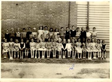
Article - Bentleigh East Primary School
... North Road State School... Ormond State School No 3074... East Bentleigh State School... East Brighton...(Head Teacher) North Road State School Ormond State School No 3074 East Bentleigh State School East Brighton State School No. 2083 Bentleigh State School No 2083 Bentleigh East Primary School No 2083 School 213 Brighton East Bentleigh Elementary School No 2083 Bentleigh West State School No 4318 Coatesville Primary School Tucker Road Moorabbin Primary School Bent Thomas Sir Honor Lists Honour Book Awards Snowball O.R. ...This file contains 5 items. A limited edition of a book "A History of the Bentleigh East Primary School No. 2083 formerly Bentleigh formerly East Brighton 1878-1978" published to mark the centenary of the Bentleigh East Primary School celebrated from 1 – 5th August 1978. The book was compiled by the Principal Peter Morris and is a collection of incidents, reminiscences and anecdotes arranged in chronological order to capture the character of the differing periods through which the school passed. It provides an insight to the development of the area and of the school and includes a list of school principals from 1878 – 1978, an honor roll for WW1 students etc. Notes on the Camm family who donated the School Centenary Book A newspaper article on the centenary celebrations. The article is undated and the source is not known. It includes 2 photographs of the celebrations. A name badge for Duchie Laven issued for the centenary. The badge is on pink cardboard. A Black + White school photograph taken in 1948. Josephine and Wilma Newman are identified in the photograph.malane thomas market gardener, atkinson william – head teacher 1878 – 1883, initial school staff, jack margaret, stevens eliza (pupil teacher), water supply, mills henry (prominent head teacher), craig robert district inspector, centre road, primitive methodist church 22/07/1884, tram lines, taylor mr., head teacher list, shelter sheds., joyce colin dr., thiele mr. (head teacher), north road state school, ormond state school no 3074, east bentleigh state school, east brighton state school no. 2083, bentleigh state school no 2083, bentleigh east primary school no 2083, school 213 brighton east, bentleigh elementary school no 2083, bentleigh west state school no 4318, coatesville primary school, tucker road moorabbin primary school, bent thomas sir, honor lists, honour book, awards, snowball o.r. mla gilbert mr. head teacher, brighton gas lighting, sloyd classes, gilbert mr. (head teacher), cross bob (pupil), school strap, henderson w. (district inspector), school rooms, school work books, schools, school concerts, school committees, caretaker’s residence, fencing, higgins a., higgins stan, bentleigh public hall, marriott william (chairman school committee), bentleigh theatre, old scholars, trenches 1937 (slit), donald j.r. (head teacher), war savings certificates, shelter pavilions, bristol units – classrooms, redmond mr (head teacher), school pedestrian crossings, sound systems, school canteen, world war 1914 – 1918, electricity supply, salmagundi, tamrakis socrates, school libraries, railway stations, education, school rolls, market gardens, cattle – nuisance, bushrangers, toll gates, chinese school, chinese community, school curriculum – historical, flora, aborigines, snakes, migrant teachers, japanese language, rats, caretaker’s residences, fencing, cattle, horse racing, caulfield military hospital, advertising, street lighting, anglican school st stephens, chinese christian church arthur’s seat road (now nepean hwy), st john’s anglican church bentleigh, hit & miss hotel, live & let live hotel, plough & harrow hotel, moorabbin district roads board, army huts, higgins stan mr, . marriott william mr, cremean mr. mla, arnett kevin, vanderlaven vanderlaven adrian, vanderlaven josephine, laven fredericha willamena, laven adrian, laven duchie, newman wilma, newman josephine, camm josephine, marshall gladys, neville gladys, holis ivy, monroe victor, duckmanton keith, tram lines - mordialloc sandringham, school paper, public works dept., springthorpe j.w. dr., vosey joseph, camm terry, camm josie, barrenger elsie, bentleigh oval, race course east bentleigh 1899, keys's hotel, unveiling of honor book and cabinet 25/08/1922 -
Glen Eira Historical Society
Document - BOX FAMILY
... East Brighton... Prahran... Centre Road... Jasper Road... Manchester Road... McKinnon Road... North...Robilliard George James Box Ester Box Fanny (Downard) Box Eleanor Philbrick Richard Fairlam Richard Hale Jasper Dendy Henry Renick Mark Renick Stefanie (nee Riemann) Brighton Cemetery Ormond East Brighton Prahran Centre Road Jasper Road Manchester Road McKinnon Road North Road Brighton Box Cottage Moorabbin Historical Society Thomas Street Elsternwick Paterson Road East Bentleigh Tucker Road Jasper Road Harwood Thomas Box Violet Hordeen Lebbens Augustus Arthur Wattle Pioneers Ancient Order of Foresters Council of Moorabin Elster Creek Primitive Methodist Church Lewis’ Timber Yard Grape Growing Paling House Wells Water Wagon Market Gardens Farming Aboriginal People King Billy Chinese Kayon (?) ...Extensively detailed family history from 1838 in UK to present day. Provides much local history and social history into early pioneering and market gardening families. Forty one page computer print out with numerous black and white photographs.box w.h. george, box george, box mary nee cripps, box caroline, box william, box henry, box john, box anna, box eliza, box elizabeth nee avis, box francis, box lydia, moeller a., mclean n., robilliard george james, box ester, box fanny (downard), box eleanor, philbrick richard, fairlam richard, hale jasper, dendy henry, renick mark, renick stefanie (nee riemann), brighton cemetery, ormond, east brighton, prahran, centre road, jasper road, manchester road, mckinnon road, north road, brighton, box cottage, moorabbin historical society, thomas street, elsternwick, paterson road, east bentleigh, tucker road, jasper road, harwood thomas, box violet, hordeen lebbens, augustus arthur, wattle, pioneers, ancient order of foresters, council of moorabin, elster creek, primitive methodist church, lewis’ timber yard, grape growing, paling house, wells, water wagon, market gardens, farming, aboriginal people, king billy, chinese, kayon (?), kay you (yu?), cheong ki, boxer rebellion, chinese missionary, brickmakers, midwife, corben’s monumental masons, sculptor, cottage, parlour, verandah, scullery, le man’s swamp, flower nursery, chook houses, ladies college, moorabbin roads board, western market, eastern market, victoria market, st. kilda road, nepean road/highway, mckinnon, ormond, carnegie, oakleigh, murrumbeena, moorabbin, mordialloc, heathcote, bentleigh, brighton east, manchester road, brighton council, city of moorabbin, west joseph, porter harriet, moore henry, moeller a (moller), box mary, lindsay mccurry elizabeth, lindsay elizabeth, lindsay henry, lindsay frederick, schmidt william, robilliard james cpt., beckett ida, beckett nellie, beckett martha, beckett martha maud, robinson eleanor, robinson joyce, dowling thomas, anderson william snowden, mccurry henry mr & mrs, box emily jane (nee mccurry), jorgensen justin, jorgensen dr., jorgenson bertha, ross william murray, st. kilda, merrie creek, pentridge (now coburg), murray road, wyuna dunoos st, grange road, rosstown, tucker rd, elizabeth st, common school no 213 east brighton, bentleigh, steel roads tracks, rabbits, cheltenham, brighton cemetery, cheltenham cemetery, paterson road, east boundary road, baptist church, lay preachers, missionaries- china, oakleigh tyre works, belfast hotel sandhurst (bendigo), mornington, gas street lighting, brighton historical society, moorabbin primary school, bravis road, lewis street, chalmers street, grange road, butcher shops, ormond state school, oakleigh council, wedding dress, methodist children’s home cheltenham, bentleigh baptist church, auctioneer, lindsay mark, balkham jane, balkham stephen, reitman august william, fitzwilliam catherine, quashdorf (?phonetic) mr, box violet, montford paul, reitman stephanie (renick mrs), reitman william, box ada, downard alicia (lill), downard arthur, downard edward, graham elizabeth, downard octavia rose, downard william alfred, downard arthur henry (harvey), downard fanny, thompson eliza jane, box lena caroline, viloudaki rebecca, box anna (pay), pay henry, box eliza (gurr), johnson geoffrey, rushall eleanor (nellie), gurr eliza nee box, gurr jabez henry tasman, marriot william mrs, ross william murray, box gladys (nee battersby), box dulcie (bussell), bussell samuel robert, bussell norma (hoult), bussell darren lyle, bussell craig andrew, bussell sylvia june (barry), barry j. haydon, barry rachael alexandra, barry phillipa anne, barry vanessa kate, bussell joan lorraine (millie), millie john, bussell harold leslie, euston mr, purdue edgar robert, box lydia elizabeth, wilkinson coral doreen, mitchell donald, centre road, court pride of st george aof, dunoon street, vickery street, darey street/ave., oakleigh state school, methodist church, mill street, koornang road, regent street, marriage road, box olivia christina, box ernest charles, box walter william, lawson robert, lawson nancy eunice (curtis), box walter stanley, box eleanor (nellie) rushall, box martha, box john, box nellie gladys, andrews william (bill), box ray, mccurry mrs elizabeth, box william henry george, schreiber family, jorgensen family, downward arthur, downward alicia – lill, downward octavia rose, downward william alfred, downward arthur henry/harvey, cummings ida, cummings william, downward alice (nee cleary), downward ada, downward lucy (mrs bailey), downward alice, downward arthur harvey, bailey lawrence, bailey ian, bailey carol viola (bartlett), bailey colin harvey, bailey julie alison (hardware), bailey val, bailey adina, bailey david, bartlett brian, bartlett bradley grant, bartlett clayton lawrence, hardware michael, hardware dion michael colin, hardware jevon michael bailey, box elanor, box alice amelia (dale), dale george, dale elizabeth, dale lilly, dale john, dale thomas, dale rose, dale ethelbert, dale george, dale elsie, box thomas henry, box annie lavinia (rogers), rogers annie elizabeth, rogers william richard, box arthur walter, nelson dagma marie (box), box walter kingston, box marie, box cecilia eliza (ainger), ainger james, box ida may, cumming william george, cumming wendy (nee mansell), cumming susan, cumming paul, cumming felicity (steel), cumming shane, cumming melissa, cumming angel, box harold, box dorothy may (jackson), jackson frederick, jackson margaret (walker), jackson judith, walker david, walker michelle (neville), neville andrew, walker darren, walker rebecca (coyne), walker joshua, walker bradley, johnson steven, johnson carl, johnson judith (jackson), johnson peter, johnson melissa (hamid), johnson craig, ely johnson/jackson judith, ely steven, linham arthur, box thelma elizabeth (eagle), eagle keith, eagle nancye elizabeth (harpin), harkin john, harkin mary anne (howe), howe barry, howe samuel, harkin michael, harkin christopher, harkin elizabeth, eagle roddan, eagle carolyn (mansell), eagle gerard, eagle kerri – lee, box avis ann (eldridge), eldridge alf, eldridge robert, eldridge sandra, eldridge adam, eldridge nicholas, eldridge patric, eldridge john, eldridge carol (biggs), eldridge robert james, eldridge catherine elizabeth, eldridge meredith, box william john, box maud (nee hanchette), box malcome, box sandra (ede), box stephen, box nicolle, box andrew, box christine (dormer), box corrina, box jennifer (turpin), turpin phillip, box herbert, box olwyn (richard), box elaine henry, henry bruce, henry james, henry robin, henry david, box richard, box nerida (bowen), box duncan, box john, box cerwiden, box ewan, box bryan, box collen (malony), box kieran, box eden, box christopher, box pam (smith), box sue (tirchett), box thomas, box william, box george frederick, box olive (cameron), box eliza jane (thompson), box francis george, box lena caroline, box-hembrow mable alma, box charles francis, clinch mr., box robinson jessie melinda, box clay edith florence, north brighton, waun alex, waun robert, marquis peter, sheppard w., warnbach mr, marriott william mrs, box dorothy (seabrook), box hazel, box jessie, box frank (francis), seabrook len, box henry, seabrook albert, seabrook stanley allan, barry j. haydon, barry rachel alexandra, millie john, bussell harold leslie, bussell sue, bussell leanne melinda, bussell benjamin leslie, bussell lynette, box george, box jean (holms), box george, box alisa (hughes), hughes justin, hughes ebony, hughes tasman, box robin, box veronica (roman), box andrea roman, box lisa roman, box jodi roman, box malcome, box sue (kerrison), box amanda, box anthony, clay john (jack) francis, clay lynda blanche (nee sibte), clay vivien, clay majory joy, lipman vernon (vern) ronald, clay kenneth graham, clay laura jean -
Glen Eira Historical Society
Article - St Peter's Catholic Church, Bentleigh East
... Brighton – St Kilda Mission... Niall Patrick William FR... Dendy Henry... Guiney John MR... King Richard... King John... Keys George... O’ Shanassy John... Keys Robert... Were Jonathan B.... O’ Connell John FR... Glass Hugh MR... O’ Farrell Peter... Brady Peter... Kennedy James... Boland Michael... McCormick Francis... Orrong Road... Little Brighton... Oakleigh... Port Phillip Bay... East Boundary Road... North...O’ Connell John FR Glass Hugh MR O’ Farrell Peter Brady Peter Kennedy James Boland Michael McCormick Francis Orrong Road Little Brighton Oakleigh Port Phillip Bay East Boundary Road North Road Ormond Old Dandenong Road Mordialloc Creek Moorabbin Springvale No Good Damper Road Kingstown Keysborough Bignell Road South Road Heatherton Big Brighton Gardenvale Elsternwick Brady Road Jasper Road Chesterville Road Cochrane Road McGuinness Road H.A.C.B.S. ...Included In The File is A Newspaper Clipping From The Age Newspaper, Dated Sat 09/11/1974 On The Opening Written By Stuart Sayers. The Article Mentions A Brief History Of The Church & School Beginnings & The Opening Ceremony. There Are Two Copies Of The Living Harvest (One Without The Cover), The Book Gives A Detailed History Of St Peter's Catholic Church, Bentleigh East Written By W.T. Dobson And Published in 1974. From The First White Settlers, The Irish Exodus, And The Irish Catholic families, The School House And The History Of The Parish & Clergy Up To 1974.st peter's catholic church, niall patrick rev, emerald hill, bentleigh east, dobson w. t., yarra, moorabbin, heriot m. b., elsternwick, north road, quinn fred, bentleigh, centre road, kennedy james joseph, melbourne south, bignell road, kennedy market garden, oakleigh, st peter's parish, st james parish, the living harvest, catholic church, hibernian society, bavarian brass band, st peter's primary school, st james regional college, brighton catholic school, brighton – st kilda mission, niall patrick william fr, dendy henry, guiney john mr, king richard, king john, keys george, o’ shanassy john, keys robert, were jonathan b., o’ connell john fr, glass hugh mr, o’ farrell peter, brady peter, kennedy james, boland michael, mccormick francis, orrong road, little brighton, oakleigh, port phillip bay, east boundary road, north road, ormond, old dandenong road, mordialloc creek, moorabbin, springvale, no good damper road, kingstown, keysborough, bignell road, south road, heatherton, big brighton, gardenvale, elsternwick, brady road, jasper road, chesterville road, cochrane road, mcguinness road, h.a.c.b.s., school house, st patrick's church, brighton parish, denominational school, little brighton school, moorabbin catholic school, temporary chapel, st james regional college, sister of mercy, lanigans ball, east brighton public hall company ltd, east bentleigh hall, messrs. robert dunn & son, bavarian brass band, st joan of arc parish, east bentleigh parish, the sisters of our lady of sacred heart, the anchor club, mccormick cornelius, cochrane james, cochrane david, mcguinness margaret, cormick john, cahill james, quinn frederick, prendegast john patrick, naughton dennis, leary william, charlston john, carey matthew fr, gibbons patrick, kennedy joseph james, o’ sullivan tim fr, mckenna fred fr, casey william fr, browne joseph fr, crawford mal fr, hanrahan mr, gillon rose miss, sampson kate mrs, horan miss, coakley daniel fr, dillon kevin fr, whitehouse ray fr, mannix daniel dr, dobson william mr, gahan patrick, hallinan thomas, delaney john, fitzgerald patrick, st peter's catholic church -
Glen Eira Historical Society
Plan - Nettalie
... North... Elsternwick... St Kilda East... Parish of Prahran... Parish of Moorabbin... Caulfield Road District... Melbourne and Brighton...Roads where Nettalie is situated. The plan includes all the landowners listed where their property was, the street names and other landmarks of 1867 including railways, hotels and reserves. Caulfield Caulfield North Elsternwick St Kilda East Parish of Prahran Parish of Moorabbin Caulfield Road District Melbourne and Brighton Railway Rosstown Railway Elsternwick Railway Station Caulfield Railway Station Rosstown Railway Station Murrumbeena Railway Station Baptist Church Paddy’s Swamp reserve Cemetery Reserve Leman Swamp Reserve Caulfield Racecourse Reserve Brighton Cemetery The Vine Caulfield Hotel The Tam O’Shanter Hotel Melbourne Hunt Hotel Royal Hotel Hotham Street Horne Street Nepean Highway North Road Orrong Road Dandenong Road Princes Highway Kooyong Road Alma Road Inkerman Road Balaclava Road Glen Eira Road Glen Huntly Road Hawthorn Road Cemetery Road Bambra Road Redan Road Kambrook Road Neerim Road Booran Road Racecourse Road Grange Road Koornang Road Murrumbeena Road Crosbie Road Kangaroo Road Poath Road Ford W Lempriere Cople J Riddell J C Manifold J Testar T Billing R H Semple Blundell Shaw A Butchart G Stephen J W Stephen G Sir Hart J Duncan G Blackie R Stephen F McCombie T Woollaston H Higgins J Lloyd J C Daish J McLeod J Hughes D Wilson A Jamieson G Webb G H Renwick S Pennington H Dunn J Kirkpatrick W Ricketson W Toad A Sayce J Watts T Widgery Store Guess J Anketell J Clack J Sissen W Clayton G Dickson D Bevan J Hart T Anderson J Hart Mrs Webb H Masters S Waghorn J Hemming C Hiam C Farquhar W Newing T Payne T Cooper R Snipe S Chambers J Forster W Summers R Harriman B Warrick O’Connell Long J Peck R Cochrane C Murray Ross W Evans C Kennedy J Maclean N Forster Lyall W Dean J Newton H Looker W Baker C Johnston Crosbie J Kerr Jones Parr Nelson C Montgomery L Parsons W James J C Sibon C Smith Sydney W Plans Maps Land subdivisions Land use Settlements Roads and streets Hotels Churches Police stations Post offices Land surveys Railway stations Railways Schoolhouses Commerce Clergy residences Official buildings Local government Road districts Plan Nettalie ...An A4 photocopy of the 'Plan of the Caulfield Road District' dated 1867. This plan shows the location of the properties owned by A Shaw and Blundell on Balaclava and Orrong Roads where Nettalie is situated. The plan includes all the landowners listed where their property was, the street names and other landmarks of 1867 including railways, hotels and reserves.caulfield, caulfield north, elsternwick, st kilda east, parish of prahran, parish of moorabbin, caulfield road district, melbourne and brighton railway, rosstown railway, elsternwick railway station, caulfield railway station, rosstown railway station, murrumbeena railway station, baptist church, paddy’s swamp reserve, cemetery reserve, leman swamp reserve, caulfield racecourse reserve, brighton cemetery, the vine caulfield hotel, the tam o’shanter hotel, melbourne hunt hotel, royal hotel, hotham street, horne street, nepean highway, north road, orrong road, dandenong road, princes highway, kooyong road, alma road, inkerman road, balaclava road, glen eira road, glen huntly road, hawthorn road, cemetery road, bambra road, redan road, kambrook road, neerim road, booran road, racecourse road, grange road, koornang road, murrumbeena road, crosbie road, kangaroo road, poath road, ford w, lempriere, cople j, riddell j c, manifold j, testar t, billing r h, semple, blundell, shaw a, butchart g, stephen j w, stephen g sir, hart j, duncan g, blackie r, stephen f, mccombie t, woollaston h, higgins j, lloyd j c, daish j, mcleod j, hughes d, wilson a, jamieson g, webb g h, renwick s, pennington h, dunn j, kirkpatrick w, ricketson w, toad a, sayce j, watts t, widgery, store, guess j, anketell j, clack j, sissen w, clayton g, dickson d, bevan j, hart t, anderson j, hart mrs, webb h, masters s, waghorn j, hemming c, hiam c, farquhar w, newing t, payne t, cooper r, snipe s, chambers j, forster w, summers r, harriman b, warrick, o’connell, long j, peck r, cochrane c, murray ross w, evans c, kennedy j, maclean n, forster, lyall w, dean j, newton h, looker w, baker c, johnston, crosbie j, kerr, jones, parr, nelson c, montgomery l, parsons w, james j c, sibon c, smith sydney w, plans, maps, land subdivisions, land use, settlements, roads and streets, hotels, churches, police stations, post offices, land surveys, railway stations, railways, schoolhouses, commerce, clergy residences, official buildings, local government, road districts -
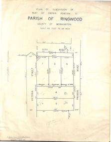 Ringwood and District Historical Society
Document - Folder, Plan of Subdivision - Part of Crown Portion 11, Parish of Ringwood - undated, circa 1950s
... Ringwood and District Historical Society 125A Warrandyte Road Ringwood North melbourne (Surveyor) R. James Love L.S. M.I.S. (Aust) M.A.I.C. 52 Comer Street Brighton East S6 Phone XB-5928 Buff coloured survey map of subdivision glued to manilla folder. ...Buff coloured survey map of subdivision glued to manilla folder. Five residential blocks bounded by City Road, Victoria Street (later Ireland Street), and Prussia Road (later Regina Street).(Surveyor) R. James Love L.S. M.I.S. (Aust) M.A.I.C. 52 Comer Street Brighton East S6 Phone XB-5928 -
 City of Moorabbin Historical Society (Operating the Box Cottage Museum)
Photographs,x3 Colour Early Weatherboard Cottage Cheltenham c1880, 1981
... Henry Dendy , a farmer from Sussex England, purchased 5,120 acres of land in the area of a 'Special Survey 1841' that extended from Brighton bayside North Road, East Boundary Rd to South Road. ...City of Moorabbin Historical Society (Operating the Box Cottage Museum) Joyce Park Jasper Road Ormond melbourne Henry Dendy , a farmer from Sussex England, purchased 5,120 acres of land in the area of a 'Special Survey 1841' that extended from Brighton bayside North Road, East Boundary Rd to South Road. ...Henry Dendy , a farmer from Sussex England, purchased 5,120 acres of land in the area of a 'Special Survey 1841' that extended from Brighton bayside North Road, East Boundary Rd to South Road. This area became known as Dendy's Brighton and as part of the sale 139 emigrant workers arrived in 1842 however Dendy was unable to find work and lodgings for these people. J.B.Were, financier took over the management of the 'Special Survey 1841' area and began to sell and lease allotments. 1850 the Squatter King brothers sold land south of Dendy's 'Special Survey 1841' to Josiah Holloway who sectioned it into 2 acre lots @ £10 each for market gardens - 'Two Acre Village' and Charles Whorral opened a small hotel - 'The Cheltenham Inn' on the main Road - Arthur's Seat Rd, later Point Nepean Rd, now Nepean Highway. Notable settlers who moved into the area were Keys, Charman, Bruton, Le Page, Fairlam, Meeres and 1862 saw the separation from Brighton and the formation of the Mooorabbin Roads Board District. .By 1879 1000settlers were living in 'Cheltenham' serviced by a Post Office with Bank, Mechanics Institute, State School No 84,Keys Hotel, Meeres Store, Sir Thomas Bent ensured the new Railway Line from Caulfield to Mordialloc went through his constituency of Cheltenham 1881 and this changed the development to the bayside area of Cheltenham away from the 'Two Acre Village ' side causing some dissention, However Cheltenham as whole prospered and this house in Pine St is typical of the cottages built c 1890- 1900 in the area. This weatherboard house c 1890-1900 in Pine St Cheltenham is typical of those built for early settler families. Photo taken 1981 by CMHS member 3 x Colour photographs of an early c 1900 weatherboard house in Pine St Cheltenham taken by CMHS member 1981Kodak Aug. 81 / Handwritten Pine St Cheltenhamkeys robert, holloway josiah, king brothers, smith j l; smith mary ann, stanley helen, chaff cutter, horse drawn carts, toll gates brighton, motor cars 1900, steam engines, early settlers, bentleigh, parish of moorabbin, city of moorabbin, county of bourke, moorabbin roads board, shire of moorabbin, henry dendy's special survey 1841, were j.b.; bent thomas, o'shannassy john, king richard, charman stephen, highett william, ormond francis, maynard dennis, market gardeners, vineyards, orchards -
 City of Moorabbin Historical Society (Operating the Box Cottage Museum)
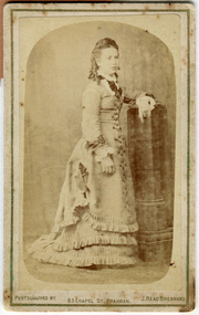
Photograph, B&W, Martha Sheldrake 1st wife of John Box, c1880
... John Box was a pioneer market gardener in North Road, East Brighton now Bentleigh. He married Martha Louise Sheldrake and they had 10 children. ...John Box 1841 - 1914, the 4th son of George and Mary Box, was born in Withyham, Sussex England and came to Australia in 1856 with his parents. He lived and worked on his fathers market garden in East Brighton ( now Bentleigh) for several years and then rented a property in Tucker Road in 1862. John married Martha Sheldrake and they had 10 children who were all born in East Brighton ( now Ormond ). Their eldest daughter Rebecca 'Faith' Box 1863 -1950 was a member of the 1st Australian party to go to China with the Methodist Church China Inland Mission in 1890. During the Boxer Rebellion 1900-1901 Rebecca was rescued from her inland mission post by a group of traders from Shanghai. She later married Nicolas Viloudaki, a Greek Silk merchant , who was a member of the rescue party. Rebecca sent a bolt of chinese hand embroidered cream silk to Mary Closter for her wedding dress at her marriage to Alonzo Box, who was Rebecca's younger brother. This Dress has been published on the Australian Dress Register in 2015 and is on display at Box Cottage Museum Ormond. John Box is the brother of William Box who, with his wife Elizabeth Box, lived in Box Cottage . John Box was a pioneer market gardener in North Road, East Brighton now Bentleigh. He married Martha Louise Sheldrake and they had 10 children. The eldest daughter Rebecca was a Methodist Missionary in China and Alonzo, their 9th child, served in the Army WW1 at Gallipoli, France and Flanders. Rebecca sent the hand embroidered Chinese silk material for the Wedding Dress worn by Mary Closter at her marriage to Alonzo Box 1918. After Martha died John Box married Eleanor Rushall c 1900 and they had 3 children. John was well respected by the community and also a Methodist lay preacher. Box Cottage Museum, a reconstruction of an early settler hut, is named after the Box family who resided there 1865 -1913 . William Box who, with his wife Elizabeth Avis Box and 13 children, lived and farmed on the block of land in Jasper Road, East Brighton ( now McKinnon / Ormond) that was part of the Henry Dendy Special Survey 1841. Inscribed in Album “ The early photos in this album were found by Mr (Laurie) Lewis when he was demolishing the Old Box Cottage. He gave them to Mrs Avis Box Eldridge who in turn gave them to me. They were not identified. I believe they rightly belong in the Cottage. I have attempted to identify them and present them in a way they can be preserved as a historical record of the era.” A B Leigh A black and white photograph of Martha Sheldrake d1895 the 1st wife of John Box 1841-1914Photographed by J Read Brennand / 83 Chapel St. Prahran -
 City of Moorabbin Historical Society (Operating the Box Cottage Museum)
Newsletter, City of Moorabbin Historical Society Feb 2009, February 2009
... brighton estate...moor henry...cambden estate...reitman j....reitman w....cement...pottery...jasper road ormond...east boundary road brighton...dendy’s special survey 1851...point nepean road...south road brighton...thomas street brighton...north...Tom Sheehy, past President of CMHS, was an Historian and Author of ‘Battlers Tamed the Sandbelt’. city of moorabbin historical society stanley helen sheehy tom melbourne moorabbin brighton cheltenham ormond bentleigh vineyards fruit growing vine diseases winemaking grapes market gardeners pioneers early settlers moorabbin shire box cottage museum dairy port phillip bay brighton estate moor henry cambden estate reitman j. reitman w. cement pottery jasper road ormond east boundary road brighton dendy’s special survey 1851 point nepean road south road brighton thomas street brighton north road brighton county of bourke box h. box william bruton william brighton brewery parish of moorabbin parish of prahran markets shingle roof weather-board downward mr. mckinnon CITY of MOORABBIN HISTORICAL SOCIETY / FEBRUARY 2009 NEWSLETTER 2 x A4 paper printed on 3 sides Issue 10 of the bi-monthly, City of Moorabbin Historical Society Newsletter produced by Society member and Secretary, Mrs Helen Stanley in February 2009. ...The City of Moorabbin Historical Society was formed c 1960 by a group of Moorabbin residents who were concerned that the history of the area should be preserved. A good response to a call for items related to the historical area of Moorabbin Shire brought donations of a wide variety of artefacts which are now preserved by the current members of CMHS at Box Cottage Museum . Helen Stanley, Secretary of CMHS, began producing a Newsletter for members in April 2007 to provide current information and well researched items of historical interest.Helen Stanley has produced a bi-monthly Newsletter, 2007 - 2013, for the members of the City of Moorabbin Historical Society that contains well researched interesting historical items, notification of upcoming events, current advice from Royal Australian Historical Society , Museums Australia Victoria and activities of Local Historical Societies. The Newsletter is an important record of the activities of the CMHS. Tom Sheehy, past President of CMHS, was an Historian and Author of ‘Battlers Tamed the Sandbelt’. 2 x A4 paper printed on 3 sides Issue 10 of the bi-monthly, City of Moorabbin Historical Society Newsletter produced by Society member and Secretary, Mrs Helen Stanley in February 2009. The Victorian Bushfire tragedy around Marysville is still unfolding as this Newsletter is written. The first meeting for the year is February 22nd and subscriptions are due. An excerpt is transcribed from the City of Moorabbin Historical Society Newsletter October 1962, “A Piece of History in Ormond” by an unknown eyewitness author, describing the original “Box Cottage” situated in Mr J. Reitman’s cement products factory at 306 Jasper Road, Ormond prior to demolition. The current Editor gives information obtained from further recent research . An Article by Tom Sheehy, past President and Historian, February 1979 “The Vineyards of Moorabbin”. The ‘Brighton Estate” began when Henry Moor brought Vine cuttings from Camden NSW 1848 and they were productive after 3 years. Many Vineyards then appeared from Port Phillip Bay to East Boundary Road and produced 2/3 of the annual Victorian grape crop. Disease or insect caused failure in1858 and the land reverted to market gardens. A coloured photocopied photo of Box Cottage 2005. CITY of MOORABBIN HISTORICAL SOCIETY / FEBRUARY 2009 NEWSLETTERcity of moorabbin historical society, stanley helen, sheehy tom, melbourne, moorabbin, brighton, cheltenham, ormond, bentleigh, vineyards, fruit growing, vine diseases, winemaking, grapes, market gardeners, pioneers, early settlers, moorabbin shire, box cottage museum, dairy, port phillip bay, brighton estate, moor henry, cambden estate, reitman j., reitman w., cement, pottery, jasper road ormond, east boundary road brighton, dendy’s special survey 1851, point nepean road, south road brighton, thomas street brighton, north road brighton, county of bourke, box h., box william, bruton william, brighton brewery, parish of moorabbin, parish of prahran, markets, shingle roof, weather-board, downward mr., mckinnon -
 City of Moorabbin Historical Society (Operating the Box Cottage Museum)
Newsletter, City of Moorabbin Historical Society Apr 2009, April 2009
... brighton estate...jasper road ormond...east boundary road brighton...dendy’s special survey 1851...point nepean road...south road brighton...thomas street brighton...north...Peter’s Catholic School East Bentleigh 1865 on land donated by Fred Quinn , in Centre Road, East Brighton ( East Bentleigh). A photo copy of Parts of Country Portion 39 of Dendy’s Special Survey or Brighton Estate showing the Land Sales of Lot 2, & 3 North Road and Jasper Road 1841 – 1869. ...Peter’s Catholic School East Bentleigh 1865 on land donated by Fred Quinn , in Centre Road, East Brighton ( East Bentleigh). A photo copy of Parts of Country Portion 39 of Dendy’s Special Survey or Brighton Estate showing the Land Sales of Lot 2, & 3 North Road and Jasper Road 1841 – 1869. ...The City of Moorabbin Historical Society was formed c 1960 by a group of Moorabbin residents who were concerned that the history of the area should be preserved. A good response to a call for items related to the historical area of Moorabbin Shire brought donations of a wide variety of artefacts which are now preserved by the current members of CMHS at Box Cottage Museum . Helen Stanley, Secretary of CMHS, began producing a Newsletter for members in April 2007 to provide current information and well researched items of historical interest.Helen Stanley has produced a bi-monthly Newsletter, 2007 - 2013, for the members of the City of Moorabbin Historical Society that contains well researched interesting historical items, notification of upcoming events, current advice from Royal Australian Historical Society , Museums Australia Victoria and activities of Local Historical Societies. The Newsletter is an important record of the activities of the CMHS.2 x A4 paper printed on 4 sides Issue 11 of the bi-monthly, City of Moorabbin Historical Society Newsletter produced by Society member and Secretary, Mrs Helen Stanley in April 2009. Notice that Mr Travis Sellars, Friends of Cheltenham and Regional Cemeteries, will talk about ‘The Tragic 20’s’ at the meeting April 26th . Volunteers are needed to show visitors around on Open Days each month and a Roster will be made on April 26th . Suggestions are requested for the Community Grant Application to be submitted by CMHS. Historical details are condensed from ‘ The Living Harvest’ by W.T Dobson, describing the establishment of St. Peter’s Catholic School East Bentleigh 1865 on land donated by Fred Quinn , in Centre Road, East Brighton ( East Bentleigh). A photo copy of Parts of Country Portion 39 of Dendy’s Special Survey or Brighton Estate showing the Land Sales of Lot 2, & 3 North Road and Jasper Road 1841 – 1869. Interesting note on the origin of ‘Jasper Road’. 3 photocopied photographs of St Peter’s School building 1903, School Children at East Brighton Railway Station, 1903, A Lorry in the parade 1903. CITY of MOORABBIN HISTORICAL SOCIETY / APRIL 2009 NEWSLETTERcity of moorabbin historical society, stanley helen, dobson w.t., melbourne, moorabbin, brighton, friends of cheltenham and reional cemeteries, cheltenham, ormond, bentleigh, market gardeners, irish immigrants c1850pioneers, early settlers, moorabbin shire, box cottage museum, port phillip bay, brighton estate, jasper road ormond, east boundary road brighton, dendy’s special survey 1851, point nepean road, south road brighton, thomas street brighton, north road brighton, county of bourke, box h., box william, parish of moorabbin, parish of prahran, markets, shingle roof, weather-board, mr., mckinnon, were jonathan, niall rev. fr. patrick, quinn fred, elsternwick, catholic church directory 1878, hibernian society melbourne, brady peter., kennedy mr., boland mr., leary mr., gahan mr., archbishop carr, rev. fr. gough., presentation convent gardenvale, sister mary vincent, charlston john, bavarian dress band, hales jasper -
 City of Moorabbin Historical Society (Operating the Box Cottage Museum)
Newsletter, City of Moorabbin Historical Society June 2009, June 2009
... Jasper Hale , transported for theft, earned his ‘Ticket of Leave, and purchased land in Dendy’s Special Survey of 1841 later known as East Bentleigh. city of moorabbin historical society stanley helen rigby jan melbourne moorabbin brighton cheltenham ormond bentleigh market gardeners pioneers early settlers moorabbin shire box cottage museum jasper road ormond dendy’s special survey 1851 north road brighton county of bourke box h. box william parish of moorabbin were jonathan hales jasper port jackson penal colony burgess s. william kemble wiltshire england stonemason bricklayer ‘york’ sailing ship brummell mary st. mary’s catholic church sydney nelson mary ann ‘george hibbert’ sailing ship hale james hale eliza parkes new south wales gold rush ballarat gold rush clunes gold rush forbes nsw gold rush parkes historical society CITY of MOORABBIN HISTORICAL SOCIETY / JUNE 2009 NEWSLETTER 2 x A4 paper printed on 3 sides Issue 12 of the bi-monthly, City of Moorabbin Historical Society Newsletter produced by Society member and Secretary, Mrs Helen Stanley in June 2009. ...The City of Moorabbin Historical Society was formed c 1960 by a group of Moorabbin residents who were concerned that the history of the area should be preserved. A good response to a call for items related to the historical area of Moorabbin Shire brought donations of a wide variety of artefacts which are now preserved by the current members of CMHS at Box Cottage Museum . Helen Stanley, Secretary of CMHS, began producing a Newsletter for members in April 2007 to provide current information and well researched items of historical interest.Helen Stanley has produced a bi-monthly Newsletter, 2007 - 2013, for the members of the City of Moorabbin Historical Society that contains well researched interesting historical items, notification of upcoming events, current advice from Royal Australian Historical Society , Museums Australia Victoria and activities of Local Historical Societies. The Newsletter is an important record of the activities of the CMHS. Jasper Hale , transported for theft, earned his ‘Ticket of Leave, and purchased land in Dendy’s Special Survey of 1841 later known as East Bentleigh. 2 x A4 paper printed on 3 sides Issue 12 of the bi-monthly, City of Moorabbin Historical Society Newsletter produced by Society member and Secretary, Mrs Helen Stanley in June 2009. Notices of the meeting June 28th , an article in ‘The Leader’ newspaper about the Robert Keys ‘Best Fruit Garden 1881 - 82’ Trophy Cup , a large vinyl banner purchased with Grant money, and while acknowledging the Cottage garden volunteer a request for more helpers at Open Days is made. Jan Rigby, CMHS member, has provided research information about Jasper Hale b 1805 in Gloucester, England, transported to NSW 1830, ‘freed man ‘ 1839, purchased land in Dendy’s Special Survey 1844, sold this land 1846 and died 1884 in Parkes NSW. On arrival as a convict in 1830 his occupation is bricklayer and he can ‘ read and write’. CITY of MOORABBIN HISTORICAL SOCIETY / JUNE 2009 NEWSLETTERcity of moorabbin historical society, stanley helen, rigby jan, melbourne, moorabbin, brighton, cheltenham, ormond, bentleigh, market gardeners, pioneers, early settlers, moorabbin shire, box cottage museum, jasper road ormond, dendy’s special survey 1851, north road brighton, county of bourke, box h., box william, parish of moorabbin, were jonathan, hales jasper, port jackson penal colony, burgess s. william, kemble wiltshire england, stonemason, bricklayer, ‘york’ sailing ship, brummell mary, st. mary’s catholic church sydney, nelson mary ann, ‘george hibbert’ sailing ship, hale james, hale eliza, parkes new south wales gold rush, ballarat gold rush, clunes gold rush, forbes nsw gold rush, parkes historical society -
 City of Moorabbin Historical Society (Operating the Box Cottage Museum)
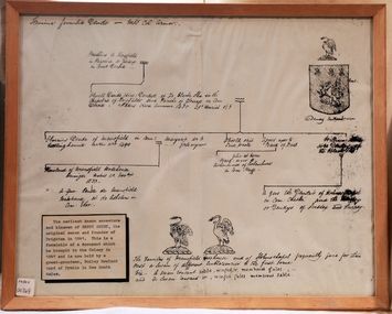
Document - Genealogy Chart Henry Dendy (Photocopy), 19 thC
... Together, Dendy and Were decided on an area 5 miles south from Melbourne, bounded by North Road, East Boundary Road, South Road and to the west by Port Phillip Bay. Were and Dendy pitched their tents in the area now known as ' Park St, Brighton' and sank a well near the corner of 'St Andrew's St and Wells St'. ...Together, Dendy and Were decided on an area 5 miles south from Melbourne, bounded by North Road, East Boundary Road, South Road and to the west by Port Phillip Bay. Were and Dendy pitched their tents in the area now known as ' Park St, Brighton' and sank a well near the corner of 'St Andrew's St and Wells St'. ...In 1840 Henry Dendy, a farmer in Surrey, England acquired a "Special Survey" from the Commissioners for Land and Emigration which gave Dendy the right to choose land in Port Phillip for the "bargain basement" price of only £1 per acre for 5120 acres, (an area of 8 square miles). The Special Survey also included the right to "the shipment of a worker for every £20 spent on land, whose free passage was paid by the Crown, equalling a total of 100 workers ". Accordingly Dendy sold his English holdings and paid the required £5120 and arrived in Melbourne in February 1841. However by this time land in the new colony was selling for £5 - £40 per acre. Because Henry Dendy possessed the order from the Colonial Office in London he was able to successfully oppose Super-intendant LaTrobe's attempts to alter the price of the land. Dendy appointed Jonathan Were, (an entrepreneur, who had arrived in 1839), as his Manager and who later became a partner. Together, Dendy and Were decided on an area 5 miles south from Melbourne, bounded by North Road, East Boundary Road, South Road and to the west by Port Phillip Bay. Were and Dendy pitched their tents in the area now known as ' Park St, Brighton' and sank a well near the corner of 'St Andrew's St and Wells St'. By 1845 J.B Were and Company had bought almost half of Dendy's land and Were built himself "Moorabbin House" in Were St Brighton made from stone, quarried from local cliffs. It was still standing in 1924. Legend records Moorabbin is named after the Aboriginal word for ' Mother's Milk ' The soil is very fertile and well supplied with water especially in the area called 'East Brighton' - now known as Bentleigh and East Bentleigh - By 1850 the area had developed with numerous market gardens, dairy farms, fruit gardens and vineyards supplying food for the growing population of Melbourne.In 1840 Henry Dendy, a farmer in Surrey, England acquired a "Special Survey" from the Commissioners for Land and Emigration which gave Dendy the right to choose land in Port Phillip for the price of only £1 per acre for 5120 acres. This land was called Brighton in the Parish of Moorabbin, County of Bourke and emigrants developed the land establishing market gardens , dairy and poultry farms that provided the food for the growing population of Melbourne. A photocopy of the Genealogy Chart of the Dendy Family that Henry Dendy brought with him when he emigrated to Melbourne 1841Genealogy signs and descriptionsdendy henry, dendy's special survey brighton 1841, governor gipps, captain lonsdale, super-intendant latrobe, port phillip, melbourne, new south wales, squatters, emmigrants, county of bourke, parish of moorabbin, early settlers, pioneers, market gardeners, dairy farmers, fruit farms, moorabbin, bentleigh, brighton, cheltenham, were jonathan binn, -
City of Moorabbin Historical Society (Operating the Box Cottage Museum)
Document, Henry Dendy family Shield
... Together, Dendy and Were decided on an area 5 miles south from Melbourne, bounded by North Road, East Boundary Road, South Road and to the west by Port Phillip Bay. Were and Dendy pitched their tents in the area now known as ' Park St, Brighton' and sank a well near the corner of 'St Andrew's St and Wells St'. ...Together, Dendy and Were decided on an area 5 miles south from Melbourne, bounded by North Road, East Boundary Road, South Road and to the west by Port Phillip Bay. Were and Dendy pitched their tents in the area now known as ' Park St, Brighton' and sank a well near the corner of 'St Andrew's St and Wells St'. ...In 1840 Henry Dendy, a farmer in Surrey, England acquired a "Special Survey" from the Commissioners for Land and Emigration which gave Dendy the right to choose land in Port Phillip for the "bargain basement" price of only £1 per acre for 5120 acres, (an area of 8 square miles). The Special Survey also included the right to "the shipment of a worker for every £20 spent on land, whose free passage was paid by the Crown, equalling a total of 100 workers ". Accordingly Dendy sold his English holdings and paid the required £5120 and arrived in Melbourne in February 1841. However by this time land in the new colony was selling for £5 - £40 per acre. Because Henry Dendy possessed the order from the Colonial Office in London he was able to successfully oppose Super-intendant LaTrobe's attempts to alter the price of the land. Dendy appointed Jonathan Were, (an entrepreneur, who had arrived in 1839), as his Manager and who later became a partner. Together, Dendy and Were decided on an area 5 miles south from Melbourne, bounded by North Road, East Boundary Road, South Road and to the west by Port Phillip Bay. Were and Dendy pitched their tents in the area now known as ' Park St, Brighton' and sank a well near the corner of 'St Andrew's St and Wells St'. By 1845 J.B Were and Company had bought almost half of Dendy's land and Were built himself "Moorabbin House" in Were St Brighton made from stone, quarried from local cliffs. It was still standing in 1924. Legend records Moorabbin is named after the Aboriginal word for ' Mother's Milk ' The soil is very fertile and well supplied with water especially in the area called 'East Brighton' - now known as Bentleigh and East Bentleigh - By 1850 the area had developed with numerous market gardens, dairy farms, fruit gardens and vineyards supplying food for the growing population of Melbourne. dendy henry, dendy's special survey brighton 1841, governor gipps, captain lonsdale, super-intendant latrobe, port phillip, melbourne, new south wales, squatters, emmigrants, county of bourke, parish of moorabbin, early settlers, pioneers, market gardeners, dairy farmers, fruit farms, moorabbin, bentleigh, brighton, cheltenham, were jonathan binn, -
 City of Moorabbin Historical Society (Operating the Box Cottage Museum)
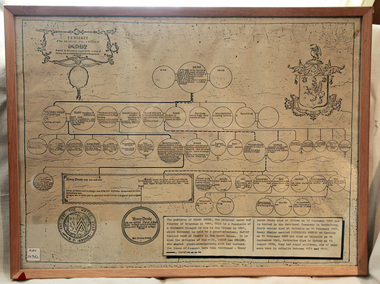
Document - Pedigree of Henry Dendy, c1840 Original ; Copy 1985
... Together, Dendy and Were decided on an area 5 miles south from Melbourne, bounded by North Road, East Boundary Road, South Road and to the west by Port Phillip Bay. Were and Dendy pitched their tents in the area now known as ' Park St, Brighton' and sank a well near the corner of 'St Andrew's St and Wells St'. ...Together, Dendy and Were decided on an area 5 miles south from Melbourne, bounded by North Road, East Boundary Road, South Road and to the west by Port Phillip Bay. Were and Dendy pitched their tents in the area now known as ' Park St, Brighton' and sank a well near the corner of 'St Andrew's St and Wells St'. ...This is a copy of the document brought by Henry Dendy to the Colony in 1841. In 1840 Henry Dendy, a farmer in Surrey, England acquired a "Special Survey" from the Commissioners for Land and Emigration which gave Dendy the right to choose land in Port Phillip for the "bargain basement" price of only £1 per acre for 5120 acres, (an area of 8 square miles). The Special Survey also included the right to "the shipment of a worker for every £20 spent on land, whose free passage was paid by the Crown, equalling a total of 100 workers ". Accordingly Dendy sold his English holdings and paid the required £5120 and arrived in Melbourne in February 1841. However by this time land in the new colony was selling for £5 - £40 per acre. Because Henry Dendy possessed the order from the Colonial Office in London he was able to successfully oppose Super-intendant LaTrobe's attempts to alter the price of the land. Dendy appointed Jonathan Were, (an entrepreneur, who had arrived in 1839), as his Manager and who later became a partner. Together, Dendy and Were decided on an area 5 miles south from Melbourne, bounded by North Road, East Boundary Road, South Road and to the west by Port Phillip Bay. Were and Dendy pitched their tents in the area now known as ' Park St, Brighton' and sank a well near the corner of 'St Andrew's St and Wells St'. By 1845 J.B Were and Company had bought almost half of Dendy's land and Were built himself "Moorabbin House" in Were St Brighton made from stone, quarried from local cliffs. It was still standing in 1924. Legend records Moorabbin is named after the Aboriginal word for ' Mother's Milk ' The soil is very fertile and well supplied with water especially in the area called 'East Brighton' - now known as Bentleigh and East Bentleigh - By 1850 the area had developed with numerous market gardens, dairy farms, fruit gardens and vineyards supplying food for the growing population of Melbourne. A copy of a paper chart of the Pedigree of Henry Dendy in a wooden frame with glassPedigree / of the branch of the family / DENDY moorabbin, brighton, henry dend special survey 1841 y, early settlers, pioneers, market gardeners -
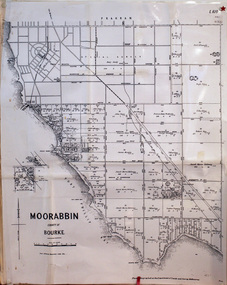 City of Moorabbin Historical Society (Operating the Box Cottage Museum)
Document, laminated photocopy of 'Plan of Moorabbin 1850', 1853
... Dendy asked merchant J.B.Were to manage his affairs and they went ahead with plans to subdivide the surveyed land called 'The Brighton Estate' This area of land extended easterly from the Port Phillip Bay to East Boundary Road and from North Road to South Road in the Parish of Bourke Victoria. ...Dendy asked merchant J.B.Were to manage his affairs and they went ahead with plans to subdivide the surveyed land called 'The Brighton Estate' This area of land extended easterly from the Port Phillip Bay to East Boundary Road and from North Road to South Road in the Parish of Bourke Victoria. ...Weston Bate, 'A history of Brighton' 1962 informs us that in 1840 Henry Dendy, who was a farmer in Sussex England, paid 5,120 pounds sterling @ 1pound per acre for a 'Special Survey of Land in Port Phillip , Australia. Henry arrived in Australia in 1841 on the frigate 'York' with his wife, son, and three servants. He also took advantage of the Government Assistance of Free Immigrants for Survey Purchasers, to help on his estate and persuaded some Sussex men with their families to follow him. However when Dendy arrived in Port Phillip he found that LaTrobe and Gipps were trying to raise the price of land close to Town to 15pounds per acre. Dendy asked merchant J.B.Were to manage his affairs and they went ahead with plans to subdivide the surveyed land called 'The Brighton Estate' This area of land extended easterly from the Port Phillip Bay to East Boundary Road and from North Road to South Road in the Parish of Bourke Victoria. The Privy Council, England , decide that Henry Dendy could purchase the land at 1pound per acre. Land Sales proceeded from 1844 as more immigrants established market gardens, farms and varied businesses in 'Moorabbin'This is a photocopy of a Map of the Moorabbin , County of Bourke c1850 showing the 'Henry Dendy Special Survey 1841'A photocopy of a Map of the Moorabbin , County of Bourke c1850. A3 size laminatedLeft corner : MOORABBIN / COUNTY OF / BOURKEdendy henry, dendy special survey 1841, brighton, moorabbin, ormond, bentleigh, market gardeners, pioneers early settlers, box william, box elizabeth -
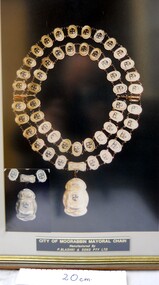 City of Moorabbin Historical Society (Operating the Box Cottage Museum)
Photograph - Photograph , City of Moorabbin Mayoral Chain, circa 1990
... East Brighton, McKinnon, Ormond until the Amalgamation of Councils in 1994. The City of Kingston then took over the area south of South Road while City of Glen Eira took the area to the north Kingston City Council possesses the original Mayoral Chain of former City of Moorabbin and it is displayed on the Moorabbin Mayoral Robe at KCC Office Cheltenham for the Annual Opening meeting of KCC in February . 2018 The Moorabbin Mayoral Robe was sent on 7 year loan to KCC for display at Cheltenham with the former City of Chelsea and former City of Mordialloc Mayoral Robes....City of Moorabbin Historical Society (Operating the Box Cottage Museum) Joyce Park Jasper Road Ormond melbourne City of Moorabbin was proclaimed 1934 and managed the areas of Cheltenham, Highett, Moorabbin, Bentleigh, East Bentleigh, East Brighton, McKinnon, Ormond until the Amalgamation of Councils in 1994. The City of Kingston then took over the area south of South Road while City of Glen Eira took the area to the north ...City of Moorabbin was proclaimed 1934 and managed the areas of Cheltenham, Highett, Moorabbin, Bentleigh, East Bentleigh, East Brighton, McKinnon, Ormond until the Amalgamation of Councils in 1994. The City of Kingston then took over the area south of South Road while City of Glen Eira took the area to the north Kingston City Council possesses the original Mayoral Chain of former City of Moorabbin and it is displayed on the Moorabbin Mayoral Robe at KCC Office Cheltenham for the Annual Opening meeting of KCC in February . 2018 The Moorabbin Mayoral Robe was sent on 7 year loan to KCC for display at Cheltenham with the former City of Chelsea and former City of Mordialloc Mayoral Robes.Since the 1960s far-sighted community members have generously donated many significant items to the ‘Box Cottage’ museum, specifically to provide future generations with a fascinating, and tangible insight into day-to-day life from the 1800’s and up to the mid 1900's. Moorabbin City Council supported their efforts until the Amalgamation of Councils 1994. The City of Kingston donated the 1990 City of Moorabbin Mayoral Robes in 2007 Photograph of the City of Moorabbin Mayoral Chain circa 1990 in a glass covered, wooden frame Photograph of Mayoral Chain worn by Kingston City Council Mayor Steve Staikos, with Councillor Brownlees, in November 2018 when Robe and Jabot were loaned to KCC by CMHS Box Cottage MuseumPlate at base of photograph frame states ' City of Moorabbin Mayoral Chain /Manufactured By / P. Blashki & Sons Pty.Ltd'/moorabbin, kingston, mayors, glen eira, mayoral chain, moorabbin shire -
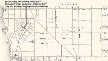 City of Moorabbin Historical Society (Operating the Box Cottage Museum)
Photograph - Map of Dendy's Special Survey, 1852 Map of Henry Dendy's Special Survey of 1841, 19th Century
... Together, Dendy and Were decided on an area 5 miles south from Melbourne, bounded by North Road, East Boundary Road, South Road and to the west by Port Phillip Bay. Were and Dendy pitched their tents in the area now known as ' Park St, Brighton' and sank a well near the corner of 'St Andrew's St and Wells St'. ...Together, Dendy and Were decided on an area 5 miles south from Melbourne, bounded by North Road, East Boundary Road, South Road and to the west by Port Phillip Bay. Were and Dendy pitched their tents in the area now known as ' Park St, Brighton' and sank a well near the corner of 'St Andrew's St and Wells St'. ...A Map drawn in 1852 that shows the 5,120 acres that formed Dendy's Special Survey of 1841. In 1840 Henry Dendy, a farmer in Surrey, England acquired a "Special Survey" from the Commissioners for Land and Emigration which gave Dendy the right to choose land in Port Phillip for the "bargain basement" price of only £1 per acre for 5120 acres, (an area of 8 square miles). The Special Survey also included the right to "the shipment of a worker for every £20 spent on land, whose free passage was paid by the Crown, equalling a total of 100 workers ". Accordingly Dendy sold his English holdings and paid the required £5120 and arrived in Melbourne in February 1841. However by this time land in the new colony was selling for £5 - £40 per acre. Because Henry Dendy possessed the order from the Colonial Office in London he was able to successfully oppose Governor LaTrobe's attempts to alter the price of the land. Dendy appointed Jonathan Were, (an entrepreneur, who had arrived in 1839), as his Manager and who later became a partner. Together, Dendy and Were decided on an area 5 miles south from Melbourne, bounded by North Road, East Boundary Road, South Road and to the west by Port Phillip Bay. Were and Dendy pitched their tents in the area now known as ' Park St, Brighton' and sank a well near the corner of 'St Andrew's St and Wells St'. By 1845 J.B Were and Company had bought almost half of Dendy's land and Were built himself "Moorabbin House" in Were St Brighton made from stone, quarried from local cliffs. It was still standing in 1924. Legend records Moorabbin is named after the Aboriginal word for ' Mother's Milk ' The soil is very fertile and well supplied with water especially in the area called 'East Brighton' - now known as Bentleigh and East Bentleigh - By 1850 the area had developed with numerous market gardens, dairy farms, fruit gardens and vineyards supplying food for the growing population of Melbourne.This Map shows the birth of the Brighton and Moorabbin area. On 18th January1859 Brighton was proclaimed a Municipality and a Borough by October 1863. Meanwhile, following a Petition, the area of East and South Brighton, incorporating Mordialloc, Cheltenham, Mentone, Sandringham and Oakleigh separated from Brighton to form the Moorabbin District Roads Board becoming the first Local Government Authority. Col. William Mair was elected as the first Chairman of the Moorabbin Roads Board. Moorabbin Shire 1871 developed further and was declared a City in1934. The City of Moorabbin was the largest Municipality in Melbourne before the Amalgamation of Councils in 1994 when it was divided in the south to City of Kingston and in the north to City of Glen Eira A Photo-lithographed 1852 Map showing the 5,120 acres that formed Dendy's Special Survey of 1841. Henry Dendy & Jonathan Were chose an area 5 miles south from Melbourne, bounded by North Road, East Boundary Road, South Road and to the west by Port Phillip Bay. Moorabbin County of Bourke / Photo-Lithographed at the department of Lands and Survey. /Melbourne. / Price 1/- brighton, moorabbin, bentleigh, cheltenham, dendy henry, bent thomas, were jonathan, special survey -
 City of Moorabbin Historical Society (Operating the Box Cottage Museum)
Clothing - Clothing, City of Moorabbin Tie, Circa 1960s
... Henry Dendy's Special Survey in 1841 of 5,120 acres in the Parish of Moorabbin , extended from Port Phillip Bay , then East to Boundary Road, South to South Road and North to North Road and became known as Brighton. 1859 Brighton became a Borough with its boundary Thomas Street ,and Bluff Road. ...Henry Dendy's Special Survey in 1841 of 5,120 acres in the Parish of Moorabbin , extended from Port Phillip Bay , then East to Boundary Road, South to South Road and North to North Road and became known as Brighton. 1859 Brighton became a Borough with its boundary Thomas Street ,and Bluff Road. ...The City of Moorabbin existed from 1934 until 1994. Henry Dendy's Special Survey in 1841 of 5,120 acres in the Parish of Moorabbin , extended from Port Phillip Bay , then East to Boundary Road, South to South Road and North to North Road and became known as Brighton. 1859 Brighton became a Borough with its boundary Thomas Street ,and Bluff Road. In 1862 The Moorabbin Roads Board was formed and the extended area now included Cheltenham, Hampton, Sandringham, Black Rock, Beaumaris, Mentone and Mordialloc .and Little Brighton became known as Bentleigh. In 1871 the area became known as The Shire of Moorabbin. Gradually the area was separated into The Borough of Sandringham 1917, ( Black Rock, Beaumaris , Sandringham and Hampton ) Borough of Mentone and Mordialloc 1920, ( Parkdale ). In 1934 The City of Moorabbin was established for the area from South East corner of Thomas Street and North Road , East to Warrigal Road, Clayton Road, Kingston Road , Lower Dandenong Road, then South along Nepean Highway to Balcombe Road and along Bluff Road, Cummins Road, Nepean Highway, Thomas Street to North Road In the 1994 Amalgamation of Councils the City of Moorabbin was divided between the new City of Kingston in the South ( from South Road) and the new City of Glen Eira to the North . It was the largest Municipality in Victoria with a population of 118,865 in 1974This tie c 1960 is a memento of the City of Moorabbin 1934 - 1994Maroon colour, polyester, man's tie with the crest of City of Moorabbin woven on front.around circle enclosing Coat of Arms ; CITY OF MOORABBIN city of moorabbin, moorabbin roads board, moorabbin, brighton, dendy's special survey 1841, early settlers, pioneers, market gardners, dendy henry, were jonathan b, cheltenham, bentleigh, mentone, sandringham, mair william, bent thomas -
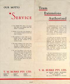 Ballarat Tramway Museum
Pamphlet - Real Estate, T M Burke Pty Ltd, "Tram Extensions Authorised", 1936
... Routes shown as authorised (16-7-1936) are: Keilor Road Essendon, High St North Balwyn and Hawthorn Road East Brighton. ...Routes shown as authorised (16-7-1936) are: Keilor Road Essendon, High St North Balwyn and Hawthorn Road East Brighton. Demonstrates a Real Estate Sales pamphlet. ...Wal Jack collected tramway and railway items for his collection. This pamphlet gives details of the Melbourne Public Transport system - rail, tram and bus in late 1936. Issued by T M Burke Pty Ltd of 840 Collins St Melbourne, Real Estate agents, shows the extensive sub-divisions where land was available for purchase and notes the MMTB authorisation of new tram routes. Gives details of the T M Burke services. Routes shown as authorised (16-7-1936) are: Keilor Road Essendon, High St North Balwyn and Hawthorn Road East Brighton. Demonstrates a Real Estate Sales pamphlet.Pamphlet - four colours printed on cream coloured bond paper, folded vertically originally.letter, wal jack, buninyong, railway lines -
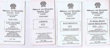 Ballarat Tramway Museum
Ephemera - Timetable/s, Melbourne and Metropolitan Tramways Board (MMTB), Set of 24 MMTB Melbourne tram timetables, 1969
... .) - via Collins St. .8 - Routes 10, 11 - West Preston and routes 9 & 9A Northcote .9 - Routes 15 & 22 - Moreland and 1 & 21 - East Coburg .10 - Route - 15 & 16 - St Kilda Beach and 1 & 2A - South Melbourne Beach - via Swanston St. .11 - Route 19 - North Coburg - City # .12 - Route 42 - Mont Albert - City # .13 - Routes 48 - North Balwyn and Burwood - City .14 - as above, but for Saturdays and Sundays on pink paper .15 - Routes 55 & 56, West Coburg - City - (William St.) - Domain Road. .16 - Route 57 - West Maribyrnong - City .17 - Route 59 - Essendon (Aerodrome) - City .18 - Route 64 & 65 - East Brighton - City .19 - Route 69 - Kew Cotham Road - St. ....) - via Collins St. .8 - Routes 10, 11 - West Preston and routes 9 & 9A Northcote .9 - Routes 15 & 22 - Moreland and 1 & 21 - East Coburg .10 - Route - 15 & 16 - St Kilda Beach and 1 & 2A - South Melbourne Beach - via Swanston St. .11 - Route 19 - North Coburg - City # .12 - Route 42 - Mont Albert - City # .13 - Routes 48 - North Balwyn and Burwood - City .14 - as above, but for Saturdays and Sundays on pink paper .15 - Routes 55 & 56, West Coburg - City - (William St.) - Domain Road. .16 - Route 57 - West Maribyrnong - City .17 - Route 59 - Essendon (Aerodrome) - City .18 - Route 64 & 65 - East Brighton - City .19 - Route 69 - Kew Cotham Road - St. ...Set of 24 MMTB timetables for various routes, dated July 1969. Generally includes Sat and Suns, Good Friday and Christmas day as well as weekdays, unless noted otherwise. Also includes a map of the route, detailed time points, sections, connecting services, fares, and organisation address - 616 Little Collins St. Melbourne. Have been folded into ten portions. All on white paper unless noted otherwise. Items shown with an # - have a sticker modifying timetable information details on the front page. 1154.1 - Route 4 - Carnegie - City .2 - Route 4D - East Malvern (Darling Road) - City # .3 - Route 5 - Malvern Burk Road, - City # .4 - Route 6 - Glen Iris - City # .5 - Route 7 - Camberwell - City # .6 - Route 8 - Toorak - City # .7 - Routes 9, 10 and 12 - South Melbourne and St Kilda Beach - City (Brunswick St.) - via Collins St. .8 - Routes 10, 11 - West Preston and routes 9 & 9A Northcote .9 - Routes 15 & 22 - Moreland and 1 & 21 - East Coburg .10 - Route - 15 & 16 - St Kilda Beach and 1 & 2A - South Melbourne Beach - via Swanston St. .11 - Route 19 - North Coburg - City # .12 - Route 42 - Mont Albert - City # .13 - Routes 48 - North Balwyn and Burwood - City .14 - as above, but for Saturdays and Sundays on pink paper .15 - Routes 55 & 56, West Coburg - City - (William St.) - Domain Road. .16 - Route 57 - West Maribyrnong - City .17 - Route 59 - Essendon (Aerodrome) - City .18 - Route 64 & 65 - East Brighton - City .19 - Route 69 - Kew Cotham Road - St. Kilda Beach # .20 - Route 70 - Wattle Park - City # .21 - Routes 77 - Prahran - City, 78 - North Richmond - Prahran, 79 - North Richmond - St Kilda Beach .22 - Route 82 - Footscray to Moonee Ponds .23 - Route 88 - East Preston - City and Route 96, East Brunswick - City .24 - as above but for Saturdays and Sundays on pink paper. Images of a sample of documents added 16-11-2013.mmtb, timetables, melbourne -
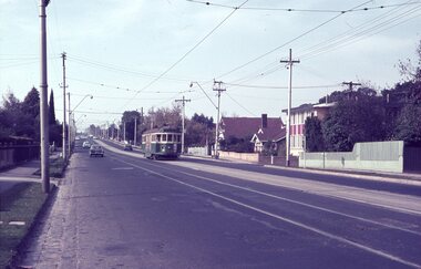 Melbourne Tram Museum
Album - Robert Thomson Slide Collection, "Melbourne 1965 April Box 1"
... Number Brief Description RT107 Whitehorse Road - tram 378 - "City" - route 42 RT108 Malvern Depot - tram 947 - "Malv Tn Hall" - route 6B RT109 tram 7 RT110 tram 7 RT111 North Fitzroy - tram 980 - East Brunswick - Blyth St - route 96 RT112 North Fitzroy - tram 980 - East Brunswick - Blyth St - route 96 RT113 Hawthorn Depot - tram 17 RT114 Location ? tram 471 - "City" - route 7 RT115 Deepdene - tram 848 - "City" - route 42 RT116 Wattle Pk Ter - tram 368 - "City" - route 70 RT117 East Brighton...Number Brief Description RT107 Whitehorse Road - tram 378 - "City" - route 42 RT108 Malvern Depot - tram 947 - "Malv Tn Hall" - route 6B RT109 tram 7 RT110 tram 7 RT111 North Fitzroy - tram 980 - East Brunswick - Blyth St - route 96 RT112 North Fitzroy - tram 980 - East Brunswick - Blyth St - route 96 RT113 Hawthorn Depot - tram 17 RT114 Location ? tram 471 - "City" - route 7 RT115 Deepdene - tram 848 - "City" - route 42 RT116 Wattle Pk Ter - tram 368 - "City" - route 70 RT117 East Brighton ...Photo - see pdf file for further information. Number Brief Description RT107 Whitehorse Road - tram 378 - "City" - route 42 RT108 Malvern Depot - tram 947 - "Malv Tn Hall" - route 6B RT109 tram 7 RT110 tram 7 RT111 North Fitzroy - tram 980 - East Brunswick - Blyth St - route 96 RT112 North Fitzroy - tram 980 - East Brunswick - Blyth St - route 96 RT113 Hawthorn Depot - tram 17 RT114 Location ? tram 471 - "City" - route 7 RT115 Deepdene - tram 848 - "City" - route 42 RT116 Wattle Pk Ter - tram 368 - "City" - route 70 RT117 East Brighton Ter - tram 105 - "East Brighton via Caulfield" - route 64 RT118 Simpson St Siding - tram 889 - "Spencer St" - route 48 & tram 249 -"Football" RT119 Swan St Relay - tram 517 - "Wattle Park Elgar Rd" - route 70 RT120 tram 401 - "City" - route 70 - Swan St RT121 tram 401 - "Wattle Park Elgar Rd" - route 70 - Swan St RT122 tram 330 - "City" - route 70 - Swan St Demonstrates the work of Robert Thomson in photography, collection and/or production of slidesAssembled album in a black presentation folder of 16 colour slides, collected or produced by Robert Thomson. All photographs have been scanned and placed on the Museum's G drive. A list of all photographs with details has been compiled. melbourne, tramways, trams -
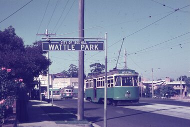 Melbourne Tram Museum
Album - Robert Thomson Slide Collection, AETA Convention 1971
... Number Brief Description RT123 1971 Convention - 9.4.71 - tram 610 - "Special" - Wattle park terminus RT124 Mt Alexander Road - 980 - "Special" RT125 St Kilda Jct - 7.4.71 - "St Kilda Beach" - route 16 RT126 North Balwyn Terminus - 9.4.71 - tram 840 - "Nth Balwyn" route 79 RT127 Preston - tram 980 - "City - Spencer St" - route 9A RT128 St Kilda Jct - "E Brighton Malv Burke Rd" - route 64 RT129 St Kilda Park St Terminus 12.4.71 - tram 394 - "Special" & tram 1017 - "West Preston - Northcote" - route 10 RT130 Carnegie 9.4.71 - tram 106 - "St Kilda Jun" - route 17 RT131 High St - tram 980 - "East Preston" - route 98 RT132 St Kilda Park St Terminus 12.4.71 - tram 894 - "West Preston" - route 10 RT133 St Kilda Park St Terminus 12.4.71 - tram 894 - "West Preston" - route 10 RT134 Wattle Park - 9.4.71 - tram 610 - "City" - route 70 RT135 Wellington Parade - 9.4.71 - tram 840 - "City - Flinders & Spencer St Cnr" - route 23 RT136 Melville Rd West Coburg 12.4.71 - tram 787 - route 55 ...Number Brief Description RT123 1971 Convention - 9.4.71 - tram 610 - "Special" - Wattle park terminus RT124 Mt Alexander Road - 980 - "Special" RT125 St Kilda Jct - 7.4.71 - "St Kilda Beach" - route 16 RT126 North Balwyn Terminus - 9.4.71 - tram 840 - "Nth Balwyn" route 79 RT127 Preston - tram 980 - "City - Spencer St" - route 9A RT128 St Kilda Jct - "E Brighton Malv Burke Rd" - route 64 RT129 St Kilda Park St Terminus 12.4.71 - tram 394 - "Special" & tram 1017 - "West Preston - Northcote" - route 10 RT130 Carnegie 9.4.71 - tram 106 - "St Kilda Jun" - route 17 RT131 High St - tram 980 - "East Preston" - route 98 RT132 St Kilda Park St Terminus 12.4.71 - tram 894 - "West Preston" - route 10 RT133 St Kilda Park St Terminus 12.4.71 - tram 894 - "West Preston" - route 10 RT134 Wattle Park - 9.4.71 - tram 610 - "City" - route 70 RT135 Wellington Parade - 9.4.71 - tram 840 - "City - Flinders & Spencer St Cnr" - route 23 RT136 Melville Rd West Coburg 12.4.71 - tram 787 - route 55 Demonstrates the work of Robert Thomson in photography, collection and/or production of slides Melbourne tramways trams Assembled album in a black presentation folder of 14 colour slides, collected or produced by Robert Thomson. ...Photo - see pdf file for further information. Number Brief Description RT123 1971 Convention - 9.4.71 - tram 610 - "Special" - Wattle park terminus RT124 Mt Alexander Road - 980 - "Special" RT125 St Kilda Jct - 7.4.71 - "St Kilda Beach" - route 16 RT126 North Balwyn Terminus - 9.4.71 - tram 840 - "Nth Balwyn" route 79 RT127 Preston - tram 980 - "City - Spencer St" - route 9A RT128 St Kilda Jct - "E Brighton Malv Burke Rd" - route 64 RT129 St Kilda Park St Terminus 12.4.71 - tram 394 - "Special" & tram 1017 - "West Preston - Northcote" - route 10 RT130 Carnegie 9.4.71 - tram 106 - "St Kilda Jun" - route 17 RT131 High St - tram 980 - "East Preston" - route 98 RT132 St Kilda Park St Terminus 12.4.71 - tram 894 - "West Preston" - route 10 RT133 St Kilda Park St Terminus 12.4.71 - tram 894 - "West Preston" - route 10 RT134 Wattle Park - 9.4.71 - tram 610 - "City" - route 70 RT135 Wellington Parade - 9.4.71 - tram 840 - "City - Flinders & Spencer St Cnr" - route 23 RT136 Melville Rd West Coburg 12.4.71 - tram 787 - route 55 Demonstrates the work of Robert Thomson in photography, collection and/or production of slidesAssembled album in a black presentation folder of 14 colour slides, collected or produced by Robert Thomson. All photographs have been scanned and placed on the Museum's G drive. A list of all photographs with details has been compiled. melbourne, tramways, trams -
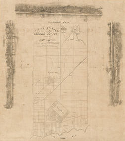 Bayside Gallery - Bayside City Council Art & Heritage Collection
Map, H.B. Foot, Plan of the Brighton Estate containing 5120 acres, first special survey at Port Phillip, c. 1842
... Brighton Estate, also known as Dendy's Special Survey. In 1840 Henry Dendy, a farmer in Surrey, England acquired a "Special Survey" from the Commissioners for Land and Emigration which gave him the right to choose land in Port Phillip for the low price of £1 per acre for 5120 acres. Dendy appointed Jonathan Binns Were, as his agent, who later became a partner. Together, Dendy and Were decided on an area 5 miles south from Melbourne, bounded by North Road, East...Brighton Estate. The main section of the plan shows Port Phillip Bay at the bottom, and is bounded by North Road, South Road and East Boundary Road. ...Brighton Estate. The main section of the plan shows Port Phillip Bay at the bottom, and is bounded by North Road, South Road and East Boundary Road. ...This plan records the Brighton Estate, also known as Dendy's Special Survey. In 1840 Henry Dendy, a farmer in Surrey, England acquired a "Special Survey" from the Commissioners for Land and Emigration which gave him the right to choose land in Port Phillip for the low price of £1 per acre for 5120 acres. Dendy appointed Jonathan Binns Were, as his agent, who later became a partner. Together, Dendy and Were decided on an area 5 miles south from Melbourne, bounded by North Road, East Boundary Road, South Road and to the west by Port Phillip Bay. Their Brighton Estate was first surveyed by T. S. Townsend in May 1841 and was re-surveyed by Robert Hoddle. Dendy and Were were making plans to sell the land and advertised a 30-guinea prize for the best subdivision which was to be divided into a village, marine residences, suburban and cultivation allotments, with the remainder being divided into country sections. The competition was won by H.B. Foot, who planned the village around a reserve and crescents and a 'green belt' forming the town boundary. brighton estate, dendy's special survey, special survey, henry dendy, jonathan binns were, w.b. were, survey, plan, map, brighton, george ward cole, baker's lithographer, hibernian, subdivision, town planning, cartographic material, h.b. foot -
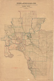 Kew Historical Society Inc
Plan, Melbourne & Metropolitan Board of Works : Contour Plan of Melbourne & Suburbs : Melbourne Sewage, 1894
... east, and from Preston in the north, south to Sandringham. Suburbs are outlined in coloured ink. Red lines indicate main and branch sewers in existence at the beginning of 1894 in central and inner Melbourne. These extended as far as Williamstown and Brighton, but not yet as far as Kew, where sewering did not commence until 1901. Contour lines show the topography, which was important for indicating the fall of the land for the laying of sewers and drainage channels. Kew appears to be fairly undeveloped at this date except for railway lines and stations (the Kew and Outer Circle lines), main roads...east, and from Preston in the north, south to Sandringham. Suburbs are outlined in coloured ink. Red lines indicate main and branch sewers in existence at the beginning of 1894 in central and inner Melbourne. These extended as far as Williamstown and Brighton, but not yet as far as Kew, where sewering did not commence until 1901. Contour lines show the topography, which was important for indicating the fall of the land for the laying of sewers and drainage channels. Kew appears to be fairly undeveloped at this date except for railway lines and stations (the Kew and Outer Circle lines), main roads ...The Melbourne and Metropolitan Board of Works (MMBW) plans were produced from the 1890s to the 1950s. They were crucial to the design and development of Melbourne's sewerage and drainage system. This plan forms part of a large group of MMBW plans and maps that was donated to the Society by the Mr Poulter, City Engineer of the City of Kew in 1989. Within this collection, thirty-five hand-coloured plans, backed with linen, are of statewide significance as they include annotations that provide details of construction materials used in buildings in the first decade of the 20th century as well as additional information about land ownership and usage. The copies in the Public Record Office Victoria and the State Library of Victoria are monochrome versions which do not denote building materials so that the maps in this collection are invaluable and unique tools for researchers and heritage consultants. A number of the plans are not held in the collection of the State Library of Victoria so they have the additional attribute of rarity.Digital copy of an original MMBW plan. This contour plan shows the area identified by the MMBW for purposes of drainage and sewerage in 1894. The suburbs represented extend from Williamstown in the west to Bulleen in the east, and from Preston in the north, south to Sandringham. Suburbs are outlined in coloured ink. Red lines indicate main and branch sewers in existence at the beginning of 1894 in central and inner Melbourne. These extended as far as Williamstown and Brighton, but not yet as far as Kew, where sewering did not commence until 1901. Contour lines show the topography, which was important for indicating the fall of the land for the laying of sewers and drainage channels. Kew appears to be fairly undeveloped at this date except for railway lines and stations (the Kew and Outer Circle lines), main roads, the Kew Lunatic Asylum Reserve and Studley Park. However, the contour plan does not accurately represent the density of settlement, nor the large number of houses, which were being built in Kew and other suburbs from the 1850s to the land boom of the late 1880’s and early 1890’s. This plan is part of a large and historically significant group of MMBW plans and maps that was donated to the Society by the Mr Poulter, City Engineer of the City of Kew in 1989.mmbw contour plan of melbourne and suburbs, melbourne and metropolitan board of works, melbourne sewage, cartography