Showing 384 items matching " railways routes"
-
 Glen Eira Historical Society
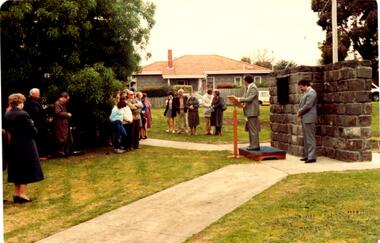
Letter - Rosstown Railway
... ... Railways Routes...Marara Road Gardens Marara Road Marara Gardens Narrawong Road Ceremonies Caulfield Mayors Polglase Norma Mayoral Secretaries Railways Routes Documents Correspondence Rudski Brian Calder Graham Events and Activities Official Buildings Insignia Local Government Local Officials and Employees Parks and Reserves Buildings Structures and Establishments Official Events Festivals and Celebrations Occupations Political Processes Local History History Financial Economics Local Government Finance Letter Rosstown Railway ...This file contains two items: 1/A group of eight letters, predominantly between Hon. Secretary of Caulfield Historical Society R. Ballantyne and members of the Caulfield City Council written between 1981 and 1983, regarding the installation of a plaque in commemoration of the centenary of the Rosstown Railway. The first two letters are handwritten from R. Ballantyne to G. Calder and Carol Camy, dated 01/06/1981 and 22/02/1982. The letter to G. Calder supports a suggestion in the May edition of the CAULFIELD CONTACT for the installation of a plaque in celebration of the centenary of the Rosstown Railway, suggesting a potential site for another plaque on Curraweena Road. The letter to Carol Harry discusses the costing of the plague and a possible contribution towards this cost from the Caulfield Historical Society. The letter appears to be incomplete, having no sign off from the author. Attached to the letter is what appears to be a suggestion for the inscription of the plaque. The letters addressed to R. Ballantyne are typed and dated 12/06/1981, 24/06/1981, 14/07/19891, 17/12/1981 and 08/09/1983, from A. Craig and D.B. Hogan on behalf of City Manager G.K. Calder and City Liason Officer Carol Harry. All letters concern the commemorative plaque, with these from Carol Harry including handwritten notes which appear to be in R. Ballantyne’s handwriting. The final letter is from Mayoral Secretary Norma Polglase to Miss B. Snowball, dated 23/08/1983, inviting her to attend the unveiling of the plaque. Also included in the item are Council Committee Meeting minutes, dated 16/05/1981, broaching the subject of installing the plaque in Koornang Road. 2/Four colour photographs and two black and white copies of one of the photographs, all dated 18/09/1983 and showing the opening of the commemorative plaque in Marrara Gardens. Two photographs picture Mayor Brian Rudski and City Manager Graham Calder with a crowd of unidentified people present. One photograph and both copies are of the inscription on the plaque, with the wording identical to that of the handwritten note by R. Ballantyne, in item one.caulfield, caulfield south, calder g.k., calder g., hawthorn road, glen eira road, ballantyne r., office workers, caulfield contact, norman peter, groups, glen huntly, koornang road, mills, sugar mills, caulfield historical society, caulfield city council, caulfield town hall, official buildings, glen huntly neville street fourteen, parliamentary representatives, rosstown, rosstown railway, rosstown railway centenary, festivals and celebrations, centenaries, historical markers, plaques, monuments and memorials, ross murray, railways, land transport, curraweena road, parts of buildings or structures, bluestone structures, construction materials, caulfield community liaison officer, harry carol, currency, finances, onley peter, elsternwick, oakleigh, council meetings, caulfield council chambers, caulfield municipal chambers, caulfield municipal offices, craig a., caulfield city manager, city of caulfield, caulfield physical environment committee, public meetings, meetings, ross james, hogan o.b., arrow engraving, campbell f., snowball miss., elsternwick gladstone parade nineteen, walters w.r., marara road gardens, marara road, marara gardens, narrawong road, ceremonies, caulfield mayors, polglase norma, mayoral secretaries, railways routes, documents, correspondence, rudski brian, calder graham, events and activities, official buildings, insignia, local government, local officials and employees, parks and reserves, buildings structures and establishments, official events, festivals and celebrations, occupations, political processes, local history, history, financial economics, local government finance -
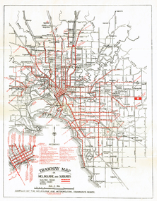
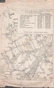
 Melbourne Tram Museum
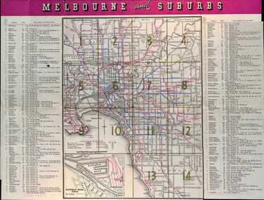
Map, Victorian Railways (VR), "Melbourne and Suburbs", 1956
... routes...railways...Map printed by the Victorian Railways in 1955 gives places of interest, some facts about Melbourne, and amusements, with the map showing rail, tram, and railway bus routes, suburbs, golf links, sporting grounds, and municipalities. ... printed map of Melbourne maps melbourne tramways bus routes railways Map - 8 fold printed in colour "Melbourne and Suburbs" Map Victorian Railways (VR) ...Map printed by the Victorian Railways in 1955 gives places of interest, some facts about Melbourne, and amusements, with the map showing rail, tram, and railway bus routes, suburbs, golf links, sporting grounds, and municipalities. The Bourke St tram route to East Preston is shown but not the Nicholson St East Brunswick line which opened during mid 1956. Provides a detailed list of suburbs, miles from the GPO, and how reached from where. Notes it was published in Jan. 1956 by the VR Public Relations and Betterment Board.Demonstrates a Victorian Railways printed map of MelbourneMap - 8 fold printed in colourmaps, melbourne, tramways, bus routes, railways -
 Surrey Hills Historical Society Collection
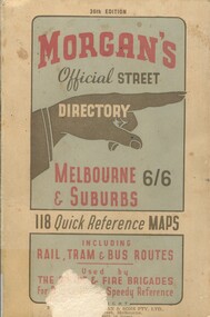
Book, Morgan's Official Street Directory, c1940s
... It also shows bus routes, railways and tramways routes on the maps....It also shows bus routes, railways and tramways routes on the maps....It also shows bus routes, railways and tramways routes on the maps. ...incl.index. This Street Directory of Melbourne and suburbs, c1940s, includes a list of suburbs, their mileage from the city and how to reach them; an index to localities as well as the index to streets appearing on the maps. It also shows bus routes, railways and tramways routes on the maps.incl.index. This Street Directory of Melbourne and suburbs, c1940s, includes a list of suburbs, their mileage from the city and how to reach them; an index to localities as well as the index to streets appearing on the maps. It also shows bus routes, railways and tramways routes on the maps.melbourne metropolitian area, suburbs, cities and towns, maps -
 Federation University Historical Collection
Book, Jacobs Lewis Vines Architects and Conservation Planners, Historic Sites Survey: Ballarat Study Area, 1980, 1980
... railways...explorers routes...Barker Library (top floor) Mount Helen goldfields This survey was commissioned by the Land Conservation Council, Australian Heritage Commission and the Ministry for Conservation historic sites ballarat Wendy jacobs miles lewis gary vines berringa buninyong creswick dunnstown fiery creek lal lal langi logan cathcart mount cole Mount Egerton nerrina gong gong wombat state forest railways explorers routes early roads land conservation council ausralian hertiage commission department of planning ICOMOS (Burra) Charter nigel lewis richard aitken freehold land public land langi ghiran New jubille mine birthday tunnel mine pitfield plains smythesdale buninyong company Mount Clear mt clear canadian gully Warrenheip Distillery thomas mitchell waterloo trawalla beaufort raglan internment camps forestry mining mining mt egerton Mary Hollick Collection Jubilee Mine Burra Charter Historica areas data form explorers Egerton Company Black Horse mine Mt Egerton Government Battery kaolin Mines Anderson Brothers Barkstead Anderson's Tramway Clarkesdale Berry Leads Birthday Tunnel Mine Berringa Warrenheip Australasian Company Mount Mercer Lanvi-Kal-Kal water race 114 page report on historic sites in the Ballarat region. ...This survey was commissioned by the Land Conservation Council, Australian Heritage Commission and the Ministry for Conservation 114 page report on historic sites in the Ballarat region. It includes information on sites, a schexdule of sites, silte selection and designated areas (ie around towns)historic sites, ballarat, wendy jacobs, miles lewis, gary vines, berringa, buninyong, creswick, dunnstown, fiery creek, lal lal, langi logan, cathcart, mount cole, mount egerton, nerrina, gong gong, wombat state forest, railways, explorers routes, early roads, land conservation council, ausralian hertiage commission, department of planning, icomos (burra) charter, nigel lewis, richard aitken, freehold land, public land, langi ghiran, new jubille mine, birthday tunnel mine, pitfield plains, smythesdale, buninyong company, mount clear, mt clear, canadian gully, warrenheip distillery, thomas mitchell, waterloo, trawalla, beaufort, raglan, internment camps, forestry, mining, mining, mt egerton, mary hollick collection, jubilee mine, burra charter, historica areas data form, explorers, egerton company, black horse mine, mt egerton government battery, kaolin mines, anderson brothers, barkstead, anderson's tramway, clarkesdale, berry leads, birthday tunnel mine berringa, warrenheip, australasian company, mount mercer, lanvi-kal-kal, water race -
 Sunshine and District Historical Society Incorporated
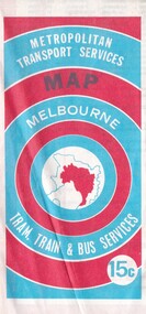
Map - Joseph 'Joe' Wlodarczyk Collection - Metropolitan Transport Services Map, No Date
... Railways...Bus Routes...Albans Railway Station. Railways Bus Routes Tramlines Metropolitan Transport Services Map Melbourne Tram, train & Bus Services 15c Fold out paper map Map Joseph 'Joe' Wlodarczyk Collection - Metropolitan Transport Services Map ...This combined public transport map provides information on services operated by the Melbourne and Metropolitan Tramways Board, private bus operators and Victorian Railways, Bus Proprietors' Association and the Transport Regulations Board. It was published in the interest of travelers in the Melbourne metropolitan area.This map shows Melbourne's transport network prior to the City Loop being built. Locally the map shows the St. Albans electrification line stopping at the St. Albans Railway Station.Metropolitan Transport Services Map Melbourne Tram, train & Bus Services 15crailways, bus routes, tramlines -
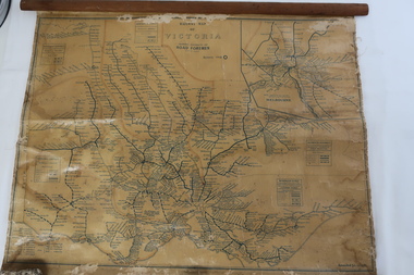 Kiewa Valley Historical Society
Map - Railway Map of Victoria, Amended to 1/11/1945
... Plastic on parchment with detailed railway routes (in green) across Victoria including each district's 'Road Foremen' and 'Depots'. ...Victorian railways 1945 trains transport Plastic on parchment with detailed railway routes (in green) across Victoria including each district's 'Road Foremen' and 'Depots'. ...Railways began in the 1850s and were privately owned and operated. Later they were taken over by the Victorian Government reaching a peak in the early 1940s.Steam trains were followed by electric trains with both running after the war in 1945.Bright was the closest station to the Kiewa Valley but road transport was used more often as the Kiewa Valley Highway was improved with the construction of the Kiewa Hydro Electric Scheme. To travel to Melbourne or Sydney by train residents went via Wodonga/Albury where they also did their shopping.Plastic on parchment with detailed railway routes (in green) across Victoria including each district's 'Road Foremen' and 'Depots'. There is a length of flat wood attached by 10 tacks across the top of the mapvictorian railways 1945, trains, transport -
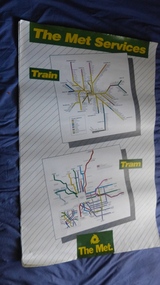 Melbourne Tram Museum
Poster, The Met, "The Met Services", mid 1990's
... Routes... Railways...Melbourne Tram Museum 8 Wallen Road Hawthorn melbourne Trams tramways Melbourne Tramways Tram Routes Railways Map Posters Tickets Neighbourhood tickets Poster - full colour on semi gloss paper titled "The Met Services" showing in a diagrammatic form the Melbourne tram and rail routes. ...Poster - full colour on semi gloss paper titled "The Met Services" showing in a diagrammatic form the Melbourne tram and rail routes. For the tram section, (similar to Reg Item 509), shows major street names, route numbers, principal suburbs, terminal names, central area (pre Docklands, post light rail to St Kilda and Port Melbourne) and ticket zones. The rail map section shows the Neighbourhood ticket zones, the rail line via Altona (the direct route is not shown) and shows the St Kilda and Port Melbourne light rail lines. Has The Met logo and the Public Transport Corporation names on the bottom. Mid 1990's, Batman Ave still shown. See also Reg Items 696 and 696 for maps of the time.trams, tramways, melbourne, tramways, tram routes, railways, map, posters, tickets, neighbourhood tickets -
 Greensborough Historical Society
Map, Dianne Edwards, Part of Parish of Yan Yean 1878, 1978
... Map includes Crown Portions V - XVII, showing Yan Yean Reservoir, Melbourne-Whittlesea Railway route, names of landowners, roads and various other features west of Greensborough Road. ...Greensborough Historical Society 34A Glenauburn Road Lower Plenty Lower Plenty melbourne Map includes Crown Portions V - XVII, showing Yan Yean Reservoir, Melbourne-Whittlesea Railway route, names of landowners, roads and various other features west of Greensborough Road. ...Map includes Crown Portions V - XVII, showing Yan Yean Reservoir, Melbourne-Whittlesea Railway route, names of landowners, roads and various other features west of Greensborough Road. Redrawn by A. R. Blair in 1978.1 p. black and white photocopy of mapyan yean reservoir, yan yean -
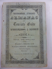 Warrnambool and District Historical Society Inc.
Book, Warrnambool Standard Almanac 1891, 1891
... The booklet contains a fold-out sheet with a map of Victorian railway routes and many sketches and illustrations. ...The booklet contains a fold-out sheet with a map of Victorian railway routes and many sketches and illustrations. ...This booklet was given to subscribers to the Warrnambool Standard newspaper as an almanac for the year 1891. These Standard Almanacs were produced from 1875 to 1930. They contain much local information on Warrnambool and district about the businesses, government officials, harbour management, churches, banks, schools, societies and organizations etc. The Warrnambool Standard was established in 1872 and continues to this day. This booklet is of high significance as it contains much information about Warrnambool and district for the year 1891. It is an important resource tool for those studying and writing the history of Warrnambool and district. The name ‘Barber’ is on the front cover of this booklet and this appears to refer to George Barber, the son of George Barber, a well-known solicitor who opened a legal practice in Warrnambool in 1855. He died in 1879 and it appears a member or members of his family went to live in the Maryborough district as this booklet came into the collection of the Warrnambool and District Historical Society via the Midlands Historical Society. This is a soft cover booklet of 135 pages, plus pages at the back containing a gardener’s almanac and advertisements. The cover is pale green with black lettering and a decorative black and white border. The cover is a little frayed at the edges and the spine cover is partly torn away. The booklet contains a fold-out sheet with a map of Victorian railway routes and many sketches and illustrations. The name on the front cover is handwritten in pencil. ‘Barber’warrnambool standard newspaper, history of warrnambool, standard almanac 1891 -
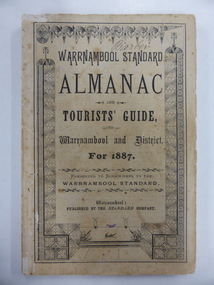 Warrnambool and District Historical Society Inc.
Book, Warrnambool Standard Almanac 1887, 1887
... There is a fold-out page with a map of the railway routes in Victoria. The cover is buff-coloured with black lettering and is slightly frayed. ...There is a fold-out page with a map of the railway routes in Victoria. The cover is buff-coloured with black lettering and is slightly frayed. ...This booklet was given to subscribers to the Warrnambool Standard newspaper as an almanac for the year 1887. These Standard almanacs were produced from 1875 to 1930. They contain much local information on Warrnambool and district about the businesses, government officials, schools, societies and organizations, harbour management, churches, banks etc. The Warrnambool Standard newspaper was established in 1872 and continues to this day. This booklet is of high significance as it contains much valuable information on Warrnambool and district for the year 1887. It is a very important research tool for those studying and writing the history of Warrnambool and district. This copy has the name ‘Barber’ on the front cover and probably refers to George Barber, the son of George Barber, a well-known solicitor who opened a legal practice in Warrnambool in 1855. He died in 1879 and it appears that a member or members of his family went to live in the Maryborough district. This copy came into the collection of the Warrnambool and District Historical Society via the Midlands Historical Society.This is a soft cover booklet of 73 pages, plus several pages of advertisements. The section on the tourist’s guide to Warrnambool is printed in pink. There is a fold-out page with a map of the railway routes in Victoria. The cover is buff-coloured with black lettering and is slightly frayed. There is some scribble on the first page and the back cover. There are many black and white illustrations and several sketches of Warrnambool and district printed in pink. The name ‘Barber’ is handwritten in black ink on the front cover. ‘Barber’ ‘Miss Duff c/o Mrs Hyslop Farquar Lodge Lysle Street Ladysmith South Africa’warrnambool standard newspaper, history of warrnambool, standard almanac1887 -
 Whitehorse Historical Society Inc.
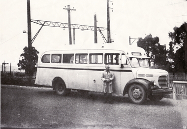
Photograph, Bill Glasson & Bus
... The terminal was on the north side of Mitcham Railway Station. Route was Mitcham to Park Orchards....The terminal was on the north side of Mitcham Railway Station. Route was Mitcham to Park Orchards. glasson bill Bus Black and white photo of Bill Glasson and Local Bus. ...Bill Glasson and Charlie Young owner the bus. The terminal was on the north side of Mitcham Railway Station. Route was Mitcham to Park Orchards.Black and white photo of Bill Glasson and Local Bus. Documents accompanying: ND1837 glasson, bill, bus -
 Melbourne Tram Museum
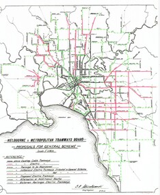
Poster, Association of Railway Enthusiasts (ARE), "General Scheme for Future Tramways", 1998
... Railway Enthusiasts in 1998 extracted from the MMTB Annual Report for 1923. Has comments on the scheme, new lines, proposals and shows the lines proposed. Map shows cable lines, existing electric lines, tramways proposed to be abandoned (Rathdowne St), Domain Road, alternative routes, railways and railway tram routes. ...Map shows cable lines, existing electric lines, tramways proposed to be abandoned (Rathdowne St), Domain Road, alternative routes, railways and railway tram routes. Includes a photo of tram 105. 2nd copy - not lamined - folded into three vertically. ...Laminated A3 poster or sheet titled "General Scheme for Future Tramways", prepared by the Association of Railway Enthusiasts in 1998 extracted from the MMTB Annual Report for 1923. Has comments on the scheme, new lines, proposals and shows the lines proposed. Map shows cable lines, existing electric lines, tramways proposed to be abandoned (Rathdowne St), Domain Road, alternative routes, railways and railway tram routes. Includes a photo of tram 105. 2nd copy - not lamined - folded into three vertically. See also Reg Item 2089 for an original of this document.trams, tramways, mmtb, general scheme, new track, closure, construction, routes, tram 105 -
 Ringwood and District Historical Society
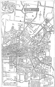
Document, Reference Map of Ringwood, Victoria - Circa 1962-63
... Legend: Railway Lines, Bus Routes, Reserved Open Areas, Town Hall & P.O., Police Station, Area Being Sewered 62-63, Primary Secondary and Technical Schools, and Collector's Districts, e.g. ...Ringwood and District Historical Society 125A Warrandyte Road Ringwood North melbourne Legend: Railway Lines, Bus Routes, Reserved Open Areas, Town Hall & P.O., Police Station, Area Being Sewered 62-63, Primary Secondary and Technical Schools, and Collector's Districts, e.g. ...A3 size photocopied street map with alpha-numeric labeled divisions identifying "Collector's Districts" (of un-named organisation). Legend: Railway Lines, Bus Routes, Reserved Open Areas, Town Hall & P.O., Police Station, Area Being Sewered 62-63, Primary Secondary and Technical Schools, and Collector's Districts, e.g. A1, A2, B1, B2, etc. -
 Melbourne Tram Museum
Map, Melbourne & Metropolitan Tramways Board (MMTB), "Tramway Map of Melbourne and Suburbs", c1939
... Folded map (4 x 2) by Melbourne and Metropolitan Tramways Board, c1939, of Melbourne tramways, showing tram routes (cable, electric and VR), bus routes, railway lines, major points of interest and major streets. ...Melbourne Tram Museum 8 Wallen Road Hawthorn melbourne Trams tramways Map MMTB VR Cable Trams Folded map (4 x 2) by Melbourne and Metropolitan Tramways Board, c1939, of Melbourne tramways, showing tram routes (cable, electric and VR), bus routes, railway lines, major points of interest and major streets. ...Folded map (4 x 2) by Melbourne and Metropolitan Tramways Board, c1939, of Melbourne tramways, showing tram routes (cable, electric and VR), bus routes, railway lines, major points of interest and major streets. No printing or information on the rear. Once part of another document with remnants of glue on the rear top left hand edge. See Reg Item 801 for a 1927c map.trams, tramways, map, mmtb, vr, cable trams -
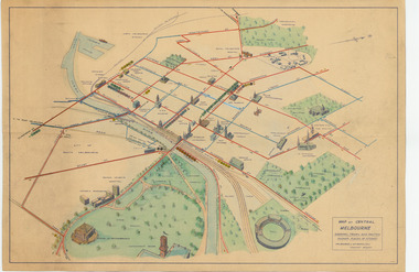 Melbourne Tram Museum
Map, Melbourne & Metropolitan Tramways Board (MMTB), "Map of Central Melbourne", c1952
... Map - dyeline print then hand coloured, titled "Map of Central Melbourne", subtitled "Showing tram and bus routes, railways, places of interest:. Includes railway yards. gardens, trams routes shown in direction in some places. ...Melbourne Tram Museum 8 Wallen Road Hawthorn melbourne Trams tramways MMTB Map Melbourne Tram Routes South Melbourne Depot Hanna St Depot Latrobe St La Trobe St Map - dyeline print then hand coloured, titled "Map of Central Melbourne", subtitled "Showing tram and bus routes, railways, places of interest:. Includes railway yards. gardens, trams routes shown in direction in some places. ...Map - dyeline print then hand coloured, titled "Map of Central Melbourne", subtitled "Showing tram and bus routes, railways, places of interest:. Includes railway yards. gardens, trams routes shown in direction in some places. Has initials WKGP in bottom right hand corner. Map c1952, after the Latrobe St lines opened but before Bourke St lines opened. Note: 1 - The Hanna St or South Melbourne depot is shown south of City Road, not south of Sturt Street as it should have been. 2 - route 78 shown terminating at Batman Ave is incorrect, ran from Victoria and Church Sts. Original document scanned as a high res tiff file, approx. 60MB, see large files directory - htd3736-large.tiftrams, tramways, mmtb, map, melbourne, tram routes, south melbourne depot, hanna st depot, latrobe st, la trobe st -
 Melbourne Tram Museum
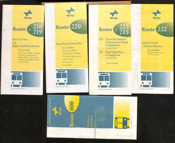
Ephemera - Timetable - Met Bus - set of 5, The Met, 1996/97
... Set of 5 Met Bus timetables - all with a route map on the rear. 1 - Routes 216 and 219, Deer Park West - City - Brighton Beach/Gardenvale - dated 27/10/1996 2 - route 220 - Sunshine - Gardenvale - dated 14/4/1996 3 - Routes 223 and 215 - Yarraville Station to Highpoint and Deer Park West to Highpoint - dated Dec. 1996 4 - Route 232 - Altona North - Victoria Market via West Gate Freeway and Crown Casino - dated 14/4/1996 - this service effectively combined the two railway tram routes. 5 - Route 600 - St Kilda to Southland via Elwood, Brighton, Sandringham, Black Rock and Cheltenham - dated March 1997...Melbourne Tram Museum 8 Wallen Road Hawthorn melbourne Set of 5 Met Bus timetables - all with a route map on the rear. 1 - Routes 216 and 219, Deer Park West - City - Brighton Beach/Gardenvale - dated 27/10/1996 2 - route 220 - Sunshine - Gardenvale - dated 14/4/1996 3 - Routes 223 and 215 - Yarraville Station to Highpoint and Deer Park West to Highpoint - dated Dec. 1996 4 - Route 232 - Altona North - Victoria Market via West Gate Freeway and Crown Casino - dated 14/4/1996 - this service effectively combined the two railway tram routes. 5 - Route 600 - St Kilda to Southland via Elwood, Brighton, Sandringham, Black Rock and Cheltenham - dated March 1997 Yields information about some of the Met Bus services in 1996 and 1997. maps bus services route 216 route 219 route 220 route 223 route 215 route 232 route 600 Met Bus Set of five Met Bus timetables, DL size, printed in two colours. ...Set of 5 Met Bus timetables - all with a route map on the rear. 1 - Routes 216 and 219, Deer Park West - City - Brighton Beach/Gardenvale - dated 27/10/1996 2 - route 220 - Sunshine - Gardenvale - dated 14/4/1996 3 - Routes 223 and 215 - Yarraville Station to Highpoint and Deer Park West to Highpoint - dated Dec. 1996 4 - Route 232 - Altona North - Victoria Market via West Gate Freeway and Crown Casino - dated 14/4/1996 - this service effectively combined the two railway tram routes. 5 - Route 600 - St Kilda to Southland via Elwood, Brighton, Sandringham, Black Rock and Cheltenham - dated March 1997Yields information about some of the Met Bus services in 1996 and 1997.Set of five Met Bus timetables, DL size, printed in two colours.maps, bus services, route 216, route 219, route 220, route 223, route 215, route 232, route 600, met bus -
 Melbourne Tram Museum
Map, P. Sohns, "Strassenbahn Melbourne Gleisplan", 10-9-1992
... Shows the track layout, crossovers, depots, route numbers, railway/tramway level crossings, terminus details, road names and a CBD insert. ...Shows the track layout, crossovers, depots, route numbers, railway/tramway level crossings, terminus details, road names and a CBD insert. ...Map of Melbourne's tramway system prepared for a German audience - as at 28-5-1992. Shows the track layout, crossovers, depots, route numbers, railway/tramway level crossings, terminus details, road names and a CBD insert. Prepared by P Sohns of Germany - dated 10-9-1992.Yields information Melbourne tramways and routes in 1992.Map - A2 sheet folded to A4.tramways, maps, melbourne, germany -
 Melbourne Tram Museum
Document - Report, Parliamentary Public Works Committee, "Parliamentary Public Works Committee Report Plenty Road, Preston, Tramway Extension Enquiry, 1967
... Map shows extension proposed, bus routes, railway lines, streets - folded into 4....Map shows extension proposed, bus routes, railway lines, streets - folded into 4. ...Report contained within a light brown card folder, containing a photocopy of report titled "Parliamentary Public Works Committee Report (including map) on The Plenty Road, Preston, Tramway Extension Enquiry - 1967". Report stapled in top right hand corner, 15 pages examining the extension of the East Preston route to Bolderwood Parade. Map shows extension proposed, bus routes, railway lines, streets - folded into 4.AETA stamp on front and inside sheet and "4E6" in ink on front cover. AETA stamp on the bottom right hand corner of the map.trams, tramways, east preston, new tramway, bolderwood parade, proposals -
 Melbourne Tram Museum
Document - Report, Melbourne & Metropolitan Tramways Board (MMTB), "Passenger movements by public transport for the Central city Business area based on results of the 1964 Melbourne Metropolitan Transportation Study, Nov. 1965
... Report - Foolscap landscape format, red tape binding - approx. 80 pages with notes, diagrams, charts, maps showing passenger traffic for parts of each route, including Railway Stations, passenger flows, titled "Passenger movements by public transport for the Central city Business area based on results of the 1964 Melbourne Metropolitan Transportation Study....Melbourne Tram Museum 8 Wallen Road Hawthorn melbourne Trams tramways MMTB Tramways Melbourne Surveys Passengers Railways Maps In top right hand corner "Lees" in ink Report - Foolscap landscape format, red tape binding - approx. 80 pages with notes, diagrams, charts, maps showing passenger traffic for parts of each route, including Railway Stations, passenger flows, titled "Passenger movements by public transport for the Central city Business area based on results of the 1964 Melbourne Metropolitan Transportation Study. ...Report - Foolscap landscape format, red tape binding - approx. 80 pages with notes, diagrams, charts, maps showing passenger traffic for parts of each route, including Railway Stations, passenger flows, titled "Passenger movements by public transport for the Central city Business area based on results of the 1964 Melbourne Metropolitan Transportation Study.In top right hand corner "Lees" in inktrams, tramways, mmtb, tramways, melbourne, surveys, passengers, railways, maps -
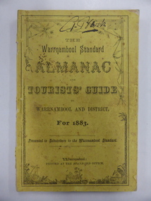 Warrnambool and District Historical Society Inc.
Book, Warrnambool Standard Almanac 1883, 1883
... There is a fold-out page of the Western District’s railway and coach routes and the pages on the tourist’s guide to Warrnambool are printed in green. ...There is a fold-out page of the Western District’s railway and coach routes and the pages on the tourist’s guide to Warrnambool are printed in green. ...This booklet was given to subscribers to the Warrambool Standard newspaper as an almanac for the year 1883. These Standard almanacs were produced from 1875 to 1930. They contain much local information on Warrnambool and district about the businesses, government officials, schools, societies and organizations, harbour management, churches, banks etc. The Warrnambool Standard newspaper was established in 1872 and continues to this day. This booklet is of high significance as it contains much valuable information on Warrnambool and district for the year 1883. It is a very valuable research tool for those studying and writing the history of Warrnambool and district. The copy is signed ‘G. Barber’ and probably this refers to the son of George Barber, a well-known solicitor who opened a legal practice in Warrnambool in 1855. He died in 1879 and it appears that a member or members of his family went to live in the Maryborough area as this copy came into the collection of the Warrnambool and District Historical Society via the Midlands Historical Society.This is a soft cover booklet of 72 pages plus several pages of a gardener’s calendar and 20 pages of advertisements. The cover is yellow with black lettering and the spine is partly torn away. There is a fold-out page of the Western District’s railway and coach routes and the pages on the tourist’s guide to Warrnambool are printed in green. The booklet contains several black and white illustrations. There are several pages that are torn with parts of the pages missing. The front cover has the name of ‘G. Barber’ handwritten in black ink. ‘G. Barber’ warrnambool standard newspaper, history of warrnambool, standard almanac 1883, g barber solicitor -
 Dandenong/Cranbourne RSL Sub Branch
Document - Framed Information Sheet, About The Map, Circa 2000s
... The information sheet belongs with a map showing the Burma Thailand Railway and it's route with the various camps and P.O.W centres. ...Dandenong/Cranbourne RSL Sub Branch 44 – 50 Clow Street Dandenong melbourne The information sheet belongs with a map showing the Burma Thailand Railway and it's route with the various camps and P.O.W centres. ...The information sheet belongs with a map showing the Burma Thailand Railway and it's route with the various camps and P.O.W centres. The map was produced over a period of 15 months and drawn in four stages. Shows Hellfire Pass formerly ( The Konyu Cutting). The 50 Kilo Camp in Burma. There were 56 stations and 87 camps on the route of the map. The map gives due credibility and was released as a limited edition of 1000 copies only. Copies of the map are displayed all over the world including Staffordshire in England, University of Houston, National Guard Museum of Texas and on display at the Australian and New Zealand Embassies in Bangkok.Framed information sheet of the map produced to show the various camps and sights along the Burma Thailand railway. The map was produced using a number of older railway maps, including the Escritt translated map and a local Thai road touring map. -
 Bendigo Historical Society Inc.
Document - MINING REPORTS - MAP OF PART OF THE BENDIGO GOLDFIELD INCLUDING WHITE HILLS AND EAGLEHAWK
... Map shows reef lines, gullies, railway line, tram route, type of rock, name of mine, Calls and Dividends. ...Map shows reef lines, gullies, railway line, tram route, type of rock, name of mine, Calls and Dividends. ...BHS CollectionMap of part of the Bendigo Goldfield including White Hills and Eaglehawk. Map shows reef lines, gullies, railway line, tram route, type of rock, name of mine, Calls and Dividends. Also Deepest Mine Victoria Quartz 4614 ft. Names of Mines are Garden Gully United, Great Ext'd Hustlers, Johnson's Reef, South New Moon, New Moon, Catherine Reef, Virginia, Central Red White & Blue, Ironbark, Kock's Pioneer, Carlisle and the Hercules & Energetic. Map is part of the Albert Richardson Collection of mining documents and research. document, gold, mining reports, mining reports, map of part of the bendigo goldfield including white hills and eaglehawk, pabst bendigo goldfield, garden gully united, great ext'd hustlers, johnson's reef, south new moon, new moon, catherine reef, virginia, central red white & blue, ironbark, kock's pioneer, carlisle, hercules & energetic. victoria quartz -
 Melbourne Tram Museum
Document - Research Notes, H. S. McComb, "Tramways in the Borough of Northcote", 1940's
... Original and five carbon copies of the three pages extracted from the Victorian Government Gazette - 14/9/1888 authorising the construction of a tramway in the City of Northcote, giving details of routes, railway crossing of the proposed Clifton Hill and Royal Park lines, depot, motive power, speed, time, passengers only, safety, tolls and charges and governance. ...Melbourne Tram Museum 8 Wallen Road Hawthorn melbourne Trams tramways Northcote Cable Trams Electric Traction Horse Trams Railways Original and five carbon copies of the three pages extracted from the Victorian Government Gazette - 14/9/1888 authorising the construction of a tramway in the City of Northcote, giving details of routes, railway crossing of the proposed Clifton Hill and Royal Park lines, depot, motive power, speed, time, passengers only, safety, tolls and charges and governance. ...Original and five carbon copies of the three pages extracted from the Victorian Government Gazette - 14/9/1888 authorising the construction of a tramway in the City of Northcote, giving details of routes, railway crossing of the proposed Clifton Hill and Royal Park lines, depot, motive power, speed, time, passengers only, safety, tolls and charges and governance. Each of the three page sets have been clipped together using a paper clip. Items 2053 to 2057 within box 72.3 in a brown folder marked "Northcote CC" in red pencil.trams, tramways, northcote, cable trams, electric traction, horse trams, railways -
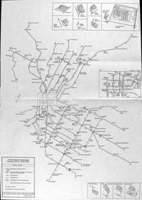
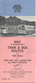 Ballarat Tramway Museum
Map, Survey and Mapping for MMTB, "Map of Melbourne's Trams and Bus routes and all night services", Jan. 1967
... Fold out sheet coloured map, 12 portions or folds, - title - "Map of Melbourne's Trams and Bus routes and all night services" map shows trams lines, route numbers, terminal points, bus routes, railway lines, blow up of city area with places of interest and key. ...Fold out sheet coloured map, 12 portions or folds, - title - "Map of Melbourne's Trams and Bus routes and all night services" map shows trams lines, route numbers, terminal points, bus routes, railway lines, blow up of city area with places of interest and key. ...Fold out sheet coloured map, 12 portions or folds, - title - "Map of Melbourne's Trams and Bus routes and all night services" map shows trams lines, route numbers, terminal points, bus routes, railway lines, blow up of city area with places of interest and key. On rear details, places of interest, suburb index, index to routes, first and last services, Sunday am services, all night bus services and locations of depots and head office. 2nd copy added 11-8-2006. Images of document - scanned to A3 size and overlapping added 30/10/13 On rear "out of date" stamp and 1 "cancelled" stamp - red ink.trams, tramways, melbourne, map, tram & bus services, all night services -
 Melbourne Tram Museum
slide - Colour - Melbourne Trams, David Verrier, August 1989
... Has Bank of Melbourne adverts. 4 - Elizabeth St terminus from Flinders Lane, looking south. 5 - Z3 156 (route 19), arriving Elizabeth St terminus at Flinders St 6 - Z3 176 crossing Park St, Parkville, West Coburg, route 68. 7 - Z3 217 near zoo, about to pass under the railway over bridge - route 68 8 - Z3 129, ditto inbound. ...Has Bank of Melbourne adverts. 4 - Elizabeth St terminus from Flinders Lane, looking south. 5 - Z3 156 (route 19), arriving Elizabeth St terminus at Flinders St 6 - Z3 176 crossing Park St, Parkville, West Coburg, route 68. 7 - Z3 217 near zoo, about to pass under the railway over bridge - route 68 8 - Z3 129, ditto inbound. ...1 - W7 1033, South Melbourne / St Kilda terminus in Park St. showing route 10. Has Bank of Melbourne and Estate Mortgage adverts. 2 - B2 2012 (route 96) , Fitzroy Street, St Kilda 3 - SW6 858 (route 16), Fitzroy St St Kilda. Has Bank of Melbourne adverts. 4 - Elizabeth St terminus from Flinders Lane, looking south. 5 - Z3 156 (route 19), arriving Elizabeth St terminus at Flinders St 6 - Z3 176 crossing Park St, Parkville, West Coburg, route 68. 7 - Z3 217 near zoo, about to pass under the railway over bridge - route 68 8 - Z3 129, ditto inbound. Yields information about Melbourne tram operations in Sept 1999Set of eight white / grey plastic slides, marked "CS System" and date stamped 08/89tramways, z3 class, b2 class, park st, south melbourne beach, route 10, w7 class, tram 1033, tram 2012, fitzroy st, tram 858, route 16, route 96, elizabeth street, flinders st, tram 156, route 19, tram 176, parkville, route 68, tram 217, tram 129 -
 Melbourne Tram Museum
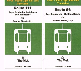
Ephemera - Timetable/s, The Met, "The Met Tram North-South Light Rail Line Timetable", Oct. 1988
... route map, sections and fares and phone contact numbers. Titled "The Met Tram North-South Light Rail Line Timetable" Issued at the time of the opening of the light rail services along the former St Kilda and Port Melbourne railway lines. .1 - Route 96 - East Brunswick - St Kilda Beach via Bourke St city - 24/10/1988 .2 - Route 111 - Royal Exhibition Buildings - Port Melbourne via Bourke St City - 24/10/1988...route map, sections and fares and phone contact numbers. Titled "The Met Tram North-South Light Rail Line Timetable" Issued at the time of the opening of the light rail services along the former St Kilda and Port Melbourne railway lines. .1 - Route 96 - East Brunswick - St Kilda Beach via Bourke St city - 24/10/1988 .2 - Route 111 - Royal Exhibition Buildings - Port Melbourne via Bourke St City - 24/10/1988 "The Met Tram North-South Light Rail Line Timetable" Ephemera Timetable/s The Met ...Set of 2 The Met Tram timetables, folded sheets, 7 or 10 sections, providing timetables for specific routes, day of week giving information on tram times at specific time points, route map, sections and fares and phone contact numbers. Titled "The Met Tram North-South Light Rail Line Timetable" Issued at the time of the opening of the light rail services along the former St Kilda and Port Melbourne railway lines. .1 - Route 96 - East Brunswick - St Kilda Beach via Bourke St city - 24/10/1988 .2 - Route 111 - Royal Exhibition Buildings - Port Melbourne via Bourke St City - 24/10/1988trams, tramways, the met, timetables, melbourne, fares, light rail, route 96, route 111, conversion, port melbourne, st kilda, east brunswick -
 Melbourne Tram Museum
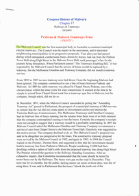
Document - Personal Papers, "Coopers History of Malvern - Chapter 17 Railways &Tramways (1st Part), Prahran & Malvern Tramways Trust", 1990s
... Details the establishment of tramways in Malvern and Prahran, including the City of Malvern, Alex Cameron, issues with the State Government and the Railways, buses, opening, costs, routes, the success of the tramway, working hours, Thomas Bent, Victorian Parliament and transfer to the MMTB....Details the establishment of tramways in Malvern and Prahran, including the City of Malvern, Alex Cameron, issues with the State Government and the Railways, buses, opening, costs, routes, the success of the tramway, working hours, Thomas Bent, Victorian Parliament and transfer to the MMTB. ...Personal Papers, or typed copy of part of Chapter 17, 10 A4 sheets stapled in top left hand corner, titled "Coopers History of Malvern - Chapter 17 Railways &Tramways (1st Part), Prahran & Malvern Tramways Trust". written by J B Cooper in 1935. Details the establishment of tramways in Malvern and Prahran, including the City of Malvern, Alex Cameron, issues with the State Government and the Railways, buses, opening, costs, routes, the success of the tramway, working hours, Thomas Bent, Victorian Parliament and transfer to the MMTB.trams, tramways, pmtt, history, buses, malvern, city of malvern -
 Melbourne Tram Museum
Slide - CBD tram operations - set of 4, Warren Doubleday, 26/12/1979
... Set of four colour slides of tram operations in the CBD area on 26/12/1979 1 - SW5 787 passing under the Flinders St railway viaduct, running a route 55 service. Note that most of the mechanical signalling equipment on the gantry has been removed. 2 - Z3 117 running a route 88 service in Bourke St at Queen St. 3 - Z class 93 to Spencer St at Elizabeth St, with Parliament House in the far background. ...Set of four colour slides of tram operations in the CBD area on 26/12/1979 1 - SW5 787 passing under the Flinders St railway viaduct, running a route 55 service. Note that most of the mechanical signalling equipment on the gantry has been removed. 2 - Z3 117 running a route 88 service in Bourke St at Queen St. 3 - Z class 93 to Spencer St at Elizabeth St, with Parliament House in the far background. ...Set of four colour slides of tram operations in the CBD area on 26/12/1979 1 - SW5 787 passing under the Flinders St railway viaduct, running a route 55 service. Note that most of the mechanical signalling equipment on the gantry has been removed. 2 - Z3 117 running a route 88 service in Bourke St at Queen St. 3 - Z class 93 to Spencer St at Elizabeth St, with Parliament House in the far background. Photo taken at Queen St. 4 - Z3 117 in Bourke St at Queen St running a route 88 East Preston service.Yields information about the operation of trams in the CBD area and the Flinders St viaduct.Kodak cardboard mount slides - set of fourHave photographer's reference number written on the slide.tramways, flinders st, bourke st, tram 787, railways, tram 117, sw5 class, z3 class, tram 93 -
 Ballarat Tramway Museum
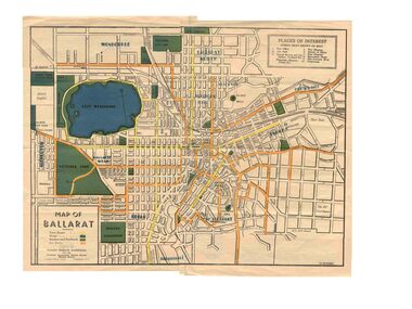
Map, Greater Ballarat Association and George Netherway, "Map of Ballarat", c1945
... Five colour map of Ballarat, showing streets, places of interest, Parks, tram routes, bus routes, railway lines, prepared by G. C. Netherway, Greater Ballarat Association, for the Victorian Government Tourist Bureau, Ballarat Branch, c1945. ...Trams tramways Ballarat Tram Routes Bus Routes Map Lists Five colour map of Ballarat, showing streets, places of interest, Parks, tram routes, bus routes, railway lines, prepared by G. C. Netherway, Greater Ballarat Association, for the Victorian Government Tourist Bureau, Ballarat Branch, c1945. ...Yields information about Greater Ballarat, including trams, buses, locations and streets. Has a strong association with George Netherway.Five colour map of Ballarat, showing streets, places of interest, Parks, tram routes, bus routes, railway lines, prepared by G. C. Netherway, Greater Ballarat Association, for the Victorian Government Tourist Bureau, Ballarat Branch, c1945. Shows suburbs names, location of orphanage, the lack of development north of Howitt St, in Wendouree. Map is part diagrammatic and is not entirely to scale. On rear is a road map of the Ballarat area, lists of statistics, beauty spots, look outs, art and culture, points of historical interest, industrial products and recreation. Note: Image 1, assembled from four scans, does not entirely match at edges. See Reg item 2074 for photographic image of another version map. See Reg Item 5613 for another version of this map. trams, tramways, ballarat, tram routes, bus routes, map, lists -
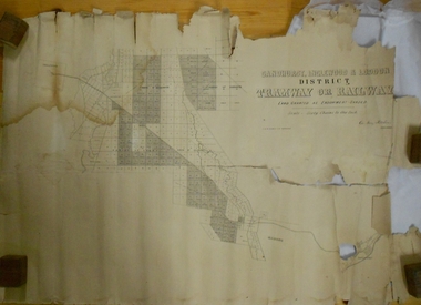 Bendigo Historical Society Inc.
Map - MARKS COLLECTION: TRAMWAY OR RAILWAY MAP SANDHURST
... On bottom RH corner, is small map of Sandhurst, showing railway reserve. Top LH corner, Inglewood. Map shows route of railway line from Sandhurst to Inglewood....On bottom RH corner, is small map of Sandhurst, showing railway reserve. Top LH corner, Inglewood. Map shows route of railway line from Sandhurst to Inglewood. ...Original map of 'land granted as endowment' for tramway or railway. On top Rh corner of map, in bold print 'Sandhurst, Inglewood & Loddon district Tramway or Railway. Land granted as endowment shaded, scale 60 chains to 1 inch. Lithographed by J & W. Holmes, Lith. Sandhurst'. Signed by Geo Avery Fletcher, Engineer. Map shows Parish of Leichardt, Parish of Yarraberb, Parish of Bridgwater and a section of Marong. On bottom RH corner, is small map of Sandhurst, showing railway reserve. Top LH corner, Inglewood. Map shows route of railway line from Sandhurst to Inglewood.map, marks collection, railway, inglewood