Showing 25 items matching "boggy creek"
-
 Lakes Entrance Historical Society
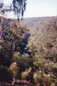
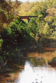
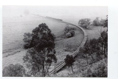
Photograph - Boggy Creek Gorge, 1999
... Boggy Creek Gorge...Boggy Creek Gorge cuts through volcanics just before it meets salty water at Nowa Nowa Arm of Lake Tyers....Colour photograph from a vantage point of the distant Boggy Creek Gorge surrounded by steep tree and scrub covered ranges. ...Nowa Nowa Victoria Photograph Boggy Creek Gorge ...Boggy Creek Gorge cuts through volcanics just before it meets salty water at Nowa Nowa Arm of Lake Tyers.Colour photograph from a vantage point of the distant Boggy Creek Gorge surrounded by steep tree and scrub covered ranges. Nowa Nowa Victoriavegetation, waterways -
 Lakes Entrance Historical Society
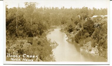
Photograph - Boggy Creek Nowa Nowa Victoria, Caire, Nicholas John, 1905c
... Boggy Creek Nowa Nowa Victoria...Black and white photograph of a Rocky Gorge with two Aboriginal posed on the rocks with water in the creek called Boggy Creek at Nowa Nowa. Victoria...Victoria Photograph Boggy Creek Nowa Nowa Victoria Caire, Nicholas John ...Rocky Scenery at Murmuring Falls. This is the source of Lake Tyers and the course of the water is known as Boggy Creek.The waters rush and roar impetuoulsy over these rocks in winter time.Black and white photograph of a Rocky Gorge with two Aboriginal posed on the rocks with water in the creek called Boggy Creek at Nowa Nowa. Victoriawaterways, topography, aboriginals -
 Lakes Entrance Historical Society
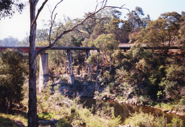
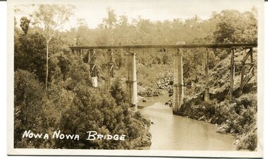
Photograph - Boggy Creek bridge Nowa Nowa, Victoria, 1998
... Boggy Creek bridge Nowa Nowa, Victoria...Colour photograph of the railway bridge over Boggy Creek, showing the bridge high above the waterway, rocky terrain and scrubby vegetation. ...Nowa Nowa, Victoria, Photograph Boggy Creek bridge Nowa Nowa, Victoria ...Re Heritage StudyColour photograph of the railway bridge over Boggy Creek, showing the bridge high above the waterway, rocky terrain and scrubby vegetation. Nowa Nowa, Victoria,bridges, waterways, transport -
 Orbost & District Historical Society
black and white photograph, c1920-1954
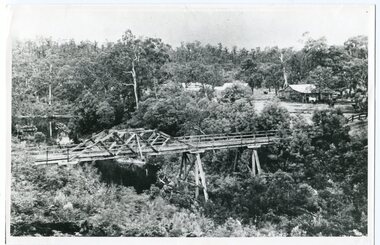
... boggy-creek-bridge East-Gippsland-Railway...This is a copy of "THE BRIDGE AT BOGGY CREEK, NOWA NOWA, LAKE TYERS." which is a Rose Stereograph Co postcard. ...on back - "Boggy Creek bridge - Nowa Nowa 1887 LaTrobe Collection"...Orbost & District Historical Society Ruskin Street Orbost gippsland This is a copy of "THE BRIDGE AT BOGGY CREEK, NOWA NOWA, LAKE TYERS." which is a Rose Stereograph Co postcard. ...This is a copy of "THE BRIDGE AT BOGGY CREEK, NOWA NOWA, LAKE TYERS." which is a Rose Stereograph Co postcard. Boggy Creek Bridge was built in 1916 as part of the Bairnsdale to Orbost extension to the main Gippsland Railway, and is situated in the middle of the township of Nowa Nowa, crossing a steep-sided and well-timbered creek-valley. This section of the line closed in 1987. This bridge plays a major part in the identity and history of the town of Nowa Nowa, This item is associated with the East Gippsland Railway.A large black / white photograph of a large wooden bridge across a creek. There is a house and outbuildings in the background on the right. It is in a bush setting. on back - "Boggy Creek bridge - Nowa Nowa 1887 LaTrobe Collection"boggy-creek-bridge east-gippsland-railway -
 Lakes Entrance Historical Society
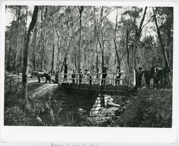
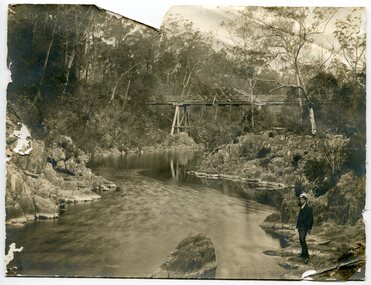
Photograph - Boggy Creek,Nowa Nowa, 1910
... Boggy Creek,Nowa Nowa...Sepia photograph showing old bridge over Boggy Creek, presumably near Nowa Nowa. Two men and boy on bridge. ...Gippsland Victoria Photograph Boggy Creek,Nowa Nowa ...Sepia photograph showing old bridge over Boggy Creek, presumably near Nowa Nowa. Two men and boy on bridge. Bridge supported by rough logs in centre and at ends. Gippsland Victoriabridges, waterways -
 Lakes Entrance Historical Society
Photograph - Boggy Creek Railway bridge Nowa Nowa. 2012
... Boggy Creek Railway bridge Nowa Nowa. 2012...Colour photograph of the railway bridge over Boggy Creek at Nowa Nowa. Bridge is built on combination of solid concrete piers, timber trestle piers on concrete to flood level, and timber piers. ...Nowa Nowa Victoria Photograph Boggy Creek Railway bridge Nowa Nowa. 2012 ...Date made December 2012Colour photograph of the railway bridge over Boggy Creek at Nowa Nowa. Bridge is built on combination of solid concrete piers, timber trestle piers on concrete to flood level, and timber piers. Nowa Nowa Victoriabridges, waterways, transport -
 Orbost & District Historical Society
Photograph - Nowa Nowa photos, Stanley Vogt, c.1920s
... ...Boggy Creek...The Hotel shown in 2716.1 was located near the crossing of Boggy Creek. Boggy Creek Boggy Creek (2716.2) which has a wonderful deep gorge which was and still is a major natural attraction. ...S Vogt 2716.2 Boggy Creek, Nowa Nowa Stanley Vogt, Bairnsdale ...The Hotel shown in 2716.1 was located near the crossing of Boggy Creek. Boggy Creek Boggy Creek (2716.2) which has a wonderful deep gorge which was and still is a major natural attraction. ...Nowa Nowa is at the top of Lake Tyers. The Princes Highway from Orbost to Bairnsdale travels through Nowa Nowa. From the earliest times of white settlement, Nowa Nowa developed as a stopping-off point on the Highway, and also as a tourist and holiday location, in association with the Buchan caves and Lakes Entrance. These photos show aspects of travel and tourism, possibly 1920s. The Hotel shown in 2716.1 was located near the crossing of Boggy Creek. Boggy Creek Boggy Creek (2716.2) which has a wonderful deep gorge which was and still is a major natural attraction. These photos are significant because they show aspects of Nowa Nowa in the c. 1920s.Two b/w photographs/postcards of Nowa Nowa. 2716.1 Two cars and a group of people in front of a building. One vehicle has no roof. This postcard has a piece torn out at the bottom right hand corner. 2716.2 Eight people standing as a group on a rock platform beside a creek. The people are on the r.h.s. of the photo. In the background is a bushland setting and a rocky creek. 2716.1 Nowa Nowa Hotel. S Vogt 2716.2 Boggy Creek, Nowa Nowa Stanley Vogt, Bairnsdale nowa nowa, boggy creek -
 Orbost & District Historical Society
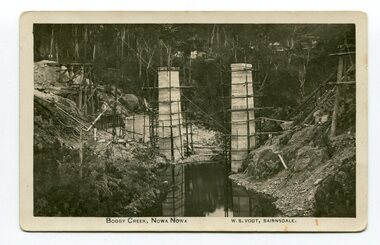
photograph / postcard, early 20th century
... boggy-creek-bridge vogt-w.s. railway-bridges east-gippsland-railway railway-construction train...Boggy Creek Bridge was built in 1916 as part of the Bairnsdale to Orbost extension to the main Gippsland Railway, and is situated in the middle of the township of Nowa Nowa, crossing a steep-sided and well-timbered creek-valley. ...on front of postcard - caption - " Boggy Creek, Nowa Nowa, W.S. Vogt, Bairnsdale"...This bridge plays a major part in the identity and history of the town of Nowa Nowa, since Boggy Creek’s steep sided valley divides the township into two components. boggy-creek-bridge vogt-w.s. railway-bridges east-gippsland-railway railway-construction train on front of postcard - caption - " Boggy Creek, Nowa Nowa, W.S. ...Boggy Creek Bridge was built in 1916 as part of the Bairnsdale to Orbost extension to the main Gippsland Railway, and is situated in the middle of the township of Nowa Nowa, crossing a steep-sided and well-timbered creek-valley. This section of the line closed in 1987.This item is a pictorial record of the construction of the Boggy Creek railway bridge on the East Gippsland line. This bridge plays a major part in the identity and history of the town of Nowa Nowa, since Boggy Creek’s steep sided valley divides the township into two components. A black / white photograph on a postcard showing the construction of a railway bridge across a creek. The end pylons are evident and there is scaffolding on both sides of the creek. Two copies of a black / white photograph showing the construction of a railway bridge across a cree. The end pylons are evident and there is scaffolding on both sides of the creek. There is a steam train on the rail track.on front of postcard - caption - " Boggy Creek, Nowa Nowa, W.S. Vogt, Bairnsdale"boggy-creek-bridge vogt-w.s. railway-bridges east-gippsland-railway railway-construction train -
 Orbost & District Historical Society
black / white photograph, late 19th - early 29th century
... Boggy-Creek-Nowa-Nowa...The building in this photograph of Boggy Creek is probably the first Nowa Nowa Hotel built by Moses Faithfull, in 1890. ...on front - bottom left -"BOGGY CREEK NOWA NOWA"...Orbost & District Historical Society Ruskin Street Orbost gippsland The building in this photograph of Boggy Creek is probably the first Nowa Nowa Hotel built by Moses Faithfull, in 1890. ...The building in this photograph of Boggy Creek is probably the first Nowa Nowa Hotel built by Moses Faithfull, in 1890. Moses Faithful came to Australia from England with his parents on the Royal Consort in 1844. After living at Bulla, Pakenham and Wurruk he and his wife moved to Hospital Creek in about 1885 where he took up the first selection of land at Upper Hospital Creek. As well as farming he built the first hotel at Nowa Nowa in 1890. He had charge of the hotel until 1895 when he sold to Mary Stirling. Moses died on 8th July 1901, aged 66, at the residence of his son-in-law, David Price, at Newmerella, and buried in the Orbost cemetery.This hotel was built in 1890 and doubled as a coaching stop on the inland route. Settlement grew up around the hotel. It was sold 1895 to Mary Stirling who husband own the land the hotel stood on. The hotel burned down on 29 July 1955. This is a pictorial record of Nowa Nowa in the late 19th century.A black / white photograph / postcard of a creek with a building on the rightside. a windmillis to the left. The banks of the creek are well-vegetated.on front - bottom left -"BOGGY CREEK NOWA NOWA"boggy-creek-nowa-nowa -
 Lakes Entrance Historical Society
Photograph - Bridges, 1896
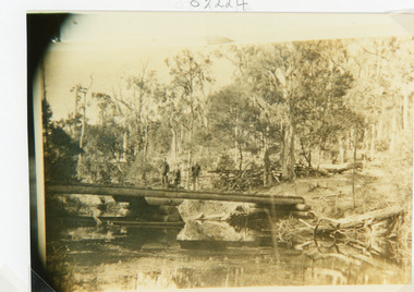
... Black and white photograph showing Boggy Creek Bridge,seven men on bridge, one horse at left end of bridge and two horses at right hand end of bridge. ...Boggy Creek Bridge - Vic (Written on back)...Lakes Entrance Historical Society 4 Marine Parade Lakes Entrance gippsland Original photo 12.5 x 17 cm on grey card 20 x 24.5 cm Bridges Waterways Vegetation Boggy Creek Bridge - Vic (Written on back) Black and white photograph showing Boggy Creek Bridge,seven men on bridge, one horse at left end of bridge and two horses at right hand end of bridge. ...Original photo 12.5 x 17 cm on grey card 20 x 24.5 cmBlack and white photograph showing Boggy Creek Bridge,seven men on bridge, one horse at left end of bridge and two horses at right hand end of bridge. Bridge rests on log supports under. No water in creek. Thick bush around area. East Gippsland VictoriaBoggy Creek Bridge - Vic (Written on back)bridges, waterways, vegetation -
 Orbost & District Historical Society
black and white photograph, first half 20th century
... Boggy-Creek-railway-bridge Nowa-Nowa railway-bridge East-Gippsland-Railway Orbost-Bairnsdale-Railway...This appears to be the Boggy Creek bridge and to have been taken at Nowa Nowa. ...Orbost & District Historical Society Ruskin Street Orbost gippsland This appears to be the Boggy Creek bridge and to have been taken at Nowa Nowa. ...This appears to be the Boggy Creek bridge and to have been taken at Nowa Nowa. The Boggy Creek Bridge was built in 1916 as part of the Bairnsdale to Orbost extension to the main Gippsland Railway, and is situated in the middle of the township of Nowa Nowa, crossing a steep-sided and well-timbered creek-valley. This section of the line closed in 1987.This bridge plays a major part in the identity and history of the town of Nowa Nowa, since Boggy Creek’s steep sided valley divides the township into two components. It is part of the East Gippsland Railway line.A black / white photograph / postcard of a tall railway bridge, with concrete pylons in the centre,There is a creek below.on front - bottom left - " NOWA NOWA BRIDGE"boggy-creek-railway-bridge nowa-nowa railway-bridge east-gippsland-railway orbost-bairnsdale-railway -
 Orbost & District Historical Society
black and white photograph, first half 20th century
... boggy-creek-bridge-nowa-nowa...This appears to be the Boggy Creek bridge and to have been taken at Nowa Nowa. ...Orbost & District Historical Society Ruskin Street Orbost gippsland This appears to be the Boggy Creek bridge and to have been taken at Nowa Nowa. ...This appears to be the Boggy Creek bridge and to have been taken at Nowa Nowa. The Boggy Creek Bridge was built in 1916 as part of the Bairnsdale to Orbost extension to the main Gippsland Railway, and is situated in the middle of the township of Nowa Nowa, crossing a steep-sided and well-timbered creek-valley. This section of the line closed in 1987.This bridge plays a major part in the identity and history of the town of Nowa Nowa, since Boggy Creek’s steep sided valley divides the township into two components. It is part of the East Gippsland Railway line.A black / white photograph of a bridge across a creek. A young man in a suit is standing in the foreground.boggy-creek-bridge-nowa-nowa -
 Orbost & District Historical Society
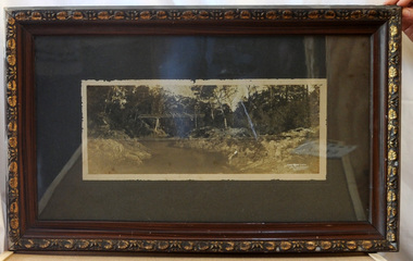
framed black and white photograph, C1920
... Boggy-Creek-Nowa-Nowa East-Gippsland-railway bridge-rail...Boggy Creek Bridge was built in 1916 as part of the Bairnsdale to Orbost extension to the main Gippsland Railway, and is situated in the middle of the township of Nowa Nowa, crossing a steep-sided and well-timbered creek-valley. ...This item is a pictorial record of the Boggy Creek railway bridge on the East Gippsland line. ...Boggy Creek Bridge was built in 1916 as part of the Bairnsdale to Orbost extension to the main Gippsland Railway, and is situated in the middle of the township of Nowa Nowa, crossing a steep-sided and well-timbered creek-valley. This section of the line closed in 1987. This item is a pictorial record of the Boggy Creek railway bridge on the East Gippsland line. This bridge plays a major part in the identity and history of the town of Nowa Nowa, since Boggy Creek’s steep sided valley divides the township into two components.A black / white photograph of a bridge across a river in the bush. It is under glass in a brown wooden frame which has gold decorated edges. There appears to be a man sitting on rocks in the right front foreground.on front of photograph - "Nowa Nowa Creek, Gippsland, Victoria, Sears, Copyright"boggy-creek-nowa-nowa east-gippsland-railway bridge-rail -
Lakes Entrance Historical Society
Map - Bullumwaal c1900, 1985
... Township map shows landowners, roads, Boggy Creek, mines....Lakes Entrance Historical Society 4 Marine Parade Lakes Entrance gippsland Based on the first survey of the township map drawn on from memory by Syd Hibbins Roads and Streets Mines and Mining Townships Waterways landowners Township map shows landowners, roads, Boggy Creek, mines. Map Bullumwaal c1900 ...Based on the first survey of the township map drawn on from memory by Syd HibbinsTownship map shows landowners, roads, Boggy Creek, mines.roads and streets, mines and mining, townships, waterways, landowners -
 Federation University Historical Collection
Document, Ken Clements, Peterborough Puzzles, 2009, 2009
... ...boggy creek...This paper by Ken Clements considers the origin of the term martyr in connection to this location, and where the Aboriginal massacre may have taken place. aborigines bay of martyrs massacre bay massacre hill buckley creek run pioneer pastoralists british traversers settlers peterborough maps tourism history method childers cove barque children murnane bay sandy bay dog trap bay buckley creek viviennes lookeout stanhope bay buttres bay burnies beach armstrong creek flaxman hill antares rock lovers nook crofts bay clements worm bay halladale point the well wold dog cove james irvine monument curdies inlet squirrel creek wallaby creek boggy creek whiskey creek pioneer beach schomberg rock young australia spit crown of thorns newfield bay the grotto london bridge point hesse high cliffs the arch Cape Martyr Little massacre bay Aboriginal Massacre ken clements Thirteen page document by Ken Clements relating to Peterborough, Victoria. ...Massacre Bay is located on Victoria's Great Ocean Road, and is in the centre of the Bay of Martyrs. The bay consists of 20 m high, red limestone bluffs. This paper by Ken Clements considers the origin of the term martyr in connection to this location, and where the Aboriginal massacre may have taken place. Thirteen page document by Ken Clements relating to Peterborough, Victoria. Contents include coastal features, local Aborigines, Bay of Martyrs, Massacre Bay, Massacre Hill, Buckley Creek Run, Pioneer Pastoralists, British Traversers, settlers, Peterborough, Maps, tourism, history method. Photographs by Laurie Moore.aborigines, bay of martyrs, massacre bay, massacre hill, buckley creek run, pioneer pastoralists, british traversers, settlers, peterborough, maps, tourism, history method, childers cove, barque children, murnane bay, sandy bay, dog trap bay, buckley creek, viviennes lookeout, stanhope bay, buttres bay, burnies beach, armstrong creek, flaxman hill, antares rock, lovers nook, crofts bay, clements, worm bay, halladale point, the well, wold dog cove, james irvine monument, curdies inlet, squirrel creek, wallaby creek, boggy creek, whiskey creek, pioneer beach, schomberg rock, young australia, spit, crown of thorns, newfield bay, the grotto, london bridge, point hesse, high cliffs, the arch, cape martyr, little massacre bay, aboriginal massacre, ken clements -
 Federation University Historical Collection
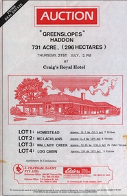
Document - Real Estate Flyers, J. Chatham, Daunt Pty. Ltd, Various years
... ..."boggy creek pub" curdie vale...[Jane Dyer (nee Chatham).16 June 2024] j chatham daunt auction "greenslopes" haddon "mindai park" cape clear kingston district the mill restaurant malmsbury "emu downs" beaufort "wattlw grove" mount mercer "rowan lodge" centennial hotel kensington "ben nevis estate" elmhurst "paddlesteamer lodge" wodonga place albury "woodlands" ararat lake wallace hotel, edenhope cremorne hotel newtown geelong terang hotel avoca hotel woori yallock hotel ballarat tram family restaurant victoria hotel woodend patersons siding restaurant and bar, ballarat the coorrabin motor inn, stawell clifton hill hotel, clifton hill albion hotel, kyabram "stag hotel" learmonth "osborne" rokewood shamrock hotel echuca willaura hotel, willaura "boggy creek pub" curdie vale shamrock hotel, dennington "mt elephant hotel/motel" derrinallum narmbool, ballarat brighton inn hotel khyat's posters real estate Hotels. ...The Ballarat-based firm, J Chatham and Co, serviced the Hotel Industry in Victoria, particularly Victoria’s Wimmera and Western Districts. Established by Jack { John} Chatham in 1956, The business was based at 7 Lydiard St South, Ballarat. As a regional hotel and motel broking specialist, Jack worked closely with other Ballarat businesses, including the Ballarat Brewery. On Jack's death in 1967, the business was taken over by his son, Philip, and renamed J Chatham Pty Ltd. The business continued to grow. Chatham House, the building the business operated from, and subsequently purchased and named, at 7 Lydiard St South, Ballarat still stands today. It was renamed by new owners in 2025 In the 1970's Philip opened a Melbourne branch in Dudley St, Nth Melbourne, The Melbourne branch, J Chatham and Daunt Pty Ltd, operated from 205 Victoria Parade, Fitzroy, a few blocks west of the Carlton United Brewery in the 1980s. In the late 1980s Philip's son, Andrew, joined the business, then called J Chatham, Daunt and Foley Pty Ltd. The business at this time operated from a terrace house [?Bouverie Street] Carlton near Grattan St. By 2005, the Daunt and Foley partnership had dissolved. In 2001 Philip predeceased his wife, Elizabeth Chatham (nee Holmes), a Director of the Company. His share of the business was inherited by Andrew. Elizabeth died in 2005. The business was sold in 2006. [Jane Dyer (nee Chatham).16 June 2024]Thirty-one real estate flyers j chatham, daunt, auction, "greenslopes" haddon, "mindai park" cape clear, kingston district, the mill restaurant malmsbury, "emu downs" beaufort, "wattlw grove" mount mercer, "rowan lodge", centennial hotel kensington, "ben nevis estate" elmhurst, "paddlesteamer lodge" wodonga place albury, "woodlands" ararat, lake wallace hotel, edenhope, cremorne hotel newtown geelong, terang hotel, avoca hotel, woori yallock hotel, ballarat tram family restaurant, victoria hotel woodend, patersons siding restaurant and bar, ballarat, the coorrabin motor inn, stawell, clifton hill hotel, clifton hill, albion hotel, kyabram, "stag hotel" learmonth, "osborne" rokewood, shamrock hotel echuca, willaura hotel, willaura, "boggy creek pub" curdie vale, shamrock hotel, dennington, "mt elephant hotel/motel" derrinallum, narmbool, ballarat, brighton inn hotel, khyat's, posters, real estate, hotels., restaurants -
Lakes Entrance Historical Society
Book, Buchan Primary School, Buchan 1905 School Centenary 1877-1977, 1977
... Booklet produced for the Buchan Primary School Centenary in 1977, includes lists of pupils and parents from 1914-1976 includes information on Buchan East, Buchan South, Murrindal, Gelantipy, Jackson Crossing, Butchers Ridge, W Tree, Boggy Creek, Tara Vale...Lakes Entrance Historical Society 4 Marine Parade Lakes Entrance gippsland Schools Settlers Topography Booklet produced for the Buchan Primary School Centenary in 1977, includes lists of pupils and parents from 1914-1976 includes information on Buchan East, Buchan South, Murrindal, Gelantipy, Jackson Crossing, Butchers Ridge, W Tree, Boggy Creek, Tara Vale Buchan 1905 School Centenary 1877-1977 Book Buchan Primary School ...Booklet produced for the Buchan Primary School Centenary in 1977, includes lists of pupils and parents from 1914-1976 includes information on Buchan East, Buchan South, Murrindal, Gelantipy, Jackson Crossing, Butchers Ridge, W Tree, Boggy Creek, Tara Valeschools, settlers, topography -
 Federation University Historical Collection
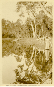
Postcard, Howard D. Bulmer, Reflections, Nowa Nowa, Lake Tyers, Victoria
... Tall eucalypts stand guard as you drive into this small village.The fresh waters of Boggy Creek and the tidal waters of Lake Tyers meet here. ...Tall eucalypts stand guard as you drive into this small village.The fresh waters of Boggy Creek and the tidal waters of Lake Tyers meet here. ...Nowa Nowa is located in Victoria on the Princes Highway between Lakes Entrance & Orbost. Tall eucalypts stand guard as you drive into this small village.The fresh waters of Boggy Creek and the tidal waters of Lake Tyers meet here. In the past its history was of logging. Black and white post card showing a lady in long skirt standing on the banks of a river with Australian eucalypts (gum tress) in the background and reflected in the water. nowa nowa, lake tyers, trees, river -
 Peterborough History Group
Plaque - Peterborough Golf Club Sponsor's Day Annual Golf Tournament
... Peterborough Golf Club sponsors day annual golf tournament winners are 2004 Roberts Farm Supplies, 2005 Schomberg Inn, 2006 Camperdown Removals, 2007 KC Electrica,l 2008 KC Electrica,l 2009 Loader Construction, 2010 Plozza's Pirates, 2011 Hampden Veterinary Clinic, 2012 Timboon Premix, 2013 Green Con Australia P/L, 2014 Ryan golf, 2015 WFI, 2016 Sungold Milk, 2017 Boggy Creek Pub....Peterborough Golf Club sponsors day annual golf tournament winners are 2004 Roberts Farm Supplies, 2005 Schomberg Inn, 2006 Camperdown Removals, 2007 KC Electrica,l 2008 KC Electrica,l 2009 Loader Construction, 2010 Plozza's Pirates, 2011 Hampden Veterinary Clinic, 2012 Timboon Premix, 2013 Green Con Australia P/L, 2014 Ryan golf, 2015 WFI, 2016 Sungold Milk, 2017 Boggy Creek Pub. Significant as it provides a snapshot of club sponsors over the years. ...This event was held as a thankyou to the sponsors of the golf club. Peterborough Golf Club sponsors day annual golf tournament winners are 2004 Roberts Farm Supplies, 2005 Schomberg Inn, 2006 Camperdown Removals, 2007 KC Electrica,l 2008 KC Electrica,l 2009 Loader Construction, 2010 Plozza's Pirates, 2011 Hampden Veterinary Clinic, 2012 Timboon Premix, 2013 Green Con Australia P/L, 2014 Ryan golf, 2015 WFI, 2016 Sungold Milk, 2017 Boggy Creek Pub.Significant as it provides a snapshot of club sponsors over the years.Trophy with a central sculpture of a golfer and pylons on either side with the winners' name platesA plaque on the front engraved with Peterborough Golf Club "Sponsors Day" Annual Golf Tournament.peterborough, peterborough golf club, golf tournament, sporting honour boards -
 Orbost & District Historical Society
black and white photographs, Jude, Ray, 1915 - 1969
... 3103.1 on back - " Orbost- Snowy River flats viaduct 22-2-1964 ARHS special train Ray Jude photo" 3103.2 - on back -" Orbost Snowy River flats viaduct A.R.H.S. special train 22.2.1969" 3103.3 - on back - " A.R.H.S. special across bridge between Waygara & Nowa Nowa 22-2-1964 3103.4 - on back - " Nowa Nowa Boggy Creek Bridge A.R.H.s. Orbost tour Ray Jude photo" 3103.5 - on back - " Orbost 22-2-1969 SM office & goods shed Ray Jude photo" 3103.6 - on back - " Orbost Railway Yards - 22 February 19369 Ray Jude photo" 3103.7 - on back - " Orbost May 27 -1936 Orbost Rail Station" 3103.8 - on front - caption - Unloading Ballast Orbost line near Newmerella 1915 - J. ...Orbost-railway East-Gippsland-railway Bairnsdale-Orbost-railway 3103.1 on back - " Orbost- Snowy River flats viaduct 22-2-1964 ARHS special train Ray Jude photo" 3103.2 - on back -" Orbost Snowy River flats viaduct A.R.H.S. special train 22.2.1969" 3103.3 - on back - " A.R.H.S. special across bridge between Waygara & Nowa Nowa 22-2-1964 3103.4 - on back - " Nowa Nowa Boggy Creek Bridge A.R.H.s. Orbost tour Ray Jude photo" 3103.5 - on back - " Orbost 22-2-1969 SM office & goods shed Ray Jude photo" 3103.6 - on back - " Orbost Railway Yards - 22 February 19369 Ray Jude photo" 3103.7 - on back - " Orbost May 27 -1936 Orbost Rail Station" 3103.8 - on front - caption - Unloading Ballast Orbost line near Newmerella 1915 - J. ...These photographs relate to the East Gippsland Railway. The Bairnsdale-Orbost railway was opened in 1916 to serve the agricultural and timber industry. Because of the decline in traffic and heavy operating costs, the line was finally closed in August, 1987. Orbost Railway Station was opened on Monday 10 April 1916 as the terminus of the Orbost railway line, and closed in 1987. The station was located on the west side of the Snowy River despite the town of Orbost being on the east side of the river, in order to save on the costs of a bridge over the river, which at the time had highly variable levels. These photographs are associated with the history of the Orbost-Bairnsdale railway line and therefore reflects the role that the rail line played in the social and economic history of Orbost.Seven black / white photographs and one postcard print.3103.1 on back - " Orbost- Snowy River flats viaduct 22-2-1964 ARHS special train Ray Jude photo" 3103.2 - on back -" Orbost Snowy River flats viaduct A.R.H.S. special train 22.2.1969" 3103.3 - on back - " A.R.H.S. special across bridge between Waygara & Nowa Nowa 22-2-1964 3103.4 - on back - " Nowa Nowa Boggy Creek Bridge A.R.H.s. Orbost tour Ray Jude photo" 3103.5 - on back - " Orbost 22-2-1969 SM office & goods shed Ray Jude photo" 3103.6 - on back - " Orbost Railway Yards - 22 February 19369 Ray Jude photo" 3103.7 - on back - " Orbost May 27 -1936 Orbost Rail Station" 3103.8 - on front - caption - Unloading Ballast Orbost line near Newmerella 1915 - J. Sullivan Colin ?orbost-railway east-gippsland-railway bairnsdale-orbost-railway -
 Peterborough History Group
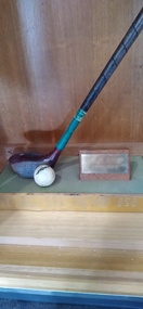
Souvenir - Bay of Islands Championshiop trophy
... The event was played on the Sunday of Grand Final weekend (except initially); Friday night traditionally was tea at Boggy Creek Pub and a Fishing Comp on Saturday. ...The event was played on the Sunday of Grand Final weekend (except initially); Friday night traditionally was tea at Boggy Creek Pub and a Fishing Comp on Saturday. ...Informal 12 hole golf event, played on Grand Final weekend. This event was started by a group of friends when there were few official golf tournaments played at Peterborough. The event was a stroke event with "mystery handicaps" ie you didn't know your handicap until you finished playing. The event was played on the Sunday of Grand Final weekend (except initially); Friday night traditionally was tea at Boggy Creek Pub and a Fishing Comp on Saturday. The name came about because three of the regular players, Ivan Voss, Bob Loader and R. McKendrick had a hut at the top of the dunes near Crofts Bay. They had a clinker boat on the beach as well. They subsequently built a house in Childers St. It ceased when the original participants were no longer able to play. The date of the first winner is 1980, last recorded winner is 1995. No longer played. further information required. Winners: 2nd August 1980 F. Virgona, 8th March 1981, R Case 25th September 1982, E Brierly 24th September 1983, R Mckendrick, 28th September 1984 D Stead, 28th September 1985 I Turnbull, 27th September 1986 J Charles, 26th September 1987 I Voss, 1988 no winner, 1989 F Carlin, 1990 B Turner, 1991 R Pollock, 1992 S McGuire 25th September 1993 B haskett 1st of october 1994 R pollock 30th of september 1995.Shortened golf driver and cracked ball mounted upon a wooden base with names engraved on metal surround.Engraved names, listed below, on metal plate affixed to the base.golf, peterborough golf club, golf tournment -
 Narre Warren and District Family History Group
Book, Narre Warren & District Family History Group Inc, Casey Cardinia Collection - Selected articles from the West Gippsland Trader - Volume 2, 2021
... Metung - A BEnd in the River 20 Sep 2012 The Royal Victorian Navy 6 Dec 2012 Tree Ferns to Blackberries 22 Nov 2012 Nowa Nowa Arm and Boggy Creek 18 Oct 2012 Home of the Baw Baw Frog 1 Nov 2012 Clearing the Hills 11 Oct 2012 The Loss of the Monumental City 4 Oct 2012 The Waterloo Township 13 Sep 2012 Birth of the Shire of Morwell 27 Sep 2012 George Black and Tarwin Meadows 9 Aug 2012 The Forgotten Corner of Gippsland 27 Mar 2008 Thomas William Harrison’s Family 3 Jul ? ...Metung - A BEnd in the River 20 Sep 2012 The Royal Victorian Navy 6 Dec 2012 Tree Ferns to Blackberries 22 Nov 2012 Nowa Nowa Arm and Boggy Creek 18 Oct 2012 Home of the Baw Baw Frog 1 Nov 2012 Clearing the Hills 11 Oct 2012 The Loss of the Monumental City 4 Oct 2012 The Waterloo Township 13 Sep 2012 Birth of the Shire of Morwell 27 Sep 2012 George Black and Tarwin Meadows 9 Aug 2012 The Forgotten Corner of Gippsland 27 Mar 2008 Thomas William Harrison’s Family 3 Jul ? ...Folder containing a table of contents and a selection of articles on Gippsland History by John Wells in the West Gippsland Trader Volume 2. The date the articles were published, and title of articles are listed below. 19 Jul 2012 Gembrook - an Attractive Little Town 7 Jun 2012 Getting Rid of the Wood 21 Mar 2013 Getting Into Orbost 13 Dec ? Metung - A BEnd in the River 20 Sep 2012 The Royal Victorian Navy 6 Dec 2012 Tree Ferns to Blackberries 22 Nov 2012 Nowa Nowa Arm and Boggy Creek 18 Oct 2012 Home of the Baw Baw Frog 1 Nov 2012 Clearing the Hills 11 Oct 2012 The Loss of the Monumental City 4 Oct 2012 The Waterloo Township 13 Sep 2012 Birth of the Shire of Morwell 27 Sep 2012 George Black and Tarwin Meadows 9 Aug 2012 The Forgotten Corner of Gippsland 27 Mar 2008 Thomas William Harrison’s Family 3 Jul ? Railway was Enormous Value to Swamp Country 19 Jun 2008 The Narre Warren Reserve Gates 12 Jun 2008 Heavy Harry is a Pretty Crook Giant 2 May ? Small Settlements on a Long Gippsland Track 5 Jun 2008 Land of Bullumwaal ot “Two Spears” 29 May 2008 Bigger Stops on a Long Road 15 May 2008 Crossing the Beautiful Snowy River 17 Apr 2008 I Remember Uncle Jack aqs an Old Man with Something Wrong 25 Jun 2009 The Murder of Cornelius Green 2 Jul 2009 Captain James Cook was too Late 5 Sep 2013 Oil and the Gippsland Lakes 18 Jun 2009 The Suburbs Around Sale 13 May 2010 The Boag Generations go on and on in Gippsland 27 May 2010 Underwater Coal at Yallourn Open Cut 4 Nov 2010 Narracan - the Aboriginal Name for Crow 23 Apr 2009 Driving Along the Omeo Track 2 Dec 2010 Remembering Those Old Wives’ Tales that we all Grew up with 16 Apr 2009 Myrtlebank, the Lost Suburb 16 Dec 2010 The Tragedy of the Loch Ard 9 Dec 2010 The Latrobe River Wharf on the East Bank 2 Jun 2011 Stony Creek Township’s Quiet Past 17 Mar 2011 William Barak Saw the Whites Take Over 5 May 2011 The Squatters’ Names Still Here 12 May 2011 The Diary of C.A.Ramsden (part one) 26 May 2011 South Coast Towns, 1891 19 May 2011 The Second Part of C.A.Ramsden’s Diary 28 Apr 2011 Squatter Names Still Remain on our Maps 13 Oct 2011 The Resting Place of 1131 Australians 29 Sep 2011 The Mitchell Valley Hopfields Oct 6 Lest We Forget - Lijssenthoek 10 Nov 2011 The Kurnai Men UNKNOWN The Returning of Captain Joe McLaughlin 6 Jun 2013 The Marlo Plains 16 May 2013 Bain’s Border Hotel 23 May ? The Mystery Map 30 May 2013 Finding a Road to the Jordan 4 Apr 2013 Rick Solves Mystery of American Captain 2 May ? The Haunted Hills - Tall Story or Truth? 18 Apr ? Interesting Times 15 Aug 2013 Remembering the Good Times 11 Dec 2014 The Old Sale Road - an Important Link 26 Mar 2015 Difficult to Know the Real Story 27 Nov 2014 The State’s Real Birthday 12 Sep 2013 The Herald 1925 2 Oct 2014 Beacons of Hope 9 Oct 2014 The Joys of Parenthood 6 Nov 2014 Aboriginal Life in Gippsland 30 Oct 2014 Growing up in Gippsland - Harriett Quigley 26 Sep 2013 The McHaffie Diary 19 Sep 2013 Outtrim - Once a Boom Town 10 Oct 2013 Happy Hundredth Birthday 4 Sep 2014 Many Towns Simply Disappeared 17 Jul 2014 Long Distance Farmer 25 Sep 2014 Sam Anderson - Gippsland’s First Farmer 28 Aug 2014 Local Oil 90 Years Ago 6 Mar 2014 A Fiery Summer - 1898 20 Feb 2014 The Corduroy Roads 8 May 2014 The Darkness Within 13 Mar ? Draining the Moe Swamp 1 May 2014 Any Ideas on Old Cannon? 3 Jul 2014 The Magnificent Snowy 14 Aug 2014 Two Gems in the Hills 19 Jun 2014 The Towns Down the Line 27 Feb 2014 State School 2502, Longwarry 18 Sep 2014 Lakes a Natural Fishing Ground 15 May 2014 Police Down the Ages 22May 2014 Iron Horse Came at a Walk 29 May 2014 Prom’s Early Attraction 12 Jun 2014 A Brief History of Meeniyan 5 Jun 2014 Ride on the Old Great Southern 26 Jun 2014 When Victoria Police Went on Strike 23 Apr 2015 Grandma’s Family Lost Heavily 11 Jun 2015 A Rail Journey Almost to Orbost 28 May 2015 Second Battle of Hastings 4 Jun 2015 Dandenong to Trafalgar by Train 18 Jun 2015 The Travelling Picture Man 19 Feb 2015 Water was a Problem 5 Feb 2015 Sandy Point Return Invokes Memories 24 Oct 2013 Lyrebirds Nesting in Trees? 12 Mar 2015 Supplying Melbourne’s Water 9 Aug 2015 They Shall Not Grow Old as we That Are Left 9 Jul 2015 National Parks a Valuable Resource 11 Sep 2014 Living Through the Best and the Worst 12 Feb 2015 Fishing is Part of Port’s History 26 Feb 2015 Chance Lost to Eliminate Rabbits 5 Mar 2015 Bloomfield - End of the Line, in a Way 11 Jul ? Emerald Primary School 22 Aug 2013 The Heartbreak Hills 17 Oct 2013 Port Albert, Land of Elephants 14 Nov 2013 Bullumwaal Land of Two Spears 28 Nov 2013 Coalville - the Forgotten Mine 5 Dec 2013 Early Travel with the Bishop 12 Dec 2013 Bishop Perry in Gippsland 19 Dec 2013 The Great Sale Goldfields Hoax 20 Mar 2014 A Chance to Dazzle the Kids 27 Mar 2014 More of Those Creeks and Rivers 3 Apr 2014 The Arctocephalus is With us Still 10 Apr 2014 Upper Yarra Dam had an Early Start UNKNOWN Harkaway’s Colorful History Contains Some Doubtful Tales UNKNOWN Berwick and the Peninsula in 1886non-fictiongippsland lakes, emerald primary school, meeniyan, upper yarra dam -
 Narre Warren and District Family History Group
Book, Narre Warren & District Family History Group Inc, Casey Cardinia Collection - Selected articles from the West Gippsland Trader - Volume 1, 2010
... Metung - A BEnd in the River 20 Sep 2012 The Royal Victorian Navy 6 Dec 2012 Tree Ferns to Blackberries 22 Nov 2012 Nowa Nowa Arm and Boggy Creek 18 Oct 2012 Home of the Baw Baw Frog 1 Nov 2012 Clearing the Hills 11 Oct 2012 The Loss of the Monumental City 4 Oct 2012 The Waterloo Township 13 Sep 2012 Birth of the Shire of Morwell 27 Sep 2012 George Black and Tarwin Meadows 9 Aug 2012 The Forgotten Corner of Gippsland 27 Mar 2008 Thomas William Harrison’s Family 3 Jul ? ...Metung - A BEnd in the River 20 Sep 2012 The Royal Victorian Navy 6 Dec 2012 Tree Ferns to Blackberries 22 Nov 2012 Nowa Nowa Arm and Boggy Creek 18 Oct 2012 Home of the Baw Baw Frog 1 Nov 2012 Clearing the Hills 11 Oct 2012 The Loss of the Monumental City 4 Oct 2012 The Waterloo Township 13 Sep 2012 Birth of the Shire of Morwell 27 Sep 2012 George Black and Tarwin Meadows 9 Aug 2012 The Forgotten Corner of Gippsland 27 Mar 2008 Thomas William Harrison’s Family 3 Jul ? ...Folder containing a table of contents and a selection of articles on Gippsland History by John Wells in the West Gippsland Trader Volume 1. The date the articles were published, and title of articles are listed below. 30 Oct 1997 Noojee Railway Line is an Engineering Classic 06 Nov 1997 Railways were a kiss of life for small settlements 13 Nov 1997 Erica was a timber and railway town 20 Nov 1997 People fought for railway line through to Stratford 27 Nov 1997 Tiny towns on the Wonthaggi line Vol 16 No 50 Cobungra station has some wild and beautiful country Vol 16 No 51 The explorers we have forgotten Vol 17 No 30 Hallam store became a place for men to gather 14 Feb 2002 Charlie Styles and his dull grey bedford bus Vol 26 No 10 Southern Community names 03 Aug 2006 A bit more Cloverlea 28 Sep 2006 Many airlines were keen to link wide brown land 26 Oct 2006 The ‘run’ at Top Plain 02 Nov 2006 Briagolong and the Garden of Eden 09 Nov 2006 I found a treasure in a milk bar 16 Nov 2006 Got five bob in your pocket, or should I say fifty cents? 23 Nov 2006 Trains were important in developing Gippsland 30 Nov 2006 The main line into Gippsland 07 Dec 2006 Alfred Howitt was a great man who deserves recognition Dec 2006? Christmas again? Already? 15 Feb 2007 The Great Southern Railway 08 Mar 2007 Expectations about water quality have changed since the old days 29 Mar 2007 Navigating by tree tops 12 Apr 2007 The Gippsland railway branch lines were very important in many ways 26 Apr 2007 Some community names from our northern hills 10 May 2007 Community names at the eastern end 24 May 2007 A shorter railway with big tonnages 31 May 2007 Cerberus was the guard dog 07 Jun 2007 Suburban stations in Gippsland 14 Jun 2007 How many Longwarry schools were there? 21 Jun 2007 Traralgon run was Hobson’s choice 28 Jun 2007 Maiden and Mormon and Happy Go Lucky 05 Jul 2007 Consider the humble rabbit trap 12 Jul 2007 Five acre blocks are everywhere 26 Jul 2007 Fencing, but not the Olympic variety 02 Aug 2007 Hanging the barbed wire fences 09 Aug 2007 Collecting and keeping the tucker we gathered 23 Aug 2007 The Longwarry Primary School itself 30 Aug 2007 Surveyors did it hard down Poowong way 06 Sep 2007 Back to the Poowong story 13 Sep 2007 A “think piece” or an indulgence? 20 Sep 2007 Longwarry “extra late final” 04 Oct 2007 Platina’s gone but not forgotten 11 Oct 2007 Robert Nield – Murray is back at it 18 Oct 2007 Spetts’ cottage at Walhalla 25 Oct 2007 Across the Alps to Omeo 08 Nov 2007 Where the gold lies deep in settlements that died 15 Nov 2007 Mines aplenty in the Walhalla area 22 Nov 2007 The other Violet Town – Jolly’s 29 Nov 2007 Mallacoota archaeology 06 Dec 2007 The Cassilis township or call it a settlement 13 Dec 2007 George Bass missed French Island 08 Feb 2008 David Mickle relates many stories of railway accidents 11Sep 2008 Lord Howe has a long history 18 Sep 2008 Quarry Hills important link for Berwick 25 Sep 2008 Tall ships, short ships, schooners and sloops 26 Jun 2008 We find Yanakie Jack again 03 Jul 2008 The well known Baw Baw Track 10 Jul 2008 Land of the moon? 07 Aug 2008 I loved eeling in the Tarago River 14 Aug 2008 Don’t let the red steer loose 28 Aug 2008 Yes, there is a place called Jumbuk 04 Sep 2008 The land of the big trees 23 Oct 2008 Still looking for Gippsland’s first town 13 Nov 2008 Journey to the bowels of the earth 30 Oct 2008 For King and Country – J.M. Laidlaw 06 Nov 2008 Jesse Huggett lived an adventurous life 22 Nov 2008 Churchill Island, yet again 04 Dec 2008 Bowman’s Track – if we can find it 11 Dec 2008 Draining of the great Koo Wee Rup Swamp 18 Dec 2008 The swampies had a go 02 Apr 2009 Looking for natural gas not offshore oil 21 Aug 2008 The Dreaded Summer Wildfire 17 Jul 2008 The Tangel (or Tanjil) hills District 7 Feb 2012 The Tanjil Area Goldrush 29 Aug 2013 Saddled and Spurred 9 Feb 2012 Many Racecourses Have Disappeared 16 Feb 2012 Fraser’s Hotel in Glenmaggie 23 Feb 2012 “Nothing Today, Jack!” on the Berwick Hill 1 Mar 2012 The Schnapper Point Line 8 Mar 2012 The Imaginary Town of Tambo 22 Mar 2012 The Tanjil Story Part One 15 Mar 2012 Inverloch Served Mosquito Fleet of Mis-Matched Boats 21 Jun 2012 The Last Bits of the Line 29 Mar 2012 “Gold Rush” to the Tanjil Area led to Reef Mining Companies 16 Aug 2012 New Life for Old Port Welshpool? 30 Aug 2012 The Capital of South Gippsland 28 Jun 2012 The Last Bits of the Line 5 Jul 2012 Ferdinand Von Mueller - a Man of Knowledge 12 Jul 2012 Stones in the Creek 19 Jul 2012 Gembrook - an Attractive Little Town 7 Jun 2012 Getting Rid of the Wood 21 Mar 2013 Getting Into Orbost 13 Dec ? Metung - A BEnd in the River 20 Sep 2012 The Royal Victorian Navy 6 Dec 2012 Tree Ferns to Blackberries 22 Nov 2012 Nowa Nowa Arm and Boggy Creek 18 Oct 2012 Home of the Baw Baw Frog 1 Nov 2012 Clearing the Hills 11 Oct 2012 The Loss of the Monumental City 4 Oct 2012 The Waterloo Township 13 Sep 2012 Birth of the Shire of Morwell 27 Sep 2012 George Black and Tarwin Meadows 9 Aug 2012 The Forgotten Corner of Gippsland 27 Mar 2008 Thomas William Harrison’s Family 3 Jul ? Railway was Enormous Value to Swamp Country 19 Jun 2008 The Narre Warren Reserve Gates 12 Jun 2008 Heavy Harry is a Pretty Crook Giant 2 May ? Small Settlements on a Long Gippsland Track 5 Jun 2008 Land of Bullumwaal ot “Two Spears” 29 May 2008 Bigger Stops on a Long Road 15 May 2008 Crossing the Beautiful Snowy River 17 Apr 2008 I Remember Uncle Jack aqs an Old Man with Something Wrong 25 Jun 2009 The Murder of Cornelius Green 2 Jul 2009 Captain James Cook was too Late 5 Sep 2013 Oil and the Gippsland Lakes 18 Jun 2009 The Suburbs Around Sale 13 May 2010 The Boag Generations go on and on in Gippsland 27 May 2010 Underwater Coal at Yallourn Open Cut 4 Nov 2010 Narracan - the Aboriginal Name for Crow 23 Apr 2009 Driving Along the Omeo Track 2 Dec 2010 Remembering Those Old Wives’ Tales that we all Grew up with 16 Apr 2009 Myrtlebank, the Lost Suburb 16 Dec 2010 The Tragedy of the Loch Ard 9 Dec 2010 The Latrobe River Wharf on the East Bank 2 Jun 2011 Stony Creek Township’s Quiet Past 17 Mar 2011 William Barak Saw the Whites Take Over 5 May 2011 The Squatters’ Names Still Here 12 May 2011 The Diary of C.A.Ramsden (part one) 26 May 2011 South Coast Towns, 1891 19 May 2011 The Second Part of C.A.Ramsden’s Diary 28 Apr 2011 Squatter Names Still Remain on our Maps 13 Oct 2011 The Resting Place of 1131 Australians 29 Sep 2011 The Mitchell Valley Hopfields Oct 6 Lest We Forget - Lijssenthoek 10 Nov 2011 The Kurnai Men UNKNOWN The Returning of Captain Joe McLaughlin 6 Jun 2013 The Marlo Plains 16 May 2013 Bain’s Border Hotel 23 May ? The Mystery Map 30 May 2013 Finding a Road to the Jordan 4 Apr 2013 Rick Solves Mystery of American Captain 2 May ? The Haunted Hills - Tall Story or Truth? 18 Apr ? Interesting Times 15 Aug 2013 Remembering the Good Times 11 Dec 2014 The Old Sale Road - an Important Link 26 Mar 2015 Difficult to Know the Real Story 27 Nov 2014 The State’s Real Birthday 12 Sep 2013 The Herald 1925 2 Oct 2014 Beacons of Hope 9 Oct 2014 The Joys of Parenthood 6 Nov 2014 Aboriginal Life in Gippsland 30 Oct 2014 Growing up in Gippsland - Harriett Quigley 26 Sep 2013 The McHaffie Diary 19 Sep 2013 Outtrim - Once a Boom Town 10 Oct 2013 Happy Hundredth Birthday 4 Sep 2014 Many Towns Simply Disappeared 17 Jul 2014 Long Distance Farmer 25 Sep 2014 Sam Anderson - Gippsland’s First Farmer 28 Aug 2014 Local Oil 90 Years Ago 6 Mar 2014 A Fiery Summer - 1898 20 Feb 2014 The Corduroy Roads 8 May 2014 The Darkness Within 13 Mar ? Draining the Moe Swamp 1 May 2014 Any Ideas on Old Cannon? 3 Jul 2014 The Magnificent Snowy 14 Aug 2014 Two Gems in the Hills 19 Jun 2014 The Towns Down the Line 27 Feb 2014 State School 2502, Longwarry 18 Sep 2014 Lakes a Natural Fishing Ground 15 May 2014 Police Down the Ages 22May 2014 Iron Horse Came at a Walk 29 May 2014 Prom’s Early Attraction 12 Jun 2014 A Brief History of Meeniyan 5 Jun 2014 Ride on the Old Great Southern 26 Jun 2014 When Victoria Police Went on Strike 23 Apr 2015 Grandma’s Family Lost Heavily 11 Jun 2015 A Rail Journey Almost to Orbost 28 May 2015 Second Battle of Hastings 4 Jun 2015 Dandenong to Trafalgar by Train 18 Jun 2015 The Travelling Picture Man 19 Feb 2015 Water was a Problem 5 Feb 2015 Sandy Point Return Invokes Memories 24 Oct 2013 Lyrebirds Nesting in Trees? 12 Mar 2015 Supplying Melbourne’s Water 9 Aug 2015 They Shall Not Grow Old as we That Are Left 9 Jul 2015 National Parks a Valuable Resource 11 Sep 2014 Living Through the Best and the Worst 12 Feb 2015 Fishing is Part of Port’s History 26 Feb 2015 Chance Lost to Eliminate Rabbits 5 Mar 2015 Bloomfield - End of the Line, in a Way 11 Jul ? Emerald Primary School 22 Aug 2013 The Heartbreak Hills 17 Oct 2013 Port Albert, Land of Elephants 14 Nov 2013 Bullumwaal Land of Two Spears 28 Nov 2013 Coalville - the Forgotten Mine 5 Dec 2013 Early Travel with the Bishop 12 Dec 2013 Bishop Perry in Gippsland 19 Dec 2013 The Great Sale Goldfields Hoax 20 Mar 2014 A Chance to Dazzle the Kids 27 Mar 2014 More of Those Creeks and Rivers 3 Apr 2014 The Arctocephalus is With us Still 10 Apr 2014 Upper Yarra Dam had an Early Start UNKNOWN Harkaway’s Colorful History Contains Some Doubtful Tales UNKNOWN Berwick and the Peninsula in 1886non-fictionwonthaggi railway line towns, great southern railway, baw baw track -
 Orbost & District Historical Society
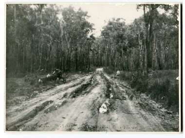
black and white photograph, 1924
... Dairy farming still plays an essential role in the township. this is a pictorial record of the Princes Highway, the main road from East Gippsland to the New South Wales border. road Princes-Highway Bellbird-Creek-1924 on front - "Main Rd near Bellbird 1924" A large black / white photograph of a very wet and boggy bush road. black and white photograph ...This photograph shows the main road near Bellbird, East Gippsland, in 1924. This road would have been the Princes Highway, a main thoroughfare through to New South Wales. Bellbird Creek is a small rural location between Orbost and Cann River. There was no township at Cabbage Tree at this time. The Cabbage Tree Creek township was established to support the booming timber industry of the mid 20th century. Five timber mills worked full time supporting the families that were drawn to the area's wealth of natural resources. Nestled on the banks of the Cabbage Tree Creek, the township was built by those mills to house their workers. Today although the timber mills have disappeared, some of the buildings still remain. Little now remains to remind of the saw-milling history apart from photographs and some relics - a boiler and a brick furnace. There was also a thriving agricultural community farming dairy, beef, seed beans and fresh peas and beans that were sent to the Victoria Market in Melbourne. Dairy farming still plays an essential role in the township. this is a pictorial record of the Princes Highway, the main road from East Gippsland to the New South Wales border.A large black / white photograph of a very wet and boggy bush road.on front - "Main Rd near Bellbird 1924"road princes-highway bellbird-creek-1924 -
 Wodonga & District Historical Society Inc
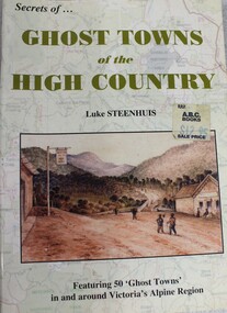
Book - Ghost Towns of the High Country, Luke Steenhuis, 1998
... Wodonga & District Historical Society Inc Hut 97, Bonegilla Migrant Experience, 132 Bonegilla Road Bonegilla the-murray ghost towns high country victoria pioneers history victoria Stories and information about former towns in and around Victoria's Alpine Region. Towns include Boggy Creek, Brandy Creek, Brocket, Brookville, Buckland, Buckland Upper, Bulgoback, Bulltown, Hogtown, Bullumwaal, Canvastown, Cassilis, Cobbannah, Copenhagen, Dargo High Plains, Dartmouth, Deptford, Gibbo River, Gladstone, Glen Dart, Glen Valley, Glen Wills, Good Luck Creek, Granite Flat, Grant, Hinnomunjie, Howittville, Jeff Davis, Lightning Creek, Louisville, Mayford, Merrijig Creek, Mitchelldale, Mount Elmo, Nugong, Sassafras, Saltpetre, Staleyville, Stirling, Store Creek, Summer Hill, Sunnyside, Tabberabbera, Talbotville, Thiel Town, Tongio West, Waterford, Wentworth River, Winchester, Wombat, Wongungarra, Zulu Creek. ...Stories and information about former towns in and around Victoria's Alpine Region. Towns include Boggy Creek, Brandy Creek, Brocket, Brookville, Buckland, Buckland Upper, Bulgoback, Bulltown, Hogtown, Bullumwaal, Canvastown, Cassilis, Cobbannah, Copenhagen, Dargo High Plains, Dartmouth, Deptford, Gibbo River, Gladstone, Glen Dart, Glen Valley, Glen Wills, Good Luck Creek, Granite Flat, Grant, Hinnomunjie, Howittville, Jeff Davis, Lightning Creek, Louisville, Mayford, Merrijig Creek, Mitchelldale, Mount Elmo, Nugong, Sassafras, Saltpetre, Staleyville, Stirling, Store Creek, Summer Hill, Sunnyside, Tabberabbera, Talbotville, Thiel Town, Tongio West, Waterford, Wentworth River, Winchester, Wombat, Wongungarra, Zulu Creek.non-fictionStories and information about former towns in and around Victoria's Alpine Region. Towns include Boggy Creek, Brandy Creek, Brocket, Brookville, Buckland, Buckland Upper, Bulgoback, Bulltown, Hogtown, Bullumwaal, Canvastown, Cassilis, Cobbannah, Copenhagen, Dargo High Plains, Dartmouth, Deptford, Gibbo River, Gladstone, Glen Dart, Glen Valley, Glen Wills, Good Luck Creek, Granite Flat, Grant, Hinnomunjie, Howittville, Jeff Davis, Lightning Creek, Louisville, Mayford, Merrijig Creek, Mitchelldale, Mount Elmo, Nugong, Sassafras, Saltpetre, Staleyville, Stirling, Store Creek, Summer Hill, Sunnyside, Tabberabbera, Talbotville, Thiel Town, Tongio West, Waterford, Wentworth River, Winchester, Wombat, Wongungarra, Zulu Creek.ghost towns, high country victoria, pioneers, history victoria