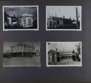
Showing 101 items matching "brick facade"
-
 Melbourne Tram Museum
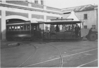
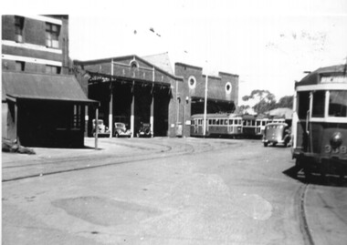
Photograph - Cable tram leaving the Nicholson Street car house, 1930s
... ...brick facade...The car house with upstairs offices has a brick facade. The double storey corruguted iron building in the background is the tram construction factory and workshop. ...The car house with upstairs offices has a brick facade. The double storey corruguted iron building in the background is the tram construction factory and workshop. ...Cable tram sets were moved onto Nicholson Street from the car house using horses or tractors. The grip mechanism sat high on the dummy floor when in the car house and was only lowered into the cable tunnel only when the tram was on the street. Here the gripman and conductor are standing in the dummy in their M&MTB issued uniforms. The car house with upstairs offices has a brick facade. The double storey corruguted iron building in the background is the tram construction factory and workshop. Yields information about Nicholson Street car houseBlack and white photograph with no note on rearcable tram sets, car house, tractors, horses, the grip, dummy floor, gripman, conductor, m&mtb issued uniforms, brick facade, corruguted iron building, tram construction factory, workshop, nicholson street -
 Stawell Historical Society Inc
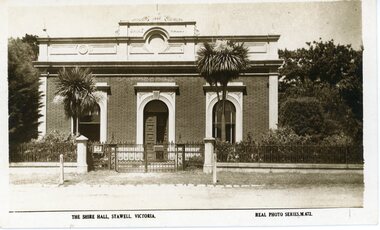
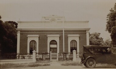
Photograph, Stawell Shire Hall 1866
... The building originally had a brick facade as seen in this photo. The post card also shows the changes in vegetation around the building. ...The building has a brick facade with trees in the background. In front of the two arched front windows of the building are two tall Dracaena's either side of the entrance. ...The building originally had a brick facade as seen in this photo. The post card also shows the changes in vegetation around the building. ...Post card of the Stawell Shire Hall built 1866. The Shire Hall in Longfield Street Stawell has seen many changes over time. The building originally had a brick facade as seen in this photo. The post card also shows the changes in vegetation around the building. In front of the two arched front windows of the building are two tall Dracaena's possible planted in c 1890's. The decorative fence was not in very early photographs of the building but appears in photographs around c 1890. The post card is located in Albun 14, p.9.Black & white post card of the Stawell Shire Hall. The building has a brick facade with trees in the background. In front of the two arched front windows of the building are two tall Dracaena's either side of the entrance. There is a decorative fence with posts either side of the entrance gates to the building. The post card is located in Albun 14, p.9.The Shire Hall, Stawell Victoria. Real Photo Series. M. 672. on the back Valentines real photo series POST CARD branches Sydney London Dundee Capetown Montreal Toronto all in a box. Published by the Valentine & Sons Publishing Co.Ltd. Melbourne, Sydney & Brisbane.stawell -
 Kew Historical Society Inc
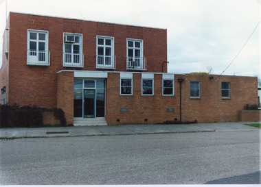
Photograph - Former Kew Police Station : East facing facade, 1996
... Exterior view of the east facing red brick facade of the former Kew Police Station in High Street, Kew....They are historically and architecturally significant to the State of Victoria because Watson and Harvey's designs exhibit diversity in integrating civil offices, they accommodate the apex of road junctions, and they demonstrate a departure from the contemporaneously favoured High Victorian Classical to the Queen Anne style in the design of civic buildings. kew court house public offices -- kew (vic) kew police station Exterior view of the east facing red brick facade of the former Kew Police Station in High Street, Kew. ...A civic campaign for new public offices developed in Kew in the 1880s. After much deliberation, the location chosen was the junction of Bulleen and Cotham Roads. The buildings were designed by George Watson and John Henry Harvey, architects within the Department of Public Works (Victoria). Building was commenced in 1887, and after one year, the buildings were opened. The Post Office was transferred to the new Commonwealth Government in 1901. The Police Station and Court House, sold by the Victorian Government to the City of Boroondara in 2007, are now a community cultural centre and performing arts venue.The buildings were listed on the Victorian Heritage Register Register (HO885) in 1991. They are historically and architecturally significant to the State of Victoria because Watson and Harvey's designs exhibit diversity in integrating civil offices, they accommodate the apex of road junctions, and they demonstrate a departure from the contemporaneously favoured High Victorian Classical to the Queen Anne style in the design of civic buildings.Exterior view of the east facing red brick facade of the former Kew Police Station in High Street, Kew.kew court house, public offices -- kew (vic), kew police station -
 Kew Historical Society Inc
Photograph - Former Kew Court House : High Street elevation, 1996
... Exterior view of the north facing red brick facade of the former Court House and Police Station in High Street, Kew....They are historically and architecturally significant to the State of Victoria because Watson and Harvey's designs exhibit diversity in integrating civil offices, they accommodate the apex of road junctions, and they demonstrate a departure from the contemporaneously favoured High Victorian Classical to the Queen Anne style in the design of civic buildings. kew court house public offices -- kew (vic) kew police station Exterior view of the north facing red brick facade of the former Court House and Police Station in High Street, Kew. ...A civic campaign for new public offices developed in Kew in the 1880s. After much deliberation, the location chosen was the junction of Bulleen and Cotham Roads. The buildings were designed by George Watson and John Henry Harvey, architects within the Department of Public Works (Victoria). Building was commenced in 1887, and after one year, the buildings were opened. The Post Office was transferred to the new Commonwealth Government in 1901. The Police Station and Court House, sold by the Victorian Government to the City of Boroondara in 2007, are now a community cultural centre and performing arts venue.The buildings were listed on the Victorian Heritage Register Register (HO885) in 1991. They are historically and architecturally significant to the State of Victoria because Watson and Harvey's designs exhibit diversity in integrating civil offices, they accommodate the apex of road junctions, and they demonstrate a departure from the contemporaneously favoured High Victorian Classical to the Queen Anne style in the design of civic buildings.Exterior view of the north facing red brick facade of the former Court House and Police Station in High Street, Kew.kew court house, public offices -- kew (vic), kew police station -
 Lakes Entrance Historical Society
Photograph - Tambo Shire Office, Tambo Shire, 1994 c
... Colour photograph of the old Tambo Shire Office, shows additions and a brick facade which was added to the original building around 1960's. ...Lakes Entrance Historical Society 4 Marine Parade Lakes Entrance gippsland Also second identical copy Buildings Administration Colour photograph of the old Tambo Shire Office, shows additions and a brick facade which was added to the original building around 1960's. ...Also second identical copyColour photograph of the old Tambo Shire Office, shows additions and a brick facade which was added to the original building around 1960's. Bruthen Victoria buildings, administration -
 Kilmore Historical Society
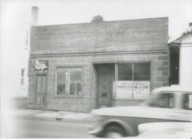
Photograph, 33-35 Sydney Street, 1950's?
... 18cm x 13cm black and white photograph of a single story building with dark brick facade. Two occupants are using the building, "Heatane"and Eric W. ...Shopfront Storefront Retail store Written on the back: Shop in space where Drummonds garage. now used by Wilson Partners. 18cm x 13cm black and white photograph of a single story building with dark brick facade. Two occupants are using the building, "Heatane"and Eric W. ...Shop in space where Drummonds Garage, now used by Wilson Partners Real Estate.18cm x 13cm black and white photograph of a single story building with dark brick facade. Two occupants are using the building, "Heatane"and Eric W. Tulloh Barrister Solicitor.Written on the back: Shop in space where Drummonds garage. now used by Wilson Partners.shopfront, storefront, retail store -
 Surrey Hills Historical Society Collection
Photograph, Denholm's Garage, 209 Union Road, Surrey Hills
... A back and white photograph of a garage called Union Motor Garage. It has a brick facade, with an arched window either side of the driveway. ....:: A back and white photograph of a garage called Union Motor Garage. It has a brick facade, with an arched window either side of the driveway. ...Fred Lyons (cab driver) and Dave Denholm (garage proprietor) worked together in a business servicing cars and providing vehicles for weddings etc. The photo came as part of a donation of photos related to Fred Lyons, his family and business. The building and automotive business was taken over and became J & V Warren-Smith Auto Service. In 2018 it is managed by John and Val's son Phillip and is believed to be the only business in the Union Road shops with a continuous history of use.A back and white photograph of a garage called Union Motor Garage. It has a brick facade, with an arched window either side of the driveway. A petrol bowser stands in front of each window. There is a car in the driveway.On small card: Union Motor Garage / D. B. Denholm, Proptr. / 209 UNION ROAD, SURREY HILLS / Phone Box Hill 959 / AUSTIN OAKLAND / PONTIAC DOUGLAS.::denholm's garage, union motor garage, union road, surrey hills, (mr) dave b. denholm, (mr) fred lyons, petrol stations, petrol pumps, j & v warren-smith auto service -
 Glen Eira Historical Society
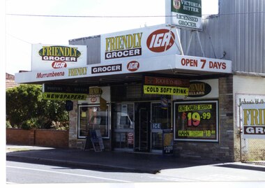
Photograph, Murrumbeena Road, 235, Murrumbeena, 2001
... The property features a flat roof awning, corrugated parapet, irregular multi-coloured slate tile and brick facade and extensive advertising over the front and side of the building plus on the gate to the right....The property features a flat roof awning, corrugated parapet, irregular multi-coloured slate tile and brick facade and extensive advertising over the front and side of the building plus on the gate to the right. ...Originally labelled "Beauville Estate, Established 1936, Still Thriving 65 years on, 10th March 2001", the Beauville Estate Album contains colour photographs of houses in the Estate. They were taken around the time of the Beauville Estate’s 65th Heritage Celebration held on 10/03/2001 and donated to the Caulfield Historical Society shortly afterwards. Photographer unknown. No. 235 is NOT covered by the Heritage Overlay HO12.Colour photograph of a supermarket. The property features a flat roof awning, corrugated parapet, irregular multi-coloured slate tile and brick facade and extensive advertising over the front and side of the building plus on the gate to the right.Murumbeena FRIENDLY GROCER IGA / OPEN 7 DAYS / NEWSPAPERS / COLD SOFT DRINKmurrumbeena, architectural styles, 1930's, inter war style, a.v. jennings, av jennings, jennings, beauville estate, murrumbeena road, commercial establishments, shops, supermarkets, sir albert victor jennings, a v jennings construction co, beauville estate heritage area, glen eira city council, architectural features, jennings group limited, land subdivision, beauville historic area, brick shops, parapets, advertising signs, murumbeena friendly grocer iga -
 Kew Historical Society Inc
Photograph, 'Molina', Charles Street, Kew, circa 1965, c. 1965
... The south facing, polychrome brick facade of Molina, which was between c.1873-1908 the location of the private Kew High School. ...The south facing, polychrome brick facade of Molina, which was between c.1873-1908 the location of the private Kew High School. ...This work forms part of the collection assembled by the historian Dorothy Rogers, that was donated to the Kew Historical Society by her son John Rogers in 2015. The manuscripts, photographs, maps, and documents were sourced by her from both family and local collections or produced as references for her print publications. Many were directly used by Rogers in writing ‘Lovely Old Homes of Kew’ (1961) and 'A History of Kew' (1973), or the numerous articles on local history that she produced for suburban newspapers. Most of the photographs in the collection include detailed annotations in her hand.The Rogers Collection provides a comprehensive insight into the working habits of a historian in the 1960s and 1970s. Together it forms the largest privately-donated collection within the archives of the Kew Historical Society.The south facing, polychrome brick facade of Molina, which was between c.1873-1908 the location of the private Kew High School. The house was renamed Merritt House in 1925. It is now part of Trinity Grammar School.Merritt house. Old Kew High School. Now Trinity Grammar School.molina, merritt house, trinity grammar school, kew high school, dorothy rogers, kew -
 Sunbury Family History and Heritage Society Inc.
Photograph, Rosa McCall, c2021
... A non-digital coloured photograph of a double fronted Edwardian cottage with a red brick facade with cream weatherboards as main structure. ...Joseph of the Sacred Heart Catholic Church A non-digital coloured photograph of a double fronted Edwardian cottage with a red brick facade with cream weatherboards as main structure. ...The Edwardian building was opened on the 23rd January 1916 and was blessed by Archbishop Mannix. It was the convent for the Sisters of St. Joseph of the Sacred Heart and the building functioned as a convent in Sunbury for the next 109 years. It closed on 13th July 2025. For many years the Sisters of St. Joseph were teachers at Our Lady of Mount Carmel School. It was located in Macedon Street opposite the Sunbury Global Learning Centre.A non-digital coloured photograph of a double fronted Edwardian cottage with a red brick facade with cream weatherboards as main structure. The pitched roof is covered with orange ceramic tiles. A white cross is above the front porch near the front door.sunbury convent, our lady of mount carmel catholic church, sisters of st. joseph of the sacred heart, catholic church -
 Stawell Historical Society Inc
Photograph, Stawell Shire Hall 1866 in Longford Street c 1920
... A small black & white photo of the Stawell Shire Hall with its brick facade with a parapet top. The entrance doorway in the centre with windows each side. ...A small black & white photo of the Stawell Shire Hall with its brick facade with a parapet top. The entrance doorway in the centre with windows each side. ...Front view of Stawell Shire Hall in Longford Street with wrought iron fence and 1920's motor vehicle parked outside. The photograph taken in 1949 was donated by Mr. F. M. Mortyn who was Secretary of the Stawell Shire from 1947 - 1960. A small black & white photo of the Stawell Shire Hall with its brick facade with a parapet top. The entrance doorway in the centre with windows each side. In front a wrought iron fence. The gate of the fence is painted white. A 1920's motor vehicle is parked out the front to the right of the Shire Hall. Stawell Shire Hall 1949.stawell -
 Port of Echuca
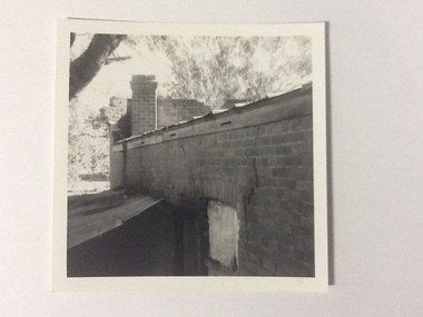
Black and white photograph, 1975
... Part of the back of the front brick facade is visible behind a brick chimney. ...Part of the back of the front brick facade is visible behind a brick chimney. ...The brick old Murray River Sawmill office was demolished around 1975. This photograph is of the side of the building taken from behind. It shows a corrugated lean-to and a window or door way that appears to be blocked off. There is a large crack in the brick work wall beside this doorway. Part of the back of the front brick facade is visible behind a brick chimney. This relates to photographs P000106, P000107.Sawmills in the Echuca area were historically and socially significant being a large employer in the area. The Murray River sawmill was one of the biggest and longest operating sawmills in the area.Black and white photograph of the old Murray River Sawmills building, taken from the road. Shows view from a rear side, with a window and corrugated iron lean-to. Part of back of facade can be seen as well as the chimney.On back of the photograph in pencil "Old Murray R Sawmills bldg, in from road." In black pen "Old office demolished c.1975" stamped in blue ink "0932"murray river sawmills, echuca, sawmills, echuca, vicotria, pullicino, j -
 Port of Echuca
Colour Photograph, Approx.1979
... "The burnt section of the school was rebuilt along the lines of the original building and today the red brick facade and bell tower are a feature of the Hare Strett skyline" (Echuca Stetchbook, Blyth, I, 1978, p.32...."The burnt section of the school was rebuilt along the lines of the original building and today the red brick facade and bell tower are a feature of the Hare Strett skyline" (Echuca Stetchbook, Blyth, I, 1978, p.32. ...This building opened on 19 October 1874. The front section of this building including 8 classrooms, the headmaster's office and the bell tower were destroyed by fire 27 February 1890. "The burnt section of the school was rebuilt along the lines of the original building and today the red brick facade and bell tower are a feature of the Hare Strett skyline" (Echuca Stetchbook, Blyth, I, 1978, p.32.Henry Hopwood, founder of Echuca, saw the need to establish a national school to educate the children of Echuca. The first National School opened in October 1858 in a framed tent. Construction of the first brick school house began in 1859 on the site of the original Post Office in Hare street. Later the site changed to the southern end of Hare street and this building was opened 19 October 1874. The school stayed here until a new school was built on the old Echuca Technical School site.Colour photograph (post-card size) of Echuca Primary School, 208, showing the eastern facade including the bell tower, taken from the eastern side of High street. Printed on the reverse:"this paper manufactured by Kodak"echuca-primary schools, echuca-historical buildings -
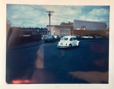
 Melbourne Tram Museum
Photograph - Black & White Photograph/s, Keith Kings, 23/10/1946
... Shows the depot starters office in front of the main building, the brick facades and a number of trams parked in front of the second sheet. ...Shows the depot starters office in front of the main building, the brick facades and a number of trams parked in front of the second sheet. ...Black and white photograph of the front of MMTB Hawthorn Depot, 23/10/1946, prior to the reconstruction of the front of both depots. Shows the depot starters office in front of the main building, the brick facades and a number of trams parked in front of the second sheet. No. 339 is on the depot lead. See image i2 for the rear of the photograph giving details. Notes it is on the 3rd day of a tram and train strike. Keith Kings photograph No. A(m)(2) Printed on Kodak Xralife paper.trams, tramways, hawthorn tram depot, depots, tram 339, w2 class -
 Ararat & District Historical Society (operating the Langi Morgala Museum)
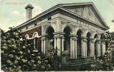
Postcard
... The building facade is brick with a white painted front....The building facade is brick with a white painted front. Postcard Postcard Postcard ...Colourised postcard depicting the Shire Hall Ararat. The building facade is brick with a white painted front.In gold print of the front of the postcard is written Shire Hall Ararat. -
 Kew Historical Society Inc
Photograph - Former Kew Town Hall, Walpole Street, 1970
... The photograph, from August 1970 shows the detailing of the Italianate rendered-brick facade, added in the 1880s when the hall was renovated. ...The photograph, from August 1970 shows the detailing of the Italianate rendered-brick facade, added in the 1880s when the hall was renovated. ...The Municipality of Kew was granted independence in 1860. It was declared a borough in 1863, a town in 1910 and a city in 1921. In 1994, Kew was amalgamated into the new City of Boroondara.Black and white photographic positive of the front of the (former) Kew Town Hall in Walpole Street between High Street and Malmsbury Street, on the west side where Woolworth's supermarket now stands. The photograph, from August 1970 shows the detailing of the Italianate rendered-brick facade, added in the 1880s when the hall was renovated. The earliest building on the site was the Kew Athenaeum Hall (built 1860) which was purchased by Kew Council in 1865. The Town Hall was sold to Woolworth's and subsequently demolished in 1972 when the civic offices were transferred to a new building on the corner of Charles Street and Cotham Road."Old Kew Town Hall / Walpole St / Aug 1970/ Gift of Stewart West 1990"kew town hall -- walpole street, local government -- kew, civic buildings -- kew (vic.), town halls -- melbourne (vic.) -
 Kew Historical Society Inc
Photograph - Former Kew Town Hall, Walpole Street, 1972
... The photograph, taken in February 1972, shows the detailing of the Italianate rendered-brick facade, added in the 1880s when the hall was renovated. ...The photograph, taken in February 1972, shows the detailing of the Italianate rendered-brick facade, added in the 1880s when the hall was renovated. ...The Municipality of Kew was granted independence in 1860. It was declared a borough in 1863, a town in 1910 and a city in 1921. In 1994, Kew was amalgamated into the new City of Boroondara. In 1960, a new Town Hall in Cotham Road was opened. The Municipal Offices that had remained in the former Town Hall in Walpole Street until it was moved to the new Civic Centre on the corner of Cotham Road and Charles Street in 1972.This is a rare and important colour photograph of the Kew Municipal Offices (former Town Hall) taken on 11/2/1972 in the year that the building was demolished and replaced by a Safeway Supermarket.Colour photographic positive (polaroid) of the front of the (former) Kew Town Hall in Walpole Street between High Street and Malmsbury Street, on the west side where Woolworth's supermarket now stands. The photograph, taken in February 1972, shows the detailing of the Italianate rendered-brick facade, added in the 1880s when the hall was renovated. The earliest building on the site was the Kew Athenaeum Hall (built 1860) which was purchased by Kew Council in 1865. The Town Hall was sold to Woolworth's and subsequently demolished in 1972 when the civic offices were transferred to a new building on the corner of Charles Street and Cotham Road.kew town hall -- walpole street, local government -- kew, town halls -- melbourne (vic.) -
 Kew Historical Society Inc
Photograph - High Street, Kew, 1960-65
... Stretching behind the brick facade is an extensive building that must have housed the printing works. ...Stretching behind the brick facade is an extensive building that must have housed the printing works. ...The borders of the main components of Kew and Kew East have not always conformed to current boundaries. In the past this photograph has been labelled as East Kew, whereas for most of the twentieth century the site has been within Kew's borders. The purpose of the photograph is unrecorded yet it has value in that it shows those businesses who occupied this site in Kew during the early 1960s.This small photograph is significant as it shows the location of and building used by WD Vaughan, former Mayor of Kew who was a successful newspaper proprietor in Melbourne.Small polaroid colour positive of High Street in Kew, probably in the 1960s. From left we can see the brick viaduct covering the tracks of what was once the Outer Circle Railway. Behind this brick wall, Dunnings Timber Yard was situated. At the end of the walls of the viaduct there is an entrance to a walkway [now the Anniversary Trail], which once provided access to Windsor Avenue, and also to the East Kew Station (now demolished and part of the Outer Circle Railway Reserve). On the other side of this walkway is a cream brick building (demolished) occupied at this time by WD Vaughan Pty Ltd, printer and publisher of the Kew Advertiser (newspaper). Stretching behind the brick facade is an extensive building that must have housed the printing works. Beside Vaughan's, there is a large building (demolished) housing at that time an estate agent named AJ Kennedy. This area is now separated by kerbing.High St East Kew / Corner of Harp Rd. / Looking South -
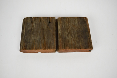 National Wool Museum
Functional object - Floorboards, 1994
... This framework was filled with lightweight panels to enclose workplaces and removed in some parts to establish courtyards, atriums and streets. The brick facades were redefined with new doors and double-glazed windows in proportion to original fenestration. ...This framework was filled with lightweight panels to enclose workplaces and removed in some parts to establish courtyards, atriums and streets. The brick facades were redefined with new doors and double-glazed windows in proportion to original fenestration. ...Two short sections of flooring cut for distribution during Deakin Universities ‘Open Day’ in December 1994. This was during the conversion of Dalgety Wool Store to Deakin University’s Woolstore Campus. These small pieces of timber are part of Geelong’s history and were salvaged from the Dalgety Woolstores during the renovations. Hundred of meters of ironbark, red gum, pine and other timbers, some more than a century old, were reclaimed from the site and have been recycled as furniture and featured building materials for the woolstore campus. The old brick stores, located on a formerly neglected section of the Corio Bay shoreline, now house the administration and chancellery, architecture and building schools, information technology services, the student union, a cafeteria and, as the focal facility, a Great Hall seating 1500 people and acoustically tuned for symphony orchestras. The refit was developed from the existing grid of substantial timber columns and beams extending over 52,000 square metres. This framework was filled with lightweight panels to enclose workplaces and removed in some parts to establish courtyards, atriums and streets. The brick facades were redefined with new doors and double-glazed windows in proportion to original fenestration. Bright colours and industrial finishes identify the new insertions.Square sections of redgum lumber cut into floorboards. The sides of the lumber have a grove cut on one side and a matching section to fit within this groove on the other side. This has been done to ensure the floorboards have a tight and consistent fit with one another. The bottom of the lumber also has an additional grove running through the middle of the redgum. On top, one of the sections of lumber has three nail holes, which travel all the way through to the bottom of the wood.deakin university, dalgety wool store, red gum -
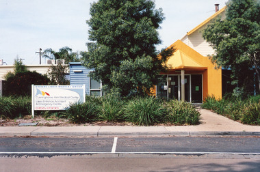 Lakes Entrance Historical Society
Photograph - Medical Centre, Holding M, 2009
... Appears to be brick or concrete slab facade painted bright yellow. Information sign in native plant garden, brick pathways. ...Appears to be brick or concrete slab facade painted bright yellow. Information sign in native plant garden, brick pathways. ...Date made September 2009 Site building was originally (games room) part of caravan park Also one other colour photograph closer view of front entrance doorway.Colour photograph of the front entry to Cunninghame Arm Medical Centre at 8 Whiters Street. Appears to be brick or concrete slab facade painted bright yellow. Information sign in native plant garden, brick pathways. Lakes Entrance Victoriamedical facilities, local history -
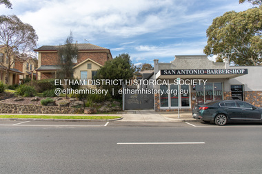
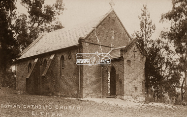 Eltham District Historical Society Inc
Negative - Photograph, St Mary's Roman Catholic Church, Eltham, c.1910
... Note the extensive cracking of the mortar and bricks in the front facade near the portico entrance. ...Eltham District Historical Society Inc 728 Main Rd Eltham melbourne Note the extensive cracking of the mortar and bricks in the front facade near the portico entrance. ...Note the extensive cracking of the mortar and bricks in the front facade near the portico entrance. The original St Mary’s Roman Catholic Church (1865-1912) was built of clay brick with buttress walls and a slate roof on the corner of Fordhams Road and Maria Street (Main Road), Eltham South, opposite the present-day Wingrove Park. It was blessed on September 3, 1865. With the arrival of the railway in 1901 and the town centre moving closer to the station, the decision was made to relocate the site of the church to its present-day location on Henry Street at the corner of Main Road. A new timber weatherboard church, also called St Mary's was erected and blessed on October 13, 1912. The church and land cost £1,400 (Evelyn Observer). The original brick church It was demolished in the 1920s and the bricks and windows were recycled to build a dairy on the Brinkkotter farm at Research. The timber church was destroyed by fire in 1961 and a new modern architectural (1960s) style church was erected in its place and named Our Lady of Help Christians Church.This photo forms part of a collection of photographs gathered by the Shire of Eltham for their centenary project book,"Pioneers and Painters: 100 years of the Shire of Eltham" by Alan Marshall (1971). The collection of over 500 images is held in partnership between Eltham District Historical Society and Yarra Plenty Regional Library (Eltham Library) and is now formally known as the 'The Shire of Eltham Pioneers Photograph Collection.' It is significant in being the first community sourced collection representing the places and people of the Shire's first one hundred years.Digital image 4 x 5 inch B&W Neg Sepia postcardsepp, shire of eltham pioneers photograph collection, eltham, roman catholic church, church, catholic church, main road, st marys catholic church -
 Glen Eira Historical Society
Album - Album page, Kambrook Road, Circa 1972
... The single storeyed shop incorporates the bracketed cornice and consoles characteristic of the main buildings and is in other respects a utilitarian structure. 4th image: https://vhd.heritagecouncil.vic.gov.au/places/42415 (on 24/01/2021) - 196 Kambrook Road An imposing late Victorian poly-chrome brick asymmetrical villa with corner verandah and projecting west facing wing with faceted window bay to the facade. ...The single storeyed shop incorporates the bracketed cornice and consoles characteristic of the main buildings and is in other respects a utilitarian structure. 4th image: https://vhd.heritagecouncil.vic.gov.au/places/42415 (on 24/01/2021) - 196 Kambrook Road An imposing late Victorian poly-chrome brick asymmetrical villa with corner verandah and projecting west facing wing with faceted window bay to the facade. ...This page of photographs is part of the Caulfield Historical Album 1972. This album was created in approximately 1972 as part of a project by the Caulfield Historical Society to assist in identifying buildings worthy of preservation. The album is related to a Survey the Caulfield Historical Society developed in collaboration with the National Trust of Australia (Victoria) and Caulfield City Council to identify historic buildings within the City of Caulfield that warranted the protection of a National Trust Classification. Principal photographer thought to be Trevor Hart, member of Caulfield Historical Society. Most photographs were taken between 1966-1972 with a small number of photographs being older and from unknown sources. All photographs are black and white except where stated, with 386 photographs over 198 pages. First 2 images: milkbar and residence corner Kambrook and Balaclava Roads ie south west corner - building named Airdrie 3rd image: https://vhd.heritagecouncil.vic.gov.au/places/43737 - re 26 Kambrook Road and 345 Balaclava Road corner building ie south east corner: A prominently situated two-storeyed complex of late Victorian buildings consisting of "Wybar's Buildings" occupying the Balaclava Road/ Kambrook Road corner and the "Caulfield Bakery" facing Kambrook Road, separated by a driveway from a single storeyed shop. The main building has a comer splay and balustraded parapet with curved pediments, the words "Wybar's Buildings 1887" having been obliterated but "Caulfield Bakery 1887" with the characteristic wheatsheaf surviving in raised cement work. The walls are stuccoed and richly ornamented with bracketed cornices and keystones with masks extending to the Bakery. The main building is further distinguished by the Masonic symbol of the mason's dividers in the pediment whilst the upper level of the bakery is in overpainted brickwork. The single storeyed shop incorporates the bracketed cornice and consoles characteristic of the main buildings and is in other respects a utilitarian structure. 4th image: https://vhd.heritagecouncil.vic.gov.au/places/42415 (on 24/01/2021) - 196 Kambrook Road An imposing late Victorian poly-chrome brick asymmetrical villa with corner verandah and projecting west facing wing with faceted window bay to the facade. Body bricks are red and relieved by cream and black brick banding and by cream bricks to the bracketed eaves. The fretted barge with king post treatment and timber posted verandah are unique in the Municipality and unusual in the metropolitan area and demonstrate an understated appreciation of the emerging Queen Anne mode.345 Balaclava and 26 Kambrook Roads HO91 - City of Glen Eira https://vhd.heritagecouncil.vic.gov.au/places/43737 (on 24/01/2021) "Wybar's Buildings" at the corner of Balaclava Road and Kambrook Road are important as a prominent late Victorian commercial development incorporating a variety of activities including a bakery and possibly a coffee palace, the latter understood to be unique within the municipality, but characteristic of the period. It is a rare complex of its type in Caulfield and is important also as evocative evidence of the late Victorian Land Boom and the creation of a small now defunct commercial centre at this location by the George Wybrow. 196 Kambrook Road HO122 - City of Glen Eira https://vhd.heritagecouncil.vic.gov.au/places/42415 "Glencoe" is situated at no. 196 Kambrook Road, Caulfield North and was built for the boot manufacturer, Robert Bruce Mair, in 1888. It is of historic and aesthetic significance. It is historically significant (Criterion A) as the home of an inner suburban industrialist, notable a boot manufacturer, demonstrating the attraction of Caulfield as a residential location for the manufacturers of the metropolis during the late Victorian Boom period. It is aesthetically significant (Criterion E) as a very early example of a Queen Anne influenced late Victorian villa, comparing at the State level with ''Woodlands'' (1888), North Essendon, generally acknowledged to be one of Australia's earliest houses to fully exploit this emerging style. The ornamental timberwork is especially expressive of the new architectural fashion and compares with the house at 33 Clarence Street, Elsternwick (1888-89).Page 105 of Photograph Album with two photographs of a milk bar and attached residence, one older photograph of Wybar's Building and another photograph of a house on Kambrook Road (all are landscape).Handwritten: 196 KAMBROOK ROAD / 1970 - GAFFNEY MRS S.M. [under bottom right photo] / 100 [bottom left]trevor hart, kambrook road, victorian style, caulfield north, parapets, wybar's buildings 1887, caulfield bakery 1887, architectural features, painted bricks, balaclava road, george wybrow, shops, milk bars, airdrie, polychrome bricks, verandahs, queen anne architectural style, houses, glencoe, robert mair -
 Eltham District Historical Society Inc
Document, Russell Yeoman, Tour of Historic Buildings and Locations, 1978
... It is built of handmade bricks laid in Flemish Bond with an unusual design featuring burnt "leader" bricks over the whole facade. The Cottage is occupied by Eltham Fleececrafts and will be open during the Festival and at other times during weekends. ...It is built of handmade bricks laid in Flemish Bond with an unusual design featuring burnt "leader" bricks over the whole facade. The Cottage is occupied by Eltham Fleececrafts and will be open during the Festival and at other times during weekends. ...Self guided heritage tour information produced by the Shire of Eltham Historical Society for 1978 Eltham Community Festival of 36 locations each numbered on accompanying map. Locations and detail provided current to 1978: 1. ELTHAM SHOPPING CENTRE Whilst very little remains in the centre of historical importance, this area has interest as the "village" which developed over many years following the opening of the railway from Melbourne in 1902. Previously the shopping centre had been spread out over a long length of Main Road to the south. Shops have been continuously demolished or remodelled and the majority of buildings date from the 1950's or later. The recently erected Post Office replaced the "old" Post Office opened on the same site only in 1958. 2. WOOLWORTHS ELTHAM VILLAGE Part of the site of this modern shopping development was occupied by the former Eltham Shire Offices and Hall. The hall was paid for by public subscription whilst the Council raised a loan for the offices. The combined building was opened in 1941. It served as office and Council meeting place until 1965 and as the hall until its demolition in 1970. 3. ELTHAM WAR MEMORIAL The complex of buildings adjoining the present Shire Offices were financed by public subscription as a Memorial following World War II. Their construction and for many years their operation was organised by the now disbanded Eltham War Memorial Committee. The original buildings were the; Infant Welfare Centre, Children’s Library (now War Memorial Hall and Dental Clinic) and Kindergarten. In later years the Elderly Citizens Club was built at the rear. 4. ELTHAM SHIRE OFFICES These offices were opened in 1965 and extended in 1971 to provide additional office accommodation and the Eltham Library. They represent the last of a long line of offices and meeting places of the Eltham Shire Council and its predecessor the Eltham District Road Board. The building occupies the former site of Shillinglaw Cottage. The three tall cypress trees which stood in front of the Cottage have been retained as a feature of the office surrounds. 5. OUR LADY'S CHURCH AND SCHOOL The Catholic Church and School complex opposite the Shires Offices shows a number of stages in the development of Eltham township. The recently constructed church adjoins its predecessor (now the parish centre). Many years ago the Catholic Church was located opposite Wingrove Park and the present central site follows the northerly drift of the township. 6. SHILLINGLAW COTTAGE The Cottage was built in 1859 by George Stebbing, a local builder who was responsible for a number of other prominent buildings in the area. Its removal from the site of the Shire Offices and re-erection on the present site was financed by public subscription. It is built of handmade bricks laid in Flemish Bond with an unusual design featuring burnt "leader" bricks over the whole facade. The Cottage is occupied by Eltham Fleececrafts and will be open during the Festival and at other times during weekends. It is classified by the National Trust. 7. RAILWAY BRIDGE The timber trestle bridge over the Diamond Creek was built in 1901. Whilst all of its timbers have been replaced at various times over the years the only change to its character has been the addition of pylons and wiring for electric trains in 1923. It is one of very few similar bridges remaining in the metropolitan area. In 1976 a proposal to replace the bridge with an earth embankment and large culvert pipes was abandoned following community protests. The bridge, however, remains under threat because of the necessity for future deuplication of the railway line. 8. ELTHAM CENTPAL PARK The area between the railway and the creek has for many years been used as a park which included Eltham' s main football oval. The access road, Panther Place is named after Eltham's team playing in the Diamond Valley League. In recent years a large area extending to Bridge Street and locally known as the Town Park has been landscaped and added to the area. The excellent blending of the park with the natural landscape of the creek valley has earned a National Trust Landscape Classification. 9. OLD BAKERY On the southern corner of York Street and Main Road is an old house with a shop front which was for many years the local baker's shop. The brick bakery at the rear is of somewhat later vintage than the house. 10. BRIDGE STREET CUTTING Before reconstruction of Main Road this intersection had deep cutting embankments on all four corners, forming a distinctive feature of the entrance to Eltham. Roadworks and private development have levelled the land on the low side of the road. A memorial to the Eltham soldiers of World War I which was located at the north-western corner is now situated at the Eltham R.S.L. 11. HILLTOP MILK BAR For many years this was the site of the Eltham Post Office under the control of the Hunniford family and later their descendants the Burgoynes. It was transferred to this site in 1855, although at that time the building apparently fronted Bridge Str e et. The site contained Eltham's first telephone exchange. The post office was relocated in 1954 but the shop was operated until recently by the Burgoyne family who still own the surrounding land. 12. UNITING CHURCH and former C.B.A. BANK The former Methodist Church was built in 1880 by George Stebbing. The Sunday School extension was built in 1929 and there have been more recent extensions. The adjoining opportunity shop was built as a bank in 1874 and purchased by the Methodist Church in 1954. 13. R.S.L. HALL, TELEPHONE EXCHANGE These relatively recent buildings occupy the site of a row of shops forming part of the early ribbon of business development along Main Road. In front of the R.S.L. building is the World War I Memorial relocated from the corner of Bridge Street and Main Road. 14. ELTHAM COMMUNITY CENTRE Australia's first mudbrick "community building" was opened in April this year. Part of the site of the building was purchased in 1856 by Henry Dendy (of Brighton fame). At the rear of the land near the creek was a steam flour mill whilst Dendy's house was at the Main Road frontage of the land. His purchase totalled about 2 Ha (5 acres) and included land on the opposite side of Maria Street (Main Road). Dendy became a prominent member of the Eltham community and served one term as President of the Eltham District Road Board. In 1867 Dendy sold his land and business to William Ford of Malmsbury and shifted to Walhalla. The avenue of trees leading past the Community Centre to the creek may well have bordered the track to the mill. 15. ELTHAM HOTEL The original part of this hotel was built in 1927 following the burning of the former Watson's Eltham Hotel on the same site. The car park on the opposite side of Main Road was also the site of a hotel variously known over the years as; the Fountain of Friendship, the Fountain and the Evelyn Arms. As the Fountain of Friendship it was the first meeting place of the Eltham District Road Board in 1856. 16. ST. MARGARET'S CHURCH, PITT STREET In 1860 Henry Dendy was appointed Chairman of a committee to establish a church of England in Eltham. He donated part of his land in Pitt Street and in 1861 the church was opened. It was built by George Stebbing and remains in a well preserved state today. Th adjoining old vicarage is now named Dendy Hou se. A new mudbrick church hall is under construction on the site. The church and Dendy House are now listed on the Register of Historic Buildings. 17. NO. 86 PITT STREET Cottage built by George Stebbing and believed to be his home for some years in the 1850s. 18. LIVING AND LEARNING CENTRE The house was built in the 1850s with the kitchen at the front being added about 40 years later. By the creek below the house a number of early Eltham industries were located. These included a tannery and a brewery. 19. ELTHAM COURT HOUSE A Court of Petty Sessions was established in Eltham in 1858 and the present building dates from 1860. It is the oldest public building remaining in Eltham. In its early days the building was used as the meeting place and office of the Eltham District Road Board and as an overflow classroom for the local school. The Court House has been classified by the National Trust. The citation states that it is an example of the simple form of early brick Court House with gabled roof and porch. 20. LANDS DEPARTMENT OFFICE This building is the former police station and is probably of about the same age as the Court House. The lockup at the rear has been demolished but the old stables remain as garages. A licence was first granted for a police station at Eltham in 1856. 21. JARROLD COTTAGE The old Cottage opposite Dalton Street was formerly owned by the Jarrold family. Early records indicate that this was the building leased from the Jarrolds as a temporary police station prior to construction of the building on the corner of Brougham Street. The small building on the corner of the property was used as a boot repairer's shop. The elevated studio at the rear is a more recent construction by the present owners. 22. STATE SCHOOL RESIDENCE Erected in 1891 23. WINGROVE COTTAGE This building fills an important place in the history of Eltham and is now used as a medical clinic. It was built in 1858 for Charles S. Wingrove who was Secretary to the Eltham District Road Board and Shire Council from 1858 to 1904. During part of this period he was also Shire Engineer and was Secretary to the Heidelberg Road Board. The house was used as the office of the Board and Council for many years. Wingrove is buried in the cemetery at St. Helena. 24. WINGROVE PARK The parkland opposite Wingrove Cottage has been named after Charles Wingrove. The old Manna Gums are an outstanding feature of the park. 25. ELTHAM FRI.MARY SCHOOL NO. 209 The school first opened in the slab building in 1855 and operated from the present site since 1857. The oldest part of the present school is the stone building erected in 1876. The first school teacher, David Clark remained at the school until 1888. This school is the government township and has always been known as the Eltham School. An earlier school (no.371) known as Little Eltham School operated in Swan Street from 1853 to 1872. 26. "SHOESTRING" This house was built for school teacher David Clark. It has been extensively extended in recent years but the extensions do not detract from the character of the older part of the building. 27. ELTHAM CEMETERY The cemetery contains the graves of many of the district's pioneers . 28. MONTSALVAT This unique complex of buildings was commenced in 1935 by the late Justus Jorgensen and its development has extended over many years. Montsalvat has exerted a significant impact on Eltham The earth and stone construction of many of the buildings has influenced local architecture to a great extent and it has served as a "nerve centre" of the local artistic community. Montsalvat is open to the public for a small charge. 29. MAIN ROAD BRIDGE This location has been the main crossing of Diamond Creek since the earliest days of settlement. The present concrete bridge was erected in 1925 .and was preceded by a number of timber bridges. 30. ELTHAM LOWER PARK This park, being an unusually large flat area for Eltham, was originally the local racecourse. Horse races were held here from 1855 and the area was gazetted as a reserve for a racecourse and recreation reserve in 1857. The park is well known as a venue for school "bird days" and more recently as the site of the Diamond Valley Railway. This miniature railway features scale models of modern and old locomotives and rolling stock and has operated on this site since 1961 . Before that the railway operated at Chelsworth Park, Ivanhoe. 31. FALKINER HOUSE Frederick Falkiner was one of the earliest settlers in the Eltham township area and occupied a substantial leasehold prior to the first land sales. Early records show that Falkiner was the subject of a number of complaints from his neighbours but he has nevertheless been considered a prominent enough citizen to have a street named for him. This house was the home of Evelyn (Ely) Falkiner a member of Frederick's family. 32. WEST HOUSE Behind the large house on the hill is an early house built by the West family. This was relocated from a site near the front of the land by the present owner Mr. Fabbro. 33. FALKINER HOUSE This very old house is believed to have been the home of Frederick and may have been Eltham's first post office. Falkiner was the first post master for a short period. in 1854/55. 34. WITHERS HOUSE This house was the home of famous artist Walter Withers who shifted here from Heidelberg in 1903. 35. ELTHAM HIGH SCHOOL This school celebrated its jubilee this year, having commenced as the Eltham Higher Elementary School 50 years ago. 36. DIAMOND CREEK FOOTWAY If returning from the High School to the town centre the footpath by the bank of the Diamond Creek provides a pleasant route to finish your walk. The creek is a major tributary of the Yarra River. Together with its own major tributaries Arthurs Creek and Running Creek it commences on the southern slopes of the Dividing Range at Kinglake. It gives the name Diamond Valley to an area extending well beyond its actual drainage catchment.Recognition of the significance of various landmarks to the history of the Eltham community as of 1978‘shoestring’, 1978, bridge street cutting, burgoyne store, c.b.a. bank, diamond creek trail, eltham cemetery, eltham central park, eltham community centre, eltham community festival, eltham court house, eltham festival, eltham high school, eltham hotel, eltham lower park, eltham primary school, eltham railway trestle bridge, eltham shire offices, eltham shopping centre, eltham state school no. 209, eltham village, eltham war memorial, falkiner house, heritage trail, hilltop milk bar, jarrold cottage, lands department office, living, living and learning centre, main road bridge, montsalvat, old bakery, our eltham artistic recollections, our lady help of christian’s church, our lady help of christian’s primary school, pitt street, post office, r.s.l. hall, shillinglaw cottage, st margaret’s church, state school residence, stebbing cottage, telephone exchange, uniting church, west house, wingrove cottage, wingrove park, withers house, woolworths -
 Wycheproof & District Historical Society Inc.
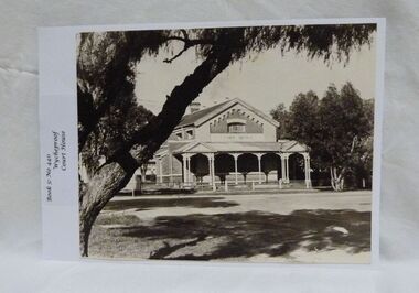
Photograph, Wycheproof Court House, (estimated); mid to late 19th century
... A simple form of Court House built of red-face-brick but embellished by stepped brick work in the principal gable and by the traverse veranda with elaborate frieze and gabled pavilions that protect the street facade. ...A simple form of Court House built of red-face-brick but embellished by stepped brick work in the principal gable and by the traverse veranda with elaborate frieze and gabled pavilions that protect the street facade. ...The Court House opened as a court of petty sessions in 1890 and closed as a court in the early 1980s. It is now a 'Place of Deposit' for paper based products, maps, documents and photographs, and the home of the Wycheproof and District Historical Society Inc. The local Craft Group met at the Court House between 1982 and 2010. The Buloke Shire Council oversees the maintenance of the building.The Court House is No H 1656 on the Victorian Heritage Register. It is the one of only two buildings with this listing in Wycheproof, and characteristic of the type of building constructed in the early days of settlement in Wycheproof. The architecture is of aesthetic value and although some restoration work has taken place to maintain the structure, it remains in good condition and with some of the original furnishings intact.Sepia print of the Wycheproof-Court-House. It was constructed during 1889/90 and commissioned on September 23,1890 as a court-of-petty-sessions. A simple form of Court House built of red-face-brick but embellished by stepped brick work in the principal gable and by the traverse veranda with elaborate frieze and gabled pavilions that protect the street facade. The roof is of slate.Nonecourt house, wycheproof heritage 1890, petty sessions, building, red face brick, gabled pavilions -
 Wycheproof & District Historical Society Inc.
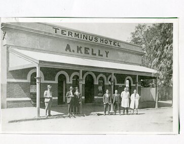
Photograph, Maker Unknown, Terminus Hotel, 1930 (estimated)
... Of brick construction, featuring arch entrance doorways and windows. A verandah protects the street facade. ...Of brick construction, featuring arch entrance doorways and windows. A verandah protects the street facade. ...The Terminus Hotel opened in January 1884, coinciding with the opening of the railway. The hotel had a close connection with the railway, catering for travellers and relieving railway workers. In December 1903 the original wooden structure burnt to the ground. The hotel was rebuilt in 1904 in much the same form see Record No 00306. Mr Andrew Kelly of Nullawil took over the enterprise circa 1930 giving it a new look in the 'Art Deco' style of the period. Mr Kelly and family ran a successful hotel business for forty years.Copy of a B&W photograph of the Terminus Hotel, situated in Broadway Wycheproof circa 1930s. Of brick construction, featuring arch entrance doorways and windows. A verandah protects the street facade. The architecture represents the 'Art Deco' period.Nonehotel wycheproof broadway, men clothing, art deco 1930s -
 Eltham District Historical Society Inc
Photograph, Peter Pidgeon, 820 Main Road, Eltham, 2 Aug. 2022
... During the 1880s under the managment of Hunniford's daughter, Anne, the building was modernised with a new awning and upper facade. In late 1925 a new brick building was erected immediately next door (820 Main Road). ...During the 1880s under the managment of Hunniford's daughter, Anne, the building was modernised with a new awning and upper facade. In late 1925 a new brick building was erected immediately next door (820 Main Road). ...In 1855 the first post office opened in Eltham under the management of Thomas Hunniford. It was a weatherboard building located on the eastern side of Main Road just south of Bridge Street. During the 1880s under the managment of Hunniford's daughter, Anne, the building was modernised with a new awning and upper facade. In late 1925 a new brick building was erected immediately next door (820 Main Road). Following the death of Anne Hunniford in December 1928, J.N Burgoyne was appointed Postmaster. The extension to the right of the store was erected in 1939 for a new telephone exchange adjacent to the store and post office. A continuous telephone service operated by Mr Burgoyne and his family commenced operation 18 November 1939. Approximately 70 extensions were routed through the new exchange, 40 of which were transferred from the Greensborough Exchange. Entry to the exchange was via a separate door on Main Road or via the shop. The public telephone was initially mounted on the wall but later moved to the street. The present store is a barber shop and it remains, though heavily modified, one of only three remaining shop fronts from the early 1900s in Eltham. Comparison photo: SEPP_0700, 00140, SEPP_0701, SEPP_0702 Part of a presentation by Peter Pidgeon to the Society, 13 August 2022 showcasing a series of photographs taken by John Henry Clark over the period 1895 to 1930. John Henry Clark was the youngest of three boys born to William Henry Clark (1823-1877) and Maria White (1843-1914). He and his brothers, William Charles Clark (1872-1945), Clement Kent Clark (1874-1912) operated a photography business (Clark Bros.) from 25 Thomas Street, Windsor near Prahran during the period c.1894 to 1914. Following death of Clement in September 1912 and their mother in 1914, the Clark Bros business appears to have dissolved, the premises demolished, and a new house was under construction in 1915. John set up business independently in 1914 operating out of 29 Moor Street, Fitzroy where he is registered in the 1914 and 1915 Electoral Rolls. By 1916 John had relocated to Eltham where he continued his practice as a photographer and took many of the early images around the district of Little Eltham. Around 1930 John changed professions and opened a small cobbler's shop in 1931 near the pond opposite Dalton Street adjacent to the Jarrold family cottage. He never married and continued his profession as a bootmaker from this little shop, maintaining a close relationship with Mrs Jarrold for the rest of their lives. His bootmaker shop remains today beside the Whitecloud cottage and is one of only three remaining shops in the area from the early 20th century.Comparative photo taken 2022 with one taken from same location over 100 years earlier by noted local photographer J.H. ClarkBorn Digitaleltham, j.h. clark photo (2022), main road, 820 main road, burgoyne store -
 Glen Eira Historical Society
Album - Album page, Rose Craddock, Rose Craddock Avenue, Circa 1972
... facade consisting of a parapeted and recessed central section with hipped slate roof and timber posted verandah with cast iron lace. Projecting pavilions have bayed windows and a secondary wing runs north with angled corners and prominent chimney stack. The front entrance is situated at the north end of the central section and is given emphasis by a small hip roof and false pediment to the verandah. Outbuildings include the timber stables with characteristic hay loft gablet and fretted barges to the south-east. Rear additions in brick ...This photograph is part of the Caulfield Historical Album 1972. This album was created in approximately 1972 as part of a project by the Caulfield Historical Society to assist in identifying buildings worthy of preservation. The album is related to a Survey the Caulfield Historical Society developed in collaboration with the National Trust of Australia (Victoria) and Caulfield City Council to identify historic buildings within the City of Caulfield that warranted the protection of a National Trust Classification. Principal photographer thought to be Trevor Hart, member of Caulfield Historical Society. Most photographs were taken between 1966-1972 with a small number of photographs being older and from unknown sources. All photographs are black and white except where stated, with 386 photographs over 198 pages. From Victorian Heritage Database citation for H0589 Rosecraddock 4-10 Craddock Avenue and 2-8 Keverell CAULFIELD NORTH https://vhd.heritagecouncil.vic.gov.au/places/35279 as at (30/10/2020) "Rosecraddock" is regionally important as a surviving large villa from the early Victorian (1850's) period, offering insight into the lifestyles of the privileged in Caulfield at that time. Its importance is enhanced through its long association with the Langdon family and, in particular, Henry Joseph Langdon, founder of H.J. Langdon and Company, China merchants. Victorian Heritage Database HO16 Rosecraddock, 2-8 Keverell Road & 4-10 Craddock Avenue Caulfield North https://vhd.heritagecouncil.vic.gov.au/places/35279 (as of 17/02/2021) A single storeyed stuccoed villa with west facing facade consisting of a parapeted and recessed central section with hipped slate roof and timber posted verandah with cast iron lace. Projecting pavilions have bayed windows and a secondary wing runs north with angled corners and prominent chimney stack. The front entrance is situated at the north end of the central section and is given emphasis by a small hip roof and false pediment to the verandah. Outbuildings include the timber stables with characteristic hay loft gablet and fretted barges to the south-east. Rear additions in brick and timber are of an early date and utilitarian in character. Also see https://vhd.heritagecouncil.vic.gov.au/places/277 for Significance Statement for the H0589 Victorian Heritage Register listing.Page 174 of Photograph Album with four photographs of Rose Craddock.Handwritten: "Rose Craddock" Rose Craddock Ave. top right] / Neg 197 Nov 1972 [under top left photo] / Neg 209 Nov 1972 [under top right photo] / Neg 196 Nov 1972 [under bottom left photo] / Neg 195 198 Nov 1972 [under bottom right photo] / 174 [bottom right]trevor hart, chimneys, porch, rose craddock, rosecraddock, ringwood, 1850's, henry joseph langdon, h.j. langdon, h.j. langdon and company, china merchants, rosecraddock place, slate roof, return verandah, decorative brackets, keverell road, caulfield north, early victorian style, protruding bay windows, cast iron work, rendered walls, entrances, mansions, craddock avenue -
 Glen Eira Historical Society
Album - Album page, Glenmoore, St George's Road, Circa 1972
... The hipped roof is in slate and has a prominent crean1 brick chimney stack forming part of the facade. Openings are flat arched although the entrance is round arched with a fan light. ...This photograph is part of the Caulfield Historical Album 1972. This album was created in approximately 1972 as part of a project by the Caulfield Historical Society to assist in identifying buildings worthy of preservation. The album is related to a Survey the Caulfield Historical Society developed in collaboration with the National Trust of Australia (Victoria) and Caulfield City Council to identify historic buildings within the City of Caulfield that warranted the protection of a National Trust Classification. Principal photographer thought to be Trevor Hart, member of Caulfield Historical Society. Most photographs were taken between 1966-1972 with a small number of photographs being older and from unknown sources. All photographs are black and white except where stated, with 386 photographs over 198 pages. From Victorian Heritage Database citation for HO59 Glenmoore, 1 St Georges Road Elsternwick https://vhd.heritagecouncil.vic.gov.au/places/35202 as at 30/10/2020 "Glenmoore" is locally significant as a surviving mid nineteenth century villa residence in the then fashionable bi-chromatic brick form. It is also important as the home of Hugh Moore who built several shops in nearby Glen Huntly Road and which remain as important contributors to the architectural character of the Elsternwick Shopping Centre.Victorian Heritage Database citation HO59 Glenmoore, 1 St Georges Road Elsternwick https://vhd.heritagecouncil.vic.gov.au/places/35202 An imposing two storeyed villa in bichrome brick with two storeyed timber posted verandah, coupled with cast iron lace frieze, spandrels and central tympanum enrichment. The hipped roof is in slate and has a prominent crean1 brick chimney stack forming part of the facade. Openings are flat arched although the entrance is round arched with a fan light. The south elevation has bayed windows. Two storeyed hip roofed additions are sympathetic and attached on the north side and at the rear. Inside, the staircase and stained glasswork with initials "HM" and family coat of arms are important surviving elements. INTEGRITY: Good, timber outbuildings of an early date, mature and spacious front garden includes early palm trees. Alterations include reconstruction of facade verandah including tiled pavement and front door on east side. Interior has a high level of integrity. Original grounds included adjoining "Carramar".Page 178 of Photograph Album with three photographs of Glenmoore, St Georges Road. Handwritten: "Glenmoore" 1 St George's Road [top right] / 178 [bottom right]trevor hart, chimneys, porch, mansion, slate roof, return verandah, stained glass, cast iron frieze, glenmoore, 1860's, hugh moore, glenmoore estate, double storey, elsternwick shops, st george's road, thomas watts, elsternwick, victorian style, protruding bay windows, cast iron work, bi-chromatic bricks, gardens, balconies, moore's buildings, glen huntly road, stairs, house names -
 Glen Eira Historical Society
Album - Album page, Old Fire Station, 4 Selwyn Street, Circa 1972
... brick and stone...asymmetrical facade...[Criterion D] trevor hart rendered 1890's melbourne metropolitan fire brigade mfb fire-fighting jj webster timber merchants esquire motors car repair australian broadcasting corporation abc selwyn street brick and stone asymmetrical facade anglo-dutch gable rusticated and smooth-faced limestone elsternwick fire station elsternwick fire station JJ Webster Pty Ltd Motor vehicle repair shops stone horseshoe arch entrance Handwritten: old fire station 4 Selwyn Street [top right] / 188 [bottom right] Page 188 of Photograph Album with two photographs of the old Elsternwick Fire Station. ...This album was created in approximately 1972 as part of a project by the Caulfield Historical Society to assist in identifying buildings worthy of preservation. The album is related to a Survey the Caulfield Historical Society developed in collaboration with the National Trust of Australia (Victoria) and Caulfield City Council to identify historic buildings within the City of Caulfield that warranted the protection of a National Trust Classification. Principal photographer thought to be Trevor Hart, member of Caulfield Historical Society. Most photographs were taken between 1966-1972 with a small number of photographs being older and from unknown sources. All photographs are black and white except where stated, with 386 photographs over 198 pages. From Victorian Heritage Database citation for H2376 Former Elsternwick Fire Station, 2-4 Selwyn Street Elsternwick - Victorian Heritage Register https://vhd.heritagecouncil.vic.gov.au/places/2645 (as at 21/11/2021) The Former Elsternwick Fire Station was built and commenced operation in 1896. It was one of 32 new fire stations built between 1892 and 1896 by the newly formed Melbourne Metropolitan Fire Brigade ('MFB') to form a comprehensive fire-fighting network across Melbourne. The MFB was established in 1891 as Victoria's government-run fire-fighting service in Melbourne and its growing suburbs. By 1918 motorised fire engine appliances had replaced horse-drawn fire vehicles across the metropolitan area, and the consequently larger areas that fire stations could protect meant the 1896 Elsternwick Fire Station was one of many which was becoming obsolete. The MFB continued to use the Elsternwick Fire Station up until the Station's closure in 1926. From 1927 the former Fire Station was leased by neighbouring timber merchants JJ Webster Pty Ltd who subsequently purchased the property from the MFB in 1934. From 1954 the 'Esquire Motors' car repair business traded at the site, and changes to the former Fire Station building including the complete enclosure of its yard by corrugated steel walls and roofing appear to have been completed in the mid-1950s. In 1990 the Australian Broadcasting Corporation ('ABC') purchased the former Fire Station together with five other adjoining land parcels in Selwyn Street. From that time until 2017 the former Elsternwick Fire Station has been used by the ABC as office and storage space in its Selwyn Street television studio complex.From Victorian Heritage Database citation for H2376 Former Elsternwick Fire Station, 2-4 Selwyn Street Elsternwick - Victorian Heritage Register https://vhd.heritagecouncil.vic.gov.au/places/2645 (as at 21/11/2021) The Former Elsternwick Fire Station is historically significant as one of the 10 remaining fire stations of the original 32 built for the newly established Melbourne Metropolitan Fire Brigade ('MFB') during the four-year period 1892 to 1896. These fire stations were constructed following the establishment in 1891 of the MFB, Victoria's government-run fire-fighting service for metropolitan Melbourne and its growing suburban population. These new stations formed a crucial part of the MFB's fire-fighting network across Melbourne. The Former Elsternwick Fire Station clearly demonstrates the historical development of fire-fighting services in Melbourne, especially the expansion of the newly-formed MFB throughout Melbourne's suburbs during the 1890s. [Criterion A] The Former Elsternwick Fire Station is architecturally significant as a fine example of a late nineteenth century fire station. Constructed shortly after the establishment of the MFB, it displays characteristics of its class of place that remain mostly unchanged from the former Station's historically important period of development and use. A particularly strong element of the Former Elsternwick Fire Station is the large and strikingly-detailed stone horseshoe arch, designed for horse-drawn fire-fighting vehicles, at the street entrance to its fire-engine room. [Criterion D]Page 188 of Photograph Album with two photographs of the old Elsternwick Fire Station.Handwritten: old fire station 4 Selwyn Street [top right] / 188 [bottom right]trevor hart, rendered, 1890's, melbourne metropolitan fire brigade, mfb, fire-fighting, jj webster, timber merchants, esquire motors, car repair, australian broadcasting corporation, abc, selwyn street, brick and stone, asymmetrical facade, anglo-dutch gable, rusticated and smooth-faced limestone, elsternwick fire station, elsternwick, fire station, jj webster pty ltd, motor vehicle repair shops, stone horseshoe arch entrance -
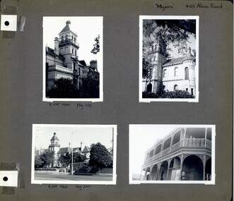 Glen Eira Historical Society
Album - Album page, Myoora, 405 Alma Road, Circa 1972
... facade enjoyed an outlook to port phillip from a two-storey cast iron verandah. Bay windows, chimneys, the tower and the turret and minor details are brought together in a sophisticated asymmetrical composition. This is reflected in the planning. The asymmetry of Myoora pivoting on the tower is the most notable feature of the building. The walls are built of cement rendered brick ...This photograph is part of the Caulfield Historical Album 1972. This album was created in approximately 1972 as part of a project by the Caulfield Historical Society to assist in identifying buildings worthy of preservation. The album is related to a Survey the Caulfield Historical Society developed in collaboration with the National Trust of Australia (Victoria) and Caulfield City Council to identify historic buildings within the City of Caulfield that warranted the protection of a National Trust Classification. Principal photographer thought to be Trevor Hart, member of Caulfield Historical Society. Most photographs were taken between 1966-1972 with a small number of photographs being older and from unknown sources. All photographs are black and white except where stated, with 386 photographs over 198 pages. Myoora - Victorian Heritage Register (VHR) Number H0490 https://vhd.heritagecouncil.vic.gov.au/places/275 Myoora, 405 Alma Road, North Caulfield, was designed by Reed, Henderson & Smart and can be attributed to Anketell Henderson. It was built in 1886 and 1887 for Thomas Christian, who had founded the fabled gold mine, the Day Dawn at Charters Towers. He never occupied the house although his widow lived there for some time. The house was subdivided into three and later six flats. Myoora was one of many large mansions on broad acres with gardens in Caulfield. Perhaps the grandest was Labassa. The mansions date from the 1850s through to the late 1890s. The siting of Myoora on a ridge influenced its planning and composition. A central hall and corridor along the ridge is entered from the centre of the more formal north facade. The entrance is marked by an elaborately detailed tower. A stair turret provides a second accent. The western end of the building is completed by a massively detailed chimney as the service wing. The south facade enjoyed an outlook to port phillip from a two-storey cast iron verandah. Bay windows, chimneys, the tower and the turret and minor details are brought together in a sophisticated asymmetrical composition. This is reflected in the planning. The asymmetry of Myoora pivoting on the tower is the most notable feature of the building. The walls are built of cement rendered brick. The cement render has not been painted. The roof is slate. The balconies and verandah are cast iron. The footings and cellar are bluestone. The architectural firm Reed, Henderson & Smart was very prominent in Victoria in the nineteenth century. Anketell Henderson was an eminent and well respected member of the profession. He worked successfully in London and interstate as well as in Victoria. They were better known for commercial and public buildings. Myoora is an important private commission. The style of Myoora is a combination of details from the Continental and English Renaissance through the boom style and the Queen Anne style. There is also an early influence from the American Romanesque style especially in the stair turret. The latter style was important at the turn of the century and Myoora is a significant precursor. Other buildings of a similar scale survive in Caulfield and elsewhere. Labassa, the most fabulous, is quite different stylistically as are most of the other comparable mansions.Page 6 of Photograph Album including four black and white photographs of the mansion Myoora. Two photographs in the top half of the page are in portrait orientation while the two photographs in the bottom half of the page are in landscape orientation.Handwritten: "Myoora" 405 Alma Rd [top right hand corner] / 8 Oct 1966 Neg 229 [underneath top left photograph] / 8 Oct 1966 Neg 230 [underneath bottom left photograph] / 6 [bottom right]caulfield north, trevor hart, alma road, mansion, myoora, tower, lacework, arched windows, anketell henderson, thomas christian, 1880's, cement rendered brick, slate roof, cast iron verandah, cast iron balconies, bluestone footings, queen anne, american romanesque, bay windows, boom style, continental and english renaissance, cast iron work, reed henderson & smart, flats, gardens, asymmetrical style