Showing 26 items matching "burke road -- kew east (vic.)"
-
 Kew Historical Society Inc
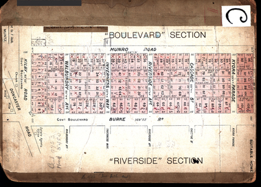
Plan - Subdivision Plan, Boulevard Estate - Boulevard Section, 1930-1936
... east kew...boulevard estate...Munro Road -- Kew East (Vic.)...Kilby Road -- Kew East (Vic.)...Burke...Road, Kew. The Plans in the collection are rarely in pristine form, being working plans on which the agent would write notes and record lots sold and the prices of these. The subdivision plans are historically significant examples of the growth of urban Melbourne from the beginning of the 20th Century up until the 1980s. A number of the plans are double-sided and often include a photograph on the reverse. subdivision plans - east kew boulevard estate Munro Road -- Kew East (Vic.) Kilby Road -- Kew East (Vic.) Burke ...Pru Sanderson, in her groundbreaking ‘City of Kew Urban Conservation Study : Volume 2 - Development History’ (1988), summarised the periods of urban development and subdivisions of land in Kew. The periods that she identified included 1845-1880, 1880-1893, 1893-1921, 1921-1933, 1933-1943, and Post-War Development. These periods were selected as they represented periods of rapid growth or decline in urban development. An obvious starting point for Sanderson’s groupings involved population growth and the associated economic cycles. These cycles also highlighted urban expansion onto land that was predominantly rural, although in other cases it represented the decline and breakup of large estates. A number of the plans in the Kew Historical Society’s collection can also be found in other collections, such as those of the State Library of Victoria and the Boroondara Library Service. A number are however unique to the collection.The Kew Historical Society collection includes almost 100 subdivision plans pertaining to suburbs of the City of Melbourne. Most of these are of Kew, Kew East or Studley Park, although a smaller number are plans of Camberwell, Deepdene, Balwyn and Hawthorn. It is believed that the majority of the plans were gifted to the Society by persons connected with the real estate firm - J. R. Mathers and McMillan, 136 Cotham Road, Kew. The Plans in the collection are rarely in pristine form, being working plans on which the agent would write notes and record lots sold and the prices of these. The subdivision plans are historically significant examples of the growth of urban Melbourne from the beginning of the 20th Century up until the 1980s. A number of the plans are double-sided and often include a photograph on the reverse. This plan shows a subdivision with two sections: the ‘Boulevard Section’ and the ‘Riverside Section’. The first of these sections bordered Burke Road between Kilby Road and the farm beside the Yarra. Kilby Road, Munro Road, Burke Road and Old Burke Road bordered the 102 lots in the Boulevard Section of the plan. The streets within the Section included Walbundry Avenue, Inverness Way, Riverside Avenue, Cascade Street and Kyora Parade. These street names, at least in this subdivision plan linked the two Sections of the subdivision. At a later date, the City of Kew decided to alter the street names. Walbundry, Inverness, Riverside, Cascade and Kyora were all renamed as ‘Drives’ (e.g. Kyora Drive). The subdivision plan is of interest in that it names High Street in Kew as Doncaster Road. It also shows the location of the wooden church that was later removed to Yarraville on the corner of Kilby Road and High Street. The plan predates later developments such as the S. E. Dickens Supermarket.subdivision plans - east kew, boulevard estate, munro road -- kew east (vic.), kilby road -- kew east (vic.), burke road -- kew east (vic.), walbundry avenue -- kew east (vic.), inverness way -- kew east (vic.), riverside avenue -- kew east (vic.), cascade drive -- kew east (vic.), nyora parade -- kew east (vic.) -
 Kew Historical Society Inc
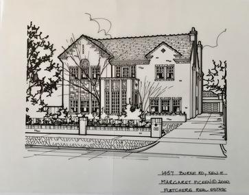
Drawing - Property Illustration, Margaret Picken, 1457 Burke Road, Kew East, 2000
... kew (vic.)...property illustrations — buildings — kew east (vic.)...1457 burke road...Kew melbourne This drawing is one of a series created by Margaret Picken for real estate agents in Melbourne between 1983 and 2006. Each work is signed and dated by the artist. The drawings in the Picken Collection are invaluable assets for identifying architectural features and styles. The year in which the work was created is also a valuable record for house historians, as a number of the properties depicted have either been altered since that date or demolished. artist -- margaret picken 1950- property illustrations — buildings — kew (vic.) property illustrations — buildings — kew east (vic.) 1457 burke road -- kew east (vic.) 1467 BURKE RD., KEWE. / MARGARET PICKEN (c) 2000 / FLETCHERS REAL ESTATE 'Hastings' was built in the English Revival style in 1930. ...After training as a Cartographic Draftsman within the mining industry, I worked as a property illustrator for real estate firms in the eastern suburbs of Melbourne for 23 years from 1983. I initially photographed houses with a Polaroid camera and made a 'thumbnail' sketch while there. The photos were used to scale off a sketch in pencil and then that sketch was overlaid with drafting film and the 'pen and ink' completed. The pens I used were the Rotring ‘Rapidigraph’ drafting pens. The ink was also made by Rotring (German).The film was ‘Rapidraw’, polyester drafting film, double matte. It takes a very fine line and doesn’t bleed. As well as house sketches, there were often floor plans and site plans ordered. Aerial sketches were ordered when the property needed an overall view. (Margaret Picken, 2020)This drawing is one of a series created by Margaret Picken for real estate agents in Melbourne between 1983 and 2006. Each work is signed and dated by the artist.Gift of Margaret Picken, 2020'Hastings' was built in the English Revival style in 1930. The pen and ink drawing on drafting film was created by Margaret Picken in 2000.1467 BURKE RD., KEWE. / MARGARET PICKEN (c) 2000 / FLETCHERS REAL ESTATEartist -- margaret picken 1950-, property illustrations — buildings — kew (vic.), property illustrations — buildings — kew east (vic.), 1457 burke road -- kew east (vic.) -
 Kew Historical Society Inc
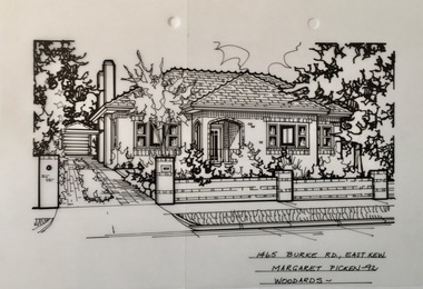
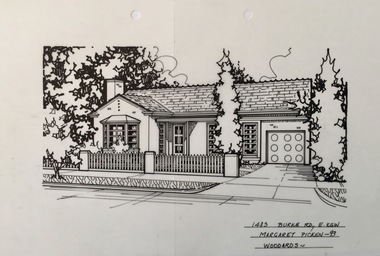
Drawing - Property Illustration, Margaret Picken, 1465 Burke Road, Kew East, 1992
... property illustrations — buildings — kew east (vic.)...1465 burke road...The year in which the work was created is also a valuable record for house historians, as a number of the properties depicted have either been altered since that date or demolished. artist -- margaret picken 1950- property illustrations — buildings — kew east (vic.) 1465 burke road - kew east (vic) 1465 BURKE RD., EAST KEW / MARGARET PICKEN ~92 / WOODARDS ~ Pen and ink drawing on drafting film of 1465 Burke Road, Kew East by Margaret Picken. 1465 Burke Road, Kew East Drawing Property Illustration Margaret Picken Woodards ...After training as a Cartographic Draftsman within the mining industry, I worked as a property illustrator for real estate firms in the eastern suburbs of Melbourne for 23 years from 1983. I initially photographed houses with a Polaroid camera and made a 'thumbnail' sketch while there. The photos were used to scale off a sketch in pencil and then that sketch was overlaid with drafting film and the 'pen and ink' completed. The pens I used were the Rotring ‘Rapidigraph’ drafting pens. The ink was also made by Rotring (German).The film was ‘Rapidraw’, polyester drafting film, double matte. It takes a very fine line and doesn’t bleed. As well as house sketches, there were often floor plans and site plans ordered. Aerial sketches were ordered when the property needed an overall view. (Margaret Picken, 2020)This drawing is one of a series created by Margaret Picken for real estate agents in Melbourne between 1983 and 2006. Each work is signed and dated by the artist.Gift of Margaret Picken, 2020Pen and ink drawing on drafting film of 1465 Burke Road, Kew East by Margaret Picken.1465 BURKE RD., EAST KEW / MARGARET PICKEN ~92 / WOODARDS ~ artist -- margaret picken 1950-, property illustrations — buildings — kew east (vic.), 1465 burke road - kew east (vic) -
 Kew Historical Society Inc
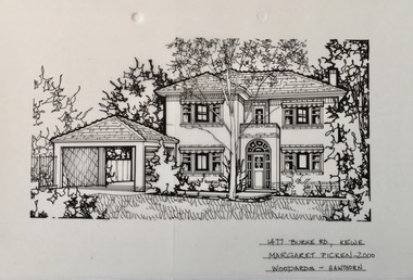
Drawing - Property Illustration, Margaret Picken, 1477 Burke Road, Kew East, 2000
... property illustrations — buildings — kew east (vic.)...1477 burke road...The year in which the work was created is also a valuable record for house historians, as a number of the properties depicted have either been altered since that date or demolished. artist -- margaret picken 1950- property illustrations — buildings — kew east (vic.) 1477 burke road - kew east (vic) 1477 BURKE ST., KEW E. / MARGARET PICKEN ~2000 / WOODARDS ~ HAWTHORN Pen and ink drawing on drafting film of 1477 Burke Road, Kew East by Margaret Picken. 1477 Burke Road, Kew East Drawing Property Illustration Margaret Picken Woodards (Hawthorn) ...After training as a Cartographic Draftsman within the mining industry, I worked as a property illustrator for real estate firms in the eastern suburbs of Melbourne for 23 years from 1983. I initially photographed houses with a Polaroid camera and made a 'thumbnail' sketch while there. The photos were used to scale off a sketch in pencil and then that sketch was overlaid with drafting film and the 'pen and ink' completed. The pens I used were the Rotring ‘Rapidigraph’ drafting pens. The ink was also made by Rotring (German).The film was ‘Rapidraw’, polyester drafting film, double matte. It takes a very fine line and doesn’t bleed. As well as house sketches, there were often floor plans and site plans ordered. Aerial sketches were ordered when the property needed an overall view. (Margaret Picken, 2020)This drawing is one of a series created by Margaret Picken for real estate agents in Melbourne between 1983 and 2006. Each work is signed and dated by the artist.Gift of Margaret Picken, 2020Pen and ink drawing on drafting film of 1477 Burke Road, Kew East by Margaret Picken.1477 BURKE ST., KEW E. / MARGARET PICKEN ~2000 / WOODARDS ~ HAWTHORNartist -- margaret picken 1950-, property illustrations — buildings — kew east (vic.), 1477 burke road - kew east (vic) -
 Kew Historical Society Inc
Drawing - Property Illustration, Margaret Picken, 1483 Burke Road, Kew East, 1993
... property illustrations — buildings — kew east (vic.)...1483 burke road...The year in which the work was created is also a valuable record for house historians, as a number of the properties depicted have either been altered since that date or demolished. artist -- margaret picken 1950- property illustrations — buildings — kew east (vic.) 1483 burke road - kew east (vic) 1483 BURKE RD., E. ...After training as a Cartographic Draftsman within the mining industry, I worked as a property illustrator for real estate firms in the eastern suburbs of Melbourne for 23 years from 1983. I initially photographed houses with a Polaroid camera and made a 'thumbnail' sketch while there. The photos were used to scale off a sketch in pencil and then that sketch was overlaid with drafting film and the 'pen and ink' completed. The pens I used were the Rotring ‘Rapidigraph’ drafting pens. The ink was also made by Rotring (German).The film was ‘Rapidraw’, polyester drafting film, double matte. It takes a very fine line and doesn’t bleed. As well as house sketches, there were often floor plans and site plans ordered. Aerial sketches were ordered when the property needed an overall view. (Margaret Picken, 2020)This drawing is one of a series created by Margaret Picken for real estate agents in Melbourne between 1983 and 2006. Each work is signed and dated by the artist.Gift of Margaret Picken, 2020Pen and ink drawing on drafting film of 1483 Burke Road, Kew East by Margaret Picken.1483 BURKE RD., E. KEW / MARGARET PICKEN ~93 / WOODARDS ~ artist -- margaret picken 1950-, property illustrations — buildings — kew east (vic.), 1483 burke road - kew east (vic) -
 Kew Historical Society Inc
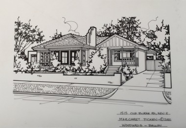
Drawing - Property Illustration, Margaret Picken, 1515 Old Burke Road, Kew East, 2000
... kew east (vic.)...1515 old burke road - kew east (vic)...The year in which the work was created is also a valuable record for house historians, as a number of the properties depicted have either been altered since that date or demolished. artist -- margaret picken 1950- property illustrations — buildings — kew east (vic.) 1515 old burke road - kew east (vic) 1515 OLD BURKE RD., KEW E. / MARGARET PICKEN ©2000 / WOODARDS ~ BALWYN Pen and ink drawing on drafting film of 1515 Old Burke Road, Kew East by Margaret Picken. 1515 Old Burke Road, Kew East Drawing Property Illustration Margaret Picken Woodards (Balwyn) ...After training as a Cartographic Draftsman within the mining industry, I worked as a property illustrator for real estate firms in the eastern suburbs of Melbourne for 23 years from 1983. I initially photographed houses with a Polaroid camera and made a 'thumbnail' sketch while there. The photos were used to scale off a sketch in pencil and then that sketch was overlaid with drafting film and the 'pen and ink' completed. The pens I used were the Rotring ‘Rapidigraph’ drafting pens. The ink was also made by Rotring (German).The film was ‘Rapidraw’, polyester drafting film, double matte. It takes a very fine line and doesn’t bleed. As well as house sketches, there were often floor plans and site plans ordered. Aerial sketches were ordered when the property needed an overall view. (Margaret Picken, 2020)This drawing is one of a series created by Margaret Picken for real estate agents in Melbourne between 1983 and 2006. Each work is signed and dated by the artist.Gift of Margaret Picken, 2020Pen and ink drawing on drafting film of 1515 Old Burke Road, Kew East by Margaret Picken.1515 OLD BURKE RD., KEW E. / MARGARET PICKEN ©2000 / WOODARDS ~ BALWYNartist -- margaret picken 1950-, property illustrations — buildings — kew east (vic.), 1515 old burke road - kew east (vic) -
 Kew Historical Society Inc
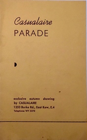
Programme, Casualaire Parade, Undated
... Road) were major locations in suburban Melbourne in the postwar period for civic and private events including theatre productions and exhibitions. The Arthur Dear Collection (in conjunction with the scrapbooks compiled by Marion Tilley) provide a comprehensive snapshot of performing arts in Kew during the 1940s, 1950s and 1960s. The collection includes valuable data about performances, performers, directors etc., during this period. fashion - kew, casualaire, gwynne harrison, valerie jacobson, lyle sampson, joan heathfield, mary rose campbell, marie johnson Arthur Dear Collection Kew Recreation Hall -- Wellington Street -- Kew (Vic.) Programme for an exclusive Autumn showing by Casualaire, 1353 Burke Road, East ...The Kew Recreation Hall (1880-1960 was a major venue for civic events, exhibitions, theatre, concerts and in this case a commercial fashion parade.Arthur Henry Dear was an employee of the City of Kew, acting as Hall Keeper of the Kew Recreation Hall in Wellington Street, and later the new Kew City Hall in Cotham Road. The Arthur Dear Collection contains memorabilia - tickets, programmes, invitations - as well as his identification badge. Items in the collection dates from the 1940s to the 1970s. The Kew Recreation Hall (Wellington Street) and later the Kew City Hall (Cotham Road) were major locations in suburban Melbourne in the postwar period for civic and private events including theatre productions and exhibitions. The Arthur Dear Collection (in conjunction with the scrapbooks compiled by Marion Tilley) provide a comprehensive snapshot of performing arts in Kew during the 1940s, 1950s and 1960s. The collection includes valuable data about performances, performers, directors etc., during this period. Programme for an exclusive Autumn showing by Casualaire, 1353 Burke Road, East Kew, compered by Gwynne Harrisonfashion - kew, casualaire, gwynne harrison, valerie jacobson, lyle sampson, joan heathfield, mary rose campbell, marie johnson, arthur dear collection, kew recreation hall -- wellington street -- kew (vic.) -
 Kew Historical Society Inc
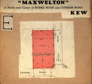
Plan - Subdivision Plan, Maxwelton, Kew, 1920-1940
... Barnes. subdivision plans - kew Mazwelton subdivision Burke Road -- Kew (Vic.) Cotham Road -- Kew (Vic.) The subdivision, ‘Maxwelton’, included four lots in East Kew, at the northwest corner of Burke Road and Cotham Road. ...Pru Sanderson, in her groundbreaking ‘City of Kew Urban Conservation Study : Volume 2 - Development History’ (1988), summarised the periods of urban development and subdivisions of land in Kew. The periods that she identified included 1845-1880, 1880-1893, 1893-1921, 1921-1933, 1933-1943, and Post-War Development. These periods were selected as they represented periods of rapid growth or decline in urban development. An obvious starting point for Sanderson’s groupings involved population growth and the associated economic cycles. These cycles also highlighted urban expansion onto land that was predominantly rural, although in other cases it represented the decline and breakup of large estates. A number of the plans in the Kew Historical Society’s collection can also be found in other collections, such as those of the State Library of Victoria and the Boroondara Library Service. A number are however unique to the collection.The Kew Historical Society collection includes almost 100 subdivision plans pertaining to suburbs of the City of Melbourne. Most of these are of Kew, Kew East or Studley Park, although a smaller number are plans of Camberwell, Deepdene, Balwyn and Hawthorn. It is believed that the majority of the plans were gifted to the Society by persons connected with the real estate firm - J. R. Mathers and McMillan, 136 Cotham Road, Kew. The Plans in the collection are rarely in pristine form, being working plans on which the agent would write notes and record lots sold and the prices of these. The subdivision plans are historically significant examples of the growth of urban Melbourne from the beginning of the 20th Century up until the 1980s. A number of the plans are double-sided and often include a photograph on the reverse. A number of the latter are by noted photographers such as J.E. Barnes.The subdivision, ‘Maxwelton’, included four lots in East Kew, at the northwest corner of Burke Road and Cotham Road. Lot 3 is identified as the location of an existing house. The site of the subdivision equates to that parcel of land where a contemporary block of three storey apartments at 1245 Burke Road is now located.subdivision plans - kew, mazwelton subdivision, burke road -- kew (vic.), cotham road -- kew (vic.) -
 Kew Historical Society Inc
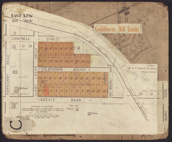
Plan - Subdivision Plan, Goldthorns Hill Estate, 1925
... Kew East (Vic.) Lady Loch Drive -- Kew East (Vic.) Argyle Road -- Kew East (Vic.) Lady Brassey Drive -- Kew East (Vic.) Campbell Street -- Kew East (Vic.) Goldthorns -- Kew (Vic.) Subdivisions -- Kew East (Viv.) Goldthorns Hill Estate The Goldthorns Hill Estate subdivision was first put up for auction in 1925. The subdivision took its name from the mansion ‘Goldthorns’, shown on the plan between Normanby Road and Lady Loch’s Drive. Contemporary advertisements describe forty-three home sites being fro sale, yet only forty-one appear on this plan. Buyers were lured by the prospect of the proposed extension of the Burke ...Pru Sanderson, in her groundbreaking ‘City of Kew Urban Conservation Study : Volume 2 - Development History’ (1988), summarised the periods of urban development and subdivisions of land in Kew. The periods that she identified included 1845-1880, 1880-1893, 1893-1921, 1921-1933, 1933-1943, and Post-War Development. These periods were selected as they represented periods of rapid growth or decline in urban development. An obvious starting point for Sanderson’s groupings involved population growth and the associated economic cycles. These cycles also highlighted urban expansion onto land that was predominantly rural, although in other cases it represented the decline and breakup of large estates. A number of the plans in the Kew Historical Society’s collection can also be found in other collections, such as those of the State Library of Victoria and the Boroondara Library Service. A number are however unique to the collection.The Kew Historical Society collection includes almost 100 subdivision plans pertaining to suburbs of the City of Melbourne. Most of these are of Kew, Kew East or Studley Park, although a smaller number are plans of Camberwell, Deepdene, Balwyn and Hawthorn. It is believed that the majority of the plans were gifted to the Society by persons connected with the real estate firm - J. R. Mathers and McMillan, 136 Cotham Road, Kew. The Plans in the collection are rarely in pristine form, being working plans on which the agent would write notes and record lots sold and the prices of these. The subdivision plans are historically significant examples of the growth of urban Melbourne from the beginning of the 20th Century up until the 1980s. A number of the plans are double-sided and often include a photograph on the reverse. The Goldthorns Hill Estate subdivision was first put up for auction in 1925. The subdivision took its name from the mansion ‘Goldthorns’, shown on the plan between Normanby Road and Lady Loch’s Drive. Contemporary advertisements describe forty-three home sites being fro sale, yet only forty-one appear on this plan. Buyers were lured by the prospect of the proposed extension of the Burke Road tram to High Street. Discerning buyers were advised that only one house could be built per allotment, and that houses needed to be constructed of brick, stone or concrete and have a slate or tiled roof.goldthorns avenue -- kew east (vic.), lady loch drive -- kew east (vic.), argyle road -- kew east (vic.), lady brassey drive -- kew east (vic.), campbell street -- kew east (vic.), goldthorns -- kew (vic.), subdivisions -- kew east (viv.), goldthorns hill estate -
 Kew Historical Society Inc
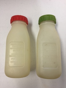
Container - Model Dairy Plastic Milk Bottles, Model Dairy, c.1960
... Burke Road in the east. In addition to these dairy producers, there were also a number of accredited dairy retailers in the suburb. The largest and most enduring of these was the Model Dairy founded by the Kew pioneer James Venn Morgan. Milk bottles that include the name of the producer or retailer are historically significant as they represent a period in Kew's history before the mass production of milk in the second half of the Twentieth Century. A number of these named bottles have the additional attribute of rarity. dairies - kew model dairy - cotham road - kew (vic ...This pair of milk bottles, produced for the Model Dairy in Cotham Road, Kew, were donated by Vik Sabaliauskas. They belonged to his father who worked at Model Dairy in the 1950s and 1960s. Vik wrote about his father: "As for my father, his whole life story is interesting. He was part of the big immigration program after WW2. He was a displaced person in Germany like lots of others who came out looking for a new life. Our family name is actually SABALIAUSKAS which is of Lithuanian descent. My Dad was also named Vik (Viktoras). He was known as Big Vik and I was little Vik. He arrived in Australia in 1947 and then did his 2 years of work organised by the Government and then he came to Melbourne. We lived in Tyler St Preston and he rode his pushbike to and from Kew every working day for years. In my estimation that was about 13 kms for about 6 or 7 years. Imagine that happening today. Freezing Winter mornings and hot Summer afternoons. His English was poor but he had a great work ethic like all European immigrants. His duties related to maintaining and operating all the machines. One story that he told me about was that after I was born (in 1959) he made friends with one of the drivers who delivered milk to the dairy. He asked him to get a container of milk from the farmer everyday which was just for me. I remember going to the Model Dairy Family Christmas parties which were always well patronised. I also remember visiting him in the PANCH Hospital (Bell Street Preston) where he was treated for kidney stones caused by drinking very creamy milk. He wasn't happy when he was told by the doctor to cut back on milk. My Dad was one month short of his 95th birthday when he died and he lived a pretty healthy life." (2019)Kew was a major milk producing district in the Nineteenth and early Twentieth centuries, with three major dairy farms lining the Yarra between Studley Park in the west and Burke Road in the east. In addition to these dairy producers, there were also a number of accredited dairy retailers in the suburb. The largest and most enduring of these was the Model Dairy founded by the Kew pioneer James Venn Morgan. Milk bottles that include the name of the producer or retailer are historically significant as they represent a period in Kew's history before the mass production of milk in the second half of the Twentieth Century. A number of these named bottles have the additional attribute of rarity.Pair of plastic milk bottles, designated on the front as to be used in the refigerator on on picnics. One bottle has a red screw on lid and the other a green lid. The bottles are semi-transparent. [The record also includes a photograph of Vic Sabaliauskas, provided by his son. The photograph dates from the period when he was employed at the Model Dairy].Impressed on the front of both bottles: "Unbreakable picnic and refrigerator bottle made expressly for Model Dairy Pty Ltd Cotham Rd Kew"dairies - kew, model dairy - cotham road - kew (vic) -
 Kew Historical Society Inc
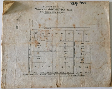
Plan - Subdivision Plan, J Hurrey, Section 115 in the Parish of Boroondara Near Richmond Bridge, 1853
... Kew. This subdivision plan is the earliest original map or plan in the collection which shows parts of what is now the City of Boroondara, dating from circa 1853. It provides important information for researchers on subsequent subdivisions following the original land sales in [Camberwell] Boroondara. The site, on the east side of Burke Road is a highly-significant and historic site. This is believed to be the only extant copy of the subdivision in public collections. parish of boroondara, subdivision plans - camberwell, section 115 - boroondara subdivision plans -- camberwell (vic ...Despite the plans claims that it is a subdivision near the Richmond Bridge, Section 115 was located at what is now Camberwell Junction. While the plan only lists government roads rather than named streets, the section was located on the east side of Burke Road, stretching up the hill from the current Junction. Research on Trove, conducted by Kerry Fairbank, discovered an advertisement for unsold lots in Section 115 which clarifies the extent and location of subsequent land sales in the original section. The original article can be viewed through the link in the catalogue record. The interesting link to Kew is the reference to James Beavan as the purchaser of lots 14 and 15. The historian Gwen McWilliam has notes that a Mr Beavan changed his name from Bevan. The Bevans were descendants of the Derricks family of Kew. This subdivision plan is the earliest original map or plan in the collection which shows parts of what is now the City of Boroondara, dating from circa 1853. It provides important information for researchers on subsequent subdivisions following the original land sales in [Camberwell] Boroondara. The site, on the east side of Burke Road is a highly-significant and historic site. This is believed to be the only extant copy of the subdivision in public collections.A small plan on parchment listing 28 lots, between one and two acres each, for sale in Section 115 in the Parish of Boroondara, dating from 1853 when the portion was subdivided.Obverse: Lot 16 "Joseph Duval", Lots 14 & 15 "James Beavan". Other annotations (measurements) are unreadable. Reverse: "KH-981 / Section 115 in the Parish of Boroondara / Near Richmond Bridge / 1640T. / J Duval / 14-15 J. Beavanparish of boroondara, subdivision plans - camberwell, section 115 - boroondara, subdivision plans -- camberwell (vic), riverscape road, burke road, camberwell junction -
 Kew Historical Society Inc
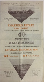
Plan - Subdivision Plan, Charteris Estate, East Ivanhoe, 1939
... Kew melbourne The Charteris Estate in Ivanhoe was sold in a number of sections. Copies of a subdivision plan of the first section is in the State Library of Victoria collection. This later section of the Charteris Estate includes lots in the Government Boulevard, Castella Street, McArthur Road, Burke Road North, Charteris Drive and Warncliff Road. Subdivision plans like that for the Charteris Estate are invaluable records for local historians identifying when lots in streets were promoted for sale. charteris estate - east ivanhoe (vic ...The Charteris Estate in Ivanhoe was sold in a number of sections. Copies of a subdivision plan of the first section is in the State Library of Victoria collection. This later section of the Charteris Estate includes lots in the Government Boulevard, Castella Street, McArthur Road, Burke Road North, Charteris Drive and Warncliff Road.Subdivision plans like that for the Charteris Estate are invaluable records for local historians identifying when lots in streets were promoted for sale.Four-fold brochure advertising the Charteris Estate in East Ivanhoe in 1939. Streets named on the plan include: the Government Boulevard, Castella Street, McArthur Road, Burke Road North, Charteris Drive and Warncliff Road. The brochure contains photos of Charterisville, the home of F De Castella Esq and also of attractive rolling hills. Annotations in pencilcharteris estate - east ivanhoe (vic), subdivision plans - east ivanhoe (vic) -
 Kew Historical Society Inc
Drawing - Property Illustration, Margaret Picken, 1317 Burke Road, Kew, 1992
... Kew melbourne This drawing is one of a series created by Margaret Picken for real estate agents in Melbourne between 1983 and 2006. Each work is signed and dated by the artist. The drawings in the Picken Collection are invaluable assets for identifying architectural features and styles. The year in which the work was created is also a valuable record for house historians, as a number of the properties depicted have either been altered since that date or demolished. artist -- margaret picken 1950- property illustrations — buildings — kew (vic.) 1317 burke road - kew (vic) 1317 BURKE RD., KEW EAST / MARGARET PICKEN ~92 / WOODARDS ~ KEW Pen and ink drawing on drafting film of 1317 Burke Road, Kew by Margaret Picken. 1317 Burke Road, Kew Drawing Property Illustration Margaret Picken Woodards (Kew) ...After training as a Cartographic Draftsman within the mining industry, I worked as a property illustrator for real estate firms in the eastern suburbs of Melbourne for 23 years from 1983. I initially photographed houses with a Polaroid camera and made a 'thumbnail' sketch while there. The photos were used to scale off a sketch in pencil and then that sketch was overlaid with drafting film and the 'pen and ink' completed. The pens I used were the Rotring ‘Rapidigraph’ drafting pens. The ink was also made by Rotring (German).The film was ‘Rapidraw’, polyester drafting film, double matte. It takes a very fine line and doesn’t bleed. As well as house sketches, there were often floor plans and site plans ordered. Aerial sketches were ordered when the property needed an overall view. (Margaret Picken, 2020)This drawing is one of a series created by Margaret Picken for real estate agents in Melbourne between 1983 and 2006. Each work is signed and dated by the artist.Gift of Margaret Picken, 2020Pen and ink drawing on drafting film of 1317 Burke Road, Kew by Margaret Picken.1317 BURKE RD., KEW EAST / MARGARET PICKEN ~92 / WOODARDS ~ KEWartist -- margaret picken 1950-, property illustrations — buildings — kew (vic.), 1317 burke road - kew (vic) -
 Kew Historical Society Inc
Plan - Subdivisional Sale of 11 Villa Sites, East Kew, 1939
... Kew, a number of other plans and advertisements have been donated by individuals, of which this is an example. Subdivision plans -- Kew (Vic.) Enfield Street -- Kew (Vic.) Burke Road -- Kew (Vic.) Single page residential subdivision plan advertising house lots for sale, in what was then designated as East ...Subdivision plans and real estate flyers/brochures reveal a number of aspects of urban development and history. The Kew Historical Society's collection of these plans, as well as advertisements extracted from magazines, cover key aspects of community development and architectural history of Kew and Kew Eat as well as surrounding suburbs. While most of the plans in the collection were gifted to the Society by the former City of Kew, a number of other plans and advertisements have been donated by individuals, of which this is an example.Single page residential subdivision plan advertising house lots for sale, in what was then designated as East Kew but is now Kew, in the following streets: Burke Road, Enfield Street. The flyer includes a smaller locality plan at right. Information on the flyer indicates that the land was previously owned by the Melbourne & Metropolitan Tramways Board.subdivision plans -- kew (vic.), enfield street -- kew (vic.), burke road -- kew (vic.) -
Kew Historical Society Inc
Plan - Charteris Estate, Ivanhoe [East], 1927
... Kew, a number of other plans and advertisements have been donated by individuals, of which this is an example. charteris estate - east ivanhoe (vic) subdivision plans -- Ivanhoe east (Vic.) D.C. McArthur Charterisville Original 4-page bifold handout advertising 43 residential lots for sale in the Charteris Estate subdivision in Ivanhoe [now classified as Ivanhoe East]. This brochure was created to sell the third section of the estate which it labels as 'The Most Superb Section'. Streets within the subdivision include: Burke Road ...Subdivision plans and real estate flyers/brochures reveal a number of aspects of urban development and history. The Kew Historical Society's collection of these plans, as well as advertisements extracted from magazines, cover key aspects of community development and architectural history of Kew and Kew Eat as well as surrounding suburbs. While most of the plans in the collection were gifted to the Society by the former City of Kew, a number of other plans and advertisements have been donated by individuals, of which this is an example.Original 4-page bifold handout advertising 43 residential lots for sale in the Charteris Estate subdivision in Ivanhoe [now classified as Ivanhoe East]. This brochure was created to sell the third section of the estate which it labels as 'The Most Superb Section'. Streets within the subdivision include: Burke Road North, McArthur Road, Castella Street, and the Government Boulevard. In addition to the overall plan spread across pages 2 and 3, each page includes a number of interesting photographs including: a number of the new Burke Road Bridge, a sports ground, Hoyts Picture Theatre in Ivanhoe, a croquet ground, and Ivanhoe shopping centre [named Motor Cross Junction].charteris estate - east ivanhoe (vic), subdivision plans -- ivanhoe east (vic.), d.c. mcarthur, charterisville -
Kew Historical Society Inc
Plan - Burke Road Junction Estate, East Kew, 1940
... Subdivisions -- Kew East (Vic.)...Burke Road...Subdivisions -- Kew East (Vic.) Burke Road Junction Estate Original 4-page bifold brochure advertising the Burke Road Junction Estate in Kew East. ...Subdivision plans and real estate flyers/brochures reveal a number of aspects of urban development and history. The Kew Historical Society's collection of these plans, as well as advertisements extracted from magazines, cover key aspects of community development and architectural history of Kew and Kew Eat as well as surrounding suburbs. While most of the plans in the collection were gifted to the Society by the former City of Kew, a number of other plans and advertisements have been donated by individuals, of which this is an example.Original 4-page bifold brochure advertising the Burke Road Junction Estate in Kew East. Advertised for sale in 1940, the estate comprised 16 'Central Allotments' fronting High Street, Kilby Road, and Glass Street. Pages 1 & 4, the front and back covers, includes a panoramic photograph of the junction which features a number of shops still extant, but also with buildings long demolished and redeveloped. These include the petrol station and the dairy on the southeast and southwest corners of Burke Road and High Street/Doncaster Road. The dairy includes a statue of a cow on its roof. Pages 2 & 3 include a detailed plan of the estate. subdivisions -- kew east (vic.), burke road junction estate -
 Kew Historical Society Inc
Photograph - High Street looking north to Burke Road, 1907-08
... Kew Historical Society Inc Kew Court House 188 High Street Kew melbourne While a number of subdivisions of what was to become Kew East occurred in the 1880s, such as the 'Mount Pleasant Estate' (1888) and 'Monterey Estate' (1888), Glynn's Lot 91 remained open farmland until the Harp Estate (1912) was sold, hence the undeveloped nature of the view in 1907-8. A rare image of the open farmland in the eastern part of Kew looking towards Burke Road in 1907-8. Harp of Erin High Street -- East Kew (Vic ...While a number of subdivisions of what was to become Kew East occurred in the 1880s, such as the 'Mount Pleasant Estate' (1888) and 'Monterey Estate' (1888), Glynn's Lot 91 remained open farmland until the Harp Estate (1912) was sold, hence the undeveloped nature of the view in 1907-8.A rare image of the open farmland in the eastern part of Kew looking towards Burke Road in 1907-8.Damaged, and very rare, black & white photograph of what was to become the suburb of East Kew, taken by a member of the Bennett family in 1907-8. The photograph is taken from the Harp of Erin Hotel showing, apart from a building on the left (no longer extant), fenced open farmland stretching into the far distance.HIGH ST LOOKING NOTRTH TO BURKE RD FROM HARP / EDWD GLYNN'S LOT 91 FROM 1851 / GIFT FROM BENNETT FAMILY 22 HARP RD EAST KEW 1980 / 1907-8harp of erin, high street -- east kew (vic), harp estate -
 Kew Historical Society Inc
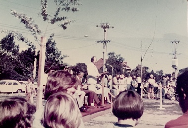
Photograph - Civic event in Stradbroke Park, 1976
... Kew Conservation Study) stradbroke park cr alan hutchinson team sports -- kew (vic.) Colour photographic positive (with colour degradation) of sporting teams at a civic event in Stradbroke Park in Kew East in May 1976. The event was officiated by the Mayor of Kew, Cr Alan Hutchinson. Sporting teams in uniform included: footballers, athletes, cricketers, hockey players. Stradbroke Park is situated on the western boundary of Kew at Burke and Harp Roads ...Stradbroke Park. Extent: Kilby Road to Harp Road at Burke Road. Historical Documentation: 1851 - Portion 91 purchased by Edward Glynn; 1888 - The Harp of Erin Estate (which included Section 91) offered for sale; 1896 - The area now known as Stradbroke Park was bisected by a creek that flowed from the Yarra via Hay's Paddock (q.v.) and extended through to Burke Road; 1943 - W.D. Birrell, Town Clerk of Kew, proposed that the creek be filled and a reserve created; 1954 - Entire area designated as 'open space' and named 'Stradbroke Park'. The line of the creek that ran through the Park created a further reserve on the north side of High Street, now known as 'Harrison Reserve'. Existing Condition: The park is largely of mown grass that has mature trees set into it It is possible that a number of these are remnant of the original vegetation, while there are also a number of exotic trees introduced, particularly at the northern end of the park. The southern end is dominated by playing fields. (Source: Sanderson, P 1988. Kew Conservation Study)Colour photographic positive (with colour degradation) of sporting teams at a civic event in Stradbroke Park in Kew East in May 1976. The event was officiated by the Mayor of Kew, Cr Alan Hutchinson. Sporting teams in uniform included: footballers, athletes, cricketers, hockey players. Stradbroke Park is situated on the western boundary of Kew at Burke and Harp Roads.stradbroke park, cr alan hutchinson, team sports -- kew (vic.) -
 Kew Historical Society Inc
Photograph - Civic event in Stradbroke Park, 1976
... Kew Conservation Study) stradbroke park cr alan hutchinson team sports -- kew (vic.) Colour photographic positive (with colour degradation) of sporting teams at a civic event in Stradbroke Park in Kew East in May 1976. The event was officiated by the Mayor of Kew, Cr Alan Hutchinson. Stradbroke Park is situated on the western boundary of Kew and bordered by Burke and Harp Roads ...Stradbroke Park. Extent: Kilby Road to Harp Road at Burke Road. Historical Documentation: 1851 - Portion 91 purchased by Edward Glynn; 1888 - The Harp of Erin Estate (which included Section 91) offered for sale; 1896 - The area now known as Stradbroke Park was bisected by a creek that flowed from the Yarra via Hay's Paddock (q.v.) and extended through to Burke Road; 1943 - W.D. Birrell, Town Clerk of Kew, proposed that the creek be filled and a reserve created; 1954 - Entire area designated as 'open space' and named 'Stradbroke Park'. The line of the creek that ran through the Park created a further reserve on the north side of High Street, now known as 'Harrison Reserve'. Existing Condition: The park is largely of mown grass that has mature trees set into it It is possible that a number of these are remnant of the original vegetation, while there are also a number of exotic trees introduced, particularly at the northern end of the park. The southern end is dominated by playing fields. (Source: Sanderson, P 1988. Kew Conservation Study)Colour photographic positive (with colour degradation) of sporting teams at a civic event in Stradbroke Park in Kew East in May 1976. The event was officiated by the Mayor of Kew, Cr Alan Hutchinson. Stradbroke Park is situated on the western boundary of Kew and bordered by Burke and Harp Roads.stradbroke park, cr alan hutchinson, team sports -- kew (vic.) -
 Kew Historical Society Inc
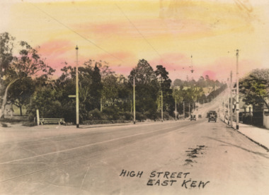
Postcard - High Street, East Kew, c.1927
... road is in Kew, although the narrow section on the right hand side of the photo is now Kew East. High Street progresses through a number of significant road junctions: beginning at Barkers Road; progressing through the intersection of Studley Park Road, Denmark Street and Princess Street at Kew Junction; branching left at the junction with Cotham Road; before reaching the junction with Valerie Street and Harp Road. It reaches its end at the junction of Burke Road, Kilby Road, Bulleen Road and High Street itself. An early photograph of this iconic Memorial that locates it in its context. high street -- kew (vic ...High Street, Kew is the main Road in Kew. It was once also known as Bulleen Road, or Main Street. This section of the road is in Kew, although the narrow section on the right hand side of the photo is now Kew East. High Street progresses through a number of significant road junctions: beginning at Barkers Road; progressing through the intersection of Studley Park Road, Denmark Street and Princess Street at Kew Junction; branching left at the junction with Cotham Road; before reaching the junction with Valerie Street and Harp Road. It reaches its end at the junction of Burke Road, Kilby Road, Bulleen Road and High Street itself. An early photograph of this iconic Memorial that locates it in its context. Small, colorised real photo postcard of High Street, East Kew. Electric light poles line the road. Victoria Park is on the left and further on the horizon is the Boroondara General Cemetery.high street -- kew (vic.), victoria park, tram lines -- kew (vic.) -
 Kew Historical Society Inc
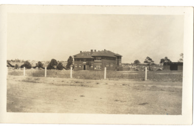
Postcard - Kew East State School No.3161, 35 Kitchener Street, c.1927
... The Kew East and Mont Albert Heritage Gap Study (August 2020) established that: 'Kew East Primary School No. 3136 is historically significant for the evidence it provides of an early phase in the development of Kew East which gathered momentum from the 1920s, as housing developed rapidly and the population increased in response to the extension of the High Street tram to Harp Road then Burke Road then improved tram connections between the area and the city.' A rare and early photograph of the school taken four years after its construction. schools -- Kew East (vic ...What is now Kew East Primary School was opened on its current site in Kitchener Street in 1923. The Kew East and Mont Albert Heritage Gap Study (August 2020) established that: 'Kew East Primary School No. 3136 is historically significant for the evidence it provides of an early phase in the development of Kew East which gathered momentum from the 1920s, as housing developed rapidly and the population increased in response to the extension of the High Street tram to Harp Road then Burke Road then improved tram connections between the area and the city.'A rare and early photograph of the school taken four years after its construction. Small, sepia coloured photographic positive of East Kew State School. The two storey red brick building was opened in 1923. This view, three years after its construction shows preliminary fencing and undeveloped playing grounds.schools -- kew east (vic.), government schools -- kew -- kew east, strathalbyn street -
 Kew Historical Society Inc
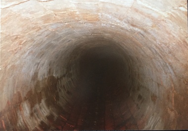
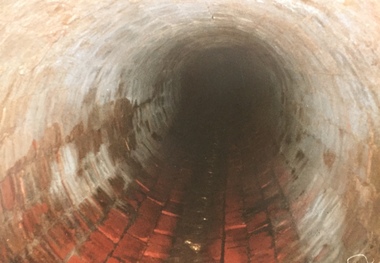
Photograph - Kew Main Drain, 1984
... Burke Road at Kew High School before discharging into the Yarra River. The fourth drain, Kew Main Drain connects directly with the Yarra River to the West of Glass Creek.' The Kew Main Drain is a barrel drain that was created in the 1930s, and follows the route of the former Connor's Creek from the vicinity of Genazzano FCJ College to the Yarra River in East Kew Important and verifiable evidence of the construction methods used by the Melbourne & Metropolitan Board of Works in building the Kew Main Drain, before its reconstruction in c.1985. kew main drain stormwater drains -- kew (vic.) connor's creek -- kew (vic.) ...'Kew, Kew East, Balwyn & Balwyn North are located approximately 7km north east of Melbourne. Four main stormwater drains service the area flowing from south to north. Three of the drains: Deepdene Drain; Balwyn Drain & Glass Creek converge in Kew East just west of Burke Road at Kew High School before discharging into the Yarra River. The fourth drain, Kew Main Drain connects directly with the Yarra River to the West of Glass Creek.' The Kew Main Drain is a barrel drain that was created in the 1930s, and follows the route of the former Connor's Creek from the vicinity of Genazzano FCJ College to the Yarra River in East KewImportant and verifiable evidence of the construction methods used by the Melbourne & Metropolitan Board of Works in building the Kew Main Drain, before its reconstruction in c.1985.Original print colour positive photograph of the Kew Main Drain, provided on 14/12.84 to the Chief Engineer of the City of Kew, Ian Poulter, by the Supervising Engineer (Works), Southern and Eastern Drainage, Melbourne & Metropolitan Board of Works. The record includes an image of the reverse as well as the donation document from the MMBW."A84/1855-9 / 750mm council drain looking D/S [down stream] and across Parkhill Road. To be replaced with 1200 mm R.C.P. [reinforced concrete pipe] as part of MMBW Kew Main Drain reconstruction works"kew main drain, stormwater drains -- kew (vic.), connor's creek -- kew (vic.) -
 Kew Historical Society Inc
Photograph - Kew Main Drain, 1984
... Burke Road at Kew High School before discharging into the Yarra River. The fourth drain, Kew Main Drain connects directly with the Yarra River to the West of Glass Creek.' The Kew Main Drain is a barrel drain that was created in the 1930s, and follows the route of the former Connor's Creek from the vicinity of Genazzano FCJ College to the Yarra River in East Kew Important and verifiable evidence of the construction methods used by the Melbourne & Metropolitan Board of Works in building the Kew Main Drain, before its reconstruction in c.1985. kew main drain stormwater drains -- kew (vic.) connor's creek -- kew (vic.) ...'Kew, Kew East, Balwyn & Balwyn North are located approximately 7km north east of Melbourne. Four main stormwater drains service the area flowing from south to north. Three of the drains: Deepdene Drain; Balwyn Drain & Glass Creek converge in Kew East just west of Burke Road at Kew High School before discharging into the Yarra River. The fourth drain, Kew Main Drain connects directly with the Yarra River to the West of Glass Creek.' The Kew Main Drain is a barrel drain that was created in the 1930s, and follows the route of the former Connor's Creek from the vicinity of Genazzano FCJ College to the Yarra River in East KewImportant and verifiable evidence of the construction methods used by the Melbourne & Metropolitan Board of Works in building the Kew Main Drain, before its reconstruction in c.1985.Original print colour positive photograph of the Kew Main Drain, provided on 14/12.84 to the Chief Engineer of the City of Kew, Ian Poulter, by the Supervising Engineer (Works), Southern and Eastern Drainage, Melbourne & Metropolitan Board of Works. The record includes an image of the reverse as well as the donation document from the MMBW."A84/1855-10 / 750mm council drain looking U/S [up stream] from Parkhill Road, Kew."kew main drain, stormwater drains -- kew (vic.), connor's creek -- kew (vic.) -
 Melbourne Tram Museum
Photograph - High St Kew - Harp of Erin - PMTT, Les Poole, 1916
... East Kew terminus just northeast of Strathalbyn Street and Harp Road. The Harp of Erin Hotel fence and tree are on the right. There are few other buildings in the view. The Kew Cemetery line was extended along High Street to Strathalbyn Street, Kew on 8/5/1915. There is a tramway shelter on the left-hand side of the road. This photo is not taken at Burke Road. Yields information about the High Street Kew tram line c1916. Trams tramways Kew High St Kew PMTT Shelters Harp of Erin Has the stamp of the ARHS Vic ...Photograph shows a PMTT four-wheel Californian combination tram at the High Street East Kew terminus just northeast of Strathalbyn Street and Harp Road. The Harp of Erin Hotel fence and tree are on the right. There are few other buildings in the view. The Kew Cemetery line was extended along High Street to Strathalbyn Street, Kew on 8/5/1915. There is a tramway shelter on the left-hand side of the road. This photo is not taken at Burke Road. Yields information about the High Street Kew tram line c1916.Black and white photograph with a stamp and details on the rear.Has the stamp of the ARHS Vic Div L G Poole Collection and in ink "Harp of Erin 1916 - Hotel Burke Rd."trams, tramways, kew, high st kew, pmtt, shelters, harp of erin