Showing 84 items matching "central business district"
-
 Melbourne Tram Museum
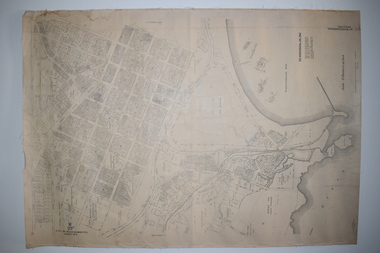
Document - Report, Graeme Breydon, "Future Development of Tramways in the Melbourne Central Business District", Apr. 1973
... "Future Development of Tramways in the Melbourne Central Business District"...Six paged duplicated paper or report titled "Future Development of Tramways in the Melbourne Central Business District", by Graeme Breydon, presented to the AETA 1973 Convention, based on an article prepared for the August 1972 issue of Electric Traction. ...Refers to a paper delivered by D Lees, MMTB Planning Engineer, Swanston St underground proposal, "Future Development of Tramways in the Melbourne Central Business District" Document Report Graeme Breydon ...Six paged duplicated paper or report titled "Future Development of Tramways in the Melbourne Central Business District", by Graeme Breydon, presented to the AETA 1973 Convention, based on an article prepared for the August 1972 issue of Electric Traction. Has references, looks at proposals for underground part of the Swanston St tramway, alternatives for flinders St and a Yarra crossing, St Kilda Road issues, William St, CBD problems and travel issues, shortcomings of proposals, alternatives, Flinders Gate interchanges, associated track improvements, cost benefit ratios, comments and conclusions. 2nd copy contains within a brown manila quarto sized folded marked "Tramways in the Melbourne. Central Business District" G. Breydon (Aug. 1972). See also Reg Item 3069 and 2812 for further references. .2 - letter - c Jan 1973 - carbon copy of a Letter to the Editor for response to a letter in Electric Traction Dec. 1972 responding to H. Moses and making specific comments. .3 - letter - 29/1/1973 to Graeme Breydon from the Ian Cooper of the AETA responding and accepting an offer of Graeme to present on the Board's plan for the forthcoming AETA Canberra Conference in April 1972. .4 - Report - 17 Quarto pages, stapled on the left hand side titled "Future Development of Melbourne Tramway System, with particular reference to possible improvements to the fixed plant of the Central Business District", written by Graeme Breydon, dated Jan. 1972. Refers to the 1962 report of Risson, and scheme presented to Council, Has hand drawn maps of the central area of Melbourne, Looks at the background, traffic issues, proposed underground loop, employment distribution, an extension to Elisabeth St, reversing loops, St Kilda Road and comments on the MMTB proposals. Refers to a paper delivered by D Lees, MMTB Planning Engineer, Swanston St underground proposal,on outside of the 2nd copy, and on top right hand corner of paper AETA Library mark "4E11"trams, tramways, mmtb, melbourne, traffic control, swanston st, st kilda rd, elizabeth st, bourke st, aeta, transportation, underground tramways -
 Federation University Historical Collection
Map - Ephemera, Melbourne City Tourist Shuttle, c2006
... A brochure with a map of the Melbourne Central Business District....Barker Library (top floor) Mount Helen goldfields John So was Mayor of Melbourne from 2001-2008 Melbourne Southbank Melbourne Docks Fitzroy Carlton East Melbourne John So A brochure with a map of the Melbourne Central Business District. Melbourne City Tourist Shuttle Map Ephemera ...John So was Mayor of Melbourne from 2001-2008A brochure with a map of the Melbourne Central Business District.melbourne, southbank, melbourne docks, fitzroy, carlton, east melbourne, john so -
 Ballarat Heritage Services
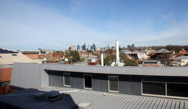
Digital photographs, L.J. Gervasoni, Looking Towards Melbourne City and inner north from Fitzroy High School, 2013
... Colour photograph looking towards the Melbourne Central Business District....Ballarat Heritage Services PO Box 2209 Bakery Hill Post Office goldfields melbourne viewscape cbd inner north cityscape Colour photograph looking towards the Melbourne Central Business District. Looking Towards Melbourne City and inner north from Fitzroy High School Digital photographs L.J. ...Colour photograph looking towards the Melbourne Central Business District.melbourne, viewscape, cbd, inner north, cityscape -
 Ballarat Heritage Services
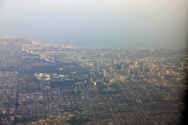
Photograph - Digital Photograph, L.J. Gervasoni, Melbourne CBD and Albert Park Lake on approach Melbourne Airport, 2016
... Digital Image showing an aerial view of the Melbourne Central Business District and Albert Park....Ballarat Heritage Services PO Box 2209 Bakery Hill Post Office goldfields aerial melbourne yarra river cbd albert park lake port phillip bay Digital Image showing an aerial view of the Melbourne Central Business District and Albert Park. Melbourne CBD and Albert Park Lake on approach Melbourne Airport Photograph Digital Photograph L.J. ...Digital Image showing an aerial view of the Melbourne Central Business District and Albert Park.aerial, melbourne, yarra river, cbd, albert park, lake, port phillip bay -
 Ballarat Heritage Services
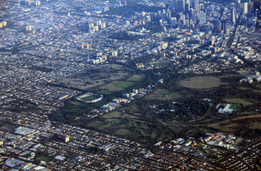
Digital Photograph, L.J. Gervasoni, Royal Park CBD and zoo from the air, 2016
... Digital Image showing an aerial view of the Melbourne Central Business District and Royal Park....Ballarat Heritage Services PO Box 2209 Bakery Hill Post Office goldfields aerial melbourne yarra river cbd royal park zoo Digital Image showing an aerial view of the Melbourne Central Business District and Royal Park. Royal Park CBD and zoo from the air Digital Photograph L.J. ...Digital Image showing an aerial view of the Melbourne Central Business District and Royal Park.aerial, melbourne, yarra river, cbd, royal park, zoo -
 Ballarat Heritage Services
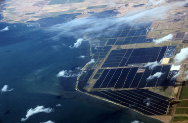
Digital Photograph, L.J. Gervasoni, werribee farm from the air, 2016
... Digital Image showing an aerial view of the Melbourne Central Business District and Royal Park....Ballarat Heritage Services PO Box 2209 Bakery Hill Post Office goldfields aerial melbourne Werribee Farm sewerage Digital Image showing an aerial view of the Melbourne Central Business District and Royal Park. werribee farm from the air Digital Photograph L.J. ...Digital Image showing an aerial view of the Melbourne Central Business District and Royal Park.aerial, melbourne, werribee farm, sewerage -
Federation University Historical Collection
Poster, University of Ballarat Camp Street Campus, 2000, 2000
... "In acknowledgement of the joint agreement to redevelop historic camp Street as a dynamic arts precinct utilising the central business district area of Ballarat."...The Camp Street Campus was later known as the Arts Academy. arts academy camp street precinct camp street arts precinct "In acknowledgement of the joint agreement to redevelop historic camp Street as a dynamic arts precinct utilising the central business district area of Ballarat." Framed poster of a collage of images showing plans for the University of Ballarat Camp Street Campus, later known as the Arts Academy. ...The University of Ballarat became Federation University Australia in 2014. The Camp Street Campus was later known as the Arts Academy. Framed poster of a collage of images showing plans for the University of Ballarat Camp Street Campus, later known as the Arts Academy. "In acknowledgement of the joint agreement to redevelop historic camp Street as a dynamic arts precinct utilising the central business district area of Ballarat."arts academy, camp street precinct, camp street, arts precinct -
Box Hill Historical Society
Book, Henshall Hansen Associates, Planners and Economists,Green and Dale Associates, Urban Designers and Landscape Architects, Box Hill District Centre Structure Plan - June 1991, 1991
... Central Business District...Box Hill Historical Society Box Hill Heritage Centre Suite 7 Town Hall Hub Box Hill melbourne Two copies on shelf. Central Business District Land use Car Parks Transport Town planning Landscape Planning Box Hill Central This paper provides ideas for the plans for the Box Hill District Centre for the next decade. ...This paper provides ideas for the plans for the Box Hill District Centre for the next decade. During the 1980s the Box Hill District Centre underwent substantial development. A new retail complex (Box Hill Central) combined with a transport interchange (rail/bus services) and a pedestrian mall added greater choice for the shopper as well as convenience and improved access.292pThis paper provides ideas for the plans for the Box Hill District Centre for the next decade. During the 1980s the Box Hill District Centre underwent substantial development. A new retail complex (Box Hill Central) combined with a transport interchange (rail/bus services) and a pedestrian mall added greater choice for the shopper as well as convenience and improved access.central business district, land use, car parks, transport, town planning, landscape planning, box hill central -
Box Hill Historical Society
Book, Henshall Hansen Associates, Box Hill District Centre Structure Plan Report 2 : Planning Options for the 1990's, 1/09/1990
... Central Business District...Box Hill Historical Society Box Hill Heritage Centre Suite 7 Town Hall Hub Box Hill melbourne Central Business District Land use Town planning Transport Landscape Planning Box Hill Central This paper examines four options addressing the future character, role and form of the Box Hill District Centre. ...This paper examines four options addressing the future character, role and form of the Box Hill District Centre. Each option looks at possible future land use and development within specific areas.114pThis paper examines four options addressing the future character, role and form of the Box Hill District Centre. Each option looks at possible future land use and development within specific areas.central business district, land use, town planning, transport, landscape planning, box hill central -
 City of Ballarat Libraries
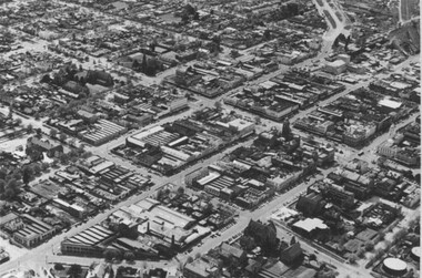
Photograph, Aerial View of the Ballarat CBD in 1957 / 1958
... ...Central Business District...Aerial view Sturt Street Ballarat Central Business District CBD Aerial View of the Ballarat CBD in 1957 / 1958. ...This aerial view of the Ballarat CBC was taken sometime in 1957 or 1958. Sturt Street can be seen running from the right centre to top left.aerial view, sturt street, ballarat, central business district, cbd -
Box Hill Historical Society
Book, Zenith Development Corporation, Box Hill District Centre : a structural plan proposal, 1/12/1990 12:00:00 AM
... ...Central Business District...Box Hill Zenith Development Corporation Town planning Central Business District A submission made as a contribution to the Box Hill Structure Plan and, in particular, to the exhibition of the "Options for the 1990's" publication, by Box Hill City Council. 43p. ...A submission made as a contribution to the Box Hill Structure Plan and, in particular, to the exhibition of the "Options for the 1990's" publication, by Box Hill City Council.43p.A submission made as a contribution to the Box Hill Structure Plan and, in particular, to the exhibition of the "Options for the 1990's" publication, by Box Hill City Council.box hill, zenith development corporation, town planning, central business district -
 Bendigo Historical Society Inc.
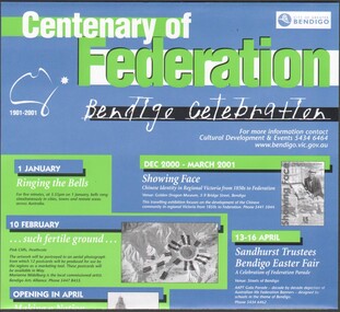
Flyer - Centenary of Federation 1901 - 2001, CoGB
... Centenary of Federation 1901 - 2001 Heritage Architecture Walk Central Business District of Bendigo. Six-fold purple printed flyer prepared by the National Trust Bendigo....History House 11 Mackenzie Street Bendigo goldfields City of Bendigo Centenary of Federation Centenary of Federation 1901 - 2001 Heritage Architecture Walk Central Business District of Bendigo. Six-fold purple printed flyer prepared by the National Trust Bendigo. ...Centenary of Federation 1901 - 2001 Heritage Architecture Walk Central Business District of Bendigo. Six-fold purple printed flyer prepared by the National Trust Bendigo.city of bendigo, centenary of federation -
 Warrnambool and District Historical Society Inc.
Documents, Late 20th, early 21st centuries
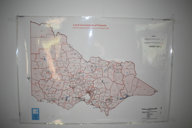
... These ten documents (maps, plans, photographs) mostly come from the Warrnambool City Council and most contain information on sub-divisions and titles of properties in areas around the Central Business District of Warrnambool. The dates range from 1986 to 2006. ...It has black printing on buff-coloured paper. .4 This is a plan of the allotments in part of the Central Business District of Warrnambool. It is printed in black and white. .5 This is a 2006 coloured aerial photograph of the harbour at Warrnambool – Breakwater etc. .6 This is a 2006 coloured aerial photograph of the Lake Pertobe area in Warrnambool .7 This is a coloured aerial photograph of Warrnambool’s streets over-stamped with road numbers in large blockings. .8 This is a plan showing the title details of Section 11 in Warrnambool. ...Warrnambool and District Historical Society Inc. 2 Gilles Street (south of Merri St) Warrnambool great-ocean-road These ten documents (maps, plans, photographs) mostly come from the Warrnambool City Council and most contain information on sub-divisions and titles of properties in areas around the Central Business District of Warrnambool. The dates range from 1986 to 2006. ...These ten documents (maps, plans, photographs) mostly come from the Warrnambool City Council and most contain information on sub-divisions and titles of properties in areas around the Central Business District of Warrnambool. The dates range from 1986 to 2006. These maps, plans and photographs are of some interest as they give historical details of subdivisions in Warrnambool and date from the late 20th century. .1 This is a laminated map of the boundaries of Local Governments in Victoria. It is Sheet I of 2 and has red and blue pencil markings and black boundary markings. .2 This is a copy of a plan of a survey in black and white markings on paper. .3 This is a plan of the title details of Section 19 Warrnambool. It has black printing on buff-coloured paper. .4 This is a plan of the allotments in part of the Central Business District of Warrnambool. It is printed in black and white. .5 This is a 2006 coloured aerial photograph of the harbour at Warrnambool – Breakwater etc. .6 This is a 2006 coloured aerial photograph of the Lake Pertobe area in Warrnambool .7 This is a coloured aerial photograph of Warrnambool’s streets over-stamped with road numbers in large blockings. .8 This is a plan showing the title details of Section 11 in Warrnambool. It has black printing on buff-coloured paper. .9.1 This is a plan of sub-divisions in parts of Crown Allotments 38 & 39 in Warrnambool. It has green, pink and yellow markings with black printing. .9.2 This is a plan of the sub-divisions in parts of Allotments 38 & 39 in Warrnambool. It has pink, yellow and blue markings with black printing. It is somewhat faded. warrnambool c.b.d. maps and plans, history of warrnambool -
 Bendigo Historical Society Inc.
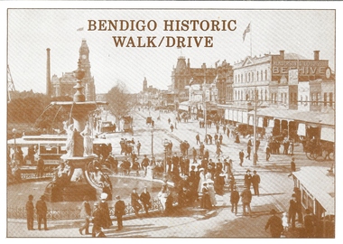
Document - BASIL MILLER COLLECTION: BENDIGO HISTORIC WALK/DRIVE, 1988
... Details central business district historic buildings, (Shamrock Hotel, Post Office, etc). ...Details central business district historic buildings, (Shamrock Hotel, Post Office, etc). ...Tourist brochure titled, 'Bendigo Historic Walk/Drive, Bendigo and District Tourism Association. Details central business district historic buildings, (Shamrock Hotel, Post Office, etc). List of attractions on rear page.Crown Castleton Publishers, 6 Schumakers Lane, Maiden Gully, Victoria, 3551.person, individual, basil miller -
 Ararat & District Historical Society (operating the Langi Morgala Museum)
Photograph
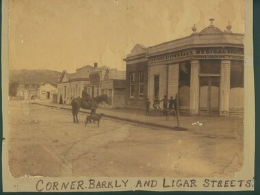
... An early streetscape of Ararat's central business district....Ararat & District Historical Society (operating the Langi Morgala Museum) 48 Queen Street Ararat grampians An early streetscape of Ararat's central business district. Written on front" Corner of Barkly and Ligar Streets Sepia photograph of a shop on a corner. ...An early streetscape of Ararat's central business district.Sepia photograph of a shop on a corner. Written on the shop front is View Point Dispensary Medical Dispensary. Five young boys and a dog are standing in front of the shop while a man is seated on a horse beside a dog.Written on front" Corner of Barkly and Ligar Streets -
 Ballarat Heritage Services
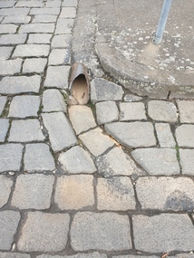
Photograph - Digital photograph, Bluestone gutter and Drain, Lydiard Street South, Ballarat, 2020, 15/02/2020
... Bluestone gutters are a feature of the Ballarat Central Business District....Ballarat Heritage Services PO Box 2209 Bakery Hill Post Office goldfields Bluestone gutters are a feature of the Ballarat Central Business District. bluestone gutter drain lydiard street south Colour photograph of a bluestone drain on the corner of Lydiard Street South and Chancery Lane. ...Bluestone gutters are a feature of the Ballarat Central Business District.Colour photograph of a bluestone drain on the corner of Lydiard Street South and Chancery Lane. bluestone, gutter, drain, lydiard street south -
 Greensborough Historical Society
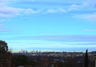
Photograph - Digital image, Marilyn Smith, Melbourne City skyline from Greensborough, 16/08/2015
... Greensborough is approximately 23 kilometres from the Melbourne Central Business District. This photo of the Melbourne skyline was taken from Greensborough....Greensborough Historical Society 34A Glenauburn Road Lower Plenty Lower Plenty melbourne Greensborough is approximately 23 kilometres from the Melbourne Central Business District. This photo of the Melbourne skyline was taken from Greensborough. greensborough melbourne Digital copy of colour photograph Melbourne City skyline from Greensborough Photograph - Digital image Marilyn Smith ...Greensborough is approximately 23 kilometres from the Melbourne Central Business District. This photo of the Melbourne skyline was taken from Greensborough.Digital copy of colour photographgreensborough, melbourne -
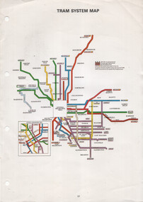 Melbourne Tram Museum
Map, The Met, "Tram System Map", c1990
... Tram system map published by The Met to show the various Melbourne tram routes, route numbers, principal road names, suburbs and tram routes within the Central Business District....Melbourne Tram Museum 8 Wallen Road Hawthorn melbourne Tram system map published by The Met to show the various Melbourne tram routes, route numbers, principal road names, suburbs and tram routes within the Central Business District. Provides information about Melbourne tram routes c1990 tramways Melbourne The Met map tram routes routes Printed A4 full colour sheet with four punch holes on left hand side. ...Tram system map published by The Met to show the various Melbourne tram routes, route numbers, principal road names, suburbs and tram routes within the Central Business District.Provides information about Melbourne tram routes c1990Printed A4 full colour sheet with four punch holes on left hand side.tramways, melbourne, the met, map, tram routes, routes -
 Bendigo Historical Society Inc.
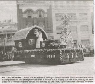
Newspaper - JENNY FOLEY COLLECTION: HISTORIC FESTIVAL
... historic festival: crowds line the streets of Bendigo's central business district to watch the annual procession. ...History House 11 Mackenzie Street Bendigo goldfields NEWSPAPER Bendigo advertiser the way we were Bendigo Advertiser "The way we were" from Monday, January 31, 2005. historic festival: crowds line the streets of Bendigo's central business district to watch the annual procession. ...Bendigo Advertiser "The way we were" from Monday, January 31, 2005. historic festival: crowds line the streets of Bendigo's central business district to watch the annual procession. This photograph was taken in the late 1940s or early 1950s. The truck, used by the State Electricity Commission for the parade, was donated by Eric Finch, a general carrier and wood merchant. The clip is in a folder.newspaper, bendigo advertiser, the way we were -
 Ballarat Tramway Museum
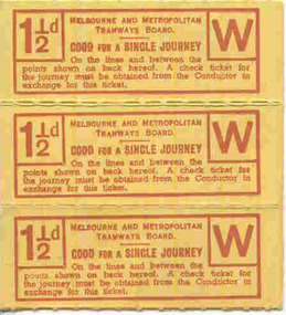
Ephemera - Ticket/s, Melbourne and Metropolitan Tramways Board (MMTB), MMTB 1 1/2d pre-purchased tickets, 1930's?
... Eight tickets purchased of a 1/-, instead of 2d per fare in the Central Business District of Melbourne....Eight tickets purchased of a 1/-, instead of 2d per fare in the Central Business District of Melbourne. MMTB 1 1/2d pre-purchased tickets Ephemera Ticket/s Melbourne and Metropolitan Tramways Board (MMTB) ...Set of three MMTB 1 1/2d tickets joined on a strip with perforations between tickets. Manilla or light brown card, printed with MMTB name, letter W, fare and availability on rear. Printed with details of the cable tram lines. Donated by J. T. Doherty, with a written letter detailing use - says 1940's Letter with worksheet file and envelope. Eight tickets purchased of a 1/-, instead of 2d per fare in the Central Business District of Melbourne.trams, tramways, tickets, cable trams, mmtb, melbourne -
 Kew Historical Society Inc
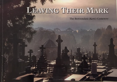
Book, Friends of Boroondara (Kew) Cemetery, Leaving their mark : a tribute to some of those who are memorialised in the Boroondara (Kew) Cemetery, est 1958, 2020
... The Boroondara General Cemetery, commonly known as the Kew Cemetery is only eight kilometres east of Melbourne's Central Business District, Kew Cemetery is an operating cemetery designed in the tradition of the Victorian garden cemetery. ...Kew Historical Society Inc Kew Court House 188 High Street Kew melbourne The Boroondara General Cemetery, commonly known as the Kew Cemetery is only eight kilometres east of Melbourne's Central Business District, Kew Cemetery is an operating cemetery designed in the tradition of the Victorian garden cemetery. ...xii, 108 pages : illustrations, portraits ; 21 x 30 cmnon-fictionburials -- boroondara general cemetery, funerary monuments -- kew (vic), cemeteries -- victoria -- kew -- history, kew (vic.) -- biography -
 Warrnambool and District Historical Society Inc.
Documents Maps (3) - Warrnambool Town Allotments, City of W'bool Parish of Wangoom Country of Villiers, 1948
... These maps were produced in 1948 and they contain maps of allotments within the city of Warrnambool, including the Central Business District, up to 1948. The details given on each allotment show the allotment and section numbers, the measurement in acres, the name of the original purchaser of the lot and the date of the first sale. ...Warrnambool and District Historical Society Inc. 2 Gilles Street (south of Merri St) Warrnambool great-ocean-road These maps were produced in 1948 and they contain maps of allotments within the city of Warrnambool, including the Central Business District, up to 1948. The details given on each allotment show the allotment and section numbers, the measurement in acres, the name of the original purchaser of the lot and the date of the first sale. ...These maps were produced in 1948 and they contain maps of allotments within the city of Warrnambool, including the Central Business District, up to 1948. The details given on each allotment show the allotment and section numbers, the measurement in acres, the name of the original purchaser of the lot and the date of the first sale. The Warrnambool and District Historical Society owns several copies of these maps but these ones are originals.These three maps are of great significance because they give the names of land purchasers in Warrnambool from the date of the first land sales in 1847. They are a most valuable research tool and can be scanned and photocopied etc.These are three sheets of cream paper pasted on to linen. The sheets have black and white printing and map work. Some of the edges are a little frayed and there is some staining, particularly on the backs of the sheets.‘City of Warrnambool Parish of Wangoom County of Villiers Sheet 1’ ‘City of Warrnambool Parish of Wangoom County of Villiers Sheet 2’ ‘City of Warrnambool Parish of Wangoom County of Villiers Sheet 3’city of warrnambool, warrnambool maps, warrnambool town allotments 1948, land purchases -
 Warrnambool and District Historical Society Inc.
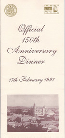
Document, Menu 150th, 1997
... The surveyor of the 250 acre grid that today comprises most of the Central Business District was William Pickering. The 150th anniversary celebrations were organized by an 150th Anniversary Committee headed by Frank Jacobs...The surveyor of the 250 acre grid that today comprises most of the Central Business District was William Pickering. The 150th anniversary celebrations were organized by an 150th Anniversary Committee headed by Frank Jacobs This program is of minor interest as a memento of the important 150th anniversary celebrations held in Warrnambool in 1997. ...This is the program for the dinner celebrating Warrnambool’s 150th anniversary. Warrnambool was established in 1847 as a planned town in response to the need for a new port to be established to service the pastoralists who had occupied land nearby. Superintendent La Trobe authorized the establishment of the town and probably gave it its name. The surveyor of the 250 acre grid that today comprises most of the Central Business District was William Pickering. The 150th anniversary celebrations were organized by an 150th Anniversary Committee headed by Frank JacobsThis program is of minor interest as a memento of the important 150th anniversary celebrations held in Warrnambool in 1997. This is a buff-coloured A3–size sheet folded into three to make six pages of printed material. These include sepia-tone photographs, the menu for the dinner, the official crest of the Warrnambool City Council and the 150th anniversary celebrations logoFront cover: ‘Official 150th Anniversary Dinner, 17th February 1997’warrnambool’s 150 anniversary celebrations -
 Victoria Police Museum
Police Stations (Altona North)
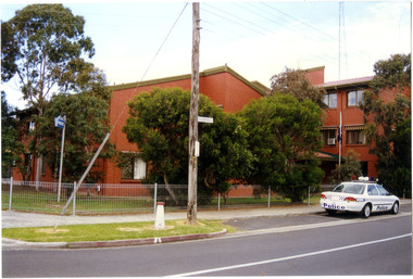
... Altona North is a suburb of Melbourne, Victoria, Australia, 10 km south-west of Melbourne's Central Business District, located within the City of Hobsons Bay local government area. ...Victoria Police Museum 313 Spencer Street Docklands melbourne Altona North is a suburb of Melbourne, Victoria, Australia, 10 km south-west of Melbourne's Central Business District, located within the City of Hobsons Bay local government area. ...Altona North is a suburb of Melbourne, Victoria, Australia, 10 km south-west of Melbourne's Central Business District, located within the City of Hobsons Bay local government area. Altona North Police Station opened on 7 October 1979 as a new twenty-four police station and was the District Headquarters of Altona District. It comprised a C.I.B. and a Community Policing Squad. It is located at 72 Cooper Avenue, on the corner of McArthurs Road. A new police station is being planned for Galvin Street, opening in 2020.2 colour photospolice stations; altona north police station -
 Federation University Historical Collection
Photograph - Colour, Leigh River near Garibaldi Bridge
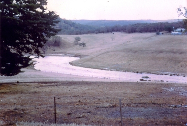
... The Leigh River rises below Mount Mercer and flows generally south, joined by three minor tributaries before reaching its confluence with the Barwon River, southeast of the central business district of Inverleigh. The river descends 265 metres (869 ft) over its 61-kilometre (38 mi) course. ...The Leigh River rises below Mount Mercer and flows generally south, joined by three minor tributaries before reaching its confluence with the Barwon River, southeast of the central business district of Inverleigh. The river descends 265 metres (869 ft) over its 61-kilometre (38 mi) course. ...The Leigh River is a major tributary and catchment of the Barwon River. Fed by the Yarrowee River that rises near Ballarat, the Yarrowee reaches its confluence to form the Leigh in the vicinity of Cambrian Hill and Golden Plains Shire. The Leigh River rises below Mount Mercer and flows generally south, joined by three minor tributaries before reaching its confluence with the Barwon River, southeast of the central business district of Inverleigh. The river descends 265 metres (869 ft) over its 61-kilometre (38 mi) course. (https://en.wikipedia.org/wiki/Leigh_River_(Victoria)Relates to historical information about flooding of the Leigh River in 1933. Relevant to the history of Garibaldi and Durham Lead.A number of colour photographs showing the Leigh River between Garibaldi and Durham Lead, Victoria, .1 - .3) photographs of the Leigh River in flood .4 - .18) general photos of the Leigh River and surrounding countryside .19) broad angle photograph of the Leigh River and surrounding countryside leigh river, garibaldi, garibaldi bridge, durham lead, vincent family -
 Bendigo Historical Society Inc.
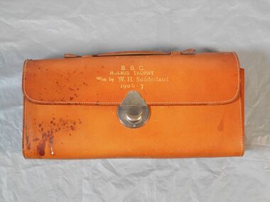
Award - B.B.C Trophy Holmes Trophy Men's Toiletry Set
... It is located in central Bendigo just a short walk through the picturesque Rosalind Park from Bendigo’s central business district. https://bendigobowlsclub.com.au/history/ William Henry Sunderland was a Bendigo investor, member of the Bendigo Stock Exchange and director of many mining companies. ...It is located in central Bendigo just a short walk through the picturesque Rosalind Park from Bendigo’s central business district. https://bendigobowlsclub.com.au/history/ William Henry Sunderland was a Bendigo investor, member of the Bendigo Stock Exchange and director of many mining companies. ...The Club known today as the Bendigo Bowls Club originated from the Sandhurst Bowling Club in 1870/71 changing its name to Bendigo in 1872. It is located in central Bendigo just a short walk through the picturesque Rosalind Park from Bendigo’s central business district. https://bendigobowlsclub.com.au/history/ William Henry Sunderland was a Bendigo investor, member of the Bendigo Stock Exchange and director of many mining companies. His father, George, had been a mounted trooper assigned as a gold escort between Melbourne and Bendigo. William became the President of the Bendigo Bowling Club in 1916.Leather satchel with gold embossed text. Text reads B.B.C Holmes Trophy. Won by W. H. Sunderland. 1906-7. Inside the satchel are eight items pertaining to a men's toiletry set. These include; a comb, a mirror, a clothing brush, a glass cylinder with metal lid, a small metal tin, a razor strop, a shoe hook and a soap case. Four items appear to be missing from the set. The satchel has a leather carry handle.B.B.C Holmes Trophy Won by W.H.Sunderland 1906-7bendigo bowling club, men's toiletry set -
 Kew Historical Society Inc
Clothing - Silk Organza Wedding Dress, Oggi Fashion House, 1971
... Janet Brock, who at the time was working in the Central Business District of Melbourne, had stopped to admire a mauve version of the dress that was displayed in the window, and, on making inquiries from the proprietress, ordered a made-to-measure cream-coloured copy. ...Janet Brock, who at the time was working in the Central Business District of Melbourne, had stopped to admire a mauve version of the dress that was displayed in the window, and, on making inquiries from the proprietress, ordered a made-to-measure cream-coloured copy. ...Fashion by Oggi, as the sign above the door proclaimed, was located at the Paris End of Collins Street, on the south side, virtually opposite Lilian Weightman’s Le Louvre boutique. Janet Brock, who at the time was working in the Central Business District of Melbourne, had stopped to admire a mauve version of the dress that was displayed in the window, and, on making inquiries from the proprietress, ordered a made-to-measure cream-coloured copy. Her marriage occurred shortly after the death of her father, and took place on 18 December 1971 at the Kew Presbyterian Church in Cotham Road, where the Rev. Peter Mackie was the celebrant. The Fashion & Design collection of the Kew Historical Society includes examples of women’s, men’s, children’s and infants’ clothing from the 18th, 19th and 20th centuries. Items in the collection were largely produced for, or purchased by women in Melbourne, and includes examples of outerwear, protective wear, nightwear, underwear and costume accessories.Wedding dress, purchased by Janet Elizabeth Brock in December 1971 from Oggi of Collins Street. The wedding dress, reaching just below the knee, is lined in silk with a double outer layer of organza. The striking decoration of the monochromatic cream dress is achieved through the use of wide ruffled organza frills at the neck, on the sleeves and at the flared hem of the dress. The dress has a discrete v-neckline with small, self-covered buttons at centre front. At the back, the dress is closed with a nylon zip. In addition to the elaborate stiffened frills, the dress features a wide fabric belt with a double bow, worn at the front. oggi - 103-105 collins street - melbourne (vic), women's clothing, wedding dresses, janet (brock) walker, australian fashion - 1970s -
 City of Moorabbin Historical Society (Operating the Box Cottage Museum)
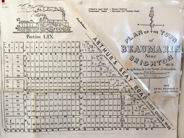
Document, photocopy of Plan of Beaumaris 1853, c1960
... Beaumaris is a suburb in Melbourne, Victoria, Australia, 19 km south-east from Melbourne's central business district. .Since the Amalgamation of Councils 1994 the local government area is the City of Bayside which includes Brighton. ...Beaumaris is a suburb in Melbourne, Victoria, Australia, 19 km south-east from Melbourne's central business district. .Since the Amalgamation of Councils 1994 the local government area is the City of Bayside which includes Brighton. moorabbin county of bourke brighton beaumaris pioneers early settlers. market gardeners cheltenham king. ...Beaumaris includes two early estates in the parish of Moorabbin developed by Josiah Holloway from 1852. Named Beaumaris Town and Beaumaris Estate (after the pastoral run in the area and ultimately after Beaumaris in Wales), the lots comprising them were marketed by Mr Holloway's suggesting that the railway was imminent and a canal would be built. The township developed slowly, a Post Office opened on 1 March 1868, but was replaced next month by Gipsy Village office (now Sandringham) In 1862 Beaumaris was one of the early settler communities within the boundaries of the Moorabbin District Roads Board , the region’s first local government authority. Beaumaris is a suburb in Melbourne, Victoria, Australia, 19 km south-east from Melbourne's central business district. .Since the Amalgamation of Councils 1994 the local government area is the City of Bayside which includes Brighton. A Photocopy of the Plan of Beaumaris 1853 A3moorabbin, county of bourke, brighton, beaumaris, pioneers, early settlers. market gardeners, cheltenham, king. john, holloway josiah, whorral charles, arthur’s seat road, nepean highway, morabbin district roads board, sandringham, mordialloc, mentone -
 Warrnambool and District Historical Society Inc.
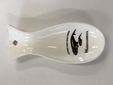
China, Spoon Rest, Early 21st century
... It is a souvenir of the presence of Southern Right whales at Logans Beach, a few kilometres from Warrnambool’s Central Business District. Each year Southern Right whales have been migrating from sub-Antarctic waters to the east coast of Australia during the winter months. ...It is a souvenir of the presence of Southern Right whales at Logans Beach, a few kilometres from Warrnambool’s Central Business District. Each year Southern Right whales have been migrating from sub-Antarctic waters to the east coast of Australia during the winter months. ...This spoon rest is a souvenir item for tourists to purchase. It is a souvenir of the presence of Southern Right whales at Logans Beach, a few kilometres from Warrnambool’s Central Business District. Each year Southern Right whales have been migrating from sub-Antarctic waters to the east coast of Australia during the winter months. Some whales have been coming each year from approximately May to October (since the 1980s) to have their calves at Logans Beach near Warrnambool. This area is now known as Warrnambool’s Southern Right Nursery. The whales calve about every three years and stay in the local waters along with other whales for about three months and over the past thirty years or so over 100 calves have been born at Logans Beach. The whales are now a winter tourist attraction (if an unpredictable one) as they can be viewed from a raised purpose-built platform area and they are often very close to the shore.This spoon rest is of interest as it is a souvenir of the Southern Right Whale Nursery at Logans Beach, Warrnambool and it has a practical use in the kitchen. It indicates the popularity of whale-viewing at Logans Beach and the importance of the presence of the whales, both scientifically and economically as the annual whale migration to our waters is now a vital aspect of tourism in Warrnambool. This is a Warrnambool souvenir cream-coloured china spoon rest in the shape of a whale or fish. It has a hole at the top for hanging the item on a hook and the printed material is in black and includes a sketch of a mother whale and calf. It has the distributor’s name on the back in yellow writing with an outline of a map of Victoria with a dot to show the location of Warrnambool.‘Southern Right Whale Nursery, Warrnambool’ ‘Lady Bay Creations, Warrnambool, Australia’ southern right whales, warrnambool’s southern right whale nursery, history of warrnambool -
 Victoria Police Museum
Police Stations (Armadale)
... Armadale is an inner suburb of Melbourne, Victoria, Australia, 7 km south-east of Melbourne's Central Business District, located within the City of Stonnington local government area. ...Victoria Police Museum 313 Spencer Street Docklands melbourne Armadale is an inner suburb of Melbourne, Victoria, Australia, 7 km south-east of Melbourne's Central Business District, located within the City of Stonnington local government area. ...Armadale is an inner suburb of Melbourne, Victoria, Australia, 7 km south-east of Melbourne's Central Business District, located within the City of Stonnington local government area. Armadale Police Station opened, in Melbourne Police District, on 11 May 1885. Its original location is unknown, but in 1890 it is listed in the Sands & McDougall directory as at 295 Hight Street. From 1985-1920 it was located at 20/22 Auburn Grove, 1925-1930 at 769 High Street and 1935-1946 at 3 Cheel Street. The station closed on 28 January 1946. The sub-division east of Orrong Rd was incorporated into Malvern Sub-district and west of Orrong Road into Prahran Sub-district. In a special 1930 issue of the Victoria Police Gazette the Armadale Police Station was described as a seven-roomed brick dwelling with a tiled roof on land measuring 127' x 104' x 98'. There was also a bathroom and W.C., a wash-house, office, and a lock-up (one cell). This is probably a description of the Cheel Street police station. It was staffed by one senior constable and three foot constables.12 photographs comprising 8 coloured images and 4 black and white images 1 sketch plan of Old Armadale Police Stationpolice stations; armadale police station