Showing 894 items matching "chartism"
-
 Flagstaff Hill Maritime Museum and Village
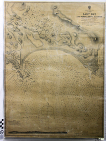
Document - Navigation Chart, Admiralty Office, Lady Bay and Warrnambool Harbour, 03/04/1871
... ...chart...This Chart titled “Lady Bay and Warrnambool Harbour” was surveyed by Nav. ...Directions for vessels entering Warrnambool Harbour are printed on the chart. The chart has a lacquer or seal over it....Top of chart has logo "HYDROGRAPHER OFFICE" "Price Eighteen Pence". ......Edward Weller, Chart Engraver...Richards Edward Weller Port of Warrnambool flagstaff Hill Maritime Museum & Village Maritime Museum Maritime Village shipwreck coast Map chart Navigation chart Admiralty Chart Breakwater Jetty Pier VHR H2024 Top of chart has logo "HYDROGRAPHER OFFICE" "Price Eighteen Pence". ...This Chart titled “Lady Bay and Warrnambool Harbour” was surveyed by Nav. Lieut. H.J. Stanley, of Britain's Royal Navy, in 1870 and printed in April 1871. The chart was made before the Warrnambool Breakwater was built (construction had begun in 1874 and was completed in 1890). The chart includes Directions for entering Lady Bay, Warrnambool Harbour. These are "Vessels entering Warrnambool Harbour must bring the Red Light in sight and steer in with it in line with the upper white Light bearing North, until the Green Light on the Jetty is opened, when steer towards it and anchor. The best anchorage is in 2 ¼ fms [fathoms)] of water, about a cable from ledge off Breakwater rock. Or where convenient, according to draught of water, only endeavouring to anchor as close as possible to Breakwater rock. It is not safe to enter or leave the Harbour in south westerly or Southerly gales.” This chart is significant for its strong connection to the maritime history of Warrnambool Harbour and Lady Bay, and eventually to the Warrnambool Breakwater. The Warrnambool Breakwater is registered as a place of significance on the Victorian Heritage Database (VHR H2024). A copy of the same chart was used to plan several submissions for future changes to the jetty and breakwater. The chart is a historical record of structures existing in 1870; the Warrnambool Jetties, Lady Bay, the leading lights (lighthouses), streets, roads, bridges and many buildings. It also shows the lay of the land and seabed.Canvas chart of Australia, South Coast, Victoria Title: Lady Bay and Warrnambool Harbour Surveyed by Nav. Lieut. H.J. Stanley, R.N., 1870. Magnet Variation, 1870 Published April 3, 1871, by the Admiralty, London. Directions for vessels entering Warrnambool Harbour are printed on the chart. The chart has a lacquer or seal over it.Top of chart has logo "HYDROGRAPHER OFFICE" "Price Eighteen Pence". "Engraved by Edward Weller" Along bottom of Chart: “London… Published at the Admiralty, 3rd April 1871, under the Superintendence of Rear Admiral G.H. Richards, F.R.S. Hydrographer, Corrections July 71” Bottom of chart “Australia South Coast Victoria Lady Bay and Warrnambool Harbour. 2494”flagstaff hill, warrnambool, chart of lady bay warrnambool 1870, warrnambool harbour, cartography, navigation, warrnambool breakwater, 1871, australia – south coast / victoria, lady bay, 1870, nav. lieut. h.j. stanley, r.n, directions for entering warrnambool harbour, hydrographer office, rear admiral g.h. richards, edward weller, port of warrnambool, flagstaff hill maritime museum & village, maritime museum, maritime village, shipwreck coast, map, chart, navigation chart, admiralty chart, breakwater, jetty, pier, vhr h2024 -
 Flagstaff Hill Maritime Museum and Village
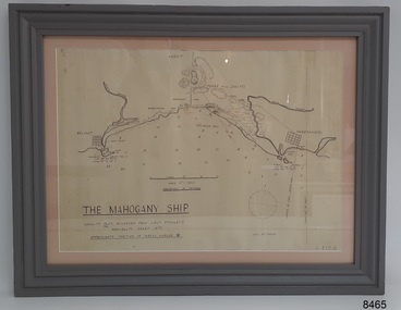
Document - Location Chart, The Mahogany Ship, 2007
... This chart shows a possible site for the fabled wreck called the 'Mahogany Ship'. ...The chart is a copy and is based on the Admiralty Chart by Lieut. ...STANLEY'S ADMIRALTY CHART 1872" "APPROXIMATE POSITION OF WRECK MARKED [symbol of a Portuguese cross]" Other labels on chart: "BELFAST" "PORT FIARY" "GRIFFITHS I" "RIVER MOYNE" "RIVER MERRI" "ARMSTRONG BAY" " GORMANS LANE" "TOWER HILL" "KOROIT" "HELEN ROCK" "WARRNAMBOOL" "LADY BAY" "MIDDLE I" "LIGHT HO." ...The chart is a copy and is based on the Admiralty Chart by Lieut. ...This chart shows a possible site for the fabled wreck called the 'Mahogany Ship'. Flagstaff Hill’s collection includes other objects that some say could be relics from this Ancient Wreck, (also called the Gold Ship, or the Ancient Vessel). The chart shows the coordinates for the Summits of Griffith Island and of Middle Island. It also has the depths of the sea at various intervals and shows the shore and sand dunes, lighthouses and other reference points. The mystery of the Mahogany Ship began in 1836 when two shipwrecked sealers discovered the remains of an “ancient vessel” in the sand dunes about four miles west of Warrnambool. Since the last recorded sightings in the 1880’s the true origin of the Mahogany Ship has remained one of Australia’s most famous historical mysteries or fables. One of the more recent theories is that the vessel was one of the Portuguese ships exploring the Australian coast in 1522. For over one hundred years searchers have attempted to locate and identify the wreck. The search continues for the tangible evidence which will once and for all establish the Mahogany Ship’s place in Australia’s History.The chart represents the worldwide interest in locating the wreck of the Mahogany Ship. Locating the actual wreck or proving the existence of a Portuguese ship's wreck could change the history of the discovery of Australia. A Mahogany Ship committee was formed to gather and research information about the discovery of the wrecked ship. A large amount of money was offered as a prize for finding the wreck or parts of it. People have written books, painted images, made videos and told tales of the ship but it continues to remain a mystery or even a fable. The chart is significant for its possible link to one of Victoria’s and Australia’s maritime mysteries, the Mahogany Ship (also known as the Ancient Wreck). It is one of very few known relics that could give evidence of the existence and history of the vessel. It is listed on the Victorian Heritage Register S438 as it is one of Victoria’s oldest recorded shipwrecks. The identity of the vessel has the potential to change Australia’s history.A chart in a wooden frame, behind glass. The chart shows the approximate position of the mystery Ancient Wreck, later called the "Mahogany Ship". The chart is a copy and is based on the Admiralty Chart by Lieut. Stanley, dated 1872. Lower left: "THE MAHOGANY SHIP" "LOCALITY PLAN, ENLARGED FROM LIEUT. STANLEY'S ADMIRALTY CHART 1872" "APPROXIMATE POSITION OF WRECK MARKED [symbol of a Portuguese cross]" Other labels on chart: "BELFAST" "PORT FIARY" "GRIFFITHS I" "RIVER MOYNE" "RIVER MERRI" "ARMSTRONG BAY" " GORMANS LANE" "TOWER HILL" "KOROIT" "HELEN ROCK" "WARRNAMBOOL" "LADY BAY" "MIDDLE I" "LIGHT HO." Lower right: "G 410 B" Label on the back; "This chart presented to the Mahogany Ship Committee and Flagstaff Hill by Avis Quarrell, April 2007"warrnambool, shipwrecked coast, flagstaff hill maritime museum, shipwreck coast, mahogany ship, ancient vessel, ancient wreck, portuguese ship, coastal reserve, fabled wreck, gold ship, griffiths island, belfast (now port fairy), koroit, location plan, leuit. stanley, admiralty chart 1872, tower hill, merri river, moyne river, middle island, helen rock, armstrong bay, griffiths land -
 Victorian Aboriginal Corporation for Languages
Book, David Ellyard et al, The southern sky guide, 2001
... Gives detailed charts of the sky in two weekly segments....maps, charts, colour illustrations...Victorian Aboriginal Corporation for Languages 33 Saxon Street Brunswick melbourne astronomy constellations stars maps, charts, colour illustrations Gives detailed charts of the sky in two weekly segments. ...Gives detailed charts of the sky in two weekly segments.maps, charts, colour illustrationsastronomy, constellations, stars -
 Ambulance Victoria Museum
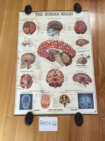
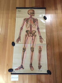
Chart, medical, human body, brain, Merck Sharpe and Dohme, The Human Brain
... Rectangular chart made from glossy paper with colour printing. ...The word 'BRAIN' is hand written on the reverse of the chart in black texter pen....The strip on the upper edge has a loop used for hanging the chart. The Human Brain Chart, medical, human body, brain Merck Sharpe and Dohme ...Rectangular chart made from glossy paper with colour printing. The chart is mounted at either end on black metal strips. The strip on the upper edge has a loop used for hanging the chart.The word 'BRAIN' is hand written on the reverse of the chart in black texter pen.merck, merck sharpe and dohme, human brain, medical chart -
 Ambulance Victoria Museum
Chart, medical, human body, blood circulation, J. Teck
... Rectangular medical chart showing the upper part of the human body, skeleton, organs and blood circulation.The chart is made from printed paper on a fabric (?...The artists name 'J.Teck' is included on the lower edge on the front of the chart (LHS). The logo of the St John's Ambulance Association and the words 'ST JOHN'S GATE, LONDON E.C. 1' are printed on the lower edge of the chart (on the front of the chart at RHS). ...Chart, medical, human body, blood circulation J. ...Rectangular medical chart showing the upper part of the human body, skeleton, organs and blood circulation.The chart is made from printed paper on a fabric (?cotton) base and is attached with metal tacks to timber batons at each end . The timber batons are stained black. A strip of red cotton tape is attached to the mid-part of the upper baton and has been used to secure the chart when it is rolled up. Metal ring eyelets are screwed into either end of the upper baton and were used to hang the chart.The artists name 'J.Teck' is included on the lower edge on the front of the chart (LHS). The logo of the St John's Ambulance Association and the words 'ST JOHN'S GATE, LONDON E.C. 1' are printed on the lower edge of the chart (on the front of the chart at RHS). The words 'BLOOD CIRCULATION' are written in blue ink on the top margin of the chart on the reverse side.medical chart, human body, blood circulation, j. teck -
 Bendigo Military Museum
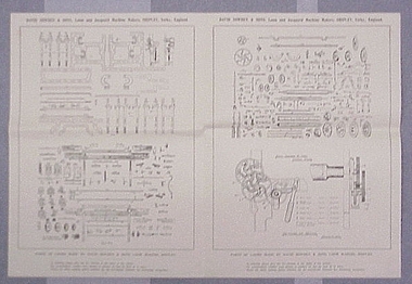
Map - RASvy " Map Makers Exhibition 2025 "- Map display, RAN Hydrographic Office, 1972 - 1992
... These charts were produced and printed at the Army Survey Regiment, Bendigo. .4 RAAF LONG RANGE PLOTTING CHART. ....1 Tactical Pilotage Chart Series Catalogue. Current as at 30 Jun 92. .2 Extract of Navigational Plotting Chart " NP22-2 Tasmania " .3 Extract of Navigational Plotting Chart " NP 27 RAAF PLOTTING CHART AUSTRALIA - SOUTHEAST " .4 Extract of Navigational Plotting Chart " RAAF LONG RANGE PLOTTING CHART NP43-4 AUSTRALIA WESTERN " .5 Extract of Navigational Plotting Chart " RAAF LONG RANGE PLOTTING CHART NP43-7 SOLOMON ISLANDS " .6 Extract of Navigational Series " RAAF AIR STAFF PLANNING CHART NS 137-2 DARWIN NORTH WEST " .7 Extract of Navigational Series " RAAF AIR STAFF PLANNING CHART NS 137-1 DARWIN NORTH EAST " .8 Extract of Navigational Series " RAAF AIR STAFF PLANNING CHART NS 137-4 DARWIN SOUTH WEST " .9 Extract of Navigational Series " RAAF AIR STAFF PLANNING CHART NS 137-3 DARWIN SOUTH EAST " .10 Extract of Tactical Pilotage Chart " TPC R-13B " .11 Extract of Hydrographic Chart " PORT PHILLIP SOUTH and WEST CHANNELS " .12 Extract of Hydrographic Chart " GEELONG HARBOUR and APPROACHES " .13 Extract of En Route Chart " AUSTRALIA ERC HIGH " " H1 and H2 " ...These charts were produced and printed at the Army Survey Regiment, Bendigo. .4 RAAF LONG RANGE PLOTTING CHART. ...All of these Charts / Maps were used for the RSL Museum display " The Mapmakers " ( of RASvy. ) 10 Jun - 10 Aug 2025. .1 Catalogue of Tactical Pilotage Charts, 1:500 000 Scale. Digital Data Base available as at 30Jun 92. This catalogue page shows the extent of the Australian area of responsibility for aeronautical charting. .2 RAAF PLOTTING CHART. NP 22-2 (Navigational Plotting) Tasmania. MERCATOR PROJECTION. This series of charts were used for the training of RAAF Navigators. These charts were produced and printed at the Army Survey Regiment, Bendigo. .3 RAAF PLOTTING CHART AUSTRALIA - SOUTHEAST. NP 27 is Based on LAMBERT CONFORMAL CONIC PROJECTION. This series of charts was used by RAAF Navigators for the planning of RAAF flights. These charts were produced and printed at the Army Survey Regiment, Bendigo. .4 RAAF LONG RANGE PLOTTING CHART. NP 43-4 AUSTRALIA WESTERN. MERCATOR PROJECTION. This series of maps were used for the planning of RAAF flights. Of Particular note these charts were used to plot "Rhumb Lines or loxodromes" where a course crosses all Meridians (Lines of latitude and longitude) at the same angle. On Mercator projection charts Rhumb lines are conveniently shown as straight lines and are also lines of constant compass bearing. Rhumb lines are usually longer than the shortest distance between two points. The shortest distance between two points on the earth's surface is called a "Great Circle Route" which is a route on a circular path on the surface of the earth where the centre of that circle is also the centre of the earth. Great Circle Routes on a Mercator Projection are however curves and harder to plot. These charts were produced and printed at the Army Survey Regiment, Bendigo. .5 RAAF LONG RANGE PLOTTING CHART. NP 43-7 SOLOMON ISLANDS. MERCATOR PROJECTION. Used for the planning of RAAF flights. .6 RAAF AIR STAFF PLANNING CHART NS 137-1 DARWIN NORTH WEST. AZIMUTHAL EQUIDISTANT PROJECTION. This series of charts were used for planning by the staff. The whole chart was produced by joining the four quadrant maps together. The charts are based on a single point of tangency (in this case Darwin) and shows radius (distance) in nautical miles to and from that point. A series of charts were produced centred on each of the major airfields in Northern Australia. These charts were produced and printed at the Army Survey Regiment, Bendigo. .7 RAAF AIR STAFF PLANNING CHART NS 137-2 DARWIN NORTH EAST. AZIMUTHAL EQUIDISTANT PROJECTION. Used for the planning by the staff. The charts are based on a point of tangency and show radius in nautical miles. .8 RAAF AIR STAFF PLANNING CHART NS 137-4 DARWIN SOUTH WEST. AZIMUTHAL EQUIDISTANT PROJECTION. Used for the planning by the staff. The charts are based on a point of tangency and show radius in nautical miles. .9 RAAF AIR STAFF PLANNING CHART NS 137-3 DARWIN SOUTH EAST. AZIMUTHAL EQUIDISTANT PROJECTION. Used for the planning by the staff. The charts are based on a point of tangency and show radius in nautical miles. .10 TACTICAL PILOTAGE CHART. TPC R-13B. LAMBERT CONFORMAL PROJECTION. Used by pilots for flight planning and could be used in flight if necessary for visual navigation using major ground features shown on the chart. These charts also contained aeronautical information such as airfields, radio navigation beacons and obstructions. Contours and height information was shown in feet to be compatible with aircraft altimeters. Each graticule square also contained a Maximum Safe Elevation Figure (MEF) also in feet. Coverage of this series over Australia's area of interest were produced and printed at the Army Survey Regiment, Bendigo. .11 HYDROGRAPHIC CHART. AUS 158. PORT PHILLIP SOUTH and WEST CHANNELS. PROJECTION TRANSVERSE MERCATOR. Used by all people needing to navigate a vessel. Hydrographic charts were printed at the Army Survey Regiment, Bendigo. .12 HYDROGRAPHIC CHART. AUS 157. GEELONG HARBOUR and APPROACHES. PROJECTION TRANSVERSE MERCATOR. Used by all people needing to navigate a vessel. .13 EN ROUTE CHART. AUSTRALIA ERC HIGH. H1 and H2. LAMBERT CONFORMAL CONIC PROJECTION. This series of charts were regularly produced by the RAAF Aeronautical Information Service (AIS) and contained current aeronautical information for pilots. These charts were printed at the Army Survey Regiment, Bendigo..1 Tactical Pilotage Chart Series Catalogue. Current as at 30 Jun 92. .2 Extract of Navigational Plotting Chart " NP22-2 Tasmania " .3 Extract of Navigational Plotting Chart " NP 27 RAAF PLOTTING CHART AUSTRALIA - SOUTHEAST " .4 Extract of Navigational Plotting Chart " RAAF LONG RANGE PLOTTING CHART NP43-4 AUSTRALIA WESTERN " .5 Extract of Navigational Plotting Chart " RAAF LONG RANGE PLOTTING CHART NP43-7 SOLOMON ISLANDS " .6 Extract of Navigational Series " RAAF AIR STAFF PLANNING CHART NS 137-2 DARWIN NORTH WEST " .7 Extract of Navigational Series " RAAF AIR STAFF PLANNING CHART NS 137-1 DARWIN NORTH EAST " .8 Extract of Navigational Series " RAAF AIR STAFF PLANNING CHART NS 137-4 DARWIN SOUTH WEST " .9 Extract of Navigational Series " RAAF AIR STAFF PLANNING CHART NS 137-3 DARWIN SOUTH EAST " .10 Extract of Tactical Pilotage Chart " TPC R-13B " .11 Extract of Hydrographic Chart " PORT PHILLIP SOUTH and WEST CHANNELS " .12 Extract of Hydrographic Chart " GEELONG HARBOUR and APPROACHES " .13 Extract of En Route Chart " AUSTRALIA ERC HIGH " " H1 and H2 " royal australian survey corps, rasvy, fortuna, detachment - army survey regiment, army svy regt, asr -
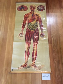 Ambulance Victoria Museum
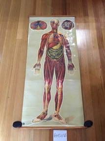
Chart, medical, human body, muscles and organs
... Rectangular medical chart showing the human body, muscles and organs.The chart is made from coated and printed paper on a fabric (?...The artists name 'J.Teck' is included on the lower edge on the front of the chart. The logo of the St John's Ambulance Association and the words 'ST JOHN'S GATE, LONDON E.C. 1' are printed on the lower edge of the chart (left hand side on the front of the chart). ...Ambulance Victoria Museum 1/55 Barry Street Bayswater melbourne medical chart human body j.teck The artists name 'J.Teck' is included on the lower edge on the front of the chart. ...Rectangular medical chart showing the human body, muscles and organs.The chart is made from coated and printed paper on a fabric (?cotton) backing and is attached with metal tacks to timber batons at each end . A strip of red cotton tape is attached to the mid-part of the upper baton and has been used to secure the chart when it is rolled up. Metal ring eyelets are screwed into either end of the upper baton and were probably used to assist when hanging the chart.The artists name 'J.Teck' is included on the lower edge on the front of the chart. The logo of the St John's Ambulance Association and the words 'ST JOHN'S GATE, LONDON E.C. 1' are printed on the lower edge of the chart (left hand side on the front of the chart). The words 'FULL BODY INC LIMBS' is written in black texter pen on the upper baton. The words 'ORGANS, MUSCLES' have been written on the top margin of the chart on the reverse side.medical chart, human body, j.teck -
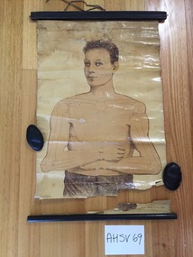 Ambulance Victoria Museum
Chart, medical, human body, Ruddiman, Johnston & CO., Ltd
... The chart shows the upper torso of a human male. ...Printed on the RHS front face of the chart at bottom edge are the words 'All rights reserved'. ...The chart shows the upper torso of a human male. ...Rectangular chart made from printed and coated paper on a fabric base. The chart shows the upper torso of a human male. The chart is mounted at either end on timber batons using small metal tacks. Masking tape has been placed over the metal tacks in an attempt to repair the chart. The upper baton is moulded, while the lower baton is circular in cross-section. Both batons are stained black.Two screwed metal eyelets have been attached at either end of the upper baton for use in hanging the chart. A short length of brown/white cotton tape is attached to the mid-point of the upper baton with a metal tack. the tape is used to secure the chart after it has been rolled up.Printed on the RHS front face of the chart at bottom edge are the words 'All rights reserved'. Printed on the LHS front face of the chart at bottom edge are the words 'RUDDIMAN, JOHNSTON & CO., Ltd., LONDON'ruddiman johnston & co, medical chart -
 Dandenong & District Historical Society
Bland Family, Bland Family - Rainfall Charts
... Bland Family - Rainfall Charts...Bland Family - Rainfall Charts...Dandenong & District Historical Society 1st Floor, 39 Clow Street Dandenong melbourne Bland Family - Rainfall Charts Bland Family - Rainfall Charts Bland Family - Rainfall Charts Bland Family ...Bland Family - Rainfall Charts -
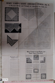 Embroiderers Guild, Victoria
Ephemera - Mary Card Waratah chart, Fitchett Bros. Pty. Ltd, Mary Card's Giant Crochet Charts - No. 8 A Waratah Border and Triangle for Afternoon-Tea Cloth, etc, 27/4/1918
... Chart used by donor's mother, Annie Gordon, to make Waratah Tea Cloth (L0084) before 1920....Paper chart glued to white fabric. Includes b/w photos, working charts & instruction....Cloth - Pattern Paper chart glued to white fabric. Includes b/w photos, working charts & instruction. ...Chart used by donor's mother, Annie Gordon, to make Waratah Tea Cloth (L0084) before 1920.Decent condition considering its age and that it was used. Direct connection to Lace Collection piece. Australian designer.Paper chart glued to white fabric. Includes b/w photos, working charts & instruction.Mrs Betty Whiting, 1 Kalimna Drive, Mildura, 3500. Made by her mother, Annie Gordon. Cloth - Patternmary card, filet crochet chart -
 Ambulance Victoria Museum
Chart, medical, human body, general anatomy
... Rectangular chart made from printed and coated paper on a fabric base. ...The artists name 'J.Teck' is printed near the bottom edge of the chart in the centre. ...The tape is used to secure the chart after it has been rolled up. Chart, medical, human body, general anatomy ...Rectangular chart made from printed and coated paper on a fabric base. The chart is mounted at either end on timber batons using small metal tacks. The upper baton is moulded while the lower baton is circular in cross-section. Two screwed metal eyelets have been attached at either end of the upper baton for use in hanging the chart. A short length of white cotton tape is attached to the mid-point of the upper baton with a metal tack. The tape is used to secure the chart after it has been rolled up.The logo of the St John Ambulance Association is printed on the bottom edge of the chart (LHS) along with the words 'ST JOHN'S GATE, LONDON E.C.1'. The artists name 'J.Teck' is printed near the bottom edge of the chart in the centre. medical chart, human body, anatomy -
 Ballarat Tramway Museum
Document - Charts, Public Transport Corporation (PTC), 671 Brake testing charts, 20/02/1996 12:00:00 AM
... From a machine set up to measure de acceleration. 275.1 - Test results for 25psi and 39 psi application - driver WAD - 125H x 820 long 275.2 - test results for full service application - 125H x 600 long. Photocopy of charts made at the time. Images of charts added 22/10/2013 See Fares Please! ...various notes regarding pressures etc. on chart....Tramways trams W4 class Brake Charts Testing Tramcar Brakes various notes regarding pressures etc. on chart. ...Demonstrates how tramcar braking performance could be measured mid 1990's.Original chart outputs of brake testing carried out by Met Tram (Mal Ashworth & Les Jeans) on tram 671 on 20/2/1996 - following installation of composite brake shoes. From a machine set up to measure de acceleration. 275.1 - Test results for 25psi and 39 psi application - driver WAD - 125H x 820 long 275.2 - test results for full service application - 125H x 600 long. Photocopy of charts made at the time. Images of charts added 22/10/2013 See Fares Please! March 1996various notes regarding pressures etc. on chart.tramways, trams, w4 class, brake charts, testing, tramcar brakes -
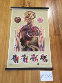
 Ambulance Victoria Museum
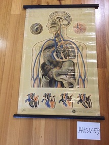
Chart, medical, blood circulation and heart, J. Teck
... Rectangular medical chart made from printed and coated paper laid on white fabric (?...Teck) is printed at the bottom LHS of the chart . The logo of the St John's Ambulance Association is printed on the RHS of the lower edge of the chart, along with the words 'St JOHN'S GATE, LONDON, E.C.1'...Chart, medical, blood circulation and heart J. ...Rectangular medical chart made from printed and coated paper laid on white fabric (?cotton) and showing the upper part of the human body, with skeleton, organs and blood circulation. The chart is attached to two wooden batons with small metal tacks. The top baton is moulded while the lower baton is circular in cross-section. Both batons are stained black. There are two screwed metal eyelets attached to the upper baton used for hanging the chart. A short length of red cotton tape is attached to the mid point of the upper baton with a metal tack and is used for securing the chart when it is rolled up. There is the remnant of a printed paper label adhered on the reverse side of the chart at the top edge, but unable to read the writing.The artists name (J. Teck) is printed at the bottom LHS of the chart . The logo of the St John's Ambulance Association is printed on the RHS of the lower edge of the chart, along with the words 'St JOHN'S GATE, LONDON, E.C.1'medical chart, blood circulation -
 Harcourt Valley Heritage & Tourist Centre
Fruit Packing Chart, 1968
... If the packer followed the chart the count was determined from the chart by reference to the diameter of the fruit as it came off the grader. ...Chart- two-sided black text on white paper pasted to backing board depicting columns and figures describing the required measurements for packing Rome Beauty Apples and Granny Smith Apples. 1 x pink foolscap card with black type, 1 x green foolscap card, 1 x yellow double sided foolscap card ...Packing Chart for Rome Beauty Apples in Friday Moulded Trays Telescopic Carton Inside Measurements 19 3/4" x 11 7/8" x 11 1/2". ...If the packer followed the chart the count was determined from the chart by reference to the diameter of the fruit as it came off the grader. ...Published by Dept. of Agriculture Division of Horticulture Victoria. Harcourt district exported immense quantities of apples and pears, each box containing fruit that had been sized (by diameter) so as to have uniform-sized fruit in the box, wrapped in tissue paper, all packed base- or stem-end against the cheek of its neigbouring piece, to restrict movement/bruising of the apples in transit. A colourful label on the end of the box had a space to insert the size and count, i.e. the number of pieces of fruit in the box. If the packer followed the chart the count was determined from the chart by reference to the diameter of the fruit as it came off the grader. Harcourt’s reputation for quality fruit was enhanced by the ability to deliver uniform-sized blemish-free and unbruised fruit which then attained premium prices in the market, contributing to the prosperity of the district. The packing chart was a vital aid In order to achieve this.Chart- two-sided black text on white paper pasted to backing board depicting columns and figures describing the required measurements for packing Rome Beauty Apples and Granny Smith Apples. 1 x pink foolscap card with black type, 1 x green foolscap card, 1 x yellow double sided foolscap card Packing Chart for Rome Beauty Apples in Friday Moulded Trays Telescopic Carton Inside Measurements 19 3/4" x 11 7/8" x 11 1/2". W. H. Harris Senior Fruit Packing Instructor August 1968. The same wording appears on the opposite side of chart with the words Granny Smith apples replacing Rome Beauty Apples -
 Ambulance Victoria Museum
Chart, medical, human body, the skeleton, J.Teck
... Rectangular chart made from printed and coated paper on a fabric base. ...A printed paper label is attached to the reverse of the chart bearing the words 'THE SKELETON'. The logo of the St John Ambulance Association and the words 'ST JOHN'S GATE, LONDON E.C.1' are printed on the botton edge of the chart (LHS). ...Chart, medical, human body, the skeleton J.Teck ...Rectangular chart made from printed and coated paper on a fabric base. The chart is mounted at either end on timber batons using small metal tacks. The upper baton is moulded while the lower baton is circular in cross-section. Both batons are stained black.Two screwed metal eyelets have been attached to the upper baton for use in hanging the chart. A short length of redcotton tape is attached to the mid-point of the upper baton with a metal tack. the tape is used to secure the chart after it has been rolled up.A printed paper label is attached to the reverse of the chart bearing the words 'THE SKELETON'. The logo of the St John Ambulance Association and the words 'ST JOHN'S GATE, LONDON E.C.1' are printed on the botton edge of the chart (LHS). The artists name 'J. Teck' is printed just above. A second, unknown logo is printed on the top LH corner of the chart. Much of it has flaked off so it is not possible to read it.medical chart, human body, j.teck -
 Flagstaff Hill Maritime Museum and Village
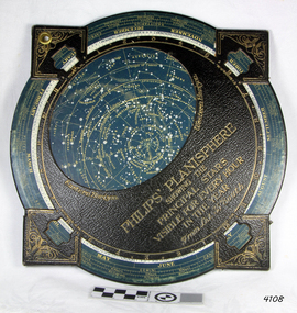
Planisphere, Early 20th Century
... The word describes the representation of the star-filled celestial sphere on the plane. The first star chart to have the name "Planisphere" was made in 1624 by Jacob Bartsch. ...The chart and overlay are mounted so that they are free to rotate about a common pivot point at their centers. ... "Sold by J DONNE & SON, Booksellers & Stationers, 349 Post Office Place Melbourne 349. Admiralty Chart Agents" and " Made in Germany for George Philip & Son Ltd" England . ...The chart and overlay are mounted so that they are free to rotate about a common pivot point at their centers. ...The word Planisphere (Latin planisphaerium) was originally used in the second century by Claudius Ptolemy to describe the representation of a spherical Earth by a map drawn in the plane. This usage continued into the Renaissance: for example Gerardus Mercator described his 1569 world map as a Planisphere. The word describes the representation of the star-filled celestial sphere on the plane. The first star chart to have the name "Planisphere" was made in 1624 by Jacob Bartsch. Bartsch was the son-in-law of Johannes Kepler, discoverer of Kepler's laws of planetary motionA significant item of celestial mapping used by marine navigators This particular item was made and used in the first quarter to half of the 20th century.Planisphere consists of a circular star chart attached at its centre to an opaque circular overlay that has a clear elliptical window or hole so that only a portion of the sky map will be visible in the window or hole area at any given time. The chart and overlay are mounted so that they are free to rotate about a common pivot point at their centers. The star chart contains the brightest stars, constellations and (possibly) deep-sky objects visible from a particular latitude on Earth. The night sky that one sees from the Earth depends on whether the observer is in the northern or southern hemispheres and the latitude. A Planisphere window is designed for a particular latitude and will be accurate enough for a certain band either side of that. Planisphere makers will usually offer them in a number of versions for different latitudes. Planispheres only show the stars visible from the observer's latitude; stars below the horizon are not included. A complete twenty-four-hour time cycle is marked on the rim of the overlay. A full twelve months of calendar dates are marked on the rim of the star chart. The window is marked to show the direction of the eastern and western horizons. The disc and overlay are adjusted so that the observer's local time of day on the overlay corresponds to that day's date on the star chart disc. The portion of the star chart visible in the window then represents (with a distortion because it is a flat surface representing a spherical volume) the distribution of stars in the sky at that moment for the Planispheres designed location. Users hold the Planisphere above their head with the eastern and western horizons correctly aligned to match the chart to actual star positions. "Sold by J DONNE & SON, Booksellers & Stationers, 349 Post Office Place Melbourne 349. Admiralty Chart Agents" and " Made in Germany for George Philip & Son Ltd" England . Signature "Capt E. B. ?..id, 22 Baund St"flagstaff hill, warrnambool, shipwrecked-coast, flagstaff-hill, flagstaff-hill-maritime-museum, maritime-museum, shipwreck-coast, flagstaff-hill-maritime-village, star map, marine navigation, maps, george philip & sons -
 Bendigo Military Museum
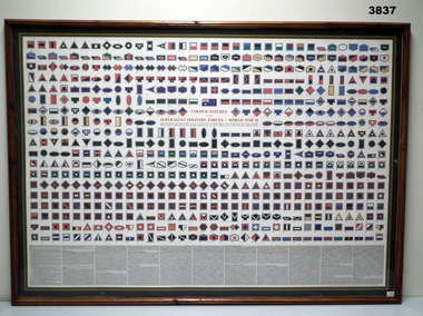
Print - CHART, FRAMED
... This chart displays unit colour patches worn by members of the Australia Military forces during World War 11. ...Chart: Paper, colour illustrations of the " Colour Patches" with black printed numbers 1 - 630. ...Printed in red ink on chart, COLOUR PATCHES/ OF THE/ AUSTRALIAN MILITARY FORCES - WORLD WAR 11. ...Small adhesive labels on front and back. Print CHART, FRAMED ...This chart displays unit colour patches worn by members of the Australia Military forces during World War 11. The Australian Military Forces consisted of the 2nd Australian Imperial Force, The Citizens Military Forces and the Permanent Military Force.Chart: Paper, colour illustrations of the " Colour Patches" with black printed numbers 1 - 630. Information on "Colour Patches" printed below illustrations in black ink. Mount: - cardboard, black with gold inner edge. Frame: Timber, mid brown colour with varnish finish. Decorative edge with perspex front. Backing: timber plywood, paper delivery docket adhered to backing. Small adhesive labels on front and back.Printed in red ink on chart, COLOUR PATCHES/ OF THE/ AUSTRALIAN MILITARY FORCES - WORLD WAR 11. Small adhesive labels, white, printed back ink "74".print, ww11, military, uniforms -
 Ambulance Victoria Museum
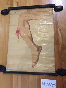
Chart, medical, human body, right leg fracture
... Rectangular medical chart made from printed and coated paper laid on white fabric (?...Printed on the RHS front face of the chart at bottom edge are the words 'All rights reserved'. ...Ambulance Victoria Museum 1/55 Barry Street Bayswater melbourne medical chart human body Printed on the RHS front face of the chart at bottom edge are the words 'All rights reserved'. ...Rectangular medical chart made from printed and coated paper laid on white fabric (?cotton) and showing a fracture to the right leg. The chart is attached to two wooden batons with masking tape. The top baton is moulded while the lower baton is circular in cross-section. Both batons are stained black. Printed on the RHS front face of the chart at bottom edge are the words 'All rights reserved'. Printed on the LHS front face of the chart at bottom edge are the words 'RUDDIMAN, JOHNSTON & CO., Ltd., LONDON'medical chart, human body -
 Creswick Campus Historical Collection - University of Melbourne
Document, 1972
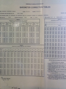
... Chart date of 1972 - refers to Barometer calibrated in 1948. ...Barometer Correction Tables - Chart...(Leon Bren) Barometer Correction Tables - Chart Document Document ...Chart date of 1972 - refers to Barometer calibrated in 1948. Has been on wall in corridor outside Science lab in University Building. (Leon Bren)Barometer Correction Tables - Chart -
 Greensborough Historical Society
Article - Genealogical document, Beale of St Helena, 1980s
... Family history chart of Anthony Beale and his family, pioneers of the St Helena area of Greensborough....4 pages, text only, genealogical chart (copy) ...Greensborough Historical Society 34A Glenauburn Road Lower Plenty Lower Plenty melbourne Family history chart of Anthony Beale and his family, pioneers of the St Helena area of Greensborough. ...Family history chart of Anthony Beale and his family, pioneers of the St Helena area of Greensborough.The St Helena area was named after the island on which Anthony Beale was born and worked. St Katherine's Church was named for his wife Katherine Rose.4 pages, text only, genealogical chart (copy) anthony beale, st helena, st katherines church, beale family -
 Flagstaff Hill Maritime Museum and Village
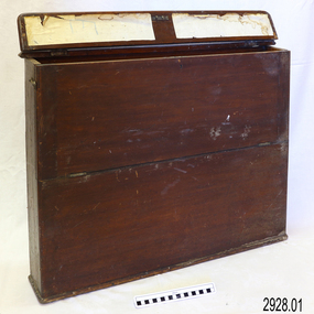
Container - Chart Case, Late 19th to early 20th centuries
... This case was donated along with the contents of over 60 navigational charts for locations all over the world. The narrow box is built to keep the charts in order and easily accessible on board a vessel. ...Chart case (or map case), wooden, has hinged opening at top. ...The chart case is a rare example of a container used on board a vessel for the storage and protection of navigational charts. ...This case was donated along with the contents of over 60 navigational charts for locations all over the world. The narrow box is built to keep the charts in order and easily accessible on board a vessel. The chart case is a rare example of a container used on board a vessel for the storage and protection of navigational charts. It represents the type of equipment used by the navigator of a seafaring vessel. The charts within the case represent the places to which the vessel travelled.Chart case (or map case), wooden, has hinged opening at top. Front of case folds down and has a hook closure. It contained 65 British Admiralty navigational charts, which are listed and stored separately. (See separate items 2928.2 to 2928.66)There is a hand written name on the back of the case.flagstaff hill, warrnambool, shipwrecked coast, flagstaff hill maritime museum, maritime museum, shipwreck coast, flagstaff hill maritime village, great ocean road, map case, chart case, map box, chart box, british admiralty charts, navigational charts, hydrographer charts, navigation, ship equipment -
 Flagstaff Hill Maritime Museum and Village
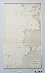
Document - Navigation Chart, Portsmouth to Canary Islands, Ca. 1928
... ...chart...This is an Official British Admiralty Navigation Chart, one of a set of 65 charts donated together with a wooden chart case. ...British Admiralty Navigation Chart - Portsmouth to Canary Islands - printed on rectangular white paper. ...Flagstaff Hill Maritime Museum and Village 89 Merri Street Warrnambool great-ocean-road This is an Official British Admiralty Navigation Chart, one of a set of 65 charts donated together with a wooden chart case. ...This is an Official British Admiralty Navigation Chart, one of a set of 65 charts donated together with a wooden chart case. It was published and printed in London in 1928 by the British Admiralty. Navigation charts are drawn by professional hydrographers and describe the geography of land and water, enabling a water based navigator on board vessels such as ships to safely negotiate between ports locally and around the world. They are drawn to a particular standard with common symbols noting landmarks. The charts are used in conjunction with other navigational instruments and tools to calculate the vessel’s exact location and a safe route to its destination.The set of charts and their chart are of significance as examples of equipment and documents used to navigate the oceans of the world, particularly to Australia. Migration to Australia is an important part of this country's history.British Admiralty Navigation Chart - Portsmouth to Canary Islands - printed on rectangular white paper. Published in London by the British Admiralty in 1928.warrnambool, shipwreck coast, flagstaff hill, flagstaff hill maritime museum, flagstaff hill maritime village, chart, map, navigate, navigation, location, vessel, 1928, british admiralty, hydrographer, geography, admiralty chart, portsmouth, canary islands -
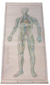 Federation University Historical Collection
Print - Chart, The Circulatory System, 1952
... Chart...This chart was used in the School of Mines Ballarat science laboratory until it was removed in 2015....This large paper on linen chart depicts a coloured diagram of the internal circulatory system of person....The Circulatory System Print Chart Ernst Klett Verlag ...This chart was used in the School of Mines Ballarat science laboratory until it was removed in 2015.This large paper on linen chart depicts a coloured diagram of the internal circulatory system of person.the circulatory system, biology, ballarat school of mines, science laboratory, medical, body, circulation, education material -
 Yarra Ranges Regional Museum
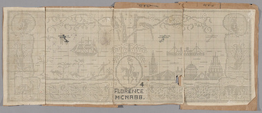
Pamphlet - Pattern, Crochet, Mary Cards Victorian Centenary Chart, 1934
... Mary Cards Victorian Centenary Chart ...This crochet chart was designed by the twentieth century crochet pattern designer, Mary Card, for the Victorian Centenary in 1934. ...Chart has FLORENCE / MCNABB 1944 written in pen ar thje bottom. ...Mary Cards Victorian Centenary Chart Pamphlet Pattern, Crochet ...This crochet chart was designed by the twentieth century crochet pattern designer, Mary Card, for the Victorian Centenary in 1934. It was published in the Australian Home Beautiful magazine on November 1934. The chart was published in four sections, with instructions for working it as a complete piece. Mary Card lived in Olinda and published books of her patterns and individual patterns in Australia, American and English magazines from 1909 until the 1930s.Giant paper crochet chart of Mary Cards Victorian Centenary cloth design, featuring Australian animals, ships, buildings and horseman. Chart has FLORENCE / MCNABB 1944 written in pen ar thje bottom. Over the orignial pattern which was printed with VICTORIAN / CENTENARY 1934. Chart is in 4 pieces, each attached to Cardboard. Written on with ink: 12-4-44 On back : No 1, No 2 , No 3, No 4 mary card, centenaries, crochet patterns -
 Lara RSL Sub Branch
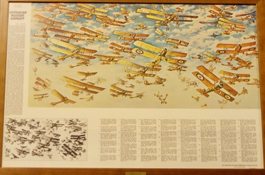
Print in Wooden Frame, Australian Military Aircraft 1909 - 1918
... Picture of Australian Military Aircraft 1909 to 1918 The First chart in the 6 part series reproducing the War Memorial mural painted by Harold Freedman. ...Donated by Pedro Pegan in 2015 Chart 1 Australian War Memorial...Lara RSL Sub Branch McClelland Ave Lara Picture of Australian Military Aircraft 1909 to 1918 The First chart in the 6 part series reproducing the War Memorial mural painted by Harold Freedman. ...Picture of Australian Military Aircraft 1909 to 1918 The First chart in the 6 part series reproducing the War Memorial mural painted by Harold Freedman. This concludes the 50th anniversary of the australian Airforce. Print 1 of mural by Harold Freedman depicting Australian Military Aircraft complete with descriptions.Print of vintage aircraft in glass and wooden FrameDonated by Pedro Pegan in 2015 Chart 1 Australian War Memorial -
 Flagstaff Hill Maritime Museum and Village
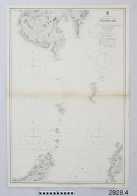
Document - Navigation Chart, Eastern Part of the Celebes Sea, Ca. 1928
... ...chart...This is an Official British Admiralty Navigation Chart, one of a set of 65 charts donated together with a wooden chart case. ...British Admiralty Navigation Chart - Eastern Part of the Celebes Sea - printed on rectangular white paper. ...Flagstaff Hill Maritime Museum and Village 89 Merri Street Warrnambool great-ocean-road This is an Official British Admiralty Navigation Chart, one of a set of 65 charts donated together with a wooden chart case. ...This is an Official British Admiralty Navigation Chart, one of a set of 65 charts donated together with a wooden chart case. It was published and printed in London in 1928 by the British Admiralty. Navigation charts are drawn by professional hydrographers and describe the geography of land and water, enabling a water based navigator on board vessels such as ships to safely negotiate between ports locally and around the world. They are drawn to a particular standard with common symbols noting landmarks. The charts are used in conjunction with other navigational instruments and tools to calculate the vessel’s exact location and a safe route to its destination.The set of charts and their chart are of significance as examples of equipment and documents used to navigate the oceans of the world, particularly to Australia. Migration to Australia is an important part of this country's history.British Admiralty Navigation Chart - Eastern Part of the Celebes Sea - printed on rectangular white paper. Published in London by the British Admiralty in 1928.warrnambool, shipwreck coast, flagstaff hill, flagstaff hill maritime museum, flagstaff hill maritime village, chart, map, navigate, navigation, location, vessel, 1928, british admiralty, hydrographer, geography, admiralty chart, celebes sea -
 National Wool Museum
Chart, Parts of looms made by David Sowden & Sons, loom makers, Shipley
... Chart...Chart: "Parts of looms made by David Sowden & Sons, loom makers, Shipley ", among items from Yarra Falls Mill...Chart: "Parts of looms made by David Sowden & Sons, loom makers, Shipley "....Parts of looms made by David Sowden & Sons, loom makers, Shipley Chart ...Chart: "Parts of looms made by David Sowden & Sons, loom makers, Shipley ", among items from Yarra Falls MillChart: "Parts of looms made by David Sowden & Sons, loom makers, Shipley ".textile machinery weaving, yarra falls mill david sowden & sons, weaving looms, weaving machinery, textile machinery, weaving -
Federation University Historical Collection
Chart, Oxidation-Reduction Half-Reactions in Aqueous Solution, 1962
... Chart...chart...This chart was from the former School of Mines Ballarat science lab and removed in 2015....This large white light card chart is printed in black font and has aluminium edges top and bottom. ...Barker Library (top floor) Mount Helen goldfields This chart was from the former School of Mines Ballarat science lab and removed in 2015. chart oxidation reduction half reactions in aqueous solution ballarat school of mines science laboratory chemistry This large white light card chart is printed in black font and has aluminium edges top and bottom. ...This chart was from the former School of Mines Ballarat science lab and removed in 2015.This large white light card chart is printed in black font and has aluminium edges top and bottom. chart, oxidation reduction half reactions in aqueous solution, ballarat school of mines, science laboratory, chemistry -
 Royal Australian and New Zealand College of Obstetricians & Gynaecologists (RANZCOG)
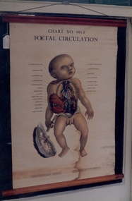
Foetal circulation chart associated with St George's Hospital, Kew, Adam, Rouilly and Co, c1947
... This chart was used in the antenatal classes and labour ward of St Georges Hospital, Kew. ...A chart depicting foetal circulation in an infant male. ...Infant care A chart depicting foetal circulation in an infant male. ...This chart was used in the antenatal classes and labour ward of St Georges Hospital, Kew. The original drawings for the chart by WJ Pardoe were made under the supervision of Assistant Professor CFV Smout, Department of Anatomy, Birmingham University 1945.A chart depicting foetal circulation in an infant male. The chart is made of paper with cloth backing and is supported by wooden hanging bars at top and bottom. Blue and wdhite hanging string is secured at the top with metal eye hooks. The char is secured at the top with metal tacks and there is a cotton tape to secure it when rolled. infant care -
 The Beechworth Burke Museum
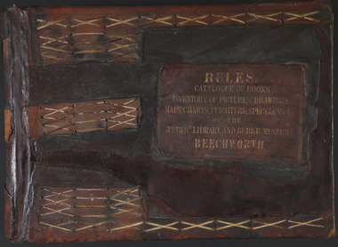
Book - 1875 Catalogue, William Detmold, RULES / CATALOGUE OF BOOKS / INVENTORY OF PICTURES, DRAWINGS, / MAPS, CHARTS, FURNITURE, SPECIMENS / OF THE / PUBLIC LIBRARY AND BURKE MUSEUM / BEECHWORTH, 1875
... As well as artworks, charts, photographs, machinery, maps etc., all of which have been held in the museum since. ...Inside is a comprehensive and detailed itemised listing of the paintings, drawings, charts, photographs, specimens and books that entered the institution from 1850 -1882. ...Cover: RULES / CATALOGUE OF BOOKS / INVENTORY OF PICTURES, DRAWINGS, / MAPS, CHARTS, FURNITURE, SPECIMENS / OF THE / PUBLIC LIBRARY AND BURKE MUSEUM / BEECHWORTH...As well as artworks, charts, photographs, machinery, maps etc., all of which have been held in the museum since. ...This large, leather bound journal was made for the Public Library and Burke Museum in Beechworth by book manufacturer, William Detmold in 1875. It was commissioned by the President of the Library and Burke Museum committee, Dr Antoine Mousse, for the purpose of cataloguing all the items in the collection. The cataloguer was the curator at that time, William Morton, whose hand-writing appears in the journal today. When William Morton first started recording in this journal in 1875, there were already a number of existing items in the institution. The Public Library and Burke Museum in Beechworth had actually been operating since the 1850s; first as a Young Men’s Association in 1856, then as Beechworth Athenaeum in 1858, then as the Beechworth Public Library in 1860. Then in 1861 when news of the death of Beechworth’s former police superintended, Robert O’Hara Burke, reached the town, it was agreed that the Public Library would also become a museum to tribute his legacy, renaming it as the ‘Public Library and Robert O’Hara Burke Memorial Museum, Beechworth’. Many of the items from the early institutions would have been used to form the nucleus of this new organisation. Plus, the additional items that were either collected or donated to develop it into a museum. The catalogue is extensive. There are exactly 461 pages of recorded items, each page detailing the various collections the museum acquired in the late 19th century. Collections recorded in this catalogue include a large collection of geological specimens, that were given to the museum in 1868 by the Geological Survey Department of Victoria. A large collection of taxidermy mounts, that were given to the museum as skins by the Museum of Australia in 1865. An extensive collection of Aboriginal artefacts that were purchased from amateur anthropologist R. E . Johns in 1868. As well as artworks, charts, photographs, machinery, maps etc., all of which have been held in the museum since. This catalogue also details the governance and management of the organisation. There were originally 30 rules that governed the actions for the management committee and, while anyone could read in the free library, only subscribers could borrow two books and one periodical. At first, subscriptions rates were 7/6 a quarter. This was later changed to £1 per annum, paid quarterly in advance. This was a considerable amount; 7/6 per quarter meant that the annual fee was £1.10. This was equivalent to about £650.00 or about $1,182.00AUD today, while the reduced subscription fee of £1 a year was the equivalent to £450.00 or about $818.00AUD today. Membership of the athenaeum would have been the reserve of the town's notable citizens. The vale of the catalogue lies not only in its historical connect with the establishment of the Athenaeum and the current museum, but also in its record of the names and positions of all members of the institution's committees of management from 1875-1876. This is a unique object that contains important records for a notable country town. Large brown leather bound book made in 1875 for the Beechworth library and museum by William Detmond. Inside is a comprehensive and detailed itemised listing of the paintings, drawings, charts, photographs, specimens and books that entered the institution from 1850 -1882. non-fictionCover: RULES / CATALOGUE OF BOOKS / INVENTORY OF PICTURES, DRAWINGS, / MAPS, CHARTS, FURNITURE, SPECIMENS / OF THE / PUBLIC LIBRARY AND BURKE MUSEUM / BEECHWORTHburke museum, beechworth, catalogue, museum catalogue, 1875, william morton, william detmold, exposition universelle, ferdinand von mueller, public library, collection, book, leather bound, restored, digitised, robert o'hara burke, hand-written