Showing 104 items matching "contour map"
-
 Federation University Historical Collection
Program, Booklet, Newspaper Cuttings, Map, Mount Lyell Contour Map
... Mount Lyell Contour Map......contour map...Copy of a contour map of Mount Lyell, Tasmania, showing the mining areas of West Lyell, Glen Lyell. ...mount lyell tasmania contour map Copy of a contour map of Mount Lyell, Tasmania, showing the mining areas of West Lyell, Glen Lyell. ...Copy of a contour map of Mount Lyell, Tasmania, showing the mining areas of West Lyell, Glen Lyell. Gormanston, Cape Horn and Comstock.mount lyell, tasmania, contour map -
 Surrey Hills Historical Society Collection
Map, Contour map of Surrey Hills showing potential sites for the Telecom Tower
... Contour map of Surrey Hills showing potential sites for the Telecom Tower...contour map...Two A3 photocopied sheets of a map showing part of Surrey Hills, roughly between Windsor Crescent and Belmont Street (north / south) and Standard Avenue and Balmoral Crescent (east / west). The map shows contour lines and house sites, 16 of which are numbered. ..."Contour map of potential sites / for the telecommunications tower which / was eventually sited at 2. / Jock Campbell OBE was our neighbour / at 4 Theodore St when we moved into / the area in 1984. ...The location is said to be the second highest site in Melbourne, sometimes described as Delaney's Hill. contour map Telecom tower maps Jock Campbell John Duncan Campbell "Contour map of potential sites / for the telecommunications tower which / was eventually sited at 2. / Jock Campbell OBE was our neighbour / at 4 Theodore St when we moved into / the area in 1984. ...The PMG / Telecom / Telstra tower was built in 1961-1963 as a relay station to support television and radio links between city and regional broadcasting stations. The tower itself was 45 m in height with a 2 storey building for equipment and staff surrounded by garden. From the beginning it was opposed by local residents. The location is said to be the second highest site in Melbourne, sometimes described as Delaney's Hill.Two A3 photocopied sheets of a map showing part of Surrey Hills, roughly between Windsor Crescent and Belmont Street (north / south) and Standard Avenue and Balmoral Crescent (east / west). The map shows contour lines and house sites, 16 of which are numbered. One sheet has been inscribed in top RH corner with notes regarding the significance of the numbers."Contour map of potential sites / for the telecommunications tower which / was eventually sited at 2. / Jock Campbell OBE was our neighbour / at 4 Theodore St when we moved into / the area in 1984. He was responsible in his / job at the PMG in deciding on the /site of the tower - Note site 5 was / behind his (& our) house. / Jack ended his career as Deputy Director / of the PMG. He sat on international committees / after WW2 to decide the split of the electronic / spectrum for radio, TV etc. / His group developed a "mobile phone" using / fixed towers but the phone was a truck full of gear."contour map, telecom tower, maps, jock campbell, john duncan campbell -
University of Melbourne, Burnley Campus Archives
Plan - Photocopy, Contour Map 1891, 1891
... Contour Map 1891..."Contour map 1891" written in biro...From Central Plan Office Dept. of Natural Resources. Contour Map 1891 Plan Photocopy ...Photocopy of plan showing contour lines from Yarra River. Shows Pavilion and Principal's Residence but not much of the garden design. From Central Plan Office Dept. of Natural Resources."Contour map 1891" written in biroyarra river, pavilion, burnley horticultural college, burnley gardens -
 National Vietnam Veterans Museum (NVVM)
Map, A Contour Map of South Vietnam
... A Contour Map of South Vietnam....A contour map showing ATF Base Patrols....National Vietnam Veterans Museum (NVVM) 25 Veterans Drive Newhaven phillip-island-and-the-bass-coast ATF Base Patrols A contour map showing ATF Base Patrols. A Contour Map of South Vietnam. ...A contour map showing ATF Base Patrols.atf base patrols -
Moorabbin Air Museum
Drawing (item) - Contour map Korumburra area Contour map Sorrento, Miscellaneous Aircraft Drawings
... Contour map Korumburra area Contour map Sorrento ...Moorabbin Air Museum Moorabbin Airport 12 First Street Moorabbin melbourne Miscellaneous Aircraft Drawings Drawing Contour map Korumburra area Contour map Sorrento ... -
 Creswick Campus Historical Collection - University of Melbourne
Map - Contour map of the School of Forestry Creswick, 1999, School of Forestry Creswick Existing Conditions Plan
... Contour map of the School of Forestry Creswick, 1999...Creswick Campus Historical Collection - University of Melbourne 4 Water Street University of Melbourne Creswick Campus Building 719/718 Creswick goldfields School of Forestry Creswick Existing Conditions Plan, Kevyn Joy Architects, Scale, 1:500, Jan 1999, Drawing No: 1035A Architectural paper plan of the School of Forestry School of Forestry Creswick Existing Conditions Plan Map Contour map of the School of Forestry Creswick, 1999 ...Architectural paper plan of the School of ForestrySchool of Forestry Creswick Existing Conditions Plan, Kevyn Joy Architects, Scale, 1:500, Jan 1999, Drawing No: 1035A -
Broadmeadows Historical Society & Museum
Map - Map of Australia, John Bartholomew & Son Ltd, Contour- coloured world map series: Australia, c. 1955
... Contour- coloured world map series: Australia...Map of Australia - Colour contoured - printed on cloth, scale 1:5,000,000...Broadmeadows Historical Society & Museum 21 Pearcedale Parade Broadmeadows melbourne Printed 1955 Quality Map in good condition, can be used for research purposes Australia Map Historical information Education Map of Australia - Colour contoured - printed on cloth, scale 1:5,000,000 Contour- coloured world map series: Australia Map Map of Australia John Bartholomew & Son Ltd Mr. ...Printed 1955Quality Map in good condition, can be used for research purposesMap of Australia - Colour contoured - printed on cloth, scale 1:5,000,000australia, map, historical information, education -
 Federation University Historical Collection
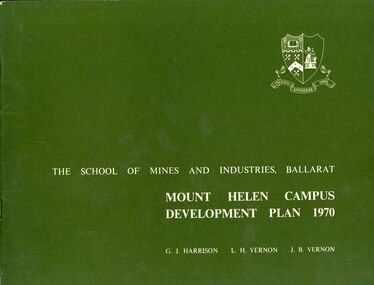
Book, Mount Helen campus Development Plan 1970, 1970
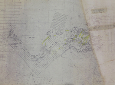
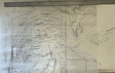
... ...contour map...It was proposed that the trees present on the site should not be removed until development plans have been studied in greater detail, with an early step being to reinforce existing material with suitable broad-scale planting, mainly of native species, such as selected eucalyptus and wattles, to give broad coherence between the various element on the site and to define its boundaries. university of ballarat ballarat institute of advanced education mount helen master plan landscape harrison vernon great hall geoff harrison john vernon m.b. john contour map student accomodation landscaping development plan campus plan Green and white soft covered booklet of 48 pages. ...Green and white soft covered booklet of 48 pages. SMB Crest is on the front cover. The content include the Mt Helen site, site planning, student residences, sporting facilities, roads and parking, pedestrian circulation, engineering services, and landscaping. Illustrations include: Plan of Mt Helen Site (July 1969, existing buildings, Functional relationship, Roads and Parking, Pedestrian Circulation, engineering Services, Landscaping, Development Plan, Plan of Academic area, Library and union Courtyards, Birds Eye View of Academic Area from north-west, etc. the master plan projects student numbers.non-fictionuniversity of ballarat, ballarat institute of advanced education, mount helen, master plan, landscape, harrison, vernon, great hall, geoff harrison, john vernon, m.b. john, contour map, student accomodation, landscaping, development plan, campus plan -
 Federation University Historical Collection
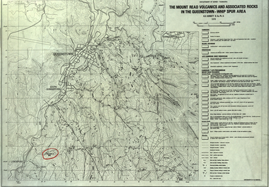
Map, The Mount Read Volcanics and Associated Rocks in the Queenstown - Whip Spur Area, 1978, 1978
... Contour map of the Queenstown area in Tasmania, Australia....department of mines tasmania volcanics mount read queesntown whip spur mining king river gormanston mt owen lynchford Contour map of the Queenstown area in Tasmania, Australia. ...Contour map of the Queenstown area in Tasmania, Australia.department of mines tasmania, volcanics, mount read, queesntown, whip spur, mining, king river, gormanston, mt owen, lynchford -
 Bendigo Military Museum
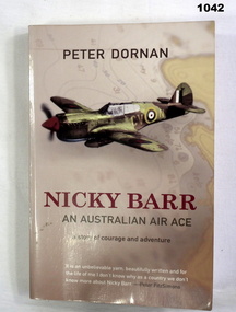
Book, Nicky Barr. An Australian Air Ace, 2005
... Front cover has drawing of a fighter plane with a contour map in background. Back cover has two fighter planes. ...Front cover has drawing of a fighter plane with a contour map in background. Back cover has two fighter planes. ...Light brown soft cover. Front cover has drawing of a fighter plane with a contour map in background. Back cover has two fighter planes. Author - PETER DORAN Pages 282 Written on front page. "Donated by BGO YMCA" books-military-air force, military history -
 Bendigo Military Museum
Map - MAP, RAVENSWOOD, VIC TRAINING AREA, Aust Army, Unknown
... This is an enlarged version of a contour map. It is undated. On centre left is Ravenswood Train station. ...This is an enlarged version of a contour map. It is undated. On centre left is Ravenswood Train station. ...Items in the collection re Lt Col J. Swatton, refer Cat No 6719.2P for his service details.This is an enlarged version of a contour map. It is undated. On centre left is Ravenswood Train station. The Calder Highway is shown, from the bottom of the map to halfway up left side. Top right side shows "Spring Hill".Each grid square is 1000 x 1000 yards. Top right corner grid is 230,000 E, 450,000 Nth. Magnetic variation when this map was made is 6.55' grid to magnetic Nth. printed onto the map, with an "X" are 'Starting Point', "Debussing Point", and "Assembly Point" . Handwritten in red pencil at top LHS are the letters "C.O".passchendaele barracks trust, map, j.w. swatton -
 Creswick Campus Historical Collection - University of Melbourne
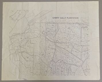
Map - Sawpit Gully Plantation showing plantation lots up to 1976, Sawpit Gully Plantation W.B.P No. 304
... Printed map, contours at 25 ft....Creswick Campus Historical Collection - University of Melbourne 4 Water Street University of Melbourne Creswick Campus Building 719/718 Creswick goldfields Printed map, contours at 25 ft. Sawpit Gully Plantation W.B.P No. 304 Map Sawpit Gully Plantation showing plantation lots up to 1976 ...Printed map, contours at 25 ft. -
 B-24 Liberator Memorial Restoration Australia Inc
Map - US World War II-coloured map, - Southwest Pacific Area, No.22 Southwestern, No.26 East Java, No.25 Timor, 1943
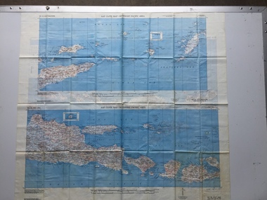
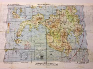
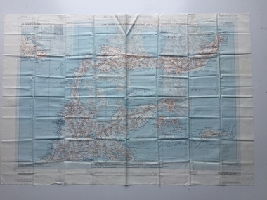
... A multi-coloured, contoured, double-sided map printed on acetate rayon ...This map, printed on acetate rayon, is an original US 'escape and evasion' kit map from World War II. world war ii silk maps united states of america a188 AAF Cloth Map - Southwest Pacific Area Side 1 - No. 22 Southwestern and No. 26 East Java Side 2 - No. 25 Timor A multi-coloured, contoured, double-sided map printed on acetate rayon Map US World War II-coloured map, - Southwest Pacific Area, No.22 Southwestern, No.26 East Java, No.25 Timor ...Silk and rayon maps were produced by the United States (c. 7.5 million in total), Great Britain (some 1.75 million in total) and Australia during World War II. They were issued to Allied military personnel as part of 'escape and evasion' kits.This map, printed on acetate rayon, is an original US 'escape and evasion' kit map from World War II.A multi-coloured, contoured, double-sided map printed on acetate rayon AAF Cloth Map - Southwest Pacific Area Side 1 - No. 22 Southwestern and No. 26 East Java Side 2 - No. 25 Timorworld war ii, silk maps, united states of america, a188 -
 B-24 Liberator Memorial Restoration Australia Inc
Map - US World War II multi-coloured map - Philippine Series, No. C-43 Mindanao Series, No. C-44 North Borneo, 1944
... A multi-coloured, contoured, double-sided map printed on acetate rayon ...This map, printed on acetate rayon, is an original US 'escape and evasion' kit map from World War II. united states of america silk and rayon maps world war ii AAF Cloth Chart - Philippine Series Side 1 - No. C-43 Mindanao Series Side 2 - No. C.44 North Borneo A multi-coloured, contoured, double-sided map printed on acetate rayon Map US World War II multi-coloured map - Philippine Series, No. ...Silk and rayon maps were produced by the United States (c. 7.5 million in total), Great Britain (some 1.75 million in total) and Australia during World War II. They were issued to Allied military personnel as part of 'escape and evasion' kits.This map, printed on acetate rayon, is an original US 'escape and evasion' kit map from World War II.A multi-coloured, contoured, double-sided map printed on acetate rayon AAF Cloth Chart - Philippine Series Side 1 - No. C-43 Mindanao Series Side 2 - No. C.44 North Borneounited states of america, silk and rayon maps, world war ii -
 B-24 Liberator Memorial Restoration Australia Inc
Map - US World War II multi-coloured map, Side 1 - No. C-47 South Borneo, Side 2 - No. C-48 West Java, 1944
... A multi-coloured, contoured, double-sided map printed on acetate rayon ...This map, printed on acetate rayon, is an original US 'escape and evasion' kit map from World War II. united states of america silk and rayon maps world war ii a191 AAF Cloth Chart Side 1 - No. C-47 South Borneo Side 2 - No. C.48 West Java A multi-coloured, contoured, double-sided map printed on acetate rayon Map US World War II multi-coloured map, Side 1 - No. ...Silk and rayon maps were produced by the United States (c. 7.5 million in total), Great Britain (some 1.75 million in total) and Australia during World War II. They were issued to Allied military personnel as part of 'escape and evasion' kits.This map, printed on acetate rayon, is an original US 'escape and evasion' kit map from World War II.A multi-coloured, contoured, double-sided map printed on acetate rayon AAF Cloth Chart Side 1 - No. C-47 South Borneo Side 2 - No. C.48 West Javaunited states of america, silk and rayon maps, world war ii, a191 -
 B-24 Liberator Memorial Restoration Australia Inc
Map - US World War II multi-coloured map- Southwest Pacific Area, No. 23 North Celebes, No. 24 South Celebes, 1942-1943
... A multi-coloured, contoured, double-sided map printed on acetate rayon ...This map, printed on acetate rayon, is an original US 'escape and evasion' kit map from World War II. world war ii silk maps united states of america a189 AAF Cloth Map - Southwest Pacific Area Side 1 - No. 23 North Celebes Side 2 - No. 24 South Celebes A multi-coloured, contoured, double-sided map printed on acetate rayon Map US World War II multi-coloured map- Southwest Pacific Area, No. 23 North Celebes, No. 24 South Celebes ...Silk and rayon maps were produced by the United States (c. 7.5 million in total), Great Britain (some 1.75 million in total) and Australia during World War II. They were issued to Allied military personnel as part of 'escape and evasion' kits.This map, printed on acetate rayon, is an original US 'escape and evasion' kit map from World War II.A multi-coloured, contoured, double-sided map printed on acetate rayon AAF Cloth Map - Southwest Pacific Area Side 1 - No. 23 North Celebes Side 2 - No. 24 South Celebesworld war ii, silk maps, united states of america, a189 -
 Federation University Historical Collection
Photograph - Photograph and Documents, Anne Beggs Sunter, Latta/Downing Family, Mount Helen
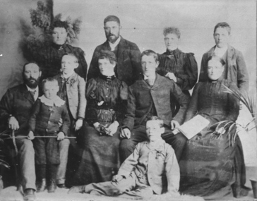
... Davis .2) Part of a 1930s ordinance map showing Ballarat, Buninyong and Greenhill .3) Contour Map with the first two Mt Helen Campus buildings included. .4) Drawing a a proposed campus plan .5) Latta Family negative...Davis .2) Part of a 1930s ordinance map showing Ballarat, Buninyong and Greenhill .3) Contour Map with the first two Mt Helen Campus buildings included. .4) Drawing a a proposed campus plan .5) Latta Family negative Latta/Downing Family, Mount Helen Photograph Photograph and Documents Anne Beggs Sunter ...The Federation University Mt Helen Campus was once the farm of John Latta and his wife Elizabeth Ann Dean. The couple married in 1867 and had three children at the time of John Latta's death (Elizabeth Ann b.1870; Mary b.1873; John b.1875). Elizabeth later married George Downing, and had another six children. The house was situated in the vicinity of the current Administration and Caro Conference Centre buildings, surrounded by an orchard, and a well under the current Albert Coates Building (Union Building). The land was purchased by the Ballarat School of Mines for their tertiary division from the Stapleton family.Various items relating to the Federation University Mount Helen Campus, and the early settlers on the land, the Latta Family. .1) Parish Plan, including E. Latta, M. Fiscalini, R. Wynne, R. Nixon, J.U. Smith, J. Davis .2) Part of a 1930s ordinance map showing Ballarat, Buninyong and Greenhill .3) Contour Map with the first two Mt Helen Campus buildings included. .4) Drawing a a proposed campus plan .5) Latta Family negativemount helen campus, latta family, greenhill, e. latta, m. fiscalini, r. wynne, r. nixon, j.u. smith, j. davis, parish plan, john latta, elizabeth latta, george downing, elezabeth downing, green hill, pontresina, abraham baxter, g. dean, market gardens, jim downing, bob thornton, j. hateley, martin fanning, toll keeper, anne beggs sunter -
 Ringwood and District Historical Society
Map, Photocopied Subdivision Sections of Marlborough Street Heathmont Area, Parish of Ringwood, and accompanying Titles Office correspondence - c.1970
... Plan reference numbers include 51038, 52189 and owners include Nelson Polak and Robert Dyer. Contour map of Dandenong Creek area includes Bellbird Park, Ringwood South Drain, and notation: "Proposed future flood prone line after July 1970 subject to confirmation."...Plan reference numbers include 51038, 52189 and owners include Nelson Polak and Robert Dyer. Contour map of Dandenong Creek area includes Bellbird Park, Ringwood South Drain, and notation: "Proposed future flood prone line after July 1970 subject to confirmation." ...Overlapping taped A4 page sections of low quality photocopied subdivisional map of South-Western area of Heathmont along Dandenong Creek, with handwritten note from Registrar of Titles, Melbourne, to Mrs Hamersley, Down Yonder, Marlborough Road Heathmont 3135."Enclosed please find two copies of the old plan we have been discussing. Some of the details are difficult to read but colour does not reproduce very well in black and white. Regards, Graeme Ross - Plan Section." Plan reference numbers include 51038, 52189 and owners include Nelson Polak and Robert Dyer. Contour map of Dandenong Creek area includes Bellbird Park, Ringwood South Drain, and notation: "Proposed future flood prone line after July 1970 subject to confirmation." -
 B-24 Liberator Memorial Restoration Australia Inc
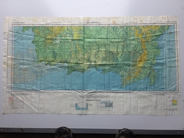
Map - British World War II silk map of Sumatra (South) and Java (Extreme North West), 1944
... A multi-coloured, contoured, double-sided map printed on rayon, 1944 Series South West Pacific Area (SWPA) and Asia ...This map, printed on rayon, is an original British 'escape and evasion' kit map from World War II. world war ii silk maps great britain a187 Sheet G Sumatra (South) and Java (Extreme North West) and, on the reverse, Sheet H Borneo (South West), Java and Sumatra (Extreme South) A multi-coloured, contoured, double-sided map printed on rayon, 1944 Series South West Pacific Area (SWPA) and Asia Map British World War II silk map of Sumatra (South) and Java (Extreme North West) ...Silk and rayon maps were produced by Great Britain (some 1.75 million in total), the United States (c.7.5 million) and Australia during World War II. They were issued to Allied military personnel as part of 'escape and evasion' kits.This map, printed on rayon, is an original British 'escape and evasion' kit map from World War II.A multi-coloured, contoured, double-sided map printed on rayon, 1944 Series South West Pacific Area (SWPA) and Asia Sheet G Sumatra (South) and Java (Extreme North West) and, on the reverse, Sheet H Borneo (South West), Java and Sumatra (Extreme South)world war ii, silk maps, great britain, a187 -
Bendigo Historical Society Inc.
Map - GEOLOGICAL MAP OF BENDIGO GOLD FIELD
... Map of Bendigo gold field showing anticlines, synclines, shaft, alluvial deposits and contour lines. ...History House 11 Mackenzie Street Bendigo goldfields BENDIGO Gold mining geological map Geological Survey Victoria Map of Bendigo gold field showing anticlines, synclines, shaft, alluvial deposits and contour lines. ...Map of Bendigo gold field showing anticlines, synclines, shaft, alluvial deposits and contour lines. Map is in two sections. This map forms part of the Geological Survey of Victoria, Structure of Bendigo Goldfield report, No. 47, 1923. H.Herman, late Director of Geological Survey.Geological Survey Victoriabendigo, gold mining, geological map -
Bendigo Historical Society Inc.
Map - DEBORAH MINE - MAP OF LINES OF REEF AND MINES (BENDIGO)
... Two adjoining photocopies of part of map of Bendigo Goldfield showing lines of reef, mines, streets, locations and contour lines. ...Two adjoining photocopies of part of map of Bendigo Goldfield showing lines of reef, mines, streets, locations and contour lines. ...Two adjoining photocopies of part of map of Bendigo Goldfield showing lines of reef, mines, streets, locations and contour lines. Map is a beige colour with darker lines and letters. Some of the mines have their depths printed beside them. This item is stored in Map drawer 7mine, gold, deborah mine, deborah mine, map of lines of reef and mines (bendigo). -
 Bendigo Military Museum
Administrative record - Geodetic Survey and Topographical Mapping in Australia - Report by BP Lambert 1968, 1968
... Over the intervening period there has been an urgent and increasing demand for topographic maps varying from large scale contoured maps in support of specific engineering projects to rapid reconnaissance maps required for mineral prospecting in remote areas. ...Over the intervening period there has been an urgent and increasing demand for topographic maps varying from large scale contoured maps in support of specific engineering projects to rapid reconnaissance maps required for mineral prospecting in remote areas. ...Australia is governed by a Federal Government and by six State Governments. National coordination of their respective geodetic survey and topographic mapping activities is effected on the advice of a National Mapping Council. Twenty years ago, at least 95% of Australia was poorly mapped and what maps existed were in need of revision. only a small area of the continent was covered by horizontal geodetic control and there was no scheme for a national levelling survey. Over the intervening period there has been an urgent and increasing demand for topographic maps varying from large scale contoured maps in support of specific engineering projects to rapid reconnaissance maps required for mineral prospecting in remote areas. Superimposed on this has been a defence requirement, specifically for military training areas, and generally for maps of the whole country. During the period much progress has been made. This paper reports on the progress from early colonial days through to the present time and finally hazards a prediction of future trends.Photocopy of 18-page typed report including diagrams, stapled top left-hand corner. Geodetic Survey and Topographic Mapping a Report by BP Lambert Director of National Mapping, Department of National Development, Canberra, Australia, 1968.royal australian survey corps, rasvy, fortuna, army survey regiment, army svy regt, asr, national mapping -
 Greensborough Historical Society
Map, Australia. Department of Minerals and Energy, Melbourne, topographic map, 1970_
... A topographic map of Victoria with Melbourne as the centre. Provisional edition showing contours in feet. ...Greensborough Historical Society 34A Glenauburn Road Lower Plenty Lower Plenty melbourne A topographic map of Victoria with Melbourne as the centre. Provisional edition showing contours in feet. ...A topographic map of Victoria with Melbourne as the centre. Provisional edition showing contours in feet. International map of the world [scale] 1:1,000,000. Prepared by the Department of Minerals and Energy, Canberra in 1970.A pre-metric map, shows the Hume Highway travelling through towns such as Seymour and Benalla, now by-passed by the Hume Freeway.Map, printed in colour on one side.victoria - maps -
 Ringwood and District Historical Society
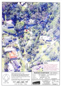
Document, Proposed Subdivision 5-7 Homebush Court Ringwood East 3135 - 20/7/2005
... Three coloured overhead view maps showing contours and proposed property boundaries with varied common property access references (Ref 12506T1, T2 and T3)...Three coloured overhead view maps showing contours and proposed property boundaries with varied common property access references (Ref 12506T1, T2 and T3) Proposed Subdivision 5-7 Homebush Court Ringwood East 3135 - 20/7/2005 Document ...Three coloured overhead view maps showing contours and proposed property boundaries with varied common property access references (Ref 12506T1, T2 and T3)Notations on each plan: "This plan is a preliminary plan only and is subject to the approval of various statutory authorities. The number and configuration of lots will depend on the precise location of all features and an evaluation of the vegetation by a qualified arborist." Millar & Merrigan Pty Ltd, Land Development Consultants, 126 Merrindale Drive, Croydon. Telephone (03) 8720 9500, Facsimile (03) 8720 9501. Email [email protected], PO Box 247 Croydon Vic 3136. -
 Bendigo Military Museum
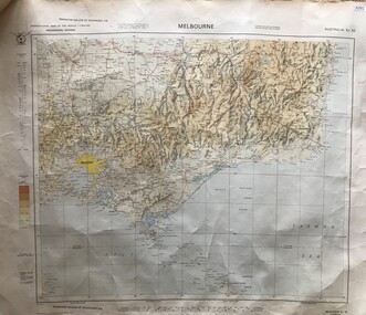
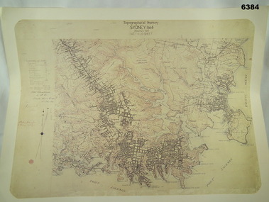
Map - Australian Topographical Survey SYDNEY / 56III Southern Half, NE Plane Table Field sheet 1915, Australian Survey Corps, 6 Dec 1915
... Also of interest is the fact that this field sheet that was used to create the actual SYDNEY map sheet was contoured, many map sheets produced up until now were purely planimetric and lacked contouring that was needed for military use. ...Also of interest is the fact that this field sheet that was used to create the actual SYDNEY map sheet was contoured, many map sheets produced up until now were purely planimetric and lacked contouring that was needed for military use. ...This is a unique example of a hand drawn plane table sheet produced in the first year of the Australian Survey Corps by original members of the Corps. Roseblade and Lynch 5 Dec 1915. Of interest is the documented times that it took to create the original field sheet. Also of interest is the fact that this field sheet that was used to create the actual SYDNEY map sheet was contoured, many map sheets produced up until now were purely planimetric and lacked contouring that was needed for military use. This is a reproduction print of a photograph of the original field sheet and was printed at the Army Survey Regiment, Bendigo.Reprinted coloured Image of Australian Topographical Survey SYDNEY /56 III Southern Half, hand drawn NE Plane Table field sheet. Includes an itemized summary of work performed by HA Roseblade CSM Australian Survey Corps 1915, Signed by J Lynch Lieutenant.royal australian survey corps, rasvy, fortuna, army survey regiment, army svy regt, asr -
 Bendigo Military Museum
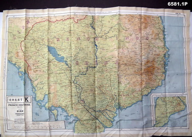
Photograph - Photograph of a silk map of Indo China, Circa 1939
... The map has contours (heights) and legend panel information. ...The map has contours (heights) and legend panel information. ...Silk maps were produced as "Escape Maps" as they were easily folded and compressed to carry. They were often sewn into the jackets of aircraft pilots..1P Photograph of a Silk map of Indo China Map No 44K covering Siam (Thailand) and part of Vietnam and Cambodia at a scale of 1:1million. The map has contours (heights) and legend panel information. .2P Photograph of the reverse side of a Silk map of Indo China Map No 44J covering Siam (Thailand) at a scale of 1:1million. The map has contours (heights) and legend panel information. royal australian survey corps, rasvy, fortuna, army survey regiment, army svy regt -
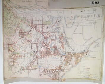 Bendigo Military Museum
Map - Map of Newcastle NSW 4 Inch - 1 Mile 1910, Australian Intelligence Corps, Nov 1910
... They were aiming at producing eight map sheets per year covering about 7,000 square miles (18,000 square Km) This map sheet of the Newcastle area was produced using plane table methods and was surveyed and hand drawn by LCPL A Barrett Oct - Nov 2010. It was unique because it was now produced on an accurate gridded base and included contouring. ...A gridded Map of Newcastle NSW area scale four inches to one mile with 25 feet interval contouring. ...Royal Australian Survey Corps RASvy Fortuna Army Svy Regt Army Survey Regiment Signed by " A Barrett LCPL Royal Engineers" A gridded Map of Newcastle NSW area scale four inches to one mile with 25 feet interval contouring. ...In 1909 the Australian Army Headquarters realized that mapping in Australia was either non existent or inadequate for Military use. It was requested that Australia borrow Survey personnel from the UK Royal Engineers (RE) for a two-year detachment. On 11 April 1910 four RE NCOs arrived in Melbourne comprising CPL J Lynch, and LCPLs AH Barrett, EF Davies and R Wilcox. LCPL Barrett had 12yrs experience with RE. They were aiming at producing eight map sheets per year covering about 7,000 square miles (18,000 square Km) This map sheet of the Newcastle area was produced using plane table methods and was surveyed and hand drawn by LCPL A Barrett Oct - Nov 2010. It was unique because it was now produced on an accurate gridded base and included contouring. Lynch and Davies transferred to the Royal Australian Engineers (RAE) whilst Barrett and Wilcox returned to the UK in June 1913. Barrett returned to Australia in 1915 and also enlisted in the RAE and served until 1919.A gridded Map of Newcastle NSW area scale four inches to one mile with 25 feet interval contouring. Coloured hand drawn map produced in 1910. Signed by " A Barrett LCPL Royal Engineers"royal australian survey corps, rasvy, fortuna, army svy regt, army survey regiment -
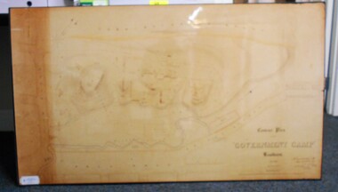 Bendigo Historical Society Inc.
Map - CONTOUR PLAN OF THE GOVERNMENT CAMP SANDHURST 1854, 1994
... Contour map (copy) of the Government Camp Sandhurst, 1854. ...Sandhurst Bendigo. Contour map (copy) of the Government Camp Sandhurst, 1854. ...Contour map (copy) of the Government Camp Sandhurst, 1854. Map is mounted on coreflute and laminated. Written in bottom righthand corner 'Contour Plan of the Government Camp, Sandhurst. Dec 1854. Signed by Richard Larritt, Assistant Surveyor, 11th December 1854.' Shown on map: Pall Mall, Bendigo Creek, Commissioner's Gully, View Place (now View Street), Post Office, Bank of Victoria, District Surgeon, Sandhurst Fire Brigade, Police Hospital, Flagstaff, Gold Office, License Shed, Military Barracks, Stables, Commissioner's Buildings, Police Office. Old Cemetery, Garden. Reference on righthand side: 'Stone or brick buildings are tinted in crimson. Wooden buildings tinted in Indian Ink. Tents and other temporary structures tinted in Burnt Sienna.' Scale of Chains, on bottom of map. Sticker on bottom left hand corner and back of map ' Presented by Survey and Mapping, Victoria, 7th Octber, 1994'.map, bendigo, government camp, pall mall, bendigo creek, commissioner's gully, view place (now view street), post office, bank of victoria, district surgeon, sandhurst fire brigade, police hospital, flagstaff, gold office, license shed, military barracks, stables, commissioner's buildings, police office. old cemetery, garden. , survey and mapping victoria. sandhurst, bendigo. -
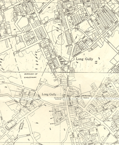 Bendigo Historical Society Inc.
Map - LONG GULLY HISTORY GROUP COLLECTION: MAP OF LONG GULLY AREA
... Map shows Eaglehawk Road from Don Street to Weatherall Street, then Mt Korong Road to Dowding Street. Some contour...Map shows Eaglehawk Road from Don Street to Weatherall Street, then Mt Korong Road to Dowding Street. Some contour ...BHS CollectionMap of Long Gully area printed on yellow paper. Map shows Eaglehawk Road from Don Street to Weatherall Street, then Mt Korong Road to Dowding Street. Some contour lines on the map.bendigo, history, long gully history group, the long gully history group - map of long gully area, borough of eaglehawk -
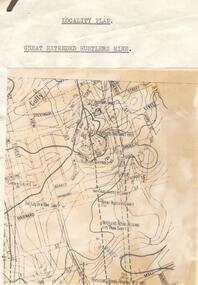 Bendigo Historical Society Inc.
Map - GREAT EXTENDED HUSTLERS MINE - LOCALITY MAP OF GREAT EXTENDED HUSTLERS MINE
... Location map showing the Hustlers line of mines. Map has contours with heights. Mines are named and most of them have the depth printed beside the name. ...Great Extended Hustlers Mine Locality Map of Great Extended Hustlers Mine Great Extended Hustlers Trib Shaft Hustlers Extended Imperial Hustlers Shaft Royal Hustlers Shaft Hustlers Royal Reserve Park Shaft Hustlers Royal Reserve No 2 Garden Gully E Shaft The Golden One Shaft Location map showing the Hustlers line of mines. Map has contours with heights. Mines are named and most of them have the depth printed beside the name. ...Location map showing the Hustlers line of mines. Map has contours with heights. Mines are named and most of them have the depth printed beside the name. Street names are also included. Map is pasted onto a larger piece of paper.mine, gold, great extended hustlers., great extended hustlers mine, locality map of great extended hustlers mine, great extended hustlers trib shaft, hustlers extended, imperial hustlers shaft, royal hustlers shaft, hustlers royal reserve park shaft, hustlers royal reserve no 2, garden gully e shaft, the golden one shaft