Showing 1917 items matching "county"
-
 Eltham District Historical Society Inc
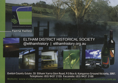
Postcard - Photograph, Evelyn County Estate, Evelyn County Estate, Yarra Valley, c.2009
... Evelyn County Estate, Yarra Valley...Evelyn County Estate...Eltham District Historical Society Inc 728 Main Rd Eltham melbourne The Evelyn Country Estate, Cellar Door and Black Paddock restaurant and Tony Smibert Gallery opened on 26 April 2001 and officially opened on 18 May 2001 by Roger and Robyn Male - KGC Winter 2001 Evelyn County Estate Kangaroo Ground Postcard Yarra Valley restaurant Postcard 10.5 x 14.8 cm Evelyn County Estate, Yarra Valley Postcard Photograph Evelyn County Estate ...The Evelyn Country Estate, Cellar Door and Black Paddock restaurant and Tony Smibert Gallery opened on 26 April 2001 and officially opened on 18 May 2001 by Roger and Robyn Male - KGC Winter 2001evelyn county estate, kangaroo ground, postcard, yarra valley, restaurant -
 Eltham District Historical Society Inc
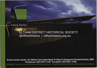
Postcard - Photograph, Evelyn County Estate, Evelyn County Estate, Yarra Valley, c.2009
... Evelyn County Estate, Yarra Valley...Evelyn County Estate...Eltham District Historical Society Inc 728 Main Rd Eltham melbourne The Evelyn Country Estate, Cellar Door and Black Paddock restaurant and Tony Smibert Gallery opened on 26 April 2001 and officially opened on 18 May 2001 by Roger and Robyn Male - KGC Winter 2001 Evelyn County Estate Kangaroo Ground Postcard Yarra Valley restaurant Postcard 10.5 x 14.8 cm Evelyn County Estate, Yarra Valley Postcard Photograph Evelyn County Estate ...The Evelyn Country Estate, Cellar Door and Black Paddock restaurant and Tony Smibert Gallery opened on 26 April 2001 and officially opened on 18 May 2001 by Roger and Robyn Male - KGC Winter 2001evelyn county estate, kangaroo ground, postcard, yarra valley, restaurant -
 Eltham District Historical Society Inc
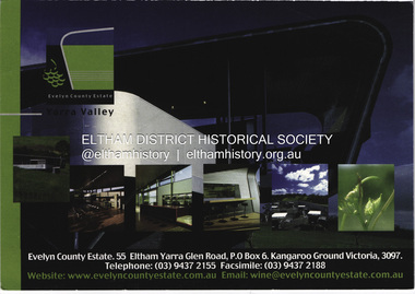
Postcard - Photograph, Evelyn County Estate, Evelyn County Estate, Yarra Valley, c.2009
... Evelyn County Estate, Yarra Valley...Evelyn County Estate...Eltham District Historical Society Inc 728 Main Rd Eltham melbourne The Evelyn Country Estate, Cellar Door and Black Paddock restaurant and Tony Smibert Gallery opened on 26 April 2001 and officially opened on 18 May 2001 by Roger and Robyn Male - KGC Winter 2001 Evelyn County Estate Kangaroo Ground Postcard Yarra Valley restaurant Postcard 10.5 x 14.8 cm Evelyn County Estate, Yarra Valley Postcard Photograph Evelyn County Estate ...The Evelyn Country Estate, Cellar Door and Black Paddock restaurant and Tony Smibert Gallery opened on 26 April 2001 and officially opened on 18 May 2001 by Roger and Robyn Male - KGC Winter 2001evelyn county estate, kangaroo ground, postcard, yarra valley, restaurant -
 Warrnambool and District Historical Society Inc.
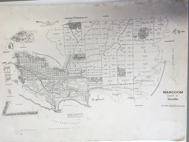
Document: Map, Map Wangoom County of Villiers, 1955
... Map Wangoom County of Villiers... This map contains the names, acreage details and dates of the original property owners of the Parish of Wangoom (County of Villiers), excluding the township of Warrnambool. ...‘Wangoom, County of Villiers’...It is a most valuable research tool and is one of our most-used maps. wangoom warrnambool County of Villiers ‘Wangoom, County of Villiers’ This is a map, printed in black and white and mounted on cardboard. ...This map contains the names, acreage details and dates of the original property owners of the Parish of Wangoom (County of Villiers), excluding the township of Warrnambool. It also has details of the Crown Lands adjoining the Merri and Hopkins Rivers. This is a most important map as it has details on the original property owners. It is a most valuable research tool and is one of our most-used maps.This is a map, printed in black and white and mounted on cardboard. Where there was intensive land ownership the details have been reproduced in larger print on the margins of the map. There are scuff and dirt marks on the map but it is otherwise in good condition.‘Wangoom, County of Villiers’wangoom, warrnambool, county of villiers -
 Flagstaff Hill Maritime Museum and Village
Photograph, late 1800's
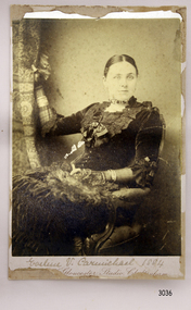
... A printed on the back "County of Gloucester Studio Cheltenham" with the address and other informaion....Reverse has crest that includes “PRIZE MEDALIST PARIS EXHIBIT’N 1867” Printed text “No. …………” “COUNTY OF GLOUCESTER STUDIO / 20a / PROMENADE VILLAS / CHELTENHAM” and “Autotype Prints or Permanent Porcelain enlargements can be made from this plate” ...County of Gloucester Studio...Photograph County of Gloucester Studio ...Miss Eva Carmichael is one of two survivors of the Loch Ard shipwreck.. Loch Ard was bound for Melbourne in 1878 loaded with passengers and cargo when it ran into a rocky reef at the base of Mutton Bird Island, near Port Campbell. Of the 54 crew members and passengers on board, only two survived: an apprentice, Tom Pearce and a young woman passenger, Eva Carmichael, who lost all of her family in the tragedy. The wreck of Loch Ard still lies at the base of Mutton Bird Island and much of the cargo has been salvaged. Some was washed up into what is now known as Loch Ard Gorge following the shipwreck. Cargo and artefacts have also been illegally salvaged over many years before protective legislation was introduced. The photograph is significant for its association with the wreck of the Loch Ard. This wreck has been protected as a Historic Shipwreck since 11 March 1982, under the Commonwealth Historic Shipwrecks Act (1976) Flagstaff Hill’s collection of artefacts from Loch Ard is significant for being one of the largest collections of artefacts from this shipwreck in Victoria. It is significant for its association with the shipwreck, which is on the Victorian Heritage Register. The collection is significant because of the relationship between the objects, as together they have a high potential to interpret the story of the Loch Ard. The Loch Ard collection is archaeologically significant as the remains of a large international passenger and cargo ship. The Loch Ard collection is historically significant for representing aspects of Victoria’s shipping history and its potential to interpret sub-theme 1.5 of Victoria’s Framework of Historical Themes (living with natural processes). The collection is also historically significant for its association with the Loch Ard, which was one of the worst and best known shipwrecks in Victoria’s history. The Loch Ard collection meets the following criteria for assessment: Criterion A: Importance to the course, or pattern, of Victoria’s cultural history. Criterion B: Possession of uncommon, rare or endangered aspects of Victoria’s cultural history. Criterion C: Potential to yield information that will contribute to an understanding of Victoria’s cultural history. Photograph of Miss Eva Carmichael sitting on a chair holding a curtain. Text below photograph is partly unreadable but gives the name of the photographic studio. A printed on the back "County of Gloucester Studio Cheltenham" with the address and other informaion.Reverse has crest that includes “PRIZE MEDALIST PARIS EXHIBIT’N 1867” Printed text “No. …………” “COUNTY OF GLOUCESTER STUDIO / 20a / PROMENADE VILLAS / CHELTENHAM” and “Autotype Prints or Permanent Porcelain enlargements can be made from this plate” flagstaff hill, warrnambool, shipwrecked-coast, flagstaff-hill, flagstaff-hill-maritime-museum, maritime-museum, shipwreck-coast, flagstaff-hill-maritime-village, photograph of miss eva carmichael, eva carmichael, loch ard shipwreck, county of gloucester studio -
 Tatura Irrigation & Wartime Camps Museum
Map, Department of Land and Survey, County of Rodney
... County of Rodney...Early county maps....One original map of County of Rodney and 3 photo copies. Original and one copy in colour. 2 copies in black and white. ...Tatura Irrigation & Wartime Camps Museum 49 Hogan Street Tatura the-murray Early county maps. County of Rodney One original map of County of Rodney and 3 photo copies. ...Early county maps.One original map of County of Rodney and 3 photo copies. Original and one copy in colour. 2 copies in black and white. county of rodney -
 Federation University Historical Collection
Postcard - colour, Enniskerry, County Wicklow, Ireland
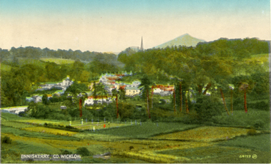
... Enniskerry, County Wicklow, Ireland...Enniskerry, County Wicklow, Ireland...A mountain is evident in the background Enniskerry, County Wicklow, Ireland Postcard - colour ...Possibly acquired because of a connection to rural life and the Irish immigrants settled in the Ballarat District. Harry and Edith Holmes visited this area with my mother, their daughter M. Elizabeth in the early 1950s. [Jane Dyer 2024]A town is surrounded by green fields and trees. A mountain is evident in the backgroundchatham-holmes family collection, enniskerry, wicklow, ireland, postcard -
 Federation University Historical Collection
Postcard - Colour, Kylemore Abbey Connemara, County Galway, Ireland
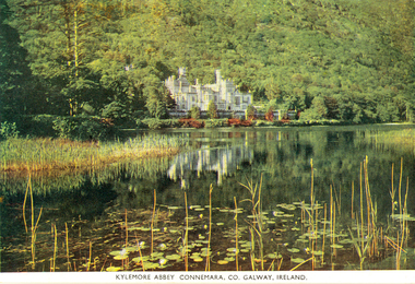
... Kylemore Abbey Connemara, County Galway, Ireland...Connemara, County Galway, Ireland...Kylemore Abbey Connemara, County Galway, Ireland Postcard - Colour ...Possibly acquired because of a connection to rural life and the Irish immigrants settled in the Ballarat District. Harry and Edith Holmes visited this area with my mother, their daughter M. Elizabeth in the early 1950s. [Jane Dyer 2024]An abbey is surrounded by trees with a lake in the foreground.chatham-holmes family collection, kylemore abbey, connemara, galway, ireland -
Whitehorse Historical Society Inc.
Map, Directory Maps of the County of Bourke, 1892
... Directory Maps of the County of Bourke...also a complete map of the Colony of Victoria, showing all the Counties, Parishes, Railways and stations to date, and the Mallee Blocks. ...Directory maps of the County of Bourke, containing all the Parishes ... also a complete map of the Colony of Victoria, showing all the Counties, Parishes, Railways and stations to date, and the Mallee Blocks. ...Scale: 40 chains to the inch. Maps Victoria. County of Bourke T.R.B. Morton & Son Directory maps of the County of Bourke, containing all the Parishes ... ...Directory maps of the County of Bourke, containing all the Parishes ...Directory maps of the County of Bourke, containing all the Parishes ... also a complete map of the Colony of Victoria, showing all the Counties, Parishes, Railways and stations to date, and the Mallee Blocks. Lithographed by G.S.B. Bonney for the Victorian Shire Map Company. Scale: 40 chains to the inch.Directory maps of the County of Bourke, containing all the Parishes ...maps, victoria. county of bourke, t.r.b. morton & son -
 Kew Historical Society Inc
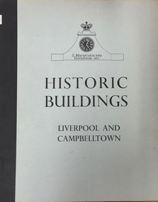
Book, Cumberland County Council, Historic Buildings: Liverpool and Campbelltown, 1963
... [Liverpool, N.S.W.] : Cumberland County Council, 1963 54 p. : ill., maps ; 26 cm. ...Cumberland County Council...Historic Buildings: Liverpool and Campbelltown Book Cumberland County Council Helen Baker ...[Liverpool, N.S.W.] : Cumberland County Council, 1963 54 p. : ill., maps ; 26 cm. non-fictionhistoric buildings -- new south wales -- liverpool., historic buildings -- new south wales -- campbelltown. -
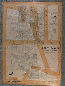
 Emerald Museum & Nobelius Heritage Park
Map - Municipality Road Classification - Beaconsfield-Emerald Rd., Shire of Gembrook 1973, Title Survey Division, Crown Description - Part of Crown Allotment 44, Parish of Gembrook, County of Mornington, c1973
... Title Survey Division, Crown Description - Part of Crown Allotment 44, Parish of Gembrook, County of Mornington...Image of Crown Survey Map for crown allotment 44 (Beaconsfield-Emerald Rd.) parish of Gembrook, County of Mornington...Title Survey Division/Crown Description/Part of Crown Allotment 44, Parish of Gembrook, County of Mornington/Municipality Road Classification, Shire of Berwick, Beaconsfeld-Emerald Rd. ...(MR)/Francis J Webber of Kirkpatrick & Webber, 285 Maroondah Hwy., Ringwood/(Signed) - Principal Title Survey Office 16.1.73/SP13461 Image of Crown Survey Map for crown allotment 44 (Beaconsfield-Emerald Rd.) parish of Gembrook, County of Mornington Title Survey Division, Crown Description - Part of Crown Allotment 44, Parish of Gembrook, County of Mornington Map Municipality Road Classification - Beaconsfield-Emerald Rd., Shire of Gembrook 1973 ...Image of Crown Survey Map for crown allotment 44 (Beaconsfield-Emerald Rd.) parish of Gembrook, County of MorningtonTitle Survey Division/Crown Description/Part of Crown Allotment 44, Parish of Gembrook, County of Mornington/Municipality Road Classification, Shire of Berwick, Beaconsfeld-Emerald Rd. (MR)/Francis J Webber of Kirkpatrick & Webber, 285 Maroondah Hwy., Ringwood/(Signed) - Principal Title Survey Office 16.1.73/SP13461 -
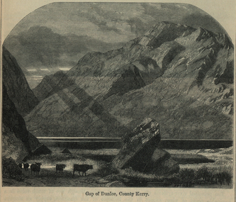 Ballarat and District Irish Association
Image, Gap of Dunloe, County Kerry, c1864
... Gap of Dunloe, County Kerry, c1864...The Gap of Dunloe is a narrow mountain pass between Macgillycuddy's Reeks (west) and Purple Mountain (east) in County Kerry, Ireland. It is about 11 km (6.8 mi) from north to south. ...Image of a mountain range in County Kerry, Ireland. Cattle feature in the foreground. ...(http://en.wikipedia.org/wiki/Gap_of_Dunloe) Ballarat Irish Dunloe Gap of Dunloe County Kerry Image of a mountain range in County Kerry, Ireland. ...The Gap of Dunloe is a narrow mountain pass between Macgillycuddy's Reeks (west) and Purple Mountain (east) in County Kerry, Ireland. It is about 11 km (6.8 mi) from north to south. Within it are five lakes: Coosaun Lough, Black Lake, Cushnavally Lake, Auger Lake, and Black Lough (north to south). These lakes are connected by the River Loe. Between the first two lakes is an old arch bridge called the 'Wishing Bridge' so named because it is said that wishes made while upon it are destined to come true. (http://en.wikipedia.org/wiki/Gap_of_Dunloe)Image of a mountain range in County Kerry, Ireland. Cattle feature in the foreground. ballarat irish, dunloe, gap of dunloe, county kerry -
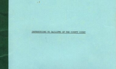 Otway Districts Historical Society
Document, Instructions to Bailiffs of the County Court, 1978, 1 January 1978
... Instructions to Bailiffs of the County Court, 1978....This booklet has been prepared as a guide to Bailiffs of the County Court of Victoria in the performance of their duties. ...Instructions to Bailiffs of the County Court. State of Victorian; Melbourne (Vic); 1978. 28 p. ...Instructions to Bailiffs of the County Court, 1978. Document ...Bailiffs are officers of the Court and as such play an important role in the overall administration of justice. This booklet has been prepared as a guide to Bailiffs of the County Court of Victoria in the performance of their duties. The principal functions of the Bailiffs are the issue and service of summonses, and verdicts and judgements given effect by the execution of warrants. In any case where Bailiffs are uncertain or unsure of what to do the Registrar of the Court to which they are attached should be consulted and their directions followed.Document. Instructions to Bailiffs of the County Court. State of Victorian; Melbourne (Vic); 1978. 28 p. Soft cover.victoria; bailiffs; county court; -
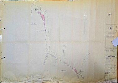
 Ballan Shire Historical Society
Map - Map. Kerrit Bareet, Department of Lands and Survey, Kerrit Bareet. County of Grant, 08/1944
... Kerrit Bareet. County of Grant....A map of the Kerrit Bareet area within the County of Grant showing properties and names of owners in 1944....A map of Kerrit Bareet in the County of Grant. Black printing on buff coloured paper. ...Ballan Shire Historical Society 45-47 Steiglitz St Ballan goldfields A map of the Kerrit Bareet area within the County of Grant showing properties and names of owners in 1944. ...A map of the Kerrit Bareet area within the County of Grant showing properties and names of owners in 1944.Significant to people researching land usage and ownership. Also those researching families in the area at that time.A map of Kerrit Bareet in the County of Grant. Black printing on buff coloured paper. Details roads, rivers, railways, property boundaries and names of property owners and towns and villages. The map is easily readable although there is some physical damage and that and the borders have been reinforced with sellotape. Shows a Scale in Chains and Price 2/.gordon, bungal, kerrit bareet, lal lal, moorarbool river, warrenheip, bungaree, wallace, moorarbool west -
Stawell Historical Society Inc
Map, County of Ripon, 1858
... County of Ripon...County of Ripon...Stawell Historical Society Inc 46 Longfield St Stawell grampians Stawell County of Ripon County of Ripon Map ...County of Riponstawell -
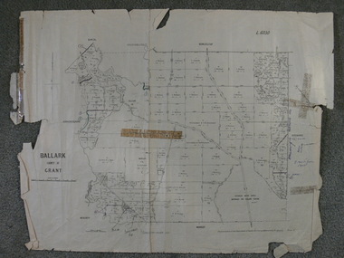 Ballan Shire Historical Society
Map - Map. Ballark, Department of Lands and Survey, Ballark. County of Grant, 31/08/1915
... Ballark. County of Grant...A map of the Ballark area within the County of Grant showing roads, waterways, property boundaries and property owners in 1915....A map of Ballark in the County of Grant. Black printing on buff coloured paper. ...A map of Ballark in the County of Grant. Black printing on buff coloured paper. ...A map of the Ballark area within the County of Grant showing roads, waterways, property boundaries and property owners in 1915.Significant to people researching land usage and ownership. Also those researching families in the area at that time.A map of Ballark in the County of Grant. Black printing on buff coloured paper. Extra notations by hand and various coloured highlighting of certain features. Details roads, rivers, property boundaries and names of property owners and districts. The map is easily readable although there is some physical damage to the borders and some sellotape residue. Shows a scale in Chains and the number L.6030Various numbers and directional arrows added to map.bungal, borhoneyghurk, bungeeltap, ballark, beremboke, moreep, meredith, morrisons, moorarbool river -
Stawell Historical Society Inc
Map, Bellaura, County of Borung, 1880
... Bellaura, County of Borung...Bellaura, County of Borung...Stawell Historical Society Inc 46 Longfield St Stawell grampians Stawell Bellaura, County of Borung Bellaura, County of Borung Map ...Bellaura, County of Borungstawell -
Stawell Historical Society Inc
Map, Bellaura, County of Borung, 1924
... Bellaura, County of Borung...Bellaura, County of Borung...Stawell Historical Society Inc 46 Longfield St Stawell grampians Stawell Bellaura, County of Borung Bellaura, County of Borung Map ...Bellaura, County of Borungstawell -
Stawell Historical Society Inc
Map, Bellellen, County of Borung, 1952
... Bellellen, County of Borung...Bellellen, County of Borung...Stawell Historical Society Inc 46 Longfield St Stawell grampians Stawell Bellellen, County of Borung Bellellen, County of Borung Map ...Bellellen, County of Borungstawell -
Stawell Historical Society Inc
Map, Boroka, County of Borung, 1958
... Boroka, County of Borung ...Boroka, County of Borung ...Stawell Historical Society Inc 46 Longfield St Stawell grampians Stawell Boroka, County of Borung Boroka, County of Borung Map ...Boroka, County of Borung stawell -
Stawell Historical Society Inc
Map, Concongella, County of Borung, 1929
... Concongella, County of Borung...Concongella, County of Borung...Stawell Historical Society Inc 46 Longfield St Stawell grampians Stawell Concongella, County of Borung Concongella, County of Borung Map ...Concongella, County of Borungstawell -
Stawell Historical Society Inc
Map, Gampola, County of Borung, 1957
... Gampola, County of Borung...Gampola, County of Borung...Stawell Historical Society Inc 46 Longfield St Stawell grampians Stawell Gampola, County of Borung Gampola, County of Borung Map ...Gampola, County of Borungstawell -
Stawell Historical Society Inc
Map, Glenorchy, County of Borung, 1956
... Glenorchy, County of Borung...Glenorchy, County of Borung...Stawell Historical Society Inc 46 Longfield St Stawell grampians Stawell Glenorchy, County of Borung Glenorchy, County of Borung Map ...Glenorchy, County of Borungstawell -
Stawell Historical Society Inc
Map, Illawarra, County of Borung, 1882
... Illawarra, County of Borung...Illawarra, County of Borung...Stawell Historical Society Inc 46 Longfield St Stawell grampians Stawell Illawarra, County of Borung Illawarra, County of Borung Map ...Illawarra, County of Borungstawell -
Stawell Historical Society Inc
Map, Illawarra, County of Borung, 1955
... Illawarra, County of Borung...Illawarra, County of Borung...Stawell Historical Society Inc 46 Longfield St Stawell grampians Stawell Illawarra, County of Borung Illawarra, County of Borung Map ...Illawarra, County of Borungstawell -
Stawell Historical Society Inc
Map, Kirkella, County of Borung, 1957
... Kirkella, County of Borung...Kirkella, County of Borung...Stawell Historical Society Inc 46 Longfield St Stawell grampians Stawell Kirkella, County of Borung Kirkella, County of Borung Map ...Kirkella, County of Borungstawell -
Stawell Historical Society Inc
Map, Moyston, County of Borung, 1951
... Moyston, County of Borung...Moyston, County of Borung...Stawell Historical Society Inc 46 Longfield St Stawell grampians Stawell Moyston, County of Borung Moyston, County of Borung Map ...Moyston, County of Borungstawell -
Stawell Historical Society Inc
Map, Jallukar, County of Borung, 1971
... Jallukar, County of Borung...Jallukar, County of Borung...Stawell Historical Society Inc 46 Longfield St Stawell grampians Stawell Jallukar, County of Borung Jallukar, County of Borung Map ...Jallukar, County of Borungstawell -
Stawell Historical Society Inc
Map, Stawell, County of Borung, 1959
... Stawell, County of Borung...Stawell, County of Borung...Stawell Historical Society Inc 46 Longfield St Stawell grampians Stawell Stawell, County of Borung Stawell, County of Borung Map ...Stawell, County of Borungstawell -
Stawell Historical Society Inc
Map, William, County of Borung, Shire of Stawell, 1945
... William, County of Borung, Shire of Stawell...William, County of Borung...Stawell Historical Society Inc 46 Longfield St Stawell grampians Stawell William, County of Borung William, County of Borung, Shire of Stawell Map ...William, County of Borungstawell