Showing 165 items matching "department of crown lands"
-
 Bayside Gallery - Bayside City Council Art & Heritage Collection
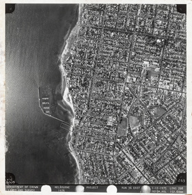
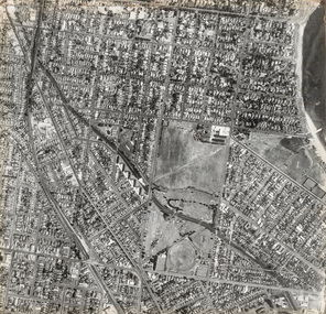
Photograph, Department of Crown Lands and Survey, Victoria, Melbourne Project: Brighton, 1976
... ...Department of Crown Lands and Survey...The Department of Crown Lands and Survey (1857-1983) was responsible for the administration of survey and mapping and the sale, occupation and management of crown land throughout its existence. ...Department of Crown Lands and Survey, Victoria...Melbourne Project: Brighton Photograph photograph Department of Crown Lands and Survey, Victoria ...The Department of Crown Lands and Survey (1857-1983) was responsible for the administration of survey and mapping and the sale, occupation and management of crown land throughout its existence. This aerial photograph shows parts of Brighton and was taken on 1 December 1976brighton, department of crown lands and survey, aerial photograph, bayside, port phillip bay, map, cartographic material, melbourne project 1976, brighton yacht club, middle brighton baths, north road, st kilda street, new street -
 Bayside Gallery - Bayside City Council Art & Heritage Collection
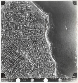
Photograph, Department of Crown Lands and Survey, Victoria, Melbourne Project: Brighton and Elwood, 1976
... ...Department of Crown Lands and Survey...The Department of Crown Lands and Survey (1857-1983) was responsible for the administration of survey and mapping and the sale, occupation and management of crown land throughout its existence. ...Department of Crown Lands and Survey, Victoria...Melbourne Project: Brighton and Elwood Photograph photograph Department of Crown Lands and Survey, Victoria ...The Department of Crown Lands and Survey (1857-1983) was responsible for the administration of survey and mapping and the sale, occupation and management of crown land throughout its existence. This aerial photograph shows parts of Brighton and Elwood and was taken on 1 December 1976brighton, elwood, department of crown lands and survey, aerial photograph, elsternwick park, point ormond, north road, ormond esplanade, st kilda street, glen huntly road, bayside, port phillip bay, map, cartographic material, melbourne project 1976 -
 Bayside Gallery - Bayside City Council Art & Heritage Collection
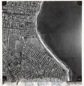
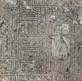
Photograph, Department of Crown Lands and Survey, Victoria, Melbourne Project: Brighton and Hampton, 1976
... ...Department of Crown Lands and Survey...The Department of Crown Lands and Survey (1857-1983) was responsible for the administration of survey and mapping and the sale, occupation and management of crown land throughout its existence. ...Department of Crown Lands and Survey, Victoria...Melbourne Project: Brighton and Hampton Photograph photograph Department of Crown Lands and Survey, Victoria ...The Department of Crown Lands and Survey (1857-1983) was responsible for the administration of survey and mapping and the sale, occupation and management of crown land throughout its existence. This aerial photograph shows parts of Brighton and Hampton and was taken on 1 December 1976. brighton, department of crown lands and survey, aerial photograph, bayside, port phillip bay, map, cartographic material, melbourne project 1976, brighton yacht club, middle brighton baths, hampton, green point, brighton beach, south road, the esplanade, hampton street -
 Bayside Gallery - Bayside City Council Art & Heritage Collection
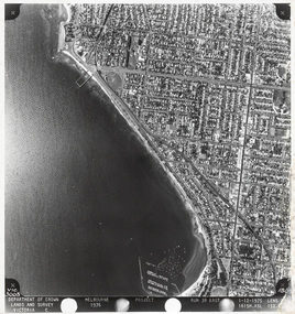
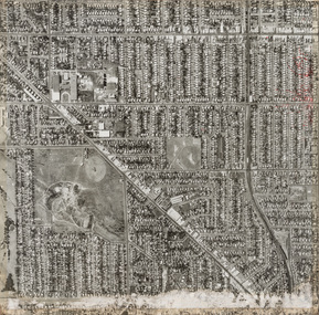
Photograph, Department of Crown Lands and Survey, Victoria, Melbourne Project: Brighton, Hampton, Sandringham, 1976
... ...Department of Crown Lands and Survey...The Department of Crown Lands and Survey (1857-1983) was responsible for the administration of survey and mapping and the sale, occupation and management of crown land throughout its existence. ...Department of Crown Lands and Survey, Victoria...Melbourne Project: Brighton, Hampton, Sandringham Photograph photograph Department of Crown Lands and Survey, Victoria ...The Department of Crown Lands and Survey (1857-1983) was responsible for the administration of survey and mapping and the sale, occupation and management of crown land throughout its existence. This aerial photograph shows parts of Brighton, Hampton and Sandringham and was taken on 1 December 1976brighton, department of crown lands and survey, aerial photograph, bayside, port phillip bay, map, cartographic material, hampton, sandringham, green point, sandringham yacht club, south road, beach road, hampton street, melbourne project 1976 -
 Bayside Gallery - Bayside City Council Art & Heritage Collection
Photograph, Department of Crown Lands and Survey, Victoria, Brighton, Elwood and Elsternwick, c. 1965-71
... ...Department of Crown Lands and Survey...The Department of Crown Lands and Survey (1857-1983) was responsible for the administration of survey and mapping and the sale, occupation and management of crown land throughout its existence. ...Department of Crown Lands and Survey, Victoria...Brighton, Elwood and Elsternwick Photograph photograph Department of Crown Lands and Survey, Victoria ...The Department of Crown Lands and Survey (1857-1983) was responsible for the administration of survey and mapping and the sale, occupation and management of crown land throughout its existence. This aerial photograph shows parts of Brighton, Elwood and Elsternwick and was taken circa 1965-71.brighton, department of crown lands and survey, aerial photograph, bayside, port phillip bay, map, cartographic material, elwood, elsternwick, elsternwick park, elwood tram depot, elwood pier, new street, glen huntly road, st kilda street, nepean highway -
 Bayside Gallery - Bayside City Council Art & Heritage Collection
Photograph, Department of Crown Lands and Survey, Victoria, Brighton, Brighton East and Bentleigh, c. 1965-71
... ...Department of Crown Lands and Survey...The Department of Crown Lands and Survey (1857-1983) was responsible for the administration of survey and mapping and the sale, occupation and management of crown land throughout its existence. ...Department of Crown Lands and Survey, Victoria...Brighton, Brighton East and Bentleigh Photograph photograph Department of Crown Lands and Survey, Victoria ...The Department of Crown Lands and Survey (1857-1983) was responsible for the administration of survey and mapping and the sale, occupation and management of crown land throughout its existence. This aerial photograph shows parts of Brighton and Brighton East and was taken circa 1965-71.brighton, department of crown lands and survey, aerial photograph, bayside, port phillip bay, map, cartographic material, brighton east, dendy park, dendy street, centre road, nepean highway, south road, brighton golf course, golf -
 Bayside Gallery - Bayside City Council Art & Heritage Collection
Photograph, Department of Crown Lands and Survey, Victoria, Brighton, Brighton East and Bentleigh, c. 1965-71
... ...Department of Crown Lands and Survey...The Department of Crown Lands and Survey (1857-1983) was responsible for the administration of survey and mapping and the sale, occupation and management of crown land throughout its existence. ...Department of Crown Lands and Survey, Victoria...Brighton, Brighton East and Bentleigh Photograph photograph Department of Crown Lands and Survey, Victoria ...The Department of Crown Lands and Survey (1857-1983) was responsible for the administration of survey and mapping and the sale, occupation and management of crown land throughout its existence. This aerial photograph shows parts of Brighton, Brighton East and Bentleigh and was taken circa 1965-71.brighton, department of crown lands and survey, aerial photograph, bayside, port phillip bay, map, cartographic material, bentleigh, brighton east, dendy park, dendy street, centre road, nepean highway, south road, football -
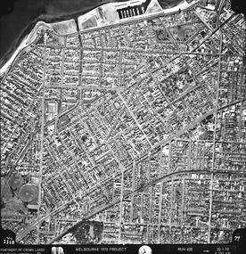
 St Kilda Historical Society
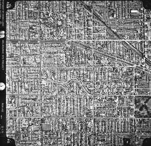
Photograph - Photo map, Department of Crown Lands and Survey (1857-1983), 22/01/1970
... One of a series of photo-maps produced for the Department of Crown Lands and Survey (1857-1983). For correlation with a current map, and access to other historical photo maps of Victoria, see the Historic Photo-Maps Index published by the Department of Environment, Land, Water and Planning at https://services.land.vic.gov.au/DELWPmaps/historical-photomaps/...Vic 2358 Department of Crown Lands and Survey Victoria,.© Melbourne 1970 Project Run 41E 22.1.70 5,100 ASL 62...Department of Crown Lands and Survey (1857-1983)...St Kilda Historical Society St Kilda Branch Library 150 Carlisle Street St Kilda melbourne One of a series of photo-maps produced for the Department of Crown Lands and Survey (1857-1983). For correlation with a current map, and access to other historical photo maps of Victoria, see the Historic Photo-Maps Index published by the Department of Environment, Land, Water and Planning at https://services.land.vic.gov.au/DELWPmaps/historical-photomaps/ Caulfield Caulfield North St Kilda EAst Armadale 1970 Vic 2358 Department of Crown Lands and Survey Victoria,.© Melbourne 1970 Project Run 41E 22.1.70 5,100 ASL 62 Black and white aerial photograph Photograph Photo map Department of Crown Lands and Survey (1857-1983) ...One of a series of photo-maps produced for the Department of Crown Lands and Survey (1857-1983). For correlation with a current map, and access to other historical photo maps of Victoria, see the Historic Photo-Maps Index published by the Department of Environment, Land, Water and Planning at https://services.land.vic.gov.au/DELWPmaps/historical-photomaps/Black and white aerial photographVic 2358 Department of Crown Lands and Survey Victoria,.© Melbourne 1970 Project Run 41E 22.1.70 5,100 ASL 62caulfield, caulfield north, st kilda east, armadale, 1970 -
 St Kilda Historical Society
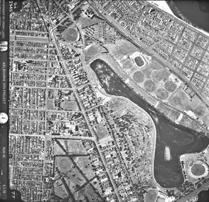
Photograph - Photo map, Department of Crown Lands and Survey (1857-1983), 22/01/1970
... One of a series of photo-maps produced for the Department of Crown Lands and Survey (1857-1983). For correlation with a current map, and access to other historical photo maps of Victoria, see the Historic Photo-Maps Index published by the Department of Environment, Land, Water and Planning at https://services.land.vic.gov.au/DELWPmaps/historical-photomaps/...Vic 2358 Department of Crown Lands and Survey Victoria,.© Melbourne 1970 Project Run 42E 22.1.70 5,100 ASL 77...Department of Crown Lands and Survey (1857-1983)...St Kilda Historical Society St Kilda Branch Library 150 Carlisle Street St Kilda melbourne One of a series of photo-maps produced for the Department of Crown Lands and Survey (1857-1983). For correlation with a current map, and access to other historical photo maps of Victoria, see the Historic Photo-Maps Index published by the Department of Environment, Land, Water and Planning at https://services.land.vic.gov.au/DELWPmaps/historical-photomaps/ St Kilda St Kilda East St Kilda Marina Elwood Elwood canal Elsternwick Park Point Ormond Balaclava MC Moran Reserve Ripponlea St Kilda Botanical Gardens Peanut farm 1970 Vic 2358 Department of Crown Lands and Survey Victoria,.© Melbourne 1970 Project Run 42E 22.1.70 5,100 ASL 77 Black and white aerial photograph Photograph Photo map Department of Crown Lands and Survey (1857-1983) ...One of a series of photo-maps produced for the Department of Crown Lands and Survey (1857-1983). For correlation with a current map, and access to other historical photo maps of Victoria, see the Historic Photo-Maps Index published by the Department of Environment, Land, Water and Planning at https://services.land.vic.gov.au/DELWPmaps/historical-photomaps/Black and white aerial photographVic 2358 Department of Crown Lands and Survey Victoria,.© Melbourne 1970 Project Run 42E 22.1.70 5,100 ASL 77st kilda, st kilda east, st kilda marina, elwood, elwood canal, elsternwick park, point ormond, balaclava, mc moran reserve, ripponlea, st kilda botanical gardens, peanut farm, 1970 -
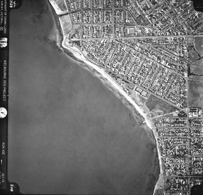 St Kilda Historical Society
Photograph - Photo map, Department of Crown Lands and Survey, 22/01/1970
... One of a series of photo-maps produced for the Department of Crown Lands and Survey (1857-1983). For correlation with a current map, and access to other historical photo maps of Victoria, see the Historic Photo-Maps Index published by the Department of Environment, Land, Water and Planning at https://services.land.vic.gov.au/DELWPmaps/historical-photomaps/...Vic 2358 Department of Crown Lands and Survey Victoria,.© Melbourne 1970 Project Run 43E 22.1.70 5,100 ASL 208...Department of Crown Lands and Survey ...St Kilda Historical Society St Kilda Branch Library 150 Carlisle Street St Kilda melbourne One of a series of photo-maps produced for the Department of Crown Lands and Survey (1857-1983). For correlation with a current map, and access to other historical photo maps of Victoria, see the Historic Photo-Maps Index published by the Department of Environment, Land, Water and Planning at https://services.land.vic.gov.au/DELWPmaps/historical-photomaps/ Elwood Elwood beach Point Ormond Elwood Park Elwood canal MC Moran Reserve 1970 Vic 2358 Department of Crown Lands and Survey Victoria,.© Melbourne 1970 Project Run 43E 22.1.70 5,100 ASL 208 Black and white aerial photograph Photograph Photo map Department of Crown Lands and Survey ...One of a series of photo-maps produced for the Department of Crown Lands and Survey (1857-1983). For correlation with a current map, and access to other historical photo maps of Victoria, see the Historic Photo-Maps Index published by the Department of Environment, Land, Water and Planning at https://services.land.vic.gov.au/DELWPmaps/historical-photomaps/Black and white aerial photographVic 2358 Department of Crown Lands and Survey Victoria,.© Melbourne 1970 Project Run 43E 22.1.70 5,100 ASL 208elwood, elwood beach, point ormond, elwood park, elwood canal, mc moran reserve, 1970 -
 St Kilda Historical Society
Photograph - Photo map, Department of Crown Lands and Survey, 22/01/1970
... One of a series of photo-maps produced for the Department of Crown Lands and Survey (1857-1983). For correlation with a current map, and access to other historical photo maps of Victoria, see the Historic Photo-Maps Index published by the Department of Environment, Land, Water and Planning at https://services.land.vic.gov.au/DELWPmaps/historical-photomaps/...Vic 2358 Department of Crown Lands and Survey Victoria,.© Melbourne 1970 Project Run 42E 22.1.70 5,100 ASL 75...Department of Crown Lands and Survey ...St Kilda Historical Society St Kilda Branch Library 150 Carlisle Street St Kilda melbourne One of a series of photo-maps produced for the Department of Crown Lands and Survey (1857-1983). For correlation with a current map, and access to other historical photo maps of Victoria, see the Historic Photo-Maps Index published by the Department of Environment, Land, Water and Planning at https://services.land.vic.gov.au/DELWPmaps/historical-photomaps/ St Kilda St Kilda beach St Kilda marina Point Ormond St Kilda pier 1970 Vic 2358 Department of Crown Lands and Survey Victoria,.© Melbourne 1970 Project Run 42E 22.1.70 5,100 ASL 75 Black and white aerial photograph Photograph Photo map Department of Crown Lands and Survey ...One of a series of photo-maps produced for the Department of Crown Lands and Survey (1857-1983). For correlation with a current map, and access to other historical photo maps of Victoria, see the Historic Photo-Maps Index published by the Department of Environment, Land, Water and Planning at https://services.land.vic.gov.au/DELWPmaps/historical-photomaps/Black and white aerial photographVic 2358 Department of Crown Lands and Survey Victoria,.© Melbourne 1970 Project Run 42E 22.1.70 5,100 ASL 75st kilda, st kilda beach, st kilda marina, point ormond, st kilda pier, 1970 -
 St Kilda Historical Society
Photograph - Photo map, Department of Crown Lands and Survey, 22/01/1970
... One of a series of photo-maps produced for the Department of Crown Lands and Survey (1857-1983). For correlation with a current map, and access to other historical photo maps of Victoria, see the Historic Photo-Maps Index published by the Department of Environment, Land, Water and Planning at https://services.land.vic.gov.au/DELWPmaps/historical-photomaps/...Vic 2358 Department of Crown Lands and Survey Victoria,.© Melbourne 1970 Project Run 41E 22.1.70 5,100 ASL 64...Department of Crown Lands and Survey ...St Kilda Historical Society St Kilda Branch Library 150 Carlisle Street St Kilda melbourne One of a series of photo-maps produced for the Department of Crown Lands and Survey (1857-1983). For correlation with a current map, and access to other historical photo maps of Victoria, see the Historic Photo-Maps Index published by the Department of Environment, Land, Water and Planning at https://services.land.vic.gov.au/DELWPmaps/historical-photomaps/ St Kilda St Kilda cemetery Balaclava St Kilda East Windsor Caulfield North Alma Park 1970 Vic 2358 Department of Crown Lands and Survey Victoria,.© Melbourne 1970 Project Run 41E 22.1.70 5,100 ASL 64 Black and white aerial photograph Photograph Photo map Department of Crown Lands and Survey ...One of a series of photo-maps produced for the Department of Crown Lands and Survey (1857-1983). For correlation with a current map, and access to other historical photo maps of Victoria, see the Historic Photo-Maps Index published by the Department of Environment, Land, Water and Planning at https://services.land.vic.gov.au/DELWPmaps/historical-photomaps/Black and white aerial photographVic 2358 Department of Crown Lands and Survey Victoria,.© Melbourne 1970 Project Run 41E 22.1.70 5,100 ASL 64st kilda, st kilda cemetery, balaclava, st kilda east, windsor, caulfield north, alma park, 1970 -
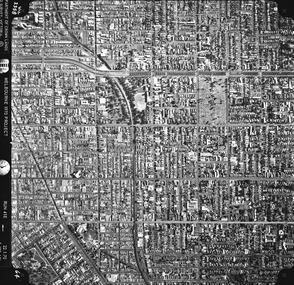
 St Kilda Historical Society
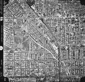
Photograph - Photo map, Department of Crown Lands and Survey, 08/01/1970
... One of a series of photo-maps produced for the Department of Crown Lands and Survey (1857-1983). For correlation with a current map, and access to other historical photo maps of Victoria, see the Historic Photo-Maps Index published by the Department of Environment, Land, Water and Planning at https://services.land.vic.gov.au/DELWPmaps/historical-photomaps/...Vic 2345 Department of Crown Lands and Survey Victoria,.© Melbourne 1970 Project Run 40 8.1.70 5,100 ASL 77...Department of Crown Lands and Survey ...St Kilda Historical Society St Kilda Branch Library 150 Carlisle Street St Kilda melbourne One of a series of photo-maps produced for the Department of Crown Lands and Survey (1857-1983). For correlation with a current map, and access to other historical photo maps of Victoria, see the Historic Photo-Maps Index published by the Department of Environment, Land, Water and Planning at https://services.land.vic.gov.au/DELWPmaps/historical-photomaps/ Albert Park Fawkner Park South Yarra Middle Park Prahran Windsor St Kilda St Kilda West 1970 Vic 2345 Department of Crown Lands and Survey Victoria,.© Melbourne 1970 Project Run 40 8.1.70 5,100 ASL 77 Black and white arial photograph Photograph Photo map Department of Crown Lands and Survey ...One of a series of photo-maps produced for the Department of Crown Lands and Survey (1857-1983). For correlation with a current map, and access to other historical photo maps of Victoria, see the Historic Photo-Maps Index published by the Department of Environment, Land, Water and Planning at https://services.land.vic.gov.au/DELWPmaps/historical-photomaps/Black and white arial photographVic 2345 Department of Crown Lands and Survey Victoria,.© Melbourne 1970 Project Run 40 8.1.70 5,100 ASL 77albert park, fawkner park, south yarra, middle park, prahran, windsor, st kilda, st kilda west, 1970 -
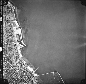
 St Kilda Historical Society
Photograph - Photo map, 22/01/1970
... One of a series of photo-maps produced for the Department of Crown Lands and Survey (1857-1983). For correlation with a current map, and access to other historical photo maps of Victoria, see the Historic Photo-Maps Index published by the Department of Environment, Land, Water and Planning at https://services.land.vic.gov.au/DELWPmaps/historical-photomaps/...Vic 2358 Department of Crown Lands and Survey Victoria,.© Melbourne 1970 Project Run 43E 22.1.70 5,100 ASL 206...Department of Crown Lands and Survey ...St Kilda Historical Society St Kilda Branch Library 150 Carlisle Street St Kilda melbourne One of a series of photo-maps produced for the Department of Crown Lands and Survey (1857-1983). For correlation with a current map, and access to other historical photo maps of Victoria, see the Historic Photo-Maps Index published by the Department of Environment, Land, Water and Planning at https://services.land.vic.gov.au/DELWPmaps/historical-photomaps/ Elwood Elsternwick Elsternwick Park 1970 Vic 2358 Department of Crown Lands and Survey Victoria,.© Melbourne 1970 Project Run 43E 22.1.70 5,100 ASL 206 Black and white aerial photograph Photograph Photo map Department of Crown Lands and Survey ...One of a series of photo-maps produced for the Department of Crown Lands and Survey (1857-1983). For correlation with a current map, and access to other historical photo maps of Victoria, see the Historic Photo-Maps Index published by the Department of Environment, Land, Water and Planning at https://services.land.vic.gov.au/DELWPmaps/historical-photomaps/Black and white aerial photographVic 2358 Department of Crown Lands and Survey Victoria,.© Melbourne 1970 Project Run 43E 22.1.70 5,100 ASL 206elwood, elsternwick, elsternwick park, 1970 -
 St Kilda Historical Society
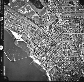
Photograph - Photo map, Department of Crown Lands and Survey, 22/01/1970
... One of a series of photo-maps produced for the Department of Crown Lands and Survey (1857-1983). For correlation with a current map, and access to other historical photo maps of Victoria, see the Historic Photo-Maps Index published by the Department of Environment, Land, Water and Planning at https://services.land.vic.gov.au/DELWPmaps/historical-photomaps/...CONTROLLED Vic 2358 Department of Crown Lands and Survey Victoria,.© Melbourne 1970 Project Run 41E 22.1.70 5,100 ASL 66...Department of Crown Lands and Survey ...St Kilda Historical Society St Kilda Branch Library 150 Carlisle Street St Kilda melbourne One of a series of photo-maps produced for the Department of Crown Lands and Survey (1857-1983). For correlation with a current map, and access to other historical photo maps of Victoria, see the Historic Photo-Maps Index published by the Department of Environment, Land, Water and Planning at https://services.land.vic.gov.au/DELWPmaps/historical-photomaps/ St Kilda Albert Park St Kilda West Catani Gardens St Kilda Botanical Gardens St Kilda pier St Kilda beach 1970 CONTROLLED Vic 2358 Department of Crown Lands and Survey Victoria,.© Melbourne 1970 Project Run 41E 22.1.70 5,100 ASL 66 Black and white aerial photograph Photograph Photo map Department of Crown Lands and Survey ...One of a series of photo-maps produced for the Department of Crown Lands and Survey (1857-1983). For correlation with a current map, and access to other historical photo maps of Victoria, see the Historic Photo-Maps Index published by the Department of Environment, Land, Water and Planning at https://services.land.vic.gov.au/DELWPmaps/historical-photomaps/Black and white aerial photographCONTROLLED Vic 2358 Department of Crown Lands and Survey Victoria,.© Melbourne 1970 Project Run 41E 22.1.70 5,100 ASL 66st kilda, albert park, st kilda west, catani gardens, st kilda botanical gardens, st kilda pier, st kilda beach, 1970 -
 Peterborough History Group
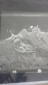
Photograph - Aerial Photograph Peterborough, Department of Crown Lands & Survey, Jan 1971
... ...Department of Crown Lands...Department of Crown Lands & Survey...Peterborough History Group Peterborough great-ocean-road Aerial photograph showing the past layout of the town Significant in that it shows the town as it was in 1971. peterborough 3270 curdies estuary bay of islands crown land photograph aerial photograph Department of Crown Lands Stamped Dept of Crown Lands & Survey Square 9" x 9" aerial photograph x 4 - (2 photos in duplicate) Photograph Aerial Photograph Peterborough Department of Crown Lands & Survey ...Aerial photograph showing the past layout of the townSignificant in that it shows the town as it was in 1971.Square 9" x 9" aerial photograph x 4 - (2 photos in duplicate)Stamped Dept of Crown Lands & Surveypeterborough 3270, curdies estuary, bay of islands, crown land photograph, aerial photograph, department of crown lands -
 Whitehorse Historical Society Inc.
Document, Department of Crown Lands and Survey, 1983
... Department of Crown Lands and Survey...Research guide of historical resources of the Department of Crown Lands and Survey. Compiled by P. ...Cabena, Aug 1983 Department of Crown Lands and Survey Document Document ...Research guide of historical resources of the Department of Crown Lands and Survey. Compiled by P. Cabena, Aug 1983Research guide of historical resources of the Department of Crown Lands and Survey. Compiled by P. Cabena, Aug 1983Research guide of historical resources of the Department of Crown Lands and Survey. Compiled by P. Cabena, Aug 1983crown land, land surveys, victorian government -
Stawell Historical Society Inc
Map, Department of Crown Lands and Survey Victoria, Allotments in the Township of Banyana. Parish of Burrum Burrum. 1946 / 1971, 1971
... Drawn and reproduced at the Department of Crown Lands and Survey Victoria 1971....Department of Crown Lands and Survey Victoria...Parish of Burrum Burrum. 1946 / 1971 Map Department of Crown Lands and Survey Victoria ...Richardson River. Avon River JunctionPaper Map of County of BorungReprint of the 1946 edition. Drawn and reproduced at the Department of Crown Lands and Survey Victoria 1971.survey -
University of Melbourne, Burnley Campus Archives
Document - Circular, Department of Crown Lands and Survey. Complete list of weeds declared noxious in the State of Victoria, 1964-1972
... Department of Crown Lands and Survey. Complete list of weeds declared noxious in the State of Victoria...Includes tables of Chemical Treatment and other remarks. weeds Vermin and Noxious Weeds Act 1928 chemical treatment of weeds Large circular - Complete list of weeds proclaimed noxious within the State of Victoria and for certain Municipalities and table of quantities for chemical treatment together with brief instructions for treatment of Noxious Weeds (Vermin and Noxious Weeds Act 1928) Department of Crown Lands and Survey. Complete list of weeds declared noxious in the State of Victoria Document Circular ...Chart prepared by Vermin and Noxious Weeds branch. Plants proclaimed under the Noxious Weeds Act 1928 (No 3799) for the State of Victoria.. Plants proclaimed within certain Municipalities of Victoria. Includes tables of Chemical Treatment and other remarks.Large circular - Complete list of weeds proclaimed noxious within the State of Victoria and for certain Municipalities and table of quantities for chemical treatment together with brief instructions for treatment of Noxious Weeds (Vermin and Noxious Weeds Act 1928)weeds, vermin and noxious weeds act 1928, chemical treatment of weeds -
 Whitehorse Historical Society Inc.
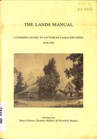
Manual - Government (Lands Dept), Royal Historical Society of Victoria, The Lands Manual - A Finding Guide to Victorian Land Records 1836 - 1983, March 1989
... Crown Lands...Victoria. Department of Crown Lands and Survey...The manual documents the archives of the Department of Crown Lands and Survey (Lands Department) and explains how they can be used for historical research.... Victoria. Department of Crown Lands and Survey The manual documents the archives of the Department of Crown Lands and Survey (Lands Department) between 1836 to 1983 and explains how they can be used for historical research. ...The manual documents the archives of the Department of Crown Lands and Survey (Lands Department) between 1836 to 1983 and explains how they can be used for historical research.The manual documents the archives of the Department of Crown Lands and Survey (Lands Department) and explains how they can be used for historical research.The manual documents the archives of the Department of Crown Lands and Survey (Lands Department) between 1836 to 1983 and explains how they can be used for historical research.crown lands, victoria. department of crown lands and survey -
 Federation University Historical Collection
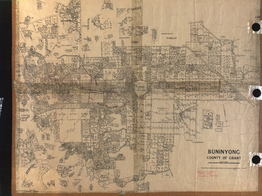
Plan, Department of Crown Lands and Survey, Melbourne, Buninyong County of Grant, 23/07/1929
... Department of Crown Lands and Survey, Melbourne...Buninyong County of Grant Plan Department of Crown Lands and Survey, Melbourne ...The plan was photo-lithographed at the Departmen tof Lands and Survey, MelbourneA parish plan of Buninyong, including Robert Scott's Mt Buninyong Pre-emptive Right, Mt Buninyong Public Park, Thomas Learmonth's land, John Learmonth's land, Scotchan's, Yendon. The Buninyong POst Office is Allotment 1. Pisition of tracks in 1859 have been marked on the plan in red.buninyong, scotchman's, mt buninyong, robert scott, clarendon, lal lal creek, yendon, warrenheip, yarowee, enfield, thomas learmonth, john learmonth, archibald fisken, g. schloo, george innes, peter inglis, durham lead, j. fry, j. forrest, parkin lee, buninyong recreation reserve -
 Eltham District Historical Society Inc
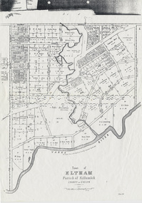
Document - Map, Victoria. Department of Crown Lands and Survey, Town of Eltham, Parish of Nillumbik, County of Evelyn, 2 October 1929
... Victoria. Department of Crown Lands and Survey...Schultz William Thomas Eltham Primary School Eltham State School Eltham State School No. 209 Quarry Reserve A3 size photocopy Town of Eltham, Parish of Nillumbik, County of Evelyn Document Map Victoria. Department of Crown Lands and Survey ...Township of Eltham, Parish of Nillumbik, County of Evelyn / lithographed at the Department of Lands & Survey Melbourne 5th June 1888, amended 2 October 1929 This amendment from the 1888 original shows the reserve for the the State School marked as permanent with dimensions added to Main Road and block frontages along Main Road between Mount Pleasant Road and Dalton Street and Metery Road Possibly photocopied from a copy held at PROV by Harry Gilham whilst resaerching Eltham Primary School history in 1995.a. armstrong, a. lavard, arthur c. allan, arthur c. allen, b. bowatere, baxter street, benjamin oliver wallis, bolton steet, c. souter, c.s. hain, cemetery reserve, charles brown, charles newman, charles symons wingrove, christopher caldwell, church of england, d. anderson, dalton street, david ballard, e. james, e.m. peck, edward dumaresq, eltham town, ely street, f.e. falkiner, f.m. peck, falkiner street, flint street, g. buckingham, g. drabble, george stebbing, godalmin street, h. peck, h.c.whess, h.h. farquharson, h.j. bews, henry stooke, j. goer, j. mcdonald, j. mclaren, j. roberts, j.b. knagers, james irish, jane bailey (nee matthews), john l. smith, john mason, john scott, john smith, joseph stevenson, joseph verse, k. wingrove, k.e. dunstan, kerby street, kirby street, location tbd, m. coman, map, michael o'shea, o.b. mccutcheon, p. & g. tumbull, p.k. mccaughan, p.p. cotter, porter street, pound reserve, robert hepburn, roman catholic church, s. evans, samuel dagley, samuel phillips, samuel ramsden, t. upton, t. watkins, t.a. stark, t.c.b. batt, t.p. cross, thomas grant, thornton street, w. adam, w. blain, w. long, w. watkins, w.f. ford, w.h. hull, w.r. belcher, w.t. schultz, william thomas, eltham primary school, eltham state school, eltham state school no. 209, quarry reserve -
 Greensborough Historical Society
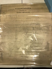
Map, Victoria. Department of Crown Lands and Survey, Keelbundoora; Counties of Bourke and Evelyn, 1950c
... Victoria. Department of Crown Lands and Survey...Keelbundoora; Counties of Bourke and Evelyn Map Victoria. Department of Crown Lands and Survey ...Map of the Victorian counties of Bourke and Evelyn showing parish boundaries and land ownership.Show the original landholders for this area.Map on light brown parchment, covered in plastic."L.5305" and "3462" -
 Orbost & District Historical Society
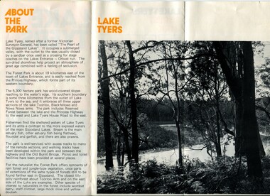
pamphlet, Lake Tyers Forest Park, 1960's
... Department of Crown Lands & Survey...Lake Tyers Forest Park pamphlet Department of Crown Lands & Survey ...This pamphlet would have been produced as a tourist guide to East Gippsland.This item is a useful reference tool.A three fold glossy, pamphlet titled"Lake Tyers Forest Park". It contains information, a map and black / white photographs of Lake Tyers Park. Print colours are brown, white, yellow and black.pamphlet lake tyers-forest-park -
 Orbost & District Historical Society
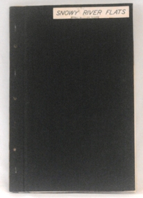
plans, 1966?
... plans-survey Snowy-River-Flats Department-Crown-Lands-Victoria...Department of Crown Lands & Survey...It contains plans. plans Department of Crown Lands & Survey ...These survey plans are a useful research tool.A flat green fabric folder with a white label with "SNOWY RIVER FLATS" hand-written in black. It contains plans.plans-survey snowy-river-flats department-crown-lands-victoria -
 Federation University Historical Collection
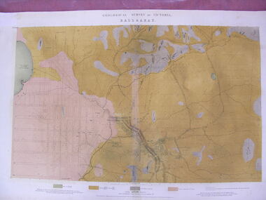
Map - Geological Survey, J. Phillips, Geological Survey of Victoria - Ballarat, 1857, 10/1858
... ...Department of Crown Lands and Survey, Melbourne...Phillips Department of Crown Lands and Survey, Melbourne ...Geological map of the Ballarat District featuring four colours.ballarat, geological, geology, geological plan, main road, camp, golden point, pennyweight hill, clayton hill, ballaarat cemetery, bakery hill, specimen hill, soldiers hill, nightingale lead, native youth black hill flat, white flat, mining, mines, eureka lead, old post office hill -
 Bayside Gallery - Bayside City Council Art & Heritage Collection
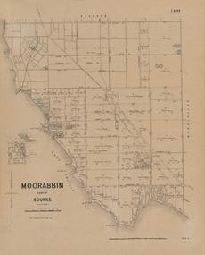
Map, Department of Crown Lands and Survey, Moorabbin, County of Bourke, c. 1918
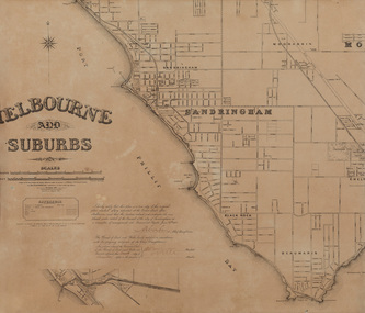
... Department of Crown Lands and Survey...Department of Lands and Survey Land owners cartographic material Borough of Sandringham Brighton Photolithograph. Printed in black ink on cream paper, the map shows street names, subdivision of blocks, sizes of the blocks and the names of the landowners. Port Phillip Bay is on the left, with land extending from Sandringham foreshore through to Cheltenham. The most detail is between Brighton Beach Railway Station (to the north) and just past Rickett's Point (to the south) but the map extends to North Road, Brighton at top. Moorabbin, County of Bourke Map map Department of Crown ...The cadastral map of the Parish of Moorabbin in Victoria (L.6104) shows parish boundaries and land ownership c. 1918 when Sandringham was a Borough.moorabbin, county of bourke, map, plan, land subdivision, land titles, foreshores, sndringham, hampton, beaumaris, highett, cheltenham, department of lands and survey, land owners, cartographic material, borough of sandringham, brighton -
 Bayside Gallery - Bayside City Council Art & Heritage Collection
Map, Department of Crown Lands and Survey, Melbourne and Suburbs, City of Sandringham, 1917-1926
... Department of Crown Lands and Survey...Department of Lands and Survey, Melbourne that indicates area placed under control of the Council of City of Sandringham, on 27 June 1917. Key indicates that the map shows Boundaries of Municipalities and Districts within the Municipalities; Railway lines; Cable, Electric and Horse Tramways. At lowest point of Map is Rickett's Point, top point shows Brighton Beach Pier. Suburbs include Sandringham, Black Rock, Beaumaris and parts of Cheltenham and Moorabbin. This was printed in 1926 and is a copy of the original plan from 1917. Melbourne and Suburbs, City of Sandringham Map map Department of Crown ...map, plan, foreshores, sndringham, hampton, beaumaris, cheltenham, department of lands and survey, cartographic material, borough of sandringham, moorabbin, black rock, street map, city of sandringham -
 Bayside Gallery - Bayside City Council Art & Heritage Collection
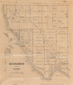
Map, Department of Crown Lands and Survey et al, Moorabbin, County of Bourke, Government Roads, 1920
... Department of Crown Lands and Survey...Moorabbin, County of Bourke, Government Roads Map map Department of Crown Lands and Survey W.J. Butson ...The cadastral map of the Parish of Moorabbin in Victoria (L.6104) shows parish boundaries and land ownership 1920 when Sandringham was a Town. The government roads have been coloured in red pencil.moorabbin, county of bourke, map, plan, land subdivision, land titles, foreshores, hampton, beaumaris, highett, cheltenham, department of lands and survey, land owners, cartographic material, brighton, sandringham, town of sandringham, government roads -
 Victorian Aboriginal Corporation for Languages
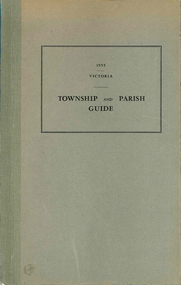
Book, Department of Crown Lands and Survey Victoria, Township and parish guide : Victoria, 1955
... Department of Crown Lands and Survey Victoria...Township and parish guide : Victoria Book Department of Crown Lands and Survey Victoria ...A alphabetical list of townships proclaimed under the Land Acts of Victoria. Shows the parish, land district and the municipality in which each is situated, and the particulars of Gazettal of Proclamation.victorian geographical names, victorian administration