Showing 144 items matching "development – kew (vic.)"
-
 Kew Historical Society Inc
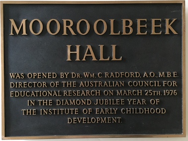
Plaque, Institute of Early Childhood Development, Mooroolbeek Hall, 1976
... institute of early childhood development - kew (vic)...Kew. In 1965, the institution, as the Melbourne Kindergarten Teachers' College, became an entity separate from the Union, and in 1973 joined the State College of Victoria as the Institute of Early Childhood Development. It subsequently amalgamated with the University of Melbourne to become the Department of Early Childhood Studies and moved from Madden Grove, Kew, to 234 Queensberry St, Carlton, early in July 1997. institute of early childhood development - kew (vic) dr william c. radford memorial plaques - kew (vic) mooroolbeek hall Mooroolbeek Hall was opened by Dr Wm C. ...The Free Kindergarten Union of Victoria commenced teacher training in 1909. A two year course was run in cooperation with the Education Department in 1910-14, but from 1917 the Union trained its students independently. In 1922 the Kindergarten Training College was established in Mooroolbeek, Kew. In 1965, the institution, as the Melbourne Kindergarten Teachers' College, became an entity separate from the Union, and in 1973 joined the State College of Victoria as the Institute of Early Childhood Development. It subsequently amalgamated with the University of Melbourne to become the Department of Early Childhood Studies and moved from Madden Grove, Kew, to 234 Queensberry St, Carlton, early in July 1997.Metal plaque commemorating the opening of Mooroolbeek Hall in the Diamond Jubilee Year of the Institute of Early Childhood Development in KewMooroolbeek Hall was opened by Dr Wm C. Radford, AO, MBE, Director of the Australian Council for Educational Research on March 25th 1976 in the Diamond Jubilee Year of the Institute for Early Childhood Developmentinstitute of early childhood development - kew (vic), dr william c. radford, memorial plaques - kew (vic), mooroolbeek hall -
 Kew Historical Society Inc
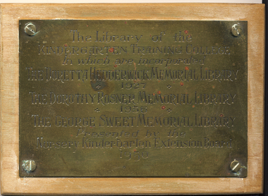
Plaque - Commemorative Plaque, Institute of Early Childhood Development, Opening of the Library of the Kindergarten Training College, Kew, 1950, 1950
... institute of early childhood development - kew (vic)...Kew. In 1965, the institution, as the Melbourne Kindergarten Teachers' College, became an entity separate from the Union, and in 1973 joined the State College of Victoria as the Institute of Early Childhood Development. It subsequently amalgamated with the University of Melbourne to become the Department of Early Childhood Studies and moved from Madden Grove, Kew, to 234 Queensberry St, Carlton, early in July 1997. institute of early childhood development - kew (vic) libraries - education - early childhood - kew (vic) doretta hedderwick memorial library 1927 dorothy rosner memorial library 1936 george sweet memorial library nursery kindergarten exrension board The library of the Kindergarten Training College in which are incorporated the Doretta Hedderwick Memorial 1927, the Dorothy Rosner Memorial 1936, the George Sweet Memorial Library - Presented by the Nursery Kindergarten Exrension Board 1950 Small brass plaque mounted on wood commemorating the libraries of the Kindergarten Training College in Kew. ...The Free Kindergarten Union of Victoria commenced teacher training in 1909. A two year course was run in cooperation with the Education Department in 1910-14, but from 1917 the Union trained its students independently. In 1922 the Kindergarten Training College was established in Mooroolbeek, Kew. In 1965, the institution, as the Melbourne Kindergarten Teachers' College, became an entity separate from the Union, and in 1973 joined the State College of Victoria as the Institute of Early Childhood Development. It subsequently amalgamated with the University of Melbourne to become the Department of Early Childhood Studies and moved from Madden Grove, Kew, to 234 Queensberry St, Carlton, early in July 1997.Small brass plaque mounted on wood commemorating the libraries of the Kindergarten Training College in Kew.The library of the Kindergarten Training College in which are incorporated the Doretta Hedderwick Memorial 1927, the Dorothy Rosner Memorial 1936, the George Sweet Memorial Library - Presented by the Nursery Kindergarten Exrension Board 1950institute of early childhood development - kew (vic), libraries - education - early childhood - kew (vic), doretta hedderwick memorial library 1927, dorothy rosner memorial library 1936, george sweet memorial library, nursery kindergarten exrension board -
 Kew Historical Society Inc
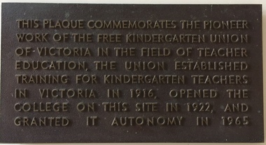
Plaque - Commemorative Plaque, Free Kindergarten Union of Victoria, Commemoration of the Free Kindergarten Union of Victoria, circa 1965, c.1965
... institute of early childhood development - kew (vic)...Kew. In 1965, the institution, as the Melbourne Kindergarten Teachers' College, became an entity separate from the Union, and in 1973 joined the State College of Victoria as the Institute of Early Childhood Development. It subsequently amalgamated with the University of Melbourne to become the Department of Early Childhood Studies and moved from Madden Grove, Kew, to 234 Queensberry St, Carlton, early in July 1997. Plaque recognising the site of an important educational institution for teacher training. institute of early childhood development - kew (vic ...The Free Kindergarten Union of Victoria commenced teacher training in 1909. A two year course was run in cooperation with the Education Department in 1910-14, but from 1917 the Union trained its students independently. In 1922 the Kindergarten Training College was established in Mooroolbeek, Kew. In 1965, the institution, as the Melbourne Kindergarten Teachers' College, became an entity separate from the Union, and in 1973 joined the State College of Victoria as the Institute of Early Childhood Development. It subsequently amalgamated with the University of Melbourne to become the Department of Early Childhood Studies and moved from Madden Grove, Kew, to 234 Queensberry St, Carlton, early in July 1997.Plaque recognising the site of an important educational institution for teacher training.Bronze plaque with raised lettering commemorating the role of the Free Kindergarten Union of Victoria which had opened in 1916"This plaque commemorates the pioneer work of the Free Kindergarten Union of Victoria in the field of teacher education, the Union established training for kindergarten teachers in Victoria in 1916, opened the college on this site in 1922, and granted it autonomy on 1965."institute of early childhood development - kew (vic), free kindergarten union of victoria, early childhood education - kew - victoria -
 Kew Historical Society Inc
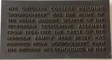
Plaque - Commemorative Plaque, Institute of Early Childhood Development, 'Mooroolbeek', Madden Grove, Kew, c.1968
... institute of early childhood development - kew (vic)...Kew. In 1965, the institution, as the Melbourne Kindergarten Teachers' College, became an entity separate from the Union, and in 1973 joined the State College of Victoria as the Institute of Early Childhood Development. It subsequently amalgamated with the University of Melbourne to become the Department of Early Childhood Studies and moved from Madden Grove, Kew, to 234 Queensberry St, Carlton, early in July 1997. Commemorative plaque indicating the location of a former Kew mansion institute of early childhood development - kew (vic ...The Free Kindergarten Union of Victoria commenced teacher training in 1909. A two year course was run in cooperation with the Education Department in 1910-14, but from 1917 the Union trained its students independently. In 1922 the Kindergarten Training College was established in Mooroolbeek, Kew. In 1965, the institution, as the Melbourne Kindergarten Teachers' College, became an entity separate from the Union, and in 1973 joined the State College of Victoria as the Institute of Early Childhood Development. It subsequently amalgamated with the University of Melbourne to become the Department of Early Childhood Studies and moved from Madden Grove, Kew, to 234 Queensberry St, Carlton, early in July 1997.Commemorative plaque indicating the location of a former Kew mansionBronze plaque commemorating the location of Mooroolbeek, one of the great mansions of Kew, demolished in 1968 by the Kindergarten Training College"The original college building "Mooroolbeek" was the home of Sir Frank Madden Speaker of the Victorian Legislative Assembly from 1904-1917. The crest of the Madden family here inset was removed from "Mooroolbeek" when the building was demolished in 1968."institute of early childhood development - kew (vic), mooroolbeek - madden grove - kew (vic), sir frank madden -
 Kew Historical Society Inc
Archive (Sub-series) - Subject File, Kew Historical Society, Institute of Early Childhood Development, 1958
... institute of early childhood development - kew (vic)...Typically files will contain primary and secondary sources. kew historical society - archives kew - history institute of early childhood development - kew (vic) kindergarten training - kew (vic) mooroolbeek Archive file containing a copy of the publication ‘Diamond Jubilee Institute of Early Childhood Development’, which includes a chronology and a brief history. ...Various partiesReference, Research, InformationSecondary Values (KHS Imposed Order)Subject file containing a copy of the publication ‘Diamond Jubilee Institute of Early Childhood Development’, which includes a chronology and a brief history. Reproductions of early photographs of Mooroolbeek are included in the publication. The publication included research by Rosemary Bopreham and photographs by Gavin Fry. In the archive file are three invitations to graduation ceremonies issued in 1952 and 1953, donated by Mrs C.S. Dickins.kew historical society - archives, kew - history, institute of early childhood development - kew (vic), kindergarten training - kew (vic), mooroolbeekkew historical society - archives, kew - history, institute of early childhood development - kew (vic), kindergarten training - kew (vic), mooroolbeek -
Kew Historical Society Inc
Archive (Series) - Urban Redevelopment
... Kew (Vic.)...Urbanisation – Kew (Vic.)...Development...Kew Historical Society Inc Kew Court House 188 High Street Kew melbourne Urban Redevelopment – Kew (Vic.) Urbanisation – Kew (Vic.) Development – Kew (Vic.) Archive Urban Redevelopment ...Various PartiesReference, Research, InformationArranged by Secondary Values (value of records to users)Urban redevelopment has always been a challenge for Kew and the surrounding area, due to the opposition from local residents. Attempts have been made to introduce new residential zones to increase the number of occupancies but most if not all have faced public backlash, over of the fear of the loss of heritage and natural amenity. The file includes: Multiple newspaper articles, an invitation to a committee meeting, correspondence between local government officials, a public permit application sent out to the community, a failed planning permit application, a precinct statement, and newsletters from the City of Boroondara.urban redevelopment – kew (vic.), urbanisation – kew (vic.), development – kew (vic.)urban redevelopment – kew (vic.), urbanisation – kew (vic.), development – kew (vic.) -
 Ringwood and District Historical Society
Document, Certificate of Title - W.G. Carter, Grandview Grove, Warranwood, Victoria, (later Bemboka Road) - part of Crown Section Twenty, Parish of Warrandyte, County of Evelyn - 1947
... Kew but later moved to Rosebud and sold the land without ever building on it. During the 1960s, Grandview Grove was renamed Bemboka Road. After retiring as a milkman, Bill moved to Rosebud, Vic, and in 1977, sold the property to the Anglican Church, who were looking to invest in the site in anticipation of proposed future residential development in the area. ...Kew but later moved to Rosebud and sold the land without ever building on it. During the 1960s, Grandview Grove was renamed Bemboka Road. After retiring as a milkman, Bill moved to Rosebud, Vic, and in 1977, sold the property to the Anglican Church, who were looking to invest in the site in anticipation of proposed future residential development in the area. ...A4 copies of Landata Victoria Historical Search documents - Vol 7052 Fol 1410222. Includes Carter Family Tree property notes. William George Carter of Grandview Grove Ringwood, Nurseryman, is now the proprietor - three acres or thereabouts shown on map (12202a) - 14th March, 1947. Transfer B284834 Registered 21 September, 1961 - 1 acre shown on map (12202c) north of Plymouth Road. NOTES ON GRANDVIEW GROVE PROPERTY (Carter Family Tree extract) The Grandview Grove property was purchased by William (Bill) and Doreen Carter in 1947 as three acres of uncleared bushland. They had a 2 bedroom fibro-cement house built on the land which they informally called "Willoreen". With Doreen looking after sons Peter (born in 1940) and Robin (born in 1950), Bill worked locally at Croydon Dairy. The family spent much of their spare time clearing the land, where Bill then grew and sold fruit, flowers and berries, particularly strawberries, as a hobby and to supplement their income. Bill continued to do so while Peter and Robin were growing up, and after Doreen died in 1958. In 1961 Bill sold one of the three acres to one of his seven sisters, Grace, who lived in Kew but later moved to Rosebud and sold the land without ever building on it. During the 1960s, Grandview Grove was renamed Bemboka Road. After retiring as a milkman, Bill moved to Rosebud, Vic, and in 1977, sold the property to the Anglican Church, who were looking to invest in the site in anticipation of proposed future residential development in the area. As nearby properties were subdivided during the 1980s, the house, which the Church had initially utilised as low-cost family accommodation, was modified internaly to become a church/Sunday school. By the early 2000s, construction of a contemporary-design church and carparking area between the house and street alignment had been completed but the house remained as a detatched meeting room until falling into disrepair and was eventually demolished around 2010. -
 City of Melbourne Libraries
Photograph, Bull, Hugh Jones, 1897-1993, Ruyton Girls School 1933
... As well as Tarring, the Henty family Melbourne residences included Findon (in Kew, overlooking Studley Park), Offington (St Kilda Road overlooking Albert Park) and Field Place (Henty Court, Kew), and descriptions of the houses in Wikipedia –Melbourne Architecture 1870s - reflect the development of Melbourne society. References RUYTON (1934, December 15). The Argus (Melbourne, Vic...As well as Tarring, the Henty family Melbourne residences included Findon (in Kew, overlooking Studley Park), Offington (St Kilda Road overlooking Albert Park) and Field Place (Henty Court, Kew), and descriptions of the houses in Wikipedia –Melbourne Architecture 1870s - reflect the development of Melbourne society. References RUYTON (1934, December 15). The Argus (Melbourne, Vic ...Published: Age (Melbourne, Vic.: 1854- ), 4 August 1933, page 3 Published title: GIRLS’ SCHOOLS – MODEL YACHTING - FOOTBALL Published caption: The headmistress, Miss H. Daniell, and girls at Ruyton, Selbourne Road, Kew, snapped after school hours. Trove article identifier: http://nla.gov.au/nla.news-article204381763 Research by Project Volunteer, Louise McKenzie: Rather than the people, this charming building takes the eye! Originally named “Tarring”, it was built in 1872 by Mr Henry Henty and his wife Mrs Marion Anne Henty (nee McKellar) for their family. Located at 82 Selbourne Road, Kew, it is described by Melbourne’s Open House organisation as “… a two-storey, polychrome brick mansion built for them by prominent Melbourne architect Albert Purchas. The house and nearly four acres of grounds served as their family home until the death of Marian Henty in 1919. “ (See below for further information on Albert Purchas.) In 1920 it was sold to Ruyton Girls School. Ruyton was established in 1878 by its first principal, Charlotte Anderson (1838-1906), who named it in honour of the parish in Shropshire, England, Ruyton-XI-Towns, where her great-great-grandfather David Evans had been vicar. Its motto is Recte et Fideliter, meaning "Upright and Faithful", which is also the name of the school song. The original school, one of Victoria’s oldest independent schools for girls, was located at the home of Mrs Anderson at 63 High Street South, Kew. In 1882 she moved the school to Edgecombe in Studley Park Road. Mrs Anderson retired due to ill health and sold the school to her friend Miss Eliza Bromby. One of Ruyton's four Houses, Anderson, is named for Charlotte Anderson. When Ruyton Girls School was moved to the site in 1920 it established the building as a Boarding House, and renamed the building “Henty House” in honour of its original owners. Today the school remains an all girls’ school, and pays tribute to its founder and the historic significance of Henty House and its magnificent Moreton Bay Fig tree, which still stands today. The building retains many original, Victorian-era features, while also showing the layers of change, made over the decades in order to meet the evolving needs of one of Melbourne’s leading schools. The headmistress mentioned in the caption for MCK016 is Miss Hilda Daniell, shown standing in front of Henty House in the midst of a group of Ruyton girls in their school uniforms, some holding hockey sticks. Miss Daniell was the longest serving Principal of Ruyton 1913-1952. She was originally a student in 1893, then joined the teaching staff in 1898. It was under her leadership that the School purchased and moved to “Tarring”. The boarding house included a flat for Hilda to live onsite. An article in the Ruyton Heritage Collection – Bedford Series, dated 21 May 2021 cites that Miss Daniell “was affectionately known as “Dream” by Ruytonians of her era” apparently due to a tendency to quiet reflection. The article continues, “After her retirement in 1952 Miss Daniell was awarded an Order of the British Empire for her many services to education, an award she received from the hands of the Queen during the 1954 Royal Tour. Also in 1952, the Kew Council honoured her by renaming Brougham Place as ‘Daniell Place’.” Arthur Purchas, architect: The architect responsible for the design of “Tarring”. Arthur Purchas, was extremely active and highly regarded at this time. Born in Wales in 1825, he emigrated to Melbourne in 1851 and soon established a private practice as a surveyor and architect, with offices variously in Little Collins, Queen Street, Chancery Lane, and finally 462 Little Collins Street. Wikipedia notes in an early reference to Purchas that “An early story is that one of his first jobs, when he would have been about 25 years old, was a position under Surveyor-General Robert Hoddle, and disagreeing with him over the line for St Kilda Road, appealed to Governor La Trobe, and successfully got the road diverted around the hill which eventually became the site of the Shrine of Remembrance. There may not be much truth to this, since by 1851 St Kilda Road was already a well worn track running around the hill, the top of which La Trobe had reserved for a Government House in 1840.” The timing of Purchas’s arrival in Melbourne was perfect. The Victorian gold rush of the 1850’s generated enormous wealth in Melbourne, and a building boom followed. The Wikipedia entry continues … that alone, or with his brother in law Charles R Swyer, “Purchas is said to have designed over 140 houses, offices, churches, banks and cemetery buildings in Victoria in his long career. Berkely Hall, St Kilda dating from 1854 is one of his first buildings, and still exists, though the original house is obscured by an early C20th verandah. Another notable early design was the head office of the Melbourne Savings Bank, built on the corner Flinders Lane and Market Street in 1857-58, in an elaborately detailed Renaissance Revival style. His churches were mostly Gothic Revival, built for the Anglican Church, along with some parsonages, while most of the bank buildings were Renaissance Revival designs for the Bank of Australasia. He also designed city buildings in the 1860s and 70s, such as the Mutual Insurance Co, Northern Insurance Co, and the first premises for George & George, destroyed by fire in 1889. One of his most outstanding designs is St George's Presbyterian Church in Chapel Street, St Kilda (1877–80), in a striking polychrome brick Gothic Revival style, unusually carried on through to the interior. Purchas produced one of the few published maps and compilations of the early pastoral settlers runs in Victoria in 1853. In the same year he designed the layout of the Melbourne General Cemetery, the first 'garden' cemetery in Victoria, a curvilinear layout with extensive plantings, as well as the gate lodge and gates (the gates lodge were demolished and the gates relocated to their present position in the 1930s). He was a long time member of the Cemetery Trust, serving as secretary from 1876-1886. He was also Chairman of the Boroondara General Cemetery Board of Trustees 1867 to 1909, and designed many aspects of the cemetery, including the landscape, the cast iron entrance gates (1889), the rotunda (1890) and the surrounding brick wall (1895–6). Purchas was a keen inventor having applied for a patent for an invention for lighting a railway carriage with gas in 1861, and won a competition for a model farm complex, in 1862. This unusual design had the dairy either underground or half underground, to keep it cool, with a 'dry lining' around the outside of the sunken portions. In 1883, with fellow architect Alfred Smith, he took out a patent for fire-proof floors, arches, staircases and other parts of buildings.” Purchas died in his home in Kew in 1909 and, not surprisingly, was buried at Boroondara Cemetery. Henty family history in Australia: Henry Henty (b.1833-d.1912) was a successful businessman, and briefly a MLA for the seat of Grenville, Victoria in 1866. He was one of three sons of James Henty, and nephew of Edward Henty who is considered to be the first permanent European colonist to take up residence in Victoria. The Australian Dictionary of Biography provides a riveting overview of the complex and enthusiastic activities of the Henty family, and its entanglement in the development of mercantile life in WA, Tasmania, SA and Victoria from 1828 onwards. The family had a focussed commitment to creating thriving businesses in Australia, despite being regularly thwarted by legislative pushbacks and law changes, instigated in Britain as the Australian colony developed. Areas of greatest influence were merino sheep, beef and horse breeding, whaling, farm establishment, membership of the legal and political fraternities, sporting prowess, and board directorships in banking and railways. The Dictionary of Biography summarises: “As settlers the Henty men were notable not merely for being the first to settle in Victoria but also for their number and quality: a father and seven educated sons experienced in farming and trading, occupations of prime importance to a new colony, and importers of unusually substantial capital in money, skilled workers and thoroughbred stock.” As well as Tarring, the Henty family Melbourne residences included Findon (in Kew, overlooking Studley Park), Offington (St Kilda Road overlooking Albert Park) and Field Place (Henty Court, Kew), and descriptions of the houses in Wikipedia –Melbourne Architecture 1870s - reflect the development of Melbourne society. References RUYTON (1934, December 15). The Argus (Melbourne, Vic. : 1848 - 1957), p. 18. Retrieved March 12, 2025, from http://nla.gov.au/nla.news-article11001092 https://en.wikipedia.org/wiki/Ruyton_Girls%27_School#:~:text=Ruyton%20Girls'%20School%2C%20commonly%20referred,of%20Melbourne%2C%20Victoria%2C%20Australia. https://www.ruyton.vic.edu.au/our-school#:~:text=With%20an%20international%20reputation%20as,opportunity%20and%20challenge%20for%20girls. https://victoriancollections.net.au/items/5bea06b121ea690bf4eb08ed https://www.ruyton.vic.edu.au/our-school/campus-and-facilities Biography of Edward Henty and family: https://adb.anu.edu.au/biography/henty-edward-2247 Article on Offington House: http://nla.gov.au/nla.news-article196554993 Article on Field Place House : https://vhd.heritagecouncil.vic.gov.au/places/64881 Article on Findon: https://www.facebook.com/KewHistoryGroup/posts/in-the-book-jubilee-history-of-kew-1803-1910-by-fga-barnard-there-is-a-photo-of-/4389837914376555/ Charlotte Anderson/Ruyton: https://victoriancollections.net.au/items/5be4b8c821ea6a039c7a13e3 https://victoriancollections.net.au/items/6179e90da912eb195970bdf8 https://victoriancollections.net.au/items/5bea06b121ea690bf4eb08ed https://victoriancollections.net.au/items/65d3e05c5b5e5c61346420a2 Photo of Charlotte Anderson: https://viewer.slv.vic.gov.au/?entity=IE1515776&mode=browse Photo of Charlotte Anderson: https://victoriancollections.net.au/items/6179e90da912eb195970bdf8 https://victoriancollections.net.au/items/5be4b8c821ea6a039c7a13e3 Wikipedia: Architecture of Melbourne: https://en.wikipedia.org/wiki/Architecture_of_Melbourne Open House Melbourne: Henty House: https://www.universe.com/events/henty-house-ruyton-girls-school-tickets-Z45LYH Albert Purchas: https://en.wikipedia.org/wiki/Albert_Purchas Leader (Melbourne, Vic. : 1862 - 1918, 1935), Saturday 3 June 1876, page 9 – Article on Offington http://www.ohta.org.au/organs/organs/BoxHillUC.html Melb Architecture 1870s - Wikipedia Victorian Collections: Letters of Hilda Daniell https://victoriancollections.net.au/items/65d3e05c5b5e5c61346420a2 Photographer notations on slide: "Ruyton Girls School 1933".schools, 1930-1939, architecture, victorian architecture, trees, architects -
Kew Historical Society Inc
Archive (series) - Subject File, Victoria Park : Concept Management Plan, Research Papers, 2004, 2004
... development. The 2004 Victoria Park Master Plan to which Graeme Butler's heritage research was a contributing factor was to be followed by further master plans of the Park. While final heritage reports or master plans are frequently made available by the authorities, institutions or organisations that commission them, these reports, developed by heritage consultants, include information based on extensive research that may or may not be footnoted in the research. The Butler papers provide an important, and increasingly significant body of heritage research relating to Kew. graeme butler - heritage architect victoria park - kew (vic ...Graeme Butler & AssociatesProject FilesProvenance OrderRed cardboard wallet containing historical research by Graeme Butler, heritage architect, into the history of Victoria Park, Kew. The file also includes a draft Victoria Park Concept Master Plan, 2004. The research includes memoranda, maps, photocopies of plans, forms, notes, aerial photos, and sundry references.graeme butler - heritage architect, victoria park - kew (vic), heritage studies - kew (vic.)graeme butler - heritage architect, victoria park - kew (vic), heritage studies - kew (vic.) -
 Kew Historical Society Inc
Plaque - Commemorative Plaque, Institute of Early Childhood Development, This building was opened by the Honorable Sir Henry Bolte KCMG MLA, Premier of Victoria, on the 10th December 1969, 1969
... kew (vic)...Institute of Early Childhood Development...Kew. In 1965, the institution, as the Melbourne Kindergarten Teachers' College, became an entity separate from the Union, and in 1973 joined the State College of Victoria as the Institute of Early Childhood Development. It subsequently amalgamated with the University of Melbourne to become the Department of Early Childhood Studies and moved from Madden Grove, Kew, to 234 Queensberry St, Carlton, early in July 1997. sir henry bolte commemorative plaques - kew (vic) Institute of Early Childhood Development This building was opened by the Honorable Sir Henry Bolte KCMG MLA, Premier of Victoria, on the 10th December 1969 Metal alloy plaque commemorating the opening of a building by the Premier of Victoria, Sir Henry Bolte, on 10th December 1969 This building was opened by the Honorable Sir Henry Bolte KCMG MLA, Premier of Victoria, on the 10th December 1969 Plaque Commemorative Plaque Institute of Early Childhood Development ...The Free Kindergarten Union of Victoria commenced teacher training in 1909. A two year course was run in cooperation with the Education Department in 1910-14, but from 1917 the Union trained its students independently. In 1922 the Kindergarten Training College was established in Mooroolbeek, Kew. In 1965, the institution, as the Melbourne Kindergarten Teachers' College, became an entity separate from the Union, and in 1973 joined the State College of Victoria as the Institute of Early Childhood Development. It subsequently amalgamated with the University of Melbourne to become the Department of Early Childhood Studies and moved from Madden Grove, Kew, to 234 Queensberry St, Carlton, early in July 1997.Metal alloy plaque commemorating the opening of a building by the Premier of Victoria, Sir Henry Bolte, on 10th December 1969This building was opened by the Honorable Sir Henry Bolte KCMG MLA, Premier of Victoria, on the 10th December 1969sir henry bolte, commemorative plaques - kew (vic), institute of early childhood development -
 Kew Historical Society Inc
Equipment, City of Kew, Traffic Warning Lantern, 1945-1965
... Kew to the Society for safekeeping, rather than identifying them for destruction. The most significant items donated included old maps, including those issued by the Board of Works. Other items included photographs of public works undertaken by the Department. These traffic warning lanterns, while less historically significant, are indicative of a period of rapid urban development in the district during the post war period. traffic lanterns -- city of kew emergency lighting public works -- kew (vic.) ...One of three traffic warning lanterns donated by the City of Kew in 1984. The lanterns were used by the City Engineers Department for emergency street lighting to indicate dangerous conditions. The red glass in the lanterns symbolically represented danger.The Kew Historical Society is fortunate that the City Engineer, Mr Poulter, donated a number of items held by the City of Kew to the Society for safekeeping, rather than identifying them for destruction. The most significant items donated included old maps, including those issued by the Board of Works. Other items included photographs of public works undertaken by the Department. These traffic warning lanterns, while less historically significant, are indicative of a period of rapid urban development in the district during the post war period.City of Kew warning lantern (left) previously located in various streets and plant nurserytraffic lanterns -- city of kew, emergency lighting, public works -- kew (vic.) -
 Kew Historical Society Inc
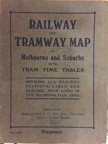
Map, Osboldstone & Co Pty Ltd, Railway and Tramway Map of Melbourne and Suburbs With Tram Timetables, 1917
... Kew Spur Line is also marked on the map. The Railway and Tramway Map of Melbourne and Suburbs With Tram Timetables is historically significant as it captures at a point in time, 1917, the development of public transport infrastructure in Melbourne. As such it illustrrates the theme: Connecting Victorians by transport and communications. railway maps -- melbourne (vic ...The Railway and Tramway Map of Melbourne and Suburbs With Tram Timetables lists existing Cable Tram Services before the entire network was electrified. By 1917 the tramways system was divided into regions including: the Melbourne Cable Tram Service; Prahran - Malvern Electric Trams; Hawthorn Electric Trams; Melbourne, Brunswick and Coburg Electric Trams; and Brighton Beach Electric Trams. The old Outer Circle railway line is marked as ending in Deepdene, with the remainder of the line to Fairfield marked as 'Unused'. The Kew tram along High Street in 1917 ended at the Harp Junction. The Kew Spur Line is also marked on the map.The Railway and Tramway Map of Melbourne and Suburbs With Tram Timetables is historically significant as it captures at a point in time, 1917, the development of public transport infrastructure in Melbourne. As such it illustrrates the theme: Connecting Victorians by transport and communications.Printed card-covered pocket sized map that folds out with three horizontal and vertical folds. Colour map, with scale, of the rail and tram networks on one side and sixteen sections of black and white printed text and timetable information on the reverse.railway maps -- melbourne (vic.), tramways maps -- melbourne (vic.), public transport -- melbourne (vic.) -- 1910-1920, cartography -
Kew Historical Society Inc
Archive (series) - Subject File, Kew Historical Society, 'Houghton', Princess Street, 1960
... kew (vic) mrs vasey obe kitty gahan annie bowden vasey newsletter Small archival file which includes histories of the weatherboard house, Houghton (erected 1853, now demolished), which once stood in Princess Street near Ivy Grange. The file includes a typescript of the chapter on Houghton by Dorothy Rogers published in ‘Lovely Old Homes of Kew’ (1960) and an undated document written by Louisa Hamilton which provides some information about the early history of Houghton but also records the development behind Houghton of 14 self-contained units for war widows. ...Various partiesReference, Research, InformationSecondary Values (KHS Imposed Order)Small subject file which includes histories of the weatherboard house, Houghton (erected 1853, now demolished), which once stood in Princess Street near Ivy Grange. The file includes a typescript of the chapter on Houghton by Dorothy Rogers published in ‘Lovely Old Homes of Kew’ (1960) and an undated document written by Louisa Hamilton which provides some information about the early history of Houghton but also records the development behind Houghton of 14 self-contained units for war widows. A Vasey newsletter (Circular No.144, August 1984) includes a quote from 1960 relating to the opening of the flats by Hon Hugh Robertson, Minister for Social Services.kew historical society - archives, kew - history, houghton - princess street - kew (vic), mrs vasey obe, kitty gahan, annie bowden, vasey newsletterkew historical society - archives, kew - history, houghton - princess street - kew (vic), mrs vasey obe, kitty gahan, annie bowden, vasey newsletter -
 Kew Historical Society Inc
Photograph - Photographs, Former Baptist Church, Woodlands Avenue, Kew East, 2018, 2018
... Kew's Civic History' (1960 writes that: "With the development of East Kew, local Baptists considered the establishment of a church was necessary. A block of land was purchased in Woodlands Avenue and the foundation stone of a new church was laid on August 8, 1931. A fine Sunday school has since been erected, and special emphasis has been given to providing activities for the young people of the church" churches - kew (vic ...The former Baptist Church, at 8-12 Woodlands Avenue, Kew East, was nominated by the Society for protection as part of the Kew East Heritage Gap Study. W D Vaughan in his 'Kew's Civic History' (1960 writes that: "With the development of East Kew, local Baptists considered the establishment of a church was necessary. A block of land was purchased in Woodlands Avenue and the foundation stone of a new church was laid on August 8, 1931. A fine Sunday school has since been erected, and special emphasis has been given to providing activities for the young people of the church"Three colour photographs of the former Baptist Church in Woodlands Avenue, Kew East. The photographs are of the front and side of the clinker brick building. One of the photographs shows the foundation stone, laid by AH Lewis Esq, 8 August 1931.churches - kew (vic), baptist church - woodlands avenue - kew (vic) -
Kew Historical Society Inc
Archive (collection) - Irena Higgins : Fol.1 Disability & Mental Health, 1951-2008
... Kew contain rare, and in a number of instances, unique handwritten or printed material relating to mental health and psychiatric treatment in Victoria in the second half of the Twentieth Century. They complement other major collections held by the Department of Health & Human Services (Victoria) and by the State Archives (PROV). They have particular significance due to their provenance as the personal papers of a significant actor in the development of trained social work in mental health institutions in Victoria. department of health (vic ...Irena Higgins (1951-2014) > Barbara Higgins (2015) > Kew Historical Society (2015)Professional papersCollection > Series > Sub-series (folder) > ItemKew Cottages: Introduction | Mental Retardation in Victoria: an historical perspective (1963) | Chronology of Kew Cottages | Kew Cottages Children's Training Centre | Work Evaluation Sheet for training purposes | History of Kew Cottages 1871-1986 | Kew Children's Cottages [booklet] | Social Work Department [including history of Children's Cottages] | Organising Playground Activities [letters] | Map of Kew Cottages | Role of the Social Worker [notes] | Notes for Student Groups (1968) [incl. reel-to-reel inside] | Annual Report for 1967 | Play Centre [letter] | Writing re Training of Children | Admission Procedure | 'Residential Care of the Retarded" (Seminar 1974) | Report on the Children's Cottages (1979) | Kew Cottages 1887-1987 Centenary Xmas Cardsdepartment of health (vic.), mental hygiene authority (vic.), mental health authority (vic.), health commission of victoria, community services victoria, department of health and community services, department of human services, kew cottages, kew children’s cottages, kew training centre, kew residential servicesdepartment of health (vic.), mental hygiene authority (vic.), mental health authority (vic.), health commission of victoria, community services victoria, department of health and community services, department of human services, kew cottages, kew children’s cottages, kew training centre, kew residential services -
Kew Historical Society Inc
Archive (collection) - Irena Higgins : Fol.3 Disability & Mental Health, 1951-2008
... Kew contain rare, and in a number of instances, unique handwritten or printed material relating to mental health and psychiatric treatment in Victoria in the second half of the Twentieth Century. They complement other major collections held by the Department of Health & Human Services (Victoria) and by the State Archives (PROV). They have particular significance due to their provenance as the personal papers of a significant actor in the development of trained social work in mental health institutions in Victoria. department of health (vic ...Irena Higgins (1951-2014) > Barbara Higgins (2015) > Kew Historical Society (2015)Professional papersCollection > Series > Sub-series (folder) > ItemSundry items: Sexuality and the law in Australia (People with an intellectual disability) | About your child who is Mongoloid (PH) | A study of Mongoloid Children (IH & PH) | A study of children with Mongolism need in the home compared to those reared away from the home | The intellectually handicapped child | Social history proforma | Intellectually handicapped children - education & training | Community Services and unmet community needs - a well rounded program for the retarded | Australia Citizen Ltd (magazine re mental retardation) | Aspects of rehabilitation 1964 (occupational therapy) | Need for a special unit for the assessment and treatment of intellectually disabled | Adolescents with social and or psychiatric problems | Training and recreational (activities of residents at Strathmont Centre) | The need of additional community facilities for intellectually handicapped children | Report - 1966? | The handicap of cerebral palsy.department of health (vic.), mental hygiene authority (vic.), mental health authority (vic.), health commission of victoria, community services victoria, department of health and community services, department of human services, kew cottages, kew children’s cottages, kew training centre, kew residential servicesdepartment of health (vic.), mental hygiene authority (vic.), mental health authority (vic.), health commission of victoria, community services victoria, department of health and community services, department of human services, kew cottages, kew children’s cottages, kew training centre, kew residential services -
Kew Historical Society Inc
Archive (collection) - Irena Higgins : Fol.4 Disability & Mental Health, 1951-2008
... Kew contain rare, and in a number of instances, unique handwritten or printed material relating to mental health and psychiatric treatment in Victoria in the second half of the Twentieth Century. They complement other major collections held by the Department of Health & Human Services (Victoria) and by the State Archives (PROV). They have particular significance due to their provenance as the personal papers of a significant actor in the development of trained social work in mental health institutions in Victoria. department of health (vic ...Irena Higgins (1951-2014) > Barbara Higgins (2015) > Kew Historical Society (2015)Professional papersCollection > Series > Sub-series (folder) > ItemWaiting Lists - Correspondence, referrals, reports at Cottages and Sunbury | Letter to Dr Brady | Letter from Dr Dax to Irena Higgins | Referrals | Waiting lists | Letter re centre in Colac | Interim Report on the Analysis of the waiting list for residential training centres of the Victorian Mental Health Authority | Some action taken | Sunbury waiting lists.department of health (vic.), mental hygiene authority (vic.), mental health authority (vic.), health commission of victoria, community services victoria, department of health and community services, department of human services, kew cottages, kew children’s cottages, kew training centre, kew residential servicesdepartment of health (vic.), mental hygiene authority (vic.), mental health authority (vic.), health commission of victoria, community services victoria, department of health and community services, department of human services, kew cottages, kew children’s cottages, kew training centre, kew residential services -
Kew Historical Society Inc
Archive (Sub-series) - Subject File, Kew Historical Society, North East Link, 2019
... Typically files will contain primary and secondary sources. north-east link transport infrastucure - kew (vic) roads - kew (vic) streets - kew (vic) freeways - kew (vic) Archive file containing documents relating to the development and impact of of North East link in Melbourne. ...Various partiesReference, Research, InformationSecondary Values (KHS Imposed Order)Subject file containing documents relating to the development and impact of of North East link in Melbourne.north-east link, transport infrastucure - kew (vic), roads - kew (vic), streets - kew (vic), freeways - kew (vic)north-east link, transport infrastucure - kew (vic), roads - kew (vic), streets - kew (vic), freeways - kew (vic) -
 Kew Historical Society Inc
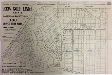
Plan - Subdivision Plan, Kew Golf Links Estate, 1936, 1936
... Kew. The site was at one stage designated for industrial development and the building of a new Kodak factory. The decision by Council to oppose the redevelopment makes the beginning of the period when all industrial development was banned in Kew. subdivision plans - kew (vic) kodak factory - kew (vic) Monochrome printed, folded subdivision plan for the Kew Golf Links Estate, to be auctioned on 7 November 1936. ...The Kew Golf Links Estate was a major subdivision in North Kew. It derived its title due to the land being previously occupied by the Kew Golf Club, which transferred its course to a number of locations before occupying its current site. The Plan advertises 180 choice home sites. The street names are somewhat different today as those on the map are named after the proposed Kodak Factory to be built on the site. The subdivision of the Kew Golf Links Estate was a major subdivision of farmland in Kew. The site was at one stage designated for industrial development and the building of a new Kodak factory. The decision by Council to oppose the redevelopment makes the beginning of the period when all industrial development was banned in Kew.Monochrome printed, folded subdivision plan for the Kew Golf Links Estate, to be auctioned on 7 November 1936. Streets named include: Carnegie Avenue, Willsmere Road, Kilby Boulevarde, Kodak Avenue, Coleman Avenue, Beresford Avenue, McConchie Avenue, Cole Avenue, White Avenue, Baker Avenue, Spruzen Avenue, Tanner Avenue, Ratten Avenue, Mathers Avenue, Railway Avenue, Sutherland Avenue, and Belford Road. The position of the Yarra River and a large Drainage Reserve are marked on the plan. Lots for sale are numbered. Existing buildings are designated with a square.subdivision plans - kew (vic), kodak factory - kew (vic) -
 Kew Historical Society Inc
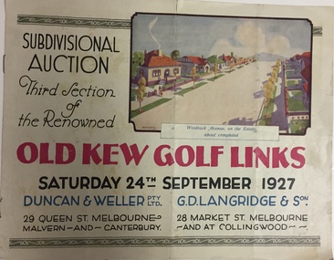
Booklet, Duncan & Weller Pty Ltd, Old Kew Golf Links Estate, 1927, 1927
... Kew. The site was at one stage designated for industrial development and the building of a new Kodak factory. The decision by Council to oppose the redevelopment makes the beginning of the period when all industrial development was banned in Kew. subdivisions - kew (vic) kew golf links estate 6 page illustrated brochure advertising the third section of a major subdivision in Kew in 1927 including 75 charming home allotments and 7 valuable building sites. ...The booklet advertises the third sale within the Old Golf Links Estate which was a major subdivision of farmland in North Kew in the 1920sThe subdivision of the Kew Golf Links Estate was a major subdivision of farmland in Kew. The site was at one stage designated for industrial development and the building of a new Kodak factory. The decision by Council to oppose the redevelopment makes the beginning of the period when all industrial development was banned in Kew.6 page illustrated brochure advertising the third section of a major subdivision in Kew in 1927 including 75 charming home allotments and 7 valuable building sites. The brochure includes the subdivision plan. The front cover includes a colour illustration of the almost completed houses in Woolcock Avenue. Streets named include: Kilby Road, Kodak Avenue, Baker Avenue, Mathers Avenue, Coleman Avenue, White Avenue and Belford Road. Lots for sale are numbered. Existing buildings are designated with a square.subdivisions - kew (vic), kew golf links estate -
 Kew Historical Society Inc
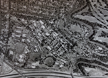
Photograph - Aerial Photograph, Aerial Photograph of Willsmere, circa 1980, c. 1980
... Kew Cottages, and doctors/clergy residences on the north side of Wills Street, before the State Government sold the land for residential development. The doctors residences in Wills street were made of 'Glen Iris' Olympic Bricks. According to neighbours of the time most of the buildings were demolished overnight in the 1980s. kew cottages eastern freeway willsmere yarra river aerial photographs -- kew (vic) kew boulevard Willsmere Mental Hospital kew mental hospital Kew Childrens Cottages Aerial photograph of Willsmere and the Kew Cottages bounded by the Boulevard, the Chandler Highway, Princess Street and Fellows Street. ...This aerial photograph shows the Kew Cottages, and doctors/clergy residences on the north side of Wills Street, before the State Government sold the land for residential development. The doctors residences in Wills street were made of 'Glen Iris' Olympic Bricks. According to neighbours of the time most of the buildings were demolished overnight in the 1980s.Aerial photograph of Willsmere and the Kew Cottages bounded by the Boulevard, the Chandler Highway, Princess Street and Fellows Street. The roundabout at the intersection of Princess Street, Wills Street, and Eglinton Street is at the top left. The Eastern Freeway is at the lower edge of the photograph.kew cottages, eastern freeway, willsmere, yarra river, aerial photographs -- kew (vic), kew boulevard, willsmere mental hospital, kew mental hospital, kew childrens cottages -
 Kew Historical Society Inc
Book, Agnes P Bell, Melbourne: John Batman’s Village, 1965
... Kew Historical Society, founded in 1958, has an extensive reference library, of which this book is a part. Volumes in the library are used by members for research into aspects of local history and/or to support the Society's collections of pictures, maps, fashion and artefacts. Reference books have entered the collection through donation, presentation, collection and purchase. The volume formed part of the professional library of the historian Dorothy Rogers. batman, john, 1801-1839 melbourne (vic.) -- history. settlement and contacts - colonisation - 1851- A history of Melbourne, tracing its development ...A history of Melbourne, tracing its development from the riverside village founded by John Batman to the metropolis of the 1960s; includes description of Aboriginal corroborees and other early encounters with the Aboriginal inhabitants of the area.Melbourne, Vic. : Cassell Australia, 1965 xiv, 178p. : ill. (some col.), facsims., map, porto. ; 25cm. non-fictionA history of Melbourne, tracing its development from the riverside village founded by John Batman to the metropolis of the 1960s; includes description of Aboriginal corroborees and other early encounters with the Aboriginal inhabitants of the area.batman, john, 1801-1839, melbourne (vic.) -- history., settlement and contacts - colonisation - 1851- -
 Kew Historical Society Inc
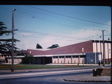
Photograph - Kew City Hall, Ron Setford
... development of road transport infrastructure during the 1970s with the construction of the Eastern Freeway. The photographer also took care to annotate and date most of his slides which enable the researcher to pinpoint temporal and spatial locations. Ron Setford Photographs -- Kew (Vic ...Ron Setford and his wife Grace Setford lived in Tanner Avenue, East Kew, from c.1946 to c.1995. A keen photographer, he recorded the changing face of Kew over a 20 year period. Apart from 30 photographs of built structures and places in Kew dating from 1960 and 1961, 145 of his 35mm colour slides chronicle the development of the Eastern Freeway through the Yarra Valley over a five year period from c.1972 to c.1977. This important collection was donated to the Society by his granddaughter in 2025.This collection of 175 35mm slides is of local and statewide significance, owing to its subject matter, particularly the major development of road transport infrastructure during the 1970s with the construction of the Eastern Freeway. The photographer also took care to annotate and date most of his slides which enable the researcher to pinpoint temporal and spatial locations.The Kew City Hall in Cotham Road, designed by Harold Bartlett, was intended as the initial phase in a scheme to develop an entire civic precinct. This was representative of a widely-held belief, of the immediate post-war era, that a district's civic centre should be precisely that – not just a single grand building for official use, but a dedicated precinct providing a range of community facilities as well as an administrative function. The Kew masterplan was later abandoned. The City Hall was designed to cater for public or official functions. Its interior had a small stage at one end for intimate theatrical productions, a larger stage at the other (with sunken orchestra pit) for musical performances, plus the most up-to-date equipment for live TV transmission.Nilron setford, photographs -- kew (vic.) -- 1960s -
 Kew Historical Society Inc
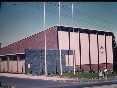
Photograph - Kew City Hall, Ron Setford, 1960
... development of road transport infrastructure during the 1970s with the construction of the Eastern Freeway. The photographer also took care to annotate and date most of his slides which enable the researcher to pinpoint temporal and spatial locations. Ron Setford Photographs -- Kew (Vic ...Ron Setford and his wife Grace Setford lived in Tanner Avenue, East Kew, from c.1946 to c.1995. A keen photographer, he recorded the changing face of Kew over a 20 year period. Apart from 30 photographs of built structures and places in Kew dating from 1960 and 1961, 145 of his 35mm colour slides chronicle the development of the Eastern Freeway through the Yarra Valley over a five year period from c.1972 to c.1977. This important collection was donated to the Society by his granddaughter in 2025.This collection of 175 35mm slides is of local and statewide significance, owing to its subject matter, particularly the major development of road transport infrastructure during the 1970s with the construction of the Eastern Freeway. The photographer also took care to annotate and date most of his slides which enable the researcher to pinpoint temporal and spatial locations.The Kew City Hall in Cotham Road, designed by Harold Bartlett, was intended as the initial phase in a scheme to develop an entire civic precinct. This was representative of a widely-held belief, of the immediate post-war era, that a district's civic centre should be precisely that – not just a single grand building for official use, but a dedicated precinct providing a range of community facilities as well as an administrative function. The Kew masterplan was later abandoned. The City Hall was designed to cater for public or official functions. Its interior had a small stage at one end for intimate theatrical productions, a larger stage at the other (with sunken orchestra pit) for musical performances, plus the most up-to-date equipment for live TV transmission."Kew Town Hall"ron setford, photographs -- kew (vic.) -- 1960s, kew town hall -
 Kew Historical Society Inc
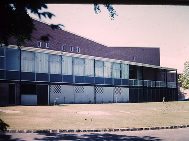
Photograph - Kew City Hall, Ron Setford, 1960
... development of road transport infrastructure during the 1970s with the construction of the Eastern Freeway. The photographer also took care to annotate and date most of his slides which enable the researcher to pinpoint temporal and spatial locations. Ron Setford Photographs -- Kew (Vic ...Ron Setford and his wife Grace Setford lived in Tanner Avenue, East Kew, from c.1946 to c.1995. A keen photographer, he recorded the changing face of Kew over a 20 year period. Apart from 30 photographs of built structures and places in Kew dating from 1960 and 1961, 145 of his 35mm colour slides chronicle the development of the Eastern Freeway through the Yarra Valley over a five year period from c.1972 to c.1977. This important collection was donated to the Society by his granddaughter in 2025.This collection of 175 35mm slides is of local and statewide significance, owing to its subject matter, particularly the major development of road transport infrastructure during the 1970s with the construction of the Eastern Freeway. The photographer also took care to annotate and date most of his slides which enable the researcher to pinpoint temporal and spatial locations.The Kew City Hall in Cotham Road, designed by Harold Bartlett, was intended as the initial phase in a scheme to develop an entire civic precinct. This was representative of a widely-held belief, of the immediate post-war era, that a district's civic centre should be precisely that – not just a single grand building for official use, but a dedicated precinct providing a range of community facilities as well as an administrative function. The Kew masterplan was later abandoned. The City Hall was designed to cater for public or official functions. Its interior had a small stage at one end for intimate theatrical productions, a larger stage at the other (with sunken orchestra pit) for musical performances, plus the most up-to-date equipment for live TV transmission.Nilron setford, photographs -- kew (vic.) -- 1960s, kew town hall -
 Kew Historical Society Inc
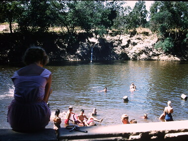
Photograph - Swimming in the Yarra River, Ron Setford, 1960-61
... development of road transport infrastructure during the 1970s with the construction of the Eastern Freeway. The photographer also took care to annotate and date most of his slides which enable the researcher to pinpoint temporal and spatial locations. Ron Setford Photographs -- Kew (Vic ...Ron Setford and his wife Grace Setford lived in Tanner Avenue, East Kew, from c.1946 to c.1995. A keen photographer, he recorded the changing face of Kew over a 20 year period. Apart from 30 photographs of built structures and places in Kew dating from 1960 and 1961, 145 of his 35mm colour slides chronicle the development of the Eastern Freeway through the Yarra Valley over a five year period from c.1972 to c.1977. This important collection was donated to the Society by his granddaughter in 2025.This collection of 175 35mm slides is of local and statewide significance, owing to its subject matter, particularly the major development of road transport infrastructure during the 1970s with the construction of the Eastern Freeway. The photographer also took care to annotate and date most of his slides which enable the researcher to pinpoint temporal and spatial locations.Nilron setford, photographs -- kew (vic.) -- 1960s, yarra river, recreation -- river swimming -
 Kew Historical Society Inc
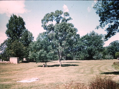
Photograph - Willsmere Park, Ron Setford, 1960
... development of road transport infrastructure during the 1970s with the construction of the Eastern Freeway. The photographer also took care to annotate and date most of his slides which enable the researcher to pinpoint temporal and spatial locations. Ron Setford Photographs -- Kew (Vic ...Ron Setford and his wife Grace Setford lived in Tanner Avenue, East Kew, from c.1946 to c.1995. A keen photographer, he recorded the changing face of Kew over a 20 year period. Apart from 30 photographs of built structures and places in Kew dating from 1960 and 1961, 145 of his 35mm colour slides chronicle the development of the Eastern Freeway through the Yarra Valley over a five year period from c.1972 to c.1977. This important collection was donated to the Society by his granddaughter in 2025.This collection of 175 35mm slides is of local and statewide significance, owing to its subject matter, particularly the major development of road transport infrastructure during the 1970s with the construction of the Eastern Freeway. The photographer also took care to annotate and date most of his slides which enable the researcher to pinpoint temporal and spatial locations.Nilron setford, photographs -- kew (vic.) -- 1960s, willsmere park -
 Kew Historical Society Inc
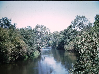
Photograph - Yarra River at Kew East, Ron Setford, 1960
... development of road transport infrastructure during the 1970s with the construction of the Eastern Freeway. The photographer also took care to annotate and date most of his slides which enable the researcher to pinpoint temporal and spatial locations. Ron Setford Photographs -- Kew (Vic ...Ron Setford and his wife Grace Setford lived in Tanner Avenue, East Kew, from c.1946 to c.1995. A keen photographer, he recorded the changing face of Kew over a 20 year period. Apart from 30 photographs of built structures and places in Kew dating from 1960 and 1961, 145 of his 35mm colour slides chronicle the development of the Eastern Freeway through the Yarra Valley over a five year period from c.1972 to c.1977. This important collection was donated to the Society by his granddaughter in 2025.This collection of 175 35mm slides is of local and statewide significance, owing to its subject matter, particularly the major development of road transport infrastructure during the 1970s with the construction of the Eastern Freeway. The photographer also took care to annotate and date most of his slides which enable the researcher to pinpoint temporal and spatial locations.Nilron setford, photographs -- kew (vic.) -- 1960s, yarra river -- kew east (vic.) -
 Kew Historical Society Inc
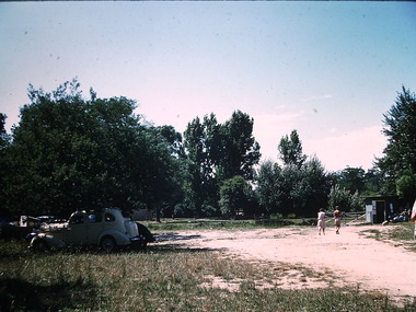
Photograph - Beach near Chipperfield's floating 'Pontoon', Ron Setford, 1960
... development of road transport infrastructure during the 1970s with the construction of the Eastern Freeway. The photographer also took care to annotate and date most of his slides which enable the researcher to pinpoint temporal and spatial locations. Ron Setford Photographs -- Kew (Vic ...Ron Setford and his wife Grace Setford lived in Tanner Avenue, East Kew, from c.1946 to c.1995. A keen photographer, he recorded the changing face of Kew over a 20 year period. Apart from 30 photographs of built structures and places in Kew dating from 1960 and 1961, 145 of his 35mm colour slides chronicle the development of the Eastern Freeway through the Yarra Valley over a five year period from c.1972 to c.1977. This important collection was donated to the Society by his granddaughter in 2025.This collection of 175 35mm slides is of local and statewide significance, owing to its subject matter, particularly the major development of road transport infrastructure during the 1970s with the construction of the Eastern Freeway. The photographer also took care to annotate and date most of his slides which enable the researcher to pinpoint temporal and spatial locations.Nilron setford, photographs -- kew (vic.) -- 1960s, yarra river -- kew east (vic.), chipperfield's boat house, chipperfield's floating pontoon