Showing 203 items matching "district of western port"
-
 Koorie Heritage Trust
Book, Baxter, Annie (1816-1905), Memories of Tasmania and of the Macleay River and New England districts of New South Wales and of Port Fairy in the western district of Port Phillip, 1834-1848, 1980
... Memories of Tasmania and of the Macleay River and New England districts of New South Wales and of Port Fairy in the western district of Port Phillip, 1834-1848...district of New South Wales or at Port Fairy in the Port Phillip district ...' `xii, 88 p. ; appendix; 33 cm. Memories of Tasmania and of the Macleay River and New England districts of New South Wales and of Port Fairy in the western district of Port Phillip, 1834-1848 Book Baxter, Annie (1816-1905) Sullivan's Cove ...They are the reminiscences of an English army officer's daughter who also was the wife of another such officer, and who by a chance of army life had become an antipodite. They cover the years between 1834, ... and 1848, ... They relate almost entirely to Australia, for she spent thirteen of those years either in Tasmania or in the Macleay River district of New South Wales or at Port Fairy in the Port Phillip district ...'`xii, 88 p. ; appendix; 33 cm.They are the reminiscences of an English army officer's daughter who also was the wife of another such officer, and who by a chance of army life had become an antipodite. They cover the years between 1834, ... and 1848, ... They relate almost entirely to Australia, for she spent thirteen of those years either in Tasmania or in the Macleay River district of New South Wales or at Port Fairy in the Port Phillip district ...'eastern australia. social life, 1834-1848. personal observations. | australia -- social life and customs. | australia -- history -- 1788-1900. | macleay river region (n.s.w.) -- history. -
 Whitehorse Historical Society Inc.
Administrative record - Crown Land Valuations and Applications, Government Printer - John FERRES, Crown Lands Pre-emptive Right Applications: Victoria 1850-1854, 1855
... District of Wimmera...District of Western Port...Applications relate to early settlement in the 1850's in Victoria CLARKE Andrew Anglesey Evelyn Bourke Dalhousie Dundas Follett Grant Hampden Heytesbury Normanby Polwarth Ripon Talbot Villiers District of Murray District of Wimmera District of Western Port Early Settlement Mornington Contains a valuation for Crown Lands applications under pre-emptive right by Victorian county, giving names of applicants name of run, area, and remarks. ...Contains a valuation for Crown Lands applications under pre-emptive right by Victorian county, giving names of applicants name of run, area, and remarks.Contains a valuation for Crown Lands applications under pre-emptive right by Victorian county, giving names of applicants name of run, area, and remarks. Contains a valuation for Crown Lands applications under pre-emptive right by Victorian county, giving names of applicants name of run, area, and remarks. clarke andrew, anglesey, evelyn, bourke, dalhousie, dundas, follett, grant, hampden, heytesbury, normanby, polwarth, ripon, talbot, villiers, district of murray, district of wimmera, district of western port, early settlement, mornington -
 Warrnambool and District Historical Society Inc.
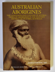
Book - Book of Early Western District Aboriginal Languages and Culture, Griffin Press Limited. South Australia, Australian Aborigines, 1981
... The book describes the customs, culture and day-to-day life of the aborigines living in the 19th century in the Western District (areas around Port Fairy, Warrnambool, Mortlake, and Camperdown) with ten dialects identified with these peoples. ...Warrnambool and District Historical Society Inc. 2 Gilles Street (south of Merri St) Warrnambool great-ocean-road This book is a facsimile of James Dawson's 1881 book, 'Australian Aborigines' published in 1981 100 years after the original book was written. The book describes the customs, culture and day-to-day life of the aborigines living in the 19th century in the Western District (areas around Port ...Description of Western District Aborigines and a dictionary of three of their languagesThis is a book of 112 pages of text plus 104 pages of aboriginal words and their meanings. The green cover has a gold image of an aboriginal hunter on the front cover and gold printing and a floral image on the spine. The pages contain printed text and some sepia-coloured photographs. non-fictionDescription of Western District Aborigines and a dictionary of three of their languagesjames dawson's book 'australian aborigines', western district aborigines 19th century -
 Bendigo Historical Society Inc.
Document - BUSH COLLECTION: EPHEMERA
... District Acts No 3437, 1925, 5 pages ; f. Scrapbook with cuttings from papers relating to Australia's history, scenery, flora and fauna, Farming, Industry, Rodeo, Horse Racing, Rural, Surf Life Saving, Religion, Federation, Explorers, Gold, Birds, - some loose cuttings in back; g. Land Tax Act, Schedule L 1910 (blank sheet); h. Commission of Public Health - three day tour of Western District (Warrnambool, port...District Acts No 3437, 1925, 5 pages ; f. Scrapbook with cuttings from papers relating to Australia's history, scenery, flora and fauna, Farming, Industry, Rodeo, Horse Racing, Rural, Surf Life Saving, Religion, Federation, Explorers, Gold, Birds, - some loose cuttings in back; g. Land Tax Act, Schedule L 1910 (blank sheet); h. Commission of Public Health - three day tour of Western District (Warrnambool, port ...Ephemera from Original Box 313; This is not a catalogued description of the contents but a broad-brush overall description. a. Book with 'Ledger' on cover; has newspaper cuttings re stage and screen on 8 of 94 pages (remaining, mostly blank); b. Gordon & Gotch - Sample Calendar No. 3 1935.( 61 cm x 50 cm) x2; c. Gordon & Gotch - Sample Calendar No. 2 (61 cm x 50 cm) x 2; d. Victorian Act of Parliament No 3041 (amending the Law relating to Public Health, 1919, 176 pages; e. Victorian Act of Parliament -(amending the Sewerage District Acts No 3437, 1925, 5 pages ; f. Scrapbook with cuttings from papers relating to Australia's history, scenery, flora and fauna, Farming, Industry, Rodeo, Horse Racing, Rural, Surf Life Saving, Religion, Federation, Explorers, Gold, Birds, - some loose cuttings in back; g. Land Tax Act, Schedule L 1910 (blank sheet); h. Commission of Public Health - three day tour of Western District (Warrnambool, port Fairy, Colac) from Melbourne; i. Collection of cuttings, envelopes; j. Newspapers - Argus, Advertiser pages late 1930s; (not scanned) k. Collection of newspaper cuttings; l. Collection of Public Health Regulations, 7 parts; m. Act of Parliament, Victoria No. 2632 - Law relating to Amendment of the Constitution; n. Folder containing issues of The Bendigo Church News, 25 parts 1930s-1950s; o. Collection of book lists/catalogues; p. AA (Automobile Association) Members Handbook 1963; q. Collection of varied sheets and pamphlets; r. Articles of Association - Ocean Salt Company; s.. Sydney Symphony Orchestra program 1953; t. Queen Mary's Message to the people, Jan 1936; u. various notices for display of historical items (BHS Collection)ephemera, mementoes -
 Warrnambool and District Historical Society Inc.
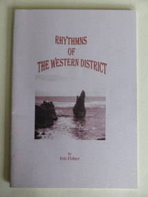
Booklet, Rhythmns of the Western District, 2003
... Port Fairy and Koroit. Iris Fisher wrote the poems when she was living in Allansford. She lived for 18 years in Warrnambool and seven in Allansford and is the author of four other books of verse that tell of her life and thoughts in the Western District of Victoria. ...District Historical Society Inc. 2 Gilles Street (south of Merri St) Warrnambool great-ocean-road This is a booklet of four poems about the Warrnambool area written and produced by Iris Fisher. The poems deal with aspects of Warrnambool, Allansford, Port Fairy and Koroit. Iris Fisher wrote the poems when she was living in Allansford. She lived for 18 years in Warrnambool and seven in Allansford and is the author of four other books of verse that tell of her life and thoughts in the Western ...This is a booklet of four poems about the Warrnambool area written and produced by Iris Fisher. The poems deal with aspects of Warrnambool, Allansford, Port Fairy and Koroit. Iris Fisher wrote the poems when she was living in Allansford. She lived for 18 years in Warrnambool and seven in Allansford and is the author of four other books of verse that tell of her life and thoughts in the Western District of Victoria. This book is of interest as it has been written by Iris Fisher who lived in the Warrnambool area for 25 years. The poems contain many references to the history of the four places – Warrnambool, Port Fairy, Koroit and Allansford. This is a small soft cover booklet of 26 pages. It has a mauve-coloured cover with an image of Childers Cove before the Sentinel rock was washed away. The cover printing is a dark red colour. The booklet contains four printed poems and black and white photographs of scenes and people of the Allansford/Warrnambool area. Mostly the illustrations are of an historic nature. The poems are dedicated to ‘Life in the Warrnambool Area’. The booklet is bound with staples.Front Cover: ‘Rhythmns (sic) of the Western District by Iris Fisher’ Inside front cover: ‘10/7/03 To Graeme and Barbara Best Wishes Iris’ allansford, port fairy, koroit, warrnambool, iris fisher -
 Warrnambool and District Historical Society Inc.
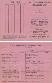
Document, VCFL Hampden District, Mid 20th century
... These cards are to be filled out by the timekeeper at football matches in the hampden district which covers the area from Colac to Port Fairy in Western Victoria. ...Warrnambool and District Historical Society Inc. 2 Gilles Street (south of Merri St) Warrnambool great-ocean-road These cards are to be filled out by the timekeeper at football matches in the hampden district which covers the area from Colac to Port Fairy in Western Victoria. ...These cards are to be filled out by the timekeeper at football matches in the hampden district which covers the area from Colac to Port Fairy in Western Victoria. The form has space to record the various aspects of time matters for each football game. A common but essential part of the running of sports .Both cards are identical and are bright pink with black text in table form on front and back. V C F L Hampden Districtwarrnambool,, hampden league, hampden district, timekeepers vcfl -
 Warrnambool and District Historical Society Inc.
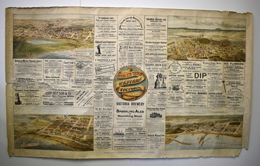
Poster - Print and Lithograph of Western Victorian towns and businesses, McCarron Bird & Co, Birds Eye Views in Western Victoria, c. 1900
... Port Fairy, Portland and Hamilton and a great number of advertisements and illustrations, some from Melbourne and the rest from the Westen District towns mentioned above. One Warrnambool advertisement is for the general merchant business of William Caffin in Kepler Street and two others are advertisements for the coastal ships, Flinders, Dawn and Casino which came into the port of Warrnambool. This poster has local historical significance as it has a descriptive drawing of the town of Warrnambool about 1900 and shows the buildings that were existing at that time. Warrnambool 1900 Western ...This poster has been produced as a saleable item by the firm of McCarron Bird & Co of Melbourne about 1900. This firm was founded in 1872 and is best known for its publication of the two-volume work, 'Victoria and its Metropolis' (1888). The poster was intended to be hung on a wall for decorative and advertising purposes. It contains four attractive lithographs of the towns, Warrnambool, Port Fairy, Portland and Hamilton and a great number of advertisements and illustrations, some from Melbourne and the rest from the Westen District towns mentioned above. One Warrnambool advertisement is for the general merchant business of William Caffin in Kepler Street and two others are advertisements for the coastal ships, Flinders, Dawn and Casino which came into the port of Warrnambool. This poster has local historical significance as it has a descriptive drawing of the town of Warrnambool about 1900 and shows the buildings that were existing at that time.This is a cream-coloured sheet of paper with a coloured centre piece showing the title of the poster, four coloured lithographs of Western Victorian towns and advertisements printed and illustrated in black and white. The edges of the poster are frayed and the paper is torn at the centre left edge.warrnambool 1900, western victorian towns 1900, william caffin general merchant warrnambool -
Warrnambool and District Historical Society Inc.
Booklet - Regional Tourist Guide, W. Payne, Western Districts Illustrated Guide, c. 1914
... Western District. It dates from about 1914 and includes advertisements, text and black and white photographs of the towns of Warrnambool, Camperdown, Port Fairy, Koroit, Colac and Lorne. ...Warrnambool and District Historical Society Inc. 2 Gilles Street (south of Merri St) Warrnambool great-ocean-road This booklet has been produced by a Melbourne publisher as a tourist guide to the Western District. It dates from about 1914 and includes advertisements, text and black and white photographs of the towns of Warrnambool, Camperdown, Port Fairy, Koroit, Colac and Lorne. ...Regional Tourist Guide with photographs and textThis is a small booklet of 32 pages. The cream-coloured cover contains an ornamental border, four black and white photographs and black printing. The pages contain advertisements, black and white photographs and printed text. The booklet has been stapled but the staples have been removed. non-fictionRegional Tourist Guide with photographs and textwestern district of victoria, warrnambool tourism, early 20th century tourist guides -
 Warrnambool and District Historical Society Inc.
Booklet, The Dublin spelling book, 1844
... Warrnambool and District Historical Society Inc. 2 Gilles Street (south of Merri St) Warrnambool great-ocean-road This book, an Irish spelling book with a strong religious tone, is in a very tattered state but has the name ‘Freckleton’ on it and it may have come with the first Freckleton immigrants to Australia. In the 19th century there were Freckleton families in the Warrnambool district at Port Fairy, Cooramook, Mailors Flat, Woolsthorpe, Woodford and Wangoom. The provenance of this book is unclear but it is kept because of its early printing (1844) and because of its association with the Freckleton families. freckleton families, western ...This book, an Irish spelling book with a strong religious tone, is in a very tattered state but has the name ‘Freckleton’ on it and it may have come with the first Freckleton immigrants to Australia. In the 19th century there were Freckleton families in the Warrnambool district at Port Fairy, Cooramook, Mailors Flat, Woolsthorpe, Woodford and Wangoom. The provenance of this book is unclear but it is kept because of its early printing (1844) and because of its association with the Freckleton families. This is a soft cover book of 240 pages. The cloth cover is brown with no visible markings on the front cover or spine. The pages are bound together with string and the material on the spine is almost worn away. Some of the pages are torn and very dirty and all are dog-eared. There is a grey and white illustration on the first page. The inscriptions on the first and second pages, barely legible, are handwritten in pencil and in black ink. ‘W. Freckleton, landed (?) 1857….1875….1888’ ‘…May landeth….’ freckleton families, western district, history of warrnambool -
 Warrnambool and District Historical Society Inc.
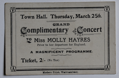
Card - Concert Ticket, Modern Print, Warrnambool, Complimentary Concert, 1926
... Port Fairy. She received local funding to enable her to study at the Melbourne Conservatorium of Music under Madame Weiderman and toured the Western District in 1926, supported by the pianist May Broderick and the violinist Cecil Parkes, in a series of complimentary concerts to give her funding to study in Europe. ...District Historical Society Inc. 2 Gilles Street (south of Merri St) Warrnambool great-ocean-road This is a ticket for a complimentary concert to the Victorian soprano, Miss Mollie Hayres, in the Warrnambool Town Hall in 1926. Inez Mary (Mollie) Hayres (1897-1980) was born in Port Fairy and received her early musical training from the Good Samaritan Sisters in Port Fairy. She received local funding to enable her to study at the Melbourne Conservatorium of Music under Madame Weiderman and toured the Western ...This is a ticket for a complimentary concert to the Victorian soprano, Miss Mollie Hayres, in the Warrnambool Town Hall in 1926. Inez Mary (Mollie) Hayres (1897-1980) was born in Port Fairy and received her early musical training from the Good Samaritan Sisters in Port Fairy. She received local funding to enable her to study at the Melbourne Conservatorium of Music under Madame Weiderman and toured the Western District in 1926, supported by the pianist May Broderick and the violinist Cecil Parkes, in a series of complimentary concerts to give her funding to study in Europe. She became a well-known singer and singing teacher in Melbourne, featuring in radio programs and concerts. This ticket is of interest as a memento of Mollie Hayres, a noted singer in Victoria in the first half of the 20th century.This is a small white card with black edging and printing. Grand Complimentary Concert to Miss Mollie Hayresmollie hayres soprano, good samaritan sisters port fairy -
 Warrnambool and District Historical Society Inc.
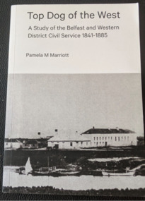
Book, Pam Marriott (publisher), Top Dog of the West, 2017
... Western District Civil Service 1841-1886’. It contains information on the police, police magistrates, court officials, customs and immigration officials etc who lived and worked in the Port Fairy and Warrnambool districts in the 19th century and many of the incidents and events with which they were connected. ...Warrnambool and District Historical Society Inc. 2 Gilles Street (south of Merri St) Warrnambool great-ocean-road This book, written by Pam Marriott, is subtitled ‘A Study of the Belfast and Western District Civil Service 1841-1886’. It contains information on the police, police magistrates, court officials, customs and immigration officials etc who lived and worked in the Port Fairy and Warrnambool districts in the 19th century and many of the incidents and events with which they were connected. ...This book, written by Pam Marriott, is subtitled ‘A Study of the Belfast and Western District Civil Service 1841-1886’. It contains information on the police, police magistrates, court officials, customs and immigration officials etc who lived and worked in the Port Fairy and Warrnambool districts in the 19th century and many of the incidents and events with which they were connected. The book includes much information that is relevant to Warrnambool’s past. This book is an important acquisition to the Warrnambool & District Historical Society library as it contains information on many 19th century Warrnambool personalities, including policemen and court officials. It also has detailed information on some events that occurred in the Warrnambool district in the 19th century. This is a soft cover book of 480 pages. The cover and spine are white, with a black and white photograph and black printing. The pages include an introduction, eleven chapters of printed material, an index, a bibliography and appendices. There are several black and white photographs, plans, maps and other illustrative material. western district 19th century history, western district civil service 19th century, history of warrnambool -
 Warrnambool and District Historical Society Inc.
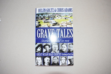
Book, Grave Tales, 2017
... Of particular interest to Warrnambool and district readers are the documented lives of Jack Denham of the La Bella shipwreck, early Warrnambool settlers, Agnes and James Ruttleton, William Sharrock, hero of the Nestor sinking, the Rutledge brothers and the Mills brothers of Port Fairy, the scientist Frank Burnet, the unionist William McLean, Dick the bushranger and Captain Pye, V.C. This book is of interest as it gives information on a variety of historical figures buried in cemeteries in the Great Ocean Road districts (Geelong to Port Fairy). It will be useful to researchers. western ...This book details the lives of some people of the past who are buried in cemeteries along the Great Ocean Road. Of particular interest to Warrnambool and district readers are the documented lives of Jack Denham of the La Bella shipwreck, early Warrnambool settlers, Agnes and James Ruttleton, William Sharrock, hero of the Nestor sinking, the Rutledge brothers and the Mills brothers of Port Fairy, the scientist Frank Burnet, the unionist William McLean, Dick the bushranger and Captain Pye, V.C. This book is of interest as it gives information on a variety of historical figures buried in cemeteries in the Great Ocean Road districts (Geelong to Port Fairy). It will be useful to researchers. This is a soft cover book of 290 pages. It has black and white and coloured photographs on the front and back covers and printing on the spine and back and front covers. The pages contain an introduction, 22 chapters, black and white photographs and maps and illustrations. western district of victoria, warrnambool, jack denham, agnes ruttleton, william sharrock, rutledge brothers, mills brothers, frank burnet, william mclean -
 Warrnambool and District Historical Society Inc.
Documents, Letters to Sliding Gunter, 1902
... Port Fairy. He moved to Warrnambool and commenced work as secretary to the Western Steam Navigation Company becoming manager in 1883. After the company failed he joined with Mark Saltau and they traded as Saltau and Osborne. His writings as Sliding Gunter appeared in The Warrnambool Standard and the Belfast Gazette. He was knowlegable and maintained an interest in shipping and the sea. He died in 11th December 1902 and his body was taken on board the Julia Percy and was buried at sea out from the Breakwater. He was well liked in the district...District Historical Society Inc. 2 Gilles Street (south of Merri St) Warrnambool great-ocean-road Sliding Gunter was the nom de Plume of Thomas Hamilton Tracey Osborne. Thomas Hamilton Tracey Osborne was born at Belfast 4/9/1851, the son of Thomas Hamilton Trail Osborne and his second wife Eliza nee Treacey. The young Thomas spent many hours among seamen and ships at Port Fairy. He moved to Warrnambool and commenced work as secretary to the Western ...Sliding Gunter was the nom de Plume of Thomas Hamilton Tracey Osborne. Thomas Hamilton Tracey Osborne was born at Belfast 4/9/1851, the son of Thomas Hamilton Trail Osborne and his second wife Eliza nee Treacey. The young Thomas spent many hours among seamen and ships at Port Fairy. He moved to Warrnambool and commenced work as secretary to the Western Steam Navigation Company becoming manager in 1883. After the company failed he joined with Mark Saltau and they traded as Saltau and Osborne. His writings as Sliding Gunter appeared in The Warrnambool Standard and the Belfast Gazette. He was knowlegable and maintained an interest in shipping and the sea. He died in 11th December 1902 and his body was taken on board the Julia Percy and was buried at sea out from the Breakwater. He was well liked in the district and people lined the Cannon Hill area and the foreshore to farewell him. As an avid writer he corresponded with many people and this letter is one such letter The writer J J Crawford from Koroit tells the story of some of his family and their travels to Australia and early years in South Australia. The contents of letters such as these show he drew information from various sources.These letters as they relate to one of Warrnambool's earliest writers hold historic and social significance.002192.1 Plain white paper letter handwritten in black ink on back and front of letter 002192.2 Plain white paper letter handwritten in black ink on front and section on the back written sideways. Both letters are in the same hand.002192.1 dated 27 Feb 1902, Koroit. Signed J J Crawford 002192.2 Dated 1 March 1902, Koroit.sliding gunter -
 Warrnambool and District Historical Society Inc.
Document, Letter to Mr J H Osborne 1901, 1901
... Warrnambool and District Historical Society Inc. 2 Gilles Street (south of Merri St) Warrnambool great-ocean-road Thomas Hamilton Tracey Osborne was born at Belfast 4/9/1851, the son of Thomas Hamilton Trail Osborne and his second wife Eliza nee Treacey. The young Thomas spent many hours among seamen and ships at Port Fairy. He moved to Warrnambool and commenced work as secretary to the Western ...Thomas Hamilton Tracey Osborne was born at Belfast 4/9/1851, the son of Thomas Hamilton Trail Osborne and his second wife Eliza nee Treacey. The young Thomas spent many hours among seamen and ships at Port Fairy. He moved to Warrnambool and commenced work as secretary to the Western Steam Navigation Company becoming manager in 1883. After the company failed he joined with Mark Saltau and they traded as Saltau and Osborne. His other main interest was writing some of which he did under the nom de plume of Sliding Gunter. These articles appeared in The Warrnambool Standard and the Belfast Gazette. He was knowlegable and maintained an interest in shipping and the sea. He died in 11th December 1902 and his body was taken on board the Julia Percy and was buried at sea out from the Breakwater. He was well liked in the district and people lined the Cannon Hill area and the foreshore to farewell him. As an avid writer he corresponded with many people and this letter is one such letter. It relates to recollections of the wreck of the Maria in 1840 out of Adelaide and the loss of life which followed. Unfortunately the letter is incomplete.This letter is of interest as it is addressed to one of Warrnambool's interesting people at the turn of the 20th century. Thomas Hamilton Tracey Osborne has left a legacy of much written work which records aspects of Warrnambool's history as well as his interest in ships and seafaring. This letter shows he drew his information from various sources.One lined page of a letter written in black pen. A wide margin on the left side of the page . The back is blank.The letter is addressed to Mr T H Osborne. Date November 30th 1901.thomas hamilton tracey osborne, western steam navigation company, saltau and osborne, 1901 letter, wreck of the maria 1840 -
 Warrnambool and District Historical Society Inc.
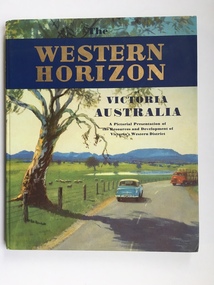
Book, Western Horizon, C 1960
... western District of Victoria. It explores various aspects of the Western District such as water supply,architecture,ports,produce,and agriculture. ...Warrnambool and District Historical Society Inc. 2 Gilles Street (south of Merri St) Warrnambool great-ocean-road This book presents a pictorial history of the western District of Victoria. It explores various aspects of the Western District such as water supply,architecture,ports ...This book presents a pictorial history of the western District of Victoria. It explores various aspects of the Western District such as water supply,architecture,ports,produce,and agriculture. It also presents the various scenic spots around the district. The publishers of this book , the Australian publicity Council is dedicated to publicising the state of Victoria and its natural resources in an effort to attract overseas investment and industry.This book provides a snapshot of the Western District in the 1960 's both with the information and the photographs contained within, including some which were taken by Ralph Illidge who was one on Warrnambool's best known photographers. Coloured hard board cover with country scene with road with two vehicles on a road which continues to the back cover.. A large gum tree sits beside the road. The title is gold on a navy blue banner. Thereis a small blurb on the back cover. 112 pages.Australian Publicity Council. Henry Bolte Premier of Victoria.history of warrnambool, western horizon, western victoria, ralph illidge, warrnambool 1960's -
 Warrnambool and District Historical Society Inc.
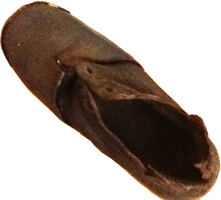
Footwear - Child's boot, 1940s
... This small shoe (or boot) was found at Rosebrook, a small settlement between Warrnambool and Port Fairy, after the 1946 Western District floods. These floods are regarded as the worst in the history of European settlement in the Western District. ...Warrnambool and District Historical Society Inc. 2 Gilles Street (south of Merri St) Warrnambool great-ocean-road This small shoe (or boot) was found at Rosebrook, a small settlement between Warrnambool and Port Fairy, after the 1946 Western District floods. ...This small shoe (or boot) was found at Rosebrook, a small settlement between Warrnambool and Port Fairy, after the 1946 Western District floods. These floods are regarded as the worst in the history of European settlement in the Western District. At least five lives were lost, many small settlements and towns were isolated resulting in food shortages, onion and potato crops were ruined, 20 bridges were destroyed or damaged, roads were swept away, hundreds of farm animals perished and road and rail services were disrupted. The floods were the result of a very high rainfall in five successive days (658 points of rain in one 24 hours) and there was more flooding a week after the first major impact of the rains. A link to a major weather event in the South west.This is a small child’s brown shoe made of leather with a lace-up upper part (no laces) and a leather sole. The sides of the upper part of the shoe have broken away at the edges. As the shoe has been water-logged (it was found after the 1946 Western District floods) it has become hard and brittle. warrnambool, rosebrook western district floods, 1946, 1940's shoe -
 Warrnambool and District Historical Society Inc.
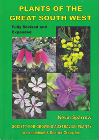
Book, Star Printing Terang Victoria. 978-0-9751360-1-0, Plants of the Great South West 2013 Second Edition, 2013
... Warrnambool and District Historical Society Inc. 2 Gilles Street (south of Merri St) Warrnambool great-ocean-road Second edition (revised a& expanded edition) First edition 2004. Guide to the indigenous plants of South West Victoria. South West Victoria: Nelson – Port Campbell. Zone A.B.C & D. Local maps Bioregions plantsof western ...Second edition (revised a& expanded edition) First edition 2004. Guide to the indigenous plants of South West Victoria. South West Victoria: Nelson – Port Campbell. Zone A.B.C & D. Local maps BioregionsCard cover green) gloss white paper. End papers. Map 1&2. 6 pages credits, title, table of contents, forward, acknowledgements, disclaimer, websites. 348 pages. Colour maps & photographs. References & reading. Index plantsof western victoria, kevin sparrow, warrnambool -
 Warrnambool and District Historical Society Inc.
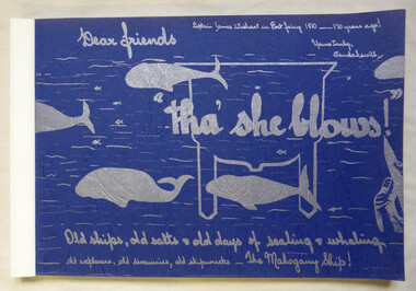
Book, Vanda Savill (1913-2005), Tha' she blows, 1980
... This book is of some interest as it details the early history of the areas of Port Fairy and Portland and includes the story of the Mahogany Ship which is a topic of interest to many today. The handwritten material is also of interest as an example of Vanda Savill’s work in compiling local Western District history. whaling port fairy portland shipwrecks Scrapbook style book history of early Port Fairy and Portland Front cover: Captain James Wishart in Port Fairy – 170 years ago! ...Scrapbook style book history of early Port Fairy and PortlandThis is a paper back book of 176 pages. The pages are bound together. The cover is blue card with silver-coloured wording and illustrations of whales. There are 829 photographs and illustrations. The historical material contained in the pages is handwritten and photocopied. non-fictionScrapbook style book history of early Port Fairy and Portlandwhaling, port fairy, portland, shipwrecks -
 Warrnambool and District Historical Society Inc.
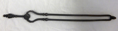
Tool - Fireside implements, 000190.1 Shovel : 000190.2 Tongs
... Initial court cases for the Western district were held and controlled for some time by Rutledge in Port Fairy. ...Warrnambool and District Historical Society Inc. 2 Gilles Street (south of Merri St) Warrnambool great-ocean-road Initial court cases for the Western district were held and controlled for some time by Rutledge in Port Fairy. ...Initial court cases for the Western district were held and controlled for some time by Rutledge in Port Fairy. The first courthouse was built around 1854 and was in service until the stone building was built next to it in 1870. These two implements were used until around 1970 when heating was installed in the courthouse. They were decommissioned by Mr Ellis Roberts, Public Works Department Inspector.These implements have a strong connection to a public building which has a long association with the town and surrounding area. The courthouse of 1863 was the scene of an infamous murder of Constable O’Boyle in front of the fireplace. Shovel has barley sugar twisted handle with eight sided domed top. It is flared at the bottom to hold the spade which is attached with two metal rivets. Spade contains a number of holes cut into oval shape in centre and has fluted side edges. The tongs consist of two parts held together below a short handle with a metal rivet and two metal discs. Both pieces have decorative mouldings on the handles and remnants of black paint. warrnambool courthouse, fire tongs, fire shovel, fire spade, warrnambool -
 Warrnambool and District Historical Society Inc.
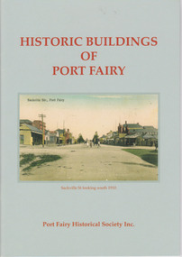
Booklet, Port Fairy Historical Society, Historic Buildings of Port Fairy, 2012
... Warrnambool and District Historical Society Inc. 2 Gilles Street (south of Merri St) Warrnambool great-ocean-road Port Fairy, a small town in Western Victoria established in 1836, has an exceptional collection of public buildings and dwellings dating from the 1840s. ...Port Fairy, a small town in Western Victoria established in 1836, has an exceptional collection of public buildings and dwellings dating from the 1840s. This booklet gives short descriptions of 58 of these historic buildings, many with accompanying photographs. These include many buildings in Gipps and Sackville Streets, the Powder Magazine, some hotels, the Drill Hall, Dublin House, the Port Fairy Cemetery and several schools and churches. This booklet is useful for those seeking quick information on the historic buildings in Port Fairy and for those wanting to undertake a walk around the town’s historic spots. TryBooking will show you the full breakdown on the Booking Payment Report and the Event Revenue Itemised Report so you can clearly see the ticket sales, credit card processing fee and the funds that are yours. Front cover: ‘Historic Buildings of Port Fairy, Port Fairy Historical Society Inc.’ Photograph on front cover: ‘Sackville Str. Port Fairy’, ‘Sackville St. looking south 1910’ Back cover map: ‘Port Fairy Historic Buildings’ warrnambool, port fairy, western victoria, historic buildings -
 Warrnambool and District Historical Society Inc.
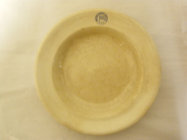
Plate (Belfast & Koroit S.N. Co.), Late 1920s
... Warrnambool and District Historical Society Inc. 2 Gilles Street (south of Merri St) Warrnambool great-ocean-road This plate was made by the Calyx Porcelain and Paint Company which was based in Western Australia and made china for commercial establishments from the 1920s to the 1990s when the company was then known as Australian Fine China. The plate was used by the Belfast and Koroit Steam Navigation Company based in Port ...This plate was made by the Calyx Porcelain and Paint Company which was based in Western Australia and made china for commercial establishments from the 1920s to the 1990s when the company was then known as Australian Fine China. The plate was used by the Belfast and Koroit Steam Navigation Company based in Port Fairy. It was founded in 1882 and operated two ships, the Casino and the Bellinger, servicing the Western Ports between Melbourne and Portland. The Casino was wrecked at Apollo Bay in 1932. Later the company operated the ship, Dawn and survived as a shipping company until the late 1930s.This plate is of interest because it was used by the Belfast and Koroit Steam Navigation Company in the 1920s and 30s. This company was important in the maritime history of Warrnambool, especially in the transportation of potatoes from the Warrnambool region. The Casino, the most important ship operated by the Belfast and Koroit Steam Navigation Company, was also important as a passenger and cargo ship prominent in Warrnambool’s maritime historyThis is a circular-shaped cream soup bowl or dinner plate. On the edge of the plate there is a blue embedded stamp in the shape of a circle with the flag of the steamship company inside. On the base of the plate is the maker’s information in green print. The base of the plate is much crazed and discoloured‘Belfast & Koroit S.N. Co. Ltd.’ ‘Made in Australia, Calyx, W.A.’ belfast & koroit steam navigation company, history of warrnambool -
 Warrnambool and District Historical Society Inc.
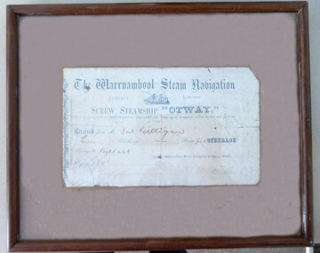
Document - Receipt: Warrnambool Steam Navigation Company
... Warrnambool and District Historical Society Inc. 2 Gilles Street (south of Merri St) Warrnambool great-ocean-road This is a passenger ticket for the Screw Steamship "Otway".It was built in 1872 at Glasgow for the Warrnambool Steam Packet Company. She traded to and from the Western Ports ...This is a passenger ticket for the Screw Steamship "Otway".It was built in 1872 at Glasgow for the Warrnambool Steam Packet Company. She traded to and from the Western Ports until 1878.when she was sold for the Melbourne West Australian trade. She was broken up at Sydney in 1924. The Warrnambool Steam Packet Company commenced in 1868 and operated on the Western Ports run using the ships "Edina", "Rob Roy", "Otway", " Nelson" and "Julia Percy".In 1878 it became the Western Steam Navigation Company which operated until 1896. There is no information available on the passenger James Gilligan This item which may come from the old Warrnambool Museum is of considerable interest as a rare memento of steam travel to and from the Western Ports in the 19th century. Warrnambool was an important port at that time and this item is part of our marine history. This is a receipt for a passenger's ticket to travel to Belfast ( Port Fairy) on the Screw Steamship "Otway" in 1875. It is pasted on a brown background and enclosed in a glass covered brown wooden frame.There is string at the back for hanging the item. The Warrnambool Steam Navigation Company Limited Received from Jas Gilligan Ten Shillings for a steerage passage to Belfast 1875ship "otway", warrnambool, warrnambool steam navigation company -
 Warrnambool and District Historical Society Inc.
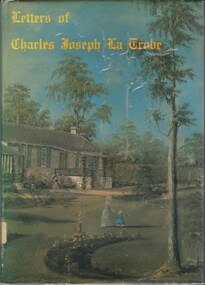
Book, Letters of Charles Joseph La Trobe, 1975
... Port Phillip district in 1837. He was described as a man with a serious mind and highly talented in many different fields. This book contains a variety of letters which he wrote in the period 1840 through to 1870 to a number of different people including a number to his wife. Charles La Trobe was an important administrator in the early days of Victoria. This collection of letters provide an insight into his personal thoughts and the extent of his interests. The Western ...Correspondence from Charles Joseph La Trobe written between 1840 and 1870.Blue and green toned coloured dust cover over blue hard cover. Picture depicts house with woman and child and large tree in foreground. Covered in clear plastic. 96 pages. Title is in old style yellow lettering. The book contains a number of colour plates and black and white illustrations.Correspondence from Charles Joseph La Trobe written between 1840 and 1870.charles la trobe, letters of charles joseph la trobe, early victoria -
 Warrnambool and District Historical Society Inc.
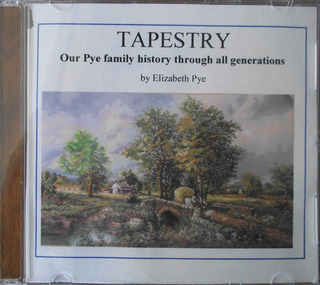
Audio - Audio CD, Tapestry: our Pye family history through all generations, Early 21st century
... Thomas Pye came to Sydney as convict in 1837 and was assigned to work for Captain Sylvester Brown and came to the Port Philip district with his master. Sylvester's son, Thomas, travelled to the Western District in 1844 and took Thomas and his wife. ...District Historical Society Inc. 2 Gilles Street (south of Merri St) Warrnambool great-ocean-road This DVD gives information about the Pye family. Thomas Pye came to Sydney as convict in 1837 and was assigned to work for Captain Sylvester Brown and came to the Port Philip district with his master. Sylvester's son, Thomas, travelled to the Western ...This DVD gives information about the Pye family. Thomas Pye came to Sydney as convict in 1837 and was assigned to work for Captain Sylvester Brown and came to the Port Philip district with his master. Sylvester's son, Thomas, travelled to the Western District in 1844 and took Thomas and his wife. Mary with him. Thomas Browne later wrote novels under the name of Rolf Boldrewood . In his book " Old Melbourne Memories " Thomas Pye is given the name Joe Burge. Thomas Browne established the property "Squattlesea Mere" and Thomas Pye and his family settled in Port Fairy and then in Bessiebelle. Today this little settlement has many Pye descendants. The other matter of interest is that Thomas Pye's son,Charles Pye, gained the Victoria Cross in India and is buried at Tower Hill. his DVD is of historical interest because it records the story of the Pye family in the Western District.This is a DVD with blue hand writing on the front and an accompanying sheet of paper showing an English country scene. It is enclosed in a plastic mesh envelope.TAPESTRY Our Pye Family history through all generations by Elizabeth Pye.pye family, warrnambool, captain sylvester brown, thomas browne, rolf boldrewood -
 Warrnambool and District Historical Society Inc.
Letter, Hand written copy National Bank V A Bostock, Circa 1900
... Western District. They owned and leased various properties around Warrnambool and were involved in many aspects of social and business life. The document itself is indicative of its time and provides an insight into the details and terms of such documents at the time. warrnambool, bostock, national bank, klingender, o’mahony, murray, malleson england and stewart,1900, Klingender, O’Mahony & Murray Solicitors at Warrnambool, Koroit, Port Fairy, Terang and Mortlake. ...Augustus Bostock was the 9th child of Robert & Rachael Bostock of Vaucluse Epping Forest, Van Diemen’s Land. He was only 4 years old when his mother died. He was inspired by his father to seek his fortune in the Western District of Victoria. He arrived around 1850. He married Margaret Aitkin in July 1865. Augustus owned several properties in the district and leased others. He sat on the court of Warrnambool, Mortlake or Hexham as required. He resided at Marramook in Hawkesdale and later moved to Vaucluse in Hopetoun Road Warrnambool, where he died in 1920 at the age of 87. He was involved in many aspects of life in the Western District, racing, cricket, and social activities to name a few. This letter shows correspondence between the two firms of solicitors and is demanding payment of £500.00 as settlement by Bostock, to the National Bank. This is one of a number of documents which relate to the Bostock family who were one of the most important pioneering families of the Western District. They owned and leased various properties around Warrnambool and were involved in many aspects of social and business life. The document itself is indicative of its time and provides an insight into the details and terms of such documents at the time.Cream lined paper, with Solicitors letterhead printed in top left corner. Letter is hand written in black ink. Watermarked Cowan Extra strongKlingender, O’Mahony & Murray Solicitors at Warrnambool, Koroit, Port Fairy, Terang and Mortlake. Telephone No. 51. The letter has come from Malleson, England & Stewart of Melbourne. Watermarked Cowan Extra Strongwarrnambool, bostock, national bank, klingender, o’mahony, murray, malleson england and stewart,1900, -
 Christ Church Anglican Parish of Warrnambool
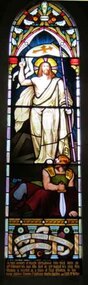
Memorial window: Eliza RUTLEDGE
... The marriage of Eliza to William Rutledge, a man of historical importance in the development of Port Fairy, Warrnambool and the western district of Victoria, places her as a person of importance.Her daughter Susan Fleetwood is also memorialised in a window in Christ Church, Warrnambool.Her son, Thomas Forster is memorialised in a tablet near the two windows for Eliza. rutledge christ church warrnambool eliza rutledge eliza kirk farnham park In fond memory of ELIZA RUTLEDGE who was born on / 12th February AD 1820, who died on 31st August AD 1888, this / window is erected as a token of filial affection by her / loving children Thomas F Rutledge, Martha Hamilton and Edith McKellar. ...Eliza Rutledge (1820-1888) was the daughter of Rupert and Jane (nee Newby) Kirk. She married William Rutledge in St James’ Church, Sydney on 18th August, 1840. She and William had five children two sons and five daughters. Recorded accounts tell that Eliza was “beloved for her kindness and hospitality” and that she and William kept open house for all manner of social events and occasions. Eliza died at Farnham Park, Dennington, on 31st August 1888. The marriage of Eliza to William Rutledge, a man of historical importance in the development of Port Fairy, Warrnambool and the western district of Victoria, places her as a person of importance.Her daughter Susan Fleetwood is also memorialised in a window in Christ Church, Warrnambool.Her son, Thomas Forster is memorialised in a tablet near the two windows for Eliza.Stained-glass lancet window, south wall, main nave. A depiction of the risen Jesus.In fond memory of ELIZA RUTLEDGE who was born on / 12th February AD 1820, who died on 31st August AD 1888, this / window is erected as a token of filial affection by her / loving children Thomas F Rutledge, Martha Hamilton and Edith McKellar.rutledge, christ church warrnambool, eliza rutledge, eliza kirk, farnham park -
 Christ Church Anglican Parish of Warrnambool
Memorial window: Elizae (Eliza) RUTLEDGE, "By Thy Glorious Ascension Good Lord Deliver Us"
... The marriage of Eliza to William Rutledge, a man of historical importance in the development of Port Fairy, Warrnambool and the western district of Victoria, places her as a person of importance.Their daughter Susan Fleetwood is also memorialised in a window in Christ Church, Warrnambool. ...Eliza Rutledge (1820-1888) was the daughter of Rupert and Jane (nee Newby) Kirk. She married William Rutledge in St James’ Church, Sydney on 18th August, 1840. She and William had five children, two sons and five daughters. Recorded accounts tell that Eliza was “beloved for her kindness and hospitality” and that she and William kept open house for all manner of social events and occasions. Eliza died at Farnham Park, Dennington, on 31st August 1888. She is buried at Tower Hill Cemetery. The marriage of Eliza to William Rutledge, a man of historical importance in the development of Port Fairy, Warrnambool and the western district of Victoria, places her as a person of importance.Their daughter Susan Fleetwood is also memorialised in a window in Christ Church, Warrnambool. Their son Thomas Forster is also memorialised with a tablet positioned near the Eliza Rutledge windows. Stained glass, lancet window, south wall, main nave. Depiction of the ascension of Christ."By Thy Glorious Ascension Good Lord Deliver Us" In Latin: +In Memoriam+ Elizae Rutledge quae pridie idus Februarias/ MDCCXX nata pridie kalendas Septembres MDCCCXXXVIII obit/ liberi amantissimi Gulielmus Rutledge et Susanna Fleetwood pietatis/ indicio hane Jenestram posuerant Beati qui sunt mundi corde.rutledge, christ church warrnambool, eliza rutledge, eliza kirk, farnham park -
Federation University Historical Collection
Document, Zelda Martin, Central Victorian Goldmining towns - Boom Towns or Ghost Towns?, c1996
... Port Phillip District" +"Langi Ghiran 1: Aboriginal Rock...." +"Koorie History: sources for aboriginal studies in the State Library of Victoria", ed. Tom Griffiths, Melb. Friends of the State Library, 1989 +"The Public Lands of Australia Felix"; settlement and land appraisal in Victoria1834-91 with special reference to the Western Plains", J.M.Powell, Melb. ...Port Phillip District" +"Langi Ghiran 1: Aboriginal Rock...." +"Koorie History: sources for aboriginal studies in the State Library of Victoria", ed. Tom Griffiths, Melb. Friends of the State Library, 1989 +"The Public Lands of Australia Felix"; settlement and land appraisal in Victoria1834-91 with special reference to the Western Plains", J.M.Powell, Melb. ...Zelda Martin was a PhD candidate at the University of Melbourne.[.1] 4th item in light blue display book titled Research Approach/Overview of Chapters/Confirmation of Canditure/Chapters1,2,3&4 of proposed thesis. *Twenty-seven page article on Victorian goldfields towns titled: Central Victorian Goldmining Towns - Boom Towns or Ghost Towns. The article was written during the author's PhD study. It outlines the context methodology, and resources and the chapters of the proposed thesis: (1) Central Victorian Goldmining Towns - The Context (2) Contemporary Views of the Factors Necessary for Town Growth (3) Outward Manifestations of Town Growth (4) The Trappings of Government (5-9) The Main Towns and Their Hinterland. [.2] 5th item in Light Blue display book as above item. *Chapter 1 of proposed thesis titled 'Pick, Shovel and Tin Dish Mining.' Covers in Section A: Central Victoria - Pre 1851: Aborigines in Central Victoria, Squatters, and Government. Section B: The years 1851-1854: The Early Gold Rushes, Government Reaction, Township Surveys, Legislation, Town Development, Local Government and Early Settlement. [.3] 6th item in Light Blue display book as above item. *2A of proposed thesis titled 'Contemporary Views of the Factors Necessary for Town Growth'. Similar information to Chapter 1 plus extra re towns and maps. Sections: Introduction, Context of Place - Geographical Towns Listed, The Context of Time - Pre1851 Aborigines, Governance of Port Phillip, The Squatters, The Villages of Central Victorian Highlands, Conclusion, Condensed Version of Chapter2B. [.4] 7th item in Light Blue display book as above item. *Chapter2B of proposed thesis. Sections: Area of Research, Schools, Banks, Newspapers, Progress Association, Town Development - Sandhurst (Bendigo), Ballarat, Castlemaine,, Maryborough, Ararat and Stawell. [.5] 8th item in Light Blue display book as above item. *Chapter 3 of proposed thesis titled 'Outward Manifestations of Town Growth'. Sections: Introduction, Contemporary Writing, Educationalists, The Bankers, The Townsfolk, Current Theory, General Theories of Urban Development, and Conclusion. [.6] 9th item in Light Blue display book as above item. *Chapter 4 of proposed thesis titled 'Trappings of Government' Sections: Introduction, Early Government Attitudes to Mining and Town Development, Law and Order, Township Surveys, Legislation, Local Government, Transport and Communication, The People and Lobbyists. [.7] 10th item in Light Blue display book as above item. *'The Rise and Fall of Central Victorian Goldmining Towns'. Includes a map showing main Goldfields, a table showing towns and villages at two points in time - 1857 and 1871; a Bibliography of Primary and Secondary Sources. [.8] Resource No1. Black display book titled Local Towns 1 : Alma: *Brief history *Directory *Maps Amphitheatre / Mountain Hut: *Brief History Post Office Directory Ararat: *Brief History *Post Office Directory 1869 - Alphabetical Listing by Occupation *Ararat - Prominent Citizens of 1858 *Langi-Morgala Museum Avoca: *Brief History *Excerpts from 'Avoca The Early Years', Margery and Betty Beavis; pg1 - Beginnings; pg11 - The Midas Touch; pg25 - Local Gold Escorts; pg27 - A Town is Born; pg51- The Administration of Justice; pg53 - The Ways of the Law; pg61 - News of the Day; pg65 - A Time to Play; pg72 - Land Ownership *Post Office Directory (Bailliere's) 1869 *Tourism Map and Information of area *Historic Avoca - A 5.5km Tour *Avoca & the Pyrenees Region - information pamphlet Ballarat: *Early History of Ballarat - Ballarat Historical Society, Publication No.1: origin of the name; Ballaarat - the Beginning; Fabulous Yields from the Ballaarat Goldfield; *Streetscape Lydiard Street. *Hand drawn map showing Leigh River, Old Portland Bay Road, plaque on road to Colac; etc. *Newspaper article re 'The Theatre Royal' ( which stood in the vicinity of the current Owen Williams store) - 'The News'15/04/1998 *Article - 'Ballarat's Mechanics' Institute Lives On' Ballarat Courier, 14/09/1985 *Article - Standing the Test of Time' The News 17/11/1993 re The Mechanics Institute & picture of the Reading Room *'Ballarat a Study of a City, Phyllis Reichl, pub. Nelson, 1968; no.3 place, time and people field studies series *Investigator Vol.33 No.2, 1998 Geelong Historical Society. Article on pg75 describes Ballarat in 1861 *Folded poster - 'Ballarat 100' a history of telegraph communication, pub. Telecom. Beaufort (Fiery Creek): *Brief history *Post Office Directory [.9] Resource No.2 Black Folder Titled Towns cont.No2 Bendigo (Sandhurst): *'Family & Local History at the Bendigo Library - 1851-2001 150 years of gold'. *Bendigo Government Camp in 1853 illustration; key to sketch and names of Government officers stationed there *Excerpts from 'Bendigo and Vicinity' Adolph Haman *The Bendigo Goldfield Registry - pgs 1-7 Introduction *Excerpt: 'Breaking the Grip' *Excerpt: The Most Go-Ahead Place *Excerpts from 'History of Bendigo' - anti license agitation; laying out of town; proposed railway; gold calls and dividends; the Sandhurst Municipality; journalism *Bibliography Blackwood: *Excerpts from 'Aspects of Early Blackwood - The Goldfield, the Landmarks, the Pioneers' Alan J Buckingham and Margaret F Hitchcock, JG Publishing,1980 Buninyong: *A Brief History *Investigator Vol1 No.2 Feb 1966 Geelong Historical Society. Pg3 - Article re gold escort route - Mt Alexander to Adelaide - (see a simple monument on the Western Highway a few miles out of Horsham. Pg 15 - Ballarat Excursion - re the finding of gold. *Three articles published by Buninyong and District Historical Society Inc: (Magpie Exploration; Finding Gold In The Green Hills; Magpie Exploration; Burnt Bridge to Cargarie to Mt Mercer) *Copies of newspaper articles/items *Buninyong Street Directory Carisbrook: *In the Beginning There Was Carisbrook *The History of the Carisbrook Racecourse Carngham / Snake Valley: *Brief History *Directory Castlemaine: *Directory 1865-1866 - Alphabetical and Street *Poster - Castlemaine A Contemporary Guide "The Great Centre" 1866 - A Contemporary Guide to the Fascinating Past *Pamphlet - Castlemaine District Community Hospital *Map - Castlemaine, Maldon & Surrounding Districts *Map and Information - The Dry Diggings Track - a 55kl walk among historic goldfields relics ( Castlemaine Fryerstown Vaughan Mt Franklin Hepburn Daylesford) *Postcard - Former Court House *Directory 1867 - Alphabetical, Trade [.10] Resource No.3 Grey folder Titled Towns 3 Creswick to Maryborough Creswick: *Brief History *Booklet - "Creswick Cemetery Walk" *Booklet - The Buried Rivers of Gold Heritage Trail Creswick *Creswick Historical Museum Information Sheet *Chronological History of Creswick *Alphabetical Directory of the Borough of Creswick *Creswick's Creek Directory 1856 *Historic Creswick Walking Tour *A Brief Account of the Schools of Creswick - Past and Present *100 Years of Railway Travel in Creswick *The Berry Deep Leads *The Spence Home at Jackass Gully in the Creswick State Forest ( William Guthrie Spence - Pioneer) *The New Australian Mine and the 1882 Disaster *Creswick District News, Issue 7, July August 1999 *The Creswick Miners Walk - Information and Map *Maps Chewton: *Brief History *Directory Clunes: *Brief History *Clunes Street Directory Daylesford: *Brief History *Notable Bushfires in Daylesford District Over More Than a Century - "Black Thursday" 1851; 1862; 1899; the Disastrous Hepburn Fire of 1906; 1939; 1944; 1969. *Post Office Directory -Daylesford and Hepburn Dunolly / Inkerman: *Brief History *Directory *Pamphlet - Goldfields Historical Museum *Pamphlet - Historic Dunolly - Victoria's Best Kept Secret *Map of Gold Workings at Dunolly Area - showing where the main gold rushes occurred *Brief History - Inglewood *Directory - Inglewood - Name Occupation, Dwelling Kingower: *Brief History *Directory - Name / Ocupation / Dwelling Linton / Happy Valley / Piggoreet: *Brief History *Directory - Lintons McIvor: *"A History of the Shire and the Township of Heathcote" by J.O. Randell Majorca: *Brief History *Official Post Office Directory 1869 - Name / Occupation/ Address Maldon (Tarrangower): *Brief History Part 1 *Brief History Part 2 *Post Office Directory *List - Alphabetical Order by Names plus Business and Trade (Tarrangower Times Oct/1858) *List - Alphabetical Order by Trade plus Name and Business *Directory - Name / Occupation / Dwelling Maryborough: *Worsley Cottage - built by Arthur Worsley, a contractor in stonework in 1894 [.11] Resource No. 4 Blue Display Book titled Towns 4 Moliagul to Stawell Moliagul: *Brief History *Moligul Legislative Assembly (Voting?) List - Names and Occupations *Moliagul Victorian Post Office Directory 1868 - Name / Ocupation / Address / Comments *"The Welcome Stranger" gold nugget *The Sunday School *The Welcome Stranger Discovery Walk - information and map Moonambel (Mountain Creek) Redbank *Brief History *List of names extracted from advertisments of the Pioneer and Mountain Creek Advertiser 16/02/1861. *Bailliere's Directory 1869 - Alphabetical List of Name / Occupation / Place St Arnaud: *Brief History Sebastapol: *Brief History *Directory 1869 - Alphabetical by Name; plus occupation and address. Browns and Scarsdale: *Brief History *Browns Street Directory - Name and Occupation Smythesdale: *Brief Description *Smythesdale Street Directory -Name and Occupation Stawell (Pleasant Creek) *Brief History *Victorian Official Post Office Directory - Name /Occupation / Dwelling *Chronology - 1841-1920 *Production of gold statistics - 1879 - 1900 *Big Hill *Extracts from "The Golden Years of Stawell". Chapt 1 - Stawell's Coming Out. Capt. 2 - The Gold Rush. Caapt.3 - Cradle of Democracy. Chapt.4 - The Reefs Becomes Stawell. Chapt. 5 - Rushing In. Chapt.6 - The Pioneers. Chapt 7 - The Decade of Optimism. [.12] Resource No. 5: Blue Display Book titled 'Towns Steiglitz to the The Golden Triangle. Steiglitz: Brief History Victorian Post Office Directory 1869 *Map of Steiglitz *List of maps relevant to Steiglitz history *Information 6 tables of data from "Reports of Mining Surveyors Talbot (Back Creek) Brief History Taradale: Post office Directory 1869 - Name/Occupation/Street. Also list in alphabetical order by Occupation Taradale *Chronological Reference to Taradale Mines *Water - The Coliban System of Waterworks *Joseph Brady *The Syphon Tarnagulla (Sandy Creek) *Brief History *Tarnagulla Businessmen Cameos to give depth to advertisments in 'The Tarnagulla Courier' various issues 1864-1871 *Directory - Name/Occupation /Address *List - Name/Business/Trade Wedderburn (Koorong) *Brief History *List - Name/Occupation The Golden Triangle: *The Early Rushes - Wedderburn / Moliagul / Sandy Creek - Tarnagulla / Jones Creek - Waanyarra / Kingower / Dunolly - Goldsborough / Inglweood *Census of 1857 - Population / Occupations *1858-1871 - A Time of Consolidation- Wedderburn / Moliagul / Sandy Creek- Tarnagulla / Arnold *Census 1871 - Population *Information gleaned from the census data - Demographics / Population / Occupations / marital / Birthplace / Religion / Literacy/ Occupation and Housing Cameos *Graphs - Birthplace of settlers /Male-Female Ratio / Married males / Children under 15 as Percentage of Population / Religion *Census 1857 - Statistical data *Maps *Bibliography [.13] Resource No. 6 - Black Display Book Information and Research in Central Victoria including: *Banking - Research from ANZ Bank Archives *Institutions - also includes articles listed from the Ballarat Times Newspaper *Australian mining History Association - A.M.H.A. Bibliography *Australia's Mining History * Bibliography - Land Surveys Victoria - *1853 Administration (Statistics and Other) includes: schools / ministers of religion / police / military / local administration / licences for sale of spirits / distances between various Victorian gold fields. * Victoria Government Gazette (Copy) - N0. 116, 12/12/1854 includes: Gold Felds Commission of Enquiry & No. 85, 15/09/1854 - Addresses presented to the Lieutenant Governor (Sir Charles Hotham) during his tour through the Gold Fields of Victoria,1854. Addresses on behalf of : the people of Bendigo; Members of the Church of England, Bendigo; Members of the Wesleyan Church on the Bendigo Gold Fields; Bendigo Gold District General Hospital; the Bendigo Prospecting Association; Committee of the Bendigo Local Exhibition; Bendigo District Medical Association; Coloured Americans Resident at Bendigo; German Inhabitants of Bendigo; Landowners, Inhabitants, and Miners of Castlemaine; Inhabitants of Forest Creek; Inhabitants of Heathcote and Gold Miners of McIvor; Residents and landholders of the District of Bacchus Marsh; Inhabitants of Kilmore and Vicinity. *Gold Fields Correspondence 1853: letter from Lieutenant Colonel Valiant, (Officer commanding the Troops in Victoria) to the Lieutenant Governor re threatened disturbance at Sandhurst (Bendigo) regarding the Gold License Fee. * Extracts from a book "Victoria" re Gold Fields Commission of Enquiry involving mainly Ballarat and Castlemaine and a chapter titled 'A Tour to the Victorian Gold-Fields' *Lists of central Victorian newspapers - listed by date published 1851to 1874; by first date available to State Library. *A list of cities and towns showing County, population in 1861 &1871, and municipal status. [.14] Resource no.7. Black display book. *Reference: Papers presented to Parliament Victoria - 1859-1860 4 volumes - relevant sections copied. Contains information on Branches of Government. General / Finance / Gold / Gazette / Commission and Warrant / Statistic. *Gold Fields Act. In accordance with the Act the gold fields are divided into six districts - Ballaarat, Castlemaine , Sandhurst, Avoca, Ararat, and Beechworth.. Official staff in each gold district consists of a Resident Warden, Wardens, Wardens' Clerks, Bailiffs, Chinese Protectors, Chinese Interpreters, and Mining Surveyors. *Gold Receiver *Gaols *Police magistrates and Clerks of Petty Sessions, etc. *Field Branch *Immigration and Emigration Overland - Chinese - 1859 *Population on the Goldfields *The Geological Survey - The Government Geologist is assisited by staff from four branches - the office Branch; the Publishing Branch; the Field Branch and the Museum Branch. *Commission to Enquire Into Sludge dated 10/02/1859 (Some sections copied) - Report to the Honorable Chief Commissioner of Public Works, Melbourne re the mode of carrying the sludge from the puddling mills in Sandhurst without interfering with the drainage of the town and the roads in the neighbourhood. [.15] Resource No.8: Camel display book titled Resource No. 8. Aborigines *Lists of book titles - +"Readings in Victorian prehistory" +"The Aborigines of Port Phillip" +Aboriginal languages and clans" +"A History of the Port Phillip District" +"Langi Ghiran 1: Aboriginal Rock...." +"Koorie History: sources for aboriginal studies in the State Library of Victoria", ed. Tom Griffiths, Melb. Friends of the State Library, 1989 +"The Public Lands of Australia Felix"; settlement and land appraisal in Victoria1834-91 with special reference to the Western Plains", J.M.Powell, Melb. Oxford University Press 1970 +*Bibliography of the Victorian Aborigines' from the earliest manuscripts to 31st December 1970, Massoa, Aldo, Melb. Hawthorn Press, 1971 +"Aborigines in Colonial Victoria, 1836-1886", M.F. Christie, Sydney University Press, 1979 +"Urban and Industrial Australia: readings in Human Geography" ed J.M. Powell, Melb. Sorrett Pub. 1974 *Extracts: -Processes of Pioneer Settlement - The Squatting Occupation of Victoria, 1834-60. J.M. Powell -Areal Variations in the Class Structure of the Central-Place Hierarchy. P. Scott - Volume1 and Volume 2: Notes Relating to the Habits of the Natives of Other Parts of Australia and Tasmania. Compiled from various sources for the Government of Victoria by R Brough Smyth. John Curry, O'Neil, Melb. 1st pub. Melb. 1876. p31-45 - Numbers and Distribution of the Aborigines in Victoria -Victorian Aborigines 1835-1901 - A Resource Guide to the Holdings of the Public Record Office, Victoria; published by the Government Information Centre 1984. *History of the Aboriginal Artefacts Displayed in the Daylesford Museum. F. G. Powell (4 page pamphlet) *Letter to Zelda Martin from Peter Lovett, Cultural Officer, Ballarat & District Aboriginal Co- Operative, 05/02/1997 *Map: Ian Clarke Victorian Tribunal Boundary Map - Clans of Central Victoria. *Victorian Rock Art and Mythology - Article about Mount Langhi Ghiran and myths of the Tjapwarong people. *Two Aboriginal myths relating to the Grampians - 'The Monster Emu' / 'The Aquisition of Fire', by the Aborigines in the Grampians Areas *Article titled (chapter 8) Ballarat - information re camping sites in the region. Lake Wendouree / Lake Burrumbeet (includes a myth) / Mt Bunninyong / Lal Lal / Pitfield / Mount Elephant / Mount Egerton / Meredith / Lake Goldsmith / Lake Learmonth / Ercildoune *Notes on the Aborigines of the Wider Ballarat Region plus European names=Aboriginal names. John Morris 26/07/1995 *Role of Aborigines in Town Development in Central Victoria. Mentions Native Police Force est. in Port Phillip 1842 and Central Board for Aborigines est. 1860 *The Grave of King Billy. (Frank Wilson) Pamphlet. *Camping Places in Central and Northern Victoria. Article re Lake Burrumbeet site. *Programme for the Unveiling of Memorial Cairn for Edward Stone Parker 1802-1865. Note portrait not accurate. Accurate portrait is available in the book "A Successful Failure A Trilogy The Aborigines and Early Settlers", Edgar Morrison, Graffiti Publications, 2002. * Large envelope addressed to Mr G Netherway containing newspaper cuttings regarding the life of Edward Stone Parker, the unveiling of the Memorial Cairn as mentioned above, articles titled 'Episodes from Our Early Days' (Edgar Morrison, Yandoit)- The Black's School, A School At Last and The Final years. Also a typed page titled 'Historical Background to E.S.Parker's Career. Includes an interesting tale titled 'When the cat lay doggo' re laying power leads for the unveiling ceremony at the memorial site. [.16] green display folder titled 'Research Aids' *List of references to Commissioners' & W'ardens' Reports (formerly held at La Trobe Library Archives, now at Public Records Office [PRO]). Indicates town referred to / date of report / name of camp if different to town. * Archive information re Anglican Records *Movement around the Goldfields - Miners and Storekeepers - usefulness of newspapers in providing information - areas covered - Castlemaine, Maldon, Ararat, Stawell, Tarnagulla, Dunolly. *Port Phillip /Victoria Directories 1839/1867 - Chronological list of Directories included in this series. *"Notes on the History of Local Government in Victoria" A.W. Greig Melb. University Press 1925 - Photo-copied extract p5-p40. (Source - Deakin University Library) - Introduction by W.Harrison Moore. Section 1 - Development in New South Wales Before Separation. Section 2 - Development in Victoria After Its Separation from New South Wales. Hand written notations: 'roads, markets, and local government 1855 on' ;'opportunity of squatters in parliament' and 'opportunities of matters in parliament p33' * Notes on the Establishment of Surveyor General's Department 1851and Commissioner of Crown Lands and Survey. * Newspaper articles from The Argus, 1849, re the discovery of gold in the Pyrenees region. * Excerpt - a report on schools - A.B.Orlebar, Inspector; re the need for permanent school buildings rather than tents. *Excerpt from - 'Approaches to Urban History', Sean Glynn: The Case for Caution * Except from - 'The Urban Sprinkle', Weston Bate: Country Towns and Australian Regional History *Reference- 'The History of Land Tenure in the Colony of Victoria', John Quick. References the Haines Land Bill, land tenure and Land Leagues. [.17] Light blue envelope folder titled 'Birtchnell's Ballarat, etc. Directory 1862 *Contains various directories for Smythesdale, Buninyong, Clunes, Brown's and Creswick. [.18] Red envelope folder no.2 titled Victorian Gazetteer *Selected pages from 1869 Victorian Gazetteer on A4 paper (with a handwritten note questioning if some pages are from 1868 Victorian Gazetteer as appears to be different sizes - A3 pages.) Information includes locations and descriptions of towns, hotels, banks, communications and populations. (Does not include names, residences and occupations) [.19] Red Envelope folder titled Bailliere's Official Post Office Directory 1868 (or1869 or a mixture of both?) *Preface *Contains a selection of pages of towns highlighted in yellow in the the index *Work on this directory was commenced in 1867. *Information includes: Municipalities - mayors and councilors; lists of towns naming male inhabitants and their occupations. [.20]Yellow manila folder titled Post Grad Seminar Presentation 1996 *Gives some background to Zelda Martin's proposed thesis and why she chose the topic Gold Mining Towns Boom or Bust [.21] A3 display book - No. 1A * A list of 'Relevant Newspapers collected: The Tarrangower Times and Maldon Advertiser (first published 1858) Includes dates 1858-1867. The Mount Alexander Mail. Includes dates 1854-1866 The Tarnagulla Courier. Includes dates from1864-1871 Dunolly and Burnt Creek Express. Includes dates from 1862-1871 * Selection of newspaper pages from The Mount Alexander Mail 1854 to 1856, mostly showing advertisements for businesses and services provided to that community. [.22] A3 display book - No. 1B * Selection of newspaper pages from The Mount Alexander Mail 1857 to 1866, mostly showing advertisements for businesses and services provided to that community. [.23] A3 display book -No. 2 * Selection of newspaper pages from The Tarnagulla Courier 1864 to 1871, mostly showing advertisements for businesses and services provided to that community. [.24] A3 display book - No. 3 *Selection of newspaper pages from The Tarrangower Times (and Maldon and Newstead) Advertiser 1858 to1867, mostly showing advertisements for businesses and services provided to that community. [.25] A3 display book - No.4 * Selection of newspaper pages from The Dunolly and Burnt Creek Express; and The Dunolly and Betbetshire Express 1862 to 1871, mostly showing advertisements for businesses and services provided for that community. [.26] A3 display book - No.5 Includes: * Bryce Ross's Diggings Directory. Includes instructions for using this directory. This directory was used by "all persons having connexion or desiring to communicate with 'working parties, private friends, or Stores at the Diggings." As a directory for each area wwas completed it was published in each month's issue of Bonwick's "Digger's Magazine." Years c1852/1853. This Directory commences first at the head of Forest Creek. Includes a directory for Bendigo and Ballarat. Of interest at the end of the Bendigo and Ballarat directory is a list of the number of storekeepers, butchers, doctors, smiths, eating houses, lemonade sellers and chapels. * The Castlemaine Directory and Book of General Information Comprehending Glass's Model Calendar for the Two Years 1862 and1863. "zelda martin, victorian goldfield towns, bendigo, castlemaine, ballarat, maldon, stawell, ararat, maryborough, creswick, avoca, heathcote, banks, bank of australasia, union bank of australia, government camp, sandhurst, water supply, tarnagulla, talbot, back creek, mountain creek, police court, carisbrook, dunolly, thompson's foundry, charles clacy, anthony trollope, robert cecil, mount alexander, urbanisation, national schools, education, govenrment, industry, railway, transport, settlement, land settlement in central victoria, steiglitz, joseph brady, the new australian mine, berry deep leads, william guthrie spence, creswick state forest, arthur worsley, worsley cottage, the welcome stranger, moliagul, moonambel, redbank, st arnaud, sebastapol, brown's, scarsdale, clunes, chewton, daylesford, bushfires, inkerman, inglewood, kingower, lintons, happy valley, piggoreet, mcivor, majorca, tarrangower, taradale, the coliban system, the syphon, sandy creek, wedderburn, koorong, arnold, jones creek, waanyarra, the golden triangle, census 1857, blackwood, buninyong, durham lead, magpie, carngham, snake valley, alma, amherst, daisy hill, amphitheatre, mountain hut, beaufort, fiery creek, counties, population, gold fields commission of enquiry1854, william westgarth, gold license fee, lieutenant colonel valiant, administration of the victorian gold fields, commission to enquire into sludge 1859, e.s. parker, edward stone parker, edgar morrison, mount franklin protectorate, dja dja wurrung, memorial cairn, franklinford, mt franklin memorial cairn, jajowurrong, dja dja wurung, tjaowarong, wothowurong, assistant protectors, daylesford museum, buluk, rock art - grampians, aboriginal mythology - grampians, aborigines, first nations people, mount franklin, aboriginal artifacts, lake burrumbeet, native police force, central board of aborigines, yandoit, commissioners' reports, wardens' reports, port phillip/victoria directories 1839-1867, local government - victoria 1853/1854, surveyor general's department - 1850's, victorian schools 1850's, a.b.orlebar, haines land bill, william charles haines, wilson gray, land tenure, land leagues, victorian gazetteer, the tarrangower times and maldon advertiser - 1858-1867, the mount alexander mail 1854-1866, the tarnagulla courier 1864, dunolly and burnt creek express 1862-1871, bryce rose's diggings directory, the castlemaine directory 1862-1863 -
 Eltham District Historical Society Inc
Photograph - Aerial Photograph, Landata, Eltham; Crown Allotment 15, Section 5, Parish of Nillumbik (Stokes Orchard Estate), Feb. 1979
... Eltham District Historical Society Inc 728 Main Rd Eltham melbourne Centred on present day Diosma Rd, Stokes Pl, Nyora Rd and Eucalyptus Rd Historic Aerial Imagery Source: Landata.vic.gov.au Aerial Photo Details: Project No :1716 Project : WESTERN PORT FORESHORES Run : 15 Frame : 91 Date : 02/1979 Film Type : B/W Camera : RC8 Flying Height : 5500 Scale : 10000 Film Number : 3286 GDA2020 : 37°42'47"S, 145°09'57"E MGA2020 : 338339, 5824447 (55) Melways : 22 C4 (ed. 42) A History of the Development of Crown Allotment 15, Section 5, Parish of Nillumbik – Stokes Orchard Crown Allotment 15, Section 5, Parish of Nillumbik (CA15) is a square allotment of 158 acres or approximately a quarter of a square mile. ...Centred on present day Diosma Rd, Stokes Pl, Nyora Rd and Eucalyptus Rd Historic Aerial Imagery Source: Landata.vic.gov.au Aerial Photo Details: Project No :1716 Project : WESTERN PORT FORESHORES Run : 15 Frame : 91 Date : 02/1979 Film Type : B/W Camera : RC8 Flying Height : 5500 Scale : 10000 Film Number : 3286 GDA2020 : 37°42'47"S, 145°09'57"E MGA2020 : 338339, 5824447 (55) Melways : 22 C4 (ed. 42) A History of the Development of Crown Allotment 15, Section 5, Parish of Nillumbik – Stokes Orchard Crown Allotment 15, Section 5, Parish of Nillumbik (CA15) is a square allotment of 158 acres or approximately a quarter of a square mile. It lies just beyond the eastern end of Pitt Street, south of Nyora Road to the northern end of Eucalyptus Road and extends east from Eucalyptus Road to Reynolds Road. The topography of CA15 is generally steep, sloping up to a hill near the centre of the land, the ridgeline passing through the properties along the southern side of Diosma Road. Eucalyptus Road is a straight north-south road with its northern end at the north west corner of CA15. Until the end of the 1970s this road was an un-named Government Road and was largely not open to traffic. With residential development in the 1970s the road was constructed, and the council allocated the name obviously in recognition of the predominant species of the local bushland. CA15 was purchased from the Crown by George D’Arley Boursiquot, a prominent Melbourne printer, on 28th October 1852. On November 23, 1922, former Member for Gippsland and Melbourne Real Estate Agent, Hubert Patrick Keogh purchased the allotment then sold it March 13, 1925, to local farmer, Robert David Taylor, a former Shire of Eltham Councillor (1911-1920) and Shire President (1919). Taylor had extensive land holdings stretching west towards Bible Street and Main Road. The Taylor home was situated at the top of the hill in Bible Street at present day 82 Bible Street. At the time of Taylor’s purchase in 1925, CA15 was subdivided into 48 lots that could be described as small rural properties or large residential lots. A typical lot size was one hectare or 2.5 acres. The subdivision created two roads, Nyora Road, and Diosma Road, each following an irregular alignment between Eucalyptus and Reynolds Roads. However, the lots were not sold off separately nor were the roads constructed. The land effectively remained as one parcel for many further years. Robert David Taylor died November 30, 1934, and probate was granted to his son of the same name, Robert David Taylor of Bible Street, Salesman and William McLelland Vance Taylor of 73 Emmeline Street, Northcote, Clerk, with the transfer of the land into their names on July 8, 1935. Frank Stokes worked as a qualified accountant at Kennons leather factory in Burnley, while living at 1 Thomas Street, Mitcham. He suffered from migraines and wanted to return to working the land (he had previously worked on farms and orchards since coming to Australia from England in 1926, both in WA and Vic.). He first travelled to the district by train in July 1942 to find land with the intention to establish an orchard. By chance he met Arthur Bird of Bird Orchard (bounded by Pitt Street, Eucalyptus Road, and Wattle Grove) and they got talking over their common interest. Arthur put Frank up for the night and pointed out the land, 158 acres- part of the Taylor Estate- £900, Crown Allotment 15, Section 5, Parish of Nillumbik (CA15) somewhat diagonally opposite Bird Orchard. Stokes applied through the Riverina Agency to purchase the land who in turn applied for permission from Canberra to sell as there was a new government regulation introduced during the Second World War banning land sales except for immediate production. Stokes obtained a loan on his Mitcham house of £600 @ 5% and paid £450 deposit with quarterly payments of £15 spread over 5 years. Stokes was assisted and advised by Arthur Bird who farmed the neighbouring orchard. In early 1943 Stokes took possession and would catch the train out to Eltham on Fridays after work and began building a hut on the corner of Nyora Road and the Government Road (Eucalyptus Road) for shelter and to lock up tools. He established an orchard on the central western part of the land through the centre of which ran a natural waterway (part of the present-day linear park) and was able to pay a neighbour (Hawkins) to help with clearing and fencing 25 acres, and with a horse and single furrowed plough, planted approximately 2,500 fruit trees - cherries, peaches, plums, almonds, pears, apricots and lemons as well as a few apples and oranges; a massive task. Aerial photographs from the 1940s through to the 1990s clearly show the orchard with most of the larger CA15 site remaining as natural bushland. A huge problem was hares and rabbits eating all the new buds off the tiny trees. As well as laying poison he painted the trees with a mixture of cow manure and lime, often working by moonlight. Procurement of wire and wire netting was difficult because of the war but after much effort he obtained a permit from the Agricultural Department for supplies in March 1944. In February 1945 Stokes applied for a permit to build a “packing shed” as no house building was allowed. It was to be 33 feet x 21 feet and cost £312. It was constructed mostly from second-hand materials, which were hard to obtain, especially iron for roofing. Stokes finished work at Kennons on October 31, 1945, and in March 1946 he sold the family home at Mitcham for £1,230 plus £170 for furniture. On May 15, 1946, title to the CA15 property was issued to Frank Howard Alfred Stokes, Orchardist and Gladys Ethel Stokes, Married Woman, both of Pitt Street, Eltham. The family of five then moved into the very unfinished “packing shed” at Eltham, which was a struggle to weatherproof. Eventually rooms were divided off and lined with hessian bags and whitewashed. Their income was firewood (cut and sold), selling rockery stones and cut Sweet Bursaria. (It was discovered during the 1940s that Sweet Bursaria contained the sunscreen compound Aesculin. The RAAF utilised this compound from Sweet Bursaria during WW2 for pilots and gunners.) The orchard’s first fruit sale was a half-case of Le Vanq peaches in December 1947 for the price of 8 shillings. In 1956 plans for house were drawn and Glen Iris bricks purchased (1956 Olympic Rings variant). The building of the house commenced in 1957 - 12 feet of original packing shed was removed – and was completed in 1959. Water was connected from newly built pressure storage on the property at the end of 1959 and the electricity connection for the first time at 3pm on April 29, 1960. The house remains to present day (somewhat modified) at 1 Nyora Road, home to Nyora Studio Gallery. On occasions, spare remnants of the 1956 bricks have been known to be unearthed in gardens on the estate as they were utilised by Frank Stokes to fill in rabbit holes. On May 26, 1950, a parcel of land was compulsorily acquired by the Melbourne and Metropolitan Board of Works on the hilltop to establish an easement for a high-level service reservoir to augment Eltham’s water supply. The project also included pipe tracks for the necessary water mains. The reservoir has now been superseded by higher level water tanks east of Reynolds Road and its former site is now a public reserve. On November 27, 1964, the State Electricity Commission served notice to compulsorily acquire a further parcel through the eastern part of the land for a major electricity transmission line that augmented supply from the La Trobe Valley to Melbourne. The easement was registered February 11, 1966. The easement was widened July 18, 1969 for a second transmission line to be constructed. In 1971 Melbourne Metropolitan Planning Scheme amendments adopted Nyora Road as the boundary between a residential zone to the north and a rural zone to the south. This determined the future development of the land. In the mid-1970s the Shire of Eltham divided the orchard into numerous rate-able parcel lots, the 48 lots having been established in 1925 and the subsequent rates assessment proved unsustainable for Stokes. He commenced selling lots outside the boundary of the orchard, north of Diosma and South of Nyora. However shortly later the land between Nyora and Diosma Roads and west of the electricity easement was sold and subdivided into residential lots, a housing development by Macquarie Builders and marketed as the Stokes Orchard Estate. New streets were created, and most were named after trees, although one, Stokes Place, commemorates the former owners. The development was undertaken in two stages; Stage 1 (1975) encompassing Scarlet Ash Court, Ironbark Close and Peppermint Grove bounded by Nyora and Eucalyptus roads and Stage 2 (1978) encompassing Stokes Place, Orchard Way, The Crest and The Lookout bound by Nyora and Diosma roads. The developer, Macquarie Builders went bankrupt shortly after the release of Stage 2 leaving many purchasers to fend for themselves and arrange for their own independent builders. There were also difficulties with sewerage for the land immediately south of Diosma Road and so the conventional residential lots were abandoned in favour of larger lots. The development of Orchard Way, The Crest and The Lookout did not proceed as planned and the proposed lots were incorporated into five-acre parcels instead. These included a low-density group housing development by the Graves family and the award winning Choong House (1983) with Gordon Ford developed garden immediately next door situated on the ridge of the hill nestled amongst the original bush, Eucalypt trees and Sweet Bursaria. In 1994, Nillumbik Shire Council applied Significant Environment and Significant Landscape overlays upon the properties on the south side of Diosma Road to ensure protection of this natural bush garden environment. With the arrival of the sewer along Diosma Road in the 1990s, most of these five-acre parcels have since been subdivided multiple times. The Choong house presently sits on a 2.7-acre property, which in 2022 Nillumbik Council nominated for Cultural Significance Heritage protection and is considered potentially significant at State level. The Stokes family were also associated with the Eltham Christian Church. In the 1970s this church had met in temporary premises in Eltham. Lots of the original 1925 subdivision remained south of Nyora Road and a number of these lots were utilized for the Eltham Christian School, which was established by the Eltham Christian Church in 1981. The school operated on this site until 2000. The premises are now used by The Vine Baptist Church. By the mid-1980s the whole of CA15 had been developed for residential and school purposes, except for the sections north of Diosma Road and between the transmission lines and Reynolds Road. Sewerage issues had been resolved for the section north of Diosma Road and in 1987 it was in the process of being subdivided into residential lots. The development coincided with the discovery of colonies of the rare and endangered Eltham Copper Butterfly on the site. This resulted in a community and political campaign to save the butterfly habitat. With the co-operation of the land developer the subdivision was altered to create two bushland reserves in the critical butterfly habitat areas. In the late 1980s the State Government was investigating options for establishing a metropolitan ring road link between Diamond Creek and Ringwood. The chosen route was adjacent to Reynolds Road and so this created a freeze on development of CA15 between Reynolds Road and the electricity easement. The ring road proposal was eventually abandoned, and this part of the land was subdivided into low density residential lots. Diosma Road has been discontinued at the electricity easement and the eastern part incorporated into View Mount Court with access from Reynolds Road. The whole of CA15 has now been developed for residential or associated purposes, ranging from conventional density to quite low density south of Nyora Road. Some remnants of the orchard remain, a few cherry trees on the Graves property and a lone apple tree in Stokes Place. The butterfly reserves comprise significant areas of remnant bushland. Linear reserves through the estate link with central Eltham via the Woodridge linear reserve and with Research along the electricity easement. CA15 as it exists today has a complicated history of rural use, Government acquisition, urban development, and community action. References: • “Stokes Orchard, an incomplete history”; Russell Yeoman with Doug Orford • Correspondence, Beryl Bradbury (nee Stokes) • Aerial Photographs, 1931-1991, Landata (landata.vic.gov.au) • Certificate of Title, Vol. 4930 Fol. 985900 • Plan Number LP 10859 aerial photo, diosma road, eltham copper butterfly, eucalyptus road, ironbark close, nyora road, peppermint grove, peter & elizabeth pidgeon collection, power transmission lines, reynolds road, scarlet ash court, stokes orchard estate, stokes place, woodridge estate, frank stokes -
 Eltham District Historical Society Inc
Photograph - Aerial Photograph, Landata, Eltham; Crown Allotment 15, Section 5, Parish of Nillumbik (Stokes Orchard Estate), Jan. 1984
... Eltham District Historical Society Inc 728 Main Rd Eltham melbourne Centred on present day Diosma Rd, Stokes Pl, Nyora Rd and Eucalyptus Rd Historic Aerial Imagery Source: Landata.vic.gov.au Aerial Photo Details: Project No :1716 Project : WESTERN PORT FORESHORES Run : 15 Frame : 70 Date : 01/1984 Film Type : B/W Camera : RC8 Flying Height : 5300 Scale : 10000 Film Number : 3833 GDA2020 : 37°42'38"S, 145°10'09"E MGA2020 : 338612, 5824719 (55) Melways : 22 D4 (ed. 42) A History of the Development of Crown Allotment 15, Section 5, Parish of Nillumbik – Stokes Orchard Crown Allotment 15, Section 5, Parish of Nillumbik (CA15) is a square allotment of 158 acres or approximately a quarter of a square mile. ...Centred on present day Diosma Rd, Stokes Pl, Nyora Rd and Eucalyptus Rd Historic Aerial Imagery Source: Landata.vic.gov.au Aerial Photo Details: Project No :1716 Project : WESTERN PORT FORESHORES Run : 15 Frame : 70 Date : 01/1984 Film Type : B/W Camera : RC8 Flying Height : 5300 Scale : 10000 Film Number : 3833 GDA2020 : 37°42'38"S, 145°10'09"E MGA2020 : 338612, 5824719 (55) Melways : 22 D4 (ed. 42) A History of the Development of Crown Allotment 15, Section 5, Parish of Nillumbik – Stokes Orchard Crown Allotment 15, Section 5, Parish of Nillumbik (CA15) is a square allotment of 158 acres or approximately a quarter of a square mile. It lies just beyond the eastern end of Pitt Street, south of Nyora Road to the northern end of Eucalyptus Road and extends east from Eucalyptus Road to Reynolds Road. The topography of CA15 is generally steep, sloping up to a hill near the centre of the land, the ridgeline passing through the properties along the southern side of Diosma Road. Eucalyptus Road is a straight north-south road with its northern end at the north west corner of CA15. Until the end of the 1970s this road was an un-named Government Road and was largely not open to traffic. With residential development in the 1970s the road was constructed, and the council allocated the name obviously in recognition of the predominant species of the local bushland. CA15 was purchased from the Crown by George D’Arley Boursiquot, a prominent Melbourne printer, on 28th October 1852. On November 23, 1922, former Member for Gippsland and Melbourne Real Estate Agent, Hubert Patrick Keogh purchased the allotment then sold it March 13, 1925, to local farmer, Robert David Taylor, a former Shire of Eltham Councillor (1911-1920) and Shire President (1919). Taylor had extensive land holdings stretching west towards Bible Street and Main Road. The Taylor home was situated at the top of the hill in Bible Street at present day 82 Bible Street. At the time of Taylor’s purchase in 1925, CA15 was subdivided into 48 lots that could be described as small rural properties or large residential lots. A typical lot size was one hectare or 2.5 acres. The subdivision created two roads, Nyora Road, and Diosma Road, each following an irregular alignment between Eucalyptus and Reynolds Roads. However, the lots were not sold off separately nor were the roads constructed. The land effectively remained as one parcel for many further years. Robert David Taylor died November 30, 1934, and probate was granted to his son of the same name, Robert David Taylor of Bible Street, Salesman and William McLelland Vance Taylor of 73 Emmeline Street, Northcote, Clerk, with the transfer of the land into their names on July 8, 1935. Frank Stokes worked as a qualified accountant at Kennons leather factory in Burnley, while living at 1 Thomas Street, Mitcham. He suffered from migraines and wanted to return to working the land (he had previously worked on farms and orchards since coming to Australia from England in 1926, both in WA and Vic.). He first travelled to the district by train in July 1942 to find land with the intention to establish an orchard. By chance he met Arthur Bird of Bird Orchard (bounded by Pitt Street, Eucalyptus Road, and Wattle Grove) and they got talking over their common interest. Arthur put Frank up for the night and pointed out the land, 158 acres- part of the Taylor Estate- £900, Crown Allotment 15, Section 5, Parish of Nillumbik (CA15) somewhat diagonally opposite Bird Orchard. Stokes applied through the Riverina Agency to purchase the land who in turn applied for permission from Canberra to sell as there was a new government regulation introduced during the Second World War banning land sales except for immediate production. Stokes obtained a loan on his Mitcham house of £600 @ 5% and paid £450 deposit with quarterly payments of £15 spread over 5 years. Stokes was assisted and advised by Arthur Bird who farmed the neighbouring orchard. In early 1943 Stokes took possession and would catch the train out to Eltham on Fridays after work and began building a hut on the corner of Nyora Road and the Government Road (Eucalyptus Road) for shelter and to lock up tools. He established an orchard on the central western part of the land through the centre of which ran a natural waterway (part of the present-day linear park) and was able to pay a neighbour (Hawkins) to help with clearing and fencing 25 acres, and with a horse and single furrowed plough, planted approximately 2,500 fruit trees - cherries, peaches, plums, almonds, pears, apricots and lemons as well as a few apples and oranges; a massive task. Aerial photographs from the 1940s through to the 1990s clearly show the orchard with most of the larger CA15 site remaining as natural bushland. A huge problem was hares and rabbits eating all the new buds off the tiny trees. As well as laying poison he painted the trees with a mixture of cow manure and lime, often working by moonlight. Procurement of wire and wire netting was difficult because of the war but after much effort he obtained a permit from the Agricultural Department for supplies in March 1944. In February 1945 Stokes applied for a permit to build a “packing shed” as no house building was allowed. It was to be 33 feet x 21 feet and cost £312. It was constructed mostly from second-hand materials, which were hard to obtain, especially iron for roofing. Stokes finished work at Kennons on October 31, 1945, and in March 1946 he sold the family home at Mitcham for £1,230 plus £170 for furniture. On May 15, 1946, title to the CA15 property was issued to Frank Howard Alfred Stokes, Orchardist and Gladys Ethel Stokes, Married Woman, both of Pitt Street, Eltham. The family of five then moved into the very unfinished “packing shed” at Eltham, which was a struggle to weatherproof. Eventually rooms were divided off and lined with hessian bags and whitewashed. Their income was firewood (cut and sold), selling rockery stones and cut Sweet Bursaria. (It was discovered during the 1940s that Sweet Bursaria contained the sunscreen compound Aesculin. The RAAF utilised this compound from Sweet Bursaria during WW2 for pilots and gunners.) The orchard’s first fruit sale was a half-case of Le Vanq peaches in December 1947 for the price of 8 shillings. In 1956 plans for house were drawn and Glen Iris bricks purchased (1956 Olympic Rings variant). The building of the house commenced in 1957 - 12 feet of original packing shed was removed – and was completed in 1959. Water was connected from newly built pressure storage on the property at the end of 1959 and the electricity connection for the first time at 3pm on April 29, 1960. The house remains to present day (somewhat modified) at 1 Nyora Road, home to Nyora Studio Gallery. On occasions, spare remnants of the 1956 bricks have been known to be unearthed in gardens on the estate as they were utilised by Frank Stokes to fill in rabbit holes. On May 26, 1950, a parcel of land was compulsorily acquired by the Melbourne and Metropolitan Board of Works on the hilltop to establish an easement for a high-level service reservoir to augment Eltham’s water supply. The project also included pipe tracks for the necessary water mains. The reservoir has now been superseded by higher level water tanks east of Reynolds Road and its former site is now a public reserve. On November 27, 1964, the State Electricity Commission served notice to compulsorily acquire a further parcel through the eastern part of the land for a major electricity transmission line that augmented supply from the La Trobe Valley to Melbourne. The easement was registered February 11, 1966. The easement was widened July 18, 1969 for a second transmission line to be constructed. In 1971 Melbourne Metropolitan Planning Scheme amendments adopted Nyora Road as the boundary between a residential zone to the north and a rural zone to the south. This determined the future development of the land. In the mid-1970s the Shire of Eltham divided the orchard into numerous rate-able parcel lots, the 48 lots having been established in 1925 and the subsequent rates assessment proved unsustainable for Stokes. He commenced selling lots outside the boundary of the orchard, north of Diosma and South of Nyora. However shortly later the land between Nyora and Diosma Roads and west of the electricity easement was sold and subdivided into residential lots, a housing development by Macquarie Builders and marketed as the Stokes Orchard Estate. New streets were created, and most were named after trees, although one, Stokes Place, commemorates the former owners. The development was undertaken in two stages; Stage 1 (1975) encompassing Scarlet Ash Court, Ironbark Close and Peppermint Grove bounded by Nyora and Eucalyptus roads and Stage 2 (1978) encompassing Stokes Place, Orchard Way, The Crest and The Lookout bound by Nyora and Diosma roads. The developer, Macquarie Builders went bankrupt shortly after the release of Stage 2 leaving many purchasers to fend for themselves and arrange for their own independent builders. There were also difficulties with sewerage for the land immediately south of Diosma Road and so the conventional residential lots were abandoned in favour of larger lots. The development of Orchard Way, The Crest and The Lookout did not proceed as planned and the proposed lots were incorporated into five-acre parcels instead. These included a low-density group housing development by the Graves family and the award winning Choong House (1983) with Gordon Ford developed garden immediately next door situated on the ridge of the hill nestled amongst the original bush, Eucalypt trees and Sweet Bursaria. In 1994, Nillumbik Shire Council applied Significant Environment and Significant Landscape overlays upon the properties on the south side of Diosma Road to ensure protection of this natural bush garden environment. With the arrival of the sewer along Diosma Road in the 1990s, most of these five-acre parcels have since been subdivided multiple times. The Choong house presently sits on a 2.7-acre property, which in 2022 Nillumbik Council nominated for Cultural Significance Heritage protection and is considered potentially significant at State level. The Stokes family were also associated with the Eltham Christian Church. In the 1970s this church had met in temporary premises in Eltham. Lots of the original 1925 subdivision remained south of Nyora Road and a number of these lots were utilized for the Eltham Christian School, which was established by the Eltham Christian Church in 1981. The school operated on this site until 2000. The premises are now used by The Vine Baptist Church. By the mid-1980s the whole of CA15 had been developed for residential and school purposes, except for the sections north of Diosma Road and between the transmission lines and Reynolds Road. Sewerage issues had been resolved for the section north of Diosma Road and in 1987 it was in the process of being subdivided into residential lots. The development coincided with the discovery of colonies of the rare and endangered Eltham Copper Butterfly on the site. This resulted in a community and political campaign to save the butterfly habitat. With the co-operation of the land developer the subdivision was altered to create two bushland reserves in the critical butterfly habitat areas. In the late 1980s the State Government was investigating options for establishing a metropolitan ring road link between Diamond Creek and Ringwood. The chosen route was adjacent to Reynolds Road and so this created a freeze on development of CA15 between Reynolds Road and the electricity easement. The ring road proposal was eventually abandoned, and this part of the land was subdivided into low density residential lots. Diosma Road has been discontinued at the electricity easement and the eastern part incorporated into View Mount Court with access from Reynolds Road. The whole of CA15 has now been developed for residential or associated purposes, ranging from conventional density to quite low density south of Nyora Road. Some remnants of the orchard remain, a few cherry trees on the Graves property and a lone apple tree in Stokes Place. The butterfly reserves comprise significant areas of remnant bushland. Linear reserves through the estate link with central Eltham via the Woodridge linear reserve and with Research along the electricity easement. CA15 as it exists today has a complicated history of rural use, Government acquisition, urban development, and community action. References: • “Stokes Orchard, an incomplete history”; Russell Yeoman with Doug Orford • Correspondence, Beryl Bradbury (nee Stokes) • Aerial Photographs, 1931-1991, Landata (landata.vic.gov.au) • Certificate of Title, Vol. 4930 Fol. 985900 • Plan Number LP 10859 aerial photo, diosma road, eltham copper butterfly, eucalyptus road, ironbark close, nyora road, peppermint grove, peter & elizabeth pidgeon collection, power transmission lines, reynolds road, scarlet ash court, stokes orchard estate, stokes place, woodridge estate, frank stokes