Showing 151 items matching "emergency centre"
-
 Eltham District Historical Society Inc
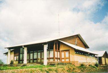
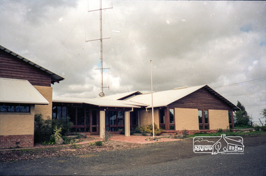
Photograph, Emergency Operations Centre, S.E.S., Kangaroo Ground
... Emergency Operations Centre, S.E.S., Kangaroo Ground......emergency centre...Centre (ICC) was located here. Described in "Worst of Days: Inside the black Saturday firestorm" by Karen Kissane (access via Google books): "..the ICC is part of a mud brick complex built in the 1980s as an emergency operations centre for several agencies, including the State Emergency Service. ...Two colour photographs of mud brick Emergency Operations Centre building, Kangaroo Ground...The 1988 emergency operations centre and the surrounding site to the title boundaries. ...In 2017 known as the Kangaroo Ground Operations Centre a facility for hire managed by the Shire of Nillumbik. On 7 February 2009 (Black Saturday) the CFA Incident Control Centre (ICC) was located here. Described in "Worst of Days: Inside the black Saturday firestorm" by Karen Kissane (access via Google books): "..the ICC is part of a mud brick complex built in the 1980s as an emergency operations centre for several agencies, including the State Emergency Service. It is also home to the headquarters of the CFA's Lower Yarra Group. A small office with a whiteboard would be the incident controller's office throughout the office, but a larger central room, with data projectors, "smart boards" and maps would house the rest of the team.."Statement of Significance From the Victorian Heritage Database (2010) What is significant? The 1988 emergency operations centre and the surrounding site to the title boundaries. How is it significant? The emergency operations centre is architecturally, aesthetically, socially and historically significant to the Shire of Nillumbik. Why is it significant? The emergency operations centre is architecturally and historically significant as a good and rare example of a large public building constructed in a 1980s version of the 'Eltham style', and as a rare attempt to adapt the 'Eltham-style' aesthetic to meet the changing demands of the Shire in the 1980s (Criteria B, D & E). The emergency operations centre is architecturally and aesthetically significant because it is constructed of mud brick and features: a central entry with a tile mural (Criterion E). The emergency operations centre is socially significant because it is a focal point for the community and has played an important role in protecting the community since 1988 (Criterion G).Two colour photographs of mud brick Emergency Operations Centre building, Kangaroo Groundbuildings, mud brick, emergency centre, kangaroo ground -
 Eltham District Historical Society Inc
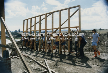
Photograph - Colour Print, SES members assisting with construction work on the Eltham Emergency Operations Centre and Kangaroo Ground Hall, 35 Kangaroo Ground-St Andrews Road, Kangaroo Ground, 1988
... SES members assisting with construction work on the Eltham Emergency Operations Centre and Kangaroo Ground Hall, 35 Kangaroo Ground-St Andrews Road, Kangaroo Ground......Eltham Emergency Operations Centre...Located at 35 Kangaroo Ground-St Andrews Road, Kangaroo Ground The centre was jointly funded by the Shire of Eltham, Community Employment Programme, Country Fire Authority and State Emergency Service. ...Construction kangaroo ground hall mudbrick construction State Emergency Service (Eltham) Eltham Emergency Operations Centre 3 Colour print 10 x 15 cm Originally housed in a 34.5 x 36 x 2.5 cm expandable album with padded cream covers and gold accents; 18 page inserts with clear pocket inserts holding 6 photos per side, total capacity 216 10 x 15 cm photo prints; showing yellowing with age SES members assisting with construction work on the Eltham Emergency Operations Centre and Kangaroo Ground Hall, 35 Kangaroo Ground-St Andrews Road, Kangaroo Ground Photograph Colour Print ...Located at 35 Kangaroo Ground-St Andrews Road, Kangaroo Ground The centre was jointly funded by the Shire of Eltham, Community Employment Programme, Country Fire Authority and State Emergency Service. It was opened by the Shire President of the Shire of Eltham, Cr. Alan Baker, at a ceremony attended by Members of Parliament, Councillors, & Representatives of the Victoria Police, Country Fire Authority, State Emergency Service, Ambulance Service Melbourne, Salvation Army & residents of the Shire of Eltham on Saturday, 13 February 1988.construction, kangaroo ground hall, mudbrick construction, state emergency service (eltham), eltham emergency operations centre -
 Eltham District Historical Society Inc
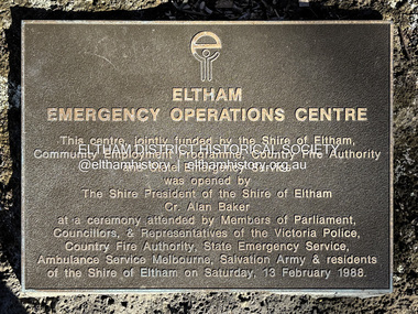
Photograph - Digital Photograph, Peter Pidgeon, Plaque, Eltham Emergency Operations Centre (and Kangaroo Ground Hall), 35 Kangaroo Ground-St Andrews Road, Kangaroo Ground, 5 July 2025
... Plaque, Eltham Emergency Operations Centre (and Kangaroo Ground Hall), 35 Kangaroo Ground-St Andrews Road, Kangaroo Ground......Eltham Emergency Operations Centre...The dedication plaque, mounted on a rock near the flag pole at entrance reads: This centre, jointly funded by the Shire of Eltham, Community Employment Programme, Country Fire Authority and State Emergency Service was opened by The Shire President of the Shire of Eltham Cr. ...Alan Baker Eltham Emergency Operations Centre Salvation Army shire of eltham State Emergency Service (Eltham) Victoria Police Peter & Elizabeth Pidgeon Collection Born digital image file Plaque, Eltham Emergency Operations Centre (and Kangaroo Ground Hall), 35 Kangaroo Ground-St Andrews Road, Kangaroo Ground Photograph Digital Photograph Peter Pidgeon ...The dedication plaque, mounted on a rock near the flag pole at entrance reads: This centre, jointly funded by the Shire of Eltham, Community Employment Programme, Country Fire Authority and State Emergency Service was opened by The Shire President of the Shire of Eltham Cr. Alan Baker at a ceremony attended by Members of Parliament, Councillors, & Representatives of the Victoria Police, Country Fire Authority, State Emergency Servicve, Ambulance Service Melbourne, Salvation Army & residents of the Shire of Eltham on Saturday, 13 February 1988. See also: Kangaroo Ground Hall. (2025, July 5). Retrieved from https://www.nillumbik.vic.gov.au/Council/Facilities-and-property/Council-facilities-for-hire/Kangaroo-Ground-Hallkangaroo ground hall, mudbrick construction, nillumbik shire council property, ambulance service victoria, community employment program, country fire authority, cr. alan baker, eltham emergency operations centre, salvation army, shire of eltham, state emergency service (eltham), victoria police, peter & elizabeth pidgeon collection -
 Eltham District Historical Society Inc
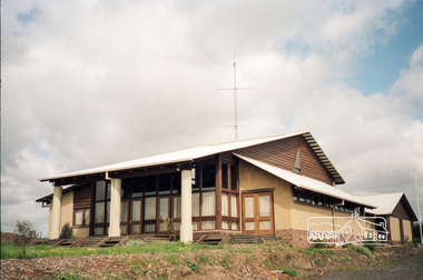
Photograph, Kangaroo Ground Emergency Operations Centre, 35 Kangaroo Ground-St Andrews Road, Kangaroo Ground
... Kangaroo Ground Emergency Operations Centre, 35 Kangaroo Ground-St Andrews Road, Kangaroo Ground...kangaroo ground emergency operations centre...Eltham District Historical Society Inc 728 Main Rd Eltham melbourne shire of eltham kangaroo ground-st andrews road kangaroo ground emergency operations centre kangaroo ground Kodak GA 100 5095 Roll of 35mm colour negative film, 5 of 7 strips Kangaroo Ground Emergency Operations Centre, 35 Kangaroo Ground-St Andrews Road, Kangaroo Ground Photograph ...Roll of 35mm colour negative film, 5 of 7 stripsKodak GA 100 5095shire of eltham, kangaroo ground-st andrews road, kangaroo ground emergency operations centre, kangaroo ground -
 Eltham District Historical Society Inc
Photograph, Kangaroo Ground Emergency Operations Centre, 35 Kangaroo Ground-St Andrews Road, Kangaroo Ground
... Kangaroo Ground Emergency Operations Centre, 35 Kangaroo Ground-St Andrews Road, Kangaroo Ground...kangaroo ground emergency operations centre...Eltham District Historical Society Inc 728 Main Rd Eltham melbourne shire of eltham kangaroo ground-st andrews road kangaroo ground emergency operations centre kangaroo ground Kodak GA 100 5095 Roll of 35mm colour negative film, 5 of 7 strips Kangaroo Ground Emergency Operations Centre, 35 Kangaroo Ground-St Andrews Road, Kangaroo Ground Photograph ...Roll of 35mm colour negative film, 5 of 7 stripsKodak GA 100 5095shire of eltham, kangaroo ground-st andrews road, kangaroo ground emergency operations centre, kangaroo ground -
 Whitehorse Historical Society Inc.
Photograph, Whitehorse Emergency Relief Network
... eastern emergency relief centre...The object was to collect domestic items of good quality to assist people in need, especially women who have been the victims of domestic violence. eastern emergency relief centre thornton crescent mitcham nos 10-12 Coloured photograph of the interior of the Whitehorse Emergency Relief Network 10-12, Thornton Crescent, Nunawading. ...The Nunawading Ladies Benevolent Society became the Whitehorse Emergency Relief Network in 1999, when a number of local organizations were encouraged to form a network by Betty and Keith Rooney. The object was to collect domestic items of good quality to assist people in need, especially women who have been the victims of domestic violence.Coloured photograph of the interior of the Whitehorse Emergency Relief Network 10-12, Thornton Crescent, Nunawading. Domestic goods showneastern emergency relief centre, thornton crescent mitcham nos 10-12 -
 Eltham District Historical Society Inc
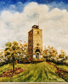
Photograph, Oil painting by Dacre Smyth of the Kangaroo Ground War Memorial Tower
... War Memorials of Victoria, RSL Collection; held at Kangaroo Ground State Emergency Centre (Contained in an album originally put together by Harry Gilham. ...Eltham District Historical Society Inc 728 Main Rd Eltham melbourne War Memorials of Victoria, RSL Collection; held at Kangaroo Ground State Emergency Centre (Contained in an album originally put together by Harry Gilham. ...War Memorials of Victoria, RSL Collection; held at Kangaroo Ground State Emergency Centre (Contained in an album originally put together by Harry Gilham. Photos subsequently relocated to photosafe archival storage.) [2001]Colour photographdacre smyth, kangaroo ground, war memorial tower -
 Melbourne Tram Museum
Document - Instruction, Metropolitan Transit Authority (MTA), "Metropolitan Transit Authority / Tram & Bus Division / Fleet Operations Centre", mid 1980's
... Two page printed instruction titled "Metropolitan Transit Authority / Tram & Bus Division / Fleet Operations Centre", detailing how drivers could operate the system, testing, messages, how to contact the centre, emergency messages, explanations, passenger counts, run cards....Melbourne Tram Museum 8 Wallen Road Hawthorn melbourne Trams tramways AVM Automatic Vehicle Monitoring MTA Fleet Operations Centre Two page printed instruction titled "Metropolitan Transit Authority / Tram & Bus Division / Fleet Operations Centre", detailing how drivers could operate the system, testing, messages, how to contact the centre, emergency messages, explanations, passenger counts, run cards. ...Two page printed instruction titled "Metropolitan Transit Authority / Tram & Bus Division / Fleet Operations Centre", detailing how drivers could operate the system, testing, messages, how to contact the centre, emergency messages, explanations, passenger counts, run cards.trams, tramways, avm, automatic vehicle monitoring, mta, fleet operations centre -
 Eltham District Historical Society Inc
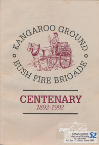
Book, Bruce Bence, Kangaroo Ground Bush Fire Brigade, centenary 1892-1992 : the story of the Kangaroo Ground Fire Brigade / Bruce Bence, 1992
... Contents (described as Index): The early days, Ewen Hugh Cameron, 1914-1939, Supporting organisations, Eltham Emergency Operations Centre, Kangaroo Ground Fire Brigade Ladies Auxiliary, The fire tower, the Salvation Army and Red Cross, 1930-1992, The Kangaroo Ground Fire Brigade Today, Kangaroo Ground Fire Brigade Chronology. ...Eltham District Historical Society Inc 728 Main Rd Eltham melbourne Contents (described as Index): The early days, Ewen Hugh Cameron, 1914-1939, Supporting organisations, Eltham Emergency Operations Centre, Kangaroo Ground Fire Brigade Ladies Auxiliary, The fire tower, the Salvation Army and Red Cross, 1930-1992, The Kangaroo Ground Fire Brigade Today, Kangaroo Ground Fire Brigade Chronology. ...Contents (described as Index): The early days, Ewen Hugh Cameron, 1914-1939, Supporting organisations, Eltham Emergency Operations Centre, Kangaroo Ground Fire Brigade Ladies Auxiliary, The fire tower, the Salvation Army and Red Cross, 1930-1992, The Kangaroo Ground Fire Brigade Today, Kangaroo Ground Fire Brigade Chronology. Includes a list of names of office bearers. Also includes references to neighbouring brigades and copies of historical newspaper articles. This publication was supported by the resources, information and facilities of The Shire of Eltham Historical Society.This book is significant in that not only does it traces the development of Kangaroo Ground Bush fire brigade since 1892 and of emergency services in the area but it also gives an insight into the people and their community.Softcover; 61 p., [7] p. of plates : b&w ill., 7 maps, ports.ISBN 064606651Xkangaroo ground, fire brigades, emeregency services, kangaroo ground fire brigade, fires, bush fires, shire of eltham war memorial, kangaroo ground tower -
 National Wool Museum
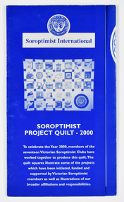
Archive - Soroptimist Project Quilt 2000 Brochure, Soroptimist International, 2000
... Donation of toiletries to women's shelters, police lock ups and church emergency centres in the western suburbs of Melbourne by SI Cut Paw Paw. ...Donation of toiletries to women's shelters, police lock ups and church emergency centres in the western suburbs of Melbourne by SI Cut Paw Paw. ...Brochure to accompany the Soroptimist Quilt Project 2000. The quilt was made by members of seventeen Soroptimist International clubs across Victoria to celebrate the Year 2000. The quilt squares illustrate some of the projects initiated, funded and supported by Victorian Soroptimists as well as illustrations of broader affiliations and responsibilities, including to the UN. Examples include the S.I.A.M. (Soroptimist International Aids Mediation) project by SI Berwick in Northern Thai villages which established industries and health programs for women and girls as viable alternatives to the sex industry. Revegetation of woodlands, wetlands and cleared land by SI Deakin. Donation of toiletries to women's shelters, police lock ups and church emergency centres in the western suburbs of Melbourne by SI Cut Paw Paw. Founded in 1921, Soroptimist International is a global volunteer movement with a network of around 72,000 club members in 121 countries. Advocating for human rights and gender equality, at the heart of Soroptimist International’s advocacy is its work across seven UN Centres, where UN representatives ensure that the voices of women and girls are heard. Memberships work on grassroots projects that help women and girls achieve their individual and collective potential, realise aspirations and have an equal voice in communities worldwide. It has a flourishing Club in Geelong. The quilt has been displayed in Soroptimist Headquarters Victoria at 383 Toorak Road, South Yarra (Soroptimist House) since touring the State of Victoria in 2000. Soroptimist House has been sold with the funds raised to go to furthering the objects of Soroptimism.A3 sized folded brochure printed in blue and white depicting images and text relating to squares of the Soroptimist Project Quilt 2000.front: [printed] SOROPTIMIST / INTERNATIONAL / Soroptimist International / SOROPTIMIST / PROJECT QUILT - 2000 / To celebrate the Year 2000, members of the / seventeen Victorian Soroptimist Clubs have / worked together to produce this quilt. The / quilt squares illustrate some of the projects / which have been initiated, funded and / supported by Victorian Soroptimist / members as well as illustrations of our / broader affiliations and responsibilities.quilt, women, soroptimist, victoria, community, clubs, human rights, gender equality, united nations -
 National Wool Museum
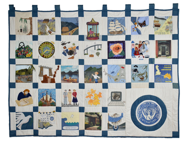
Textile - Soroptimist Project Quilt, Soroptimist International, 2000
... Donation of toiletries to women's shelters, police lock ups and church emergency centres in the western suburbs of Melbourne by SI Cut Paw Paw. ...Donation of toiletries to women's shelters, police lock ups and church emergency centres in the western suburbs of Melbourne by SI Cut Paw Paw. ...The quilt was made by members of seventeen Soroptimist International clubs across Victoria to celebrate the Year 2000. The quilt squares illustrate some of the projects initiated, funded and supported by Victorian Soroptimists as well as illustrations of broader affiliations and responsibilities, including to the UN. Examples include the S.I.A.M. (Soroptimist International Aids Mediation) project by SI Berwick in Northern Thai villages which established industries and health programs for women and girls as viable alternatives to the sex industry. Revegetation of woodlands, wetlands and cleared land by SI Deakin. Donation of toiletries to women's shelters, police lock ups and church emergency centres in the western suburbs of Melbourne by SI Cut Paw Paw. Founded in 1921, Soroptimist International is a global volunteer movement with a network of around 72,000 club members in 121 countries. Advocating for human rights and gender equality, at the heart of Soroptimist International’s advocacy is its work across seven UN Centres, where UN representatives ensure that the voices of women and girls are heard. Memberships work on grassroots projects that help women and girls achieve their individual and collective potential, realise aspirations and have an equal voice in communities worldwide. It has a flourishing Club in Geelong. The quilt was displayed from 2001 until 2023 in Soroptimist Headquarters Victoria at 383 Toorak Road, South Yarra (Soroptimist House) since touring the State of Victoria in 2000. Soroptimist House has been sold with the funds raised to go to furthering the objectives of Soroptimism.Cream patchwork quilt with 31 squares depicting various scenes and motifs. The Soroptimist logo features in the bottom right corner.quilt, women, soroptimist, victoria, community, clubs, human rights, gender equality, united nations -
 Eltham District Historical Society Inc
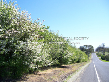
Photograph - Digital Photograph, Marguerite Marshall, Hawthorn hedges, Eltham-Yarra Glen Road, Kangaroo Ground, 3 October 2006
... As late as the 1960s, corners were cut to form sweeping curves above and alongside the Kangaroo Ground Cemetery and opposite the Emergency Operations Centre. In the latter case, the farmers – understanding their hedgerows as important heritage – insisted upon their reinstatement to conform to the altered road alignment. ...As late as the 1960s, corners were cut to form sweeping curves above and alongside the Kangaroo Ground Cemetery and opposite the Emergency Operations Centre. In the latter case, the farmers – understanding their hedgerows as important heritage – insisted upon their reinstatement to conform to the altered road alignment. ...Hawthorn hedges are important reminders of Kangaroo Ground's Scottish heritage. They are Registered on the Victorian Heritage Register. They are "historically significant because the planting of hawthorn hedges reflects the adoption of Eurorpean farming techniques by the Kangaroo Ground population in the period following settlement and because the grid pattern of paddocks that the Hawthorn hedges define is very different to today's farm landscapes." Covered under Heritage Overlay, Nillumbik Planning Scheme. Published: Nillumbik Now and Then / Marguerite Marshall 2008; photographs Alan King with Marguerite Marshall.; p21 Hawthorn hedges bordering Kangaroo Ground’s gently rolling farmlands are important reminders of its Scottish heritage and are rare so close to Melbourne.1 As early as the 1840s newly arrived farmers from Scotland planted hawthorn hedges around their properties, to protect crops from the numerous kangaroos and wallabies. Many of these hedges survive today. These farmers had the good fortune to settle some of the most fertile land available for cropping in the Colony of Victoria. At that time the black volcanic soil could sustain an amazing two crops a year. By the mid 1850s, 500 acres (202ha) of wheat were growing in Kangaroo Ground. But the crops were threatened by kangaroos, which were so plentiful, that Surveyor-General, Robert Hoddle, named the district Kangaroo Ground in 1838. As post-and-rail fences proved inadequate barriers for the bounding kangaroos, the Scots planted hawthorn hedgerows as they had done in Scotland. Some also used the hedges to net birds, presumably for the table. Interestingly the farmers in the bordering townships of Panton Hill and Christmas Hills, did not plant hawthorn hedges around their properties. Perhaps it was because by the time they settled in the 1860s and 1870s most of the wildlife had been gunned down by residents.2 The canny Scots planted the hedges on public land outside their own farms, as the hedgerows could spread to about five yards (five m) in width. With this impenetrable barrier Kangaroo Ground’s industrious farmers flourished to gain the economic power that saw the Shire of Eltham governed from Kangaroo Ground for 79 years (1858-1937). The Scots jealously guarded their land, so hard to get in Scotland. That is why they refused to release any of it ‘for local roads to follow easier grades as was the case in surrounding districts where roads generally followed ridgelines or streams’.3 Instead the roads were built in accordance with the magnetic bearings of their first survey in 1847 whether that suited the steep topography or not. This could force traffic to diverge when wet through Greensborough and Diamond Creek. Until 1921, the Eltham-Yarra Glen Road beside Wellers Restaurant, ‘dipped down into the upper reaches of Stony Creek’.4 Later some corners were compulsorily cut for the increasing motor traffic. As late as the 1960s, corners were cut to form sweeping curves above and alongside the Kangaroo Ground Cemetery and opposite the Emergency Operations Centre. In the latter case, the farmers – understanding their hedgerows as important heritage – insisted upon their reinstatement to conform to the altered road alignment. Kangaroo Ground’s ancient manna gums also point to the district’s history and to that of the hedgerows. The Aboriginal people had transformed the original forests into grasslands with the fires they lit to attract kangaroos, (which the Scots were to exclude by planting hedgerows). But the Wurundjeri hunters left the gums (Eucalyptus vimminalis cygnetensis), on the grasslands as ‘stalking trees’ to hunt kangaroos. The hawthorn hedges in Kangaroo Ground were neglected for around 60 years from about the middle of the 20th century. Bushfires had created gaps and the hedgerows were not trimmed. Then in late 2005, local historian Mick Woiwod, formed a group to lobby the Nillumbik Shire to restore the hedges, which could last for many centuries. Some hedges in parts of Britain date back to AD 800.5 Although the original Scottish farmers have gone, the hedges are a reminder of when they flourished in the district, which has changed little in 150 years.This collection of almost 130 photos about places and people within the Shire of Nillumbik, an urban and rural municipality in Melbourne's north, contributes to an understanding of the history of the Shire. Published in 2008 immediately prior to the Black Saturday bushfires of February 7, 2009, it documents sites that were impacted, and in some cases destroyed by the fires. It includes photographs taken especially for the publication, creating a unique time capsule representing the Shire in the early 21st century. It remains the most recent comprehenesive publication devoted to the Shire's history connecting local residents to the past. nillumbik now and then (marshall-king) collection, eltham-yarra glen road, hawthorn hedgerow, kangaroo ground -
 Stawell Historical Society Inc
Archive, Plans from the Dept. Works Ararat
... Archive 4262 Plans For Pleasent Creek 4262 - Existing Plans for Pleasent Creek 4262A - 2A Bellfield Unit 4262B - 2B Fyans Unit 4262C - 2C Nurses Unit 4262D - Biala Unit 4262E - Hostel Unit 4262F - Residence 3 & 4 (X2) 4262G - Residence 5 & 6 4262H - Nara Unit 4262I - Syme Unit 4262J - Lonsdale Unit 4262K - School Buildings 4262L - Recreation Building 4262M - Administration Building 4262N - Alexandra Building 42620 - L.T.O. building 4262P - Engineers Workshop & Laundry 4262Q - Sewing Room & Stores 4262R - Carpenters, Painters & Gardener's Workshops 4262S - 3 Existing Plans for Pleasent Creek Centre Stawell & Emergency Water Legend 4262T - 7 Existing Plans for Plesent Creek Stawell Centre Stawell Inc: Grid Squares 4262-1 73.5 X 56 CM Sheet No.1 New Dining Room Special School Amended Setout of Windows 4262-1A - 73.5 X 56 CM Sheet No. 2 Special School Stawell Joiners details 4262-1B - 73.5 X 56 CM Sheet No. 3 Pleasant Creek School: New Dining Room 4262-1C -73.5 X 56 CM Sheet No. 4 Pleasant Creek School Joinery details 4262-1D - 73.5 X 56 CM Sheet No. 5 Pleasant Creek School Joinery Details 4262-1E - 48 X 39 CM Section AA Pleasant Creek School Dining Room Stainless Steel Sinks & Drains 4262 -1F 50 X 69X5 CM School for Subnormal Children - Stawell Mental Hospital Elvation and Accordion 4262-1G 56 X 40 CM Sheet 6 Stawell Pleasant Creek School - Joinery Detail 4262-1H 75 X 54 CM Stawell Pleasant Creek School - Detail of Serving Window 4262 -1I 75 X 54 CM Stawell Hospital for the Insane - Cills to Windows, Store and soon to be Male Division 4262 -1J 50.5 X 24 CM Stawell Pleasant Creek School - deatils of Serving Window 4262 -2 39 X 34 CM Concongella School 1136 Sundry Works etc. 4262-2A 20 X 35 CM State School 1702 Joel Joel - Remodeling & Repairs Painting etc. 4262-2B 36 X 44.5 CM Mokepilly School Remodelling 4262-2C 21 X 34 CM 2951 Marnoo East - Sketch of Proposed Cloak Room 4262-2D 21 X 34 CM SS 2951 Marnoo East Elevation Showing New Cloak Room 4262-2E 40 X 39 CM Additions & Alterations to Concongella School 1136 4262-2F 21.3 X 33.5 CM School 2951 Marnoo East Elvation and Ground Plan 4262-2G 38 X 33.5 CM School 1554 Marnoo & Residence 4262-2H 21.5 33.5 CM Marnoo SS No 1554 Repairs and Painting 4262-2I 205 X 32 CM Marnoo School 1554 Alternative Drawingsfor building In Brick 4262-2J 50 X 43.5 CM New Concrete School 1554 Marnoo 4262-2K 62 X 56 CM Removal & Alterations to Marnoo's School No. 1554 4262-2L 49.5 X 33.5 CM Great Western School 860 - Teacher's Residence 4262-2M 20.5 X 33.5 CM Great western School 860 - Elevation & Ground Plan 4262-2N 20.5 X 33.5 CM Great Western School 860 - Shelter Sheds & Tank Stand 4262-2O 25.5 X 30 CM Great Western School 860 - Floor Plan 4262-2P 20 X 34 CM Residence to Great Western Schhool - Plastering & Painting etc,. 4262-2Q 59 X 50.5 CM Great Western School860 - Additions 4262-2R 21 X 33 CM Plan school 263 Glenorchy 4262-2S 21 X 33 CM Plan School 263 Glenorchy 4262-2T 35 X 38 CM Glenorchy School 263 Remodelling etc,. to Teacher's Residence 4262-2U 33.5 X 22 CM Repairs & Repainting School & Residence Glenorchy SS 263 4262-2V 53 X 34 CM Proposed Sleepout for Teachers Residence Glenorchy School 4262-2W 53.5 38 CM Glenorchy School No. 263 and Residence Raising School buildings etc,. 4262-2X 29 x 56 CM Glenorchy School 263 New Cloak Room etc. 4262-3 22 X 31 CM Drawing of Part of Builing 4262-3A 35 X 46 CM Stawell Roof Plan & Side Elevation 4262-3B 48 X 65 CM State School Drawing No 1 4262-3C 32 X 27 CM Renewal of Existing water Supply 4262-3E 61 X 40 CM Stawell Infant State School 503 - External Repairs & Renovations 4262-3F 48.5 X 53 CM Education Department Stawell State School Drawig No 2 Contract 181 4262-3G 73 X 55 CM Alterations & Additions S.S. 502 Stawell Drawing No.1 4262-3H 73 X 55 CM Alterations & Additions S.S. 502 Stawell Drawing No.2 4242-3I 73 X 55 CM Alterations & Additions S.S. 502 Stawell Drawing No.3 4262-3J 56 X 34 CM State School 502 Plan Clarifying & Chlorinating Chamber 4262-3K 33 X 21 CM Part Ground Plan StawellSchool 502 - Accordion Doors etc. 4262-3L 60 X 54 CM Accordion Door details for School at Stawell 502 4262-3M 69 X 52 CM Stawell State School No 502 External repairs - Renovations 4262-3N 72 X 55 CM Altereed & Additions State School 502 Drawing No 1 4262-30 35 X 21 CM Stawell School 502 New Wood Shed etc 4262-3P 68 X 34 CM Main School - New Gutters shown thus. ...Stawell Historical Society Inc 46 Longfield St Stawell grampians Archive 4262 Plans For Pleasent Creek 4262 - Existing Plans for Pleasent Creek 4262A - 2A Bellfield Unit 4262B - 2B Fyans Unit 4262C - 2C Nurses Unit 4262D - Biala Unit 4262E - Hostel Unit 4262F - Residence 3 & 4 (X2) 4262G - Residence 5 & 6 4262H - Nara Unit 4262I - Syme Unit 4262J - Lonsdale Unit 4262K - School Buildings 4262L - Recreation Building 4262M - Administration Building 4262N - Alexandra Building 42620 - L.T.O. building 4262P - Engineers Workshop & Laundry 4262Q - Sewing Room & Stores 4262R - Carpenters, Painters & Gardener's Workshops 4262S - 3 Existing Plans for Pleasent Creek Centre Stawell & Emergency Water Legend 4262T - 7 Existing Plans for Plesent Creek Stawell Centre Stawell Inc: Grid Squares 4262-1 73.5 X 56 CM Sheet No.1 New Dining Room Special School Amended Setout of Windows 4262-1A - 73.5 X 56 CM Sheet No. 2 Special School Stawell Joiners details 4262-1B - 73.5 X 56 CM Sheet No. 3 Pleasant Creek School: New Dining Room 4262-1C -73.5 X 56 CM Sheet No. 4 Pleasant Creek School Joinery details 4262-1D - 73.5 X 56 CM Sheet No. 5 Pleasant Creek School Joinery Details 4262-1E - 48 X 39 CM Section AA Pleasant Creek School Dining Room Stainless Steel Sinks & Drains 4262 -1F 50 X 69X5 CM School for Subnormal Children - Stawell Mental Hospital Elvation and Accordion 4262-1G 56 X 40 CM Sheet 6 Stawell Pleasant Creek School - Joinery Detail 4262-1H 75 X 54 CM Stawell Pleasant Creek School - Detail of Serving Window 4262 -1I 75 X 54 CM Stawell Hospital for the Insane - Cills to Windows, Store and soon to be Male Division 4262 -1J 50.5 X 24 CM Stawell Pleasant Creek School - deatils of Serving Window 4262 -2 39 X 34 CM Concongella School 1136 Sundry Works etc. 4262-2A 20 X 35 CM State School 1702 Joel Joel - Remodeling & Repairs Painting etc. 4262-2B 36 X 44.5 CM Mokepilly School Remodelling 4262-2C 21 X 34 CM 2951 Marnoo East - Sketch of Proposed Cloak Room 4262-2D 21 X 34 CM SS 2951 Marnoo East Elevation Showing New Cloak Room 4262-2E 40 X 39 CM Additions & Alterations to Concongella School 1136 4262-2F 21.3 X 33.5 CM School 2951 Marnoo East Elvation and Ground Plan 4262-2G 38 X 33.5 CM School 1554 Marnoo & Residence 4262-2H 21.5 33.5 CM Marnoo SS No 1554 Repairs and Painting 4262-2I 205 X 32 CM Marnoo School 1554 Alternative Drawingsfor building In Brick 4262-2J 50 X 43.5 CM New Concrete School 1554 Marnoo 4262-2K 62 X 56 CM Removal & Alterations to Marnoo's School No. 1554 4262-2L 49.5 X 33.5 CM Great Western School 860 - Teacher's Residence 4262-2M 20.5 X 33.5 CM Great western School 860 - Elevation & Ground Plan 4262-2N 20.5 X 33.5 CM Great Western School 860 - Shelter Sheds & Tank Stand 4262-2O 25.5 X 30 CM Great Western School 860 - Floor Plan 4262-2P 20 X 34 CM Residence to Great Western Schhool - Plastering & Painting etc,. 4262-2Q 59 X 50.5 CM Great Western School860 - Additions 4262-2R 21 X 33 CM Plan school 263 Glenorchy 4262-2S 21 X 33 CM Plan School 263 Glenorchy 4262-2T 35 X 38 CM Glenorchy School 263 Remodelling etc,. to Teacher's Residence 4262-2U 33.5 X 22 CM Repairs & Repainting School & Residence Glenorchy SS 263 4262-2V 53 X 34 CM Proposed Sleepout for Teachers Residence Glenorchy School 4262-2W 53.5 38 CM Glenorchy School No. 263 and Residence Raising School buildings etc,. 4262-2X 29 x 56 CM Glenorchy School 263 New Cloak Room etc. 4262-3 22 X 31 CM Drawing of Part of Builing 4262-3A 35 X 46 CM Stawell Roof Plan & Side Elevation 4262-3B 48 X 65 CM State School Drawing No 1 4262-3C 32 X 27 CM Renewal of Existing water Supply 4262-3E 61 X 40 CM Stawell Infant State School 503 - External Repairs & Renovations 4262-3F 48.5 X 53 CM Education Department Stawell State School Drawig No 2 Contract 181 4262-3G 73 X 55 CM Alterations & Additions S.S. 502 Stawell Drawing No.1 4262-3H 73 X 55 CM Alterations & Additions S.S. 502 Stawell Drawing No.2 4242-3I 73 X 55 CM Alterations & Additions S.S. 502 Stawell Drawing No.3 4262-3J 56 X 34 CM State School 502 Plan Clarifying & Chlorinating Chamber 4262-3K 33 X 21 CM Part Ground Plan StawellSchool 502 - Accordion Doors etc. 4262-3L 60 X 54 CM Accordion Door details for School at Stawell 502 4262-3M 69 X 52 CM Stawell State School No 502 External repairs - Renovations 4262-3N 72 X 55 CM Altereed & Additions State School 502 Drawing No 1 4262-30 35 X 21 CM Stawell School 502 New Wood Shed etc 4262-3P 68 X 34 CM Main School - New Gutters shown thus. ...Archive 4262 Plans For Pleasent Creek 4262 - Existing Plans for Pleasent Creek 4262A - 2A Bellfield Unit 4262B - 2B Fyans Unit 4262C - 2C Nurses Unit 4262D - Biala Unit 4262E - Hostel Unit 4262F - Residence 3 & 4 (X2) 4262G - Residence 5 & 6 4262H - Nara Unit 4262I - Syme Unit 4262J - Lonsdale Unit 4262K - School Buildings 4262L - Recreation Building 4262M - Administration Building 4262N - Alexandra Building 42620 - L.T.O. building 4262P - Engineers Workshop & Laundry 4262Q - Sewing Room & Stores 4262R - Carpenters, Painters & Gardener's Workshops 4262S - 3 Existing Plans for Pleasent Creek Centre Stawell & Emergency Water Legend 4262T - 7 Existing Plans for Plesent Creek Stawell Centre Stawell Inc: Grid Squares 4262-1 73.5 X 56 CM Sheet No.1 New Dining Room Special School Amended Setout of Windows 4262-1A - 73.5 X 56 CM Sheet No. 2 Special School Stawell Joiners details 4262-1B - 73.5 X 56 CM Sheet No. 3 Pleasant Creek School: New Dining Room 4262-1C -73.5 X 56 CM Sheet No. 4 Pleasant Creek School Joinery details 4262-1D - 73.5 X 56 CM Sheet No. 5 Pleasant Creek School Joinery Details 4262-1E - 48 X 39 CM Section AA Pleasant Creek School Dining Room Stainless Steel Sinks & Drains 4262 -1F 50 X 69X5 CM School for Subnormal Children - Stawell Mental Hospital Elvation and Accordion 4262-1G 56 X 40 CM Sheet 6 Stawell Pleasant Creek School - Joinery Detail 4262-1H 75 X 54 CM Stawell Pleasant Creek School - Detail of Serving Window 4262 -1I 75 X 54 CM Stawell Hospital for the Insane - Cills to Windows, Store and soon to be Male Division 4262 -1J 50.5 X 24 CM Stawell Pleasant Creek School - deatils of Serving Window 4262 -2 39 X 34 CM Concongella School 1136 Sundry Works etc. 4262-2A 20 X 35 CM State School 1702 Joel Joel - Remodeling & Repairs Painting etc. 4262-2B 36 X 44.5 CM Mokepilly School Remodelling 4262-2C 21 X 34 CM 2951 Marnoo East - Sketch of Proposed Cloak Room 4262-2D 21 X 34 CM SS 2951 Marnoo East Elevation Showing New Cloak Room 4262-2E 40 X 39 CM Additions & Alterations to Concongella School 1136 4262-2F 21.3 X 33.5 CM School 2951 Marnoo East Elvation and Ground Plan 4262-2G 38 X 33.5 CM School 1554 Marnoo & Residence 4262-2H 21.5 33.5 CM Marnoo SS No 1554 Repairs and Painting 4262-2I 205 X 32 CM Marnoo School 1554 Alternative Drawingsfor building In Brick 4262-2J 50 X 43.5 CM New Concrete School 1554 Marnoo 4262-2K 62 X 56 CM Removal & Alterations to Marnoo's School No. 1554 4262-2L 49.5 X 33.5 CM Great Western School 860 - Teacher's Residence 4262-2M 20.5 X 33.5 CM Great western School 860 - Elevation & Ground Plan 4262-2N 20.5 X 33.5 CM Great Western School 860 - Shelter Sheds & Tank Stand 4262-2O 25.5 X 30 CM Great Western School 860 - Floor Plan 4262-2P 20 X 34 CM Residence to Great Western Schhool - Plastering & Painting etc,. 4262-2Q 59 X 50.5 CM Great Western School860 - Additions 4262-2R 21 X 33 CM Plan school 263 Glenorchy 4262-2S 21 X 33 CM Plan School 263 Glenorchy 4262-2T 35 X 38 CM Glenorchy School 263 Remodelling etc,. to Teacher's Residence 4262-2U 33.5 X 22 CM Repairs & Repainting School & Residence Glenorchy SS 263 4262-2V 53 X 34 CM Proposed Sleepout for Teachers Residence Glenorchy School 4262-2W 53.5 38 CM Glenorchy School No. 263 and Residence Raising School buildings etc,. 4262-2X 29 x 56 CM Glenorchy School 263 New Cloak Room etc. 4262-3 22 X 31 CM Drawing of Part of Builing 4262-3A 35 X 46 CM Stawell Roof Plan & Side Elevation 4262-3B 48 X 65 CM State School Drawing No 1 4262-3C 32 X 27 CM Renewal of Existing water Supply 4262-3E 61 X 40 CM Stawell Infant State School 503 - External Repairs & Renovations 4262-3F 48.5 X 53 CM Education Department Stawell State School Drawig No 2 Contract 181 4262-3G 73 X 55 CM Alterations & Additions S.S. 502 Stawell Drawing No.1 4262-3H 73 X 55 CM Alterations & Additions S.S. 502 Stawell Drawing No.2 4242-3I 73 X 55 CM Alterations & Additions S.S. 502 Stawell Drawing No.3 4262-3J 56 X 34 CM State School 502 Plan Clarifying & Chlorinating Chamber 4262-3K 33 X 21 CM Part Ground Plan StawellSchool 502 - Accordion Doors etc. 4262-3L 60 X 54 CM Accordion Door details for School at Stawell 502 4262-3M 69 X 52 CM Stawell State School No 502 External repairs - Renovations 4262-3N 72 X 55 CM Altereed & Additions State School 502 Drawing No 1 4262-30 35 X 21 CM Stawell School 502 New Wood Shed etc 4262-3P 68 X 34 CM Main School - New Gutters shown thus. State School 502 Stawell Renewals Eaves Guttering 4262-3Q 58 X 34 CM State School No 502. Stawell Block Plan 4262-3R 73 X 55 CM State School 502 Drawing No.2 4262-4 99 X 79 CM State of Victoria Public Works Department - Layout of heating System Administration Block and Toddlers Playroom. Pleasant Creek special School (2 Copies) 42624A 86 X 89.5 CM Existing Layout of Peasnt Creek Centre Fire Service Water Mains 4262-4B 87X 59.5 CM Department of Human Services Victoria Emergancy Schematic Palns Pleasant Creek Centre ( Plans also in 4262 & 4262-1?) Cover Sheet. Former Pleasant Creek Hospital site. Sometimes referred to as Pleasant Creek Special School and sometimes Pleasant Creet Training Centre.Plans of Schools and other Buildings -
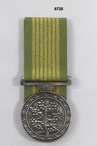 Bendigo Military Museum
Award - MEDAL
... Passchendaele Barracks Trust PBT720 National Emergency Medal Green and gold striped ribbon, top of medal Australian Coat of Arms and Wattle in centre of medal. ...The National Service Medal is awarded to persons who rendered sustained or significant service during Nationally significant emergencies in Australia.Green and gold striped ribbon, top of medal Australian Coat of Arms and Wattle in centre of medal.passchendaele barracks trust, pbt720, national emergency medal -
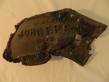 Kiewa Valley Historical Society
Roper's Hut Memorabilia
... Centre 31 Bogong High Plains Rd Mt Beauty high-country Roper's Hut was built in 1939 and was burnt down in 2003. It was rebuilt in 2008 and is situated on the Bogong High Plains on Duane Spur (where Duane's hut had been before it too was destroyed by (1939) bushfires, between Mt Nelse and Big River. The original hut was used as a shelter for cattlemen who grazed their cattle on the High Plains during summer. The Victorian High Country Huts Association Inc. members and friends helped rebuild the hut which is now used as an emergency ...Roper's Hut was built in 1939 and was burnt down in 2003. It was rebuilt in 2008 and is situated on the Bogong High Plains on Duane Spur (where Duane's hut had been before it too was destroyed by (1939) bushfires, between Mt Nelse and Big River. The original hut was used as a shelter for cattlemen who grazed their cattle on the High Plains during summer. The Victorian High Country Huts Association Inc. members and friends helped rebuild the hut which is now used as an emergency shelter for visitors to the High Plains.The memorabilia is significant as the items belonged to the Roper family who were one of the original settlers of the Kiewa Valley and one of the original families who drove their cattle up to the Bogong High Plains. The burnt plaque and forks and the rebuilding of the huts (Duane's & Roper's) are significant as bush fires are a constant threat to the Bogong High Plains destroying large areas at a time.1. Bronze Plaque and 2 damaged forks from Roper's Hut which was destroyed by bush fires in 2003. 2. DVD & USB and hard copy photos of the rebuild of Roper's Hut in January 2008.The plaque had 'In Memory of / John F. P. Roper/ died 3-12-1977 / Aged 78 years / He built the original hut Feb. 1939'roper's hut, cattlemen, bogong high plains, bronze plaque, roper family, bush fires -
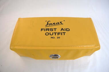 Kiewa Valley Historical Society
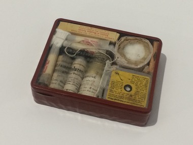
First Aid Kit, 1984
... Kiewa Valley Historical Society Mount Beauty Information Centre 31 Bogong High Plains Rd Mt Beauty high-country The State Electricity Commission of Victoria supplied First Aid Kits to its employees and 'ran' an ambulance during the construction of the Kiewa Hydro Electric Scheme (KHES). The KHES was constructed at the upper end of the Kiewa Valley in the Victorian mountains on the Bogong High Plains. This area is remote with difficult terrain requiring people working and enjoying recreational activities to carry a first aid kit in case of emergency ...The State Electricity Commission of Victoria supplied First Aid Kits to its employees and 'ran' an ambulance during the construction of the Kiewa Hydro Electric Scheme (KHES). The KHES was constructed at the upper end of the Kiewa Valley in the Victorian mountains on the Bogong High Plains. This area is remote with difficult terrain requiring people working and enjoying recreational activities to carry a first aid kit in case of emergency. This First Aid kit is light and portable enabling the user to 'fix' minor injuries and wait for access to medical assistance.This portable first aid kit was owned by a local Mt Beauty resident, Allan S. Clarke who was a long term staff employee for the State Electricity Commission of Victoria.First Aid Outfit (Kit), No.20 by "Sanax". Yellow plastic covered cardboard box with lid fastened by a metal swivel clasp. Complete with unused original contents displayed on two levels. On the top level - Absorbent lint in clear plastic bag; roll of Johnson's Cotton Wool in soft plastic; Plastic container of Sanax Aspirin tablets; glass bottle with brown plastic lid of Calamine Lotion; and steel scissors, safety pins and tweezers in small clear plastic bag. On the second/ bottom level - in a brown glass jar with brown plastic lid "Kuraburn for the treatment of Minor burns"; in a brown glass jar with brown plastic lid "Zeptic" (antiseptic); Johnson's Bandaids of varying shapes in a clear plastic bag; in a brown glass bottle with a brown plastic lid "Germistatic" (antiseptic); 2 packets of 4 Gauze bandages in clear plastic bags; and 1 large absorbent Gauze bandage in clear plastic bag.first aid kit; kiewa hydro electric scheme; sandax; medical aids; -
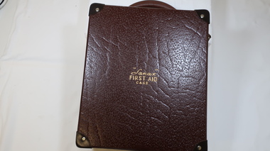 Kiewa Valley Historical Society
First Aid Case
... Kiewa Valley Historical Society Mount Beauty Information Centre 31 Bogong High Plains Rd Mt Beauty high-country Living, working, recreational activities in remote areas require precautions including a First Aid Kit. first aid kit first aid case sanax remote areas Outside on the lid: "Sanax" / First Aid / Case Brown rectangular case with a brown curved handle at one end and 2 clip fasteners at the front with a sliding lock fastener in the middle of them. All corners are reinforced. The inside has a lift out box, bandages, medication, tourniquet, snake/spider bite medication. There is a First Aid / Emergency ...Living, working, recreational activities in remote areas require precautions including a First Aid Kit.Brown rectangular case with a brown curved handle at one end and 2 clip fasteners at the front with a sliding lock fastener in the middle of them. All corners are reinforced. The inside has a lift out box, bandages, medication, tourniquet, snake/spider bite medication. There is a First Aid / Emergency / Instructions booklet inside the top of the case's lid.Outside on the lid: "Sanax" / First Aid / Casefirst aid kit, first aid case, sanax, remote areas -
 Kiewa Valley Historical Society
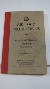
Book - Air Raid Precautions, WWII, Manual of General Training Sept. 1939
... Kiewa Valley Historical Society Mount Beauty Information Centre 31 Bogong High Plains Rd Mt Beauty high-country With the onset of WWII, the Victorian State Emergency Council of Defence printed this book for the volunteers who kept watch for enemy aeroplanes flying in the skies during the day and night. ...With the onset of WWII, the Victorian State Emergency Council of Defence printed this book for the volunteers who kept watch for enemy aeroplanes flying in the skies during the day and night. For success, training was necessary.During WWII the SECV township of Bogong had an Air Observer's Hut used to monitor the skies overhead for enemy planes. Men and women working on the Kiewa Hydro Electric Scheme volunteered to be rostered on duty. See also KVHS 0937 (photo) and KVHS 0938 (certificate)Small book grey with black print and a red binding with 64 pages. issued by the Victorian State Emergency Council for Civil Defence.Pages 26, 48 & 49 have pencil marks / notes.air raid, wwii, secv, kiewa hydro electric scheme, bogong, victorian state emergency council -
 Kiewa Valley Historical Society
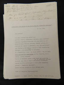
Papers - 'Operation Key Hold', June 1994
... Kiewa Valley Historical Society Mount Beauty Information Centre 31 Bogong High Plains Rd Mt Beauty high-country 'Operation Key Hold' was set up in June 1994 to establish a security network whereby (with written permission) members of the public could leave their house key at the Hospital in a safely, locked cupboard to be assessed by approved authority in case of emergency. ...'Operation Key Hold' was set up in June 1994 to establish a security network whereby (with written permission) members of the public could leave their house key at the Hospital in a safely, locked cupboard to be assessed by approved authority in case of emergency. This is similar to the emergency button (hung around the neck) which sounds an alarm at a central location and alerts appointed acquaintances for assistance - used currently (2015) Operation Key Hold was initiated in Mt Beauty for people at risk of being unable to call for assistance. The letters and notices are examples of setting up a community organisation which began in 1994 locally and became State wide later in the form of a distress alarm which worked by radio contact to a central location. Typed and hand written papers including letters and notices of varying sizes referring to the setting up of 'security network' whereby a house key is left (with written permission) at the Hospital in a safely locked cupboard. This would enable appropriate authorities to render assistance if required.operation-key-hold. community assistance. jan burnett.mt beauty. -
 Kiewa Valley Historical Society
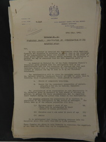
Evacuation Plans for children during WWII, 1941
... Kiewa Valley Historical Society Mount Beauty Information Centre 31 Bogong High Plains Rd Mt Beauty high-country During World War 2 the State Emergency Council for Civil Defence (Victoria) sent out forms to Municipal Councils requesting a survey to be carried out regarding the suitability of householders to accommodate persons, especially children, in the more dangerous parts of Victoria. ...During World War 2 the State Emergency Council for Civil Defence (Victoria) sent out forms to Municipal Councils requesting a survey to be carried out regarding the suitability of householders to accommodate persons, especially children, in the more dangerous parts of Victoria. Also, surveying parents as to their wishes regarding the evacuation of their own children if necessary. The documents list householders living in the Kiewa Valley including Gundowring giving an insight into the families (size, age, religion, sex), the homes (size, number and type of rooms), Water supply, Conveyance (motor or horse drawn), distance from railway station and school. Papers created by the State Emergency Council for Civil Defence, Premier's Department 1941 requesting Municipal Councils to survey people in case of the billeting of persons who may be evacuated from the more dangerous parts of Victoria. The Accommodation Survey lists the householder, details of the house, how many people living there and how many could be accommodated.There are also forms asking householders if they wish their children to be evacuated if necessary.Forms filled out in ink. world war ii; evacuation plans; kiewa valley; gundowring -
 Kiewa Valley Historical Society
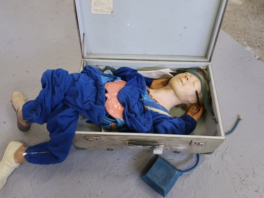
Resusci-Anne and Equipment
... Kiewa Valley Historical Society Mount Beauty Information Centre 31 Bogong High Plains Rd Mt Beauty high-country Resusci Anne was used for teaching both emergency workers and members of the general public. ...Resusci Anne was used for teaching both emergency workers and members of the general public. Developed by Asmund S. Laerdal, Peter Safar, and James Elam and produced by the company Laerdal Medical.The first version of rescue Annie was presented by Laerdal in 1960. Later the design was refined and included a simulated carotid pulse, eye pupils that could dilate and constrict and a system for recording the trainee's resuscitation performance on a paper tape. Ref. WikipediaUsed in the Kiewa Valley by Educators of First Aid and emergency workersSee KVHS 0542 for Resusci-Anne Repair Kit Doll type model with face, arms and legs folded into a 1950s carrying case. The model has blue clothing. Enclosed are the instructions for packing the model and papers for treatment of an unconscious patient.resusci anne, first aid, emergency education -
 Kiewa Valley Historical Society
Lamp Table Kerosene, pre 1950s
... Centre 31 Bogong High Plains Rd Mt Beauty high-country This particular lamp was made for the dinner table or "parlour". This was the most effective indoor lighting before electrical lighting was introduced in the 1940's. These table lights would have still been used after this time as emergency ...This particular lamp was made for the dinner table or "parlour". This was the most effective indoor lighting before electrical lighting was introduced in the 1940's. These table lights would have still been used after this time as emergency lighting during electrical power shortages (outages). These emergency lighting lamps, including candles, were eventually replaced by battery power. The Kiewa Valley was supplied by electricity well before many other rural regions due to the State Electricity Commission constructing the Kiewa Hydro Electricity power turbines (late 1930's to mid 1950's). Petrol and diesel generators were used in other rural regions before state wide electricity was available.The significance of this kerosene lamp to the Kiewa Valley is that it provides the proof that before the Hydro electricity scheme was established in the valley, householder and commerce relied on candle/kerosene power. Although at certain times before battery and solar energy became the night time lighters the sole source of lighting was candle power and kerosene power. The supply of both however was still required by most of the population by supply from city and larger country town suppliers. This nearly fully glass made table lamp(kerosene) has a large glass bowl/basin like kerosene storage unit with a glass circular finger handle (similar to a ordinary cup). Formed single star like patterns (50mm apart) encircle the centre of the bowl. On top of the bowl sits the metal (brass) wick holder with a small wheel protruding out one side for adjusting the wick length(increasing or decreasing the strength(regulating) of the amount of light projected. Four prongs rise from the circular base light fixture holding the windproof and refractive glass "pot belly" shield. lamp table, kerosene lamp, household lighting (non electrical) -
 Nhill Aviation Heritage Centre
Emergency Signaling Mirror, General Electric Company, 1940s
... Front is mirror, back is black with 50mm round mirror with sighting cross in centre Emergency Signaling Mirror General Electric Company ...These mirrors were carried by fighter pilots to signal to rescue crews if they were downed, particularly behind enemy lines.This mirror was carried by Max Carland part of his kit while flying missions from MorataiRectangular mirror with instructions on reverse side. Front is mirror, back is black with 50mm round mirror with sighting cross in centreEmergency signaling mirror (ESM/1) Sec.No. 4063 General Electric Company -
 Nhill Aviation Heritage Centre
Memorabilia - Emergency survival kit
... Nhill Aviation Heritage Centre 1 Aerodrome Road Nhill grampians This emergency kit was carried by Merv Schneider when flying missions out of Northern Australia. emergency kit survival kit merv schneider medical Emergency Sustenance Type E-3 Specifications Number 94-40441 Air Forces, U.S. ...This emergency kit was carried by Merv Schneider when flying missions out of Northern Australia.Red colour case with transparent lid packed tightly with various medical supplies, powders, ointments, drugs, dressings, razor blades and small signaling mirror. Emergency Sustenance Type E-3 Specifications Number 94-40441 Air Forces, U.S. Army.emergency kit, survival kit, merv schneider, medical -
 Bendigo Military Museum
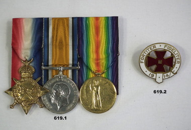
Award - MEDAL SET WW1 & BADGE, 1914 - post 1919
... The badge was an “Empress Club 1914 Emergency Voluntary Aid Committee badge”which was a Ladies Club in Dover street Piccadilly. “Fortiter Fideliter” meaning “Strongly Faithful”. The centre...The badge was an “Empress Club 1914 Emergency Voluntary Aid Committee badge”which was a Ladies Club in Dover street Piccadilly. “Fortiter Fideliter” meaning “Strongly Faithful”. The centre ...Leah Rosenthal ARRC (Born Melbourne) Enlisted in 1915 and embarked 18.12.15 from Australia to join the QAIMNSP service. Her service was terminted on 9.5.19. She was awarded the ARRC (2nd class) for her work at a CCS on the Western Front. Articles written about her state that she was also awarded an "MM". ARRC, (Royal Red Cross). CCS, (Casualty Clearing Station). MM, (Military Medal) QAIMNSP, (Queen Alexandria's Imperial Military Nursing Service) A brother Samuel was KIA in the war, refer 620. The badge was an “Empress Club 1914 Emergency Voluntary Aid Committee badge”which was a Ladies Club in Dover street Piccadilly. “Fortiter Fideliter” meaning “Strongly Faithful”. The centre of the badge is a Maltese Cross. There is a ribbon with the badge but missing. During WW1 the Club was used as a War Supply Depot. In 1917 a Red Cross hut was opened on the roof of the building. Pre war Leah had done her training at Alfred Hospital. After the war Leah and close friend Isabella Jobson bought St Lukes Private Hospital and renamed it “Vimy House”. Leah passed away in 1930. Isabella inaugurated and annual prize in Leah’s name at the Alfred Hospital for the best Theatre Nurse. Isabella had gone with Leah to England and they both served together during WW1..1) Medals, court mounted set of (3) re L.Rosenthal. 1, 1914-1915 Star. 2. War Medal 1914 -1918. 3. Victory Medal 1914 - 19 replica not engraved. .2) Badge metal slightly oval Red cross centre with white and gold trimming. In gold lettering "Fortiter Fideliter 1914" around the outside.,1) Sister L Rosenthal Q.A.I.M.N.S.Pmedals, hospitals, military, nursing -
Marysville & District Historical Society
THE TRIANGLE NEWS-VOL 5 NO 2-FEBRUARY 15 1980
... emergency service...letter to editor...1st marysville scouts & cubs...think it over...pot belly stove...swimming pool carnival...marysville lions club rodeo...film society...football...thinking day marysville guides & brownies...for sale...wanted to buy...community care centre...Marysville & District Historical Society 39 Darwin Street Marysville yarra-valley-and-the-dandenong-ranges marysville victoria australia state emergency service letter to editor 1st marysville scouts & cubs think it over pot belly stove swimming pool carnival marysville lions club rodeo film society football thinking day marysville guides & brownies for sale wanted to buy community care centre 21st birthday bingo cricket toilet marysville water works trust water restrictions THE TRIANGLE NEWS-VOL 5 NO 2-FEBRUARY 15 1980 ...marysville, victoria, australia, state emergency service, letter to editor, 1st marysville scouts & cubs, think it over, pot belly stove, swimming pool carnival, marysville lions club rodeo, film society, football, thinking day marysville guides & brownies, for sale, wanted to buy, community care centre, 21st birthday, bingo, cricket, toilet, marysville water works trust water restrictions -
Marysville & District Historical Society
THE TRIANGLE NEWS-VOL 5 NO 7-MARCH 21 1980
... centre...betty's competition...state emergency...Marysville & District Historical Society 39 Darwin Street Marysville yarra-valley-and-the-dandenong-ranges marysville victoria australia think it over senior citizens badminton practice kinder roster farewell ms nell swain uniting church marysville historical society meeting solid fuel stoves & hoods explorer trip tonight buxton hall auction for sale community care centre betty's competition state emergency service wanted to buy red cross door knock buxton hall working bee main street stall anglican church notices narbethong marysville & district ratepayers' & residents' assocn junior football emergency meeting practice match seniors bingo welcome lindorffs interschool athletics sports villains supporter football THE TRIANGLE NEWS-VOL 5 NO 7-MARCH 21 1980 ...marysville, victoria, australia, think it over, senior citizens, badminton practice, kinder roster, farewell ms nell swain, uniting church, marysville historical society meeting, solid fuel stoves & hoods, explorer trip tonight, buxton hall, auction, for sale, community care centre, betty's competition, state emergency service, wanted to buy, red cross door knock, buxton hall working bee, main street stall, anglican church notices, narbethong, marysville & district ratepayers' & residents' assocn, junior football emergency meeting, practice match seniors, bingo, welcome lindorffs, interschool athletics sports, villains supporter football -
Marysville & District Historical Society
THE TRIANGLE NEWS-VOL 5 NO 8-MARCH 27 1980
... emergency service...think it over...bowling club...auction postponed...kinder roster...marysville guides & brownies...for sale buffet...21st birthday wish...first marysville brownie pack...thanks...pot belly stoves...happy birthday janet walker...thornton footy ground practice match...bingo...footy...family dance crossways...for sale...thanks from the bartons...e.s.a. open day...community care centre...Marysville & District Historical Society 39 Darwin Street Marysville yarra-valley-and-the-dandenong-ranges marysville victoria australia buxton hall state emergency service think it over bowling club auction postponed kinder roster marysville guides & brownies for sale buffet 21st birthday wish first marysville brownie pack thanks pot belly stoves happy birthday janet walker thornton footy ground practice match bingo footy family dance crossways for sale thanks from the bartons e.s.a. open day community care centre anglican church news farewell a success for nell swain THE TRIANGLE NEWS-VOL 5 NO 8-MARCH 27 1980 ...marysville, victoria, australia, buxton hall, state emergency service, think it over, bowling club, auction postponed, kinder roster, marysville guides & brownies, for sale buffet, 21st birthday wish, first marysville brownie pack, thanks, pot belly stoves, happy birthday janet walker, thornton footy ground practice match, bingo, footy, family dance crossways, for sale, thanks from the bartons, e.s.a. open day, community care centre, anglican church news, farewell a success for nell swain -
Marysville & District Historical Society
THE TRIANGLE NEWS-VOL 5 NO 24-AUGUST 1 1980
... emergency service...for sale...congratulations...clearing sale...think it over...uniforms...marysville primary school mothers' club...please note...christ church marysville community care centre...Marysville & District Historical Society 39 Darwin Street Marysville yarra-valley-and-the-dandenong-ranges marysville victoria australia letter to editor births situation vacant state emergency service for sale congratulations clearing sale think it over uniforms marysville primary school mothers' club please note christ church marysville community care centre mountain views home improvements centre indoor bowls marysville narbethong ratepayers' assocn photographer marysville buxton district angling club casserole luncheon-chirst church ladies' guild debutante ball pumpernickel restaurant marysville waterworks trust healesville shire poll baby sitting wanted goods THE TRIANGLE NEWS-VOL 5 NO 24-AUGUST 1 1980 ...marysville, victoria, australia, letter to editor, births, situation vacant, state emergency service, for sale, congratulations, clearing sale, think it over, uniforms, marysville primary school mothers' club, please note, christ church marysville community care centre, mountain views home improvements centre, indoor bowls, marysville narbethong ratepayers' assocn, photographer, marysville buxton district angling club, casserole luncheon-chirst church ladies' guild, debutante ball, pumpernickel restaurant, marysville waterworks trust, healesville shire poll, baby sitting, wanted goods -
Marysville & District Historical Society
THE TRIANGLE NEWS-VOL 5 NO 31-OCTOBER 10 1980
... centre...fire brigade...wirreanda woodchop & chainsaw races...red cross garden party...wanted...clearance sale...for sale...state emergency...Marysville & District Historical Society 39 Darwin Street Marysville yarra-valley-and-the-dandenong-ranges marysville victoria australia photographer marysville newsagency kindergarten marysville swimming & life saving club birthday greetings wirrianda appaloosa stud sickies' list australian chruch women world community day boyles new & secondhand goods golf club christ church marysville cricketers think it over thank you red cross bike-a-thon community care centre fire brigade wirreanda woodchop & chainsaw races red cross garden party wanted clearance sale for sale state emergency service l.a. meeting wirreanda demolition derby farewell relief teacher-m/v primary school football club presentation night wirreanda bush whackers ball THE TRIANGLE NEWS-VOL 5 NO 31-OCTOBER 10 1980 ...marysville, victoria, australia, photographer, marysville newsagency, kindergarten, marysville swimming & life saving club, birthday greetings, wirrianda appaloosa stud, sickies' list, australian chruch women world community day, boyles new & secondhand goods, golf club, christ church marysville, cricketers, think it over, thank you, red cross bike-a-thon, community care centre, fire brigade, wirreanda woodchop & chainsaw races, red cross garden party, wanted, clearance sale, for sale, state emergency service, l.a. meeting, wirreanda demolition derby, farewell relief teacher-m/v primary school, football club presentation night, wirreanda bush whackers ball