Showing 45 items matching "fertile"
-
 Embroiderers Guild, Victoria
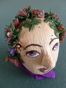
Artwork, other - Sculptured Head Decorated with Beads, Yvonne Walton, "A Fertile Mind", 2010
... "A Fertile Mind"...Soft Sculpture Head Bead Flowers "A Fertile Mind" Artwork, other Sculptured Head Decorated with Beads Yvonne Walton ...This piece was an entrant in the Challenge section of the "Jubilation" exhibition in 2010 to celebrate the 50th anniversary of the Guild and acquired by the Collection . Small sculptured lady's head, embroidered all over and covered as hair with beaded flowers (50) and leaves in pink,mauve, blue and green. Neck is wrapped with purple scarf. Soft Sculpture Head Bead Flowersbead work, embroidery, beading, soft sculpture, australia -
 Lakes Entrance Historical Society
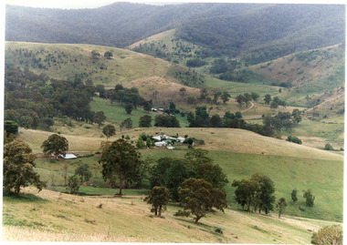
Photograph - Gillingal Station, Tambo Shire, 1994 c
... Colour photograph of Gillingal Station, showing the farm buildings situated on a hillside and surrounded by rising hill country and fertile valleys, cattle grazing in home paddock. ...Lakes Entrance Historical Society 4 Marine Parade Lakes Entrance gippsland Also second identical copy Agriculture Primary industry Colour photograph of Gillingal Station, showing the farm buildings situated on a hillside and surrounded by rising hill country and fertile valleys, cattle grazing in home paddock. ...Also second identical copyColour photograph of Gillingal Station, showing the farm buildings situated on a hillside and surrounded by rising hill country and fertile valleys, cattle grazing in home paddock. Buchan Victoriaagriculture, primary industry -
 Tatura Irrigation & Wartime Camps Museum
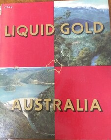
Book, Clive Turnbull, Liquid Gold Australia, 1960
... The story of the most fertile regions of the Victoria: the Goulburn Valley and North Eastern Victoria, the adjoining territory of the Riverina district of NSW and the Snowy Mountains Hydro Electric and Irrigation Scheme....Tatura Irrigation & Wartime Camps Museum 49 Hogan Street Tatura the-murray The story of the most fertile regions of the Victoria: the Goulburn Valley and North Eastern Victoria, the adjoining territory of the Riverina district of NSW and the Snowy Mountains Hydro Electric and Irrigation Scheme. irrigation water goulburn valley north eastern victoria snowy mountains hydro electric scheme Hard Cover. 2 Burgundy blocks and 2 photographs of mountains and water storage on front cover. ...The story of the most fertile regions of the Victoria: the Goulburn Valley and North Eastern Victoria, the adjoining territory of the Riverina district of NSW and the Snowy Mountains Hydro Electric and Irrigation Scheme.Hard Cover. 2 Burgundy blocks and 2 photographs of mountains and water storage on front cover. "Liquid Gold Australia" in gold lettering and map of Australia. 2 Plain burgundy blocks, photograph of power pole and peach trees on back cover.irrigation, water, goulburn valley, north eastern victoria, snowy mountains hydro electric scheme -
 Kew Historical Society Inc
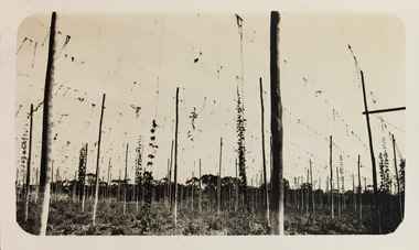
Photograph - Yarra at Kew, 1925
... This photograph of hop farming coveys the various uses for which low lying fertile flood prone land beside the Yarra River was used....This photograph of hop farming coveys the various uses for which low lying fertile flood prone land beside the Yarra River was used. ...Henry Beater Christian (1886-1962) , was a descendant of one of the earliest settler families in Kew. Employed at the Kew Asylum as a 'public servant', he was a skilled amateur photographer, photographing numerous scenes in Kew and on his travels around Victoria. The majority of his photographs date from 1916 to 1929. His finest photographs are housed in two photograph albums. Digital copy of a photograph from page 4 of the 47-page photograph album containing 261 gelatinous silver images, loaned by Diane Washfold with permission given to digitise and hold a copy in our collection. This photograph of hop farming coveys the various uses for which low lying fertile flood prone land beside the Yarra River was used."Yarra at Kew"henry beater christian (1886-1962), landscape photography, kew (vic.) — yarra river, christian-washfold collection, photograph albums, agriculture, hop farms -
 Ballarat Heritage Services
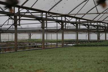
Photograph, L.J. Gervasoni, Horticultural structures, 2017
... ...fertile...Ballarat Heritage Services PO Box 2209 Bakery Hill Post Office goldfields farming horticulture soils floodplain valley fertile structure Plant growing in a large glasshouse. ...Plant growing in a large glasshouse. farming, horticulture, soils, floodplain, valley, fertile, structure -
 Orbost & District Historical Society
Photograph - Flood at Bete Bolong, c.1900-1930s
... Although the township of Orbost was built above the floodplain, much of the really fertile farming land is flood liable. From the earliest days of 'white' settlement (1870s), floods were a fact of life, both a blessing and a liability, often causing severe damage....Although the township of Orbost was built above the floodplain, much of the really fertile farming land is flood liable. From the earliest days of 'white' settlement (1870s), floods were a fact of life, both a blessing and a liability, often causing severe damage. ...This is one of many photographs taken throughout the 20th century of the Snowy River in flood. Although the township of Orbost was built above the floodplain, much of the really fertile farming land is flood liable. From the earliest days of 'white' settlement (1870s), floods were a fact of life, both a blessing and a liability, often causing severe damage.This photograph is significant because it is shows the Snowy River in flood at Bete Bolong. A small b/w photograph showing a river in flood with a number of horses on the right hand side, some are wearing coats. In the background is a crop (possibly maize) and trees both alive and dead.On the back of the photo, handwritten in black ink: 'River in flood, horses on last bit of grass, Bete Bolong'.snowy river, bete bolong, floods -
 Ballarat Heritage Services
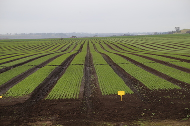
Photograph, Horticulture, 2017
... ...fertile...Ballarat Heritage Services PO Box 2209 Bakery Hill Post Office goldfields farming horticulture soils floodplain valley fertile agriculture food production Colour photograph of a farm paddock Horticulture Photograph L.J. ...Colour photograph of a farm paddockfarming, horticulture, soils, floodplain, valley, fertile, agriculture, food, production -
 Warrnambool and District Historical Society Inc.
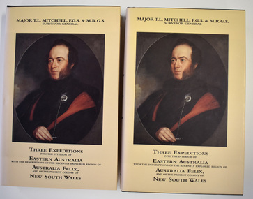
book - Books, Eagle Press, Mitchell's Three Expeditions into Eastern Australia, 1996
... It was a result of his reports of fertile country that led to the influx of squatters in the Western District in the late 1830s and early 1840s. ...It was a result of his reports of fertile country that led to the influx of squatters in the Western District in the late 1830s and early 1840s. ...Major Thomas Mitchell historical writing.This is set number 223 of two facsimile volumes of an historical work. The covers are green with gold printing and the dust covers are cream with black printing and two colour illustrations. The pages contain printed text and illustrations, both black and white and coloured. There are two inserts, one a map and the other showing a New South Wales natural feature. The two volumes are contained in a hardcover green folder.non-fictionMajor Thomas Mitchell historical writing.major mitchell, australia felix squatting period -
 Otway Districts Historical Society
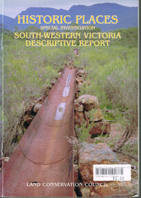
Book, Land Conservation Council, Historic places: Special investigation: South-Western Victoria: Descriptive report, January 1996
... The south-west of Victoria, possessing a rich heritage of the signs of past human activity, is fertile ground for an investigation of historic places on public land. ...Otway Districts Historical Society Cliff Young Drive Beech Forest great-ocean-road The south-west of Victoria, possessing a rich heritage of the signs of past human activity, is fertile ground for an investigation of historic places on public land. ...The south-west of Victoria, possessing a rich heritage of the signs of past human activity, is fertile ground for an investigation of historic places on public land. This report includes an initial inventory of almost 2000 places. The report outlines the history and the related heritage of the area, describes in some detail its biophysical attributes and introduces the natural resources and present land use. This information provides a context for understanding the origins of the historical features that are observes today.Historic places: Special investigation: South-Western Victoria: Descriptive report. Land Conservation Council. Land Conservation Council; Melbourne (Vic); January 1966. viii, 180 p.; illus.; maps. Soft cover. ISBN 0 7241 9288 3Maps in plastic sleeve.land conservation council; conservation; south-western victoria; historic places; -
 Kiewa Valley Historical Society
Photographs – Set of 4 black and white photographs. One of a wooden church and three of rural homes and farmland. Area not identified
... Following the drought of 1838-44, seeking out the rich pastures in the fertile Valleys. It proved to be perfect conditions for dairy farming and the raising of cattle. ...Following the drought of 1838-44, seeking out the rich pastures in the fertile Valleys. It proved to be perfect conditions for dairy farming and the raising of cattle. ...Europeans arrived in the Kiewa and Ovens Valleys in the 1830's and 40's. Following the drought of 1838-44, seeking out the rich pastures in the fertile Valleys. It proved to be perfect conditions for dairy farming and the raising of cattle. Miners Cottages and other similar wooden structures were a common sight in the area as they were a modest form of accommodation for their period, were quick to erect and economical as they made use of locally available building materials such as local timbers.These photographs provide a snapshot into the early dwellings and architecture of the Kiewa and Ovens Valley regions, including buildings such as the church, which provided an important gathering place for social interaction, especially in these isolated areas.1-Wooden church building with no identification. Large tree in the foreground in front of church 2&3- Black and white photographs of farmland and assorted dwellings, mostly miners style cottages in a valley with mountains in the background. A bridge with wooden railings is visible over the river in the middle of the photograph, also a more modern dwelling is visible in the north east of the photograph close to the river. 4-Black and white photograph of residential homes and farmland with an unsealed road running through the middle. Foreground shows a field which has been semi cleared of trees (stumps remaining). In the background are larger farming properties with the road disappearing into the distant hills. This might be Old Tallangatta before the town was moved in 1956. 1-3 - No inscriptions 4- Signature written on back in lead pencil - Sandra Templebuildings; church; farmland -
 Orbost & District Historical Society
stationery, 1930's
... The Orbost area was once a large bean growing area as the fertile snowy River flats produced good quality beans. ...Orbost & District Historical Society Ruskin Street Orbost gippsland The Orbost area was once a large bean growing area as the fertile snowy River flats produced good quality beans. ...The Orbost area was once a large bean growing area as the fertile snowy River flats produced good quality beans. It was exported to other states of Australia. Green beans were sent to Melbourne by train and later to Sydney, either via Bombala where they were railed, or to Eden to continue the journey on fish trucks. One pound per bag was considered a good price in the early 1920's and pickers were paid one shilling and six pence. Ref: Newmerella Valley of PlentyThis stationery is significant because it was specially made for the seed bean industry which was a major industry in the Orbost district for the first half of the 20th century. .1 - 2 letterheads for Orbost Beans and Grains on white paper. .2 - a buff coloured envelope for Orbost Beans and Grains Co-Operative LtdOrbost Beans and Grains Co-operative Ltd (incorporating Gippsland Bean Cleaners)stationery correspondence orbost-beans envelope letterhead -
 Warrnambool and District Historical Society Inc.
Plate Pottery, Serving Plate Parramatta, Late 19th century
... Being within a reasonable distance to the settlement of Sydney and in an area of fertile soil, it soon became a successful farming region. ...Being within a reasonable distance to the settlement of Sydney and in an area of fertile soil, it soon became a successful farming region. ...The settlement of Parramatta is one of the earliest inland settlements in Australia being settled in November 1788 just months after the arrival of the First Fleet to Sydney. Originally named Rose Hill it was given the name Parramatta which closely approximated the original Aboriginal name for the area. Being within a reasonable distance to the settlement of Sydney and in an area of fertile soil, it soon became a successful farming region. It was proclaimed a city in 1938. This plate possibly belongs to either the commemoration of 100 or 150 years of settlement of the area, although the stamp on the plate is the same drawing as that on the official invitation for 1938While this plate has no local historical links , it does have significance belonging to one of the earliest settlements in Australia.White oval plate with fluted edge with gold on rim. Small orange stamp on one edge.Parramatta 2 Nov 1788 on one edge of plate. Stamp on back: Grimwades Staffordshire England Upper Hanley Pottery. Semi porcelainwarrnambool, parramatta, serving plate -
 Kiewa Valley Historical Society
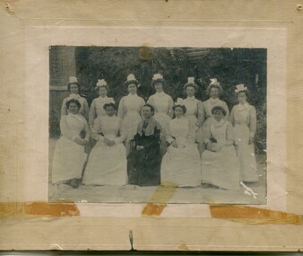
Photographs – Group of 3 old sepia photographs, 2 of women in period costume and 1 of group of nurses from Sunbury sanatorium
... Following the drought of 1838-44 seeking out the rich pastures in the fertile Kiewa Valley. . The next major increase in population was as a result of the Kiewa Hydro Scheme. ...Following the drought of 1838-44 seeking out the rich pastures in the fertile Kiewa Valley. . The next major increase in population was as a result of the Kiewa Hydro Scheme. ...Europeans arrived in the Kiewa Valley in the 1830s and 40s. Following the drought of 1838-44 seeking out the rich pastures in the fertile Kiewa Valley. . The next major increase in population was as a result of the Kiewa Hydro Scheme. The beginning of construction of the Kiewa Hydro-electric scheme in the late 1940s introduced changes and led to the enlargement and improvement of local roads and the townships of Mount Beauty and Bogong Village were constructed by the SECV from the 1930’s to the 1950’s to house workers on the Kiewa Hydro Electric Scheme. At its peak the Kiewa Scheme employed around 4000 people from all walks of life and as many cultures.The influx of European migrants to work on the Hydro Scheme along with their rich cultural backgrounds, all played a major part in establishing the history of the area and in shaping the future character of the Mount Beauty, the Kiewa Valley and Falls Creek areas. Photographs may depict descendants, family or friends of early settlers or workers in the Kiewa Valley region.1. Sepia photograph, mounted on heavy buff card with yellowing marks from sticking tape across the bottom of the photograph. Photograph is of a group of nurses taken at the Sunbury Sanitorium 2. Sepia photograph mounted on heavy buff card with yellowing marks from sticking tape at top and bottom of photo. Mark from drawing pin in centre top of photo. Photograph is of a middle aged woman posing dressed in period costume 3. Sepia photograph mounted on heavy buff card with yellowing marks from sticking tape at top and bottom of photo. Mark from drawing pin in centre top of photo. Photograph is of an older woman posing dressed in period costume sepia photos; nurses; kiewa valley; sunbury sanitorium; period costume -
 Narre Warren and District Family History Group
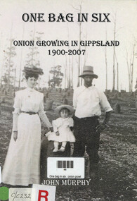
Book, John Murphy, One bag in six : onion growing in Gippsland 1900-2007, 2007
... This region became a hub for onion farming due to its fertile soil and favorable climate. The title refers to the early challenges faced by farmers, where only one bag of onions out of six was of marketable quality—a testament to the difficulties of establishing a viable onion-growing industry. ...This region became a hub for onion farming due to its fertile soil and favorable climate. The title refers to the early challenges faced by farmers, where only one bag of onions out of six was of marketable quality—a testament to the difficulties of establishing a viable onion-growing industry. ...The book explores the history of onion farming in South Gippsland, Victoria. It delves into the establishment of a viable onion-growing industry in the region, highlighting the challenges and successes faced by farmers over more than a century. [AI generated text]97 p.; 21 cmnon-fictionThe book explores the history of onion farming in South Gippsland, Victoria. It delves into the establishment of a viable onion-growing industry in the region, highlighting the challenges and successes faced by farmers over more than a century. [AI generated text] onion industry -- victoria -- gippsland region -- history, onions -- victoria -- gippsland region -- history, gippsland region (vic.) -- history -
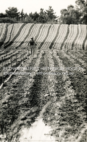 Eltham District Historical Society Inc
Photograph, George W. Bell, Fabbro's Market Garden, South Eltham, 1960s
... When times became tough and vegetables were no longer bringing in the money, Maurie started selling the fertile top soil. He scraped much of the top soil into mounds and these mounds are now visible, covered in grass as one walks along the Diamond Creek Trail through there....When times became tough and vegetables were no longer bringing in the money, Maurie started selling the fertile top soil. He scraped much of the top soil into mounds and these mounds are now visible, covered in grass as one walks along the Diamond Creek Trail through there. farming market gardens eltham eltham south fabbro falkiner street george w bell collection Two black and white photographs 1. ploughed land Fabbro's market garden Eltham South c.1960s 2. field of crops 1970 Fabbro's Market Garden, South Eltham Photograph George W. ...Fabbro's market garden. Much of the creek side land is now called Barrak Bushlands, a title that is fairly recent after the Shire of Eltham purchased the land, including the last section in 1993/94. About this time the area on the west side of Falkiner Street was purchased by a private developer and developed as housing. The area in Bell Street opposite the Eltham High School was purchased by the State Government is recent years and is called Fabbro Fields. When times became tough and vegetables were no longer bringing in the money, Maurie started selling the fertile top soil. He scraped much of the top soil into mounds and these mounds are now visible, covered in grass as one walks along the Diamond Creek Trail through there.Two black and white photographs 1. ploughed land Fabbro's market garden Eltham South c.1960s 2. field of crops 1970farming, market gardens, eltham, eltham south, fabbro, falkiner street, george w bell collection -
 Greensborough Historical Society
Photograph - Digital Image, Art at WaterMarc, July 2017, 22/07/2017
... This area's exceptionally fertile soil [used by] by white settlers for farms, market gardens and orchards reshaped the Wurundjeri's traditional lands - and today the private sale and division of these farms informs the streetscape and town plan. ...This area's exceptionally fertile soil [used by] by white settlers for farms, market gardens and orchards reshaped the Wurundjeri's traditional lands - and today the private sale and division of these farms informs the streetscape and town plan. ...Photographs of an art installation by Jessie Stanley at WaterMarc Greensborough on 22/07/2017. From Jessie Stanley's FaceBook page :Dust to Dust is complete... It's an ephemeral site-specific work about how the Melbourne suburb of Greensborough has transformed over time. This area's exceptionally fertile soil [used by] by white settlers for farms, market gardens and orchards reshaped the Wurundjeri's traditional lands - and today the private sale and division of these farms informs the streetscape and town plan. With soil sourced locally this work reveals some of the area’s history - the text running around the perimeter was written by former resident Val Wilson, a snippet of her recollections of growing up in the area in the 1950s. The arrows and text act like a compass to orientate this site with greater Melbourne. On display in the lobby of Banyule Council until chance, time (or a broom) sweeps it away, Many thanks to Banyule City Council, Greensborough Historical Society and Valerie Wilson. "An artistic representation of Greensborough's history.Digital photographs of art installation.jessie stanley, watermarc, greensborough historical society, banyule council -
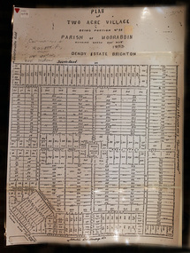 City of Moorabbin Historical Society (Operating the Box Cottage Museum)
Document,photocopy plan 'Two Acre Village 'c1852, c1960
... The early settlers, who were predominantly English and Scottish immigrants initially leased their allotments and, because the sandy soil was so fertile, they were soon able to purchase the land and increase their acreage. ...The early settlers, who were predominantly English and Scottish immigrants initially leased their allotments and, because the sandy soil was so fertile, they were soon able to purchase the land and increase their acreage. ...In the 1852 Josiah Holloway, a developer, purchased 625 acres from the squatters Richard and John King and sectioned '2 acre allotments' south of Henry Dendy's Brighton Survey along the Arthur's Seat Road ( later Nepean Highway) for sale @ £10 It became known as The Two Acre Village as settlers took up the allotments and established market gardens, general stores, butchers, blacksmiths, post office and 2 hotels. Charles Whorral opened The Cheltenham Inn and it became so popular as a meeting place that the area was called Cheltenham. The early settlers, who were predominantly English and Scottish immigrants initially leased their allotments and, because the sandy soil was so fertile, they were soon able to purchase the land and increase their acreage. Cheltenham became a very important part of the large Moorabbin Shire1871 and City of Moorabbin 1934 In the 1994 Amalgamation of Councils, when the large City of Moorabbin was divided between the newly formed Glen Eira, Kingston and Bayside Councils, the Cheltenham area was assigned to the City of Kingston A photocopy of the Plan for the 2 Acre Village in Moorabbin Parish c1852. A3 laminatedmoorabbin, brighton, cheltenham, market gardeners, pioneers, early settlers, , king. john, holloway josiah, whorral charles, arthur’s seat road, nepean highway , cheltenham inn hotel, henry dendy special survey 1841 -
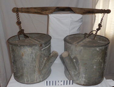 City of Moorabbin Historical Society (Operating the Box Cottage Museum)
Tool - Chinese Market-Gardener's Watering-Cans
... A significant number of Chinese men, realising the potential of the sandy, fertile soil, with a good supply of water, in the Shire of Moorabbin, leased tracts of land in that area to establish a market garden and grow produce for the increasing population of Melbourne...A significant number of Chinese men, realising the potential of the sandy, fertile soil, with a good supply of water, in the Shire of Moorabbin, leased tracts of land in that area to establish a market garden and grow produce for the increasing population of Melbourne After the Dendy Special Survey in1841in Brighton, Victoria, the first sale of Crown Land, taking in the whole Shire of Moorabbin, occurred in 1852. ...Chinese market-gardener’s watering-cans on a wooden yoke. This item was authenticated by the Bendigo Historical Society, and is said to be quite rare. It consists of two large galvanized watering-cans each with a pouring spout, suspended by chains from a well-used wooden yoke. The cans would each have been filled with water, then carried a distance into the market garden and used to water crops. The cans and yoke alone are very heavy, one can only imagine how heavy they were when filled with water.As profits from the gold-fields petered out the Chinese immigrants, (nearly all single men), were forced to seek other occupations. Many moved into furniture building in the East Melbourne area, whilst others went into market gardening . A significant number of Chinese men, realising the potential of the sandy, fertile soil, with a good supply of water, in the Shire of Moorabbin, leased tracts of land in that area to establish a market garden and grow produce for the increasing population of MelbourneAfter the Dendy Special Survey in1841in Brighton, Victoria, the first sale of Crown Land, taking in the whole Shire of Moorabbin, occurred in 1852. These allotments of land were eagerly bought up - some by speculators - although many were either worked by the owner, or leased out as market gardens and "fruit gardens", (orchards). Chinese market-gardener’s watering-cans suspended by chains on a wooden yoke. This item was authenticated by the Bendigo Historical Society, and is said to be quite rare. It consists of two large galvanized watering-cans each with a pouring spout, suspended by chains from a well-used wooden yokebrighton, gardeners, bentleigh, orchards, vegetables, dendy henry, market gardens, chinese settlers, pioneers moorabbin, water wells, creeks -
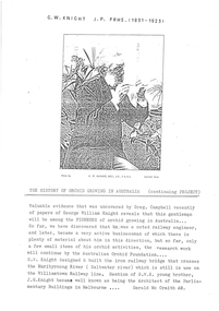 Bendigo Historical Society Inc.
Document - George William Knight, Australian Orchid Foundation, 16.10.2003
... The Rosenberg nursery at Back Creek was established on former gold diggings - only after turning over the whole site to unearth the fertile soil and bury the clay and gravel that the miners had brought to the surface. ...The Rosenberg nursery at Back Creek was established on former gold diggings - only after turning over the whole site to unearth the fertile soil and bury the clay and gravel that the miners had brought to the surface. ...George Knight was born in London in 1831. He qualified as an architect and practised as a civil engineer before coming to Australia with a younger brother in 1854. He was appointed Government Engineer shortly after arriving in Victoria, and supervised the construction of a railway line to Williamstown and the Sunbury section of the main railway line to Bendigo. Subsequently, he established a vineyard at Sunbury but soon sold it and moved to Bendigo, where he held the position of City Surveyor until retiring in 1886. During that period, he established nurseries, vineyards and orchards on four different sites in and around Bendigo, trading as the Knight Brothers. The Rosenberg nursery at Back Creek was established on former gold diggings - only after turning over the whole site to unearth the fertile soil and bury the clay and gravel that the miners had brought to the surface. One of the noteworthy plants at the nursery was a rose 'bush' measuring 19 metres long, 13 metres wide and 4 metres high. Another was the 'Grand Centennial' grape vine, bred from a Waltham cross, that yielded grapes measuring 35 mm long and 28 mm in diameter. It won a silver medal for the 'newest and finest grape variety raised in the colony' at the Melbourne Centennial Exhibition in 1895.Four page photocopied document, includes letter from Australian Orchid Foundation (16/10/2003) addressed to the Bendigo Historical Society re George William Knight, seeking a copy of a portrait of Knight; one page article on Knight and his role as a pioneer of orchid growing in Australia (by Gerald McCraith, AM) and a two page article titled 'George W. Knight, one of Victoria's earliest orchid growers, by Greg Campbell, Gerald McCraith AM and Brian Milligan.george william knight, bendigo, nursery, rosenberg nursery, back creek, grapes, roses, orchids -
 Eltham District Historical Society Inc
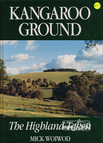
Book, Tarcoola, Kangaroo Ground: The Highland Taken by Mick Woiwod, 1994
... ." -- Diamond Valley News November 16, 1994 This major history of Kangaroo Ground details the district’s story between 1841 and 1994, describing it as having been unique in the Yarra Valley in that its early settlers were all Scottish and its soils were more fertile than those of surrounding districts. ...." -- Diamond Valley News November 16, 1994 This major history of Kangaroo Ground details the district’s story between 1841 and 1994, describing it as having been unique in the Yarra Valley in that its early settlers were all Scottish and its soils were more fertile than those of surrounding districts. ..."A piece of Scotland in the Australian bush is how author Mick Woiwod describes the "Village" of Kangaroo Ground. Settled in 1841 by a Scottish family, the Donaldsons, the town is the feature of Mrs Woiwod's latest book, "Kangaroo Ground - The Highland Taken" The book follows the history of Kangaroo Ground, from its beginnings as an exclusively Scottish farming community in the middle of nowhere to a town that became the centre of the Yarra Valley region... It took Mr Woiwod six months of intensive research and nine months to write the book on Kangaroo Ground. He spent much of his time searching archives, public records and newspaper files for detailed information on the characters who colour his book." -- Diamond Valley News November 16, 1994 This major history of Kangaroo Ground details the district’s story between 1841 and 1994, describing it as having been unique in the Yarra Valley in that its early settlers were all Scottish and its soils were more fertile than those of surrounding districts. Their soil gave them the sort of power that saw the then extensive Shire of Eltham governed from little Kangaroo Ground for a remarkable 69 years. The author describes the Kangaroo Ground landscape that these farmers worked in the early period as having been already significantly modified by Aboriginal fire-stick farming before their arrival. This publication is a significant title in the recording of the early history of the pioneers of the small area of Kangaroo Ground, VictoriaHardback Book, 312 pagesISBN 0646209000kangaroo ground, mick woiwod, pioneers, donaldson family, thomson family -
 Federation University Historical Collection
Ammeter, Henry Sutton (probably), Ammeter attributed to Henry Sutton, 1883 (estimated)
... Sutton had an active and fertile brain, and was known for his inventions, especially his work on the telephone, telephane and carbon lamps. ...Sutton had an active and fertile brain, and was known for his inventions, especially his work on the telephone, telephane and carbon lamps. ...W.B Withers wrote of Sutton: "In the realm of science Ballarat has become of world-wide fame through the inventions by Mr Henry Sutton, a native of the place. His skill and acquirements in electricity, telegraphy, telephony, photography and also in astronomical and microscopal studies have won for him a high position as a practical scientist, and the credit is the greater as he is a self-taught student … Mr Sutton, before he was fourteen years old, had read every book on science to be found in the library of the Ballarat Mechanics' Institute." The Ballarat School of Mines (SMB) was fortunate to have this genius appointed as the lecturer-in-charge of the new Electricity and Magnetism department from 23 April 1883. Although Henry Sutton submitted his resignation to the Council of SMB in October 1884 it was resolved that he be asked to reconsider, and Mr Sutton continued to teach at SMB until the end of 1886. He was a prominent member of the Camera Club, and many of the other SMB clubs. Sutton had an active and fertile brain, and was known for his inventions, especially his work on the telephone, telephane and carbon lamps. Sutton presented a vacuum pump, worked by water jet, for use in SMB Chemistry classes. His report of 1883 states: ‘A telephonic circuit has been laid down between the [SMB] engine-house and workshops, to be used for experimental purposes.’ Henry Sutton spent much thought on artificial flight, and made some interesting experimental studies with flying birds. The storage of electricty also attracted his attention, and, after much work and thought evolved the Sutton Secondary Battery. A paper on this battery was presented to the Royal Society, London, and was afterwards printed in the 'Transactions'. Henry Sutton is listed on the Federation University Honour Roll at https://www.federation.edu.au/curator/honour-roll/honourroll_sutton.shtmlA crude scientific instrument that measures amps, with a timber base and frame. Terminal posts and sliders contacts are positioned on top of the base, with flex attached. Henry Sutton lectured at the Ballarat School of Mines (SMB) in Electricty and Magnestism between 1883 and 1886. In 1883 Sutton reported: ‘…The class has been unfortunately situated, by having to wait for instruments of precision ordered from England, but which have not come to hand. The delay has caused us to start constructing instruments, which it is hoped will bear favourable comparison with those of older date.'ammeter, henry sutton, electrical, inventor, electricity and magnetism, sutton, scientific instruments -
 City of Moorabbin Historical Society (Operating the Box Cottage Museum)
Document - Genealogy Chart Henry Dendy (Photocopy), 19 thC
... Legend records Moorabbin is named after the Aboriginal word for ' Mother's Milk ' The soil is very fertile and well supplied with water especially in the area called 'East Brighton' - now known as Bentleigh and East Bentleigh - By 1850 the area had developed with numerous market gardens, dairy farms, fruit gardens and vineyards supplying food for the growing population of Melbourne....Legend records Moorabbin is named after the Aboriginal word for ' Mother's Milk ' The soil is very fertile and well supplied with water especially in the area called 'East Brighton' - now known as Bentleigh and East Bentleigh - By 1850 the area had developed with numerous market gardens, dairy farms, fruit gardens and vineyards supplying food for the growing population of Melbourne. ...In 1840 Henry Dendy, a farmer in Surrey, England acquired a "Special Survey" from the Commissioners for Land and Emigration which gave Dendy the right to choose land in Port Phillip for the "bargain basement" price of only £1 per acre for 5120 acres, (an area of 8 square miles). The Special Survey also included the right to "the shipment of a worker for every £20 spent on land, whose free passage was paid by the Crown, equalling a total of 100 workers ". Accordingly Dendy sold his English holdings and paid the required £5120 and arrived in Melbourne in February 1841. However by this time land in the new colony was selling for £5 - £40 per acre. Because Henry Dendy possessed the order from the Colonial Office in London he was able to successfully oppose Super-intendant LaTrobe's attempts to alter the price of the land. Dendy appointed Jonathan Were, (an entrepreneur, who had arrived in 1839), as his Manager and who later became a partner. Together, Dendy and Were decided on an area 5 miles south from Melbourne, bounded by North Road, East Boundary Road, South Road and to the west by Port Phillip Bay. Were and Dendy pitched their tents in the area now known as ' Park St, Brighton' and sank a well near the corner of 'St Andrew's St and Wells St'. By 1845 J.B Were and Company had bought almost half of Dendy's land and Were built himself "Moorabbin House" in Were St Brighton made from stone, quarried from local cliffs. It was still standing in 1924. Legend records Moorabbin is named after the Aboriginal word for ' Mother's Milk ' The soil is very fertile and well supplied with water especially in the area called 'East Brighton' - now known as Bentleigh and East Bentleigh - By 1850 the area had developed with numerous market gardens, dairy farms, fruit gardens and vineyards supplying food for the growing population of Melbourne.In 1840 Henry Dendy, a farmer in Surrey, England acquired a "Special Survey" from the Commissioners for Land and Emigration which gave Dendy the right to choose land in Port Phillip for the price of only £1 per acre for 5120 acres. This land was called Brighton in the Parish of Moorabbin, County of Bourke and emigrants developed the land establishing market gardens , dairy and poultry farms that provided the food for the growing population of Melbourne. A photocopy of the Genealogy Chart of the Dendy Family that Henry Dendy brought with him when he emigrated to Melbourne 1841Genealogy signs and descriptionsdendy henry, dendy's special survey brighton 1841, governor gipps, captain lonsdale, super-intendant latrobe, port phillip, melbourne, new south wales, squatters, emmigrants, county of bourke, parish of moorabbin, early settlers, pioneers, market gardeners, dairy farmers, fruit farms, moorabbin, bentleigh, brighton, cheltenham, were jonathan binn, -
 City of Moorabbin Historical Society (Operating the Box Cottage Museum)
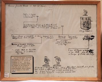
Document, Henry Dendy family Shield
... Legend records Moorabbin is named after the Aboriginal word for ' Mother's Milk ' The soil is very fertile and well supplied with water especially in the area called 'East Brighton' - now known as Bentleigh and East Bentleigh - By 1850 the area had developed with numerous market gardens, dairy farms, fruit gardens and vineyards supplying food for the growing population of Melbourne. ...Legend records Moorabbin is named after the Aboriginal word for ' Mother's Milk ' The soil is very fertile and well supplied with water especially in the area called 'East Brighton' - now known as Bentleigh and East Bentleigh - By 1850 the area had developed with numerous market gardens, dairy farms, fruit gardens and vineyards supplying food for the growing population of Melbourne. dendy henry, dendy's special survey brighton 1841, governor gipps, captain lonsdale, super-intendant latrobe, port phillip, melbourne, new south wales, squatters, emmigrants, county of bourke, parish of moorabbin, early settlers, pioneers, market gardeners, dairy farmers, fruit farms, moorabbin, bentleigh, brighton, cheltenham, were jonathan binn, Document, Henry Dendy family Shield ...In 1840 Henry Dendy, a farmer in Surrey, England acquired a "Special Survey" from the Commissioners for Land and Emigration which gave Dendy the right to choose land in Port Phillip for the "bargain basement" price of only £1 per acre for 5120 acres, (an area of 8 square miles). The Special Survey also included the right to "the shipment of a worker for every £20 spent on land, whose free passage was paid by the Crown, equalling a total of 100 workers ". Accordingly Dendy sold his English holdings and paid the required £5120 and arrived in Melbourne in February 1841. However by this time land in the new colony was selling for £5 - £40 per acre. Because Henry Dendy possessed the order from the Colonial Office in London he was able to successfully oppose Super-intendant LaTrobe's attempts to alter the price of the land. Dendy appointed Jonathan Were, (an entrepreneur, who had arrived in 1839), as his Manager and who later became a partner. Together, Dendy and Were decided on an area 5 miles south from Melbourne, bounded by North Road, East Boundary Road, South Road and to the west by Port Phillip Bay. Were and Dendy pitched their tents in the area now known as ' Park St, Brighton' and sank a well near the corner of 'St Andrew's St and Wells St'. By 1845 J.B Were and Company had bought almost half of Dendy's land and Were built himself "Moorabbin House" in Were St Brighton made from stone, quarried from local cliffs. It was still standing in 1924. Legend records Moorabbin is named after the Aboriginal word for ' Mother's Milk ' The soil is very fertile and well supplied with water especially in the area called 'East Brighton' - now known as Bentleigh and East Bentleigh - By 1850 the area had developed with numerous market gardens, dairy farms, fruit gardens and vineyards supplying food for the growing population of Melbourne. dendy henry, dendy's special survey brighton 1841, governor gipps, captain lonsdale, super-intendant latrobe, port phillip, melbourne, new south wales, squatters, emmigrants, county of bourke, parish of moorabbin, early settlers, pioneers, market gardeners, dairy farmers, fruit farms, moorabbin, bentleigh, brighton, cheltenham, were jonathan binn, -
 City of Moorabbin Historical Society (Operating the Box Cottage Museum)
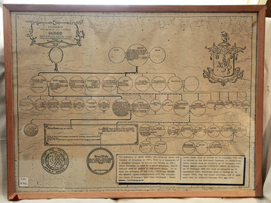
Document - Pedigree of Henry Dendy, c1840 Original ; Copy 1985
... Legend records Moorabbin is named after the Aboriginal word for ' Mother's Milk ' The soil is very fertile and well supplied with water especially in the area called 'East Brighton' - now known as Bentleigh and East Bentleigh - By 1850 the area had developed with numerous market gardens, dairy farms, fruit gardens and vineyards supplying food for the growing population of Melbourne. ...Legend records Moorabbin is named after the Aboriginal word for ' Mother's Milk ' The soil is very fertile and well supplied with water especially in the area called 'East Brighton' - now known as Bentleigh and East Bentleigh - By 1850 the area had developed with numerous market gardens, dairy farms, fruit gardens and vineyards supplying food for the growing population of Melbourne. moorabbin brighton henry dend special survey 1841 y early settlers pioneers market gardeners Pedigree / of the branch of the family / DENDY A copy of a paper chart of the Pedigree of Henry Dendy in a wooden frame with glass Document Pedigree of Henry Dendy Unrecorded Genealogist ...This is a copy of the document brought by Henry Dendy to the Colony in 1841. In 1840 Henry Dendy, a farmer in Surrey, England acquired a "Special Survey" from the Commissioners for Land and Emigration which gave Dendy the right to choose land in Port Phillip for the "bargain basement" price of only £1 per acre for 5120 acres, (an area of 8 square miles). The Special Survey also included the right to "the shipment of a worker for every £20 spent on land, whose free passage was paid by the Crown, equalling a total of 100 workers ". Accordingly Dendy sold his English holdings and paid the required £5120 and arrived in Melbourne in February 1841. However by this time land in the new colony was selling for £5 - £40 per acre. Because Henry Dendy possessed the order from the Colonial Office in London he was able to successfully oppose Super-intendant LaTrobe's attempts to alter the price of the land. Dendy appointed Jonathan Were, (an entrepreneur, who had arrived in 1839), as his Manager and who later became a partner. Together, Dendy and Were decided on an area 5 miles south from Melbourne, bounded by North Road, East Boundary Road, South Road and to the west by Port Phillip Bay. Were and Dendy pitched their tents in the area now known as ' Park St, Brighton' and sank a well near the corner of 'St Andrew's St and Wells St'. By 1845 J.B Were and Company had bought almost half of Dendy's land and Were built himself "Moorabbin House" in Were St Brighton made from stone, quarried from local cliffs. It was still standing in 1924. Legend records Moorabbin is named after the Aboriginal word for ' Mother's Milk ' The soil is very fertile and well supplied with water especially in the area called 'East Brighton' - now known as Bentleigh and East Bentleigh - By 1850 the area had developed with numerous market gardens, dairy farms, fruit gardens and vineyards supplying food for the growing population of Melbourne. A copy of a paper chart of the Pedigree of Henry Dendy in a wooden frame with glassPedigree / of the branch of the family / DENDY moorabbin, brighton, henry dend special survey 1841 y, early settlers, pioneers, market gardeners -
 City of Moorabbin Historical Society (Operating the Box Cottage Museum)
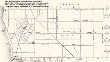
Photograph - Map of Dendy's Special Survey, 1852 Map of Henry Dendy's Special Survey of 1841, 19th Century
... Legend records Moorabbin is named after the Aboriginal word for ' Mother's Milk ' The soil is very fertile and well supplied with water especially in the area called 'East Brighton' - now known as Bentleigh and East Bentleigh - By 1850 the area had developed with numerous market gardens, dairy farms, fruit gardens and vineyards supplying food for the growing population of Melbourne....Legend records Moorabbin is named after the Aboriginal word for ' Mother's Milk ' The soil is very fertile and well supplied with water especially in the area called 'East Brighton' - now known as Bentleigh and East Bentleigh - By 1850 the area had developed with numerous market gardens, dairy farms, fruit gardens and vineyards supplying food for the growing population of Melbourne. ...A Map drawn in 1852 that shows the 5,120 acres that formed Dendy's Special Survey of 1841. In 1840 Henry Dendy, a farmer in Surrey, England acquired a "Special Survey" from the Commissioners for Land and Emigration which gave Dendy the right to choose land in Port Phillip for the "bargain basement" price of only £1 per acre for 5120 acres, (an area of 8 square miles). The Special Survey also included the right to "the shipment of a worker for every £20 spent on land, whose free passage was paid by the Crown, equalling a total of 100 workers ". Accordingly Dendy sold his English holdings and paid the required £5120 and arrived in Melbourne in February 1841. However by this time land in the new colony was selling for £5 - £40 per acre. Because Henry Dendy possessed the order from the Colonial Office in London he was able to successfully oppose Governor LaTrobe's attempts to alter the price of the land. Dendy appointed Jonathan Were, (an entrepreneur, who had arrived in 1839), as his Manager and who later became a partner. Together, Dendy and Were decided on an area 5 miles south from Melbourne, bounded by North Road, East Boundary Road, South Road and to the west by Port Phillip Bay. Were and Dendy pitched their tents in the area now known as ' Park St, Brighton' and sank a well near the corner of 'St Andrew's St and Wells St'. By 1845 J.B Were and Company had bought almost half of Dendy's land and Were built himself "Moorabbin House" in Were St Brighton made from stone, quarried from local cliffs. It was still standing in 1924. Legend records Moorabbin is named after the Aboriginal word for ' Mother's Milk ' The soil is very fertile and well supplied with water especially in the area called 'East Brighton' - now known as Bentleigh and East Bentleigh - By 1850 the area had developed with numerous market gardens, dairy farms, fruit gardens and vineyards supplying food for the growing population of Melbourne.This Map shows the birth of the Brighton and Moorabbin area. On 18th January1859 Brighton was proclaimed a Municipality and a Borough by October 1863. Meanwhile, following a Petition, the area of East and South Brighton, incorporating Mordialloc, Cheltenham, Mentone, Sandringham and Oakleigh separated from Brighton to form the Moorabbin District Roads Board becoming the first Local Government Authority. Col. William Mair was elected as the first Chairman of the Moorabbin Roads Board. Moorabbin Shire 1871 developed further and was declared a City in1934. The City of Moorabbin was the largest Municipality in Melbourne before the Amalgamation of Councils in 1994 when it was divided in the south to City of Kingston and in the north to City of Glen Eira A Photo-lithographed 1852 Map showing the 5,120 acres that formed Dendy's Special Survey of 1841. Henry Dendy & Jonathan Were chose an area 5 miles south from Melbourne, bounded by North Road, East Boundary Road, South Road and to the west by Port Phillip Bay. Moorabbin County of Bourke / Photo-Lithographed at the department of Lands and Survey. /Melbourne. / Price 1/- brighton, moorabbin, bentleigh, cheltenham, dendy henry, bent thomas, were jonathan, special survey -
 Halls Gap & Grampians Historical Society
Magazine - B/W, C 1915
... Perhaps the independence won by women as they carried on their daily lives without their men, made mothers say, "Enough" The Warren family farmed the fertile Fyans Creek flats in the Grampian Mountains of Western Victoria. ...Perhaps the independence won by women as they carried on their daily lives without their men, made mothers say, "Enough" The Warren family farmed the fertile Fyans Creek flats in the Grampian Mountains of Western Victoria. ...Large families were the norm, rather than the exception up to the time of the World wars. perhaps the senseless destruction of those young lives sickened humanity- perhaps the increased taxes and cost of living resulting from the wars caused a necessary reduction in family size. Perhaps the independence won by women as they carried on their daily lives without their men, made mothers say, "Enough" The Warren family farmed the fertile Fyans Creek flats in the Grampian Mountains of Western Victoria. Some say Halls Gap was so named because the bushranger Hall holed up there in the early days. The rugged slopes and hidden gullies could have hidden a whole gang of bushrangers, but little remained undiscovered to a wandering family of 12 children growing up with their flocks and herds grazing the ranges. A tired rider could nod off, safe in the knowledge a trusty stockhorse would plod steadily homeward into the night. Responsibility quickly made youngsters capable and reliable. Then Australia went to war. There were three older brothers, then the girls, then young Frank. All the men went, including Frank. So the girls had to run the farm alone. Their mother had her hands full with the youngsters, still attending school, a daily walk over the mountain to Pomonal and return. But the loss of the men's casual wages from timber cutting and labouring jobs, meant great hardship is some method of earning a cash income had to be devised. Paying guests! That was it. So Myrtle Bank Guest House was born. City folk flocked to the mountain resort. High stepping mountain horses met them at the Stawell raid-head, with the tall and beautiful Warren girls driving them in experienced fashion, their auburn hair sometimes falling from its pins to fly free, as the dray bowled along towards the hills. The would hitch up their skirts to saw and chop wood for the stoves and fires. They milked cows and delivered calves. They shore sheep and trimmed their feet. They mustered their cattle as the seasons rolled by, and the paying guests watched and participated, fascinated. With laughter and song, the girls would wash up in a tin dish, throw on their house clothes to wait on table, sing and play piano, violin, accordion, enjoying the talk of the city and that other world so far away from their mountain home. The simple country menu was a hit, and the homemade bread, butter, jams and preserves, fruit and vegetables sent guests staggering to their armchairs. Picnics, hikes, goodbyes and welcomes blurred as the years of the war dragged by. Bookings were made and remade as the new enterprise became established. Peace was declared. the men returned A whole new building rose with two floors, inviting verandahs and bathrooms. Myrtle Bank would remain a family business all its lifetime, until buried below the Bellfield Dam, by which time more than one the girls had joined their beloved Frank, lost on Flanders Field. Article in book or magazine describing life at Myrtlebank during war years Other article written from letter from soldier P Lillis to his sister 3rd article of woman from country enlisting in WAAF Submitted by Carol of Bannockburn, Submitted by D Langley Submitted by Meryl of South Frankstonaccommodation, myrtlebank, people, warren -
 Eltham District Historical Society Inc
Photograph, Fay Bridge, Moor-rul Viewing Platform, Garden Hill, Kangaroo Ground, n.d
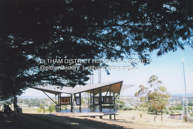
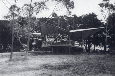
... The platform has been given the name Moor-rut, a name which described the fertile soils of the Kangaroo Ground area in contrast to the poorer (Silurian) country of its surrounds, which the Wurundjeri knew as 'Nillumbik' or less rich country. ...The platform has been given the name Moor-rut, a name which described the fertile soils of the Kangaroo Ground area in contrast to the poorer (Silurian) country of its surrounds, which the Wurundjeri knew as 'Nillumbik' or less rich country. ...OPENING OF THE VIEWING PLATFORM AT KANGAROO GROUND Nillumbik Council has advised that the viewing platform at Kangaroo Ground 27km NE of Melbourne is to be opened to the public on Wednesday, March 26th 2008 (Melway 271 , G10). The function of the platform is to provide shelter adjacent to the War Memorial Tower whilst allowing all people to enjoy the stunning panoramic views. From the platform you. can see the Dandenongs, the city of Melbourne, the You Yangs, Mount Macedon, the Kinglake Ranges and the Mt Baw-Baw Ranges where the Yarra River starts. This landscape covers all the ancestral lands of the Wurundjeri and some of the wider Kulin nation land. The platform has been given the name Moor-rut, a name which described the fertile soils of the Kangaroo Ground area in contrast to the poorer (Silurian) country of its surrounds, which the Wurundjeri knew as 'Nillumbik' or less rich country. The full 360 degree view can be seen from the adjacent Tower of Remembrance which has 53 stairs. The viewing platform however can be accessed by wheelchair. Inside the viewing platform there are eight double sided interpretive panels giving the history and information regarding this special area. The viewing platform's interpretive panels set out the Aboriginal and European history of the area and also the geology and the local flora and fauna, so that the casual visitor comes away understanding more about this significant part of Victoria. The concept of the viewing platform is part of the refurbishment project for the Kangaroo Ground War Memorial Park which has taken place since 1997 with the active approval and financial assistance of the Nillumbik Shire Council. This project has been guided by an Advisory Committee with volunteer community representatives from the local Historical Societies, the Country Fire Authority, the Returned Services League and the Wurundjeri people. Other allied groups such as the Nillumbik Reconciliation Group have been called upon for their expertise. The initial idea for the viewing platform came from Dean Stewart when he was the caretaker while living at the park. He discussed this idea with local author Mick Woiwod and Harry Gilham of Eltham District Historical Society when they were planning the refurbishment of the War Memorial Park in 1996. When the committee was formalised by the Nillumbik Council in 1997, Nicholas Pelling, representing the CFA and RSL, joined the group. Dennis Ward, local architect, then volunteered to develop the concept plan for the refurbishment of the park and later drew up the plans for the viewing platform. The Kangaroo Ground War Memorial Park and its Tower of Remembrance is located on one of the highest locations in the Yarra Valley. The Tower of Remembrance is a unique war memorial constructed from local stone standing 14 metres high. It was built in the style of a Scottish watchtower reflecting the strong Scottish influence of the first European settlers of the district from the 1840s onward. The park was opened in 1921 and the Tower of Remembrance was dedicated in 1926 recognising the local people who served in the First World War. Those who served in the Second World War were recognised by plaques dedicated in 1951 and more recently those who served in Korea, Borneo, Malaya and Vietnam by plaques unveiled in 2001. Harry Gilham, Advisory Committee Convenor - Eltham District Historical Society Newsletter N0 179 March 2008fay bridge collection, garden hill, kangaroo ground, memorial park, moor-rul viewing platform -
 Eltham District Historical Society Inc
Photograph - Black and White Print, Moor-rul Viewing Platform, March 2007
... The platform has been given the name Moor-rut, a name which described the fertile soils of the Kangaroo Ground area in contrast to the poorer (Silurian) country of its surrounds, which the Wurundjeri knew as 'Nillumbik' or less rich country. ...The platform has been given the name Moor-rut, a name which described the fertile soils of the Kangaroo Ground area in contrast to the poorer (Silurian) country of its surrounds, which the Wurundjeri knew as 'Nillumbik' or less rich country. ...Early stages - no display panels installed. OPENING OF THE VIEWING PLATFORM AT KANGAROO GROUND Nillumbik Council has advised that the viewing platform at Kangaroo Ground 27km NE of Melbourne is to be opened to the public on Wednesday, March 26th 2008 (Melway 271 , G10). The function of the platform is to provide shelter adjacent to the War Memorial Tower whilst allowing all people to enjoy the stunning panoramic views. From the platform you. can see the Dandenongs, the city of Melbourne, the You Yangs, Mount Macedon, the Kinglake Ranges and the Mt Baw-Baw Ranges where the Yarra River starts. This landscape covers all the ancestral lands of the Wurundjeri and some of the wider Kulin nation land. The platform has been given the name Moor-rut, a name which described the fertile soils of the Kangaroo Ground area in contrast to the poorer (Silurian) country of its surrounds, which the Wurundjeri knew as 'Nillumbik' or less rich country. The full 360 degree view can be seen from the adjacent Tower of Remembrance which has 53 stairs. The viewing platform however can be accessed by wheelchair. Inside the viewing platform there are eight double sided interpretive panels giving the history and information regarding this special area. The viewing platform's interpretive panels set out the Aboriginal and European history of the area and also the geology and the local flora and fauna, so that the casual visitor comes away understanding more about this significant part of Victoria. The concept of the viewing platform is part of the refurbishment project for the Kangaroo Ground War Memorial Park which has taken place since 1997 with the active approval and financial assistance of the Nillumbik Shire Council. This project has been guided by an Advisory Committee with volunteer community representatives from the local Historical Societies, the Country Fire Authority, the Returned Services League and the Wurundjeri people. Other allied groups such as the Nillumbik Reconciliation Group have been called upon for their expertise. The initial idea for the viewing platform came from Dean Stewart when he was the caretaker while living at the park. He discussed this idea with local author Mick Woiwod and Harry Gilham of Eltham District Historical Society when they were planning the refurbishment of the War Memorial Park in 1996. When the committee was formalised by the Nillumbik Council in 1997, Nicholas Pelling, representing the CFA and RSL, joined the group. Dennis Ward, local architect, then volunteered to develop the concept plan for the refurbishment of the park and later drew up the plans for the viewing platform. The Kangaroo Ground War Memorial Park and its Tower of Remembrance is located on one of the highest locations in the Yarra Valley. The Tower of Remembrance is a unique war memorial constructed from local stone standing 14 metres high. It was built in the style of a Scottish watchtower reflecting the strong Scottish influence of the first European settlers of the district from the 1840s onward. The park was opened in 1921 and the Tower of Remembrance was dedicated in 1926 recognising the local people who served in the First World War. Those who served in the Second World War were recognised by plaques dedicated in 1951 and more recently those who served in Korea, Borneo, Malaya and Vietnam by plaques unveiled in 2001. Harry Gilham, Advisory Committee Convenor - Eltham District Historical Society Newsletter N0 179 March 2008 Black and white inkjet print on paper 14 x 21 cmmoor-rul viewing platform, garden hill, kangaroo ground, memorial park -
 Federation University Historical Collection
Image, John Helder Wedge, Melbourne in 1838, 1938
... Land had become expensive and there had long been stories told by whalers and sealers working in Bass Strait of fertile land to the north. This was the southern part of the colony of New South Wales, which the Colonial Government did not want settled at that time. ...Land had become expensive and there had long been stories told by whalers and sealers working in Bass Strait of fertile land to the north. This was the southern part of the colony of New South Wales, which the Colonial Government did not want settled at that time. ...The following information is from http://melbourneday.com.au/about.html, accessed 30 August 2016 Melbourne was founded on 30 August 1835 by settlers who sailed from Van Diemen’s Land (Tasmania) aboard the schooner Enterprize. They landed on the north bank of the Yarra River and established the first permanent settlement, close to where the Immigration Museum at the Old Customs House — on the corner of William and Flinders Streets — stands and the place today known as Enterprize Park. Melbourne Day Committee was established to help correct the record about the founding of Melbourne and celebrate its anniversaries. The settlers came from Launceston in search of sheep-grazing land. Land had become expensive and there had long been stories told by whalers and sealers working in Bass Strait of fertile land to the north. This was the southern part of the colony of New South Wales, which the Colonial Government did not want settled at that time. After the Henty family crossed Bass Strait and settled at Portland in 1834 others quickly followed. The north bank was chosen because a small waterfall, or rapids, stopped further progress up the river. The waterfall also separated the tidal movement, providing a vital supply of fresh water. The site had previously been noted by the colony of New South Wales' surveyor, Charles Grimes, in 1803. The north bank also offered more stable, suitable ground. The people of the Kulin nation are the traditional owners of the land that became Melbourne — including the Boonwurrung, Woiwurrung, Taungurung and Djadjawurrung people, who gathered in this place for ceremonies and cultural activities. The topsail schooner Enterprize you see today is a full-size replica of the one that brought the settlers and has become a symbol of Melbourne Day. Her keel was laid at Polly Woodside Maritime Museum in 1991, and the $2.5 million, 27m vessel was launched by Felicity Kennett on 30 August, 1997, at Hobsons Bay. The original ship was bought by John Pascoe Fawkner in April 1835 specifically to search for a suitable place for a settlement in the Port Phillip District. After helping establish Melbourne, the original Enterprize continued operating as a coastal trading vessel for a number of years. She eventually disappeared off the shipping register in 1847, having been wrecked on a sand bar in the Richmond River in northern NSW, with the loss of two lives. The replica is managed by the Enterprize Ship Trust, a not-for-profit organisation. The first settlers were those on board the Enterprize — her crew and passengers. They were John Lancey , master mariner and Fawkner’s representative; Enterprize's captain, Peter Hunter; George Evans, plasterer/builder; carpenters William Jackson and Robert Hay Marr; Evan Evans, George Evans’ servant; and Fawkner’s servants ploughman Charles Wise, general servant Thomas Morgan, blacksmith James Gilbert and his pregnant wife, Mary. And Mary's cat! Enterprize set sail on her historic voyage from Launceston on July 21, 1835, stopping at George Town in northern Tasmania where creditors detained Fawkner. He was therefore not part of the first trip to Melbourne. Enterprize then left on August 1 under the command of captain Hunter. The expedition was led by Lancey, Fawkner's delegate. The party first considered Western Port and the eastern side of Port Phillip for a place to settle, before deciding on the Yarra’s north bank — known today as Enterprize Park. On Sunday, August 30, they disembarked and began to erect shelter, build a store and clear land to grow food, thus starting the permanent European settlement of Melbourne.Image of the fledgling town of Melbourne on the banks of the Yarra River. melbourne, yarra river, john helder wedge -
 Ballarat Heritage Services
Photograph - Photograph - Colour, Lisa Gervasoni, Remains of Angus McMillan's Bushy Park Home, 2014, 07/06/2014
... Gippsland was, and still is, dotted with stone cairns tracing his route from Omeo, down the Tambo Valley to the fertile plains where he was to make (and lose) his fortune. ...Gippsland was, and still is, dotted with stone cairns tracing his route from Omeo, down the Tambo Valley to the fertile plains where he was to make (and lose) his fortune. ...Angus McMillan was born in 1810 at Glenbrittle in the Isle of Skye. He was one of fourteens sons of Ewan McMillan. Angus McMillan arried i New South Wales in January 1839, and became an overseer for Captai nLachlan Macalister. I n 1839 Angus McMillan travelled south. He settled for a time on Jame MacFarlane's statin at Currawong. IOn 28 May 1839 Angus MacMillan stated travelling southward toward the coast. Angus Macmillan named the Avon River after the river of the same name in his native Scotland. In 1840 he established a pastoral run at Bushy Park, near Maffra. William Odell Raymond established a run in the area in 1842, and built his house, Strathfieldsaye, during 1848–54. European settlement did not take place without resistance, and in return, massacres were inflicted by Angus McMillan and others on Gunai people, especially between the years of 1840 and 1850. (wikipedia) The first application for the 'Bushy Park' run appears in the “Port Phillip Gazette” on 13 August 1843. It was taken up by Angus McMillan, who also took up the 'Boisdale' run for his employer Lachlan Macalister at the same time. In March 1844 a Licence to occupy the 16,000 acre 'Bushy Park' was granted to McMillan. In the late 1840s Andrew Martin and Matt McCraw built Angus McMillan's Bushy Park homestead. Aboriginal killings in Gippsland area most often were never formally recorded, but lived on in folklore, mainly in place names pinpointing what some historians now refer to as "massacres", and others as "conflicts". There is Boney Point, on Lake Wellington, Butchers Creek, near Metung, Slaughterhouse Gully, at Buchan, Skull Creek, at Lindenow, and, notoriously, Warrigal Creek, at Woodside. "Here, according to a couple of contemporary - though not eyewitness - reports, between 50 and 150 blacks were killed in an orgy of revenge after the murder and mutilation of a leading Scots settler, Ronald Macalister. If anybody had any doubts about the fitness of commemorating McMillan's name, no one voiced them then. Gippsland was, and still is, dotted with stone cairns tracing his route from Omeo, down the Tambo Valley to the fertile plains where he was to make (and lose) his fortune. And where, according to a growing body of opinion, he was to lead the "Highland Brigade", a band of armed settlers, against the Kurnai. History is fiction agreed on, and it is written by the winners. For most of the past 150 years, McMillan has been hailed as a trail-blazing pioneer. The legend began to crumble 20 years ago with publication of new histories, which at first outraged Gippsland historical societies and old residents, but which have gradually changed the way McMillan is viewed. ... Still, not all McMillan's contemporaries agreed with the "Highland Brigade" and its methods. Henry Meyrick, an English-born squatter, wrote to relatives in disgust about his neighbours. He estimated that 450 had been killed, and wrote: "Men, women and children are shot down whenever they can be met with. Some excuse might be found for shooting the men by those who are daily getting their cattle speared, but what they can urge in their excuse who shoot the women and children I cannot conceive." (http://www.theage.com.au/articles/2002/04/26/1019441303552.html, accessed 20 September 2016.) The Gippsland electorate is called 'McMillan' in his honour. Photographs of the remains of a timber home used by squatter Angus McMillan at his "Bushy Park" property on the Avon River. angus mcmillan, bushy park, avon river, squater