Showing 247 items matching "forest park"
-
 Orbost & District Historical Society
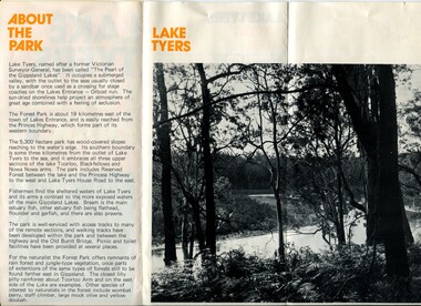
pamphlet, Lake Tyers Forest Park, 1960's
... Lake Tyers Forest Park...pamphlet lake tyers-forest-park...A three fold glossy, pamphlet titled"Lake Tyers Forest Park... lake tyers-forest-park A three fold glossy, pamphlet titled ...This pamphlet would have been produced as a tourist guide to East Gippsland.This item is a useful reference tool.A three fold glossy, pamphlet titled"Lake Tyers Forest Park". It contains information, a map and black / white photographs of Lake Tyers Park. Print colours are brown, white, yellow and black.pamphlet lake tyers-forest-park -
 Bendigo Historical Society Inc.
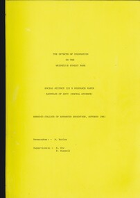
Book - THE EFFECTS OF RECREATION ON THE WHIPSTICK FOREST PARK, 1983
... THE EFFECTS OF RECREATION ON THE WHIPSTICK FOREST PARK....The Effects of Recreation on the Whipstick Forest Park... Bendigo whipstick Whipstick Forest Land Conservation Flora & Fauna ...The Effects of Recreation on the Whipstick Forest Park a Social Science III B research paper Bachelor of Arts (Social Science) Bendigo College of Advanced Education. 51 pages with maps.Anne Butlerbook, bendigo, whipstick, whipstick forest, land conservation, flora & fauna. -
 Bendigo Historical Society Inc.
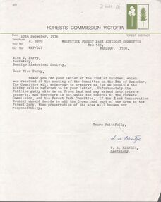
Document - JUNE PARRY COLLECTION: MINING IN BENDIGO - LETTER TO MISS J. PARRY
... Whipstick Forest Park Advisory Committee... to the Forest Park, then preservation of the area will become our... to Miss J Parry Forests Commission Victoria Whipstick Forest Park ...Typed letter from W. M. Flentje to Miss J. Parry, Secretary, Bendigo Historical Society referring to the preservation of land to preserve mining relics. Part of the land may extend into private property and some crown Land. He says, 'If the Land Conservation Council should decide to add the Crown land part of the area to the Forest Park, then preservation of the area will become our responsibility.' Letter written Forests Commission Victoria letterhead. It has a green logo on the top of two trees, one eucalypt type and the other, a pine. Letter dated 10th December 1976.document, memo, mining in bendigo, mining in bendigo, letter to miss j parry, forests commission victoria, whipstick forest park advisory committee, w m flentje -
 Orbost & District Historical Society
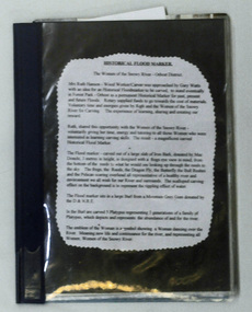
folder, Historical Flood Marker, 1999 - 2001
... of the flood marker in Forest Park, Orbost. It depicts the six highest... and photographs about the Historic Flood Marker in Forest Park, Orbost... of the flood marker in Forest Park, Orbost. It depicts the six highest ...This folder contains a record of the construction of the flood marker in Forest Park, Orbost. It depicts the six highest floods since the first recording. The construction of the marker was commenced in August 1999 and took eighteen months to be completed by nine volunteers under the tutelage of Ruth Hansen.This item is a contemporary record of the construction of an iconic marker in Orbost.A loose leaf folder containing information, records and photographs about the Historic Flood Marker in Forest Park, Orbost. Most photographs and printed text are glued in. There are twelve loose photographs.The front cover and spine are dark blue, the back is a lighter blue and has a bar code and price sticker attached.flood-marker-orbost -
 Bendigo Historical Society Inc.
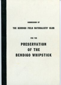
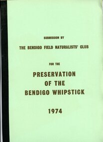
Document - PETER ELLIS COLLECTION: SUBMISSION BY THE BENDIGO FIELD NATURALIST CLUB FOR THE PRESERVATION OF THE WHIPSTICK 1971, 1971
... Nerring and Whirakee, Edgerton declared as Forest Parks under... as Forest Parks under the Appropriate Act.' The Submission has ...PETER ELLIS COLLECTION: Submission by The Bendigo Field Naturalist Club for the Preservation of the Whipstick Bendigo 1971 The submission was sent to the Minister for Forests. 'On behalf of the Bendigo Field Naturalist's Club, we, the President and Honorary Secretary, make application to the Forests Commission to have two areas, as approximately shown in green on the maps submitted (under separate cover), and being in the parishes of Huntly Nerring and Whirakee, Edgerton declared as Forest Parks under the Appropriate Act.' The Submission has the following contents: Bendigo's Claim for a Forest Park or National Park The Proposed Foiorest Parks Near Bendigo The Flora of The Proposed Whipstick Forest Park Species of Native Plants Bendigo Whipstick Area 1971 Species of Birds Bendigo Whipstick Area 1971 Mammals of the Whipstick Historical Bendigo Whipstick Statisticsperson, individual, peter ellis oam -
 Stawell Historical Society Inc
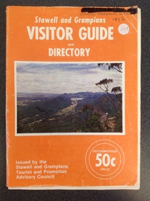
Book, Forests Commission, Stawell & Grampians Visitor Guide & Directory 1976, 1976
... is a Map Titled Grampain's Wonderland Forest Park.... Included is a Map Titled Grampain's Wonderland Forest Park stawell ...Tourist Brochure for Stawell and Grampians Region. Included is a Map Titled Grampain's Wonderland Forest ParkOrange Paper cover with white Print Middle of cover is a colour Picture of the Grampians.Stawell and Grampians VISITOR GUIDE and Directory. On teh Bottom right. Issued by the Stawell and Grampians Tourist Promotion Advisory Council . On the Left in two White circles "Recommended 50c Price."stawell tourism -
 Otway Districts Historical Society
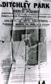
Photograph, Knox Collection, Sale of the Ditchley Park Estate, Beech Forest, 1908
... Sale of the Ditchley Park Estate, Beech Forest....beech forest; ditchley park; land sale; advertisment;... of the Ditchley Park Estate, Beech Forest. Under instructions from Mr. J.W... buyers for the Ditchley subdivision. beech forest; ditchley park ...Commercial realities and bushfires caused the Beech Forest community to re-establish itself around the railway station, away from Gardner Hill. This caused John W. Gardner to subdivide his land on the north side of the railway station. One subdivision was created near the Ditchley railway station on the old racecourse site, and another of 25 allotments forming what became Southorn Street. There were very few takers for these lots nor any buyers for the Ditchley subdivision.Photocopy. 260mm x 159mm. An advertisement for the sale of the Ditchley Park Estate, Beech Forest. Under instructions from Mr. J.W. Gardner Dalgety & Co. Ltd. will sell the subdivision of the Ditchley Park Estate on Tuesday, March 30, 1909, at 2 o'clock. A map of Beech Forest township and the Ditchley Park Estate is attached, as are the terms of sale and a description of the area.. beech forest; ditchley park; land sale; advertisment; -
 Eltham District Historical Society Inc
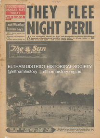
Newspaper - Newspaper articles, Sun News-Pictorial, They Flee Night Peril, The Sun News-Pictorial, Wednesday, January 17, p1, 1962
... Sherbrooke Park Forest... Ballarat Sherbrooke Park Forest Forest Commission Headquarters ...Various news articles pertaining to the January 1962 Victorian bushfires in the Dandenong and Healesville districts which by the third day had encompassed large areas of the State. Specific Eltham Shire districts mentioned include Panton Hill and Hurstbridge on page 1, Warrandyte on page 2, 3, 4 and 5, Hurstbridge, Smith’s Gully, Kinglake on page 3 and 4, Strathewen, Kangaroo Ground, Panton Hill, St. Andrews, Smith’s Gully on page 4 and Pound Bend, Smith’s Gully and Warrandyte on pages 20-21 • They Flee Night Peril, p1 (Illust.) • Their grim picnic; A flash fire strikes, p2 (Illust.) • Night of terror as towns quitted, p3 • Fought till he dropped, p3 (Illust.) • Rain in fire area, p3 • Wye River town goes, p3 • Black Friday Hero Dies In Fire; with wife, grandsons, p4 • Surrounded!, p4 (Illust.) • Main street houses ablaze, p4 • Hurstbridge is evacuated, p4 • Scores jump in river at Warrandyte, p5 • Hills people leave homes, p5 • “Fire” cry at Parlt., p5 • Blind – he’s safe now, p5 (Illust.) • Police Chief Runs Battle, p7 • From Fire Front: Hospital treats 34, p7 • Firms send help, p7 • Tragedy and Ruin: Third Day; Ferntree Gully; Warrandyte; Pound Bend; Smiths Gully; Escape for 18, pp20-21 (Illust.) • Church was a haven for the hurt, weary, p39 (Illust.) • A home is lost, p40 (Illust.) tom fielding collection, victorian bushfires - 1962, victorian bushfires – 1962, panton hill, hurstbridge, five ways crossroads, warrandyte south, dandenongs, upwey, mt. evelyn, monbulk, olinda, sassafras, st. andrews, warrandyte, christmas hills, yarra river, mitcham, whitehorse roiad, donvale, park orchards, metropolitan fire chief, w.t. aldridge, loughnan’s hill, ringwood, woori yallock, leslie ockwell, linda ockwell, kalorama, healesville, daylesford, fire damage – buildings, wye river, portland, eganstown, ballarat, sherbrooke park forest, forest commission headquarters, kallista, r.t. seaton, montrose, yallourn, central gippsland, smith’s creek, black friday, geoffrey ockwell, ronald ockwell, preston town hall, e.j. tenner, strathewen, kangaroo ground, eric farnsworth, adele farnsworth, robin farnsworth, roy cleland, ann cleland, belgrave, sassfras, kaloramalice commissioner porter, mansfield, box hill hospital, pound bend, ferntree gully, ferntree gully state school, w. carew, ann quinton -
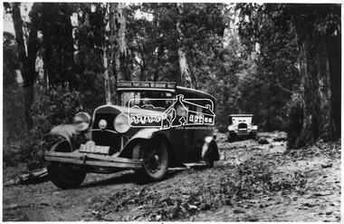 Eltham District Historical Society Inc
Photograph, Goodwood Powelltown Melbourne Daily
... automobile chrysler kinglake national park Forest track Digital image ...Two cars, probably 1929 Chryslers navigate the forest track probably Kinglake National Park. Front vehicle has sign: "Goodwood Powelltown Melbourne daily". Photo sourced from the Forests Commission of Victoria. Ref. JJ 399This photo forms part of a collection of photographs gathered by the Shire of Eltham for their centenary project book,"Pioneers and Painters: 100 years of the Shire of Eltham" by Alan Marshall (1971). The collection of over 500 images is held in partnership between Eltham District Historical Society and Yarra Plenty Regional Library (Eltham Library) and is now formally known as the 'The Shire of Eltham Pioneers Photograph Collection.' It is significant in being the first community sourced collection representing the places and people of the Shire's first one hundred years.Digital imagesepp, shire of eltham pioneers photograph collection, kinglake, goodwood powelltown melbourne daily, automobile, chrysler, kinglake national park, forest track -
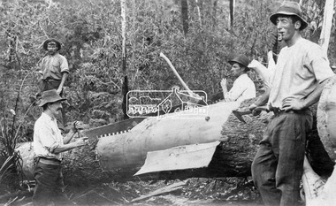 Eltham District Historical Society Inc
Photograph, Cutting timber for Browns Mill, Kinglake District
... mill Kingake national park forest bush Digital image Cutting ...Loggers from Brown's Mill, Kinglake use a hand saw to remove bark and split a tree trunk after its felling in the Kinglake forest. Circa 1923.This photo forms part of a collection of photographs gathered by the Shire of Eltham for their centenary project book, "Pioneers and Painters: 100 years of the Shire of Eltham" by Alan Marshall (1971). The collection of over 500 images is held in partnership between Eltham District Historical Society and Yarra Plenty Regional Library (Eltham Library) and is now formally known as 'The Shire of Eltham Pioneers Photograph Collection.' It is significant in being the first community sourced collection representing the places and people of the Shire's first one hundred years.Digital imagesepp, shire of eltham pioneers photograph collection, kinglake, browns mill, logging, loggers, lumber trade, brown's mill, kingake national park, forest, bush -
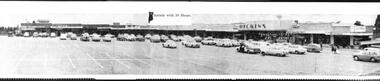 Whitehorse Historical Society Inc.
Photograph, Brentford Square, C.1963
... 25/9/1963. Brentford Square Shopping Centre Forest Hill car ...Cross Reference: ND996 Advertiser: Vol 10 No.45 25/9/1963.Black and white long thin photo of Brentford Square car park, 1963, showing shops such as Dickens & Foodland Supermarkets, which are no longer there.brentford square shopping centre forest hill, car park -
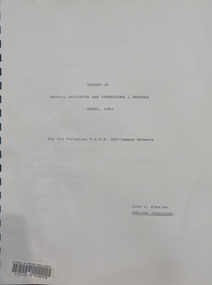 Federation University Historical Collection
Booklet, Report of Natural Resources and Operations 1 Seminar April, 1983, 1983
... to the You Yangs Forest Park, the Serendip Wildlife Research Station... Forest Park, the Serendip Wildlife Research Station and Werribee ...This report details the program of a Natural Resources and Operations Seminar for the Victorian T.A.F.E. Off-Campus Network, hosted by the Victorian School of Forestry in Creswick. Thirty-one participants were in attendance. The program was conducted from the 6th to the 8th of April, 1983 and excursions were made to the You Yangs Forest Park, the Serendip Wildlife Research Station and Werribee Gorge National Park.A ring bound booklet of 19 pages and clear laminate covers. Includes a map of the Victorian School of Forestry, Creswick.natural resources, seminar, school of mines ballarat, ballarat school of mines, victorian t.a.f.e off-campus network, school of forestry, creswick, victorian school of forestry -
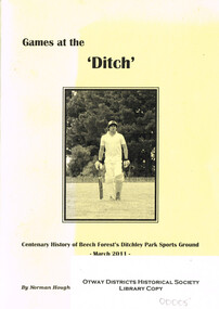 Otway Districts Historical Society
Book, Norman Houghton, Games at the "Ditch"
... Games at the "Ditch": centenary history of Beech Forest's... Forest great-ocean-road Design: Kelly McKiernan Printer ...Games at the "Ditch": centenary history of Beech Forest's Ditchley Park sports ground. Norman Houghton. Soft cover. ii, 31p., illus. March 2011. Publisher: Norman Houghton. Design: Kelly McKiernan Printer: Officeworks -
 Orbost & District Historical Society
box of documents, 1980s - 1990s
... Visitor Information Centre is situated in Forest Park on Nicholson... Visitor Information Centre is situated in Forest Park on Nicholson ...These documents were used at the Slab Hut (Orbost Information Centre) from 1985 - 1992 to record l visitor numbers, employment, activities, events and incorporation details. The Orbost Visitor Information Centre is situated in Forest Park on Nicholson Street. The centre is housed in the historic Slab Hut. The hut was an original family dwelling built in 1872, on a site approximately three kilometres upstream from the junction of the Buchan and Snowy Rivers.These documents record the history of tourism in the Orbost district.A cardboard storage box of documents and records of the Orbost & District Tourist Association / Slab Hut. It includes minute books, visitor numbers, details of volunteers, correspondence and details of activitiess and events.tourism-orbost slab-hut-orbost -
 Bendigo Historical Society Inc.
Map - CAMPBELL COLLECTION: BENDIGO AND DISTRICT MAPS
... Map. Bendigo Whipstick Forest Park, 1:75,000, reserved... Bendigo country lands Map. Bendigo Whipstick Forest Park, 1:75,000 ...Map. Bendigo Whipstick Forest Park, 1:75,000, reserved forest and crown land, highway main road access forest tracks. New Moon Mine, Elliot Dam, Nuggety Dam, Rogers Tree, Old Tom Mine, Blow Holes, Skylark Dam, Monument Rock, Hartland Eucalyptus Still and Dam, Hartland Eucalyptus Farm, Millwood Dam, Sandner Eucalyptus Still Site, Various unmarked dams. (number 391 in map cupboard 1)map, bendigo, country lands -
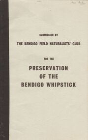 Bendigo Historical Society Inc.
Book - 'PRESERVATION OF THE BENDIGO WHIPSTICK'' (SUBMISSION)
... Forest Parks under the Appropriate Act. (The two areas... to the Forests Commission for two areas to be declared Forest Parks under ...Preservation of the Bendigo Whipstick'' (Third Edition of a Submission by the Bendigo Field Naturalists' Club 1971). An application to the Forests Commission for two areas to be declared Forest Parks under the Appropriate Act. (The two areas are indicated on a map submitted under separate cover). Supportive material includes listings of various categories e.g. flora i.e Whipstick native plants; Additional Plant Species; Species of Birds; Mammals of the Whipstick; historical summary; Whipstick nuggets; Bendigo Whipstick 'Statistics'. .Bendigo Field Naturalist Club.government, state, whipstick, bendigo whipstick, the bendigo field naturalists club. shire of lodden map. -
 Orbost & District Historical Society
albums, late 1980's
... in Forest Park on Nicholson Street. The centre is housed... is situated in Forest Park on Nicholson Street. The centre is housed ...These two albums were used at the Slab Hut - Orbost Visitor Information Centre. The Orbost Visitor Information Centre is situated in Forest Park on Nicholson Street. The centre is housed in the historic Slab Hut. The hut was an original family dwelling built in 1872, on a site approximately three kilometres upstream from the junction of the Buchan and Snowy Rivers. No nails were used in the construction; it was all wired together. After a period in storage the slab hut was opened in its present location in Orbost as the Information Centre in 1987.These albums are contemporary records of the construction and relocation of an iconic Orbost building, the Slab Hut.Two large photo albums. 2280.1 has no front cover. The back cover and spine are red. The pages are black and most photos are labelled. They are photographs of the Orbost area. 2280.2 has brown covers. It contains photographs of the construction of the gardens and buildings around the Slab Hut (Orbost Visitor Information Centre). On the cover in gold print is "PHOTOS".slab-hut-orbost album-photographs-orbost -
 Orbost & District Historical Society
black and white photographs, 1980s? (winter months)
... . Bank in the middle distance and Hoffman's paddock (Forest Park.... Bank in the middle distance and Hoffman's paddock (Forest Park ...All photographs seem to have been takenfrom the Telecom tower on the corner of Browning and Wolseley Streets in Orbost 3259.1 is a view of the Orbost township looking north-east. The swimming pool and bowling club can be seen in the foreground. 3259.2 is aview looking north-west and showing the tennis courts and clubhouse, the Recreation Reserve oval, the Youth Centre, Historical Museum, Municipal Offices, Senior Citizens clubrooms with the fire station in the foreground. 3259.3 is a view looking south with the Shire of Orbost Municipal offices and Ruskin Street in the foreground. Munro Street can be seen running from Ruskin Street to St Joseph's School in the middle distance. Lochiel Park oval, Lochiel House, the Snowy River and highway bridge are in the background. 3259.4 is a view looking south showing the Club Hotel, C.B.C. Bank in the middle distance and Hoffman's paddock (Forest Park) and the Snowy River beyond. 3259.5 is a view looking north-east over houses. 3259.6 is aview over the main street, Nicholson Street.showing the main shopping precinct. Shop signs for Permewans, Williams Shoes, F.B. Dicken and Orbost Bakery can be seen. 3259.7 is a view looking south west and shows Forest park and beyond towards Bete Bolong.These photographs are detailed pictorial records of the township of Orbost.Seven black / white photographs taken from above a township. Chimney smoke can be seen in the photographs.orbost-township-1980s aerial-photograph-orbost -
 Orbost & District Historical Society
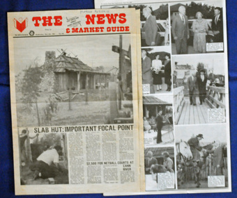
newspaper clippings, April, May 1987
... is situated in Forest Park on Nicholson Street. The centre is housed... Centre is situated in Forest Park on Nicholson Street. The centre ...The Slab Hut (Orbost Visitor Information Centre) was opened on March 28, 1987. It was officially opened by Dr D. Caughey, the governor of Victoria. The Orbost Visitor Information Centre is situated in Forest Park on Nicholson Street. The centre is housed in the historic Slab Hut. The hut was an original family dwelling built in 1872, on a site approximately three kilometres upstream from the junction of the Buchan and Snowy Rivers. The Hut was removed from its original site around 1970, and stored until 1984 when the Shire Council approved the current site. It was restored and brought to life as a Tourist Information Centre in 1987.The Slab Hut is an icon of Orbost. These newspaper articles are contemporary records of the opening of this building.A selection of articles from The News and the Snowy River Mail. All relate to the opening of the Slab Hut, the Orbost Visitor Information Centre. They are photographs, information and the history of the Slab Hut.slab-hut-orbost newspaper-snowy-river-mail -
 Ballan Shire Historical Society
Map - Map. Shire of Ballan, Shire of Ballan
... roads, rivers, towns, settlements, State parks and forests..., towns, settlements, State parks and forests and land ...This is a fairly comprehensive map of the former Shire of Ballan which is now amalgamated into the Shire of Moorabool.A black and white map of the Shire of Ballan showing major roads, rivers, towns, settlements, State parks and forests and land subdivisions. It appears to be a copy of the original as no dates or maker or printer appear on the map. There is a scale of 2 miles to 1 inch.gordon, ballan, bungal, kerrit bareet, borhoneyghurk, bungeeltap, ballark, yaloak, gorong, beremboke, wallace, ingliston, hunterston, millbrook, bradshaw, myrniong, blackwood, moorarbool, greendale, bayup, trentham, bullarto, korweinguboora, glenlyon, bolwarra -
 Bendigo Historical Society Inc.
Document - PETER ELLIS COLLECTION: SUBMISSION BY THE BENDIGO FIELD NATURALIST CLUB FOR THE PRESERVATION OF THE WHIPSTICK 1974, 1974
... to the Whipstick scrub) declared Forest Park. It is the central belt... to the Whipstick scrub) declared Forest Park. It is the central belt ...PETER ELLIS COLLECTION: SUBMISSION BY THE BENDIGO FIELD NATURALIST CLUB FOR THE PRESERVATION OF THE WHIPSTICK 1974 The submission was sent to: the Minister for Local Government and the Town and Country Planning Board The Minisry for Conservation and its agency, the Forests Commission and Lands Department Federal Government Ministeries for Environment, Concervastion and Science, and the National Estate. Opening Paragraphs: This re-submission was compiled to bring to the attention of the authorities many aspects relating to the preservation of the Bendigo Whipstick which were not so apparent at the time of the earlier submission. In fact the 19721 submissions was mainly aimed at having reserved forest (which lie a opposite extremities to the Whipstick scrub) declared Forest Park. It is the central belt of Whipstick scrub that is of scientific interest and considered unipue and which we were primarily concerned in preserving and retaining as one viable ecological unit. The Submission consists of: INTRODUCTION Opening Explanation Whipstick Eucalyptus Cutting for Oil Distallation (Photographs) Agricultural Intrusions into the Whipstick (Photographs) CONTENTS Illustrations The Significance of the Bendigo Whipstick Diary of Whipstick Conservation Events Socialogical Implications Conservation policies and reccomendations Agricultural Aspects Eucalyptus Oil Situation Alternatives for the Eucalyptus Oil Industry Future Conservation of the Whipstick Reccomendation for Acquisition Programperson, individual, peter ellis oam -
 The Beechworth Burke Museum
Photograph, c1885
... grazing properties in the Ovens area. He had the Forest Park... had the Forest Park Hotel at Carboor, the Creamery at Carboor ...This carte de visite was taken of Hiram Crawford in fire brigade uniform taken by Stewart & CO., Melbourne. Hiram Crawford was Captain of the Beechworth Volunteer Fire Brigade for twenty-five years. Hiram arrived in Australia at the age of 21 in August 1853. He mined for short time at Back Creek Bendigo, then went to the Ovens where he sought gold in Spring Creek, Buckland and 3 Mile. After moving to Albury for 18 months he married Anna, moved to Woolshed and was there for two years mining gold. After discovering his fortune he formed Crawford and Co. Coaching Lines in Beechworth in late 1856. It was this company which became the longest surviving coaching business in the State of Victoria. Hiram and Anna had two daughters. Anna died in March 1862 and in May Hiram left from Melbourne to return to the United States on a visit. Hiram married Martha Foster during this visit and returned to Australia in March 1863. With his coach line established, and leaving it under management, he moved around the north east of Victoria establishing and building shops and the Star Hotel and Theatre in Chiltern in 1866. In 1869 he moved to Melbourne for a few years in which time he built the Eastern Arcade in Bourke Street. In 1876 the family returned to Beechworth for a few years eventually moving to Everton where Hiram grew hops, tobacco, fruit trees and established the largest lemon orchard at that time in Australia. Hiram spent a considerable amount of his time helping to develop the North East of the State not only in his private endeavours but as a public figure. Among his many achievements a few are listed - Councillor, Mayor of Chiltern and Beechworth, President of the Shire on two occasions, Director of many mining companies, Inaugural Chairman and Director of the Beechworth Gas Company roles he held for over 20 years, Foundation member of Beechworth Pottery, Committee member of the Beechworth Hospital, Captain/Superintendent of the Vol. Fire Brigade for over 20 years, Foundation, Life member of and on the State Fire Brigade Board for many years, President of the North Eastern Railway League in Chiltern On a personal level Hiram was involved in lodges including St. Johns #14, Beechworth. and had several grazing properties in the Ovens area. He had the Forest Park Hotel at Carboor, the Creamery at Carboor, and grazing land on which the Milawa Creamery was built during his ownership. He was a committee member for 3 committees duirng the 1888 International Exhibition in Melbourne. Hiram had many voyages around the world studying irrigation, hop growing, tobacco growing and drying. During his retirement in Melbourne Hiram purchased many properties in the Elsternwick area and acted as an Estate Agent. After the death of his second wife Martha, Hiram married for the third time in 1912 to Sophia Maude Heatley. Crawford and Co continued until 1921. [Taken from HighCountryHeritage.com.au]Black and white reproduction of a studio portrait of Hiram Crawford in fire brigade uniform, printed on gloss photographic paper and bordered with a white frame.Badge on uniform sleeve reads: CAPTAIN / BVFB Obverse: AB/ Stewart & CO./ Melbourne Reverse: Hiram Collection/ BMM2435burke museum, emergency services, beechworth, carte de visite, black and white, fire brigade, hiram crawford, stewart & co., melbourne. -
 Orbost & District Historical Society
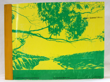
book, Report on the East Gippsland Study Area, June 1974
... , such as Parks, State Forest, and so on. " The Council met on seven..., such as Parks, State Forest, and so on. " The Council met on seven ...In 1961 Bruce Evans was elected to the Victorian Legislative Assembly as the member for Gippsland East. He was the party's deputy leader from 1964 to 1970 and its whip from 1970 until his retirement in 1992. "The Land Conservation Council was established by the Land Conservation Act 1970. As one of its three functions, it makes recommendations to the Minister for Planning and Environment with respect to the use of public land, in order to provide for the balanced use of land in Victoria. This report contains the Council’s final recommendations concerning the use of public land in the East Gippsland study area, the boundaries of which correspond to those of the Shire of Orbost. The recommendations in the text are grouped under major headings, such as Parks, State Forest, and so on. " The Council met on seven occasions during the year, and also made visits of inspection to each study area. The Chairman visited Shire Councils in study areas to explain the role and the functions of the Land Conservation Council and to invite submissions on the use of public land in these areas. This is the fourth annual report by the council. This is a useful research tool.A large book 236 pp book with a yellow / gold cover with a green bush scene . The binding is orange. It contains folded maps and information on public land use in East Gippsland.inside - "With Compliments - Bruce Evans, M.P."east-gippsland-study-area conservation public-land-use -
 Falls Creek Historical Society
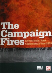
Book - The Campaign Fires - North-East/East Gippsland Fires 2003, Lyndel Hunter
... and forests, including 60 per cent of the Alpine National Park and 81... and forests, including 60 per cent of the Alpine National Park and 81 ...A description of efforts to fight the bushfires in Gippsland in 2003, including maps and illustrations. This volume was published as a tribute to the work of staff and volunteers who put themselves at risk to protect local communities. It shows the impact on those communities in Victoria and the support they gave to those involved in fighting largest bushfires in Victoria for 60 years. The Alpine bushfires started on 8th January 2003, a day of Total Fire Ban. Lightning ignited 87 fires in the North-East and East Gippsland regions. Eight of these fires were unable to be contained; they joined together to form the largest fire in Victoria since the Black Friday fires in 1939. The majority of the area burnt in Victoria was public land, 1.19 million hectares of parks and forests, including 60 per cent of the Alpine National Park and 81 per cent of the Mt Buffalo National Park. Firefighting efforts were made difficult in hard-to-access, remote forest terrain. Approximately 90,000 hectares of private land was burnt.This book is significant because it documents the 2003 Victorian Bushfires and serves as a tribute to the CFA staff and volunteers who fought them.This publication of 119 pages features text, colour images, maps and detailed information related to the 2003 bushfires in Victoria.At bottom of front cover:- CFA Victoria Logo Victorian Government Logovictorian fires 2003, cfa (vic) -
 The Beechworth Burke Museum
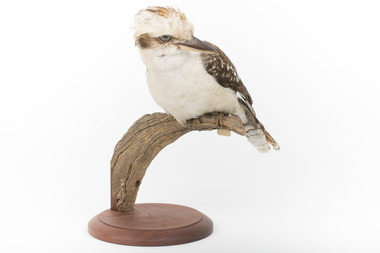
Animal specimen - Kookaburra, Trustees of the Australian Museum, 1860-1880
The Kookaburra is a sociable bird commonly seen in small flocks. These flocks mainly consist of family members. If not in flocks, these birds are commonly seen in pairs. They have a distinct appearance with brown wings, back and brown around the eyes, with majority of the plumage being white. This species reside in woodlands and open forests, however they can be seen in parks, wetlands, farms and any other space that is open with grass. This native Australian bird can mainly be found across the eastern Australia, however they have been introduced Tasmania, South-west Western Australia and New Zealand. Although this is a taxidermy mount, it looks exactly like a Kookaburra in real life. This specimen is part of a collection of almost 200 animal specimens that were originally acquired as skins from various institutions across Australia, including the Australian Museum in Sydney and the National Museum of Victoria (known as Museums Victoria since 1983), as well as individuals such as amateur anthropologist Reynell Eveleigh Johns between 1860-1880. These skins were then mounted by members of the Burke Museum Committee and put-on display in the formal space of the Museum’s original exhibition hall where they continue to be on display. This display of taxidermy mounts initially served to instruct visitors to the Burke Museum of the natural world around them, today it serves as an insight into the collecting habits of the 19th century.This specimen is part of a significant and rare taxidermy mount collection in the Burke Museum. This collection is scientifically and culturally important for reminding us of how science continues to shape our understanding of the modern world. They demonstrate a capacity to hold evidence of how Australia’s fauna history existed in the past and are potentially important for future environmental research. This collection continues to be on display in the Museum and has become a key part to interpreting the collecting habits of the 19th century.This Kookaburra has a predominantly white body. The back, wings and tail are a light shade of brown. There is a strip of brown going across the eyes. This specimen stands upon a wooden branch and has an identification tag ties around its leg. This bird is stout in shape and has a medium length tail and a broad bill. This bill is darker on top and lighter in colour on the bottom.W8083 / taxidermy mount, taxidermy, animalia, burke museum, beechworth, australian museum, skin, reynell eveleigh johns, bird, kookaburra, australian birds, laughing kookaburra -
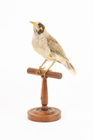 The Beechworth Burke Museum
Animal specimen - Noisy Miner, Trustees of the Australian Museum, 1860-1880
Noisy Miners are native to Australia and can be found on the East Coast. Noisy Miners live in northern Queensland and all along the eastern coast to South Australia and Tasmania. Noisy Miners are found in woodlands and open forests. They have also become well adapted to suburban situations and are a common sight in parks and gardens. The Noisy Miner feeds on nectar, fruits and insects. Very occasionally they will eat small reptiles and amphibians. Food is either taken from trees or on the ground. In keeping with its highly social nature, the Noisy Miner usually feeds in large groups. The Noisy miner specimen is mounted accurately. This specimen is part of a collection of almost 200 animal specimens that were originally acquired as skins from various institutions across Australia, including the Australian Museum in Sydney and the National Museum of Victoria (known as Museums Victoria since 1983), as well as individuals such as amateur anthropologist Reynell Eveleigh Johns between 1860-1880. These skins were then mounted by members of the Burke Museum Committee and put-on display in the formal space of the Museum’s original exhibition hall where they continue to be on display. This display of taxidermy mounts initially served to instruct visitors to the Burke Museum of the natural world around them, today it serves as an insight into the collecting habits of the 19th century.This specimen is part of a significant and rare taxidermy mount collection in the Burke Museum. This collection is scientifically and culturally important for reminding us of how science continues to shape our understanding of the modern world. They demonstrate a capacity to hold evidence of how Australia’s fauna history existed in the past and are potentially important for future environmental research. This collection continues to be on display in the Museum and has become a key part to interpreting the collecting habits of the 19th century.The Noisy Miner is identified by its mostly grey body and black crown and cheeks. The bill is yellow, as are the legs and the naked skin behind the eye. The name is well suited as the common calls are uttered repeatedly by the members of the colony .Despite their moderate size, Noisy Miners aggressively attack larger birds such as hawks and kookaburras. These attacks may be so vigorous that most other birds are excluded from an area occupied by Noisy Miners.Swing tag: 65a. Garrulous Honey-Eater / See Catalogue, page 19 /taxidermy mount, taxidermy, animalia, burke museum, beechworth, australian museum, skin, reynell eveleigh johns, bird, australian birds, noisy miner, garrulous honeyeater, yellow beak, honeyeater, east coast -
 The Beechworth Burke Museum
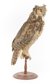
Animal specimen - Long-Eared Owl, Trustees of the Australian Museum, 1860- 1880
The Long-eared owl is one of the most widely distributed and most numerous owl species in the world. It is a rather slim and long-winged bird with usually prominent erectile ear tufts, which are positioned closer to the center of the head than in many other types of owl. Long-eared owls prefer open landscapes with groups of trees, hedges or small woods, as well as pastureland with rows of trees and bushes, any type of forest with clearings, forest edges, semi-open taiga forest, swampy areas and bogs, orchards with old fruit trees, parks, even gardens and timbered areas in villages, towns or cities. In many parts of the world, Long-eared owls have even adapted to deserts, though more commonly semi-desert, and may nest and roost in available oases and hunt prey over the open desert ground. This particular specimen has been mounted in a correctly stylised fashion. This specimen is part of a collection of almost 200 animal specimens that were originally acquired as skins from various institutions across Australia, including the Australian Museum in Sydney and the National Museum of Victoria (known as Museums Victoria since 1983), as well as individuals such as amateur anthropologist Reynell Eveleigh Johns between 1860-1880. These skins were then mounted by members of the Burke Museum Committee and put-on display in the formal space of the Museum’s original exhibition hall where they continue to be on display. This display of taxidermy mounts initially served to instruct visitors to the Burke Museum of the natural world around them, today it serves as an insight into the collecting habits of the 19th century.This specimen is part of a significant and rare taxidermy mount collection in the Burke Museum. This collection is scientifically and culturally important for reminding us of how science continues to shape our understanding of the modern world. They demonstrate a capacity to hold evidence of how Australia’s fauna history existed in the past and are potentially important for future environmental research. This collection continues to be on display in the Museum and has become a key part to interpreting the collecting habits of the 19th century.This Long-Eared Owl is a rather slim, long-winged bird with prominent erectile ear tufts. The coloration of this Long-eared Owl is a hue of ochraceous-tawny with a brownish wash. The wings, back and chest are patterned and the facial disc is visibly well developed and light brown in colour. The ear tufts are dusky in front and darter tawny on the back. This Long-eared owl possesses a light-coloured bill and its eyes are yellowish-orange. The specimen stands upon a wooden platform. Swing tag: 33 / Virginian / Bee-boo Owl / Catalogue, page 52 / Other tag: No 19 / STRIX Virginian / N. America / taxidermy mount, taxidermy, animalia, burke museum, beechworth, australian museum, skin, reynell eveleigh johns, bird, owl, long-eared owl -
 Orbost & District Historical Society
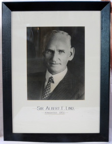
framed photo, APFA- Davisigns (PG & ME Davis)
This photo was inherited with the building when the museum was established. Lind was born in 1878 in East Charlton, Victoria, the son of Oliver Nicholas Lind, a farmer from Denmark, and his Welsh wife Mary Ann Clay. In 1882, drought forced the family to move to East Gippsland where Lind was educated at Lucknow, and then to Bairnsdale in 1884 where he attended Bairnsdale state school. In October 1920, he was elected to the Victorian Legislative Assembly for the seat of Gippsland East for the Victorian Farmers' Union. Lind was made Minister of Forests, President of the Board of Land and Works and Commissioner of Crown Lands and Survey in Albert Dunstan's cabinet. He was knighted in 1951. In 1926 two national parks east of Orbost were named the Albert and the Lind national parks after him.A framed photo of Sir Albert Eli Lind. It is a black and white head and shoulders photo in a black wooden frame.Sir Albert E. Lind Knighted !951photograph politician lind-albert government -
 The Beechworth Burke Museum
Photograph, 1944
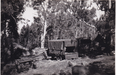
Taken in 1944, the photograph depicts two trucks and a trailer park at an undisclosed location inside the Stanley forest. An unidentified young man is standing in the background. There are also two tents installed on either side of the vehicles. A secret experimental micro-wave radio station was established and tested in Stanley, Victoria by the Army Signal Detachment Unit during World War II. It was part of an experimental Ultra High Frequency (UHF) link between Melbourne and Sydney. At the time, it was highly classified. It intended to enquire into the hitherto unexplored transmission of micro-waves; that is, a radio signal which could only be transmitted by line of sight, and thus required hill-top to hill-top location.The photograph is historically significant as it pertains to World War II; the largest global conflict in history. This significance is enhanced by Australia's prominent involvement in campaigns across the Pacific, particularly on land in New Guinea and across the Huon Peninsula. It was also the first time that the Australian mainland came under direct attack by the Axis, with Japanese forces targeting north-west Australia and Sydney Harbour. These battles became Australia's largest and most complex offensives during the war. The record is also historically significant as it relates to the Royal Australian Corps of Signals, or "RA Sigs". This significance is strengthened by Australia's unique distinction of having the first established signal unit under the British Empire. This unit provides electronic warfare. They enable commanders to implement highly dynamic battle control against opposing forces by using a number of methods including radio, fibre optic, micro-wave, information systems and satellite links. The record has strong research potential. This is due to the ongoing scholarly and public interest in war, military history, the ANZAC legend, and the continuing existence of the RA Sigs. The historic context of this record can provide insight into Australia's history, military, technological innovation and advancements, as well as national economic, defence and foreign policies after 1945.Black and white rectangular photograph printed on matte photographic paper.Reverse: BMM5095.8 /military album, army album, wwii, world war ii, army signal detachment unit, royal australian corps of signals, ra sigs, stanley, army truck, victoria, beechworth, melbourne, sydney -
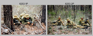 Bendigo Military Museum
Photograph - Army Survey Regiment - Regimental Training Field Phase, 1995
This is a set of twenty photographs of the Army Survey Regiment undertaking regimental training in state forest north of Costerfield, Victoria, 1995. The state forest is now part of the Heathcote-Graytown National Park. The aim of the training was to provide personnel practical revision of infantry and minor tactics at the section level, navigation and map reading, RATEL and Survival in the Field. This was the Army Survey Regiment’s last military skills field training exercise before disbandment of RA Svy and the weather on the last day was wet and cold. It provided soldiers who decided to continue their military service essential military skills revision and for those who chose to discharge from the Army, it reinforced their decision to leave. LTCOL Duncan Burns was the last CO of the Army Survey Regiment from 1994 to 1996 and WO1 Ken Johnston OAM MM from RA Inf was the RSM for one year in 1995.This is a set of twenty photographs of the Army Survey Regiment undertaking regimental training in state forest north of Costerfield, Victoria, 1995. The photographs were printed on photographic paper and are part of the Army Survey Regiment’s Collection. The photographs were scanned at 300 dpi. .1) - Photo, colour, 1995, unidentified personnel. .2) - Photo, colour, 1995, L to R: Derek Percival, Damien Cole, unidentified. .3) - Photo, colour, 1995, L to R: unidentified, Chris ‘Charlie’ Brown, unidentified (x2). .4) - Photo, colour, 1995, unidentified personnel. .5) - Photo, colour, 1995, unidentified. .6) - Photo, colour, 1995, unidentified personnel. .7) - Photo, colour, 1995, unidentified personnel. .8) - Photo, colour, 1995, L to R: Jim Ash, Syd Anstee, unidentified, Rob Bogumil. .9) & 10) - Photo, colour, 1995, L to R: Steve Hill OAM CSM, Rob Bogumil, Brian Paul, Jim Ash, Syd Anstee, Colin Davidson. .11) - Photo, colour, 1995, L to R: Paul ‘Hutch’ Hunter, Stu Ridge, Chris ‘Charlie’ Brown. .12) - Photo, colour, 1995, RSM WO1 Ken Johnston OAM MM. .13) - Photo, colour, 1995, Peter Imeson. .14) - Photo, colour, 1995, L to R: Stu Ridge, Alan Virtue. .15) - Photo, colour, 1995, CO LTCOL Duncan Burns. .16) - Photo, colour, 1995, unidentified personnel. .17) - Photo, colour, 1995, L to R: Tony Harder, CAPT Sutiman (Indonesian Exchange Officer), Kasey ‘Tiges’ Northausen, unidentified (x2), Mick Duggan. .18) - Photo, colour, 1995, CAPT Sutiman (Indonesian Exchange Officer). .19) & 20) - Photo, colour, 1995, unidentified personnel..1P to .20P – No personnel are identified.royal australian survey corps, rasvy, army survey regiment, army svy regt, fortuna, asr