Showing 115 items
matching forest industry
-
 Marysville & District Historical Society
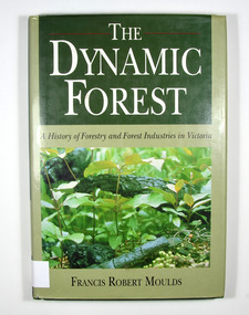
Book - Hardback book, The Dynamic Forest-A History of Forestry and Forest Industries in Victoria, 1991
... forest products industry...A history of forestry and forest industries in Victoria... of forestry and forest industries in Victoria forests forestry forest ...A history of forestry and forest industries in VictoriaHardback. Green dust cover with photograph of forest undergrowth. Front end paper shows a map of Victoria detailing forested and non-forested areas in the State of Victoria in the year 1869. Back end paper shows a map of Victoria detailing forested and non-forested areas in the State of Victoria in the year 1987. To Jean, who bore the/ brunt of it all - and to/ Jan, Rob, Sue and Andy Stamp of the Marysville & District Historical Society Inc / P.O. Box 22 / Marysville 3779forests, forestry, forest products industry, victoria, history, moulds, francis robert -
 Lakes Entrance Regional Historical Society (operating as Lakes Entrance History Centre & Museum)
Photograph, 1936 c
... Forest Industry... Entrance gippsland The T Model Ford cost him 28 pounds Forest ...The T Model Ford cost him 28 poundsBlack and white photograph of Charles Pettman and William Henry Flukes standing beside Charles T Model Ford on a forest track East Gippslandforest industry -
Lakes Entrance Regional Historical Society (operating as Lakes Entrance History Centre & Museum)
Photograph, 1912
... Forest Industry... train on bridge at Bruthen 1920 c 05091.1 9 x 12 cm Forest ...Also a black and white photograph of a goods train on bridge at Bruthen 1920 c 05091.1 9 x 12 cmSepia toned photograph of workmen with horses and drays working on railway cutting at Bruthen VictoriaRailway cutting at Bruthen 1912 - courtesy Mrs E Nealforest industry -
Lakes Entrance Regional Historical Society (operating as Lakes Entrance History Centre & Museum)
Photograph, 1993
... Forest Industry... with Police Forest Industry Transport Black and white photograph ...A large number of East Gippslanders joined protesters at Bairnsdale Railway Station on Saturday 25 August 1993 to stop the last train leaving for Melbourne The train finally left early Monday morning when protesters cooperated with PoliceBlack and white photograph showing protesters on railway line end of train on left group of school children with banners at Bairnsdale railway station to prevent last train leaving for Melbourne Bairnsdale Victoriaforest industry, transport -
Lakes Entrance Regional Historical Society (operating as Lakes Entrance History Centre & Museum)
Book, Joint Commonwalth Forests Steering Committee, East Gippsland Forest Agreement Consultation Paper 2000, 2000
... Environment Forest Wool Industry Prepared by the joint ...Prepared by the joint Commonweath and Victoria regional forest agreement steering committee Barton ACTenvironment, forest, wool industry -
Lakes Entrance Regional Historical Society (operating as Lakes Entrance History Centre & Museum)
Book, Harris Daishowa Australia Pty Ltd, Eden Woodchip Industry Short Report 1995, 1995
... Forest Management Timber Industry A short report detailing ...A short report detailing the history of the Eden NSW forests and the development of the wood chipping industryforest, management, timber industry -
Lakes Entrance Regional Historical Society (operating as Lakes Entrance History Centre & Museum)
Book, Forestry Commission of NSW, Wood chips from Eden 1990, 1975c
... Forest Paper Making Industry A promotion leaflet describing ...A promotion leaflet describing the background of the wood chip industry and justifying methods used by citing examples of the growth and development of the town of Eden New South Walesforest, paper making industry -
Lakes Entrance Regional Historical Society (operating as Lakes Entrance History Centre & Museum)
Book, Australian Paper, Maryvale Mill, 2000c
... Forest Paper Making Industry A promotional booklet ...A promotional booklet describing the paper production of Maryvale Mill Morwell Victoriaforest, paper making industry -
 Forests Commission Retired Personnel Association (FCRPA)
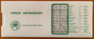
Forest Metriverter, Side Rule
... before metrication finally arrived in the forest and timber... before metrication finally arrived in the forest and timber ...Decimal currency was spectacularly introduced in an overnight overthrow on 14 February 1966, but it took another 8 years before metrication finally arrived in the forest and timber industry. Eventually, the measurement of logs and sawn timber changed from imperial, and excruciating, measures such as super feet of sawn timber, billets and cunits (100 cubic feet) of stacked pulpwood and hoppus log volumes to simpler cubic metres. Measuring firewood was a particular nightmare. For example, there were standard chords, stove cords, kitchen cords, running cords, face cords, thrown chords, fencing cords, country cords, long cords, raummeter or steres (1m x 1m x 1m). A standard cord of firewood had a volume of 128 cubic feet, measured as a pile 8 feet long, 4 feet high and 4 feet wide (3.624 m3). And how about this for confusing…. in Victoria, an imperial or long ton (by measure) of green firewood was a stack 5 feet long billets (2 axelengths at 2′ 6″ each), one axelength high (2′ 6″) and two axelengths long (5 feet) equalling 62.5 cubic feet. For added befuddlement, there were three different sorts of tons: Imperial tons or long tons, American short tons and metric tonnes (spelled with two n’s). Not forgetting that a cubic imperial ton of firewood (40 cubic feet) which equalled 1.133 cubic metre. The metrication process began in 1974 and was completed by 1976 but the transition was not without its challenges along the supply chain for foresters, overseers, logging contractors, sawmillers, hardware stores and builders alike. Timber lengths changed from feet to metres but were still sold in multiples of one foot or 0.3 m (1.8, 2.1, 2.4, 2.7 etc) whereas a menacing lump of 4-Bee-2 transformed into a rather less colourful 100mm by 50mm. Measurement and calculations of area also became so much easier in hectares rather than complicated acres, roods and perches. The Forest Metriverter slide-rule was issued by the Forestry and Timber Bureau to make metric conversions easier.Forest MetriverterRoss Pennyforest measurement, surveying, forests commission victoria (fcv) -
 Orbost & District Historical Society
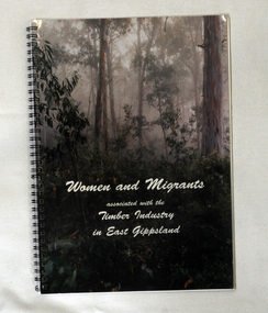
book, Quick Print, Women and Migrants Associated With The Timber Industry in East Gippsland, 2001
This book developed from a project undertaken by the Orbost Women's Awareness Group. It began as an activity in learning how to conduct "Oral Histories". With a substantial amount of information resulting the group decided to publish the information in the form of this book. Orbost Women's Awareness Group was originally the "Orbost Women's Pulp Mill Association" created in 1989 to disseminate information about a proposed pulp mill planned for the area. When the proposal became non viable the group continued to meet as an awareness group. It continues today as the Orbost Women's Awareness Group.This book is a research tool for those interested in the timber industry of East Gippsland.A spiral bound 44pp book with a photo of the forests of East Gippsland on the cover. The title is in cursive writing in white print. it contains the personal stories and b/w photographs of both women and migrants who have been associated with the timber industry in East Gippsland. timber-industry east-gippsland orbost-women's-awareness-group -
 Orbost & District Historical Society
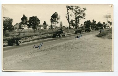
black and white photograph, mid 20th century
The photograph shows three trucks hauling logs of 120 feet, 116 feet and 118 feet long. Said to be the longest logs ever taken from East Gippsland forests, three special vehicles were needed to transport three giants, the longest measuring 120 feet, from the McKenzie River to Traralgon. Mr. J. De Piazza, of Orbost, was in charge of the transport of the logs. This photograph shows the logs passing through Bairnsdale.Orbost has historically been based on the timber industry, but that industry has declined considerably over the last 20 years. The number of locals involved in the timber industry has declined and many of the mills have closed. This item reflects a time when that industry was a significant contributor to the economy of the district.A black / white photograph of three trucks hauling logs of various lengths.on front - "120 ft; 118 ft; 116 ft" on back -" J. De Piazza, 23 Boundary Rd, Orbost, 1942"timber-industry-orbost -
 Orbost & District Historical Society
photograph album, James, Harry, 1900 - 1910
Photographs in this album are : forest,creek; Burns Cutting; river with bridge; Tony in his boat (spare print); Murrungowar and three of Conran.Henry James (1860-1932) was a well-known identity in the Orbost district.He was a stock agent and auctioneer who helped to establish the seed bean industry in Orbost. He was the second secretary of the Snowy River Shipping Co. as well as a shire councillor and prominent member of MUIOOF.a fabric covered book with gold print - "Photographs" on front cover. It contains an assortment of photographs.inside front cover - "Photographs taken by Mr Harry James about 1900-10"james-harry photography-orbost-conran-murrungowar -
 Kiewa Valley Historical Society
Postcard Circa 1950, Snow Plough, Bogong High Plain,5,500 Feet Kiewa Hydro-Electric Project, Circa 1950
This postcard was produced in the 1950's for the tourist trade in the Kiewa Valley and Alpine region. It encompasses the period when the State of Victoria was pressured by the ever increasing demand by industry and its population for electricity supplies. Hydro electricity was seen as an untapped natural resource to quench this demand. The Victorian Alps and the rivers flowing into its valleys was ideal for the construction of the Kiewa Hydro Electricity Scheme. The late 1940's saw the development of this scheme and the changing of sections of alpine landscape is covered by this and other postcards/pictures (tourists, construction workers, and established rural populations). This period in time was before the established wildlife and forest/nature groups became political activist who changed legislative acts to protect the environment. This rural region (Kiewa Valley/alpine plains) was at most only significant to a smaller group of winter sports, summer hikers/horse riders and rural farmers/graziers. The numbers of tourists and the increase in the local resident population was boosted by the construction of the Hydro Electricity Scheme. This influx to the regional population resulted in a corresponding diversity in services and brought about an environment that responded to a growing level of tourists and thereby permitting this industry to grow more rapidly than it would have naturally. This postcard details an attraction to the "cleaner" method of providing electricity. This postcard was purchased in 1950 by a surveyor at Landford's Gap. This item is a black and white photograph(professional) of a panoramic view of a snow plough clearing the unsealed road in 1950.This postcard is on quality paper and the reproduction of the picture is of a high standard.For other "tourist" postcards see 0480 (A) -(F) for other photos of similar postcards. kiewa valley tourism, victorian alps, alternate energy supplies, alpine population growth, secv, snow plough -
 Kiewa Valley Historical Society
Postcard Circa 1950, Road to Bogong High Plains Kiewa Hydro Electric Project, Circa 1950's
This postcard was produced in the 1950's for the tourist trade in the Kiewa Valley and Alpine region. It encompasses the period when the State of Victoria was pressured by the ever increasing demand by industry and its population for electricity supplies. Hydro electricity was seen as an untapped natural resource to quench this demand. The Victorian Alps and the rivers flowing into its valleys was ideal for the construction of the Kiewa Hydro Electricity Scheme. The late 1940's saw the development of this scheme and the changing of sections of alpine landscape is covered by this and other postcards/pictures (tourists, construction workers, and established rural populations). This period in time was before the established wildlife and forest/nature groups became political activist who changed legislative acts to protect the environment.This rural region (Kiewa Valley/alpine plains) was at most only significant to a smaller group of winter sports, summer hikers/horse riders and rural farmers/graziers. The numbers of tourists and the increase in the local resident population was boosted by the construction of the Hydro Electricity Scheme. This influx to the regional population resulted in a corresponding diversity in services and brought about an environment that responded to a growing level of tourists and thereby permitting this industry to grow more rapidly than it would have naturally. This postcard details an attraction to the "cleaner" method of providing electricity. This postcard was purchased in 1950 by a surveyor at Landford's Gap.This black and white photograph on a Valentine's postcard is from a V2 Argus photograph.. It is on a 200g/m paper density photo side gloss. See 0480 (A) - (G) for other photos of similar postcards.In white lettering " ROAD TO BOGONG HIGH PLAINS KIEWA HYDRO-ELECTRIC PROJECT", V3secv, road making, victorian alps -
 Kiewa Valley Historical Society
Postcard - Rocky Valley - Circa 1950, 1950
This postcard was produced in the 1950's for the tourist trade in the Kiewa Valley and Alpine region. It encompasses the period when the State of Victoria was pressured by the ever increasing demand by industry and its population for electricity supplies. Hydro electricity was seen as an untapped natural resource to quench this demand. The Victorian Alps and the rivers flowing into its valleys was ideal for the construction of the Kiewa Hydro Electricity Scheme. The late 1940's saw the development of this scheme and the changing of sections of alpine landscape is covered by this and other postcards/pictures (tourists, construction workers, and established rural populations). This period in time was before the established wildlife and forest/nature groups became political activist who changed legislative acts to protect the environment.This rural region (Kiewa Valley/alpine plains) was at most only significant to a smaller group of winter sports, summer hikers/horse riders and rural farmers/graziers. The numbers of tourists and the increase in the local resident population was boosted by the construction of the Hydro Electricity Scheme. This influx to the regional population resulted in a corresponding diversity in services and brought about an environment that responded to a growing level of tourists and thereby permitting this industry to grow more rapidly than it would have naturally. This postcard details an attraction to the "cleaner" method of providing electricity. This postcard was purchased in 1950 by a surveyor at Landford's Gap.This black and white photograph is from a Valentine's V2 Argus postcard. It is on a 200g/m paper density one side gloss. See also KVHS 0480 (A) to (L) for similar postcards. "ROCKY VALLEY FROM BOGONG HIGH PLAINS KIEWA HYDRO-ELECTRIC PROJECT" "V1"kiewa valley tourism, victorian alps, alternate energy supplies, alpine population growth, rocky valley, secv -
 Kiewa Valley Historical Society
Postcard - Junction Dam - Circa 1950, Circa 1950's
This postcard was produced in the 1950's for the tourist trade in the Kiewa Valley and Alpine region. It encompasses the period when the State of Victoria was pressured by the ever increasing demand by industry and its population for electricity supplies. Hydro electricity was seen as an untapped natural resource to quench this demand. The Victorian Alps and the rivers flowing into its valleys was ideal for the construction of the Kiewa Hydro Electricity Scheme. The late 1940's saw the development of this scheme and the changing of sections of alpine landscape is covered by this and other postcards/pictures (tourists, construction workers, and established rural populations). This period in time was before the established wildlife and forest/nature groups became political activist who changed legislative acts to protect the environment.This rural region (Kiewa Valley/alpine plains) was at most only significant to a smaller group of winter sports, summer hikers/horse riders and rural farmers/graziers. The numbers of tourists and the increase in the local resident population was boosted by the construction of the Hydro Electricity Scheme. This influx to the regional population resulted in a corresponding diversity in services and brought about an environment that responded to a growing level of tourists and thereby permitting this industry to grow more rapidly than it would have naturally. This postcard details an attraction to the "cleaner" method of providing electricity. This postcard was purchased in 1950 by a surveyor at Landford's Gap.This black and white photograph is a Valentine's postcard, from a V2 Argus photograph. It is on a 200g/m paper density with only the photo side gloss.Front "JUNCTION DAM & SPILLWAY, BOGONG KIEWA HYDRO-ELECTRIC PROJECT" on the flip side "VALENTINE'S POST CARD " "A GENUINE PHOTOGRAPH"kiewa valley tourism, victorian alps, alternate energy supplies, alpine population growth, junction dam, secv -
 Kiewa Valley Historical Society
Postcard - Junction Dam - Circa 1950, Circa 1950
This postcard was produced in the 1950's for the tourist trade in the Kiewa Valley and Alpine region. It encompasses the period when the State of Victoria was pressured by the ever increasing demand by industry and its population for electricity supplies. Hydro electricity was seen as an untapped natural resource to quench this demand. The Victorian Alps and the rivers flowing into its valleys was ideal for the construction of the Kiewa Hydro Electricity Scheme. The late 1940's saw the development of this scheme and the changing of sections of alpine landscape is covered by this and other postcards/pictures (tourists, construction workers, and established rural populations). This period in time was before the established wildlife and forest/nature groups became political activist who changed legislative acts to protect the environment.This rural region (Kiewa Valley/alpine plains) was at most only significant to a smaller group of winter sports, summer hikers/horse riders and rural farmers/graziers. The numbers of tourists and the increase in the local resident population was boosted by the construction of the Hydro Electricity Scheme. This influx to the regional population resulted in a corresponding diversity in services and brought about an environment that responded to a growing level of tourists and thereby permitting this industry to grow more rapidly than it would have naturally. This postcard details an attraction to the "cleaner" method of providing electricity. This postcard was purchased in 1950 by a surveyor at Landford's Gap.This black and white photograph on a Valentine's postcard is from a V2 Argus photograph. It is on a 200g/m paper density one side gloss only/. See 0480 (A) -(L) for other photos of similar postcards."JUNCTION DAM & SPILLWAY, LAKE GUY, BOGONG, KIEWA HYDRO-ELECTRIC PROJECT" "V5" on the flip side" VALENTINE'S POST CARD " "A GENUINE PHOTOGRAPH"kiewa valley tourism, victorian alps, alternate energy supplies, alpine population growth, junction dam, secv -
 Kiewa Valley Historical Society
Postcard Circa 1950, No.3 Power Station Kiewa Hydro-electric Project "V.8", Circa 1950
This postcard was produced in the 1950's for the tourist trade in the Kiewa Valley and Alpine region. It encompasses the period when the State of Victoria was pressured by the ever increasing demand by industry and its population for electricity supplies. Hydro electricity was seen as an untapped natural resource to quench this demand. The Victorian Alps and the rivers flowing into its valleys was ideal for the construction of the Kiewa Hydro Electricity Scheme. The late 1940's saw the development of this scheme and the changing of sections of alpine landscape is covered by this and other postcards/pictures (tourists, construction workers, and established rural populations). This period in time was before the established wildlife and forest/nature groups became political activist who changed legislative acts to protect the environment.This rural region (Kiewa Valley/alpine plains) was at most only significant to a smaller group of winter sports, summer hikers/horse riders and rural farmers/graziers. The numbers of tourists and the increase in the local resident population was boosted by the construction of the Hydro Electricity Scheme. This influx to the regional population resulted in a corresponding diversity in services and brought about an environment that responded to a growing level of tourists and thereby permitting this industry to grow more rapidly than it would have naturally. This postcard details an attraction to the "cleaner" method of providing electricity. This postcard was purchased in 1950 by a surveyor at Landford's Gap.This black and white photograph from a Valentine's postcard is from a V2 Argus photograph postcard. It is on a 200g/m paper density photo side gloss. See 0480 (A) - (K) for other photos of similar postcards."No.3 POWER STATION KIEWA HYDRO ELECTRIC PROJECT" "V8"kiewa valley tourism, victorian alps, alternate energy supplies, alpine population growth, secv -
 Port of Echuca
Colour photograph, 1979
Discussed in book : Echuca: A centenary history by Susan Priestley, pp.21, 38, 45, 66, 114-123, 126, 174 R.J.Evans established this mill on the banks of the Murray River, Echuca in 1923 & it operated until 1980. The mill later became a tourist attraction, Red Gum Works, continuing to cut timber until it was taken over by The Port of Echuca as a display (Port of Echuca booklet, 2005 ed., p. 32)Sawmilling was a very important industry for Echuca. At its peak in Echuca in about 1877 there were between 1000-1500 men employed in the industry (Priestley, Susan. 1965, p.118). Red gum was sourced from the forests along the Murray river. It is a very strong timber suitable for bridge & wharf building, construction works as well as housing and especially for sleepers for the railways. Mills relied on government contracts especially for the sleepers. Colour photograph (post-card size) of red gum sawmill on the Port of Echcua. Photograph is taken looking north.Printed on reverse: "this paper manufactured by Kodak."echuca, port of echuca, sawmilling, evans, r. j., red gum works -
 Port of Echuca
Coloured Photograph, 04/03/1984
... darling river logging industry officer brothers. barmah forest ...The P.S Adelaide was launched on 21st July 1866. It was owned by J.G.Grassie from Poon Boon Station and the Officer Family of Murray Downs Station Swan Hill. The Adelaide was named after the niece of the Officer Bros, Adelaide Blackwood. The shipwright who built her was George Linklater. The Adelaide brought wool and passengers from the wool stations on the Murray and Darling Rivers down to the Echuca Wharf. In 1872 she was sold to David Blair & Sons. She was used to bring timber from the Barmah Forest to the Echuca Wharf. She did this work for the next 80 years. In 1953 she was tied up near the Mill and left. In 1958 she went to Paringa South Australia to work in the sawmill industry again. In 1960 the Echuca Apex Club and The Echuca Historical Society raised enough funds to buy the P.S. Adelaide and return her to Echuca. In November 1963 she was lifted out of the water and placed in Hopwood Gardens as this was thought to be a way of preserving her. In 1984 it was decided to return her to the water to resume work as a passenger vessel. In that time the Port of Echuca and the Echuca Wharf had been restored as a Tourist Precinct. This photograph shows the beginning of the task to return her to the river. It took several weeks in March 1984.The P.S Adelaide is extremely significant as it it the oldest known wooden hulled paddle steamers in the world. She was built in Echuca in 1866 and still operates on the Murray River today. She has worked in the Wool Industry, the Timber Industry and the Tourist Industry.This is a coloured square photograph of an orange front end loader clearing a track from Hopwood Gardens down to the river. The track was used to bring the P.S Adelaide from the gardens back into the river. The P.S Adelaide is in the background. The paddle steamer appears to be up on a trailer of some sort and is surrounded but plastic orange temporary fencing. There are small mounds of soil in the foreground.On the orange front end loader are the numbers "5900" and the word "case." p.s. adelaide, grassie, j.g, port of echuca, linklater, george, poon boon station, blair, david, murray river, darling river, logging industry, officer brothers., barmah forest, fulton & shaw, hutchinson, kevin, murray downs station, blackwood, adelaide -
 Port of Echuca
Photograph, 1984
... was used to bring timber from the Barmah Forest to the Echuca Wharf ...The P.S Adelaide was launched on 21st July 1866. It was owned by J.G.Grassie from Poon Boon Station and the Officer Family of Murray Downs Station Swan Hill. The Adelaide was named after the niece of the Officer Bros, Adelaide Blackwood. The shipwright who built her was George Linklater. The Adelaide brought wool and passengers from the wool stations on the Murray and Darling Rivers down to the Echuca Wharf. In 1872 she was sold to David Blair & Sons. She was used to bring timber from the Barmah Forest to the Echuca Wharf. She did this work for the next 80 years. In 1953 she was tied up near the Mill and left. In 1958 she went to Paringa South Australia to work in the sawmill industry again. In 1960 the Echuca Apex Club and The Echuca Historical Society raised enough funds to buy the P.S. Adelaide and return her to Echuca. In November 1963 she was lifted out of the water and placed in Hopwood Gardens as this was thought to be a way of preserving her. In 1984 it was decided to return her to the water to resume work as a passenger vessel. In that time the Port of Echuca and the Echuca Wharf had been restored as a Tourist Precinct. This photograph shows the beginning of the task to return her to the river. It took several weeks in March and April 1984.The P.S Adelaide is extremely significant as it it the oldest known wooden hulled paddle steamers in the world. She was built in Echuca in 1866 and still operates on the Murray River today. She has worked in the Wool Industry, the Timber Industry and the Tourist Industry.Colour photograph of the P.S Adelaide, having been hauled out and dry-docked. The P.S Adelaide is resting on a log platform with a winch attached to the front.p.s. adelaide, grassie, j.g, port of echuca, linklater, george, poon boon station, blair, david, murray river, darling river, logging industry, officer brothers., barmah forest, fulton & shaw, hutchinson, kevin, murray downs station, blackwood, adelaide, 1866, 1984 -
 Port of Echuca
Black & white photograph
The P. S. Edwards was built in May 1875 by J. M. Webb, Echuca. Official number 73287, made of wood, with paddle wheels at the side. 78 gross tons, 27 nett tons. It was altered in 1916 , after cabin removed 48 gross ton. It had 7 different owners before being purchased by R. J. Evans, of Evans Bros. Saw Mill, Echuca, in 1919. The P. S. Edwards was sunk at Echuca in the spring of 1958 and then raised in January 1981 and then was being restored by Geoff Evans in 1985 (Parsons, Ronald. Ships of the Island Rivers. 3rd ed. 1996. p.67) The barge Ada was built in 1899 at Echuca by the Permewan Wright Company. The Ada hull was built of part wood and part steel, to protect the wool from becoming wet on the voyage down the Darling River to the Echuca Wharf. The Ada was used as a logging insider barge as well as a wool barge with the Pevensey on the Darling River.The P. S. Edwards has historical and social significance being a paddle boat built in Echuca. The P. S. Edwards was built in May 1875 by J. M. Webb, Echuca. It had 7 different owners before being purchased by R. J. Evans, of Evans Bros. Saw Mill, Echuca, in 1919. The P. S. Edwards was sunk at Echuca in the spring of 1958 "and as the mill was burnt in 1959 salvage was not attempted. She was raised in January 1981 and in 1985 was restored by Geoff Evans. While owned by Evans Bros, was used to bring red gum from the Barmah Forest to the sawmill in the barge Clyde." (Parsons, Ronald. Ships of the Island Rivers. 3rd ed. 1996. p.67) The barge Ada was significant because of the construction of the hull, being part wood and part steel. The Ada was used as an inside looking barge as well as a wool barge with the P.S Pevensey on the Darling River. The barge Ada is still on display at the slipway at the Port of Echuca. A black & white photograph of the P. S. Edwards towing the barge "Ada". A large tree is in the foreground and frames the boats. The boats are on a bend in the river. The barge appears to be laden with timber.In blue pen on reverse of photograph are written the words ? Adelaide (crossed out) Edwards & Ada barge ID4. Geoff Evans ? ( also crossed out). port of echuca, p. s. edwards, evans bros saw mills, ada barge, wool industry, p.s pevensey, darling river -
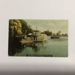 Port of Echuca
Coloured Postcard, W.T.P Post card, Original photograph probably taken late 1890's Postcard c. 1908 (postcard appears to be dated 08)
P. S. Adelaide was a logging steamer operating between Echuca and Barmah forest. It was built in 1866 by G. Linklater, Echuca. Original owner J. G. Grassie, Poon Boon Station & S. H. Officer, Murray Downs Station. In June 1891 she was purchased by Murray River Sawmills and spent most of her working life on the Barmah Forest run. In 1960 she was purchased by Echuca Apex Club and steamed to Echuca. Installed on a bed of cement in Hopwood Gardens, Echuca before being restored to be refloated as a significant addition to the Port of Echuca maritime fleet (Parsons, R. Ships of the Inland Rivers. 2005. p.46)The P.S Adelaide is extremely significant as it it the oldest known wooden hulled paddle steamer in the world. She was built in Echuca in 1866 and still operates on the Murray River today. She has worked in the Wool Industry, the Timber Industry and the Tourist Industry.Colour (hand painted?) postcard and colour negative f P. S. Adelaide towing an outrigger barge. Three men can be seen on the lower deck and one on the top deck.on the front of the postcard:". Log barge & steamer Echuca" On the bow of the steamer: "Adelaide". On reverse of postcard, in blue pen:" PORT 16.3.82 COL NEG 13x18x1." In black pen encased in a square:"396.1" In blue fountain pen. Letter addressed to "Mrs. J. Robertson 37 Roxburgh St. Ascot Vale." " Your letter to hand(?) Sat. I am much better since my trip away. Was sorry to hear Jess(?) was not well. Hope she is better again. Hoping all are well. Love to all H." Postcard stamped: "Echuca Victoria Ap 6 08" Printed in green "Post W.T.P. Card". In has a red one penny postage stamp in top right hand corner.p. s. adelaide, echuca, port of (riverboats), echuca - history, post cards, echuca, paddle steamers, timber barges -
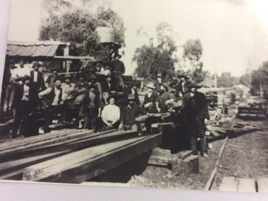 Port of Echuca
Black and white photograph
Macintosh's sawmill was on the banks of the Murray River in Echuca east where the Banyule State forest is now located. A tramway ran out to it from the main rail line near the iron bridge. Macintoshes Sawmill was one of the largest in the area. (Ref. Clare Jackson. )Macintoshes sawmill was set up by James Macintosh in 1868 in Echuca East. His sawmill prospered and in 1878 was "equal to five normal sawmills" (Ref; Coulson, Helen, "Echuca Moama On the Murray." P.158) He also owned 2 paddle steamers and 8 barges. The Macintosh Family contributed substantially to the development of Echuca East, but by 1901 the Family was in severe debt and were forced to sell the sawmill to the Nicholas Family.A black and white photograph of a large group of men outside a sawmill, reputed to be Macintoshes Sawmill in Echuca East.On the back of the photograph written in pencil are the words "Believed to be workmen at McIntosh's mill (Charlie Dowell says)macintosh's sawmill, sawmill industry, echuca east, banyule state forest, macintosh james, dowell, charlie, logging industry, jackson, clare -
Federation University Historical Collection
Book - Book - Scrapbook, University of Ballarat: Scrapbook of Newspaper cutting; Book 1, January 1998 to April 1998
Newspaper cuttings relating to the University of Ballarat, SMB Campus. These are from various newspapers and include The Age, Ballarat Courier, The Australian, The Herald. The cuttings cover the period from 1 January 1998 to 4 April 1998. . `Book with yellow cover, front. Spiral bound.employment advertisements, application for enrolment, outline of courses, university of ballarat, smb campus, ub, new university opens, secretaries conference, h h smith, artist's legacy, amalie colquhom, anne beggs sunter, director of tafe, peter morey, work skills olympics, peter bailey gold medallist, meat industry workers, joint venture, tafe prepares to deliver courses, jobs pathway program, professor geoffrey blainey, professor david caro, chancellor, michael aldermann, centrelink first call for jobless, colour and great music, marion's pots, marion popplewell, doug sarah - community service identity, michael adermann, neville french - potter, exhibition in new york, farm field day, ballarat demonstration farm, vocational training critical, powerful drama at the courthouse, $1.5m ararat campus opened, combined talents forge forest course, apprenticeship program begins -
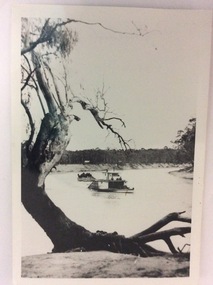
 Marysville & District Historical Society
Photograph (item) - Colour photograph, 04-1960
A colour photograph of the entrance to a fire dugout on Mount Margaret near Marysville in Victoria.A colour photograph of the entrance to a fire dugout on Mount Margaret near Marysville in Victoria. The fire refuge dugout, which developed in the era of bush sawmilling in the early twentieth century, was a distinctive cultural response to the history of fire in the tall Victorian forests. Few dugouts were built in other forest regions of Australia, but those that did exist in these Victorian ranges saved dozens of lives in the fires of Black Friday 1939.27 'Fire Dug out' Mt Margaret April 1960mount margaret, marysville, victoria, fire dugout, sawmilling industry, black friday 1939, bushfire -
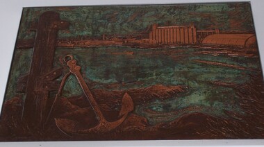 Glenelg Shire Council Cultural Collection
Sculpture - Bas-relief, Untitled (Early Forestry Industries), n.d
... -relief copper industry forestry forest Copper relief work. View ...Commissioned by State Bank to produce 5 copper bas-reliefs for 73 Percy Street, Portland. Spoke with Miss Betty Vivian (Member of the Portland Historical Society) re Portland's history. Commonwealth Bank stored objects in Melbourne (c.1991). Negotiations between Portland Historical Society and Commonwealth Bank of Australia led to gift of works to People of Portland. Stored at Council depot c.1998, retrieved for Maritime Discovery Centre display.Copper relief work. View of a man from behind sawing a tree. He is flanked by two tree trunks, and is leaning to his right while pulling a band saw through the tree on the left. Leaning against tree on right is a large axe. Houses are rudimentarily designated by lines in the background visible between the trees.sculpture, bas-relief, copper, industry, forestry, forest -
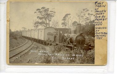 Ararat & District Historical Society (operating the Langi Morgala Museum)
Photograph, 1895
This photo of the first train from Ararat to the Portland Freezing Works in 1895 is a visual record of transport and industry in the early industrialisation of the region.Black and white photograph mounted on cardboard, featuring a steam engine with nine carriages and five men. The train has stopped in a siding surrounded by forest. The photo has text written along the right side of the image and repeated across the face of the photograph. Further information is written on the rear.Front: "First Train / Portland Freezing Works / from Ararat." "FIRST / TRAIN / OF / FROZEN / MEAT / RUN BY / ARARAT / LOCO / MEN / SIDING / AT / PORTLAND / FACTORY / 1895" Rear: "1st train ["loading" is struck out] / 1st train of frozen meat / run by Ararat Loco men / Siding at Portland Factory / 1895".locomotive, train, portland, ararat, portland-freezing-works, railway-siding, 1895 -
 Kiewa Valley Historical Society
Postcard Circa 1950, Lake Guy Dam and Bogong Village, Circa 1950
This postcard was produced in the 1950's for the tourist trade in the Kiewa Valley and Alpine region. It encompasses the period when the State of Victoria was pressured by the ever increasing demand by industry and its population for electricity supplies. Hydro electricity was seen as an untapped natural resource to quench this demand. The Victorian Alps and the rivers flowing into its valleys was ideal for the construction of the Kiewa Hydro Electricity Scheme. The late 1940's saw the development of this scheme and the changing of sections of alpine landscape is covered by this and other postcards/pictures (tourists, construction workers, and established rural populations). This period in time was before the established wildlife and forest/nature groups became political activist who changed legislative acts to protect the environment.This rural region (Kiewa Valley/alpine plains) was at most only significant to a smaller group of winter sports, summer hikers/horse riders and rural farmers/graziers. The numbers of tourists and the increase in the local resident population was boosted by the construction of the Hydro Electricity Scheme. This influx to the regional population resulted in a corresponding diversity in services and brought about an environment that responded to a growing level of tourists and thereby permitting this industry to grow more rapidly than it would have naturally. This postcard details an attraction to the "cleaner" method of providing electricity. This postcard was purchased in 1950 by a surveyor at Landford's Gap.This black and white photograph from a Valentine's postcard is from a V2 Argus photograph postcard. It is on a 200g/m paper density photo side gloss. See 0480 (B) - (F) for other photos of similar postcards.In white lettering " LAKE GUY & BOGONG VILLAGE KIEWA HYDRO-ELECTRIC PROJECT"kiewa valley tourism, victorian alps, alternate energy supplies, alpine population growth -
 Kiewa Valley Historical Society
Postcard Circa 1950, Snowfall at Bogong Village Kiewa Hydro-Electric Project, 1950s
This postcard was produced in the 1950's for the tourist trade in the Kiewa Valley and Alpine region. It encompasses the period when the State of Victoria was pressured by the ever increasing demand by industry and its population for electricity supplies. Hydro electricity was seen as an untapped natural resource to quench this demand. The Victorian Alps and the rivers flowing into its valleys was ideal for the construction of the Kiewa Hydro Electricity Scheme. The late 1940's saw the development of this scheme and the changing of sections of alpine landscape is covered by this and other postcards/pictures (tourists, construction workers, and established rural populations). This period in time was before the established wildlife and forest/nature groups became political activist who changed legislative acts to protect the environment.This rural region (Kiewa Valley/alpine plains) was at most only significant to a smaller group of winter sports, summer hikers/horse riders and rural farmers/graziers. The numbers of tourists and the increase in the local resident population was boosted by the construction of the Hydro Electricity Scheme. This influx to the regional population resulted in a corresponding diversity in services and brought about an environment that responded to a growing level of tourists and thereby permitting this industry to grow more rapidly than it would have naturally. This postcard details an attraction to the "cleaner" method of providing electricity. This postcard was purchased in 1950 by a surveyor at Landford's Gap.This scanned black and white photograph of a postcard, shows vehicles covered in thick snow at Bogong Village in 1950. See 0480(A), (C) - (F) for other similar photos of postcards available at this period."SNOWFALL AT BOGONG VILLAGE KIEWA HYDRO-ELECTRICITY PROJECT"kiewa valley tourism, victorian alps, alternate energy supplies, alpine population growth, bogong village, secv