Showing 3210 items matching "government roads"
-
 Bayside Gallery - Bayside City Council Art & Heritage Collection
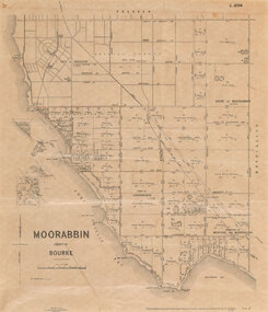
Map, Department of Crown Lands and Survey et al, Moorabbin, County of Bourke, Government Roads, 1920
... Moorabbin, County of Bourke, Government Roads......Government Roads...The cadastral map of the Parish of Moorabbin in Victoria (L.6104) shows parish boundaries and land ownership 1920 when Sandringham was a Town. The government roads have been coloured in red pencil....It is printed in black ink on cream paper and shows street names, subdivision of blocks, sizes of the blocks and the names of the landowners, and the government roads are coloured in red pencil. Port Phillip Bay is on the left, with land extending from Sandringham foreshore through to Cheltenham. ...Moorabbin, County of Bourke, Government Roads Map map Department of Crown Lands and Survey W.J. ...The cadastral map of the Parish of Moorabbin in Victoria (L.6104) shows parish boundaries and land ownership 1920 when Sandringham was a Town. The government roads have been coloured in red pencil.moorabbin, county of bourke, map, plan, land subdivision, land titles, foreshores, hampton, beaumaris, highett, cheltenham, department of lands and survey, land owners, cartographic material, brighton, sandringham, town of sandringham, government roads -
 Phillip Island and District Historical Society Inc.
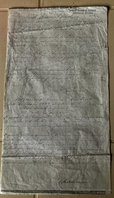
Document, First Annual Meeting minutes of Roads Board 1871
... Local government...Roads...Historical Local government Roads board Solomon West James Forster John Houston First annual meeting held at Bauer's hotel on 15 November 1871at 12 o'clock Foolscap photocopy of handwritten minutes of the first annual meeting of the Roads Board, appointing Mr James Forster as Chairman. ...A Phillip Island Road Board was formed in 1871. It was absorbed by Phillip Island and Woolamai Shire in 1874.HistoricalFoolscap photocopy of handwritten minutes of the first annual meeting of the Roads Board, appointing Mr James Forster as Chairman. Also minutes of adjoined general meeting, held later the same day, appointing John Houston was Clerk and all meetings be held at Bauer's Hotel.First annual meeting held at Bauer's hotel on 15 November 1871at 12 o'clocklocal government, roads board, solomon west, james forster, john houston -
 Lakes Entrance Historical Society
Map - Kalimna
... Map shows reserve, private streets and Government roads in the township of Kalimna. Shows Princes Highway...Lakes Entrance Historical Society 4 Marine Parade Lakes Entrance gippsland Roads and Streets Township Highways Map shows reserve, private streets and Government roads in the township of Kalimna. Shows Princes Highway Map Kalimna ...Map shows reserve, private streets and Government roads in the township of Kalimna. Shows Princes Highwayroads and streets, township, highways -
 Federation University Historical Collection
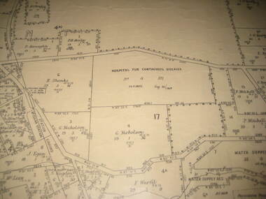
Plan - Plan - Cadastral, Parish of Ballaarat - Sheet 3 (only), 03/03/1932
... Sheet 3 of the Parish of Ballart showing Government roads, crown allotments, dimensions, crown grantees, date of grants, etc,...Barker Library (top floor) Mount Helen goldfields ballarat plan hospital for contagious diseases sebastopol sebastopol rifle range fiscalini leigh river yarrowee creek Sheet 3 of the Parish of Ballart showing Government roads, crown allotments, dimensions, crown grantees, date of grants, etc, Parish of Ballaarat - Sheet 3 (only) Plan Plan - Cadastral ...Sheet 3 of the Parish of Ballart showing Government roads, crown allotments, dimensions, crown grantees, date of grants, etc,ballarat, plan, hospital for contagious diseases, sebastopol, sebastopol rifle range, fiscalini, leigh river, yarrowee creek -
 Greensborough Historical Society
Maps, Greensborough. Parish Plan 1860, 1860c
... One copy possibly from 1860, containing lot numbers for a government road, now Main Street, and surrounding streets....Greensborough Historical Society 34A Glenauburn Road Lower Plenty Lower Plenty melbourne This plan show Green's subdivision of Greensborough, north of Grimshaw Street. greensborough grimshaw street greensborough edward bernard green One copy possibly from 1860, containing lot numbers for a government road, now Main Street, and surrounding streets. ...This plan show Green's subdivision of Greensborough, north of Grimshaw Street.Enlargements of Parish plan circa 1860?One copy possibly from 1860, containing lot numbers for a government road, now Main Street, and surrounding streets.greensborough, grimshaw street greensborough, edward bernard green -
![Map, Liquidator's sale, 1896. [Woolpack Estate, Bacchus Marsh]](/media/collectors/5e461d8021ea67224c82f2a1/items/6779ee97032b72846b5995f2/item-media/6779ef33032b72846b599b30/item-fit-380x285.jpg?cb=6) Bacchus Marsh & District Historical Society
Bacchus Marsh & District Historical SocietyMap, Liquidator's sale, 1896. [Woolpack Estate, Bacchus Marsh]
... Also shown on the map are lots for sale at Robinson's Farm on Coimadai Creek and allotments near Bacchus Marsh railway station, including lots on Government Road (East Maddingley Road), View Street and Government Road (Parwan Road). ...Also shown on the map are lots for sale at Robinson's Farm on Coimadai Creek and allotments near Bacchus Marsh railway station, including lots on Government Road (East Maddingley Road), View Street and Government Road (Parwan Road). ...The Woolpack Estate was an area of land owned by various landowners in the Bacchus Marsh area since the early Colonial period of the 1840s. The area was located on the eastern side of the Bacchus Marsh township about 7 kilometers from the town. The Lerderderg River ran through part of the land and so did the Melbourne to Ballarat Road. The historic Woolpack Inn associated with James Crook was also located on this land. By 1896 150 acres of this land was under the control of liquidators for the Federal Bank of Australasia who instructed that the land be sub-divided and sold in lots by public auction. A successful sale was held on 24 June 1896. Most of the blocks of land were sold for higher than expected prices and most of the buyers were people from the town and district of Bacchus Marsh. The map includes various details about the land which is described on the map as an "important sale of rich alluvial irrigable flat land in the Bacchus Marsh Valley, and other properties". The auction was conducted by the local agents W. Anderson and Bence in conjunction with Pearce Brothers also of Bacchus Marsh.A single page paper map showing a plan of 150 acres of land from the Woolpack Estate to be sold in various lots in June 1896. Also shown on the map are lots for sale at Robinson's Farm on Coimadai Creek and allotments near Bacchus Marsh railway station, including lots on Government Road (East Maddingley Road), View Street and Government Road (Parwan Road). No scale provided. The map is pasted into a bound volume containing 76 maps or plans in total. High resolution digital image stored on BMDHS computer network. land sales bacchus marsh, bacchus marsh victoria maps, woolpack estate bacchus marsh victoria -
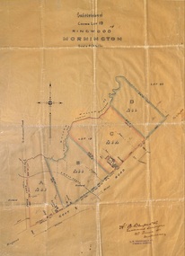 Ringwood and District Historical Society
Plan, Subdivision of Crown Lot 19, Ringwood, Victoria - circa 1915
... Subdivision map includes Mullum Creek, Government Road to Anderson's Creek, later Warrandyte Road, Government Road to Lillydale, later Whitehorse Road, small creek bridge, later Sandy Creek at Ringwood Lake. ...Ringwood and District Historical Society 125A Warrandyte Road Ringwood North melbourne Subdivision map includes Mullum Creek, Government Road to Anderson's Creek, later Warrandyte Road, Government Road to Lillydale, later Whitehorse Road, small creek bridge, later Sandy Creek at Ringwood Lake. ...Surveyor's map on wax paperSubdivision map includes Mullum Creek, Government Road to Anderson's Creek, later Warrandyte Road, Government Road to Lillydale, later Whitehorse Road, small creek bridge, later Sandy Creek at Ringwood Lake. Buildings marked include Roman Catholic Church, O.J. Pratt's House and Pratt's butcher shop (photos attached). Map by A.B. Bruford & Co., Licensed Surveyor, 47 Queen Street, Melbourne. -
Federation University Historical Collection
Map, Town of Buninyong, 1927, 09/1927
... Township plan of the Town of Buninyong showing government roads and crown allotments. Earlier detail pencilled on (commercial buildings, etc) appears to be from an 1850 survey. ...Buninyong was created a district on 09 July 1858, proclaimed a Shire on 16 February 1864, and the Buninyong Borough united on 01 October 1915. buninyong map buninyong botanical gardens tannery dam buninyong reservoir chapel school rev. hastie Township plan of the Town of Buninyong showing government roads and crown allotments. Earlier detail pencilled on (commercial buildings, etc) appears to be from an 1850 survey. ...The date of this map is September 1927 revised from the original 1910 map. Buninyong was created a district on 09 July 1858, proclaimed a Shire on 16 February 1864, and the Buninyong Borough united on 01 October 1915.Township plan of the Town of Buninyong showing government roads and crown allotments. Earlier detail pencilled on (commercial buildings, etc) appears to be from an 1850 survey. Scale: 4 chains to 1 inch (1:3168)buninyong, map, buninyong botanical gardens, tannery dam, buninyong reservoir, chapel school, rev. hastie -
Whitehorse Historical Society Inc.
Document, Constituting a road district to be a shire, 1872
... government...Nunawading District Roads Board...Copy from Ivan Southall's 'A Tale of Box Hill', constitution of Nunawading District Road Board to the Shire of Nunawading, extract from Government Gazette, 3 May 1872....Whitehorse Historical Society Inc. 2-10 Deep Creek Road Mitcham melbourne Local government Nunawading District Roads Board Shire of Nunawading Copy from Ivan Southall's 'A Tale of Box Hill', constitution of Nunawading District Road Board to the Shire of Nunawading, extract from Government Gazette, 3 May 1872. ...Copy from Ivan Southall's 'A Tale of Box Hill', constitution of Nunawading District Road Board to the Shire of Nunawading, extract from Government Gazette, 3 May 1872.Copy from Ivan Southall's 'A Tale of Box Hill', constitution of Nunawading District Road Board to the Shire of Nunawading, extract from Government Gazette, 3 May 1872.Copy from Ivan Southall's 'A Tale of Box Hill', constitution of Nunawading District Road Board to the Shire of Nunawading, extract from Government Gazette, 3 May 1872.local government, nunawading district roads board, shire of nunawading -
Whitehorse Historical Society Inc.
Document, Electing members of the District Road Board, 1862
... government...Nunawading District Roads Board...Whitehorse Historical Society Inc. 2-10 Deep Creek Road Mitcham melbourne Extract from Road Board minute book, 10 Sept 1862. Local government Nunawading District Roads Board Copy from Ivan Southall''s 'A Tale of Box Hill', public meeting for the election of members of the Nunawading District Road Board, for fixing the rate for the current year and appointing auditors. ...Copy from Ivan Southall''s 'A Tale of Box Hill', public meeting for the election of members of the Nunawading District Road Board, for fixing the rate for the current year and appointing auditors.Copy from Ivan Southall''s 'A Tale of Box Hill', public meeting for the election of members of the Nunawading District Road Board, for fixing the rate for the current year and appointing auditors. Extract from Road Board minute book, 10 Sept 1862.Copy from Ivan Southall''s 'A Tale of Box Hill', public meeting for the election of members of the Nunawading District Road Board, for fixing the rate for the current year and appointing auditors.local government, nunawading district roads board -
Whitehorse Historical Society Inc.
Drawing - Illustration, Early Roads Board members
... government...Nunawading District Roads Board...Whitehorse Historical Society Inc. 2-10 Deep Creek Road Mitcham melbourne Local government Nunawading District Roads Board Yeomans William Boardman Pierce Aspinall Joseph Padgham Silas Copy from Ivan Southall's 'A Tale of Box Hill', photos of early Roads Board members. ...Copy from Ivan Southall's 'A Tale of Box Hill', photos of early Roads Board members.Copy from Ivan Southall's 'A Tale of Box Hill', photos of early Roads Board members.Copy from Ivan Southall's 'A Tale of Box Hill', photos of early Roads Board members.local government, nunawading district roads board, yeomans, william, boardman, pierce, aspinall, joseph, padgham, silas -
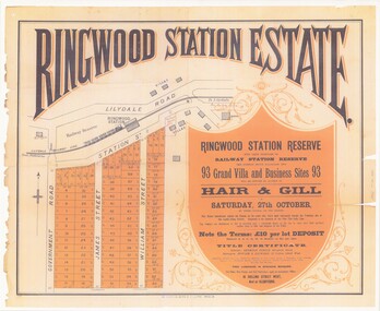 Ringwood and District Historical Society
Poster - Auction, Ringwood Station Estate, Ringwood, Victoria - circa 1925
... Subdivision includes Station Street, Government Road (Wantirna Road), James Street, William Street. ...Ringwood and District Historical Society 125A Warrandyte Road Ringwood North melbourne Subdivision includes Station Street, Government Road (Wantirna Road), James Street, William Street. ...Colour photocopy of poster sub-titled Ringwood Station Reserve & Railway Station Reserve. Auction of 93 sites on Saturday 27th October (no year, likely 1925). Subdivision includes Station Street, Government Road (Wantirna Road), James Street, William Street. Auctioneers - Hair & Gill, 16 Collins Street West and Glenferrie. Solicitor - Seymour Fergie, Elizabeth Street. Surveyors - Fowler & Gatward, 12 Collins Street West. -
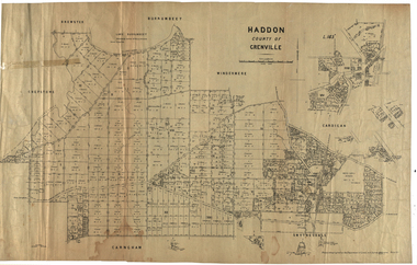 Federation University Historical Collection
Plan, Haddon, County of Grenville, 1932, 13/04/1932
... The Haddon Parish Plan shows crown parcels government roads, Crown Reserves, Railway. Scale 40 chains to 1" (1:31, 680) WGS 84 Centroid Lat: 37 degrees 34' 00" S Long: 148 degrees 40' 20" E N.S. 9.3km E.W.: 16.1km...haddon grenville cardigan water supply reserve nentingbook pre-emptive right a. mclachlan lake burrumbeet e.a. wynne p. russell b. hepburn benjamin hepburn nentingbool t.c. wilson j. amoy william collard smith james roach j. mitchell The Haddon Parish Plan shows crown parcels government roads, Crown Reserves, Railway. Scale 40 chains to 1" (1:31, 680) WGS 84 Centroid Lat: 37 degrees 34' 00" S Long: 148 degrees 40' 20" E N.S. 9.3km E.W.: 16.1km Haddon, County of Grenville, 1932 Plan Plan Department of Crown Lands and Survey, Melbourne ...The Haddon Parish Plan shows crown parcels government roads, Crown Reserves, Railway. Scale 40 chains to 1" (1:31, 680) WGS 84 Centroid Lat: 37 degrees 34' 00" S Long: 148 degrees 40' 20" E N.S. 9.3km E.W.: 16.1kmhaddon, grenville, cardigan, water supply reserve, nentingbook pre-emptive right, a. mclachlan, lake burrumbeet, e.a. wynne, p. russell, b. hepburn, benjamin hepburn, nentingbool, t.c. wilson, j. amoy, william collard smith, james roach, j. mitchell -
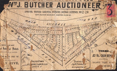 Ringwood and District Historical Society
Poster - Land Sale, Wm J. Butcher, Auctioneer - Albert Park Estate, Ringwood - c.1890
... Photocopied SLV image of original advertisement shows map of 117 allotments for sale in Main Lilydale Road (later Old Lilydale Road), Wandin Road (later Mount Dandenong Road), Joseph Street, Dynes Street, Albert Street (later Wyrunga Street) and Government Road (later Carcoola Road), Ringwood East....Photocopied SLV image of original advertisement shows map of 117 allotments for sale in Main Lilydale Road (later Old Lilydale Road), Wandin Road (later Mount Dandenong Road), Joseph Street, Dynes Street, Albert Street (later Wyrunga Street) and Government Road (later Carcoola Road), Ringwood East. ...Central section of land sale subdivision advertisement glued to heavy cardboard backing. Photocopied SLV image of original advertisement shows map of 117 allotments for sale in Main Lilydale Road (later Old Lilydale Road), Wandin Road (later Mount Dandenong Road), Joseph Street, Dynes Street, Albert Street (later Wyrunga Street) and Government Road (later Carcoola Road), Ringwood East.Solicitors - Jenningw & Wright, Queen Street. Surveyors - J.&H. Tarrant, Elizabeth Street. Terms £2 10s cash deposit, balance three years at six per cent. -
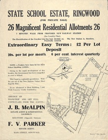 Ringwood and District Historical Society
Flyer, Land Sale Advertisement - State School Estate, Ringwood, Victoria - 1923
... Locality plan includes King Street and Government Roads (Later Everard Road, Holland Road, Purser Avenue, and Charles Street). ...Ringwood and District Historical Society 125A Warrandyte Road Ringwood North melbourne The date of the flyer as circa 1920 can be estimated from the references to the (decision on) "electrification of the Croydon Railway Line" which eventually occurred in 1923, letting of tenders for the state school building which opened in 1924, and the "proposed new railway station" (East Ringwood) which opened in 1925, Locality plan includes King Street and Government Roads (Later Everard Road, Holland Road, Purser Avenue, and Charles Street). ...The date of the flyer as circa 1920 can be estimated from the references to the (decision on) "electrification of the Croydon Railway Line" which eventually occurred in 1923, letting of tenders for the state school building which opened in 1924, and the "proposed new railway station" (East Ringwood) which opened in 1925, Advertisement for State School Estate, Ringwood - 26 residential allotments for sale near East Ringwood State School development site and 7 minutes walk from proposed new railway station (East Ringwood). Includes location map and terms of sale.Locality plan includes King Street and Government Roads (Later Everard Road, Holland Road, Purser Avenue, and Charles Street). (Agents) J.B. McAlpin, Estate Agent and Subdivisional Manager, Ringwood (Opposite Station), and F.V. Parker, Estate Agent, Main Street, Ringwood. -
 Emerald Museum & Nobelius Heritage Park
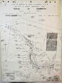
Map - Image of Plan of Deviation in Crown Allotments 57 & 58, Belgrave-Gembrook Rd., near Wright Rd. 1929, Plan of Deviation in Crown Allotments 57 & 58, Belgrave-Gembrook Rd., near Wright Rd. 1929, c1929
... CRB/Plan of Deviation in Crown Allotments 57 & 58 and Part of Former Government Road/Parish of Gembrook, County of Evelyn/Belgrave-Gembrook Rd....Emerald Museum & Nobelius Heritage Park 5 Crichton Rd Emerald yarra-valley-and-the-dandenong-ranges CRB/Plan of Deviation in Crown Allotments 57 & 58 and Part of Former Government Road/Parish of Gembrook, County of Evelyn/Belgrave-Gembrook Rd. ...Crown survey map showing plan of deviation in crown allotments 57 & 58, Belgrave-Gembrook Rd., near Wrights Rd., Parish of GembrookCRB/Plan of Deviation in Crown Allotments 57 & 58 and Part of Former Government Road/Parish of Gembrook, County of Evelyn/Belgrave-Gembrook Rd./Scale 100 foot to an inch/Certification of Plan (Signed) W.P. BONWICK, Surveyor Licensed under Act 2679/5-2-29/Survey Plan No. 2239 -
 Ringwood and District Historical Society
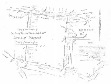
Document - Copy of Lands Department Field Notes - Parish of Ringwood, Victoria, Field Notes - Part of Crown Allotment 17D Surveyed 1952 (Amended in 1953)
... C.93151, Railway Reserve, Station Street, Bedford Road, multiple post & wire fences, multiple galv iron pipes put in, Government Road (Hill Street), Tooronga Road, multiple recent pegs found, Certification 52710 by J. ...C.93151, Railway Reserve, Station Street, Bedford Road, multiple post & wire fences, multiple galv iron pipes put in, Government Road (Hill Street), Tooronga Road, multiple recent pegs found, Certification 52710 by J. ...5616b Double foolscap size photocopy of survey map with handwritten notations. References include Corr no. C.93151, Railway Reserve, Station Street, Bedford Road, multiple post & wire fences, multiple galv iron pipes put in, Government Road (Hill Street), Tooronga Road, multiple recent pegs found, Certification 52710 by J. Fitzgerald Licensed Surveyor 17/3/1952. -
 Federation University Historical Collection
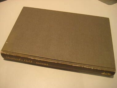
Book, C.E. Sayers, Shepherd's Gold: The Story of Stawell, 1966 (exact)
... Contents include Gold, squatters, Ayreys of Warranooke, Diggings, Reefs, Local Government, Road District, Shire, Borough, Town, Hospital, schools, Churches, Growth of Settlement, Claim Jumps, Sheep, Farming, Water, Grampians, Magdala, Callawadda, Deap Lead, Glenorchi, Great Western, Green's Creek, Marnoo, Wal Wal....Contents include Gold, squatters, Ayreys of Warranooke, Diggings, Reefs, Local Government, Road District, Shire, Borough, Town, Hospital, schools, Churches, Growth of Settlement, Claim Jumps, Sheep, Farming, Water, Grampians, Magdala, Callawadda, Deap Lead, Glenorchi, Great Western, Green's Creek, Marnoo, Wal Wal. ...One of the 6 University of Ballarat campuses is at Stawell.Grey hard covered book of 194 pages covering the history of Stawell, Victoria. Contents include Gold, squatters, Ayreys of Warranooke, Diggings, Reefs, Local Government, Road District, Shire, Borough, Town, Hospital, schools, Churches, Growth of Settlement, Claim Jumps, Sheep, Farming, Water, Grampians, Magdala, Callawadda, Deap Lead, Glenorchi, Great Western, Green's Creek, Marnoo, Wal Wal.education, religion, stawell victoria, stawell -
 Ringwood and District Historical Society
Plan, Plan of Subdivision No.11498 with handwritten costing notations - East Ringwood Central Estate c.1948
... Subdivision includes Knaith Road, Northwood Street, Langley Street, Bondi Street, and Government Road (later Alexandra Road), Ringwood East. ...Subdivision includes Knaith Road, Northwood Street, Langley Street, Bondi Street, and Government Road (later Alexandra Road), Ringwood East. ...Two handwritten pages showing layout of Subdivision no 11498 with surveyor notations including property sizes and road construction cost calculations. Drainage easement 6 feet wide shaded blue.Plan of Subdivision No. 11498, Part of Crown Allotment 27, Parish of Ringwood, County of Mornington, (Certificate of Title Vol 5120 Fol 1023945). Owner Mr Vogel. Subdivision includes Knaith Road, Northwood Street, Langley Street, Bondi Street, and Government Road (later Alexandra Road), Ringwood East. G. Parsons & Sons, Licensed Surveyors, 389 Flinders Lane (Melbourne). -
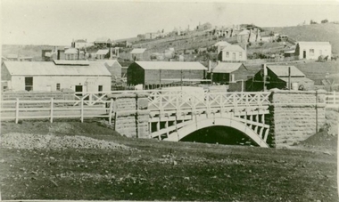
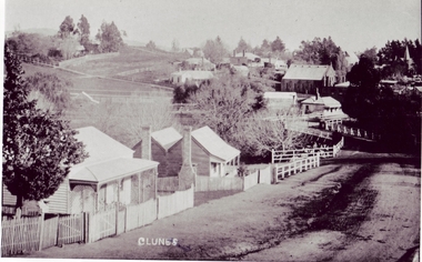 Clunes Museum
Photograph
... COPY OF STREET SCENE IN CLUNES, HOUSES IN CRESWICK ROAD, GOVERNMENT BRIDGE IN THE CENTRE, WITH BIBLE CHRISTIAN CHURCH IN BACKGROUND....Clunes Museum 36 Fraser Street enter building through Collins Place Clunes goldfields EARLY SCENE OF CLUNES local history photography photographs buildings COPY OF STREET SCENE IN CLUNES, HOUSES IN CRESWICK ROAD, GOVERNMENT BRIDGE IN THE CENTRE, WITH BIBLE CHRISTIAN CHURCH IN BACKGROUND. ...EARLY SCENE OF CLUNESCOPY OF STREET SCENE IN CLUNES, HOUSES IN CRESWICK ROAD, GOVERNMENT BRIDGE IN THE CENTRE, WITH BIBLE CHRISTIAN CHURCH IN BACKGROUND.local history, photography, photographs, buildings -
 Ringwood and District Historical Society
Document - Subdivision Plan, LP26914 Multiple Crown Allotments, Parish of Ringwood, County of Mornington, Vol 8021 Fol 053 - 1954
... Section B Map includes Bedford Road, Government Road (later Bedford Park Road then Hill Street), Marwarra Street and Tooronga Road, Ringwood. ...Section B Map includes Bedford Road, Government Road (later Bedford Park Road then Hill Street), Marwarra Street and Tooronga Road, Ringwood. ...LANDATA Land Victoria plan printout dated 2010Part of Crown Allotments 1, 1A, 2, 3, 4, 5, 6, 7, 8, 9, 10, 55, 56, 57. Section C Crown Allotments 3, 12 & part of 2. Section B Map includes Bedford Road, Government Road (later Bedford Park Road then Hill Street), Marwarra Street and Tooronga Road, Ringwood. (Sheet 1 of 2 - Sheet 2 not included with collection). -
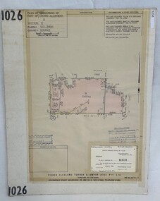 Greensborough Historical Society
Poster - Planning Document, Shire of Diamond Valley et al, Subdivision Plan # 1026 - Parish of Nillumbik, County Bourke, Crown Allotment B Section 12, Eltham North, 1981-1984
... This subdivision plan includes Ryans Road (also known as Government Road) and St Clems Street. The developer for this subdivision is Taunton Developments and the Surveyors are Fisher Cleeland Turner & Dwyer Vic, Surveyors and Engineers....This subdivision plan includes Ryans Road (also known as Government Road) and St Clems Street. The developer for this subdivision is Taunton Developments and the Surveyors are Fisher Cleeland Turner & Dwyer Vic, Surveyors and Engineers. ...Subdivision Plan # 1026 - Parish of Nillumbik, County Bourke, Crown Allotment B Section 12, Eltham North. This subdivision plan includes Ryans Road (also known as Government Road) and St Clems Street. The developer for this subdivision is Taunton Developments and the Surveyors are Fisher Cleeland Turner & Dwyer Vic, Surveyors and Engineers.An example of hard copy subdivision plans from the Greensborough area. Mainly from the Shire of Diamond Valley era (1964-1994).Plan (single sided) mounted on heavy card. Stamped and handwritten Council permissions, dates and other details. subdivision plans, shire of diamond valley, taunton developments -
Federation University Historical Collection
Document, Roads and Works in Grenville and Polworth, 1856, 1856
... Blue Foolscap printed Government document relating to roads and works in Grenville and Polworth. ...Barker Library (top floor) Mount Helen goldfields roads grenville polworth Blue Foolscap printed Government document relating to roads and works in Grenville and Polworth. ...Blue Foolscap printed Government document relating to roads and works in Grenville and Polworth. roads, grenville, polworth -
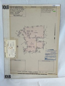 Greensborough Historical Society
Poster - Planning Document, Shire of Diamond Valley et al, Subdivision Plan # 1018 - Parish of Nillumbik, County Bourke, Crown Allotment 4 Section 15, and Crown Allotment B Section 12, Eltham North, 1981-1982
... This subdivision plan includes Ryans Road (also known as Government Road) and St Clems Street. The developer for this subdivision is Taunton Developments and the Surveyors are Fisher Cleeland Turner & Dwyer Vic, Surveyors and Engineers....This subdivision plan includes Ryans Road (also known as Government Road) and St Clems Street. The developer for this subdivision is Taunton Developments and the Surveyors are Fisher Cleeland Turner & Dwyer Vic, Surveyors and Engineers. ...Subdivision Plan # 1018 - Parish of Nillumbik, County Bourke, Crown Allotment 4 Section 15, and Crown Allotment B Section 12, Eltham North. This subdivision plan includes Ryans Road (also known as Government Road) and St Clems Street. The developer for this subdivision is Taunton Developments and the Surveyors are Fisher Cleeland Turner & Dwyer Vic, Surveyors and Engineers.An example of hard copy subdivision plans from the Greensborough area. Mainly from the Shire of Diamond Valley era (1964-1994).Plan (single sided) mounted on heavy card. Stamped and handwritten Council permissions, dates and other details. subdivision plans, shire of diamond valley, taunton developments -
 Bayside Gallery - Bayside City Council Art & Heritage Collection
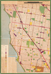
Map - print, Melbourne and Metropolitan Board of Works, Interim development order: Brighton, Moorabbin and Sandringham, 1959
... It also shows open spaces, public purposes (eg, hospitals, schools, local government), railways, roads, cemeteries and waterways....It also shows open spaces, public purposes (eg, hospitals, schools, local government), railways, roads, cemeteries and waterways. ...The Melbourne and Metropolitan Board of Works (now Melbourne Water) was established in 1891. From that time, as part of their work laying water and sewerage connections, they created detailed plans of houses and other buildings in the Melbourne metropolitan area. In 1956 it acquired powers to construct and maintain highways and bridges, protect and improve the foreshores and create and maintain parks within the metropolitan region. This Interim development order comprises part of the municipalities of Brighton, Moorabbin and Sandringham and was made on 20 October 1959.brighton, moorabbin, sandringham, melbourne and metropolitan board of works, map, town planning, cartographic material, interim development order, bayside -
 Dandenong & District Historical Society
Journal, Dandenong & District Historical Society, Gipps-Land Gate Vol.5 No.2, 1976
... Keeping Posted Local Government 1870 Roads Board Style Origns of The Name 'Yarraman' and some Yarraman History This Was Dandenong ...Keeping Posted Local Government 1870 Roads Board Style Origns of The Name 'Yarraman' and some Yarraman History This Was Dandenong Gipps-Land Gate Vol.5 No.2 Journal Dandenong & District Historical Society ...An interesting group of Early Dandenong Personalities, Places and EventsA5 size publication of the Gipps-Land Gate, December 1974. 16 pages, featuring an old picture of Dandenong on the cover. Keeping Posted Local Government 1870 Roads Board Style Origns of The Name 'Yarraman' and some Yarraman History This Was Dandenong An interesting group of Early Dandenong Personalities, Places and Eventshotel history, early education in dandenong, interesting milestones, family histories -
 Dandenong & District Historical Society
Journal, Dandenong & District Historical Society, Gipps-Land Gate Vol.5 No.4, 1976
... Keeping Posted Local Government 1870 Roads Board Style Origns of The Name 'Yarraman' and some Yarraman History This Was Dandenong ...Keeping Posted Local Government 1870 Roads Board Style Origns of The Name 'Yarraman' and some Yarraman History This Was Dandenong Gipps-Land Gate Vol.5 No.4 Journal Dandenong & District Historical Society ...An interesting group of Early Dandenong Personalities, Places and EventsA5 size publication of the Gipps-Land Gate, December 1974. 16 pages, featuring an old picture of Dandenong on the cover. Keeping Posted Local Government 1870 Roads Board Style Origns of The Name 'Yarraman' and some Yarraman History This Was Dandenong An interesting group of Early Dandenong Personalities, Places and Eventshotel history, early education in dandenong, interesting milestones, family histories -
 Clunes Museum
Photograph
... PHOTOGRAPH OF GOVERNMENT BRIDGE OVER CRESWICK CREEK ON CRESWICK ROAD, CLUNES. PHOTOGRAPH DONATED BY CRESWICK MUSEUM. ...BLACK AND WHITE PHOTOGRAPH OF BRIDGE OVER CRESWICK CREEK AT CLUNES - GOVERNMENT BRIDGE, CRESWICK ROAD. EBERHARDS SOFT DRINK FACTORY IN CENTRE OF PHOTOGRAPH....SEMMENS FROM AN EARLIER PHOTOGRAPH. local history photography photographs BLACK AND WHITE PHOTOGRAPH OF BRIDGE OVER CRESWICK CREEK AT CLUNES - GOVERNMENT BRIDGE, CRESWICK ROAD. EBERHARDS SOFT DRINK FACTORY IN CENTRE OF PHOTOGRAPH. ...PHOTOGRAPH OF GOVERNMENT BRIDGE OVER CRESWICK CREEK ON CRESWICK ROAD, CLUNES. PHOTOGRAPH DONATED BY CRESWICK MUSEUM. COPIED BY MR. SEMMENS FROM AN EARLIER PHOTOGRAPH.BLACK AND WHITE PHOTOGRAPH OF BRIDGE OVER CRESWICK CREEK AT CLUNES - GOVERNMENT BRIDGE, CRESWICK ROAD. EBERHARDS SOFT DRINK FACTORY IN CENTRE OF PHOTOGRAPH.local history, photography, photographs -
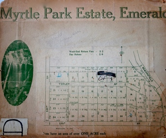 Kew Historical Society Inc
Plan - Subdivision Plan, Myrtle Park Estate, Emerald, 1915
... The subdivision in Emerald included 32 one-acre lots facing Torley Road, Government Road (now Rawhiti and Wong Hee Roads) Beaconsfield Road (now Old Beaconsfield Road). ...The subdivision in Emerald included 32 one-acre lots facing Torley Road, Government Road (now Rawhiti and Wong Hee Roads) Beaconsfield Road (now Old Beaconsfield Road). ...This subdivision plan for the ‘Myrtle Park Estate’ relates to land sales in Emerald, Victoria, rather than to the subdivision of the same name in East Kew (1913-16). The subdivision in Emerald included 32 one-acre lots facing Torley Road, Government Road (now Rawhiti and Wong Hee Roads) Beaconsfield Road (now Old Beaconsfield Road). On the plan, an unnamed creek flows through allotments 8-12 on the east side of the Estate. The photograph of a waterfall and the advertised price of Day Return and Weekend Return Fares provide an indication of who the prospective purchasers were likely to be.subdivision plans - emerald, myrtle park estate, torley road -- emerald (vic.) -
 Dandenong & District Historical Society
Journal, Dandenong & District Historical Society, Gipps-Land Gate Vol.5 No.3, 1976
... Keeping Posted Turning Back The Pages 75 Years Local Government 1870 Roads Board Style This Was Dandenong "Laurel Lodge Recollections" ...Keeping Posted Turning Back The Pages 75 Years Local Government 1870 Roads Board Style This Was Dandenong "Laurel Lodge Recollections" Gipps-Land Gate Vol.5 No.3 Journal Dandenong & District Historical Society ...An interesting group of Early Dandenong Personalities, Places and EventsA5 size publication of the Gipps-Land Gate, December 1974. 16 pages, featuring an old picture of Dandenong on the cover. Keeping Posted Turning Back The Pages 75 Years Local Government 1870 Roads Board Style This Was Dandenong "Laurel Lodge Recollections" An interesting group of Early Dandenong Personalities, Places and Eventshotel history, early education in dandenong, interesting milestones, family histories