Showing 46 items matching "kew pound"
-
 Kew Historical Society Inc
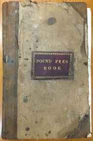
Administrative record (item), Borough of Kew, Pound Fees Book, 1874-1896
... glass creek pound (kew)...While the first successful land sales in Boroondara occurred in Hawthorn in 1843, and Kew in 1845, these areas were to be without local pounds until April 1858, when the Governor of Victoria, in accordance with Act 18 Victoria No 30, was pleased to direct the establishment of a Pound at Glass’s Creek on that part of land bounded by the Kilby Road, Burke Road and High Street. ...Leather Bound official register of the Glass Creek Pound, [East] Kew. Mr. J. Smith of Laburnum donated the register to the Society in July 1992 after it was discovered on a local rubbish tip. ..."Kew Pound Book"..., who both claimed the Pound following their separation from the Boroondara Roads Board in 1861. glass creek pound (kew) animal pound dog pound kew pound j. smith john oakes samuel b. cash edward s. delaney emma oswin samuel cash "Kew Pound Book" Leather Bound official register of the Glass Creek Pound, [East] Kew. ...While the first successful land sales in Boroondara occurred in Hawthorn in 1843, and Kew in 1845, these areas were to be without local pounds until April 1858, when the Governor of Victoria, in accordance with Act 18 Victoria No 30, was pleased to direct the establishment of a Pound at Glass’s Creek on that part of land bounded by the Kilby Road, Burke Road and High Street. While the Governor was required to proclaim the establishment of a pound, the appointment of a poundkeeper was the responsibility of the Justices of the Peace in the local Court of Petty Sessions. The Pound took its name from the most distinctive natural feature of the area, Glass’s Creek, named after the early pastoralist Thomas Glass.The register is of historic significance as an indicator of suburban life in the second half of the 19th Century. It shows how farming and city life on the urban fringe were intimately connected. It is also significant to the early history of Hawthorn and Kew, who both claimed the Pound following their separation from the Boroondara Roads Board in 1861."Kew Pound Book"glass creek pound (kew), animal pound, dog pound, kew pound, j. smith, john oakes, samuel b. cash, edward s. delaney, emma oswin, samuel cash -
 Kew Historical Society Inc
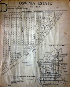
Plan - Subdivision Plan, Oswinia Estate, East Kew, c.1925
... The only piece of land excluded was that where the previous Kew Pound had been located at the east tip of the triangle. ...The only piece of land excluded was that where the previous Kew Pound had been located at the east tip of the triangle. ...Prue Sanderson, in her groundbreaking ‘City of Kew Urban Conservation Study : Volume 2 - Development History’ (1988), summarised the periods of urban development and subdivisions of land in Kew. The periods that she identified included 1845-1880, 1880-1893, 1893-1921, 1921-1933, 1933-1943, and Post-War Development. These periods were selected as they represented periods of rapid growth or decline in urban development. An obvious starting point for Sanderson’s groupings involved population growth and the associated economic cycles. These cycles also highlighted urban expansion onto land that was predominantly rural, although in other cases it represented the decline and breakup of large estates. A number of the plans in the Kew Historical Society’s collection can also be found in other collections, such as those of the State Library of Victoria and the Boroondara Library Service. A number are however unique to the collection.Subdivision plans are historically important documents used as evidence of the growth of suburbs in Australia. They frequently provide information about when the land was sold on which a built structure was subsequently constructed as well as evidence relating to surveyors and real estate and financial agents. The numerous subdivision plans in the Kew Historical Society's collection represent working documents, ranging from the initial sketches made in planning a subdivision to printed plans on which auctioneers or agents listed the prices for which individual lots were sold. In a number of cases, the reverse of a subdivision plan in the collection includes a photograph of a house that was also for sale by the agent. These photographs provide significant heritage information relating house design and decoration, fencing and household gardens.The ‘Oswinia Estate’ subdivision in East Kew was planned and auctioned in the first half of the 1920s. 169 allotments were created in the triangular section of land bordered by High Street, Burke Road and the Government Boulevard (later Kilby Road). The only piece of land excluded was that where the previous Kew Pound had been located at the east tip of the triangle. Allotments were created fronting Glass, High, Namur, Oswin Streets, Irymple Avenue, and the Government Boulevard. The name for the Estate was derived from Oswin’s farm, which had been one of the largest landholdings in East Kew. The selling agents annotated the plan in our collection with crosses indicating those lots that had been sold. The inset locality plan is particularly interesting as it shows the route and stations of the Outer Circle Railway. When the subdivision plan was created, it included the proposed bridge over the Yarra at Burke Road. The bridge was to be officially opened in 1926.subdivision plans - east kew, oswinia estate, high street, glass street, namur street, government boulevard - kilby road, irymple street, oswin street -
 Port Melbourne Historical & Preservation Society
Document - Contract of Sale for 84 Dow Street, Port Melbourne, Law Institute of Victoria, 8 July 1982
... The land was sold by Catherine Fleming BARLOW of East Kew to Sydney William NEWMAN for the sum of 875 pounds. The deposit was 100 pounds with a quarterly re-payment of 10 pounds....The land was sold by Catherine Fleming BARLOW of East Kew to Sydney William NEWMAN for the sum of 875 pounds. The deposit was 100 pounds with a quarterly re-payment of 10 pounds. ...The 1928 Contract of Sale is for the land which became 84 Dow Street, Port Melbourne. The land was sold by Catherine Fleming BARLOW of East Kew to Sydney William NEWMAN for the sum of 875 pounds. The deposit was 100 pounds with a quarterly re-payment of 10 pounds.Purchase completeddow street, built environment - domestic -
 Ringwood and District Historical Society
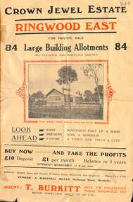
Flyer, Subdivisional Land Sale Brochure, Crown Jewel Estate, Ringwood East, Vic. - c.1925
... In May 1884, George Smart of Bulleen Road Kew, brickmaker, bought the 23 acres one rood and twenty nine and three tenths perches, or 9.4834 hctares from Arthur Bailey Clements of Ringwood for the sum of 600 pound sterling. ...Ringwood and District Historical Society 125A Warrandyte Road Ringwood North melbourne In May 1884, George Smart of Bulleen Road Kew, brickmaker, bought the 23 acres one rood and twenty nine and three tenths perches, or 9.4834 hctares from Arthur Bailey Clements of Ringwood for the sum of 600 pound sterling. ...In May 1884, George Smart of Bulleen Road Kew, brickmaker, bought the 23 acres one rood and twenty nine and three tenths perches, or 9.4834 hctares from Arthur Bailey Clements of Ringwood for the sum of 600 pound sterling. (Extract from The Story of the Crown Jewel Estate in Ringwood East pdf)Double sided folded page with black and red print on both sides advertising auction sale of residential and business sites and highlighting local facilities, services and layout of the estate.Subdivision includes Mount Dandenong Road, Valda Avenue, Evon Avenue, Mirabel Avenue, and Velma Grove. (Agent) T. Burkitt, Box 12 Ringwood, Phone Ringwood 157. Vendor: A. Marshall Miller, McDonald Street, Mordialloc. Solicitors: Russell, Bona and Russell, 19 Queen Street Melbourne, and Ringwood - Phone Cent. 4308. -
 Villa Alba Museum
Decorative object - Wallpaper sample, Red Floral Bouquets PR15234
... Kew melbourne The Villa Alba Museum is cultural institution committed to the collection, study and display of 19th century interior decorative finishes, and the components of 19th and 20th century interior decoration. These include artefacts (wallpapers, textiles, carpet samples), furnishings, printed materials (catalogues, books, periodicals), and pictures (photographs). decorative arts & design wall coverings – history wallpapers – history interior decoration – history Verso: "PR 15234 * 19 [pounds] 50p E.W. ...The Villa Alba Museum is cultural institution committed to the collection, study and display of 19th century interior decorative finishes, and the components of 19th and 20th century interior decoration. These include artefacts (wallpapers, textiles, carpet samples), furnishings, printed materials (catalogues, books, periodicals), and pictures (photographs).E.W. Coles & Sons reproduction of a Morris & Co. pattern. Manufactured in c.1970. Sample created for the Werribee Mansion.Verso: "PR 15234 * 19 [pounds] 50pdecorative arts & design, wall coverings – history, wallpapers – history, interior decoration – history -
 Villa Alba Museum
Decorative object - Wallpaper sample, Pale Blue Floral PR15274
... Kew melbourne The Villa Alba Museum is cultural institution committed to the collection, study and display of 19th century interior decorative finishes, and the components of 19th and 20th century interior decoration. These include artefacts (wallpapers, textiles, carpet samples), furnishings, printed materials (catalogues, books, periodicals), and pictures (photographs). decorative arts & design wall coverings – history wallpapers – history interior decoration – history Verso: "PR 15274 * 15 [pounds] 50p" E.W. ...The Villa Alba Museum is cultural institution committed to the collection, study and display of 19th century interior decorative finishes, and the components of 19th and 20th century interior decoration. These include artefacts (wallpapers, textiles, carpet samples), furnishings, printed materials (catalogues, books, periodicals), and pictures (photographs).E.W. Coles & Sons reproduction of a Morris & Co. pattern. Manufactured in c.1970. Sample created for the Werribee Mansion.Verso: "PR 15274 * 15 [pounds] 50p"decorative arts & design, wall coverings – history, wallpapers – history, interior decoration – history -
 Kew Historical Society Inc
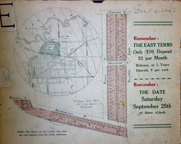
Plan - Subdivision Plan, H C Crouch, Old Golf Links Estate, 1930s
... Kew (Vic.) Old Golf Links Estate Annotations: "E" top left. "Golf Links" top right. Lots 73-76 ticked and listed as "6" pounds One part of a massive subdivision of the Old Golf Links Estate in North Kew of 80 allotments bordering Sutherland Avenue, Ramsay Avenue, Belford Road, Beresford Street and Coleman Avenue. ...The land in North Kew between the Outer Circle Railway and the River Yarra was released in sections. This release included 80 lots. Most of this area was released during the Depression years in the early 1930s.Subdivision plans are historically important documents used as evidence of the growth of suburbs in Australia. They frequently provide information about when the land was sold on which a built structure was subsequently constructed as well as evidence relating to surveyors and real estate and financial agents. The numerous subdivision plans in the Kew Historical Society's collection represent working documents, ranging from the initial sketches made in planning a subdivision to printed plans on which auctioneers or agents listed the prices for which individual lots were sold. In a number of cases, the reverse of a subdivision plan in the collection includes a photograph of a house that was also for sale by the agent. These photographs provide significant heritage information relating house design and decoration, fencing and household gardens.One part of a massive subdivision of the Old Golf Links Estate in North Kew of 80 allotments bordering Sutherland Avenue, Ramsay Avenue, Belford Road, Beresford Street and Coleman Avenue. Inset on the plan at the top left, the route of the Outer Circle Railway is clearly marked. The Kew Golf Links is identified in its current location. The land on which Greenacres Golf Club was to be constructed is at this time marked as ‘Recreation Ground’. The ‘new bridge’ over the Yarra at Burke Road is also marked on the inset map. The Plan identifies the surveyor (sic) H.C. Crouch BCE MVIS, 443 Little Collins St., Melbourne. The date of the subdivision auction sale in identified as Saturday September 25th at three o'clock.Annotations: "E" top left. "Golf Links" top right. Lots 73-76 ticked and listed as "6" poundssubdivisions -- kew (vic.), old golf links estate -
 Kew Historical Society Inc
Photograph - 8 roomed DF Brick Villa, Kew, J E Barnes, c.1920
... The brown card on which the photograph is mounted includes the following handwritten description, which may aid the identification of the house: "Kew, 3 minutes from tram, 8 roomed DF Brick Villa, tile roof including two attics, sleepout, bathroom, heater, E Light, Entrance Hall, double doors, leadlights, laundry, garden, lawns, land 75 x 170, 1975 pounds". ...He clearly also completed commercial jobs for local businesses, as is the case in this photograph of a house for a local real estate and financial agent. j. e. barnes, josiah earl barnes, j. earl banes - photographer architecture - federation style, houses - kew real estate photographs The brown card on which the photograph is mounted includes the following handwritten description, which may aid the identification of the house: "Kew, 3 minutes from tram, 8 roomed DF Brick Villa, tile roof including two attics, sleepout, bathroom, heater, E Light, Entrance Hall, double doors, leadlights, laundry, garden, lawns, land 75 x 170, 1975 pounds". ...Subdivision plans are historically important documents used as evidence of the growth of suburbs in Australia. They frequently provide information about when the land was sold on which a built structure was subsequently constructed as well as evidence relating to surveyors and real estate and financial agents. The numerous subdivision plans in the Kew Historical Society's collection represent working documents, ranging from the initial sketches made in planning a subdivision to printed plans on which auctioneers or agents listed the prices for which individual lots were sold. In a number of cases, the reverse of a subdivision plan in the collection includes a photograph of a house that was also for sale by the agent. These photographs provide significant heritage information relating house design and decoration, fencing and household gardens. The photograph is of additional aesthetic significance as it was photographed by J. E. Barnes. Josiah Earl Barnes is a nationally significant photographer. He was also the most important photographer to have worked in Kew. He was active as a photographer in the district from c.1906 until his death in 1921. Best known as 'the Embarkation Photographer' (see the Australian War Memorial collection), J. Earl Barnes was also the official photographer employed by the Borough (and later Town, then City) of Kew. He clearly also completed commercial jobs for local businesses, as is the case in this photograph of a house for a local real estate and financial agent.A photograph, mounted on board of a double fronted Federation-era brick villa in Kew, photographed for a local real estate agent and financier by J. E. Barnes of Kew. On the reverse of the photograph is a subdivision plan for the Normanby Estate, East Kew - 2016.0039.1. As can be seen from the image, there is a large tear on the surface of the photograph.The brown card on which the photograph is mounted includes the following handwritten description, which may aid the identification of the house: "Kew, 3 minutes from tram, 8 roomed DF Brick Villa, tile roof including two attics, sleepout, bathroom, heater, E Light, Entrance Hall, double doors, leadlights, laundry, garden, lawns, land 75 x 170, 1975 pounds". Also photographers inscription on mount, lower left: J. E. Barnes / Photo / Phone 1966 Haw. KEW.j. e. barnes, josiah earl barnes, j. earl banes - photographer, architecture - federation style, houses - kew, real estate photographs -
 Kew Historical Society Inc
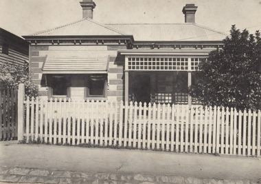
Photograph - W.B. Villa, Kew, c.1919
... KEW. Close tram. Fine View. / W.B. Villa Containing 8 Rooms. / Up-to-date Conveniences. EL Etc." Below - "Land 40 x 165. 615 pounds. ...KEW. Close tram. Fine View. / W.B. Villa Containing 8 Rooms. / Up-to-date Conveniences. EL Etc." Below - "Land 40 x 165. 615 pounds. ...The photograph offers significant information relating to late Victorian / Federation colour schemes and fencing.The block fronted villa has a corrugated iron roof and a flat projecting verandah, ornamented with a trellis design of timber. The front window features a timber shade, mounted on brackets. The treatment of the block-fronted panels shows that there is an attempt to highlight imitation quoining through use of a darker colour. The windows and door are also in this darker shade. The front fence and gate are made of wooden pickets. It is unlikely that the photograph was taken at the time of the villa's construction given the size of the shrub/tree in the front garden.Subdivision plans are historically important documents used as evidence of the growth of suburbs in Australia. They frequently provide information about when the land was sold on which a built structure was subsequently constructed as well as evidence relating to surveyors and real estate and financial agents. The numerous subdivision plans in the Kew Historical Society's collection represent working documents, ranging from the initial sketches made in planning a subdivision to printed plans on which auctioneers or agents listed the prices for which individual lots were sold. In a number of cases, the reverse of a subdivision plan in the collection includes a photograph of a house that was also for sale by the agent. These photographs provide significant heritage information relating house design and decoration, fencing and household gardens.A real estate photograph, mounted on brown card, showing a double fronted weatherboard villa, located in Kew, Victoria. On the reverse of the photograph is a subdivision plan for the Altyre Estate.Stamped on mount: Top - "KEW. Close tram. Fine View. / W.B. Villa Containing 8 Rooms. / Up-to-date Conveniences. EL Etc." Below - "Land 40 x 165. 615 pounds. Sold"houses - kew, real estate photographs -
 Kew Historical Society Inc
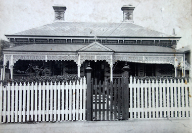
Photograph - Victorian Double-fronted Brock Villa, Cotham Road, c. 1919
... Kew. Central. Close tram. / Comfortable Brick Villa. / Containing 7 rooms / Modern conveniences: / Land 66 x 167. Sold 1100 pounds...Kew. Central. Close tram. / Comfortable Brick Villa. / Containing 7 rooms / Modern conveniences: / Land 66 x 167. Sold 1100 pounds ...The Kew Historical Society's map collection includes a substantial number of real estate subdivision plans, mainly of Kew but also of surrounding suburbs in Melbourne. Most of the subdivision plans date from the 1920s and 1930s when the districts old homes and local farmland were being split up to accommodate residential growth in the postwar period. These early plans were assembled by a local firm, Jas R Mather & McMillan, which had an office in Cotham Road. Many of the plans, and sometimes photos, were annotated by the agents.Subdivision plans are historically important documents used as evidence for the growth of suburbs in Australia. They frequently provide information about when the land was sold as well as evidence relating to surveyors and real estate and financial agents. The numerous subdivision plans in the Kew Historical Society's collection represent working documents, ranging from the initial sketches made in planning a subdivision to printed plans on which auctioneers or agents listed the prices for which individual lots were sold. In a number of cases, the reverse of a subdivision plan in the collection includes a photograph of a house that was also for sale by the agent. These photographs provide significant heritage information relating house design and decoration, fencing and household gardens.The photograph may also be aesthetically significant depending o the importance of the photographic atelier.Real estate photographs of a classic double-fronted late Victorian brick villa. It central location in Cotham Road, Kew enabled the selling agent to note its proximity to the tram. With seven rooms, all ‘modern conveniences’, and land of 66×167, the house was to be sold for £1100. The villa has a number of interesting features including a pattern within the slate roof as well as the use of polychrome brickwork under the eaves and on the façade. The intricacy of the cast iron lace is emphasised by the line of projecting wooden blocks above it. The picket gate is painted a different colour to the pickets of the fence. The house has a name (illegible) that is attached to the inset cast iron lace of the central projecting gable in the veranda. Stamped on mount: "Kew. Central. Close tram. / Comfortable Brick Villa. / Containing 7 rooms / Modern conveniences: / Land 66 x 167. Sold 1100 pounds:"houses - kew, victorian villas, real estate photographs, cotham road - kew -
![7 Roomed Brick [villa]; Modern Conveniences](/media/collectors/550653872162f11fb04854aa/items/59ec3da221ea690fdc4ba793/item-media/59ec3ee521ea690fdc4d0c37/item-fit-380x285.jpg?cb=6) Kew Historical Society Inc
Kew Historical Society IncPhotograph - 7 Roomed Brick [villa]; Modern Conveniences, 1920s
... Kew. 1 minute to tram. Good Position. / 7 roomed brick. Modern conveniences. / Land 60 x 135. 1100 pounds"...Kew. 1 minute to tram. Good Position. / 7 roomed brick. Modern conveniences. / Land 60 x 135. 1100 pounds" A professionally produced photograph for a local real estate agent, probably Jas. ...The Kew Historical Society's map collection includes a substantial number of real estate subdivision plans, mainly of Kew but also of surrounding suburbs in Melbourne. Most of the subdivision plans date from the 1920s and 1930s when the districts old homes and local farmland were being split up to accommodate residential growth in the postwar period. These early plans were assembled by a local firm, Jas R Mather & McMillan, which had an office in Cotham Road. Many of the plans, and sometimes photos, were annotated by the agents.Subdivision plans are historically important documents used as evidence for the growth of suburbs in Australia. They frequently provide information about when the land was sold as well as evidence relating to surveyors and real estate and financial agents. The numerous subdivision plans in the Kew Historical Society's collection represent working documents, ranging from the initial sketches made in planning a subdivision to printed plans on which auctioneers or agents listed the prices for which individual lots were sold. In a number of cases, the reverse of a subdivision plan in the collection includes a photograph of a house that was also for sale by the agent. These photographs provide significant heritage information relating house design and decoration, fencing and household gardens.The photograph may also be aesthetically significant depending on the importance of the photographic atelier.A professionally produced photograph for a local real estate agent, probably Jas. R. Mathers, Son & McMillan. The photograph is of a Federation-era bungalow, in Kew. The photo is on the reverse of a subdivision plan for the Normanby Heights Estate, Kew.The mount on which the photograph is placed includes: "Kew. 1 minute to tram. Good Position. / 7 roomed brick. Modern conveniences. / Land 60 x 135. 1100 pounds"real estate photographs, houses - kew, federation architecture -
 Kew Historical Society Inc
Leisure object, Child's Puzzle : Denmark Street Baby Health Centre, c.1950s
... In May 1939, the Railway Commissioners agreed to lease a site at the Kew Railway Station for a Baby Health Centre for a term of 21 years at 3 pounds per annum. ...In May 1939, the Railway Commissioners agreed to lease a site at the Kew Railway Station for a Baby Health Centre for a term of 21 years at 3 pounds per annum. ...In August, 1920, The Kew Town Council decided to establish a Baby Health Centre in Kew. The first Centre was opened in a room in the Town Hall in Walpole Street on 5 November 1920. In May 1939, the Railway Commissioners agreed to lease a site at the Kew Railway Station for a Baby Health Centre for a term of 21 years at 3 pounds per annum. A building, designed by Roland Chipperfield, was erected, and the Centre previously conducted at the Town Hall transferred there. This became known as the Denmark Street Baby Health Centre. (Cr. W.D. Vaughan, Kew’s Civic Century, W.D. Vaughan Pty Ltd., Kew, 1960, pp.96 & 97.)One of a pair of wooden puzzles used in the Denmark Street Baby Health Centre in Kew.denmark street baby health centre - kew (vic), baby health centres - kew (vic), games and puzzles -
 Kew Historical Society Inc
Photograph - Peel Street Health Centre : Official Opening, 1930
... Kew. It followed a lease of a house at 50 Willsmere Road. The Peel Street building was designed by Mr Chipperfield. Messrs McIntosh and Taylor were the successful tenderers, the price being 1,240 pounds. ...Kew. It followed a lease of a house at 50 Willsmere Road. The Peel Street building was designed by Mr Chipperfield. Messrs McIntosh and Taylor were the successful tenderers, the price being 1,240 pounds. ...The North Kew Centre was the third established at North Kew. It followed a lease of a house at 50 Willsmere Road. The Peel Street building was designed by Mr Chipperfield. Messrs McIntosh and Taylor were the successful tenderers, the price being 1,240 pounds. The North Kew Baby Health Centre was finally opened on 18 June 1930 in the presence of the mayor, councillors and citizens of Kew, and representatives of the Infant Welfare Council. A report in The Age of 19 June described the opening in detail as well as the features of the new Centre. These included: "The rooms ... filled with flowers, pink and mauve hydrangeas and native heath, and the walls are adorned, with a charming frieze, representing windmills, flocks and a fairy tale goose girl. On the walls are hygiene editions of the funniest of Belloc's "Cautionary Tales" revised as posters, Outside there is promise of a gay garden, and a lovely view of green fields sloping to a shining bend of the river." Early photographic record of the opening of an early baby health centre in Kew.[Badly damaged] black and white photograph of the opening of the North Kew Baby Health Centre in Peel Street. The photo is mounted on card, and shows mothers and their children on the veranda, and officials at right. The latter includes the Mayoress and probably Vera Scantlebury. All mothers wear hats as do most of the children. [When the photograph was presented to the Society in 1979, it was described in the first Acquisitions Register as framed. Some time after that it was removed from its frame and badly broken. A separate photocopy of the original photograph is also held in the collection.]Earliest inscription: "Peel Street Health Centre / Official Opening 1930 / donated by Sr Costello and Sr Bewish [sic] 1979 / Copy purchased by ..... for Centre". Old Accession number in Texta: "KH-133 Kew Historical Society". Separate later label: "Opening North Kew Baby Health centre 1930". north kew baby health centre, peel street (kew), baby health centres - kew (vic) -
 Kew Historical Society Inc
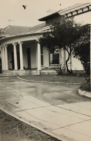
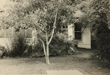
Photograph, Glendonald School for the Deaf, Marshall Avenue, 1960-1970
... Glendonald was a significant mansion in Kew (now demolished) built for the industrialist and manufacturer Donald Leslie in 1886. The school was purchased by the Victorian Department of Education on 29 November 1950 for the sum of 16,500 pounds. glendonald - marshall avenue - kew (vic) education - deaf children - victoria "The old school for the deaf at 17 Marshall Ave for children from the age of six years to ten years old, then they would go to 25 Marshall Ave to finish their schooling leaving age 16 years old." ...Glendonald School for Deaf Children was run by the Victorian Education Department. It provided education and some residential services for deaf children. The school was situated in Marshall Avenue, Kew and operated from 1951–91. Deaf children whose families lived too far to travel daily were housed in a grand Victorian mansion in Belmont Avenue, Kew, the John Cannon Hostel. The school and hostel also accommodated a small number of wards of the state. Source: Glendonald School for Deaf Children (1951–91); https://www.findingrecords.dhhs.vic.gov.au/collectionresultspage/GlendonaldSchoolforDeafChildren; Accessed 05/09/2018.Glendonald was a significant mansion in Kew (now demolished) built for the industrialist and manufacturer Donald Leslie in 1886. The school was purchased by the Victorian Department of Education on 29 November 1950 for the sum of 16,500 pounds.Photograph of the front garden of Glendonald taken from Marshall Avenue."The old school for the deaf at 17 Marshall Ave for children from the age of six years to ten years old, then they would go to 25 Marshall Ave to finish their schooling leaving age 16 years old."glendonald - marshall avenue - kew (vic), education - deaf children - victoria -
 Kew Historical Society Inc
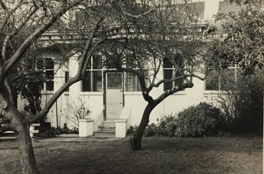
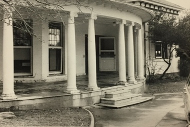
Photograph, Glendonald School for the Deaf, Marshall Avenue, 1955-1965
... Glendonald was a significant mansion in Kew (now demolished) built for the industrialist and manufacturer Donald Leslie in 1886. The school was purchased by the Victorian Department of Education on 29 November 1950 for the sum of 16,500 pounds. glendonald - marshall avenue - kew (vic) education - deaf children - victoria The old school for the deaf at 17 Marshall Ave for children from the age of six years to ten years old, then they would go to 25 Marshall Ave to finish their schooling leaving age 16 years old. ...Glendonald School for Deaf Children was run by the Victorian Education Department. It provided education and some residential services for deaf children. The school was situated in Marshall Avenue, Kew and operated from 1951–91. Deaf children whose families lived too far to travel daily were housed in a grand Victorian mansion in Belmont Avenue, Kew, the John Cannon Hostel. The school and hostel also accommodated a small number of wards of the state. (Source: Glendonald School for Deaf Children 1951–91.)Glendonald was a significant mansion in Kew (now demolished) built for the industrialist and manufacturer Donald Leslie in 1886. The school was purchased by the Victorian Department of Education on 29 November 1950 for the sum of 16,500 pounds.Portico - entrance - of Glendonald taken from Marshall Avenue.The old school for the deaf at 17 Marshall Ave for children from the age of six years to ten years old, then they would go to 25 Marshall Ave to finish their schooling leaving age 16 years old. glendonald - marshall avenue - kew (vic), education - deaf children - victoria -
 Kew Historical Society Inc
Photograph, Glendonald School for the Deaf, Marshall Avenue, 1955-1965
... (Source: Glendonald School for Deaf Children 1951–91) Glendonald was a significant mansion in Kew (now demolished) built for the industrialist and manufacturer Donald Leslie in 1886. The school was purchased by the Victorian Department of Education on 29 November 1950 for the sum of 16,500 pounds. glendonald - marshall avenue - kew (vic) education - deaf children - victoria Reverse: "The old school for the deaf at 17 Marshall Ave for children from the age of six years to ten years old, then they would go to 25 Marshall Ave to finish their schooling leaving age 16 years old." ...Glendonald School for Deaf Children was run by the Victorian Education Department. It provided education and some residential services for deaf children. The school was situated in Marshall Avenue, Kew and operated from 1951–91. Deaf children whose families lived too far to travel daily were housed in a grand Victorian mansion in Belmont Avenue, Kew, the John Cannon Hostel. The school and hostel also accommodated a small number of wards of the state. (Source: Glendonald School for Deaf Children 1951–91)Glendonald was a significant mansion in Kew (now demolished) built for the industrialist and manufacturer Donald Leslie in 1886. The school was purchased by the Victorian Department of Education on 29 November 1950 for the sum of 16,500 pounds.Rear view (sic) of Glendonald, Marshall Avenue (Kew).Reverse: "The old school for the deaf at 17 Marshall Ave for children from the age of six years to ten years old, then they would go to 25 Marshall Ave to finish their schooling leaving age 16 years old."glendonald - marshall avenue - kew (vic), education - deaf children - victoria -
 Kew Historical Society Inc
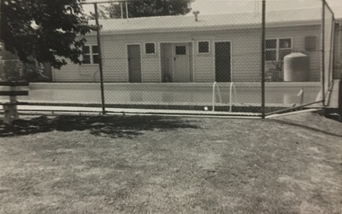
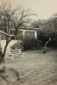
Photograph, Glendonald School for the Deaf, Marshall Avenue, 1955-1965
... (Source: Glendonald School for Deaf Children 1951–91) Glendonald was a significant mansion in Kew (now demolished) built for the industrialist and manufacturer Donald Leslie in 1886. The school was purchased by the Victorian Department of Education on 29 November 1950 for the sum of 16,500 pounds. glendonald - marshall avenue - kew (vic) education - deaf children - victoria The old school for the deaf at 17 Marshall Ave for children from the age of six years to ten years old, then they would go to 25 Marshall Ave to finish their schooling leaving age 16 years old. ...Glendonald School for Deaf Children was run by the Victorian Education Department. It provided education and some residential services for deaf children. The school was situated in Marshall Avenue, Kew and operated from 1951–91. Deaf children whose families lived too far to travel daily were housed in a grand Victorian mansion in Belmont Avenue, Kew, the John Cannon Hostel. The school and hostel also accommodated a small number of wards of the state. (Source: Glendonald School for Deaf Children 1951–91)Glendonald was a significant mansion in Kew (now demolished) built for the industrialist and manufacturer Donald Leslie in 1886. The school was purchased by the Victorian Department of Education on 29 November 1950 for the sum of 16,500 pounds.Swimming Pool, Glendonald, Marshall Avenue (Kew).The old school for the deaf at 17 Marshall Ave for children from the age of six years to ten years old, then they would go to 25 Marshall Ave to finish their schooling leaving age 16 years old. glendonald - marshall avenue - kew (vic), education - deaf children - victoria -
 Kew Historical Society Inc
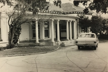
Photograph, Glendonald School for the Deaf, Marshall Avenue, 1955-1965
... (Source: Glendonald School for Deaf Children 1951–91) Glendonald was a significant mansion in Kew (now demolished) built for the industrialist and manufacturer Donald Leslie in 1886. The school was purchased by the Victorian Department of Education on 29 November 1950 for the sum of 16,500 pounds. glendonald - marshall avenue - kew (vic) education - deaf children - victoria The old school for the deaf at 17 Marshall Ave for children from the age of six years to ten years old, then they would go to 25 Marshall Ave to finish their schooling leaving age 16 years old. ...Glendonald School for Deaf Children was run by the Victorian Education Department. It provided education and some residential services for deaf children. The school was situated in Marshall Avenue, Kew and operated from 1951–91. Deaf children whose families lived too far to travel daily were housed in a grand Victorian mansion in Belmont Avenue, Kew, the John Cannon Hostel. The school and hostel also accommodated a small number of wards of the state. (Source: Glendonald School for Deaf Children 1951–91)Glendonald was a significant mansion in Kew (now demolished) built for the industrialist and manufacturer Donald Leslie in 1886. The school was purchased by the Victorian Department of Education on 29 November 1950 for the sum of 16,500 pounds.Front entrance, Glendonald, Marshall Avenue (Kew).The old school for the deaf at 17 Marshall Ave for children from the age of six years to ten years old, then they would go to 25 Marshall Ave to finish their schooling leaving age 16 years old. glendonald - marshall avenue - kew (vic), education - deaf children - victoria -
 Kew Historical Society Inc
Photograph, Glendonald School for the Deaf, Marshall Avenue, 1955-1965
... (Source: Glendonald School for Deaf Children 1951–91) Glendonald was a significant mansion in Kew (now demolished) built for the industrialist and manufacturer Donald Leslie in 1886. The school was purchased by the Victorian Department of Education on 29 November 1950 for the sum of 16,500 pounds. glendonald - marshall avenue - kew (vic) education - deaf children - victoria The old school for the deaf at 17 Marshall Ave for children from the age of six years to ten years old, then they would go to 25 Marshall Ave to finish their schooling leaving age 16 years old. ...Glendonald School for Deaf Children was run by the Victorian Education Department. It provided education and some residential services for deaf children. The school was situated in Marshall Avenue, Kew and operated from 1951–91. Deaf children whose families lived too far to travel daily were housed in a grand Victorian mansion in Belmont Avenue, Kew, the John Cannon Hostel. The school and hostel also accommodated a small number of wards of the state. (Source: Glendonald School for Deaf Children 1951–91)Glendonald was a significant mansion in Kew (now demolished) built for the industrialist and manufacturer Donald Leslie in 1886. The school was purchased by the Victorian Department of Education on 29 November 1950 for the sum of 16,500 pounds.Trampoline in the garden of Glendonald, Marshall Avenue (Kew).The old school for the deaf at 17 Marshall Ave for children from the age of six years to ten years old, then they would go to 25 Marshall Ave to finish their schooling leaving age 16 years old. glendonald - marshall avenue - kew (vic), education - deaf children - victoria -
 Kew Historical Society Inc
Photograph, Glendonald School for the Deaf, Marshall Avenue, 1955-1965
... (Source: Glendonald School for Deaf Children 1951–91) Glendonald was a significant mansion in Kew (now demolished) built for the industrialist and manufacturer Donald Leslie in 1886. The school was purchased by the Victorian Department of Education on 29 November 1950 for the sum of 16,500 pounds. glendonald - marshall avenue - kew (vic) education - deaf children - victoria The old school for the deaf at 17 Marshall Ave for children from the age of six years to ten years old, then they would go to 25 Marshall Ave to finish their schooling leaving age 16 years old. ...Glendonald School for Deaf Children was run by the Victorian Education Department. It provided education and some residential services for deaf children. The school was situated in Marshall Avenue, Kew and operated from 1951–91. Deaf children whose families lived too far to travel daily were housed in a grand Victorian mansion in Belmont Avenue, Kew, the John Cannon Hostel. The school and hostel also accommodated a small number of wards of the state. (Source: Glendonald School for Deaf Children 1951–91)Glendonald was a significant mansion in Kew (now demolished) built for the industrialist and manufacturer Donald Leslie in 1886. The school was purchased by the Victorian Department of Education on 29 November 1950 for the sum of 16,500 pounds.Front entrance, Glendonald, Marshall Avenue (Kew).The old school for the deaf at 17 Marshall Ave for children from the age of six years to ten years old, then they would go to 25 Marshall Ave to finish their schooling leaving age 16 years old. glendonald - marshall avenue - kew (vic), education - deaf children - victoria -
 Kew Historical Society Inc
Photograph, Glendonald School for the Deaf, Marshall Avenue, 1955-1965
... (Source: Glendonald School for Deaf Children 1951–91) Glendonald was a significant mansion in Kew (now demolished) built for the industrialist and manufacturer Donald Leslie in 1886. The school was purchased by the Victorian Department of Education on 29 November 1950 for the sum of 16,500 pounds. glendonald - marshall avenue - kew (vic) education - deaf children - victoria The old school for the deaf at 17 Marshall Ave for children from the age of six years to ten years old, then they would go to 25 Marshall Ave to finish their schooling leaving age 16 years old. ...Glendonald School for Deaf Children was run by the Victorian Education Department. It provided education and some residential services for deaf children. The school was situated in Marshall Avenue, Kew and operated from 1951–91. Deaf children whose families lived too far to travel daily were housed in a grand Victorian mansion in Belmont Avenue, Kew, the John Cannon Hostel. The school and hostel also accommodated a small number of wards of the state. (Source: Glendonald School for Deaf Children 1951–91)Glendonald was a significant mansion in Kew (now demolished) built for the industrialist and manufacturer Donald Leslie in 1886. The school was purchased by the Victorian Department of Education on 29 November 1950 for the sum of 16,500 pounds.Garden, Glendonald, Marshall Avenue (Kew).The old school for the deaf at 17 Marshall Ave for children from the age of six years to ten years old, then they would go to 25 Marshall Ave to finish their schooling leaving age 16 years old. glendonald - marshall avenue - kew (vic), education - deaf children - victoria -
 Kew Historical Society Inc
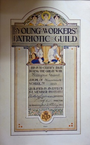
Certificate, Education Department (Victoria), Young Workers Patriotic Guild, 1917
... pound ‘by personal productive effort’ received a certificate. The money was used for the war effort. The Government Minister, Harry Sutherland Wightman Lawson, and the Director of Schools, Frank Tate, signed each certificate. Lawson (later Sir Henry) was the Attorney General in the Government of Alexander Peacock between 1915-17. He was to become Premier of Victoria in 1918. This is one of three Young Workers Patriotic Guild certificates in the Kew...Kew Historical Society Inc Kew Court House 188 High Street Kew melbourne The Young Workers’ Patriotic Guild was formed in Victorian schools in 1916. Each child who raised one pound ‘by personal productive effort’ received a certificate. ...The Young Workers’ Patriotic Guild was formed in Victorian schools in 1916. Each child who raised one pound ‘by personal productive effort’ received a certificate. The money was used for the war effort. The Government Minister, Harry Sutherland Wightman Lawson, and the Director of Schools, Frank Tate, signed each certificate. Lawson (later Sir Henry) was the Attorney General in the Government of Alexander Peacock between 1915-17. He was to become Premier of Victoria in 1918. This is one of three Young Workers Patriotic Guild certificates in the Kew Collection, two from the First World War and one from the Second World War. The framed certificate was donated to the Kew Historical Society by past member, Eva Grant. The certificate was awarded to her sister in 1917.Young Workers’ Patriotic Guild commemorative certificate. The certificate was awarded to Marjorie Grant, a pupil of the Brunswick School No.1213. Awarded to 'Marjorie Grant" a pupil of "Brunswick" school No. "1213"young workers patriotic guild, first world war, ww1, eva grant -
 Kew Historical Society Inc
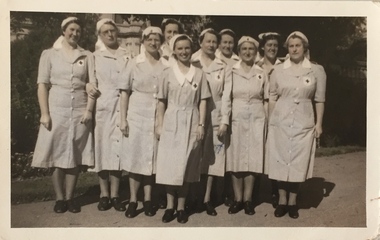
Photograph, Lillias Jerram & other V.A.D. nurses, 1939-46
... Kew) Detachment in 1937. Commandant in 1944. Miss Jerram did voluntary duty in casualty and wards at St Vincent's Hospital regularly for 6 years. Also duty at the Eye and Ear Hospital and A.R.P. Duty. Helped No.323 Detachment to raise funds amounting to 400 pounds...Kew) Detachment in 1937. Commandant in 1944. Miss Jerram did voluntary duty in casualty and wards at St Vincent's Hospital regularly for 6 years. Also duty at the Eye and Ear Hospital and A.R.P. Duty. Helped No.323 Detachment to raise funds amounting to 400 pounds ...In the collection of the Kew RSL (Cotham Road) there is a framed original certificate with information about Lillias Jerram. It includes the following information: Miss Lillias May JERRAM Commandant No. 323 Detachment, Victoria [Citation] Loyal and able leadership and service during World War II Service: Joined No.323 (Kew) Detachment in 1937. Commandant in 1944. Miss Jerram did voluntary duty in casualty and wards at St Vincent's Hospital regularly for 6 years. Also duty at the Eye and Ear Hospital and A.R.P. Duty. Helped No.323 Detachment to raise funds amounting to 400 pounds for St. John Theatre at 115th A.G.H., Heidelberg. Blood donor. [Courtesy: John Torpey representing the Kew RSL]Group portrait of Voluntary Aid Detachment (V.A.D.) nurses including Lillias Jerram who was a member of this group during 1939-46. The photograph was given at the same time as the embroidered V.A.D. tablecloth which also includes Miss Jerram's name (see 2002.0003)Inscription on reverse in inl: "Miss Lillias Jerram X. / V.A.D. Corp / 1939-46".voluntary aid detachment (kew branch), lillias jerram -
 Kew Historical Society Inc
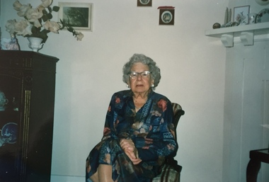
Photograph, Miss Lillias Jerram, aged 89, 1989
... Kew) Detachment in 1937. Commandant in 1944. Miss Jerram did voluntary duty in casualty and wards at St Vincent's Hospital regularly for 6 years. Also duty at the Eye and Ear Hospital and A.R.P. Duty. Helped No.323 Detachment to raise funds amounting to 400 pounds...Kew) Detachment in 1937. Commandant in 1944. Miss Jerram did voluntary duty in casualty and wards at St Vincent's Hospital regularly for 6 years. Also duty at the Eye and Ear Hospital and A.R.P. Duty. Helped No.323 Detachment to raise funds amounting to 400 pounds ...In the collection of the Kew RSL (Cotham Road) there is a framed original certificate with information about Lillias Jerram. It includes the following information: Miss Lillias May JERRAM Commandant No. 323 Detachment, Victoria [Citation] Loyal and able leadership and service during World War II Service: Joined No.323 (Kew) Detachment in 1937. Commandant in 1944. Miss Jerram did voluntary duty in casualty and wards at St Vincent's Hospital regularly for 6 years. Also duty at the Eye and Ear Hospital and A.R.P. Duty. Helped No.323 Detachment to raise funds amounting to 400 pounds for St. John Theatre at 115th A.G.H., Heidelberg. Blood donor. [Courtesy: John Torpey representing the Kew RSL]Miss Lillias Jerram in 1989, taken on her 89th birthday. Miss Jerram who lived at 37 Rowland Street, Kew was, during the Second World War, a member of the Kew Voluntary Aid Detachment (V.A.D.)Inscription on reverse in ink: "27.12.89. / Miss Lillias Jerram / 37 Rowland Street Kew 31 / (Taken on her 89th birthday)."lillias jerram, voluntary aid detachment (kew branch), 37 rowland street (kew) -
 Kew Historical Society Inc
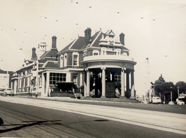
Photograph, J E & B L Rogers, Kew Post Office, 1967
... "1967 / Kew Post Office / Commissioned in 1887; completed 1888 at a cost of 10,000 [pounds]. ...Together it forms the largest privately-donated collection within the archives of the Kew Historical Society. kew post office public buildings -- kew (vic.) "1967 / Kew Post Office / Commissioned in 1887; completed 1888 at a cost of 10,000 [pounds]. ...This work forms part of the collection assembled by the historian Dorothy Rogers, that was donated to the Kew Historical Society by her son John Rogers in 2015. The manuscripts, photographs, maps, and documents were sourced by her from both family and local collections or produced as references for her print publications. Many were directly used by Rogers in writing ‘Lovely Old Homes of Kew’ (1961) and 'A History of Kew' (1973), or the numerous articles on local history that she produced for suburban newspapers. Most of the photographs in the collection include detailed annotations in her hand.The Rogers Collection provides a comprehensive insight into the working habits of a historian in the 1960s and 1970s. Together it forms the largest privately-donated collection within the archives of the Kew Historical Society.Small, black and white photo of Kew Post Office in 1967."1967 / Kew Post Office / Commissioned in 1887; completed 1888 at a cost of 10,000 [pounds]. Court House is seen at extreme left. (See other picture for Police Station & residence)."kew post office, public buildings -- kew (vic.) -
 Kew Historical Society Inc
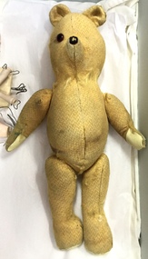
Leisure object, Teddy Bear, 1930-1955
... In May 1939, the Railway Commissioners agreed to lease a site at the Kew Railway Station for a Baby Health Centre for a term of 21 years at 3 pounds per annum. ...In May 1939, the Railway Commissioners agreed to lease a site at the Kew Railway Station for a Baby Health Centre for a term of 21 years at 3 pounds per annum. ...In August, 1920, The Kew Town Council decided to establish a Baby Health Centre in Kew. The first Centre was opened in a room in the Town Hall in Walpole Street on 5 November 1920. In May 1939, the Railway Commissioners agreed to lease a site at the Kew Railway Station for a Baby Health Centre for a term of 21 years at 3 pounds per annum. A building, designed by Roland Chipperfield, was erected, and the Centre previously conducted at the Town Hall transferred there. This became known as the Denmark Street Baby Health Centre. (Cr. W.D. Vaughan, Kew’s Civic Century, W.D. Vaughan Pty Ltd., Kew, 1960, pp.96 & 97.)Small teddy bear with only one eye remaining and with a number of repairs. The bear was used by children at the Denmark Street Baby Health Centre in Kew.toys - teddy bears, denmark street baby health centre - kew (vic) -
 Kew Historical Society Inc
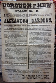
Document, Borough of Kew, Borough of Kew By-Law No.45 : Alexandra Gardens, 1908
... The financial penalty for breaching the By-Law was determined as “…not exceeding Ten pounds and not less than Five shillings”. This original copy of the By-Law was donated to the Kew Historical Society by the City of Kew....The financial penalty for breaching the By-Law was determined as “…not exceeding Ten pounds and not less than Five shillings”. This original copy of the By-Law was donated to the Kew Historical Society by the City of Kew. ...The ‘Alexandra Gardens’ in Cotham Road were designed and laid out by George and Thomas Pockett. The Governor of Victoria officially opened them in 1908. A report of the opening stated that “…the gardens have been laid out in large sloping lawns, divided by wide graveled paths, and dotted with tastefully arranged flower beds, which are now bright with autumn bloom”. The massed beds of shrubs and flowers included beds of chrysanthemums, a specialty of George Pockett, the Garden’s first curator. A large rotunda was constructed in 1910 to mark the Jubilee of Kew. A plaque memorialising the contribution of George Pockett, was attached to the original rotunda after his death in 1922. By 1911, electric lighting was installed to allow the public to access the Gardens, and the concerts that were held within them on summer nights. The Gardens were later to include the Jubilee Fountain, moved from the front of the Kew Post Office in 1925. The Kew Council commissioned the substantial bluestone entrance gates in 1933.The Kew Historical Society is fortunate that the City Engineer, Mr Poulter, donated a number of items held by the City of Kew to the Society for safekeeping, rather than identifying them for destruction. The most significant items donated included old maps, including those issued by the Board of Works. Other items included photographs of public works undertaken by the Department. The By-laws are part of that donation and tell us lots about the social values of the period.The Mayor, Councillors and Burgesses of the Borough of Kew published By-Law No.45 in 1908 to regulate the “Conduct of Persons whilst at or Within the Gardens known as the Alexandra Gardens”. The By-Law also set a charge for “Persons Using or Entering in or upon the said Gardens”. The 17 by-laws included predictable prohibitions on expectorating, using indecent language, interfering with the floral displays, or indeed with the caretaker gardeners. Other acts prohibited included a warning that “Children under the age of ten years not being under the control of some competent person may be removed from said gardens”. The Alexandra Gardens were at one stage surrounded by a picket fence. This might explain the prohibition on climbing upon or getting through over or under any fence at or within the gardens. The financial penalty for breaching the By-Law was determined as “…not exceeding Ten pounds and not less than Five shillings”. This original copy of the By-Law was donated to the Kew Historical Society by the City of Kew.alexandra gardens (cotham road, kew), city of kew -
 Kew Historical Society Inc
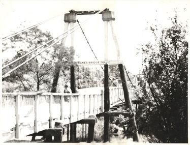
Photograph - Photograph (copy), Kanes Bridge, Studley Park, 195-1955
... In 1928 a footbridge was erected to link Kew with the public golf course across the Yarra. The total cost of construction came to 250 pounds and the bridge became known as Kane's Bridge. ...Kew Historical Society Inc Kew Court House 188 High Street Kew melbourne In 1928 a footbridge was erected to link Kew with the public golf course across the Yarra. The total cost of construction came to 250 pounds and the bridge became known as Kane's Bridge. ...In 1928 a footbridge was erected to link Kew with the public golf course across the Yarra. The total cost of construction came to 250 pounds and the bridge became known as Kane's Bridge. During the 1934 floods the bridge was washed downstream, and was subsequently rebuilt. The present form of the bridge resembles the earlier bridge which crossed from the Yarra Bend Asylum to Kew, further upstream. (VHD)This work forms part of the collection assembled by the historian Dorothy Rogers, that was donated to the Kew Historical Society by her son John Rogers in 2015. The manuscripts, photographs, maps, and documents were sourced by her from both family and local collections or produced as references for her print publications. Many were directly used by Rogers in writing ‘Lovely Old Homes of Kew’ (1961) and 'A History of Kew' (1973), or the numerous articles on local history that she produced for suburban newspapers. Most of the photographs in the collection include detailed annotations in her hand. The Rogers Collection provides a comprehensive insight into the working habits of a historian in the 1960s and 1970s. Together it forms the largest privately-donated collection within the archives of the Kew Historical Society.A photographic copy of an older photograph of Kanes Bridge."Kanes Bridge"kanes bridge, yarra river, bridges - kew (vic.) -
 Kew Historical Society Inc
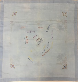
Decorative object - Volunteer Aid Detachment (Kew) Souvenir Signature Cloth, c.1948
... Kew) Detachment in 1937. Commandant in 1944. Miss Jerram did voluntary duty in casualty and wards at St Vincent's Hospital regularly for 6 years. Also duty at the Eye and Ear Hospital and A.R.P. Duty. Helped No.323 Detachment to raise funds amounting to 400 pounds...Kew) Detachment in 1937. Commandant in 1944. Miss Jerram did voluntary duty in casualty and wards at St Vincent's Hospital regularly for 6 years. Also duty at the Eye and Ear Hospital and A.R.P. Duty. Helped No.323 Detachment to raise funds amounting to 400 pounds ...In the collection of the Kew RSL (Cotham Road) there is a framed original certificate with information about Lillias Jerram. It includes the following information: Miss Lillias May JERRAM Commandant No. 323 Detachment, Victoria [Citation] Loyal and able leadership and service during World War II Service: Joined No.323 (Kew) Detachment in 1937. Commandant in 1944. Miss Jerram did voluntary duty in casualty and wards at St Vincent's Hospital regularly for 6 years. Also duty at the Eye and Ear Hospital and A.R.P. Duty. Helped No.323 Detachment to raise funds amounting to 400 pounds for St. John Theatre at 115th A.G.H., Heidelberg. Blood donor. [Courtesy: John Torpey representing the Kew RSL]Women's contribution-utions to the war effort both in 1924-18 and again in 1939-45 were significant. Voluntary Aid Detachments. The primary role of a Voluntary Aid Detachment (VAD) member was that of nursing orderly in hospitals, carrying out menial but essential tasks - scrubbing floors, sweeping, dusting and cleaning bathrooms and other areas, dealing with bedpans, and washing patients. They were not employed in military hospitals, except as ward and pantry maids; rather, they worked in Red Cross convalescent and rest homes, canteens, and on troop trains.Small blue muslin tablecloth used at V.A.D. (Voluntray Aid Detatchment) meetings in Kew and embroidered with the names of notable members and office bearers. The date range provided in the embroidered names is 1918-1948.Signed with initials of members and the dates of their participation in the V.A.D.voluntary aid detachment (kew branch), signature table cloths, lilies may jerram