Showing 32 items matching "lease holding"
-
 Bendigo Historical Society Inc.
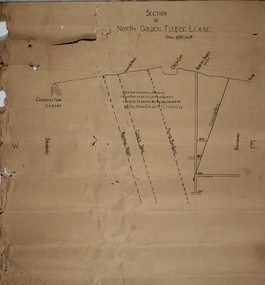
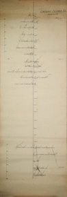
Plan - North Golden Fleece Lease, unknown
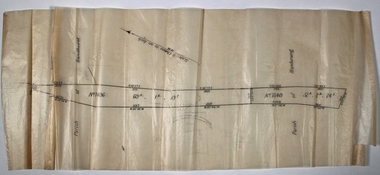
... ...lease holding...North Golden Fleece Gold Mine gold mining Bendigo lease holding Albert Gold Mine Ramrod Reef Comet Reef Stafford Reef and Frying Pan Reef Map drawn on heavy paper, titled 'Section of North Golden Fleece lease'. ...Map drawn on heavy paper, titled 'Section of North Golden Fleece lease'. Scale 80 ft to 1 inch. Written on plan in black print: 'This belt of country contains large bodies of auriferous quartz and at present is being operated on by the New Golden Fleece Company'. Reef lines marked on plan: Ramrod Reef, Comet Reef, Stafford Reef and Frying Pan Reef. The water race, Albert shaft and open cut are marked at the surface level. This plan is part of the Margaret Roberts Collection. north golden fleece gold mine, gold mining, bendigo, lease holding, albert gold mine, ramrod reef, comet reef, stafford reef and frying pan reef -
 Bendigo Historical Society Inc.
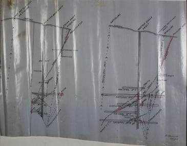
Map - Wattle Gully and Chewton main shafts
... ...lease holding...Margaret Roberts gold Chewton lease holding shaft Wattle Gully Cross section plan drawn on waxed paper. ...Cross section plan drawn on waxed paper. Notation on plan: Chewton Main shaft, Crown shaft, Wattle Gully shaft. Signature on plan: 'W. Edwards, 20.7.45.' Plan forms part of the Margaret Roberts Collection of mining records. margaret roberts, gold, chewton, lease holding, shaft, wattle gully -
 Bendigo Historical Society Inc.
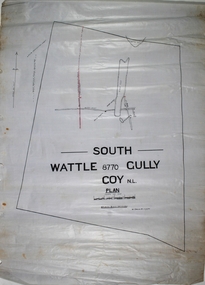
Map - South Wattle Gully Mine Chewton
... ...lease holding...Margaret Roberts gold South Wattle Gully Chewton lease holding Hand drawn map of South Wattle Gully lease with mine working indicated on map. ...The New Prince of Wales Mine was located Eaglehawk, nearest intersection Hopkins Road and Williams Road. The Old Prince of Wales Mine was nearby. Hand drawn map of South Wattle Gully lease with mine working indicated on map. Written on map: 'Places and reports, South Wattle Gully, W. Edwards, July 1945' Plan forms part of the Margaret Roberts Collection of mining records. margaret roberts, gold, south wattle gully, chewton, lease holding -
 Bendigo Historical Society Inc.
Map - Red Jacket Gully, Eaglehawk
... Hand drawn map of Red Jacket Gully, Eaglehawk, showing lease holdings. Scale 8chs to an inch, written on map. ...Red Jacket Gully drawn across lease holdings. Plan forms part of the Margaret Roberts Collection. ...Hand drawn map of Red Jacket Gully, Eaglehawk, showing lease holdings. Scale 8chs to an inch, written on map. Red Jacket Gully drawn across lease holdings. Plan forms part of the Margaret Roberts Collection.gold mining, gold, red jacket gully, eaglehawk -
 Bendigo Historical Society Inc.
Map - Mandurang and district Parish Map
... Waxed paper, black text map showing lease holdings numbers 7496 and 7540, with areas noted. ...gold mining gold Mandurang parish map Waxed paper, black text map showing lease holdings numbers 7496 and 7540, with areas noted. ...Waxed paper, black text map showing lease holdings numbers 7496 and 7540, with areas noted. Parish of Sandhurst written on top of map; Parish of Mandurang on bottom. Plan forms part of the Margaret Roberts Collection.gold mining, gold, mandurang, parish map -
 Bendigo Historical Society Inc.
Document - BENDIGO GOLD MINING PLAN OF LEASES, CENTRAL AREA
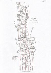
... One page document with a diagram showing reef lines and lease holdings in the central area of the Bendigo Goldfield. ...History House 11 Mackenzie Street Bendigo goldfields BENDIGO Mining lease holdings and reef lines One page document with a diagram showing reef lines and lease holdings in the central area of the Bendigo Goldfield. ...One page document with a diagram showing reef lines and lease holdings in the central area of the Bendigo Goldfield. Reef lines shown are Sheepshead Line, Deborah Line, Garden Gully Line, Paddy's Gully Line, Hustlers Line. Sourced from Bendigo Goldfields Library, Central area. CD Rom 622.3422 BENbendigo, mining, lease holdings and reef lines -
 Bendigo Historical Society Inc.
Plan - United Ulster Company, 9.11.45
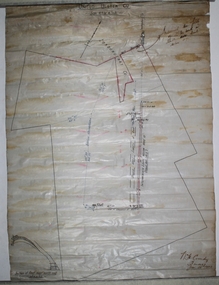
... Plan of lease holding drawn on off white paper, black ink. ...Quarry Hill Plan of lease holding drawn on off white paper, black ink. ...The Ulster United Gold Mine was located off Honeybone Street, Quarry Hill.Plan of lease holding drawn on off white paper, black ink. Written on top of plan: United Ulster Co.; on bottom right: W.H. Cundy Bendigo 29th January 1902. Hand drawn on bottom left of plan 'reef near north end. 10 ft to 1 inch'. Plan forms part of the Margaret Roberts Collection of mining records. bendigo, margaret roberts, gold, shaft, longitudinal section, ulster united co., quarry hill -
 Bendigo Historical Society Inc.
Document - MCCOLL, RANKIN AND STANISTREET COLLECTION: INDENTURE, GOLD MINING LEASE CROWN AND RONALD ALEXANDER RANKIN, BENDIGO, 24th June 1941
... ( Golden Gully area) Dams indicated on lease holdings. Other lease holdings: 1675 T.L.9858, 10990, 11013, 11062, 11165, 11063 (void) 1172 W.R. ...Belle Vue Road , Adam Street and Griston Street shown on map. ( Golden Gully area) Dams indicated on lease holdings. Other lease holdings: 1675 T.L.9858, 10990, 11013, 11062, 11165, 11063 (void) 1172 W.R. ...6 page document, Gold Mining Lease 11166, plus map. Indenture between Crown (King George VI) and Ronald Alexander Rankin of Bendigo, dated 24th June, 1941. Map No. 11166 Bendigo, Mining District of Bendigo, Parish of Sandhurst, County of Bendigo. Map shows lease 11166 marked in yellow with shaft, ore bins and tramway marked. Belle Vue Road , Adam Street and Griston Street shown on map. ( Golden Gully area) Dams indicated on lease holdings. Other lease holdings: 1675 T.L.9858, 10990, 11013, 11062, 11165, 11063 (void) 1172 W.R. (dam thereon) 9882 (void). Some residential lots marked along Belle Vue Road, and Adam Street. On bottom of map 21.8.41 in pencil. On last page of document : North Deborah Mining Company now the proprietor of the within described estate by transfer registered on 11th November 1914.bendigo, mining, north deborah lease, belle vue road, adams street, griston street, golden gully, ronald alexander rankin, north deborah mine. -
 Bendigo Historical Society Inc.
Plan - Confidence Extended Co, Unknown
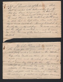
... CONFIDENCE EXTENDED This company, as will be soon by the plan, has a large lease holding on the extension of the line. The main shaft, which is in a fairly central position, is down about 2350 ft., while the lowest level at the N. shaft is at 1403ft. ...CONFIDENCE EXTENDED This company, as will be soon by the plan, has a large lease holding on the extension of the line. The main shaft, which is in a fairly central position, is down about 2350 ft., while the lowest level at the N. shaft is at 1403ft. ...The Confidence Extended Gold Mine was located near the corner of Taylor Street and Upper California Road, Long Gully. CONFIDENCE EXTENDED This company, as will be soon by the plan, has a large lease holding on the extension of the line. The main shaft, which is in a fairly central position, is down about 2350 ft., while the lowest level at the N. shaft is at 1403ft. After making- allowances for the northerly pitch of the country, it is calculated that the main shaft would require to be deepened about 600ft. in order to pick lip the continuation of the reef being opened up successfully in the "Windmill Hill mine. 'Bendigo Advertiser' 7th May 1909.Printed in black text on top of plan: 'Confidence Extended Co'. Handwritten name inscribed: 'N.Cundy, 8.2.10'. Transverse section of mine shaft, annotated with geological features and depths. Plan forms part of the Margaret Roberts Collection.gold mining, gold, bendigo, transverse section, confidence extended gold mine -
 Bendigo Historical Society Inc.
Document - MCCOLL, RANKIN AND STANISTREET COLLECTION: INDENTURE GOLD MINING LEASE 11012 CROWN AND NORTH DEBORAH MINING COMPANY, 3rd June to 13th Nov 1939
... Leases: No's. 10939, 1363 TL, 11012, 10937, Railway line through centre of lease holding. On last page 'Deborah Gold Mines No Liability of 125 queen Street Melbourne is now the proprietor of the within described estate by transfer registered on 13th November, 1939 and numbered 1752584'....Leases: No's. 10939, 1363 TL, 11012, 10937, Railway line through centre of lease holding. On last page 'Deborah Gold Mines No Liability of 125 queen Street Melbourne is now the proprietor of the within described estate by transfer registered on 13th November, 1939 and numbered 1752584'. ...6 page document plus map: indenture No. 11012, Gold Mining Lease, between Crown and North Deborah Mining Company carrying on operations in the Parish of Sandhurst, dated 3rd June, 1939. Map shows land excised for mining in pink and Crown land in orange cross-hatching . Streets shown: Queen Street, King Street, Hargreaves Street, Breen Street. Leases: No's. 10939, 1363 TL, 11012, 10937, Railway line through centre of lease holding. On last page 'Deborah Gold Mines No Liability of 125 queen Street Melbourne is now the proprietor of the within described estate by transfer registered on 13th November, 1939 and numbered 1752584'.bendigo, mining, north deborah mining company, j sweeney, common seal of north deborah mining company, stanistreet, breen street, king street, queen street, hargreaves street. -
 Bendigo Historical Society Inc.
Document - MCCOLL, RANKIN AND STANISTREET COLLECTION: INDENTURE GOLD MINING LEASE NO. 11145 CROWN AND NORTH DEBORAH MINING COMPANY, 14th February, 1941
... Crown land and surface excised shown in orange cross-hatching. Lease holdings on map: 10753, 11020, 1363 T.L., 1115 T.L., 11013, 11062, 11033, 9988. ...Crown land and surface excised shown in orange cross-hatching. Lease holdings on map: 10753, 11020, 1363 T.L., 1115 T.L., 11013, 11062, 11033, 9988. ...6 page document plus map : Gold mining lease No. 11145 between Crown ( King George VI) and North Deborah Mining Company, Parish of Sandhurst, dated 14th February, 1941. Map: Lease No. 11145 'Mining District of Bendigo, County of Bendigo, Parish of Sandhurst. Total area 48 acres, 3 roods, 22 perches. Map has extensive colour key indicating depths below surface that will be mined. Crown land and surface excised shown in orange cross-hatching. Lease holdings on map: 10753, 11020, 1363 T.L., 1115 T.L., 11013, 11062, 11033, 9988. Dam shown on 11013. Railway line marked through centre of map. Map refers to central area of Bendigo and includes reference to Hargreaves Street, Violet Street, Lily Street, Breen Street and Sullivan Street.bendigo, mining, north deborah mining company, breen street, lilly street, hargreaves street, voilet street, sullivan street. -
 Bendigo Historical Society Inc.
Document - INDENTURE, GOLD MINING LEASE 11081 CROWN AND HERBERT JACKSON LEED OF BENDIGO, MCCOLL, RANKIN AND STANISTREET COLLECTION, 21st September, 1940
... Walsh, Warden Clerk, Bendigo. Map shows lease holding 11081 coloured yellow. Other leases: no's. 9882 11081, 11034, 11080. ...Walsh, Warden Clerk, Bendigo. Map shows lease holding 11081 coloured yellow. Other leases: no's. 9882 11081, 11034, 11080. ...Six page document plus map, dated 21st September 1940, between the Crown and Herbert Jackson Leed, for the land shown on the accompanying map 'indicated by yellow colour' Depths indicated on lease document. On map: Mining District of Bendigo, County of Bendigo, Parish of Sandhurst. No. 11081. Net Area 24 acres, 3 roods, 3 perches. Signed by Herbert Leed and ?Walsh, Warden Clerk, Bendigo. Map shows lease holding 11081 coloured yellow. Other leases: no's. 9882 11081, 11034, 11080. Streets: Fletcher Street, and Belle Vue Road. Gullies: Derwenters Mistake Bully and Pig Face Gully on lease 11081. Quarry Hill Recreation Reserve marked and some residential allotments. Water race indicated on map. On back of document: ; Deborah United Gold Mining Company No Liability of Charing Cross Bendigo is now the proprietor of the within described estate by transfer registered on 21st November 1940 and numbered 1795202.bendigo, mining, deborah united gold mine, herbert jackson leed, deborah united gold mining. major general sir winston joseph dugan -
 Warrnambool and District Historical Society Inc.
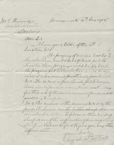
Letter, Augustus Bostock to E Plumridge, 1905
... leased others. He sat on the court of Warrnambool, Mortlake or Hexham as required. He resided at Marramook in Hawkesdale and later moved to Vaucluse in Hopetoun Road Warrnambool, where he died in 1920 at the age of 87. This letter relates to crossing sheep and answers three questions posed by Mr. E Plumridge in relation to the breeding of comeback sheep. E Plumridge is mentioned on Trove as holding...leased others. He sat on the court of Warrnambool, Mortlake or Hexham as required. He resided at Marramook in Hawkesdale and later moved to Vaucluse in Hopetoun Road Warrnambool, where he died in 1920 at the age of 87. This letter relates to crossing sheep and answers three questions posed by Mr. E Plumridge in relation to the breeding of comeback sheep. E Plumridge is mentioned on Trove as holding ...Augustus Bostock was the 9th child of Robert & Rachael Bostock of Vaucluse Epping Forest, Van Diemen’s Land. He was only 4 years old when his mother died. He was inspired by his father to seek his fortune in the Western District of Victoria. He arrived around 1850. He married Margaret Aitkin in July 1865. Augustus owned several properties in the district and leased others. He sat on the court of Warrnambool, Mortlake or Hexham as required. He resided at Marramook in Hawkesdale and later moved to Vaucluse in Hopetoun Road Warrnambool, where he died in 1920 at the age of 87. This letter relates to crossing sheep and answers three questions posed by Mr. E Plumridge in relation to the breeding of comeback sheep. E Plumridge is mentioned on Trove as holding classes in wool classing at Gordon technical College at Geelong. This is one of a number of documents which relate to the Bostock family who were one of the most important pioneering families of the Western District. They owned and leased various properties around Warrnambool and were involved in many aspects of social and business life. This letter reflects the knowledge and experience of Augustus Bostock in the breeding of sheep and also his willingness to share this knowledge. It therefore has social and historical significance.Cream lined paper with wide margin on left hand side. One page written in black ink.Addressed from Marramook 16th Jan 1905 to Mr. E Plumridge of Marshalltown. Signed Augustus Bostock.augustus bostock, plumridge geelong, marramook, warrnambool -
 Kiewa Valley Historical Society
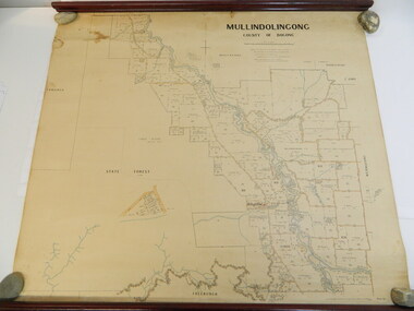
Map - Kiewa Valley, Parish Map of Mullindolingong, 12/10/1906
... These people had leases or licences giving the reader an insight into the number of people in the area and an understanding of the size of their holdings. ...These people had leases or licences giving the reader an insight into the number of people in the area and an understanding of the size of their holdings. ...The map shows the names of people living in the parish of Mullindolingong in 1906. These people had leases or licences giving the reader an insight into the number of people in the area and an understanding of the size of their holdings. Infrastructure is also given including shops, schools, churches etc. Presumably it was used by the Ryder family.This map gives an historical insight into the parish of Mullindolingong as it names people and the infrastructure - roads, buildings etc. as it was in 1906. This enables the reader to compare the area at the time with other times and other places and to have an understanding of the early settlers in the area.This is a very old paper or parchment map with wooden rods top and bottom. The top rod has ribbons attached to enable hanging. The map shows the current leases and licences and when they were held by during this period, circa 1906.Mullindolingong County of Bogong. This plan has been prepared by The Most Reliable Data in the Possession of the Department up to the date of its Compilation. Information respecting Leases or Licences which await Final Completion is not recorded.parish of mullindolingong map; ryder family; early settlers; -
 The Beechworth Burke Museum
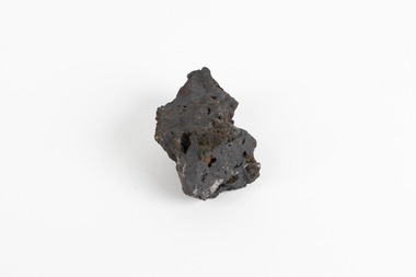
Geological specimen - Hematite (iron oxide)
... leases). This mineral specimen was collected from the Middleback Ranges before the area was identified as holding large reserves of iron ore and being commercially mined and is representative of South Australia's significant and ongoing history of iron ore mining, and its contribution to Australia's steel manufacturing industry of the early 20th century (this specimen being collected in the prelude to these events). ...Hematite is an iron ore significant for its high iron content (70%) and as being one of the two main iron oxide minerals, the other being magnetite. Hematite has a rating of 5-6 on the Moh's hardness scale and is often found as an accessory mineral in many igneous rocks. (an accessory mineral being "any mineral in an igneous rock not essential to the naming of the rock" - Britannica) Hematite has historically been the mainstay of South Australia’s iron ore production. (Magnetite: South Australia’s potential) Making up the eastern section of the Gawler Rangers, the Middleback Range is a mountain range on the eastern side of Eyre Peninsula in South Australia that has been a source of iron ore (its main commodity in minerals) for over a century. (see https://www.mindat.org/loc-22576.html). "Large reserves of high-grade iron ore were identified in 1890 in the Middleback Range, west of Whyalla. From 1915 these ores were shipped to Newcastle and later to Port Kembla, both in New South Wales. Local production of pig iron began when the first blast furnace was opened at Whyalla in 1941, and construction of an integrated iron and steel plant began there in 1958." (Britannica, South Australia: Resources and power). This area is home to 24 mines/mineral deposits (according to mindat.org, thought the Sarig Map provided by SA gov on their Energy and Mining website indicates significantly more mining leases).This mineral specimen was collected from the Middleback Ranges before the area was identified as holding large reserves of iron ore and being commercially mined and is representative of South Australia's significant and ongoing history of iron ore mining, and its contribution to Australia's steel manufacturing industry of the early 20th century (this specimen being collected in the prelude to these events).A small ferric oxide mineral composition a mid-blue-grey in colour with specks of rust-brown throughout.HEMATITE / (iron oxide) / Locality: Middleback Ranges, S. Aust.middleback ranges, iron ore mining, mining, south australia -
 Mission to Seafarers Victoria
Furniture - Desk Lectern, Mid 20th Century
... The Port of Melbourne was leased to private operators post 2015, State Govt remains landowner and regulatory authority. The Company of Master Mariners continues a regular association with the Mission to Seafarers regularly holding events and meetings on the premises....Mission to Seafarers Victoria 717 Flinders Street Docklands melbourne The Port of Melbourne was leased to private operators post 2015, State Govt remains landowner and regulatory authority. The Company of Master Mariners continues a regular association with the Mission to Seafarers regularly holding events and meetings on the premises. ...The Port of Melbourne was leased to private operators post 2015, State Govt remains landowner and regulatory authority. The Company of Master Mariners continues a regular association with the Mission to Seafarers regularly holding events and meetings on the premises.The Port of Melbourne insignia on this desk lectern may well be replaced in subsequent decades. The desk is used for presentations at many events.Wood cabinetry desk lectern with sloped reading surface and bearing two wooden shield mounted insignia, one above the other. Uppermost Insignia a) features a crest supported by 2 flanking seahorses and shield with victorian flag and 2 enamelled ribbons with inscription. Insignia B features circular crest with a 'coronet' of sail and galleon surmounting a ropework crest with an Anchor and chain at the centre.Insignia a) "PROSPERITY THROUGH SERVICE" / PORT OF MELBOURNE Insignia b) COMPANY OF MASTER MARINERS On inner panel of lectern in gilt lettering "Company of / Master Mariners "master mariners, the port of melbourne, mission to seafarers -
 Phillip Island and District Historical Society Inc.
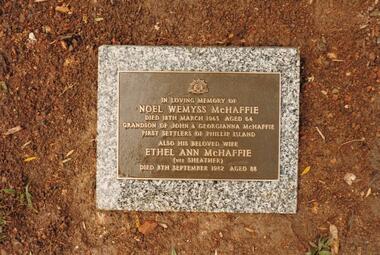
Photograph Album, Kodak, Phillip Island Cemetery, c 1990
... 4 photographs relating to the McHaffie family. 466-15 & 466-16: Noel Wemyss & Vernon Suter Wemyss McHaffie were grandchildren of the first permanent European Settlers of Phillip Island (John David & Georgianna McHarrie who leased the whole Island as a sheep and cattle run for 45 years until Closer Settlement in 1868 reduced their holding to 640 acres and who are buried at the St. ...There are 6.2 acres of wetlands near the cemetery entrance. phillip island cemetery nancy mchaffie edith jeffrey 4 photographs relating to the McHaffie family. 466-15 & 466-16: Noel Wemyss & Vernon Suter Wemyss McHaffie were grandchildren of the first permanent European Settlers of Phillip Island (John David & Georgianna McHarrie who leased the whole Island as a sheep and cattle run for 45 years until Closer Settlement in 1868 reduced their holding to 640 acres and who are buried at the St. ...The Album was compiled by Nancy McHaffie late 1990's, with the assistance of Edith Jeffery's, with her book "Garden of Memories" and extensive knowledge of Phillip Island. The Cemetery lies back from the road and is surrounded by Manna Gums, rare Peppermint Gums, Blackwoods and other native trees. In all 25 acres of land were set aside as Crown Land in the land settlement of 1868. There are 6.2 acres of wetlands near the cemetery entrance.4 photographs relating to the McHaffie family. 466-15 & 466-16: Noel Wemyss & Vernon Suter Wemyss McHaffie were grandchildren of the first permanent European Settlers of Phillip Island (John David & Georgianna McHarrie who leased the whole Island as a sheep and cattle run for 45 years until Closer Settlement in 1868 reduced their holding to 640 acres and who are buried at the St. Kilda Cemetery, Melbourne). Noel's ashes are interred at the Phillip Island Cemetery and Vernon's were scattered at Ventnor Philip Island at the site of the original homestead. 466-17 & 466-18: As per the Plaque: "Mulberry Tree: Muberry cutting from original tree planted by John D McHaffie First Settlers Phillip Island 1842. Plaque by courtesy Cherry McFee 1987.phillip island cemetery, nancy mchaffie, edith jeffrey -
 Eltham District Historical Society Inc
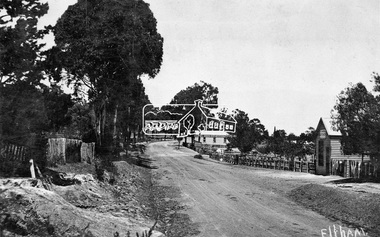
Negative - Photograph, Tom Prior, Main Road near Eltham Railway Station, c.1910
... lease expired and the premises were bought by Mrs Sarah Burgoyne in 1902. The store later was known as Staff's Store. In the distance approximately mid-way between the Butcher shop and the Bakery are the tops of what appears to be two cypress trees, which could well be the trees in front of the Shillinglaw Cottage facing Main Road. On the eastern (left) side of Main Street is Haley’s Paddock, which was used on occasions for community picnics. Capable of holding...lease expired and the premises were bought by Mrs Sarah Burgoyne in 1902. The store later was known as Staff's Store. In the distance approximately mid-way between the Butcher shop and the Bakery are the tops of what appears to be two cypress trees, which could well be the trees in front of the Shillinglaw Cottage facing Main Road. On the eastern (left) side of Main Street is Haley’s Paddock, which was used on occasions for community picnics. Capable of holding ...View looking south along Main Road, Eltham from near present day Luck Street. On the immediate right is a fence with the words “Hot Water” painted on it followed by William J Capewell’s butcher shop, then the slaughter yard and saleyards with the entrance access to the railway station. Contained within the saleyards facing the street, a small shelter with the name H.H. Clark upon it. Horace Harold Clark was the son of Eltham State School’s first Head Teacher, David George Clark. As well as being a farmer, he was an Estate Agent and conducted auction sales, presumably from this shelter. The large weatherboard building on the corner (opposite present-day Arthur Street) with signs for Summer Drinks and Hot Water painted on the side is Luther and Ada Haley’s General Store and Bakery, built 1902. This was the first building in what is now Eltham’s present shopping town centre. Haley previously ran the General Store and Bakery on the corner of Main Road and York Street until his lease expired and the premises were bought by Mrs Sarah Burgoyne in 1902. The store later was known as Staff's Store. In the distance approximately mid-way between the Butcher shop and the Bakery are the tops of what appears to be two cypress trees, which could well be the trees in front of the Shillinglaw Cottage facing Main Road. On the eastern (left) side of Main Street is Haley’s Paddock, which was used on occasions for community picnics. Capable of holding 10,000 people, with ample shade and hilly surroundings it was an ideal place for any community gathering such as the State Schools’ Picnic in 1904. Picture dated as c.1910 based on similar picture published in the Weekly Times, Feb. 1912. Kerb and channelling added 1923. Cross Ref: 610 (looking north), 611 (later stage), 613. Same as 705 (though in better condition)This photo forms part of a collection of photographs gathered by the Shire of Eltham for their centenary project book,"Pioneers and Painters: 100 years of the Shire of Eltham" by Alan Marshall (1971). The collection of over 500 images is held in partnership between Eltham District Historical Society and Yarra Plenty Regional Library (Eltham Library) and is now formally known as the 'The Shire of Eltham Pioneers Photograph Collection.' It is significant in being the first community sourced collection representing the places and people of the Shire's first one hundred years.Digital image 4 x 5 inch B&W Neg 120 format B&W negative (spare)shire of eltham pioneers photograph collection, eltham, main road, butcher, eltham railway station, railway station, w.j. capewell, baker, eltham town centre, general store, luther haley, reynolds prior collection, shops, haley's paddock, hot water, m.m. clark, sign, summer drinks, eltham sale yards, eltham slaughter yard, staffs general store -
 Charlton Golden Grains Museum Inc
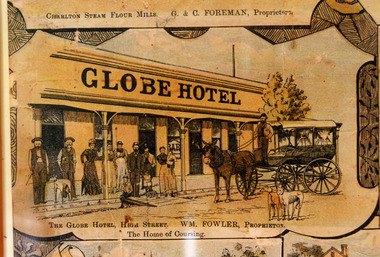
Photograph - Lithograph, Rider & Mercer, Views of Charlton, c.1988
... Leased by William Fowler in 1891 who had been in Charlton since 1877. Lithograph Globe Hotel Fowler William Walsh John The Globe Hotel, High Street. WM. Fowler, Proprietor. The Home of Coursing. Copy of Lithograph of Charlton buildings. Large sign on building 'GLOBE HOTEL'. Eight men and women and three children standing in front of building, a horse and wagon also in front of the building with a man standing in the wagon holding ...The Globe Hotel built 1874-75 for John Walsh was destroyed by fire and rebuilt in ?. Leased by William Fowler in 1891 who had been in Charlton since 1877. Copy of Lithograph of Charlton buildings. Large sign on building 'GLOBE HOTEL'. Eight men and women and three children standing in front of building, a horse and wagon also in front of the building with a man standing in the wagon holding the reins. Two greyhounds on the road.The Globe Hotel, High Street. WM. Fowler, Proprietor. The Home of Coursing.lithograph, globe hotel, fowler william, walsh john -
 Bendigo Historical Society Inc.
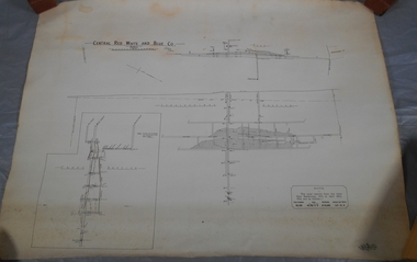
Plan - Central Red, White and Blue Mine
... Author: H E Whitelaw Share Abstract Early in 1910, some considerable time after it had become generally known that a rich reef at a depth of 405 ft was being worked southward from the privately owned Lansell's Little 180 shaft and immediately following the plotting of the Geological Survey pitch diagram of the Sheepshead line of reefs, some wide awake local mining men seized the opportunity to secure the holding known as Eadie's which, overlapping Lansell's lease and containing a stretch of the Sheepshead reef channel between the Little 180 north and south shafts, had been declared void some five years previously. ...Author: H E Whitelaw Share Abstract Early in 1910, some considerable time after it had become generally known that a rich reef at a depth of 405 ft was being worked southward from the privately owned Lansell's Little 180 shaft and immediately following the plotting of the Geological Survey pitch diagram of the Sheepshead line of reefs, some wide awake local mining men seized the opportunity to secure the holding known as Eadie's which, overlapping Lansell's lease and containing a stretch of the Sheepshead reef channel between the Little 180 north and south shafts, had been declared void some five years previously. ...The Central Red White and Blue Gold Mine was Bendigo's leading gold mine from 1910 - 1913. During the mine's operation, the main shaft was sunk 670 metres, and retrieved over 2500KG of gold. The Central Red White and Blue Gold Mine was located on the corner of Chum St and Honeysuckle St in Golden Square. Extract from Whitelaw Report: Central Red White and Blue Mine, Bendigo. Author: H E Whitelaw Share Abstract Early in 1910, some considerable time after it had become generally known that a rich reef at a depth of 405 ft was being worked southward from the privately owned Lansell's Little 180 shaft and immediately following the plotting of the Geological Survey pitch diagram of the Sheepshead line of reefs, some wide awake local mining men seized the opportunity to secure the holding known as Eadie's which, overlapping Lansell's lease and containing a stretch of the Sheepshead reef channel between the Little 180 north and south shafts, had been declared void some five years previously. That the Lansell Estate did not acquire this property on its becoming available is puzzling in the light of the fact that in Eadie's day the late Mr G W Lansell, on discovering auriferous spurs in the south shaft (now the Central Blue) had offered 2,000 pounds for, and a percentage of gold won from the lease. https://search.informit.org/doi/10.3316/aesis.200105326 Draftsman's drawing of Central Red, White and Blue Mine Map. Printed by Troedel & Cooper Pty Ltd. Mr. H. Cundy, Surveyor Forms part of the Margaret Roberts Collection of mining records.bendigo, gold, map, mine, central red white & blue, margaret roberts collection, sheepshead reef -
 Bendigo Historical Society Inc.
Document - 'OLD TOM' MINE
... lease for 35 years and worked for 8 years while Nicholas Bolle was owner. Mr F Harritable of Sebastian worked both North and South of the 'Old Tom' claim 43 years ago, when it was a miner's right holding. ...lease for 35 years and worked for 8 years while Nicholas Bolle was owner. Mr F Harritable of Sebastian worked both North and South of the 'Old Tom' claim 43 years ago, when it was a miner's right holding. ...Old Tom Mine, Whipstick. 2 pages of handwritten information, unsigned, describing the potential of the 'Old Tom' Reef.. Mr Charles Darr resided on the lease for 35 years and worked for 8 years while Nicholas Bolle was owner. Mr F Harritable of Sebastian worked both North and South of the 'Old Tom' claim 43 years ago, when it was a miner's right holding. He states it is one of the best investments in this district.cottage, miners, old tom mine, mr charles darr, mr f harritable -
 Flagstaff Hill Maritime Museum and Village
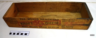
Box, 1926 - 1950
... holding 1 Dozen (12) 8 ounce (250g) cartons of cheese. It appears, by the hand written label “POISONS FOR PESTS” that it was later used for storage of pesticides. Kraft Walker Cheese Company Pty. Ltd, was established in Melbourne in 1926 by Fred Walker (creator of Vegemite). In 1934 the company leased...holding 1 Dozen (12) 8 ounce (250g) cartons of cheese. It appears, by the hand written label “POISONS FOR PESTS” that it was later used for storage of pesticides. Kraft Walker Cheese Company Pty. Ltd, was established in Melbourne in 1926 by Fred Walker (creator of Vegemite). In 1934 the company leased ...The box is made from light weight timber and only joined by nails at the sides and base. It was made for holding 1 Dozen (12) 8 ounce (250g) cartons of cheese. It appears, by the hand written label “POISONS FOR PESTS” that it was later used for storage of pesticides. Kraft Walker Cheese Company Pty. Ltd, was established in Melbourne in 1926 by Fred Walker (creator of Vegemite). In 1934 the company leased the cheese plant of the Warrnambool Cheese Factory at Warrnambool. Fred Walker died in 1935. In 1950 the company changed its name to Kraft Foods Limited. It is likely that this box was locally purchased in Warrnambool by the household of Dr Angus and the cheese used for their personal consumption. This box was donated to Flagstaff Hill Maritime Village by the family of Doctor William Roy Angus, Surgeon and Oculist. It is part of the “W.R. Angus Collection” includes historical medical equipment, surgical instruments and material once belonging to Dr Edward Ryan and Dr Thomas Francis Ryan, (both of Nhill, Victoria) as well as Dr Angus’ own belongings. The Collection’s history spans the medical practices of the two Doctors Ryan, from 1885-1926 plus that of Dr Angus, up until 1969. ABOUT THE “W.R.ANGUS COLLECTION” Doctor William Roy Angus M.B., B.S., Adel., 1923, F.R.C.S. Edin.,1928 (also known as Dr Roy Angus) was born in Murrumbeena, Victoria in 1901 and lived until 1970. He qualified as a doctor in 1923 at University of Adelaide, was Resident Medical Officer at the Royal Adelaide Hospital in 1924 and for a period was house surgeon to Sir (then Mr.) Henry Simpson Newland. Dr Angus was briefly an Assistant to Dr Riddell of Kapunda, then commenced private practice at Curramulka, Yorke Peninsula, SA, where he was physician, surgeon and chemist. In 1926, he was appointed as new Medical Assistant to Dr Thomas Francis Ryan (T.F. Ryan, or Tom), in Nhill, Victoria, where his experiences included radiology and pharmacy. In 1927 he was Acting House Surgeon in Dr Tom Ryan’s absence. Dr Angus had become engaged to Gladys Forsyth and they decided he further his studies overseas in the UK in 1927. He studied at London University College Hospital and at Edinburgh Royal Infirmary and in 1928, was awarded FRCS (Fellow from the Royal College of Surgeons), Edinburgh. He worked his passage back to Australia as a Ship’s Surgeon on the on the Australian Commonwealth Line’s T.S.S. Largs Bay. Dr Angus married Gladys in 1929, in Ballarat. (They went on to have one son (Graham 1932, born in SA) and two daughters (Helen (died 12/07/1996) and Berenice (Berry), both born at Mira, Nhill ) According to Berry, her mother Gladys made a lot of their clothes. She was very talented and did some lovely embroidery including lingerie for her trousseau and beautifully handmade baby clothes. Dr Angus was a ‘flying doctor’ for the A.I.M. (Australian Inland Ministry) Aerial Medical Service in 1928 . Its first station was in the remote town of Oodnadatta, where Dr Angus was stationed. He was locum tenens there on North-South Railway at 21 Mile Camp. He took up this ‘flying doctor’ position in response to a call from Dr John Flynn; the organisation was later known as the Flying Doctor Service, then the Royal Flying Doctor Service. A lot of his work during this time involved dental surgery also. Between 1928-1932 he was surgeon at the Curramulka Hospital, Yorke Peninsula, South Australia. In 1933 Dr Angus returned to Nhill and purchased a share of the Nelson Street practice and Mira hospital (a 2 bed ward at the Nelson Street Practice) from Dr Les Middleton one of the Middleton Brothers, the current owners of what previously once Dr Tom Ryan’s practice. Dr Tom and his brother had worked as surgeons included eye surgery. Dr Tom Ryan performed many of his operations in the Mira private hospital on his premises. He had been House Surgeon at the Nhill Hospital 1902-1926. Dr Tom Ryan had one of the only two pieces of radiology equipment in Victoria during his practicing years – The Royal Melbourne Hospital had the other one. Over the years Dr Tom Ryan had gradually set up what was effectively a training school for country general-practitioner-surgeons. Each patient was carefully examined, including using the X-ray machine, and any surgery was discussed and planned with Dr Ryan’s assistants several days in advance. Dr Angus gained experience in using the X-ray machine there during his time as assistant to Dr Ryan. When Dr Angus bought into the Nelson Street premises in Nhill he was also appointed as the Nhill Hospital’s Honorary House Surgeon 1933-1938. His practitioner’s plate from his Nhill surgery is now mounted on the doorway to the Port Medical Office at Flagstaff Hill Maritime Village, Warrnambool. When Dr Angus took up practice in the Dr Edward and Dr Tom Ryan’s old premises he obtained their extensive collection of historical medical equipment and materials spanning 1884-1926. A large part of this collection is now on display at the Port Medical Office at Flagstaff Hill Maritime Village in Warrnambool. In 1939 Dr Angus and his family moved to Warrnambool where he purchased “Birchwood,” the 1852 home and medical practice of Dr John Hunter Henderson, at 214 Koroit Street. (This property was sold in1965 to the State Government and is now the site of the Warrnambool Police Station. and an ALDI sore is on the land that was once their tennis court). The Angus family was able to afford gardeners, cooks and maids; their home was a popular place for visiting dignitaries to stay whilst visiting Warrnambool. Dr Angus had his own silk worm farm at home in a Mulberry tree. His young daughter used his centrifuge for spinning the silk. Dr Angus was appointed on a part-time basis as Port Medical Officer (Health Officer) in Warrnambool and held this position until the 1940’s when the government no longer required the service of a Port Medical Officer in Warrnambool; he was thus Warrnambool’s last serving Port Medical Officer. (Masters of immigrant ships arriving in port reported incidents of diseases, illness and death and the Port Medical Officer made a decision on whether the ship required Quarantine and for how long, in this way preventing contagious illness from spreading from new immigrants to the residents already in the colony.) Dr Angus was a member of the Australian Medical Association, for 35 years and surgeon at the Warrnambool Base Hospital 1939-1942, He served as a Surgeon Captain during WWII1942-45, in Ballarat, Victoria, and in Bonegilla, N.S.W., completing his service just before the end of the war due to suffering from a heart attack. During his convalescence he carved an intricate and ‘most artistic’ chess set from the material that dentures were made from. He then studied ophthalmology at the Royal Melbourne Eye and Ear Hospital and created cosmetically superior artificial eyes by pioneering using the intrascleral cartilage. Angus received accolades from the Ophthalmological Society of Australasia for this work. He returned to Warrnambool to commence practice as an ophthalmologist, pioneering in artificial eye improvements. He was Honorary Consultant Ophthalmologist to Warrnambool Base Hospital for 31 years. He made monthly visits to Portland as a visiting surgeon, to perform eye surgery. He represented the Victorian South-West subdivision of the Australian Medical Association as its secretary between 1949 and 1956 and as chairman from 1956 to 1958. In 1968 Dr Angus was elected member of Spain’s Barraquer Institute of Barcelona after his research work in Intrasclearal cartilage grafting, becoming one of the few Australian ophthalmologists to receive this honour, and in the following year presented his final paper on Living Intrasclearal Cartilage Implants at the Inaugural Meeting of the Australian College of Ophthalmologists in Melbourne In his personal life Dr Angus was a Presbyterian and treated Sunday as a Sabbath, a day of rest. He would visit 3 or 4 country patients on a Sunday, taking his children along ‘for the ride’ and to visit with him. Sunday evenings he would play the pianola and sing Scottish songs to his family. One of Dr Angus’ patients was Margaret MacKenzie, author of a book on local shipwrecks that she’d seen as an eye witness from the late 1880’s in Peterborough, Victoria. In the early 1950’s Dr Angus, painted a picture of a shipwreck for the cover jacket of Margaret’s book, Shipwrecks and More Shipwrecks. She was blind in later life and her daughter wrote the actual book for her. Dr Angus and his wife Gladys were very involved in Warrnambool’s society with a strong interest in civic affairs. He had an interest in people and the community They were both involved in the creation of Flagstaff Hill, including the layout of the gardens. After his death (28th March 1970) his family requested his practitioner’s plate, medical instruments and some personal belongings be displayed in the Port Medical Office surgery at Flagstaff Hill Maritime Village, and be called the “W. R. Angus Collection”. This box is of local and state significant for its association with the W.R. Angus Collection and with the local Kraft Walker Cheese Company in Allansford, and for being a company that began in Melbourne. The W.R. Angus Collection is significant for still being located at the site it is connected with, Doctor Angus being the last Port Medical Officer in Warrnambool. The collection of medical instruments and other equipment is culturally significant, being an historical example of medicine from late 19th to mid-20th century. Dr Angus assisted Dr Tom Ryan, a pioneer in the use of X-rays and in ocular surgery. Box, wooden, part of the W.R. Angus Colleciton. Small wooden rectangular box without a lid, sides and base joined by nails. It once contained Kraft Cheese, as per the stenciled printing on the sides of the box in red and black. Later a hand written label has been attached to one end indicating that it was used for storing poisons. C. 1926 - 1950Label, hand written, attached to end; "POISONS FOR PESTS". Stencils printed in red and black "THE WORLD RENOWNED / KRAFT WALKER CHEESE COY PTY LTD" "PATENTED JULY 26 1916", "GUARANTEED TO COMPLY WITH ALL THE FOOD LAWS", "1Doz 8oz CARTONS", "BLENDED / PASTURISED / PACKED"flagstaff hill, warrnambool, shipwrecked coast, flagstaff hill maritime museum, maritime museum, shipwreck coast, flagstaff hill maritime village, great ocean road, dr w r angus, kraft walker cheese company pty ltd, cheese box, cheese crate, kraft cheese crate, cheese box 1926 - 1950, kraft cheese, kraft walker cheese co allansford, kraft walker cheese co warrnambool, fred walker, label poisons for pests, poison storage -
 Orbost & District Historical Society
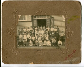
black and white photograph, Vogt, Stanley, C 1915-1920
... holding the sign as Pen Gilbert. The 19th of March 1886 proved an important day in the lives of many early settlers in the Orbost area, because on this day the Orbost State School opened. The fact that the school had first operated temporarily in a leased...holding the sign as Pen Gilbert. The 19th of March 1886 proved an important day in the lives of many early settlers in the Orbost area, because on this day the Orbost State School opened. The fact that the school had first operated temporarily in a leased ...This is a photograph of students of Orbost State School. Mary Gilbert has identified the girl holding the sign as Pen Gilbert. The 19th of March 1886 proved an important day in the lives of many early settlers in the Orbost area, because on this day the Orbost State School opened. The fact that the school had first operated temporarily in a leased building, and on a half-time basis with SS2745 Jarrahmond, did not dampen the enthusiasm of the local inhabitants as they saw their offspring commence their education under the guidance of HT Campbell Mackay. However he remained in charge only until 12th of May 1886. The second HT, John Rowe, served until 1908. On 30th of June 1887, a portable room was provided; it being brought to the area by schooner. The school now had accommodation for 30 pupils; the teacher's welfare was considered because quarters of two rooms were attached. As the population increased so did the needs of the school. This was reflected in the provision of a larger classroom in 1898. During 1910-11 the first approaches were made to the Department for the establishment of a HES in Orbost and this became a reality in 1912. Orbost HES supplied post-primary education in the district until a high school was built in 1948.This photograph is associate with the history of education i n Orbost.a black / white photograph mounted on brown card. It is of a group of school children in front of an open doorwaay of a timber building. A female teacher is seated on a chair among them. A girl in the front is holding a board with what appears to be handwritten in white chalk on a blackboard -"Grades 111 & 1V Orbost".at bottom - "X PEN GILBERT"education-orbost-state-school -
 Bacchus Marsh & District Historical Society
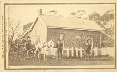
Photograph, Thomas Mason House and Family Bacchus Marsh 1883
... holding the reins of the horse is possibly Thomas Mason. One of the two women seated in the buggy is possibly his wife Catherine Mason (nee Whelan). This house was built by grazier George Palmer Hall around 1846-1848 north of what is now Lerderderg Street, Bacchus Marsh, at a point close to the Lerderderg River. The house and the accompanying farm of over 5,000 hectares was leased...holding the reins of the horse is possibly Thomas Mason. One of the two women seated in the buggy is possibly his wife Catherine Mason (nee Whelan). This house was built by grazier George Palmer Hall around 1846-1848 north of what is now Lerderderg Street, Bacchus Marsh, at a point close to the Lerderderg River. The house and the accompanying farm of over 5,000 hectares was leased ...This image shows the house occupied by Thomas Mason and his family in 1883. The man in the centre of the image holding the reins of the horse is possibly Thomas Mason. One of the two women seated in the buggy is possibly his wife Catherine Mason (nee Whelan). This house was built by grazier George Palmer Hall around 1846-1848 north of what is now Lerderderg Street, Bacchus Marsh, at a point close to the Lerderderg River. The house and the accompanying farm of over 5,000 hectares was leased by George Ball to George Hobler in the late 1840s and early 1850s. During this time George Hobler's daughter Emily married Henry Bacchus the son of Captain William Bacchus. By 1865 Thomas Mason had purchased the property. Mason named the property Riverton. After his death in the 1890s the property was owned by a number of different people. The house was still in use until 1999 but since this time has been unoccupied and its condition has significantly deteriorated.This image is significant because it depicts one of the earliest houses built in the town of Bacchus Marsh. It is probably the earliest surviving image of this Bacchus Marsh pre-gold rush structure.Small sepia unframed photograph on card with gold border framing photograph. Housed in the album, 'Photographs of Bacchus Marsh and District in 1883 by Stevenson and McNicoll'. The image shows a brick house, with an iron roof and with a white picket fence around the front garden. There is a buggy to the left of the image with two women seated in it. A man stands in front of the buggy holding the reins of a white horse which is harnessed to the buggy. Further to the right of the image is an older man with his hands in his pockets. On the front: Stevenson & McNicoll. Photo. 108 Elizabeth St. Melbourne. COPIES CAN BE OBTAINED AT ANY TIME. On the back: LIGHT & TRUTH inscribed on a banner surmounted by a representation of the rising sun. Copies of this Portrait can be had at any time by sending the Name and Post Office Money Order or Stamps for the amount of order to STEVENSON & McNICOLL LATE BENSON & STEVENSON, Photographers. 108 Elizabeth Street, MELBOURNE stevenson and mcnicoll 1883 photographs of bacchus marsh and district, houses bacchus marsh, george hobler 1800-1882, henry bacchus 1820-1887, emily bacchus, mason family bacchus marsh -
 Falls Creek Historical Society
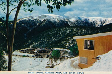
Booklet - Diana Lodge
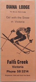
... leased Diana Lodge to Bob Scott and it also became the Post Office and Telephone Exchange. From early early 1967 until about 1975, Diana Lodge was owned and operated by John and Gwyn van Burck. It was then purchased by a group of 12 families operating as Swan Hill Alpine Holdings...leased Diana Lodge to Bob Scott and it also became the Post Office and Telephone Exchange. From early early 1967 until about 1975, Diana Lodge was owned and operated by John and Gwyn van Burck. It was then purchased by a group of 12 families operating as Swan Hill Alpine Holdings ...Diana Lodge was built and operated by Kevin Shoebridge as a family lodge in the 1950s and it has grown and evolved over 60 years to become Diana Alpine Lodge. After Mr. Shoebridge moved to Wodonga he leased Diana Lodge to Bob Scott and it also became the Post Office and Telephone Exchange. From early early 1967 until about 1975, Diana Lodge was owned and operated by John and Gwyn van Burck. It was then purchased by a group of 12 families operating as Swan Hill Alpine Holdings. Diana Alpine Lodge has operated under several owners and was sold again as recently as 2023.This brochure is significant because it is linked to one of the early lodges established in Falls Creek.A small tan coloured brochure with black text, The cover features an image of a skier.Above image: DIANA LODGE The Ski-out, Ski-in Lodge Go! with the Snow in Victoria Below the image: Fall's Creek Victoria Phone 58 3214 Proprietors: John and Gwyn van Burckdiana alpine lodge, falls creek accommodation -
 Kew Historical Society Inc
Textile, Damask Tablecloth embroidered with the Greenlaw Crest, 1882-1890
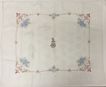
... lease then passed to Samuel and Esther Fripp, who went on to purchase the property in 1918 after Anna Maria Greenlaw’s death in 1918. This rare textile is associated with the most significant period of Villa Alba's history and is an example of the colonial aspirations of its citizens in the boom years of the 1880s before the crash that engulfed the owner. villa alba william greenlaw tablecloths Greenlaw crest - griffin holding thistle in beak over initials WG Small white damask tablecloth or napkin embroidered with the crest of William Greenlaw, the owner of Villa Alba in Walmer Street, Kew. ...When the newly married William and Anna Maria Greenlaw acquired the property in 1862, an existing house known as Studley Villa stood on the land. John Hodgson probably built the latter soon after he bought three portions of land here in 1853. The Greenlaws changed the name of the residence to Villa Alba in about 1870 and in 1882-84 rebuilt the house to create the present mansion. After William Greenlaw’s death in 1895, John Ballinger rented the house until 1914. The lease then passed to Samuel and Esther Fripp, who went on to purchase the property in 1918 after Anna Maria Greenlaw’s death in 1918.This rare textile is associated with the most significant period of Villa Alba's history and is an example of the colonial aspirations of its citizens in the boom years of the 1880s before the crash that engulfed the owner.Small white damask tablecloth or napkin embroidered with the crest of William Greenlaw, the owner of Villa Alba in Walmer Street, Kew. The embroidery of the crest and borders of garlands are completed in multicoloured silk thread.Greenlaw crest - griffin holding thistle in beak over initials WGvilla alba, william greenlaw, tablecloths -
 Falls Creek Historical Society
Memorabilia - Diana Ski Lodge Banner
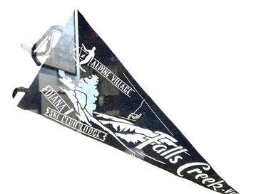
... leased Diana Lodge to Bob Scott and it also became the Post Office and Telephone Exchange. From early 1967 until about 1975, Diana Lodge was owned and operated by John and Gwyn van Burck. It was then purchased by a group of 12 families operating as Swan Hill Alpine Holdings...leased Diana Lodge to Bob Scott and it also became the Post Office and Telephone Exchange. From early 1967 until about 1975, Diana Lodge was owned and operated by John and Gwyn van Burck. It was then purchased by a group of 12 families operating as Swan Hill Alpine Holdings ...Diana Lodge was built and operated by Kevin Shoebridge as a family lodge in the 1950s and it has grown and evolved over 60 years to become Diana Alpine Lodge. After Mr Shoebridge moved to Wodonga he leased Diana Lodge to Bob Scott and it also became the Post Office and Telephone Exchange. From early 1967 until about 1975, Diana Lodge was owned and operated by John and Gwyn van Burck. It was then purchased by a group of 12 families operating as Swan Hill Alpine Holdings. Diana Alpine Lodge has operated under several owners and was sold again as recently as 2023. This pennant was used in the early 1960s as a souvenir to promote Diana Lodge.This item is significant because it promotes Diana Lodge, a long standing accommodation venue at Falls Creek.A black and white triangular banner including an image of a skier and a second person on a chair lift.ALPINE VILLAGE DIANA SKI CLUB LODGE FALLS CREEK, VICdiana alpine lodge, falls creek accommodation -
 Bacchus Marsh & District Historical Society
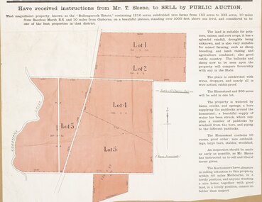
Map, Bullengarook Estate Property Sale. 1911
... Pastoral leases for European colonists were granted to people for this area from around the 1840s.The Bullengarook Estate was part of these early pastoral holdings. ...Pastoral leases for European colonists were granted to people for this area from around the 1840s.The Bullengarook Estate was part of these early pastoral holdings. ...Bullengarook is a locality located 19 kilometers north of Bacchus Marsh. Pastoral leases for European colonists were granted to people for this area from around the 1840s.The Bullengarook Estate was part of these early pastoral holdings. By the 1900s the property had been owned by the Skene family for a number of years. In early 1911 the property then consisting of 300 acres and the homestead upon it was offered for sale in one lot. It appears however that the sale of the property did not go through in 1911. It was later leased by Thomas Skene to a Mr Coutts in 1915 and ultimately and at a later stage the property was sold by the Skene family.A single page paper map showing land allotments for sale from the Bullengarook Estate. The map is pasted into a bound volume containing 76 maps or plans in total. High resolution digital image stored on BMDHS computer network. land sales bacchus marsh, bullengarook land sales, bullengarook estate, bullengarook vic history -
 Falls Creek Historical Society
Postcard - Diana Lodge, Falls Creek
... leased Diana Lodge to Bob Scott and it also became the Post Office and Telephone Exchange. From early early 1967 until about 1975, Diana Lodge was owned and operated by John and Gwyn van Burck. It was then purchased by a group of 12 families operating as Swan Hill Alpine Holdings...leased Diana Lodge to Bob Scott and it also became the Post Office and Telephone Exchange. From early early 1967 until about 1975, Diana Lodge was owned and operated by John and Gwyn van Burck. It was then purchased by a group of 12 families operating as Swan Hill Alpine Holdings ...These photographs were taken in and around Falls Creek by Samuel Keith Pearce and printed for him as a foldout postcard by NuColor Vue. The postcards state they were printed for S. K. Pearce Pty. Ltd of Tawonga and Mount Beauty. Diana Lodge was built and operated by Kevin Shoebridge as a family lodge in the 1950s and it has grown and evolved over 60 years to become Diana Alpine Lodge. After Mr. Shoebridge moved to Wodonga he leased Diana Lodge to Bob Scott and it also became the Post Office and Telephone Exchange. From early early 1967 until about 1975, Diana Lodge was owned and operated by John and Gwyn van Burck. It was then purchased by a group of 12 families operating as Swan Hill Alpine Holdings. Diana Alpine Lodge has operated under several owners and was sold again as recently as 2023.This collection of postcards and images is significant because they were commissioned by a highly successful businessman in Falls Creek, Victoria and showcase the Falls Creek Tourist Area.The coloured postcard of Diana Lodge at Falls Creek.falls creek village, postcards falls creek, s. k. pearce -
 Bendigo Historical Society Inc.
Map - Central Red White and Blue Co, 1913
... Author: H E Whitelaw Abstract Early in 1910, some considerable time after it had become generally known that a rich reef at a depth of 405 ft was being worked southward from the privately owned Lansell's Little 180 shaft and immediately following the plotting of the Geological Survey pitch diagram of the Sheepshead line of reefs, some wide awake local mining men seized the opportunity to secure the holding known as Eadie's which, overlapping Lansell's lease and containing a stretch of the Sheepshead reef channel between the Little 180 north and south shafts, had been declared void some five years previously. ...Author: H E Whitelaw Abstract Early in 1910, some considerable time after it had become generally known that a rich reef at a depth of 405 ft was being worked southward from the privately owned Lansell's Little 180 shaft and immediately following the plotting of the Geological Survey pitch diagram of the Sheepshead line of reefs, some wide awake local mining men seized the opportunity to secure the holding known as Eadie's which, overlapping Lansell's lease and containing a stretch of the Sheepshead reef channel between the Little 180 north and south shafts, had been declared void some five years previously. ...The Central Red White and Blue Gold Mine was Bendigo's leading gold mine from 1910 - 1913. During the mine's operation, the main shaft was sunk 670 metres, and retrieved over 2500KG of gold. The Central Red White and Blue Gold Mine was located on the corner of Chum St and Honeysuckle St in Golden Square.. During the mine's operation, the main shaft was sunk 670 metres, and retrieved over 2500KG of gold. The registration of the Company in 1891 (Government Gazette 138, November 6th. 1891, page 4465) lists the value of the Company's property as three hundred and fifty pounds. The number of shares was thirty thousand at 2 shillings each. The Manager was Mr. William Weeks Barker. Ref: https://gazette.slv.vic.gov.au/view.cgi?year=1891&class=general&page_num=4465&state=v&classnum=g138&id= Extract from Whitelaw Report: Central Red White and Blue Mine, Bendigo. Author: H E Whitelaw Abstract Early in 1910, some considerable time after it had become generally known that a rich reef at a depth of 405 ft was being worked southward from the privately owned Lansell's Little 180 shaft and immediately following the plotting of the Geological Survey pitch diagram of the Sheepshead line of reefs, some wide awake local mining men seized the opportunity to secure the holding known as Eadie's which, overlapping Lansell's lease and containing a stretch of the Sheepshead reef channel between the Little 180 north and south shafts, had been declared void some five years previously. That the Lansell Estate did not acquire this property on its becoming available is puzzling in the light of the fact that in Eadie's day the late Mr G W Lansell, on discovering auriferous spurs in the south shaft (now the Central Blue) had offered 2,000 pounds for, and a percentage of gold won from the lease. https://search.informit.org/doi/10.3316/aesis.200105326 Hand drawn plan of Central Red, White and Blue Mine. Cross section and longitudinal plan drawn on plan. Printed name on top of plan: 'Central Red White and Blue Co' Plan printed by Troedel & Cooper Pty Ltd. Surveyor W. H. Cundy, Bendigo April 1913 Plan is part of the Margaret Roberts Collection of mining records.bendigo, margaret roberts, gold, central red white and blue gold mine, map, margaret roberts collection