Showing 32 items matching "location chains"
-
 Federation University Historical Collection
Instrument - Scientific Instruments, Tripod Location Chains
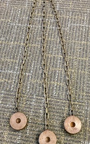
... Tripod Location Chains......location chains...Used to contain tripod ends on hard smooth surfaces. Tripod Location Chains Instrument Scientific Instruments ...Surveying instrument accessories. Two sets. Used in conjunction with item 4129 - Collapsible leg surveying instrument, tripod. Could also be used with item 4130 - Plane Table which goes with the tripod mentioned.A set of three steel discs, connected in star configuration by three brass chains of equal length. Used to contain tripod ends on hard smooth surfaces.surveying, metal, steel discs, scientific instruments, location chains, plane table -
 Federation University Historical Collection
Instrument - Scientific Instruments, W.& L.E. Gurley, Collapsible Leg Surveying Instrument: Tripod
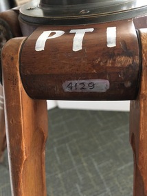
... ...location chains...Item 4127, Tripod Location Chains, may also have been used....Item 4127, Tripod Location Chains, may also have been used. tripod surveying scientific instrument ballarat school of mines plane table location chains w & l e gurley In white paint on the top "PTI" Manufacturer's stamp on each leg - circular. ...Used with the Plane Table - Item 4130, in surveying classes at Ballarat School of Mines. Item 4127, Tripod Location Chains, may also have been used.A large tripod of timber construction. Concave top mount flange to receive matching spherical spigot. Spacer block halfway up each twin-strut leg.In white paint on the top "PTI" Manufacturer's stamp on each leg - circular. "W.& L.E. GURLEYtripod, surveying, scientific instrument, ballarat school of mines, plane table, location chains, w & l e gurley -
 Federation University Historical Collection
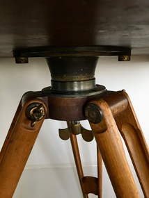
Instrument - Scientific Instrument, W.&L.E. Gurley, Plane Table
... ...location chains...It was used in conjunction with Item 04129 - Collapsible leg surveying instrument, tripod, and at times with Item 4127 - Tripod location chains....It was used in conjunction with Item 04129 - Collapsible leg surveying instrument, tripod, and at times with Item 4127 - Tripod location chains. plane table surveying w. & l.e. gurley scientific instrument ballarat school of mines tripod location chains Manufacturer's stamp underneath. ...Used at the Ballarat School of Mines in Surveying classes. It was used in conjunction with Item 04129 - Collapsible leg surveying instrument, tripod, and at times with Item 4127 - Tripod location chains.A wooden platform used in surveying equipped with a 2.7 cm diameter dowel at each end that would hold the charts/papers in position. A spherical mount on the underside, designed to match the receptacle on top of the tripod - Item 04129.Manufacturer's stamp underneath.plane table, surveying, w. & l.e. gurley, scientific instrument, ballarat school of mines, tripod, location chains -
 Warrnambool and District Historical Society Inc.
Badge, Warrnambool High School, c 1980
... locations around Warrnambool until 1961 when it moved into a purpose built building in Albert Park, Warrnambool . It merged with Warrnambool North Technical School to become Warrnambool College.in 1994..The badge is of superior quality and was probably given to visitors. This is retained as a memento of Warrnambool High School which was established over 100 years ago. Warrnambool High School Warrnambool Badge WHS Nil Sine Labore Taiwan A circular metal badge with gilt edging and the school emblem in black and gold on a green background.There is a stud clip at the back.and a a fob chain ...This is a Warrnambool High School badge . Warrnambool High School was established in 1907 and was housed in various locations around Warrnambool until 1961 when it moved into a purpose built building in Albert Park, Warrnambool . It merged with Warrnambool North Technical School to become Warrnambool College.in 1994..The badge is of superior quality and was probably given to visitors.This is retained as a memento of Warrnambool High School which was established over 100 years ago. A circular metal badge with gilt edging and the school emblem in black and gold on a green background.There is a stud clip at the back.and a a fob chain attached. WHS Nil Sine Labore Taiwan warrnambool high school, warrnambool, badge -
 Warrnambool and District Historical Society Inc.
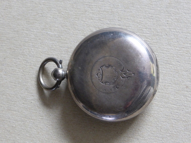
Watch, Watch Case silver, Early 20th century
... location. The case is circular in shape with two lids and an inset to hold a watch. It has a ring for the case to be attached to a chain. ...location. The case is circular in shape with two lids and an inset to hold a watch. It has a ring for the case to be attached to a chain. ...No information has been found on the original owner of the watch, A. Sartori. Pocket watches were commonly owned by men with some means and the quality of the silver in this item indicates that the watch was probably an expensive one. As no information has been found on the owner of this watch, A. Sartori, it remains of antiquarian interest only.This is a silver watch case (the watch is missing). It has three hallmarks with the number 779 in two locations and two hallmarks and the number 779 in another location. The case is circular in shape with two lids and an inset to hold a watch. It has a ring for the case to be attached to a chain. It has a shield- shaped etching on the front cover.‘A Sartori’a.sartori, watch, warrnambool -
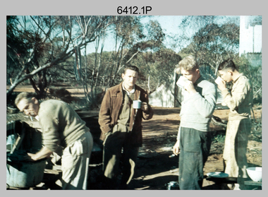
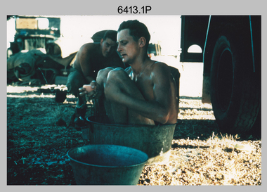
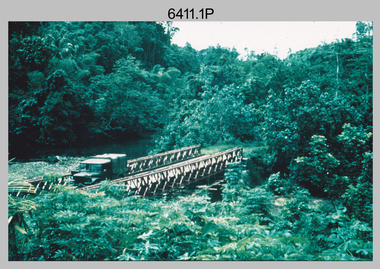 Bendigo Military Museum
Photograph - Royal Australian Survey Corps Surveyors in the Field – Project Cutlass, New Guinea, 1956 – 1957
... chains to measure base line distances between survey stations. Bob Skitch shown in photo .7P was in the 2nd year of his career in the Australian Army. He achieved the rank of Lieutenant-Colonel, and his last appointment was the CO of the Army Survey Regiment from 1976 to 1980. Royal Australian Survey Corps RASvy Army Survey Regiment Fortuna a Army Svy Regt ASR surveying .1P to .23P annotated on back – ‘Operation Cutlass’, personnel names, the year and the location ...This is a set of 23 photographs of surveyors and support staff in the field undertaking tasks in New Guinea 1956 – 1957. The surveyors were employed in the establishment of mapping and geodetic control for Project Cutlass, the “Ship-Shore” survey of the New Ireland province. In this survey operation surveyors used theodolites to observe horizontal and vertical angles and chains to measure base line distances between survey stations. Bob Skitch shown in photo .7P was in the 2nd year of his career in the Australian Army. He achieved the rank of Lieutenant-Colonel, and his last appointment was the CO of the Army Survey Regiment from 1976 to 1980.This is a set of 23 photographs of surveyors and support staff in the field undertaking duties during Project Cutlass located in New Ireland, New Guinea 1956 – 1957. The photographs were printed on photographic paper and are part of the Army Survey Regiment’s Collection. The photographs were scanned at 300 dpi. .1) - Photo, colour, 1956. Surveyors travelling main road from Kavieng to Namatanai, New Ireland. .2) - Photo, colour, 1956. Unidentified surveyors assessing recovery of their vehicle after bridge collapsed on west side of New Ireland. .3) - Photo, colour, 1956. Unidentified surveyors assessing recovery of their vehicle after bridge collapsed over flooded creek on west side of New Ireland. .4) - Photo, colour, 1956. Survey personnel L to R: Bev Uwins, John Lambie, Bob Thompson, New Ireland. .5) - Photo, colour, 1956. Survey base camp, New Ireland. .6) - Photo, black & white, 1956-1957. Geoff Helsham with possible human remains, New Ireland. .7) - Photo, black & white, 1956-1957. Bob Skitch undertaking survey observations using Wild T2 theodolite, New Ireland. .8) - Photo, black & white, 1956-1957. Chas Beach undertaking survey observations using Wild T2 theodolite, New Ireland. .9) & .10) - Photo, black & white, 1956-1957. Kev Parker (cook) New Ireland. .11) - Photo, colour, 1957. Brian Berkery taking a break, Top Manor Island, Lihir Island Group off New Ireland. Latitude -2° 46”, Longitude 152° 40”. .12) - Photo, colour, 1957. Survey base camp L to R: Chas Beach, Bev Uwins, Feni Islands, New Ireland. Latitude -4° 05”, Longitude 153° 45”. .13) - Photo, colour, 1957. A Hous Kiap. (Kiaps, known formally as district officers and patrol officers, were travelling representatives of the British and Australian governments), New Ireland. .14) & .15) - Photo, colour, 1957. L to R: Joe Farrington, Tom Royle Bob undertaking survey observations using theodolites from an improvised timber tower, New Ireland. .16) & .17) - Photo, colour, 1957. US Army ship FS216 used for ship-to-shore triangulation docked at Rabaul, New Britain. .18) - Photo, colour, 1957. US Army ship FS216 used for ship-to-shore triangulation docked at Kavieng, New Ireland. Sight target on top of mast. .19) - Photo, colour, 1957. Survey personnel onboard US Army ship FS392, L to R: Peter Frodsham, Bob Thompson, Doc Reid, John Underwood, remainder unidentified, New Ireland. .20) - Photo, colour, 1957. Survey base line party heading ashore, New Ireland. .21) - Photo, colour, 1957. Survey personnel rowing US Army assault boat L to R: Kev Parker, Chas Beach, folded up survey beacons overhanging stern, New Ireland. .22) - Photo, colour, 1957. Les Bailey onboard US Army ship departing Rabaul, New Britain for Brisbane. .23) - Photo, colour, 1957. Ron Newman onboard US Army ship departing Rabaul, New Britain for Brisbane. Active volcano in background..1P to .23P annotated on back – ‘Operation Cutlass’, personnel names, the year and the location. royal australian survey corps, rasvy, army survey regiment, fortuna, a, army svy regt, asr, surveying -
 Bendigo Military Museum
Photograph - Royal Australian Survey Corps Surveyors in the Field – Victoria, 1956 - 1958
... chains to measure base line distances between survey stations. Royal Australian Survey Corps RASvy Army Survey Regiment ASR Army Svy Regt Fortuna surveying .1P to .2P annotated on back – personnel names, the year and the location. ...This is a set of two photographs of surveyors and support staff in the field undertaking tasks in Victoria 1956 – 1958. The surveyors were employed in the establishment of mapping and geodetic control. In this era surveyors used theodolites to observe horizontal and vertical angles and chains to measure base line distances between survey stations. This is a set of 23 photographs of surveyors and support staff in the field undertaking duties in Victoria 1956 – 1958. The photographs were printed on photographic paper and are part of the Army Survey Regiment’s Collection. The photographs were scanned at 300 dpi. .1) - Photo, colour, 1956. Surveyors enjoying a tea break. L to R: Tom Gilbert (cook), Barry Broad, Tony Slattery, John Van De Graff. Taken at Boonoonar, a locality south of Mildura. .2) - Photo, colour, 1958. Surveyors taking a break from driving. L to R: Leo Bub, Bob Thompson. Taken at Puckapunyal..1P to .2P annotated on back – personnel names, the year and the location. royal australian survey corps, rasvy, army survey regiment, asr, army svy regt, fortuna, surveying -
 Bendigo Military Museum
Photograph - Royal Australian Survey Corps Surveyors in the Field – North Queensland, 1958
... chains to measure base line distances between survey stations. Bob Skitch shown in photos .4P to .6P was in the 2nd year of his career in the Australian Army. He achieved the rank of Lieutenant Colonel and his last appointment was the CO of the Army Survey Regiment from 1976 to 1980. The annotation on the back of photo .5P ‘Black foreground is where Bob Skitch boiled billy and started a grass fire’. Royal Australian Survey Corps RASvy Army Survey Regiment ASR Army Svy Regt Fortuna surveying .1P to .7P annotated on back – personnel names, the year and the location ...This is a set of seven photographs of surveyors and support staff in the field undertaking duties in North Queensland in 1958. The surveyors were employed in the establishment of mapping and geodetic control. In this era surveyors used theodolites to observe horizontal and vertical angles and chains to measure base line distances between survey stations. Bob Skitch shown in photos .4P to .6P was in the 2nd year of his career in the Australian Army. He achieved the rank of Lieutenant Colonel and his last appointment was the CO of the Army Survey Regiment from 1976 to 1980. The annotation on the back of photo .5P ‘Black foreground is where Bob Skitch boiled billy and started a grass fire’.This is a set of seven photographs of surveyors and support staff in the field undertaking duties in North Queensland in 1958. The photographs were printed on photographic paper and are part of the Army Survey Regiment’s Collection. The photographs were scanned at 300 dpi. .1) - Photo, colour, 1958. Surveyor in Nth QLD enjoying a bath. L to R: Don Cocker, Bob Thompson. .2) - Photo, colour, 1958. Don Cocker surveyor in Nth QLD, enjoying a bath. .3) - Photo, colour, 1958. Surveyors Nth QLD undertaking survey observations, using MRA1 tellurometer to measure base-line distances. L to R: Len Davies, Lou Sommer, John Van De Graff. MRA1 was covered to stop overheating. .4) - Photo, colour, 1958. Surveyors south of Richmond, QLD digging holes for the erection of a Bilby observation tower. L to R: John Van De Graff, Bob Skitch, Kev Moody, Mal Hayes, Don Gray .5) - Photo, colour, 1958. Surveyors south of Richmond, QLD erecting a Bilby observation tower. L to R: Tom Royle, Bob Skitch (on ground level), Mal Hayes. .6) - Photo, colour, 1958. Surveyors south of Richmond, QLD erecting a Bilby observation tower. L to R: Tom Royle, Bob Skitch, Mal Hayes, Jim McGill (on ground level). .7) - Photo, colour, 1958. Surveyors south of Richmond, QLD undertaking survey measurements from a Bilby observation tower..1P to .7P annotated on back – personnel names, the year and the location. Annotated on back of .5P ‘Black foreground is where Bob Skitch boiled billy and started a grass fire’.royal australian survey corps, rasvy, army survey regiment, asr, army svy regt, fortuna, surveying -
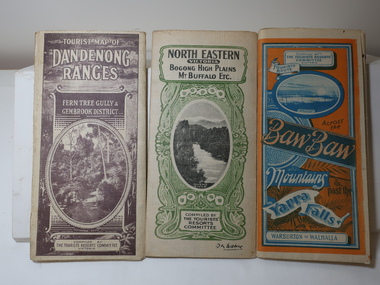 Kiewa Valley Historical Society
Maps - Tourist
... Poles about 3 chains apart 27 to the mile." 1933 Maps Tourism Maps Bogong High Plains Map 1933 snow poles By Authority of H.J. Green - 6 pence. Dept of Lands and Survey, Melbourne 3 Tourist location maps (folded) and printed on parchment. 1. ...These maps were all dated 1933 which was before the construction of the Kiewa Hydro Electric Scheme and when Tawonga was spelt Towonga. North East Victoria in 1933 was before the construction of the Kiewa Hydro Electric Scheme so the townships of Mt Beauty and Bogong are not shown. The description of the Snow Lines was important as skiers, bushwalkers and campers relied on them. The details on the map include "ADB. Numbered from A.1-377 round plates. CD Numbered from C 1-235 square plates. Poles about 3 chains apart 27 to the mile." 3 Tourist location maps (folded) and printed on parchment. 1. Tourist map of the Dandenong Ranges. Brown cover. dated 6-4-33. Govt. printer showing roads, tracks in red and heights of the land. 2. Tourist Map of Warburton, Mt Baw Baw, and Walhalla. Blue and Orange cover. dated 23-5-33 Govt. printer. 3 different maps of each area showin roads, tracks and timber tramways.Also in red and blue. 3. Tourist Map of North Eastern Victoria including Bogong High Plains Mt Buffalo Etc. Green cover. dated June 1933 Govt. printer. Main map and insert titled Bogong High Plains. Showing roads , tracks and tram ways. On insert showing snow poles. Also Red and Blue and mountains.By Authority of H.J. Green - 6 pence. Dept of Lands and Survey, Melbourne1933 maps, tourism maps, bogong high plains map 1933, snow poles -
 Wycheproof & District Historical Society Inc.
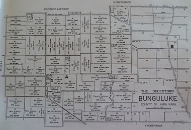
Bunguluke Map, Bunguluke District In 1923, 27.2.1923
... Wycheproof township location is shown with the Scale of Chains. Bunguluke maps for other years are also in the collection....Wycheproof township location is shown with the Scale of Chains. Bunguluke maps for other years are also in the collection. ...By 1881 Bunguluke was a small settlement as recorded, December 5, in the Charlton "Mercury". It reports that in that year Draper's Store, Hotel and Post Office and residence at Bunguluke North was totally destroyed by fire. For years now there has been little sign of community life with houses few and far between and acreages have gone into larger holdings. The map references land blocks and owners for that era.This important map shows the local land ownership and local features that existed in 1923. This is a photocopied black and white map of Bunguluke in the County of Kara Kara, Number L5149. Marked - Photo Lithographed by W.J. Butson 27.2.1923. The details include numbers of allotments, property owners, roads, rivers. The boundaries marked are the Parish of Jeruk, Parish of Wycheproof, Parish of Cooroopajerrup. Wycheproof township location is shown with the Scale of Chains. Bunguluke maps for other years are also in the collection.map, bunguluke, jeruk, wycheproof, cooroopajerrup -
 Bendigo Historical Society Inc.
Map - BIG 180 SHAFT POSITION, No date visible
... Map: Plan showing the location of various shafts in the Victoria Hill area, hand draughted in pencil. Scale 2 Chains to 1 inch...Victoria Hill Big 180 Map: Plan showing the location of various shafts in the Victoria Hill area, hand draughted in pencil. Scale 2 Chains to 1 inch Map BIG 180 SHAFT POSITION ...Map: Plan showing the location of various shafts in the Victoria Hill area, hand draughted in pencil. Scale 2 Chains to 1 inchmap, bendigo, mining plan, mining , gold mines. victoria hill, big 180 -
 The Beechworth Burke Museum
Photograph - Two Photographs, Saunders, 1864-1972
... Renamed as the Star Hotel, it was the second in a chain franchise, eventually leading to the “Six Stars” moniker Wallace went by, with hotels at Rutherglen, Chiltern, Yackandandah, Bright, Snake Valley, and of course, Beechworth. Under his ownership, it developed into a popular location...Renamed as the Star Hotel, it was the second in a chain franchise, eventually leading to the “Six Stars” moniker Wallace went by, with hotels at Rutherglen, Chiltern, Yackandandah, Bright, Snake Valley, and of course, Beechworth. Under his ownership, it developed into a popular location ...Taken some time after 1864, these photographs depict the Star Hotel both directly (8674.1) and from the Hotel north west down Ford Street (8674.2). The images depict the building with its modern exterior, having settled for this brick form after several other building designs. The Star Hotel was the first hotel opened in Beechworth, and would go through a series of dramatic changes under its first three owners. The original timber structure was built by W.H. Neuber, though at the time it was only known as ‘The Beechworth Hotel’. The site was later purchased in 1855 by mining entrepreneur, and prolific business owner, John Alston “Six Stars” Wallace. He would go on to extend the established hotel, rebuilding much of it with weatherboard and a shingled roof, adding a two storey structure with a verandah and a theatre capable of supporting 400-500 people, which was often used for international performances. Renamed as the Star Hotel, it was the second in a chain franchise, eventually leading to the “Six Stars” moniker Wallace went by, with hotels at Rutherglen, Chiltern, Yackandandah, Bright, Snake Valley, and of course, Beechworth. Under his ownership, it developed into a popular location for merchants, wayfarers, and locals alike, with the help of his brother Peter as manager. Situated on a road once synonymous with Melbourne to Sydney roadtrips, and the allure of the gold mines, the popularity of the Star drew all manner of clientele from across the country. As such a central hub, the ‘Star Assembly Rooms’ were used as a meeting place for debates, discussions, festivities, and problem solving among the various working sects of the area. These meetings included shareholder discussions for prospecting companies, railway planning, council meetings, and discussions surrounding the interactions between European and Chinese miners, both good and bad. By late 1856, John had the Beechworth at auction through J.H. Grey & Co. It was most likely due to the high profile murder of the manager, Robert Murdoch, during an altercation in relation to a dine and dash event by a Swedish miner, Charles Jansen, who had been ‘excited by drink’ on November 17th. He had refused to pay for his meal and waiter James Mitchell failed to persuade him otherwise. Mitchell, or possibly Murdoch himself, forced him out as tempers and threats escalated. As the photos tell, there are a number of doors which may be entered through, and Jansen used an alternate entrance to access the building. Murdoch was investigating the noise when he encountered the furious man. He was subsequently stabbed with no warning by a small clasp knife, as he tried to stop the intrusion. His exclamations, "I’m stabbed, I’m stabbed!” alerting other occupants, and Jansen was restrained and arrested. Murdoch died the next day from his injuries, with the inquest carried out on the theatre stage. Some 3000 members of the town attended the funeral, and the Star hung black cloth in memory of Robert and his death. Afterwards, an auction caw the property pass to Messrs Robertson and Quirk, though would return shortly thereafter to Six Stars’ portfolio. Six Stars would later sell off his properties from 1862, with the Beechworth Star purchased by 1864 by John Sitch Clark. This allowed Clark to redevelop a significant portion of the Hotel, stripping a central section and constructing the brick structure that survives today, reopening the Star in July that year. It was after this time that our photographs were taken. Clark would later sell the property to Frank Mitchell, shortly before his own death. The next owner, Frederick Allen, lived on the property before the deed was sold to him in the 1880s. He would later sell the property to William Carroll in 1890, with proprietorship eventually moving to Mr. W.H. Porter, and transferring to a Mr. Marendaz by 1913 and Mr. Holly in 1915. Licensing disputes would arise 1917 between Margaret Carroll and a Mrs. McDonald, before it became delicenced some years prior to 1935. It was around this year that the property was bought by Mr. W.J. Pemberton at the meagre price of £500, down from the £13,000 Six Stars originally auctioned it for. It served as a Youth Hostel for a period of time around 1972, and currently the building serves as a private accommodation on the second floor, with shops taking up the ground floor level.These photographs of the Beechworth Star Hotel as they depict a form of Beechworth's first hotel, and also the site of a high profile murder. Two black and white rectangular photographs printed on matte photographic paper.8674.1 (reverse) Beechworth/ 734/ Tanswell’s Hotel [crossed out]/? Old Star/ Hotel,/[small pencil scratching]/ Saunders/ BMM 8674.1 8674.2 (reverse) Beechworth/ 60%[circled]/ Old Star Hotel/Building etc.,/ 12 ½ cm/ 3"[circled, arrows extending horizontally to edges]/[arrows extending top to bottom mid-right of reverse]/ Saunders/ 734[circled]/ BMM 867.2,/ [thin scribbled bordering around top, right, and bottom edges]star hotel, beechworth hotel, john alston wallace, ja wallace, john sitch clark, frederick allen, robert murdoch, meeting place, tragedy, theatre, mining town -
 Lorne Historical Society
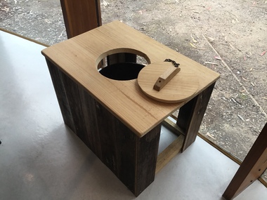
Functional object - Thunderbox, Circa 1930’s
... location are often damaged by the action of the sea and salt air. It is intimately associated with the early years of the development of the Great Ocean Road and the daily life of the workers. It is a typical example of the type of toilet used at the time. Great Ocean Road Construction Returned Sevicemen World War 1 Great Ocean Road Toll Houses Toilet This reclaimed timber thunder box is enclosed on three sides. There is a circular hole on the top with a wooden handled lid attached by a chain ...The Great Ocean Road was built by World War 1 returned servicemen. Tolls were collected as sections of the road were completed. The first toll house was at Grassy Creek. It operated from 1922 to 1932 when it was moved to The Springs at Cathedral Rock about 5 km east of Lorne. The thunderbox is believed to have been used here at sometime between 1932 and 1936This is a rare archeological find. Items n this location are often damaged by the action of the sea and salt air. It is intimately associated with the early years of the development of the Great Ocean Road and the daily life of the workers. It is a typical example of the type of toilet used at the time. This reclaimed timber thunder box is enclosed on three sides. There is a circular hole on the top with a wooden handled lid attached by a chain. Inside is a steel can.great ocean road construction, returned sevicemen world war 1, great ocean road toll houses, toilet -
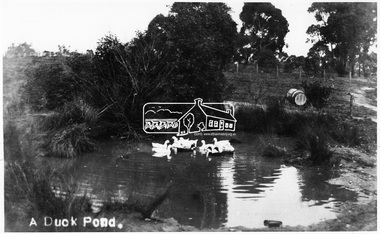 Eltham District Historical Society Inc
Photograph, Tom Prior, A Duck Pond, c.1900
... The location was Fernie Hill where Ivy Reynolds's mother was born, over from Mr Traill's property at the corner of Reynolds and Main Road, Research - used to be called 3 Chain Road, now renamed Gumtree Road. ...Eltham District Historical Society Inc 728 Main Rd Eltham melbourne The location was Fernie Hill where Ivy Reynolds's mother was born, over from Mr Traill's property at the corner of Reynolds and Main Road, Research - used to be called 3 Chain Road, now renamed Gumtree Road. ...The location was Fernie Hill where Ivy Reynolds's mother was born, over from Mr Traill's property at the corner of Reynolds and Main Road, Research - used to be called 3 Chain Road, now renamed Gumtree Road. The old Yarra River bed goes through here at top of hill in Gumtree Road. Gravel from this location was used for the driveways in Government House.This photo forms part of a collection of photographs gathered by the Shire of Eltham for their centenary project book,"Pioneers and Painters: 100 years of the Shire of Eltham" by Alan Marshall (1971). The collection of over 500 images is held in partnership between Eltham District Historical Society and Yarra Plenty Regional Library (Eltham Library) and is now formally known as the 'The Shire of Eltham Pioneers Photograph Collection.' It is significant in being the first community sourced collection representing the places and people of the Shire's first one hundred years.Digital image 4 x 5 inch B&W Negsepp, shire of eltham pioneers photograph collection, eltham, duck pond, reynolds prior collection, pond, fernie hill, gumtree road, research (vic.) -
 Bendigo Historical Society Inc.
Plan - South Frederick The Great Mine, Sebastian
... SOUTH FREDERICK THE GREAT MINE Location Unreserved Crown Land along the southern boundary of Sebastian School, east of Three Chain Road, Frederick the Great/Carshalton Reef, Sebastian Map Reference Raywood 1:25000 - BV488.447 Mine site: Capped shaft still surrounded by its mullock paddock. ...History House 11 Mackenzie Street Bendigo goldfields SOUTH FREDERICK THE GREAT MINE Location Unreserved Crown Land along the southern boundary of Sebastian School, east of Three Chain Road, Frederick the Great/Carshalton Reef, Sebastian Map Reference Raywood 1:25000 - BV488.447 Mine site: Capped shaft still surrounded by its mullock paddock. ...SOUTH FREDERICK THE GREAT MINE Location Unreserved Crown Land along the southern boundary of Sebastian School, east of Three Chain Road, Frederick the Great/Carshalton Reef, Sebastian Map Reference Raywood 1:25000 - BV488.447 Mine site: Capped shaft still surrounded by its mullock paddock. At the base of the paddock on the northern side is a concrete winding engine foundation measuring 8 by 4 feet, and standing 2 feet high. The foundation has ¾-inch mounting bolts. Battery site 70 metres to the west of the mine site are the concrete foundations of a 10head battery. The foundations measure 16 by 11 feet, and stand 4 feet high. Part of the battery's loading ramp still survives, and on the eastern side of the battery foundations is a large concrete engine foundation. Near this engine foundation is a 3 foot square concrete pad, which still retains a circular impression. Presumably this was a stand for a gas producer cylinder. Located between the battery and the mine site is a rubbish dump which contains sections of an iron stack, and perhaps the remains of the gas producer cylinder. History Period of activity: 1871 (South Frederick the Great); 1881-1889 (Amalgamated South Frederick the Great); 1897-1906 (South Frederick the Great); 1933-1937 (South Frederick the Great) Line of reef: Sebastian/Carshalton Maximum recorded annual production: unknown Total production: 511ozs obtained from 1773 tons between 1934 and 1937 Deepest working level: 300 feet (Amalgamated South Frederick the Great) Deepest shaft: 307 feet (Amalgamated South Frederick the Great)(below water level) Source: City of Greater Bendigo: Marong Heritage Study chrome-extension://efaidnbmnnnibpcajpcglclefindmkaj/http://images.heritage.vic.gov.au/attachment/70493Mining SitesTransverse and longitudinal plans on one sheet, of South Frederick The Great Mine, Sebastian. Forms part of the Margaret Roberts Collection of mining records.bendigo, margaret roberts, gold, south frederick the great mine, margaret roberts collection, sebastian -
 City of Moorabbin Historical Society (Operating the Box Cottage Museum)
Education, Pen Nibs ' R. Esternbrook Co. Ltd, 20thC
... location! To make matters worse, when putting out the fire using a human water bucket chain, someone accidentally grabbed a bucket of paraffin and set the place further ablaze. ...location! To make matters worse, when putting out the fire using a human water bucket chain, someone accidentally grabbed a bucket of paraffin and set the place further ablaze. ...Dip pens emerged in the early 19th century, when they replaced quill pens. They were generally used prior to the development of fountain pens in the later 19th century, and are now mainly used in illustration, calligraphy, and comics. A nib pen usually consists of a metal nib with capillary channels like those of fountain pen nibs, mounted on a handle or holder, often made of wood. Other materials can be used for the holder, including bone, metal and plastic. Generally speaking, dip pens have no ink reservoir; therefore the user has to recharge the ink from an ink bowl or bottle in order to continue drawing or writing. Birmingham, England was home to many of the first dip pen manufacturers. John Mitchell pioneered mass production of steel pens in 1822; prior to that the quill pen had been the most common form of writing instrument. His brother William Mitchell later set up his own pen making business in St Paul's square. The Mitchell family is credited as being the first manufacturers to use machines to cut pen nibs, which greatly sped up the process. Germany 1842 began at the factory of Heintze & Blanckertz in Berlin By 1860 there were about 100 companies making steel nibs in Birmingham, but 12 large firms dominated the trade. Dip pens are rarely used now for regular writing, most commonly having been replaced by fountain pens, rollerball pens, or ballpoint pens. However, dip pens are still appreciated by artists, as they can make great differences between thick and thin lines, and generally write more smoothly than other types of pens. Dip pens are also preferred by calligraphers for fine writing. Richard Esterbrook was a Cornish Quaker from England who saw an opportunity in the United States to manufacture Steel Pens. In 1856 R.Esterbrook traveled to the US to set up shop as 'The Steel Pen Manufacturing Company' where Richard made these steel pens by hand using special tools and machines (mostly that Richard had to invent). In 1858 he was able to establish himself as the sole pen manufacturer in the USA and he changed the company name to 'The Esterbrook Steel Pen Mfg. Co.' The company settled down in Camden, New Jersey. Quality was a key factor in his success. His steel pens were versatile, long lasting, and came in many different styles to fit the varied writing styles of the public. Sadly, Richard Esterbrook didn't see the 'empire' his company was to become as he passed away in Atlanta on October 12th 1895 . in 1896 they started an Esterbrook branch in England to join the ranks of the other main pen manufactures in Birmingham . In 1912 the company had gotten so large that they erected a 5 story building, just to continue manufacturing pens. By 1920 the fountain pen was fast becoming more popular amongst people who were tired of 'dipping.' To meet this demand the company manufactured its first fountain pen. In 1930 the company sought less expensive means of manufacturing pens because gold and 'jewel' tips were too expensive and in this same year they began selling fountain pens in England . The Esterbrook Company began using the metal Iridium which they called 'Durachrome.' To meet the fountain pen demand the company reformed as 'The Esterbrook Hazel Pens Ltd.' In 1940 war had come to strike a blow at the Esterbrook company. On November 19th 1940 their England location was hit by an incendiary bomb destroying half of the location! To make matters worse, when putting out the fire using a human water bucket chain, someone accidentally grabbed a bucket of paraffin and set the place further ablaze. Oddly enough, the company was able to rebuild the structure during the war. However, the government had placed a stipulation that 50% of its capacity was to be used for government related purposes. In 1947 the company bought out John Mitchell and the American branch had already acquired Hazel Pen Co. The company re-formed again as 'The Esterbrook Pen Company.' This is the last company name the dip pen nibs were manufactured under. A box of Steel dipping nibs for writing pensOn Box; Photo of man / R. Esternbrook Co. / PENS / PROBATEsteel nibs, writing pens, education, schools, writing, caligraphy, artists, moorabbin, bentleigh, cheltenham, dip pens, inkwells, fountain pens, mitchell john, birmingham england, esternbrook richard, maple barbara -
Ballarat Tramway Museum
Plan - Map of Greater Ballarat Residential Development. c1949, State Electricity Commission of Victoria (SECV), c1949
... location marked in orange marker. Bus routes shown in brown, green, and blue. A2 map template. Scale 1 inch = 20 chain. ...Map representation of the greater Ballarat area 1949. Created by the State Electricity Commission of Victoria (SECV), State Electricity Supply Department, Ballarat Branch.Map template used to create planning documents with association to the "Report by Hector H Bell Jnr of the Melbourne and Metropolitan Tramways Board, on the street passenger transport system of Ballaarat Urban Area".A2 map template. Scale 1 inch = 20 chain. Copy of hand drawn document. Black dye line print on beige paper. Tram and Bus routes hand drawn on print.The words "SAMPLE" and "Office Copy" written above title block of document in pencil. Print mark "P.E. 2.1" on top left corner of document. Ballarat tramway location marked in orange marker. Bus routes shown in brown, green, and blue.map, roads, secv, state electricity commission of victoria, ballarat, ballarat tramways, transport, planning -
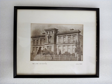 Royal Australian and New Zealand College of Obstetricians & Gynaecologists (RANZCOG)
Photograph - Reproduction photograph, Charles Nettleton (1826-1902), The Lying In Hospital, circa 1870, c. 1868
... chain and two hooks have been added to the frame for hanging. Reproduction photograph of the front of a building. The building is three stories high. The lowest floor has eight large windows, with a door at centre, on the front side. One side window can also be seen at bottom right. There is a small flight of stairs leading up to the door. The second floor has eight windows in the same locations ...This a cropped reproduction of a photograph taken by Charles Nettleton in c. 1868. Founded in 1856, The Lying-In Hospital was the second hospital to be established in Melbourne, after the Melbourne Hospital. It was, however, the first lying-in hospital in the Australasian colonies. The hospital was founded in a converted private house "Fairmont", which was located at 41 Albert Street, Eastern Hill (now East Melbourne). In 1858, the 'Lying-in Hospital' was relocated and opened in Madeline St, North Melbourne (now known as Swanston St, Carlton)." (The Women's) The building pictured here was eventually demolished in 1938 to make way for further extensions to the building. The original site in Albert Street was demolished in 1960, and the site is now occupied by the Melbourne Fire Brigade. A section of the wrought iron gates from the original site in Albert Street is held in RANZCOG's historical collection.Reproduction photograph of the front of a building. The building is three stories high. The lowest floor has eight large windows, with a door at centre, on the front side. One side window can also be seen at bottom right. There is a small flight of stairs leading up to the door. The second floor has eight windows in the same locations as the first floor, plus one additional window at centre instead of a door. The top floor is much smaller, with three small windows facing the front of the building. There are trees in the grounds in from of the building. House and grounds are enclosed behind a fence. There is a gate in the fence opposite the front door. Three figures are visible on the path outside the fence. One is at the centre of the image, and the other two are in the right-hand corner. Text printed below image reads 'THE LYING - IN HOSPITAL circa 1870'. The image has been mounted and framed in a black wooden frame. There is an old display label for this image is attached to the back of the frame. Handwritten text on backing board at back of work reads 'Probably prior to 1867 (J. Nattrass, 1968)'. Tape residue visible on backing board at upper right. A chain and two hooks have been added to the frame for hanging. Text printed below image reads 'THE LYING - IN HOSPITAL circa 1870'. The image has been mounted and framed in a black wooden frame. There is an old display label for this image is attached to the back of the frame. Handwritten text on backing board at back of work reads 'Probably prior to 1867 (J. Nattrass, 1968)'. Tape residue visible on backing board at upper right. A chain and two hooks have been added to the frame for hanging. -
 Ballarat Tramway Museum
document - Typed Notes, "Track Grades" and "Tramway Route Distances", 1953
... chains. Typed 12/3/1953, initials "WM" 2 - "Track Grades" - for Sturt St, South track between Albert and Lydiard St (south side), North side (between Courier Office and Lydiard St", Victoria St, east from Main Road, location of sharpest curve (Main Road into Barkly St), Dawson St crossover, Contained within Reg Item 5507 - Foolscap binder with green covers, black binding edge and metal clips. ...chains. Typed 12/3/1953, initials "WM" 2 - "Track Grades" - for Sturt St, South track between Albert and Lydiard St (south side), North side (between Courier Office and Lydiard St", Victoria St, east from Main Road, location of sharpest curve (Main Road into Barkly St), Dawson St crossover, Contained within Reg Item 5507 - Foolscap binder with green covers, black binding edge and metal clips. ...Yields information about the curves and grades and track distances in Ballarat on its tramways.Typed notes titled 1. - "Tramway Route Distances" detailing the distances in Ballarat over the various routes and within the city, often measured from building lines, provided in chains. Typed 12/3/1953, initials "WM" 2 - "Track Grades" - for Sturt St, South track between Albert and Lydiard St (south side), North side (between Courier Office and Lydiard St", Victoria St, east from Main Road, location of sharpest curve (Main Road into Barkly St), Dawson St crossover, Contained within Reg Item 5507 - Foolscap binder with green covers, black binding edge and metal clips. track, ballarat -
Ballarat Tramway Museum
Map, Ballarat Litho & Printing Co, "Electoral Map of Ballarat", 1920's?
... Map shows location of Showgrounds (old location), Hospital for epileptics, abattoirs, but does not show Ballarat North Railway Workshops. Title Block "Ballarat Litho & Ptg. Cos. / Electoral Map of / Ballarat / Scale 20 chains...Map shows location of Showgrounds (old location), Hospital for epileptics, abattoirs, but does not show Ballarat North Railway Workshops. Title Block "Ballarat Litho & Ptg. Cos. / Electoral Map of / Ballarat / Scale 20 chains ...Map showing the electoral boundaries of Ballarat - State? - possibly early 1920's. Has been marked up in blue pencil for electric and horse tram routes around Ballarat, along with names of terminals, depot, and other points of interest. Shows horse trams lines in Macarthur St and Armstrong St. Also has in pencil, approximate location of the railway to Buninyong. Map shows location of Showgrounds (old location), Hospital for epileptics, abattoirs, but does not show Ballarat North Railway Workshops. Title Block "Ballarat Litho & Ptg. Cos. / Electoral Map of / Ballarat / Scale 20 chains to One Inch" To be stored with minimal folding.trams, tramways, map, ballarat, horse trams -
 Marysville & District Historical Society
Photograph (item) - Black and white photograph, Unknown
... Mary-Lyn was a part of the Mary Chain of guest houses built by Eric Dowdle in the Depression years. The photograph shows a group of five men acting out a skit at an unknown location....Mary-Lyn was a part of the Mary Chain of guest houses built by Eric Dowdle in the Depression years. The photograph shows a group of five men acting out a skit at an unknown location....Mary-Lyn was a part of the Mary Chain of guest houses built by Eric Dowdle in the Depression years. The photograph shows a group of five men acting out a skit at an unknown location. ...A black and white photograph of a group of guests who were staying at Mary-Lyn Guest House in Marysville. Mary-Lyn was a part of the Mary Chain of guest houses built by Eric Dowdle in the Depression years. The photograph shows a group of five men acting out a skit at an unknown location.A black and white photograph of a group of guests who were staying at Mary-Lyn Guest House in Marysville.24 SHERRY COLLINS STUDIOS/ SAME DAY FILM SERVICE/ 81 McBRIDE AVE., WONTHAGGImarysville, victoria, australia, mary chain guest houses, mary-lyn guest house, eric dowdle, photograph -
 Marysville & District Historical Society
Photograph (item) - Black and white photograph, Unknown
... Mary-Lyn was part of the Mary Chain of guest houses built by Eric Dowdle in the Depression years. The photograph shows the group of thirteen people sitting on logs in the forest at an unknown location....Mary-Lyn was part of the Mary Chain of guest houses built by Eric Dowdle in the Depression years. The photograph shows the group of thirteen people sitting on logs in the forest at an unknown location....Mary-Lyn was part of the Mary Chain of guest houses built by Eric Dowdle in the Depression years. The photograph shows the group of thirteen people sitting on logs in the forest at an unknown location. ...A black and white photograph taken of a group of guests who were staying at Mary-Lyn Guest House in Marysville. Mary-Lyn was part of the Mary Chain of guest houses built by Eric Dowdle in the Depression years. The photograph shows the group of thirteen people sitting on logs in the forest at an unknown location.A black and white photograph taken of a group of guests who were staying at Mary-Lyn Guest House in Marysville.Marysville 24 SHERRY COLLINS STUDIOS/ SAME DAY FILM SERVICE/ 81 McBRIDE AVE., WONTHAGGImarysville, victoria, australia, mary chain guest houses, mary-lyn guest house, eric dowdle, photograph -
 Marysville & District Historical Society
Photograph (item) - Black and white photograph, Unknown
... Mary-Lyn was part of the Mary Chain of guest houses built by Eric Dowdle in the Depression years. The photograph shows the group of eleven ladies at an unknown location....Mary-Lyn was part of the Mary Chain of guest houses built by Eric Dowdle in the Depression years. The photograph shows the group of eleven ladies at an unknown location....Mary-Lyn was part of the Mary Chain of guest houses built by Eric Dowdle in the Depression years. The photograph shows the group of eleven ladies at an unknown location. ...A black and white photograph taken of a ladies cricket team who were staying at Mary-Lyn Guest House in Marysville. Mary-Lyn was part of the Mary Chain of guest houses built by Eric Dowdle in the Depression years. The photograph shows the group of eleven ladies at an unknown location.A black and white photograph taken of a ladies cricket team who were staying at Mary-Lyn Guest House in Marysville.Ladies Cricket Team/ Mary Lyn/ Marysville VELOX KODAK PRINT E 15 Flo Carstairs (Toy)/ back leftmarysville, victoria, australia, mary chain guest houses, mary-lyn guest house, eric dowdle, photograph -
Clunes Museum
Map, DEPARTMENT OF MINES, Untitled, c1859
... Clunes Museum 36 Fraser Street enter building through Collins Place Clunes goldfields All maps show names and locations of mines operating in the district (see reference section link to article) gold mining dept of mines .1 360 Scale 1:2500 .2 303/59 33 hand written in ink "received 15 October 1859" signed by R Broughton, James Stevenson - District Mining Surveyor .3 40 chains to an Inch .1 Map of Creswick Clunes - lists 45 mines in the Clunes enlargement and 100 mines in the Creswick enlargement .2 Department of Mines map of Clunes Creswick and shows the McDonald & Co. ...All maps show names and locations of mines operating in the district (see reference section link to article).1 Map of Creswick Clunes - lists 45 mines in the Clunes enlargement and 100 mines in the Creswick enlargement .2 Department of Mines map of Clunes Creswick and shows the McDonald & Co. Pre-emptive area. Indexes for quartz and alluvial mine locations .3 Topographical map Ref GF23 Clunes Mt. Greenock Talbot.1 360 Scale 1:2500 .2 303/59 33 hand written in ink "received 15 October 1859" signed by R Broughton, James Stevenson - District Mining Surveyor .3 40 chains to an Inchgold mining, dept of mines -
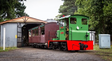 Puffing Billy Railway
NRT1, Ruston & Hornsby Diesel Locomotive, 1951
... This type of locomotive was popular in many industrial locations, with their unique clutch-less 3 speed gearbox meaning the driver could control them whilst walking alongside, a bonus when shunting. Adjustable tie rods meant that as the axles moved on the springs, they followed the radius of the drive chains, reducing the chances of chain snatch LOCOMOTIVE DETAILS NRT class No. originally constructed : No. in service : 1 No. stored: Wheel arrangement : 0-4-0DM Roadworthy weight : 9T 3cwt. ...This type of locomotive was popular in many industrial locations, with their unique clutch-less 3 speed gearbox meaning the driver could control them whilst walking alongside, a bonus when shunting. Adjustable tie rods meant that as the axles moved on the springs, they followed the radius of the drive chains, reducing the chances of chain snatch LOCOMOTIVE DETAILS NRT class No. originally constructed : No. in service : 1 No. stored: Wheel arrangement : 0-4-0DM Roadworthy weight : 9T 3cwt. ...NRT1 - Ruston & Hornsby Diesel Locomotive Built in 1951 to a gauge of 3', this Ruston diesel locomotive or rail tractor operated on the State Electricity Commission of Victoria’s Kiewa scheme. Some years later, it was regauged to 2'6" and was operated by the Melbourne & Metropolitan Board of Works. NRT1 is a Ruston & Hornsby diesel locomotive, built in England in 1951 to a gauge of 3 feet, and was initially employed by the State Electricity Commission of Victoria. It was later re-gauged to 2' 6" and ended it's working life in 1977 when it was transferred to Puffing Billy. In 1977, it was taken to the P.B.P.S. Steam Museum and stored until 1978 when it was taken to the Emerald Carriage Workshops. Later in 1983 it was returned to service as NRT1 following the V.R. classification procedure as a narrow-gauge rail tractor, but it had number plates installed and was painted Hawthorn green. It will eventually be painted the red of V.R. rail tractors with the number & class painted on in black. This type of locomotive was popular in many industrial locations, with their unique clutch-less 3 speed gearbox meaning the driver could control them whilst walking alongside, a bonus when shunting. Adjustable tie rods meant that as the axles moved on the springs, they followed the radius of the drive chains, reducing the chances of chain snatch LOCOMOTIVE DETAILS NRT class No. originally constructed : No. in service : 1 No. stored: Wheel arrangement : 0-4-0DM Roadworthy weight : 9T 3cwt. Maximum axle load : 4T 15cwt. Tractive effort (85%) : Length overall: 15' 6" Height overall: 10' Driving wheel diameter: 18" Date of manufacture: 1950 Manufacturer : Ruston Hornsby Place of manufacture: Lincoln, England Locomotive type : Diesel Mechanical Manufacturers classification : 48 DL Historic - Industrial narrow Gauge Railway - Ruston & Hornsby diesel locomotive used by State Electricity Commission of Victoria - NRT1 - Ruston & Hornsby Diesel Locomotive NRT1 - Ruston & Hornsby Diesel Locomotive made of steel NRT1 ruston & hornsby diesel locomotive, nrt1 diesel locomotive, nrt1, puffing billy -
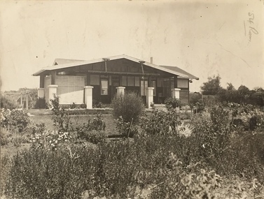 Kew Historical Society Inc
Photograph - Bungalow, probably East Kew, 1920s
... chains that are attached to the central gable. This deep gable extends across most of the façade, forming an extensive veranda. Parts of this are infilled with screens. Seven wooden posts, whose lower halves are encased in rendered brick pillars, support this gabled veranda. The roof would appear to be covered with corrugated iron. The location...chains that are attached to the central gable. This deep gable extends across most of the façade, forming an extensive veranda. Parts of this are infilled with screens. Seven wooden posts, whose lower halves are encased in rendered brick pillars, support this gabled veranda. The roof would appear to be covered with corrugated iron. The location ...The Kew Historical Society's map collection includes a substantial number of real estate subdivision plans, mainly of Kew but also of surrounding suburbs in Melbourne. Most of the subdivision plans date from the 1920s and 1930s when the districts old homes and local farmland were being split up to accommodate residential growth in the postwar period. These early plans were assembled by a local firm, Jas R Mather & McMillan, which had an office in Cotham Road. Many of the plans, and sometimes photos, were annotated by the agents.Subdivision plans are historically important documents used as evidence for the growth of suburbs in Australia. They frequently provide information about when the land was sold as well as evidence relating to surveyors and real estate and financial agents. The numerous subdivision plans in the Kew Historical Society's collection represent working documents, ranging from the initial sketches made in planning a subdivision to printed plans on which auctioneers or agents listed the prices for which individual lots were sold. In a number of cases, the reverse of a subdivision plan in the collection includes a photograph of a house that was also for sale by the agent. These photographs provide significant heritage information relating house design and decoration, fencing and household gardens.The photograph may also be aesthetically significant depending on the importance of the photographic atelier.An unusual bungalow that does not conform to a particular architectural style but which contains eclectic elements of the style of varying periods. The most striking element of the design is the cantilevered veranda that is supported by heavy chains that are attached to the central gable. This deep gable extends across most of the façade, forming an extensive veranda. Parts of this are infilled with screens. Seven wooden posts, whose lower halves are encased in rendered brick pillars, support this gabled veranda. The roof would appear to be covered with corrugated iron. The location of the house, which was advertised for sale, has to date not been identified. The real estate photo is on the reverse of a plan for the Myrtle Hill Subdivision, Kew.bungalows - kew, architecture - 1920s, real estate photographs -
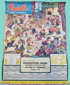 Wodonga & District Historical Society Inc
Ephemera - Pilkington's Shoe Store Calendar
... locations in High Street, Wodonga. At one stage the business provided a living for six staff, but the impact of the recession of 1982 – 83, competition from chain store discount prices and a reduced demand for high quality shoes took their toll on the business and Barry Pilkington closed his doors in 1993 after several decades serving the Wodonga community. ...locations in High Street, Wodonga. At one stage the business provided a living for six staff, but the impact of the recession of 1982 – 83, competition from chain store discount prices and a reduced demand for high quality shoes took their toll on the business and Barry Pilkington closed his doors in 1993 after several decades serving the Wodonga community. ...Len and Merle Pilkington came to Wodonga from Wonthaggi in 1946. Len had been an employee on the Victorian railways. They both gained employment with J. Mann & Son of Wodonga where Len became manager of the Shoe Department. When the Sumsion’s shoe shop became available Len and Merle bought it in partnership with Ernie Mann. The partnership dissolved a year later and Len and Merle continued as Pilkington’s Shoes. In the 1950s, the shoe repair shop belonging to Nick Hauser was up for sale and Len and Merle extended their business. In the mid-1950s they were joined by their son Barry who continued to work there in a variety of roles including shoe repairer, salesman and accountant. Over the life of Pilkington’s Shoes they operated from two different locations in High Street, Wodonga. At one stage the business provided a living for six staff, but the impact of the recession of 1982 – 83, competition from chain store discount prices and a reduced demand for high quality shoes took their toll on the business and Barry Pilkington closed his doors in 1993 after several decades serving the Wodonga community. This Calendar promoted “Paddle” shoes. Paddle Bros. Shoes Pty. Ltd. was started by Joe Paddle and his seven sons, from a small shed in Carlton. Paddle then moved to a factory in Fitzroy and later in Mornington and Ballarat. In 1982 Paddle Bros. Shoes Pty. Ltd. was purchased by Rivers (Australia) Pty. Ltd. These images and calendar are significant because they document a long standing business in Wodonga.A coloured Calendar from Pilkington's Shoe Store Wodonga advertising Paddle Shoes. It is accompanied by some black and white images of the owners and premises.Paddle Games Calendar With compliments from Pilkingtons Shoes The Friendly Footwear Store 106 High St., Wodonga Telephone: 560 Paddle for longer shoe wear - proper foot care.pilkingtons, wodonga businesses, pilkingtons shoes -
Whitehorse Historical Society Inc.
Map, Dandenong Ranges Area, 1956
... Scale: 10 chains : 1 inch. Contour intervals marked and locations of buildings. ...Scale: 10 chains : 1 inch. Contour intervals marked and locations of buildings. ...Sheet 1. Parts of Parishes: Nunawading, Warrandyte and Ringwood. Scale: 10 chains : 1 inch. Contour intervals marked and locations of buildings.Sheet 1. Parts of Parishes: Nunawading, Warrandyte and Ringwood. Scale: 10 chains : 1 inch. Contour intervals marked and locations of buildings. Compiled from aerial photographs and cadastral survey information.Sheet 1. Parts of Parishes: Nunawading, Warrandyte and Ringwood. Scale: 10 chains : 1 inch. Contour intervals marked and locations of buildings. maps, ringwood, mitcham, warrandyte -
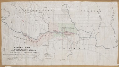 Bacchus Marsh & District Historical Society
Map, General Plan for Water Supply Works, Shire of Bacchus Marsh 1887
... locations of land held by T. (Tom) Oliver and the Racecourse Reserve in Maddingley. Scale 40 chains to 1 inch. ...locations of land held by T. (Tom) Oliver and the Racecourse Reserve in Maddingley. Scale 40 chains to 1 inch. ...Debate about water supply and its planning and development took place in the Bacchus Marsh region from the 1850s through into the twentieth century. This plan was part of documentation to support an application for an additional loan of money from the Ministry of Water Supply to the Bacchus Marsh Shire Water Supply Trust. The plan includes the route of a proposed water channel in the Parwan area, and other features of water supply infrastructure such as the location of standpipes and gates are also shown on the plan.A single page paper map showing a general plan for the supply of water in the Bacchus Marsh area.The plan shows the route of the 'Main Channel' near the Werribee River and a proposed route for a Parwan Channel. The location of 'Dryden's House' near the Werribee River is also shown and the locations of land held by T. (Tom) Oliver and the Racecourse Reserve in Maddingley. Scale 40 chains to 1 inch. The plan is signed by Bacchus Marsh Shire Engineer, W.E. Standfield. The map is pasted into a bound volume containing 76 maps or plans in total. High resolution digital image stored on BMDHS computer network. General Plan of Water Supply Works in the Shire of Bacchus Marsh. Accompanying application for 2nd additional Loan. Original Waterworks district. Additional area. W.E. Standfield, 30/8/87.water supply, water supply maps, water supply bacchus marsh, irrigation, bacchus marsh victoria maps -
 Bacchus Marsh & District Historical Society
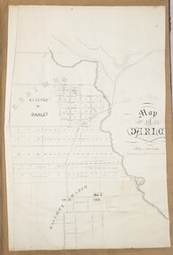
Map, 'Map of Darley' circa 1877-1897
... location suggest the map is dated between 1877 and 1897. Landholders names can be seen on some of the allotments of land marked in this map, including the names Clifton, Cosgrove, O'Hagan, McFarlane, Nagle, O'Hagan, Simpson and Vallence. Darley Victoria Maps Bacchus Marsh Victoria Maps A single page paper map showing the village of Darley and the township of Bacchus Marsh. Scale 10 chains ...This map shows the early laid out streets and roads for the village of Darley and the main roads and streets in the central area of the township of Bacchus Marsh. The date of the map is not known. Landmarks indicated on the map including the Anglican Church in Church Street (Gisborne Road), opposite the Presbyterian Church, and the Baptist Church at its pre-1898 Main Street location suggest the map is dated between 1877 and 1897. Landholders names can be seen on some of the allotments of land marked in this map, including the names Clifton, Cosgrove, O'Hagan, McFarlane, Nagle, O'Hagan, Simpson and Vallence.A single page paper map showing the village of Darley and the township of Bacchus Marsh. Scale 10 chains to 1 inch. The map is pasted into a bound volume containing 76 maps or plans in total. High resolution digital image stored on BMDHS computer network. darley victoria maps, bacchus marsh victoria maps