Showing 292 items matching "mountain creek"
-
 Kiewa Valley Historical Society
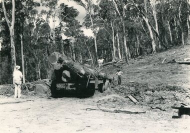
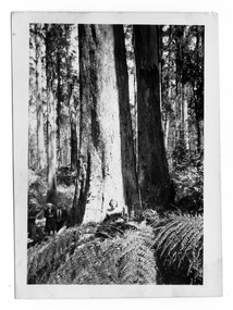
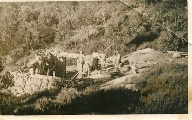
Photo - Mountain Creek Logging Camp, 1955
... Photo - Mountain Creek Logging Camp...Mountain Creek logging camp...Black and white photograph of the logging camp at Mountain Creek. November 1955...Handwritten on the back of photograph - MOUNTAIN CREEK LOGGING CAMP NOV 55...Mountain Creek, North East Victoria, Victoria, Australia...November 1955 Photo - Mountain Creek Logging Camp ...Hume and Hovell discovered the area in 1824 and by the end of the 19th century the valley was transformed by logging, dairy and beef cattle properties and tobacco farms. The logs could have been milled for timber at the State Electricity Commission's mill at Howman's Gap which provided a much needed source of timber for construction of McKay Creek Power Station which began construction in 1951 and also the camps and houses for the workers and their families. There was a need for housing and infrastructure for an increasing population of workers for the hydro-electric scheme as there was a general shortage of this commodity. A timber mill was started in Tawonga by Mates, of Albury, in 1945, and electricity became available in 1946 the S.E.C. bought the mill, and enlarged it. In 1960 it was purchase by a local family, they also started a timber mill in Mt Beauty worked both until 1980 when they closed it. The Tawonga mill and enlarged the mill called Mt. Beauty Timbers Pty Ltd employed approximately 50 people. An historical pictorial record of the general working conditions, type of machinery and vehicles in use in the 1950’s. Note the lack of protective clothing!Black and white photograph of the logging camp at Mountain Creek. November 1955Handwritten on the back of photograph - MOUNTAIN CREEK LOGGING CAMP NOV 55mountain creek logging camp, timber industry, tawonga -
 Kiewa Valley Historical Society
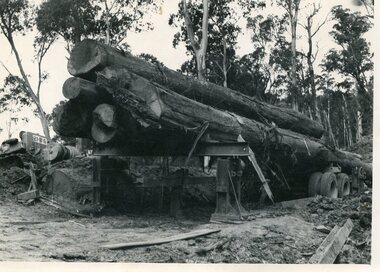
Photo - Logging. Mountain Creek, November 1955, November 1955
... Photo - Logging. Mountain Creek, November 1955...Mountain Creek logging camp...Black and white photograph of logging at Mountain Creek November 1955...Small typed note attached to the back of photo - Logging Mountain Creek November 1955...Mountain Creek, North East Victoria, Victoria, Australia...Mountain Creek, November 1955 ...Hume and Hovell discovered the area in 1824 and by the end of the 19th century the valley was transformed by logging, dairy and beef cattle properties and tobacco farms. The logs could have been milled for timber at the State Electricity Commission's mill at Howman's Gap which provided a much needed source of timber for construction of McKay Creek Power Station which began construction in 1951 and also the camps and houses for the workers and their families. There was a need for housing and infrastructure for an increasing population of workers for the hydro-electric scheme as there was a general shortage of this commodity. A timber mill was started in Tawonga by Mates, of Albury, in 1945, and electricity became available in 1946 the S.E.C. bought the mill, and enlarged it. In 1960 it was purchase by a local family, they also started a timber mill in Mt Beauty worked both until 1980 when they closed it. The Tawonga mill and enlarged the mill called Mt. Beauty Timbers Pty Ltd employed approximately 50 people An historical pictorial record of the general working conditions, type of machinery and vehicles in use in the 1950’s. Black and white photograph of logging at Mountain Creek November 1955Small typed note attached to the back of photo - Logging Mountain Creek November 1955mountain creek logging camp, tawonga, timber industry -
 Falls Creek Historical Society
Clothing - Shirt Falls Creek Mountain Bike Park Crew
... Shirt Falls Creek Mountain Bike Park Crew... Shirt Falls Creek Mountain Bike Park Crew...Falls Creek Mountain Bike Park...The Falls Creek Mountain Bike Park opened in 2013 with 40 kilometres of trails in the Victorian Alpine National Park. ...A uni-sex style shirt designed to be worn by mountain bike crews in Falls Creek, Victoria. It has multi-coloured panels of black, orange, yellow and grey. ...On front: PARK CREW/ DHARCO On back: Falls Creek Mountain Bike Park On both sleeves: PARK CREW...The Falls Creek Mountain Bike Park opened in 2013 with 40 kilometres of trails in the Victorian Alpine National Park. ...The Falls Creek Mountain Bike Park opened in 2013 with 40 kilometres of trails in the Victorian Alpine National Park. Designed and built by World Trail, the bike trails provide access to beautiful alpine terrain. The rides now extend over more than 50 kilometres, catering for a range of abilities and providing activities in the summer season. All trails start and finish in the resort. The high-altitude trails of Falls Creek include a range of wide gravel roads to winding single trails. The graded trails include rides to the Rocky Valley Lake, historic cattlemen’s huts such as Cope Hut and Wallaces Hut, the top of Mt McKay, Pretty Valley Lake and for the experts the ride to Mt Nelse and the Spion Kopje summit. MTB Bike Patrol Top To ensure rider safety, Falls Creek Resort introduced a Bike Patrol service during shuttle operating hours. Many Ski Patrol members transitioned into these roles, offering riders peace of mind that medical care was available quickly if needed. The program highlighted the resort's commitment to duty of care and to growing mountain biking responsibly. This shirt was designed by Australian Company Dharco as a highly visible uniform for crew at the Falls Creek Mountain Bike Park. Jo Prothero, Director of Marketing for Falls Creek Resort Management from 2012 to 2019, generously donated two mountain bike jerseys that capture a pivotal era in the resort's history. During Jo's tenure, the resort made significant investments in mountain bike trails, aiming to activate the village during the summer months and support local businesses. This development included appointing Blue Dirt as the resort's first shuttle operator, transporting riders from Howman's Gap to the Summit.This shirt is significant as it is representative of the Falls Creek Mountain Bike Park development.A uni-sex style shirt designed to be worn by mountain bike crews in Falls Creek, Victoria. It has multi-coloured panels of black, orange, yellow and grey. It features an image of a mountain biker descending a slope on the front along with the manufacturer's name. Sponsors' logos also feature across the lower backOn front: PARK CREW/ DHARCO On back: Falls Creek Mountain Bike Park On both sleeves: PARK CREWfalls creek mountain bike park, falls creek staff uniform -
 Federation University Historical Collection
Document, Zelda Martin, Central Victorian Goldmining towns - Boom Towns or Ghost Towns?, c1996
... ...Mountain Creek...List - Names and Occupations *Moliagul Victorian Post Office Directory 1868 - Name / Ocupation / Address / Comments *"The Welcome Stranger" gold nugget *The Sunday School *The Welcome Stranger Discovery Walk - information and map Moonambel (Mountain Creek) Redbank *Brief History *List of names extracted from advertisments of the Pioneer and Mountain Creek Advertiser 16/02/1861. ...List - Names and Occupations *Moliagul Victorian Post Office Directory 1868 - Name / Ocupation / Address / Comments *"The Welcome Stranger" gold nugget *The Sunday School *The Welcome Stranger Discovery Walk - information and map Moonambel (Mountain Creek) Redbank *Brief History *List of names extracted from advertisments of the Pioneer and Mountain Creek Advertiser 16/02/1861. ...Zelda Martin was a PhD candidate at the University of Melbourne.[.1] 4th item in light blue display book titled Research Approach/Overview of Chapters/Confirmation of Canditure/Chapters1,2,3&4 of proposed thesis. *Twenty-seven page article on Victorian goldfields towns titled: Central Victorian Goldmining Towns - Boom Towns or Ghost Towns. The article was written during the author's PhD study. It outlines the context methodology, and resources and the chapters of the proposed thesis: (1) Central Victorian Goldmining Towns - The Context (2) Contemporary Views of the Factors Necessary for Town Growth (3) Outward Manifestations of Town Growth (4) The Trappings of Government (5-9) The Main Towns and Their Hinterland. [.2] 5th item in Light Blue display book as above item. *Chapter 1 of proposed thesis titled 'Pick, Shovel and Tin Dish Mining.' Covers in Section A: Central Victoria - Pre 1851: Aborigines in Central Victoria, Squatters, and Government. Section B: The years 1851-1854: The Early Gold Rushes, Government Reaction, Township Surveys, Legislation, Town Development, Local Government and Early Settlement. [.3] 6th item in Light Blue display book as above item. *2A of proposed thesis titled 'Contemporary Views of the Factors Necessary for Town Growth'. Similar information to Chapter 1 plus extra re towns and maps. Sections: Introduction, Context of Place - Geographical Towns Listed, The Context of Time - Pre1851 Aborigines, Governance of Port Phillip, The Squatters, The Villages of Central Victorian Highlands, Conclusion, Condensed Version of Chapter2B. [.4] 7th item in Light Blue display book as above item. *Chapter2B of proposed thesis. Sections: Area of Research, Schools, Banks, Newspapers, Progress Association, Town Development - Sandhurst (Bendigo), Ballarat, Castlemaine,, Maryborough, Ararat and Stawell. [.5] 8th item in Light Blue display book as above item. *Chapter 3 of proposed thesis titled 'Outward Manifestations of Town Growth'. Sections: Introduction, Contemporary Writing, Educationalists, The Bankers, The Townsfolk, Current Theory, General Theories of Urban Development, and Conclusion. [.6] 9th item in Light Blue display book as above item. *Chapter 4 of proposed thesis titled 'Trappings of Government' Sections: Introduction, Early Government Attitudes to Mining and Town Development, Law and Order, Township Surveys, Legislation, Local Government, Transport and Communication, The People and Lobbyists. [.7] 10th item in Light Blue display book as above item. *'The Rise and Fall of Central Victorian Goldmining Towns'. Includes a map showing main Goldfields, a table showing towns and villages at two points in time - 1857 and 1871; a Bibliography of Primary and Secondary Sources. [.8] Resource No1. Black display book titled Local Towns 1 : Alma: *Brief history *Directory *Maps Amphitheatre / Mountain Hut: *Brief History Post Office Directory Ararat: *Brief History *Post Office Directory 1869 - Alphabetical Listing by Occupation *Ararat - Prominent Citizens of 1858 *Langi-Morgala Museum Avoca: *Brief History *Excerpts from 'Avoca The Early Years', Margery and Betty Beavis; pg1 - Beginnings; pg11 - The Midas Touch; pg25 - Local Gold Escorts; pg27 - A Town is Born; pg51- The Administration of Justice; pg53 - The Ways of the Law; pg61 - News of the Day; pg65 - A Time to Play; pg72 - Land Ownership *Post Office Directory (Bailliere's) 1869 *Tourism Map and Information of area *Historic Avoca - A 5.5km Tour *Avoca & the Pyrenees Region - information pamphlet Ballarat: *Early History of Ballarat - Ballarat Historical Society, Publication No.1: origin of the name; Ballaarat - the Beginning; Fabulous Yields from the Ballaarat Goldfield; *Streetscape Lydiard Street. *Hand drawn map showing Leigh River, Old Portland Bay Road, plaque on road to Colac; etc. *Newspaper article re 'The Theatre Royal' ( which stood in the vicinity of the current Owen Williams store) - 'The News'15/04/1998 *Article - 'Ballarat's Mechanics' Institute Lives On' Ballarat Courier, 14/09/1985 *Article - Standing the Test of Time' The News 17/11/1993 re The Mechanics Institute & picture of the Reading Room *'Ballarat a Study of a City, Phyllis Reichl, pub. Nelson, 1968; no.3 place, time and people field studies series *Investigator Vol.33 No.2, 1998 Geelong Historical Society. Article on pg75 describes Ballarat in 1861 *Folded poster - 'Ballarat 100' a history of telegraph communication, pub. Telecom. Beaufort (Fiery Creek): *Brief history *Post Office Directory [.9] Resource No.2 Black Folder Titled Towns cont.No2 Bendigo (Sandhurst): *'Family & Local History at the Bendigo Library - 1851-2001 150 years of gold'. *Bendigo Government Camp in 1853 illustration; key to sketch and names of Government officers stationed there *Excerpts from 'Bendigo and Vicinity' Adolph Haman *The Bendigo Goldfield Registry - pgs 1-7 Introduction *Excerpt: 'Breaking the Grip' *Excerpt: The Most Go-Ahead Place *Excerpts from 'History of Bendigo' - anti license agitation; laying out of town; proposed railway; gold calls and dividends; the Sandhurst Municipality; journalism *Bibliography Blackwood: *Excerpts from 'Aspects of Early Blackwood - The Goldfield, the Landmarks, the Pioneers' Alan J Buckingham and Margaret F Hitchcock, JG Publishing,1980 Buninyong: *A Brief History *Investigator Vol1 No.2 Feb 1966 Geelong Historical Society. Pg3 - Article re gold escort route - Mt Alexander to Adelaide - (see a simple monument on the Western Highway a few miles out of Horsham. Pg 15 - Ballarat Excursion - re the finding of gold. *Three articles published by Buninyong and District Historical Society Inc: (Magpie Exploration; Finding Gold In The Green Hills; Magpie Exploration; Burnt Bridge to Cargarie to Mt Mercer) *Copies of newspaper articles/items *Buninyong Street Directory Carisbrook: *In the Beginning There Was Carisbrook *The History of the Carisbrook Racecourse Carngham / Snake Valley: *Brief History *Directory Castlemaine: *Directory 1865-1866 - Alphabetical and Street *Poster - Castlemaine A Contemporary Guide "The Great Centre" 1866 - A Contemporary Guide to the Fascinating Past *Pamphlet - Castlemaine District Community Hospital *Map - Castlemaine, Maldon & Surrounding Districts *Map and Information - The Dry Diggings Track - a 55kl walk among historic goldfields relics ( Castlemaine Fryerstown Vaughan Mt Franklin Hepburn Daylesford) *Postcard - Former Court House *Directory 1867 - Alphabetical, Trade [.10] Resource No.3 Grey folder Titled Towns 3 Creswick to Maryborough Creswick: *Brief History *Booklet - "Creswick Cemetery Walk" *Booklet - The Buried Rivers of Gold Heritage Trail Creswick *Creswick Historical Museum Information Sheet *Chronological History of Creswick *Alphabetical Directory of the Borough of Creswick *Creswick's Creek Directory 1856 *Historic Creswick Walking Tour *A Brief Account of the Schools of Creswick - Past and Present *100 Years of Railway Travel in Creswick *The Berry Deep Leads *The Spence Home at Jackass Gully in the Creswick State Forest ( William Guthrie Spence - Pioneer) *The New Australian Mine and the 1882 Disaster *Creswick District News, Issue 7, July August 1999 *The Creswick Miners Walk - Information and Map *Maps Chewton: *Brief History *Directory Clunes: *Brief History *Clunes Street Directory Daylesford: *Brief History *Notable Bushfires in Daylesford District Over More Than a Century - "Black Thursday" 1851; 1862; 1899; the Disastrous Hepburn Fire of 1906; 1939; 1944; 1969. *Post Office Directory -Daylesford and Hepburn Dunolly / Inkerman: *Brief History *Directory *Pamphlet - Goldfields Historical Museum *Pamphlet - Historic Dunolly - Victoria's Best Kept Secret *Map of Gold Workings at Dunolly Area - showing where the main gold rushes occurred *Brief History - Inglewood *Directory - Inglewood - Name Occupation, Dwelling Kingower: *Brief History *Directory - Name / Ocupation / Dwelling Linton / Happy Valley / Piggoreet: *Brief History *Directory - Lintons McIvor: *"A History of the Shire and the Township of Heathcote" by J.O. Randell Majorca: *Brief History *Official Post Office Directory 1869 - Name / Occupation/ Address Maldon (Tarrangower): *Brief History Part 1 *Brief History Part 2 *Post Office Directory *List - Alphabetical Order by Names plus Business and Trade (Tarrangower Times Oct/1858) *List - Alphabetical Order by Trade plus Name and Business *Directory - Name / Occupation / Dwelling Maryborough: *Worsley Cottage - built by Arthur Worsley, a contractor in stonework in 1894 [.11] Resource No. 4 Blue Display Book titled Towns 4 Moliagul to Stawell Moliagul: *Brief History *Moligul Legislative Assembly (Voting?) List - Names and Occupations *Moliagul Victorian Post Office Directory 1868 - Name / Ocupation / Address / Comments *"The Welcome Stranger" gold nugget *The Sunday School *The Welcome Stranger Discovery Walk - information and map Moonambel (Mountain Creek) Redbank *Brief History *List of names extracted from advertisments of the Pioneer and Mountain Creek Advertiser 16/02/1861. *Bailliere's Directory 1869 - Alphabetical List of Name / Occupation / Place St Arnaud: *Brief History Sebastapol: *Brief History *Directory 1869 - Alphabetical by Name; plus occupation and address. Browns and Scarsdale: *Brief History *Browns Street Directory - Name and Occupation Smythesdale: *Brief Description *Smythesdale Street Directory -Name and Occupation Stawell (Pleasant Creek) *Brief History *Victorian Official Post Office Directory - Name /Occupation / Dwelling *Chronology - 1841-1920 *Production of gold statistics - 1879 - 1900 *Big Hill *Extracts from "The Golden Years of Stawell". Chapt 1 - Stawell's Coming Out. Capt. 2 - The Gold Rush. Caapt.3 - Cradle of Democracy. Chapt.4 - The Reefs Becomes Stawell. Chapt. 5 - Rushing In. Chapt.6 - The Pioneers. Chapt 7 - The Decade of Optimism. [.12] Resource No. 5: Blue Display Book titled 'Towns Steiglitz to the The Golden Triangle. Steiglitz: Brief History Victorian Post Office Directory 1869 *Map of Steiglitz *List of maps relevant to Steiglitz history *Information 6 tables of data from "Reports of Mining Surveyors Talbot (Back Creek) Brief History Taradale: Post office Directory 1869 - Name/Occupation/Street. Also list in alphabetical order by Occupation Taradale *Chronological Reference to Taradale Mines *Water - The Coliban System of Waterworks *Joseph Brady *The Syphon Tarnagulla (Sandy Creek) *Brief History *Tarnagulla Businessmen Cameos to give depth to advertisments in 'The Tarnagulla Courier' various issues 1864-1871 *Directory - Name/Occupation /Address *List - Name/Business/Trade Wedderburn (Koorong) *Brief History *List - Name/Occupation The Golden Triangle: *The Early Rushes - Wedderburn / Moliagul / Sandy Creek - Tarnagulla / Jones Creek - Waanyarra / Kingower / Dunolly - Goldsborough / Inglweood *Census of 1857 - Population / Occupations *1858-1871 - A Time of Consolidation- Wedderburn / Moliagul / Sandy Creek- Tarnagulla / Arnold *Census 1871 - Population *Information gleaned from the census data - Demographics / Population / Occupations / marital / Birthplace / Religion / Literacy/ Occupation and Housing Cameos *Graphs - Birthplace of settlers /Male-Female Ratio / Married males / Children under 15 as Percentage of Population / Religion *Census 1857 - Statistical data *Maps *Bibliography [.13] Resource No. 6 - Black Display Book Information and Research in Central Victoria including: *Banking - Research from ANZ Bank Archives *Institutions - also includes articles listed from the Ballarat Times Newspaper *Australian mining History Association - A.M.H.A. Bibliography *Australia's Mining History * Bibliography - Land Surveys Victoria - *1853 Administration (Statistics and Other) includes: schools / ministers of religion / police / military / local administration / licences for sale of spirits / distances between various Victorian gold fields. * Victoria Government Gazette (Copy) - N0. 116, 12/12/1854 includes: Gold Felds Commission of Enquiry & No. 85, 15/09/1854 - Addresses presented to the Lieutenant Governor (Sir Charles Hotham) during his tour through the Gold Fields of Victoria,1854. Addresses on behalf of : the people of Bendigo; Members of the Church of England, Bendigo; Members of the Wesleyan Church on the Bendigo Gold Fields; Bendigo Gold District General Hospital; the Bendigo Prospecting Association; Committee of the Bendigo Local Exhibition; Bendigo District Medical Association; Coloured Americans Resident at Bendigo; German Inhabitants of Bendigo; Landowners, Inhabitants, and Miners of Castlemaine; Inhabitants of Forest Creek; Inhabitants of Heathcote and Gold Miners of McIvor; Residents and landholders of the District of Bacchus Marsh; Inhabitants of Kilmore and Vicinity. *Gold Fields Correspondence 1853: letter from Lieutenant Colonel Valiant, (Officer commanding the Troops in Victoria) to the Lieutenant Governor re threatened disturbance at Sandhurst (Bendigo) regarding the Gold License Fee. * Extracts from a book "Victoria" re Gold Fields Commission of Enquiry involving mainly Ballarat and Castlemaine and a chapter titled 'A Tour to the Victorian Gold-Fields' *Lists of central Victorian newspapers - listed by date published 1851to 1874; by first date available to State Library. *A list of cities and towns showing County, population in 1861 &1871, and municipal status. [.14] Resource no.7. Black display book. *Reference: Papers presented to Parliament Victoria - 1859-1860 4 volumes - relevant sections copied. Contains information on Branches of Government. General / Finance / Gold / Gazette / Commission and Warrant / Statistic. *Gold Fields Act. In accordance with the Act the gold fields are divided into six districts - Ballaarat, Castlemaine , Sandhurst, Avoca, Ararat, and Beechworth.. Official staff in each gold district consists of a Resident Warden, Wardens, Wardens' Clerks, Bailiffs, Chinese Protectors, Chinese Interpreters, and Mining Surveyors. *Gold Receiver *Gaols *Police magistrates and Clerks of Petty Sessions, etc. *Field Branch *Immigration and Emigration Overland - Chinese - 1859 *Population on the Goldfields *The Geological Survey - The Government Geologist is assisited by staff from four branches - the office Branch; the Publishing Branch; the Field Branch and the Museum Branch. *Commission to Enquire Into Sludge dated 10/02/1859 (Some sections copied) - Report to the Honorable Chief Commissioner of Public Works, Melbourne re the mode of carrying the sludge from the puddling mills in Sandhurst without interfering with the drainage of the town and the roads in the neighbourhood. [.15] Resource No.8: Camel display book titled Resource No. 8. Aborigines *Lists of book titles - +"Readings in Victorian prehistory" +"The Aborigines of Port Phillip" +Aboriginal languages and clans" +"A History of the Port Phillip District" +"Langi Ghiran 1: Aboriginal Rock...." +"Koorie History: sources for aboriginal studies in the State Library of Victoria", ed. Tom Griffiths, Melb. Friends of the State Library, 1989 +"The Public Lands of Australia Felix"; settlement and land appraisal in Victoria1834-91 with special reference to the Western Plains", J.M.Powell, Melb. Oxford University Press 1970 +*Bibliography of the Victorian Aborigines' from the earliest manuscripts to 31st December 1970, Massoa, Aldo, Melb. Hawthorn Press, 1971 +"Aborigines in Colonial Victoria, 1836-1886", M.F. Christie, Sydney University Press, 1979 +"Urban and Industrial Australia: readings in Human Geography" ed J.M. Powell, Melb. Sorrett Pub. 1974 *Extracts: -Processes of Pioneer Settlement - The Squatting Occupation of Victoria, 1834-60. J.M. Powell -Areal Variations in the Class Structure of the Central-Place Hierarchy. P. Scott - Volume1 and Volume 2: Notes Relating to the Habits of the Natives of Other Parts of Australia and Tasmania. Compiled from various sources for the Government of Victoria by R Brough Smyth. John Curry, O'Neil, Melb. 1st pub. Melb. 1876. p31-45 - Numbers and Distribution of the Aborigines in Victoria -Victorian Aborigines 1835-1901 - A Resource Guide to the Holdings of the Public Record Office, Victoria; published by the Government Information Centre 1984. *History of the Aboriginal Artefacts Displayed in the Daylesford Museum. F. G. Powell (4 page pamphlet) *Letter to Zelda Martin from Peter Lovett, Cultural Officer, Ballarat & District Aboriginal Co- Operative, 05/02/1997 *Map: Ian Clarke Victorian Tribunal Boundary Map - Clans of Central Victoria. *Victorian Rock Art and Mythology - Article about Mount Langhi Ghiran and myths of the Tjapwarong people. *Two Aboriginal myths relating to the Grampians - 'The Monster Emu' / 'The Aquisition of Fire', by the Aborigines in the Grampians Areas *Article titled (chapter 8) Ballarat - information re camping sites in the region. Lake Wendouree / Lake Burrumbeet (includes a myth) / Mt Bunninyong / Lal Lal / Pitfield / Mount Elephant / Mount Egerton / Meredith / Lake Goldsmith / Lake Learmonth / Ercildoune *Notes on the Aborigines of the Wider Ballarat Region plus European names=Aboriginal names. John Morris 26/07/1995 *Role of Aborigines in Town Development in Central Victoria. Mentions Native Police Force est. in Port Phillip 1842 and Central Board for Aborigines est. 1860 *The Grave of King Billy. (Frank Wilson) Pamphlet. *Camping Places in Central and Northern Victoria. Article re Lake Burrumbeet site. *Programme for the Unveiling of Memorial Cairn for Edward Stone Parker 1802-1865. Note portrait not accurate. Accurate portrait is available in the book "A Successful Failure A Trilogy The Aborigines and Early Settlers", Edgar Morrison, Graffiti Publications, 2002. * Large envelope addressed to Mr G Netherway containing newspaper cuttings regarding the life of Edward Stone Parker, the unveiling of the Memorial Cairn as mentioned above, articles titled 'Episodes from Our Early Days' (Edgar Morrison, Yandoit)- The Black's School, A School At Last and The Final years. Also a typed page titled 'Historical Background to E.S.Parker's Career. Includes an interesting tale titled 'When the cat lay doggo' re laying power leads for the unveiling ceremony at the memorial site. [.16] green display folder titled 'Research Aids' *List of references to Commissioners' & W'ardens' Reports (formerly held at La Trobe Library Archives, now at Public Records Office [PRO]). Indicates town referred to / date of report / name of camp if different to town. * Archive information re Anglican Records *Movement around the Goldfields - Miners and Storekeepers - usefulness of newspapers in providing information - areas covered - Castlemaine, Maldon, Ararat, Stawell, Tarnagulla, Dunolly. *Port Phillip /Victoria Directories 1839/1867 - Chronological list of Directories included in this series. *"Notes on the History of Local Government in Victoria" A.W. Greig Melb. University Press 1925 - Photo-copied extract p5-p40. (Source - Deakin University Library) - Introduction by W.Harrison Moore. Section 1 - Development in New South Wales Before Separation. Section 2 - Development in Victoria After Its Separation from New South Wales. Hand written notations: 'roads, markets, and local government 1855 on' ;'opportunity of squatters in parliament' and 'opportunities of matters in parliament p33' * Notes on the Establishment of Surveyor General's Department 1851and Commissioner of Crown Lands and Survey. * Newspaper articles from The Argus, 1849, re the discovery of gold in the Pyrenees region. * Excerpt - a report on schools - A.B.Orlebar, Inspector; re the need for permanent school buildings rather than tents. *Excerpt from - 'Approaches to Urban History', Sean Glynn: The Case for Caution * Except from - 'The Urban Sprinkle', Weston Bate: Country Towns and Australian Regional History *Reference- 'The History of Land Tenure in the Colony of Victoria', John Quick. References the Haines Land Bill, land tenure and Land Leagues. [.17] Light blue envelope folder titled 'Birtchnell's Ballarat, etc. Directory 1862 *Contains various directories for Smythesdale, Buninyong, Clunes, Brown's and Creswick. [.18] Red envelope folder no.2 titled Victorian Gazetteer *Selected pages from 1869 Victorian Gazetteer on A4 paper (with a handwritten note questioning if some pages are from 1868 Victorian Gazetteer as appears to be different sizes - A3 pages.) Information includes locations and descriptions of towns, hotels, banks, communications and populations. (Does not include names, residences and occupations) [.19] Red Envelope folder titled Bailliere's Official Post Office Directory 1868 (or1869 or a mixture of both?) *Preface *Contains a selection of pages of towns highlighted in yellow in the the index *Work on this directory was commenced in 1867. *Information includes: Municipalities - mayors and councilors; lists of towns naming male inhabitants and their occupations. [.20]Yellow manila folder titled Post Grad Seminar Presentation 1996 *Gives some background to Zelda Martin's proposed thesis and why she chose the topic Gold Mining Towns Boom or Bust [.21] A3 display book - No. 1A * A list of 'Relevant Newspapers collected: The Tarrangower Times and Maldon Advertiser (first published 1858) Includes dates 1858-1867. The Mount Alexander Mail. Includes dates 1854-1866 The Tarnagulla Courier. Includes dates from1864-1871 Dunolly and Burnt Creek Express. Includes dates from 1862-1871 * Selection of newspaper pages from The Mount Alexander Mail 1854 to 1856, mostly showing advertisements for businesses and services provided to that community. [.22] A3 display book - No. 1B * Selection of newspaper pages from The Mount Alexander Mail 1857 to 1866, mostly showing advertisements for businesses and services provided to that community. [.23] A3 display book -No. 2 * Selection of newspaper pages from The Tarnagulla Courier 1864 to 1871, mostly showing advertisements for businesses and services provided to that community. [.24] A3 display book - No. 3 *Selection of newspaper pages from The Tarrangower Times (and Maldon and Newstead) Advertiser 1858 to1867, mostly showing advertisements for businesses and services provided to that community. [.25] A3 display book - No.4 * Selection of newspaper pages from The Dunolly and Burnt Creek Express; and The Dunolly and Betbetshire Express 1862 to 1871, mostly showing advertisements for businesses and services provided for that community. [.26] A3 display book - No.5 Includes: * Bryce Ross's Diggings Directory. Includes instructions for using this directory. This directory was used by "all persons having connexion or desiring to communicate with 'working parties, private friends, or Stores at the Diggings." As a directory for each area wwas completed it was published in each month's issue of Bonwick's "Digger's Magazine." Years c1852/1853. This Directory commences first at the head of Forest Creek. Includes a directory for Bendigo and Ballarat. Of interest at the end of the Bendigo and Ballarat directory is a list of the number of storekeepers, butchers, doctors, smiths, eating houses, lemonade sellers and chapels. * The Castlemaine Directory and Book of General Information Comprehending Glass's Model Calendar for the Two Years 1862 and1863. "zelda martin, victorian goldfield towns, bendigo, castlemaine, ballarat, maldon, stawell, ararat, maryborough, creswick, avoca, heathcote, banks, bank of australasia, union bank of australia, government camp, sandhurst, water supply, tarnagulla, talbot, back creek, mountain creek, police court, carisbrook, dunolly, thompson's foundry, charles clacy, anthony trollope, robert cecil, mount alexander, urbanisation, national schools, education, govenrment, industry, railway, transport, settlement, land settlement in central victoria, steiglitz, joseph brady, the new australian mine, berry deep leads, william guthrie spence, creswick state forest, arthur worsley, worsley cottage, the welcome stranger, moliagul, moonambel, redbank, st arnaud, sebastapol, brown's, scarsdale, clunes, chewton, daylesford, bushfires, inkerman, inglewood, kingower, lintons, happy valley, piggoreet, mcivor, majorca, tarrangower, taradale, the coliban system, the syphon, sandy creek, wedderburn, koorong, arnold, jones creek, waanyarra, the golden triangle, census 1857, blackwood, buninyong, durham lead, magpie, carngham, snake valley, alma, amherst, daisy hill, amphitheatre, mountain hut, beaufort, fiery creek, counties, population, gold fields commission of enquiry1854, william westgarth, gold license fee, lieutenant colonel valiant, administration of the victorian gold fields, commission to enquire into sludge 1859, e.s. parker, edward stone parker, edgar morrison, mount franklin protectorate, dja dja wurrung, memorial cairn, franklinford, mt franklin memorial cairn, jajowurrong, dja dja wurung, tjaowarong, wothowurong, assistant protectors, daylesford museum, buluk, rock art - grampians, aboriginal mythology - grampians, aborigines, first nations people, mount franklin, aboriginal artifacts, lake burrumbeet, native police force, central board of aborigines, yandoit, commissioners' reports, wardens' reports, port phillip/victoria directories 1839-1867, local government - victoria 1853/1854, surveyor general's department - 1850's, victorian schools 1850's, a.b.orlebar, haines land bill, william charles haines, wilson gray, land tenure, land leagues, victorian gazetteer, the tarrangower times and maldon advertiser - 1858-1867, the mount alexander mail 1854-1866, the tarnagulla courier 1864, dunolly and burnt creek express 1862-1871, bryce rose's diggings directory, the castlemaine directory 1862-1863 -
Federation University Historical Collection
Document, Zelda Martin, Confirmation of Candidature - Central Victorian Towns - Boom or Bust, c1996
... ...Mountain Creek...Zelda Martin Victorian goldfield towns bendigo castlemaine ballarat Maldon Stawell Ararat maryborough Creswick Avoca Heathcote Banks Bank of Australasia Union bank of Australia government camp Sandhurst water supply Tarnagulla Talbot back creek Mountain Creek Police court Carisbrook dunolly thompson's foundry Eleven page article on Victorian goldfields town. ...Zelda Martin was a PhD candidate at the University of Melbourne. Zelda had a Bachelor of Commerce (majoring in Economic History and Economic Geography), an Master of Arts (in Politics) and a Diploma of Education; all from the University of Melbourne. Zelda is the author of a book titled " Australia's Relations with the Third World in the context of negotiations for a new international commodity order in the 1970's: continuity or change?" Pub. [Parkville, Victoria]: University of Melbourne, 1982.Eleven page article on Victorian goldfields town. The article was written during the author's PhD study. zelda martin, victorian goldfield towns, bendigo, castlemaine, ballarat, maldon, stawell, ararat, maryborough, creswick, avoca, heathcote, banks, bank of australasia, union bank of australia, government camp, sandhurst, water supply, tarnagulla, talbot, back creek, mountain creek, police court, carisbrook, dunolly, thompson's foundry -
Koorie Heritage Trust
Book, Beavis, Margery et al, Pioneers of the Pyrenees, 1984
... Avoca Shire - History - Pyrenees - Natte Yallock - Homebush - Lamplough - Mountain Creek - Moonambel - Percydale - Redback...Koorie Heritage Trust Levels 1 & 3, Yarra Building Federation Square, Melbourne melbourne Avoca Shire - History - Pyrenees - Natte Yallock - Homebush - Lamplough - Mountain Creek - Moonambel - Percydale - Redback 12-149; maps; figs; index; footnotes; 27 cm. ...12-149; maps; figs; index; footnotes; 27 cm.avoca shire - history - pyrenees - natte yallock - homebush - lamplough - mountain creek - moonambel - percydale - redback -
 Kiewa Valley Historical Society
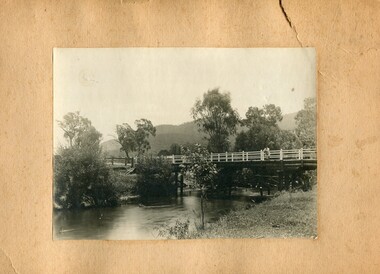
Photographs- 1 old black and white photograph of a wooden bridge over a river possibly Ryders Bridge in Tawonga. 2 –Enlargement of the original photograph showing the gentleman leaning on the bridge. Taken off the original photo
... Circa 1930”s and may be Ryders Bridge (Old Tawonga Bridge) which crosses the Kiewa River on Mountain Creek Rd Tawonga The first Tawonga bridge was built in 1884- destroyed by floods in 1916. ...Circa 1930”s may be Ryders Bridge (Old Tawonga Bridge) which crosses the Kiewa River on Mountain Creek Rd Tawonga ...Circa 1930”s and may be Ryders Bridge (Old Tawonga Bridge) which crosses the Kiewa River on Mountain Creek Rd Tawonga The first Tawonga bridge was built in 1884- destroyed by floods in 1916. ...The bridge is not definitively identified, but is of similar construction style to other bridges built in rural areas around this time. Circa 1930”s and may be Ryders Bridge (Old Tawonga Bridge) which crosses the Kiewa River on Mountain Creek Rd Tawonga The first Tawonga bridge was built in 1884- destroyed by floods in 1916. New bridge constructed 1923 and destroyed in 1953. Present concrete bridge constructed in 1986 and named Ryders Bridge These wooden bridges were the only method for transporting stock and produce to market, transporting timber to the mills, sending and receiving mail and for local people to cross the many rivers in the area to go about their daily business. 1- Black and white photograph is glued onto heavy cardboard, which is yellowing with age. Top right hand corner has a tear in the cardboard. Photograph depicts a wooden bridge on wooden piles with 2 white wooden railings along the length of both sides. 2- Original photo has been digitally enlarged to show a gentleman in a light coloured suite and wearing riding boots leaning on the rails of the bridge. The bridge is not definitively identified, but is of similar construction style to other bridges built in rural areas around this time. Circa 1930”s may be Ryders Bridge (Old Tawonga Bridge) which crosses the Kiewa River on Mountain Creek Rd Tawonga bridge; tawonga bridge; kiewa valley -
 The Beechworth Burke Museum
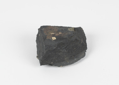
Geological specimen - Slate with Iron pyrites
... In the 1850s the location of Moonambel was part of the ‘Mountain Creek’ pastoral run, but in 1860 reports began to appear of a gold-rush at McKinnon’s ‘Mountain Creek’ station. ...In the 1850s the location of Moonambel was part of the ‘Mountain Creek’ pastoral run, but in 1860 reports began to appear of a gold-rush at McKinnon’s ‘Mountain Creek’ station. ...This specimen was recovered from Moonambel, Donkey Hill, Victoria. Established in the early 1860's, Moonambel is a small town in the Pyrenees region of the Australian state of Victoria. In the 1850s the location of Moonambel was part of the ‘Mountain Creek’ pastoral run, but in 1860 reports began to appear of a gold-rush at McKinnon’s ‘Mountain Creek’ station. By 1861, a township had developed on the diggings site, and on 21 October 1861 the “municipal district of Moonambel, on Mountain Creek” was proclaimed. The name 'Moonambel' is believed to be an aboriginal word meaning 'hollow in the hills'. Slate is a stone with a fine grain that is noted for its persistent strength and ability to naturally split into slabs. It forms under low temperatures and is most often created from clay. Pyrite is a crystallising compound that occurs naturally in grey and blue-black slate that is colloquially referred to as slate-rust as it resembles regular rust. This specimen is part of a larger collection of geological and mineral specimens collected from around Australia (and some parts of the world) and donated to the Burke Museum between 1868-1880. A large percentage of these specimens were collected in Victoria as part of the Geological Survey of Victoria that begun in 1852 (in response to the Gold Rush) to study and map the geology of Victoria. Collecting geological specimens was an important part of mapping and understanding the scientific makeup of the earth. Many of these specimens were sent to research and collecting organisations across Australia, including the Burke Museum, to educate and encourage further study.Pyrite is iron sulphide (also known as “fool's gold”) which is commonly found in slates.Existing label: 53 /moonambel, slate, pyrite, burke museum, beechworth, indigo shire, beechworth museum, geological, geological specimen, mineralogy, victoria -
 Marysville & District Historical Society
Photograph (item) - Black and white photograph, 10-1947
... creek...mountain ash...mountain ash (Eucalyptus regnans) trees within the Cumberland Memorial Scenic Reserve, and relics from former sawmills and gold mining. The Big Culvert is located nearby on the Marysville - Woods Point Road, which was historically part of the Yarra Track. Cambarville was established as a timber mill town in the 1940s. Timber mill owners A Cameron and FJ Barton named Cambarville. They established the mill to salvage timber from trees destroyed in the 1939 bushfires. Cambarville was impacted by the 2009 Black Saturday bushfires and any remaining structures were destroyed. cumberland valley marysville victoria cumberland creek ...An early black and white photograph taken in the Cumberland Valley near Marysville in Victoria.An early black and white photograph taken in the Cumberland Valley near Marysville in Victoria. The Cumberland Valley is near Cambarville which was a timber town near Marysville. Cambarville is notable for its giant mountain ash (Eucalyptus regnans) trees within the Cumberland Memorial Scenic Reserve, and relics from former sawmills and gold mining. The Big Culvert is located nearby on the Marysville - Woods Point Road, which was historically part of the Yarra Track. Cambarville was established as a timber mill town in the 1940s. Timber mill owners A Cameron and FJ Barton named Cambarville. They established the mill to salvage timber from trees destroyed in the 1939 bushfires. Cambarville was impacted by the 2009 Black Saturday bushfires and any remaining structures were destroyed.Among Tall Timber at/ Cumberland Valley. Oct.47. 39cumberland valley, marysville, victoria, cumberland creek, mountain ash, timber mill, mining, a cameron, fj barton, cambarville, big culvert, yarra track, black saturday bushfires, 1939 bushfires, photograph -
 Kiewa Valley Historical Society
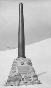
Photo: Memorial on the Staircase Spur Track, Mt Bogong
... The Staircase Spur track to its top starts at Mountain Creek Road going through forest and continuing above the snow line to grass land. ...The Staircase Spur track to its top starts at Mountain Creek Road going through forest and continuing above the snow line to grass land. ...Mt Bogong is the highest mountain in Victoria. The Staircase Spur track to its top starts at Mountain Creek Road going through forest and continuing above the snow line to grass land. The weather can change very quickly with cloud and snow making conditions dangerous. Large sepia photo of the Memorial in snow on the Staircase Spur Track on Mt Bogong. The Memorial has a plaque attached: Sacred to the Memory / of Georgine Gadsden / Edward Neave Welch / John McRae / who perished here during a blizzard / about August 2nd 1943staircase spur memorial, mt bogong -
 Kiewa Valley Historical Society
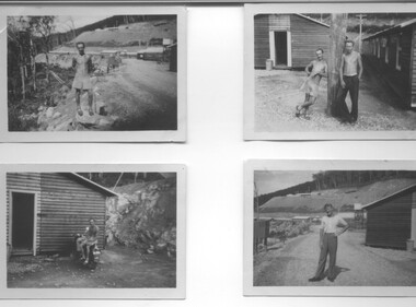
Photograph - 8 Black and white photographs - SECV, Unknown
... Beauty, West Kiewa, Clover Dam and Clover Flat, Howman's sawmill and Howman's Gap, Rocky Valley, Langford's Gap, Pretty Valley, Mountain Creek and Big Hill. These photos have not been identified as to which camp they are taken but typical of the type of accommodation for wages personnel. ...Beauty, West Kiewa, Clover Dam and Clover Flat, Howman's sawmill and Howman's Gap, Rocky Valley, Langford's Gap, Pretty Valley, Mountain Creek and Big Hill. These photos have not been identified as to which camp they are taken but typical of the type of accommodation for wages personnel. ...All eight photographs have been taken at a workmen's camp erected by the State Electricity Commission to house workmen during the construction of the Kiewa Hydro Electric Scheme. These were established in close proximity to various work centres - Junction Camp at Bogong Village, three camps at Mt. Beauty, West Kiewa, Clover Dam and Clover Flat, Howman's sawmill and Howman's Gap, Rocky Valley, Langford's Gap, Pretty Valley, Mountain Creek and Big Hill. These photos have not been identified as to which camp they are taken but typical of the type of accommodation for wages personnel. They followed a general design and layout. There was a mess and recreation hall as well as a building for general trading and postal facilities (this conducted by proprietors of trading stores in Mt. Beauty and Bogong). Originally the rooms accommodated 2 men but later there was a demand for single rooms - the floor size then being 10 feet x 8 feet and furnished with a bed, small table and chair and cupboard with hanging space. The first camps were erected in 1940 and the last was removed in 1962.These photographs are of historical significance as they show the type of accommodation provided for wages personnel working on the Hydro Electric Scheme between 1940 and 1960.Eight small black and white photographs of unknown person and workmen's camp.All photos have been stamped on the back - Two "965U" in red, four "S80 " in green (indistinct) and two "141" in red.workmen's camps, kiewa hydro electric scheme, accommodation, secv, camps on kiewa hydro electric scheme, west kiewa -
 Falls Creek Historical Society
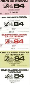
Lift and Ski School Lesson tickets 1984
... Creek Ski School for 1984. The tickets include a full set of adult passes and a set of children’s passes. Other ticket include those for Mountain Staff and Falls Creek Tourist Area Management Committee (F.C.T.A.M.C.) ...Creek Ski School for 1984. The tickets include a full set of adult passes and a set of children’s passes. Other ticket include those for Mountain Staff and Falls Creek Tourist Area Management Committee (F.C.T.A.M.C.) ...SKI TICKETS Before tows and lifts were introduced at Falls Creek, it could take skiers 20 minutes to climb to the Summit … but only TWO minutes to go back to the bottom. The arrival of tows, then chairlifts and T-bars changed the face of skiing forever. The first rope tow was constructed by Toni St. Elmo for the 1951 winter season. Bob Hymans installed a smaller tow for his guests at Skyline Lodge. Tows were still quite slow, so in 1956 Bob Hymans created his single chairlift. In 1958 the Village rope tow, designed by Albury engineer Jock Wilson, opened. It was financed by shareholders including Bill Griffith (Bowna Ski Club) and the Bridgford family (St. Trinian’s Ski Club). Several other tows followed including the Summit T-bar in 1961, built by Ron McCallum and operated by Alpine Developments Pty. Ltd. which was a company formed by C. H. (Bill) Bridgford. By 1982 Falls Creek was served by 16 different lifts or T-bars, all owned and operated by Alpine Developments (Holdings) Pty. Ltd. During the development of Falls Creek, different methods have been used to pay for the use of tows, lifts and T-bars … including metal tokens, single tickets, strips of tickets and season passes. The Falls Creek Historical Society Collection includes many examples of these items.These tickets are significant because they represent a stage in the progression of chair lifts and management at Falls Creek Tourist Village.A collection of tickets issued for entry to Falls Creek, lift passes and lessons at Falls Creek Ski School for 1984. The tickets include a full set of adult passes and a set of children’s passes. Other ticket include those for Mountain Staff and Falls Creek Tourist Area Management Committee (F.C.T.A.M.C.) Volunteers.passes falls creek, chairlift falls creek, falls creek ski school -
 Falls Creek Historical Society
Clothing - Jacket - Falls Creek Volunteer Fire Brigade
... Support for fighting fires at Falls Creek dates back to 1956 when the State Electricity Commission of Victoria (SECV) was building hydroelectric facilities in the area. But this support came from Mount Beauty, 30 kilometres away down the mountain. ...Support for fighting fires at Falls Creek dates back to 1956 when the State Electricity Commission of Victoria (SECV) was building hydroelectric facilities in the area. But this support came from Mount Beauty, 30 kilometres away down the mountain. ...The Falls Creek Volunteer Fire Brigade provided a critical service at Falls Creek. They have since become the Falls Creek CFA with continued support of local Volunteers. The Fire Brigade was formally established in 1995. Support for fighting fires at Falls Creek dates back to 1956 when the State Electricity Commission of Victoria (SECV) was building hydroelectric facilities in the area. But this support came from Mount Beauty, 30 kilometres away down the mountain. Falls Creek locals were concerned by this, so used six available hydrants and a canvas hose to fight any fires on the mountain. In 1964 the SECV gave the village a trailer which could be used with both wheels and skis for summer and winter operations. But this trailer only lasted two years. In the early 1970s, the village was given a 2,000-gallon Ford Blitz 4x4 truck, and additional equipment was quickly acquired by the village including a new locally-constructed trailer with a pumper unit. Falls Creek’s alpine pumper was the first of its kind in Australia, and pumpers used in other ski resorts in Australia are based on this vehicle. In the 1990s, a change in land status meant the Falls Creek area became the responsibility of the Country Fire Authority. This status was formalised in 1995 by a public meeting that formed Falls Creek Fire Brigade. The Falls Creek Brigade volunteers continues providing an essential service for local residents and skiers who visit the mountain each year. This item is significant becaust it represents a community volunteer organisation which has protected the Falls Creek Community for over 20 years.A wool-blend zip fronted jacket with collar and pockets. The body is of black woollen material. The shoulders feature bright yellow reflective material. The logo of Falls Creek Volunteer Fire Brigade is on the upper right chest.Red and white logo featuring fire helmet, axe and hose.falls creek volunteer fire brigade, volunteers falls creek -
 Falls Creek Historical Society
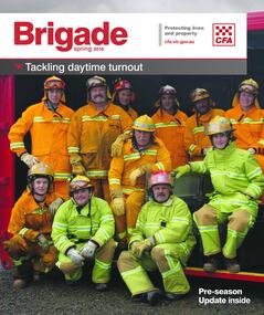
Magazine - Brigade Magazine Spring 2016
... The team that saved the village was considered heroic Support for fighting fires at Falls Creek dates back to 1956 but this support came from Mount Beauty, 30 kilometres down the mountain. ...The team that saved the village was considered heroic Support for fighting fires at Falls Creek dates back to 1956 but this support came from Mount Beauty, 30 kilometres down the mountain. ...Brigade Magazine is issued to members of the Victorian CFA. The Spring edition of 2016 includes an article to acknowledge 21 years of service by the Falls Creek CFA. The article was written by Joy Nowakowski on behalf of the Falls Creek CFA with information provided by the Falls Creek Historical Society. Falls Creek Fire Brigade protects Falls Creek Village from fires throughout the year and supports other brigades to fight bushfires nearby and further away. In 2016 the brigade had 23 year-round volunteers. At a celebratory function at Falls Creek in June 2016, alpine pumper and brigade snowmobiles were on display. Falls Creek’s alpine pumper was the first of its kind in Australia. It had a pumping capacity of 4,000 litres a minute and its tracks enabled it to access areas of the village and ski fields. Until 2016 Falls Creek Village has been threatened by two major fires, the worst being in 2003 when CFA crews saved the village and the adjoining ski field infrastructure right at the boundaries. Snow making equipment was used to create a water/fog barrier that helped stop the fires from taking the village. The team that saved the village was considered heroic Support for fighting fires at Falls Creek dates back to 1956 but this support came from Mount Beauty, 30 kilometres down the mountain. Falls Creek locals were concerned by this, so used six available hydrants and a canvas hose to fight any fires on the mountain. In 1964 the SECV gave the village a trailer which could be used with both wheels and skis for summer and winter operations. But this trailer only lasted two years. In the early 1970s, the village was given a 2,000-gallon Ford Blitz 4WD truck, and additional equipment was quickly acquired by the village including a new locally-constructed trailer with a pumper unit. In the 1990s, a change in land status meant the Falls Creek area became the responsibility of CFA. This status was formalised in 1995 by a public meeting that formed Falls Creek Fire Brigade.This magazine is significant because it contains an article celebrating 21 years of Falls Creek CFA.A publication for CFA members which includes stories about recent incidents, brigades, training, events, community safety, health and safety and general CFA news. falls creek cfa, alpine firefighting, falls creek cfa 21 years -
 Warrnambool and District Historical Society Inc.
Map - Fire Maps, Region 5 Fire Control Map, 1963
... Places covered include Cavendish, Hamilton, Glen Thompson, Dunkeld, Hawkesdale, Warrnambool, Port Fairy and Peterborough and the maps show the type of roads, the swamps and creeks, rivers, railways, mountains and towns....Places covered include Cavendish, Hamilton, Glen Thompson, Dunkeld, Hawkesdale, Warrnambool, Port Fairy and Peterborough and the maps show the type of roads, the swamps and creeks, rivers, railways, mountains and towns. These maps were produced in 1963 so are today of historical interest and they would be useful research tools. ...Two fire maps of south west Victoria.1 This is a rectangular piece of linen folded several times to form a packet with the front part covered with a brown card. The cover has a blue and white label. The map has a white base with red and green markings and red and black printing .2 As .1 abovenon-fictionTwo fire maps of south west Victoriafire maps, warrnambool history -
 Kiewa Valley Historical Society
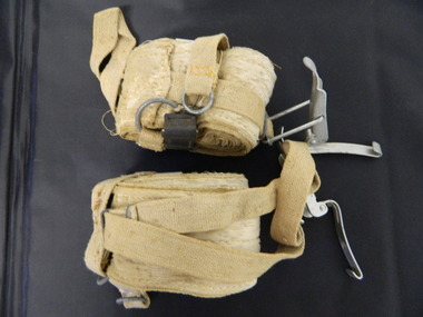
Ski Skins - Pair
... mountains so they could ski down (downhill skiing). Skiers visited the Bogong High Plains especially during the years of the State Electricity Commission of Victoria's construction of the Kiewa Hydro Electric Scheme from the 1930's onwards. Tourists to the area increased during this time and influenced the development of Falls Creek ...Ski skins and webbing were introduced into the Victorian Alps by European skiers. Enthusiasts travelled to enjoy the snow and to explore the Victorian Alps including the Bogong High Plains. This equipment enabled them to travel over snow without slipping when going up hills. They took the skins off when they wanted to slide down hills. In later years waxes were used for cross country skiing and then 'fish tail' markings on the back of skis to enable skiers to travel distances up and down mountains. Later developments also included motor transport (replacing horses to get to the snow line) and roads to take skiers to the ski fields and mechanised tows to take skiers up mountains so they could ski down (downhill skiing).Skiers visited the Bogong High Plains especially during the years of the State Electricity Commission of Victoria's construction of the Kiewa Hydro Electric Scheme from the 1930's onwards. Tourists to the area increased during this time and influenced the development of Falls Creek.Long cream strips with soft short 'fur' on one side and a type of strong hessian on the back with the length of the middle and sides stitched. At one end an adjustable strap is attached to a steel, hinged clasp and at the other end is a loop that fits over the ski. A quarter of the way from each end is a steel attachment for fastening over the ski - the 'toe' end with a rubber embossed flap and the other with a short and long strap each with a steel ring at the end.On the rubber attachment: 'vinersa/pat uno'ski skins; bogong high plains; falls creek -
 Kiewa Valley Historical Society
Photograph - Mt Bogong - Tawonga, 06/05/1937
... mountain through winter but only has snow for the mid winter-spring months. It is around 30 kilometres (19 mi) by road and walking track or 12 kilometres (7.5 mi) direct to Mount Beauty. Falls Creek...mountain through winter but only has snow for the mid winter-spring months. It is around 30 kilometres (19 mi) by road and walking track or 12 kilometres (7.5 mi) direct to Mount Beauty. Falls Creek ...Mount Bogong located in the Alpine National Park and part of the Victorian Alps of the Great Dividing Range, is the highest mountain in Victoria, Australia, at 1,986 metres (6,516 ft) above sea level. The Big River separates the massif of the mountain from the Bogong High Plains to the south. From the nearby town of Mount Beauty to its summit, Mount Bogong rises more than 1,600 metres (5,200 ft), thus making it one of the highest peaks in Australia not only in terms of its elevation above sea level, but also in terms of actual base-to-summit prominence. Mount Bogong is a popular backcountry skiing mountain through winter but only has snow for the mid winter-spring months. It is around 30 kilometres (19 mi) by road and walking track or 12 kilometres (7.5 mi) direct to Mount Beauty. Falls Creek and Mount Hotham ski resorts are also nearby. Camping is relatively safe below the tree line but the summit ridgeline is very exposed. Emergency shelter is also available at Bivouac Hut on the Staircase Spur, and at Cleve Cole, above Camp Creek on the broad ridge to the south of the summit, and Michells Hut on the Eskdale Spur. Mt Bogong is a popular recreational venue in the Kiewa Valley for back country skiing and bush walking and is a favourite with sightseers and popular subject for photographersBlack and white photograph of Mt bogong taken from Tawonga - Thursday May 6th, 1937Handwritten on back of photograph. Thursday May 6th, 1937. Mt Bogong Tawongamt bogong, tawonga, kiewa valley -
 Kiewa Valley Historical Society
Photograph - Building of Myrtleford Ski Club
... Creek and was one of the earliest ski clubs formed and celebrated its 75th anniversary in 2013. In 1949, Myrtleford Ski Club obtained permission for occupancy and began planning the MSC Lodge. There were only three other huts on the mountain...Creek and was one of the earliest ski clubs formed and celebrated its 75th anniversary in 2013. In 1949, Myrtleford Ski Club obtained permission for occupancy and began planning the MSC Lodge. There were only three other huts on the mountain ...Myrtleford Ski Club is a non-commercial, family friendly club. It was one of the earliest lodges to be built at Falls Creek and was one of the earliest ski clubs formed and celebrated its 75th anniversary in 2013. In 1949, Myrtleford Ski Club obtained permission for occupancy and began planning the MSC Lodge. There were only three other huts on the mountain, Bogong Ski Club in an old Army hut, Skyline as the Ski Club of Victoria lodge and the Albury Ski Club lodge. The lodge was built mostly from donated materials. The basement was dug out and lined with stone from the Ruined Castle area, timber was cut (using cross-saws) from the Walpole properties and was milled then carted up to Falls Creek on either the Walpole or Calvert trucks. The iron on the roof was originally a tobacco kiln on Billy McNamara's property. The lodge has undergone many improvements over the years including a second storey added in the 1950’s, updating of accommodation, shower and toilet facilities to meet the changing needs of members. The lodge now caters for 38 people in a variety of shared rooms from two to eight beds per room. Toilet and shower facilities are also shared. The club has a Lodge Managers for the winter season. Myrtleford Ski Lodge was one of the earliest ski lodges built in the Falls Creek area in 1938. It is an excellent example of early sporting and community activities in the Upper Kiewa Valley area. Photograph shows family members, including women, involved in the construction.Sepia photograph of the building of the Myrtleford Ski Club about 1948Handwritten on the back of photograph in black pen - Building Myrtleford Ski Club (about 1948) Stamped on back of photograph - 6 2511myrtleford ski club, skiing, snow sports, victorian alps, falls creek -
 Kiewa Valley Historical Society
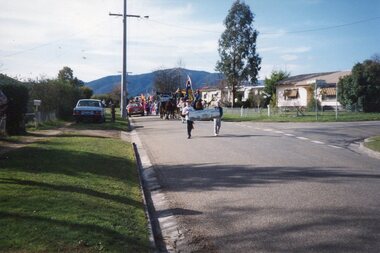
Photographs – Set of 25 colour photographs of the street parade to celebrate the first Official Hoppet race run at Falls Creek in 1991, 1991
... Photos are taken near the corner of Maddison St 1&2 – Horseman & accordion player leading the parade Sign reads ‘Falls Creek The Happy Mountain’ 3-4 Birkbeioner Nordic Ski Club with Chinese Nordic ski representatives 5 & 6- Girl Guides & Brownies 7, 8 & 9- Mt Beauty Primary School & Netball team 10 & 11- UKV Calisthenics Club 12- Lawn Bowls Club 13- Junior Football Club 14- Mt Beauty High School Band (on Wodonga Timber & Hardware truck) 15, 16 17 & 18- Mt Beauty Kindergarten 19,20, 21 & 22- Local Community Vehicles including Community Transport and Fire Brigade 23 & 24- Mt Beauty High School Band 25- Fiat 500 Topolino Vintage Car ...Photos are taken near the corner of Maddison St 1&2 – Horseman & accordion player leading the parade Sign reads ‘Falls Creek The Happy Mountain’ 3-4 Birkbeioner Nordic Ski Club with Chinese Nordic ski representatives 5 & 6- Girl Guides & Brownies 7, 8 & 9- Mt Beauty Primary School & Netball team 10 & 11- UKV Calisthenics Club 12- Lawn Bowls Club 13- Junior Football Club 14- Mt Beauty High School Band (on Wodonga Timber & Hardware truck) 15, 16 17 & 18- Mt Beauty Kindergarten 19,20, 21 & 22- Local Community Vehicles including Community Transport and Fire Brigade 23 & 24- Mt Beauty High School Band 25- Fiat 500 Topolino Vintage Car Photographs – Set of 25 colour photographs of the street parade to celebrate the first Official Hoppet race run at Falls Creek in 1991 ...In 1977 a group of Mount Beauty cross country skiers formed the Birkebeiner Nordic Ski Club. In 1979, a version of the famous Birkebeiner race, the first Australian Birkebeiner was held at Falls Creek. In June 1990 representatives from Australia put their case for a southern hemisphere race in the series. Following a trial event in 1990. Australia became the 12th member of Worldloppet in the winter of 1991, with the first Kangaroo Hoppet. In 1991 a parade and commemorative torch lighting ceremony were organised in Mt Beauty as part of the celebrations to mark the first official Kangaroo Hoppett with participation from local community groups and commercial organisations, the Chamber of Commerce, local government representatives and individuals.Kangaroo Hoppet caters to diverse interests by offering a 42km and 21km event. It also offers a 7km event that attracts skiers, ranging from elite juniors to parents, grandparents, babies and first time skiers. It is recognised on the world cross country ski race calendar. It brings large numbers of participants and spectators to the area which support tourism, local businesses and employment. The 2018 event will be the 28th Kangaroo Hoppet, with cross country skiers travelling from across the country and overseas to compete.PHYSICAL: Set of 22 colour photographs of the street parade to celebrate the first Official Hoppet race run at Falls Creek in 1991. Participants from a range of local community groups are traveling along Kiewa Cres. Photos are taken near the corner of Maddison St 1&2 – Horseman & accordion player leading the parade Sign reads ‘Falls Creek The Happy Mountain’ 3-4 Birkbeioner Nordic Ski Club with Chinese Nordic ski representatives 5 & 6- Girl Guides & Brownies 7, 8 & 9- Mt Beauty Primary School & Netball team 10 & 11- UKV Calisthenics Club 12- Lawn Bowls Club 13- Junior Football Club 14- Mt Beauty High School Band (on Wodonga Timber & Hardware truck) 15, 16 17 & 18- Mt Beauty Kindergarten 19,20, 21 & 22- Local Community Vehicles including Community Transport and Fire Brigade 23 & 24- Mt Beauty High School Band 25- Fiat 500 Topolino Vintage Car No markingskangaroo hoppet; cross country skiing; ski race; bogong high plains, mt beauty, parade -
 Kiewa Valley Historical Society
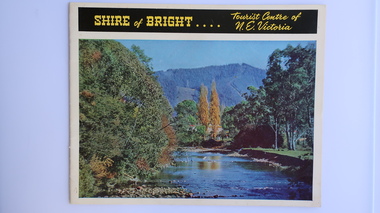
Brochure - Shire of Bright, Shire of Bright Tourist Centre of N.E. Victoria, Pre 1966
... mountain. The back cover is a large colored photo of a man amongst the snow gums in the snow. The towns covered are Bright, Wandiligong, Eurobin, Mt Buffalo, McKay Creek Power Station, The Kiewa Hydro Electric Scheme, Mt Beauty, Kiewa, Bogong including tourist destinations in these areas and their surrounds....mountain. The back cover is a large colored photo of a man amongst the snow gums in the snow. The towns covered are Bright, Wandiligong, Eurobin, Mt Buffalo, McKay Creek Power Station, The Kiewa Hydro Electric Scheme, Mt Beauty, Kiewa, Bogong including tourist destinations in these areas and their surrounds. ...Bright and the surrounding towns were developing a large tourism industry which the Shire of Bright continues to promote, encouraging tourists to visit throughout the year. This high quality brochure has magnificent photos with a map showing the area and the distance (in miles) from the centre - the township of Bright.This brochure is promoting the Shire of Bright encouraging tourism in the area. This is important for the Shire as tourism is the main industry for the Shire. It is interesting to see how tourism has changed (or not) in the area.14 pages on glossy paper including colored and black and white photos. The front cover has the title at the top with yellow print on black background. Below the title is a large colored photo of a river, autumn trees and mountain. The back cover is a large colored photo of a man amongst the snow gums in the snow. The towns covered are Bright, Wandiligong, Eurobin, Mt Buffalo, McKay Creek Power Station, The Kiewa Hydro Electric Scheme, Mt Beauty, Kiewa, Bogong including tourist destinations in these areas and their surrounds.tourism; mt beauty; the kiewa valley; bright shire -
 Kiewa Valley Historical Society
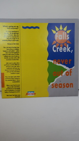
Brochure - Falls Creek Tourism, Falls Creek Never Out of Season
... falls creek ski resort; alpine region in victoria; mountain lodges;...The tourist industry has increased steadily with fishing, cycling and bush walking increasing numbers in the area. falls creek ski resort; alpine region in victoria; mountain lodges; Glossy square brochure folded in in half and half again. ...Falls Creek is a Ski Resort in the north east of Victoria. This brochure has been produced to encourage tourists to visit throughout the year.Tourism to the Kiewa Valley is an important industry for the area. Falls Creek is a ski resort with accommodation during winter for skiers, snow boarders and other snow sports. It involves entertainment, restaurants and associated workers. This brochure is produced to promote the resort throughout the year to increase the occupancy of these lodges. The tourist industry has increased steadily with fishing, cycling and bush walking increasing numbers in the area.Glossy square brochure folded in in half and half again. Front page is yellow on the left with black print on the far left. The right side has the title with blue, green and grey background with yellow, orange and white as part of the title. The back is a man standing in front of a sunset with print in a column towards the right side. Inside includes a map with advertisements for accommodation surrounding it.falls creek ski resort; alpine region in victoria; mountain lodges; -
 Kiewa Valley Historical Society
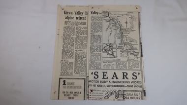
Royalauto Article - Kiewa Valley, Kiewa Valley is Alpine Retreat
... Kiewa Valley Historical Society Mount Beauty Information Centre 31 Bogong High Plains Rd Mt Beauty high-country With the completion of the Kiewa Hydro Electric Scheme in 1961 tourism became important to the Kiewa Valley Tourism was encouraged in the Kiewa Valley with Falls Creek, a ski resort on the Bogong High Plains and the SECV's Kiewa Hydro Electric Scheme completed also in the mountains and in the townships of Bogong and Mt Beauty. falls creek mt beauty bogong tourism racv kiewa valley "Royalauto march 1966" Two yellowed pates cut out of the Royalauto magazine dated march 1966 Kiewa Valley is Alpine Retreat Royalauto Article - Kiewa Valley ...With the completion of the Kiewa Hydro Electric Scheme in 1961 tourism became important to the Kiewa ValleyTourism was encouraged in the Kiewa Valley with Falls Creek, a ski resort on the Bogong High Plains and the SECV's Kiewa Hydro Electric Scheme completed also in the mountains and in the townships of Bogong and Mt Beauty.Two yellowed pates cut out of the Royalauto magazine dated march 1966"Royalauto march 1966"falls creek, mt beauty, bogong, tourism, racv, kiewa valley -
 Kiewa Valley Historical Society
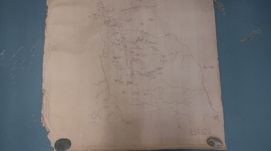
Map - Bogong High Plains
... Kiewa Valley Historical Society Mount Beauty Information Centre 31 Bogong High Plains Rd Mt Beauty high-country Bogong high Plains showing mountains, places, roads and rivers Historical changes of infrastructure on the Bogong High Plains bogong high plains map Bogong High Plains, hand written and 'copied with considerable simplification from F.C.V. (Falls Creek ...Bogong high Plains showing mountains, places, roads and riversHistorical changes of infrastructure on the Bogong High PlainsBogong High Plains, hand written and 'copied with considerable simplification from F.C.V. (Falls Creek V.?) 'Feathetop' L 'Tawonga'. Paper is yellowed, writing is brown.bogong high plains map -
 Kiewa Valley Historical Society
Seal Skins Ski Straps / Soles
... mountains so they could ski down (downhill skiing). Skate skiing has also developed as another form of skiing. Skiers visited the Bogong High Plains during summer and winter to explore and enjoy the High Plains. The equipment used was a forerunner to the variety used today and the different types of skiing done today. Falls Creek ...Seal skin straps and webbing were introduced into the Victorian Alps by European skiers. Enthusiasts travelled to enjoy the snow and to explore the Victorian Alps including the Bogong High Plains. This equipment enabled them to travel over snow without slipping when going up hills. They took the skins off when they wanted to slide down hills. In later years, waxes were used for cross country skiing and then 'fish tail' markings on the back of skis to enable skiers to travel distances up and down mountains. Later developments also included motor transport (replacing horses to get to the snow line) and roads to take skiers to the ski fields and mechanised tows to take skiers up mountains so they could ski down (downhill skiing). Skate skiing has also developed as another form of skiing.Skiers visited the Bogong High Plains during summer and winter to explore and enjoy the High Plains. The equipment used was a forerunner to the variety used today and the different types of skiing done today. Falls Creek was developed during the construction of the Kiewa Electric Hydro Scheme and was influenced by the number of Europeans working on the scheme and their desire to make use of the snow during winter.Each Seal skin has: Seal skin sewn onto one side of a strap of webbing. There is a webbing loop on the front that slips over a small point at the front of the ski. There is a webbing strap attached to the back of the seal skin sole coming over the back of the ski that clips metal fasteners onto a loop of webbing behind the boot.skiing. snow. high plains. seal skins. cross country skiing. alpine sports. -
 Kiewa Valley Historical Society
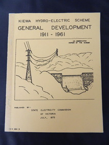
Book - Kiewa Hydro Electric Scheme 1911-1961, Kiewa Hydro-Electric Scheme /General Development / 1911-1961, July, 1973
... creek power station. west kiewa power station. clover power station. secv. rocky valley dam. flora. fauna. geology. On the newspaper cutting hand written "Burnett 1959 Later than May." Yellow cardboard book with front cover of black writing and sketch of power lines and spillway in the mountains. 2 staples are covered along the spine with tape. ...The book is an abbreviated history of the Kiewa Hydro Electric Scheme.This book summarises the stages of the Kiewa Hydro Electric Scheme from its conception in 1911 through to 1961. The newspaper cutting gives additional information about Rocky Valley Dam.Yellow cardboard book with front cover of black writing and sketch of power lines and spillway in the mountains. 2 staples are covered along the spine with tape. There are 22 pages. 2 copies Inside one copy there is a newspaper cutting entitled "Main Dam in Kiewa Scheme Finished" and later published pages of 1. Floras of Bogong 2. Geology of Kiewa Area 3. Fauna and 4. 'Brief history of the Kiewa Scheme. An abbreviated History of the SchemeOn the newspaper cutting hand written "Burnett 1959 Later than May."kiewa hydro electric scheme. mt beauty. dederang. bogong. mckay creek power station. west kiewa power station. clover power station. secv. rocky valley dam. flora. fauna. geology. -
 Kiewa Valley Historical Society
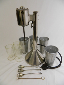
Milkshake Maker Set, 1940 - 1950's
... The Milk Shaker machine was then lent to the Tawonga cafe which was situated opposite the Tawonga Hotel on the Kiewa Valley Highway near Mountain Creek Road. When the cafe owner bought their own milk shaker machine the original was returned to Vera who lived at the Tawonga Post Office. ...The milk shaker machine was used in milk bars during the 1940's and 1950's often using fresh milk from the local diaries. Modern machines are more compact with a variety of different settings and the ability to blend a variety of food including fruit and vegetables as well as liquids.Vera Drummond worked in the Tawonga Milk Bar where she used the Milk Shaker machine. The premises were leased out until it finally closed. The Milk Shaker machine was then lent to the Tawonga cafe which was situated opposite the Tawonga Hotel on the Kiewa Valley Highway near Mountain Creek Road. When the cafe owner bought their own milk shaker machine the original was returned to Vera who lived at the Tawonga Post Office. The milk shakes were made with fresh real milk direct from the diary and enjoyed by Vera's grandchildren and great grandchildren especially on summer holidays.This set consists of: 1 stainless steel milkshake blender with black electric cord attached; 3 moulded glasses with vertical grooves; 4 aluminium mixing beakers also with vertical grooves; 3 long handle stainless steel mixing spoons; 1 stainless steel swivel stick. The blender is heavy with an enclosed cylinder at the top containing the motor with a rotating mixer hanging below it. This is supported by a long vertical enclosed cylinder attached to a base where the electric cord is placed. This cylinder has parts attached to hold the beakers during mixing.On the cylinder with the motor - "Type D3; No. 1675; Volt 230; Watt 40; RPM A; ACDC; (the letter) R (with) G (in the top) (and) E (between the 'feet') Reg. Des.No. 24264/65 Spoons: 2 rows of embossed writing on handle end but illegiblemilkshake maker machine; vera drummond; tawonga milk bar; tawonga post office -
 Kiewa Valley Historical Society
Plans - Kiewa Works Area and Environs
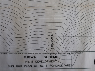
... Creek Area, Construction Layout 4. Kiewa Works and Environs 5. North Eastern Victoria and Adjoining Snowy Mountains Region...Creek Area, Construction Layout 4. Kiewa Works and Environs 5. North Eastern Victoria and Adjoining Snowy Mountains Region Plans - Kiewa Works Area and Environs ...State Electricity Commission of Victoria constructed the Kiewa Hydro Electric Scheme from the late 1940s to 1961. These plans were used during the construction.Plans and Maps were used during the construction of the Kiewa Hydro Electric SchemeTransparent with blue tinge plans/maps created by the SECV during the construction of the Kiewa Hydro Electric Scheme. 1. Kiewa Scheme No 5 Development Contour Plan of No 5 Pondage Area 2. Mt Beauty Township 3. Kiewa Scheme No 1 Development - McKay Creek Area, Construction Layout 4. Kiewa Works and Environs 5. North Eastern Victoria and Adjoining Snowy Mountains Regionsecv, kiewa hydro electric scheme plans -
 Kiewa Valley Historical Society
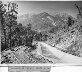
Photo - Bogong Creek Race Line
... Creek Race Line in pen and attafhed to the photo. On the back "Property of / State Electricity Commission of Victoria/ Publicity photo / Permission to Publish must be obtained / and acknowledgement made. / Negative No. 14-138 Shiny black and white photo showing the railway track, with a locomotive on it, beside the race line. Snow is on the surrounding mountains ...The SECV constructed the Kiewa Hydro Electric Scheme which included race lines to catch the water and feed it into the dams that they built to create hydro electric power. The rail line was used to construct the race line and enables the race line to be easily checked for maintenance eg. fallen trees The SECV constructed the Kiewa Hydro Electric Scheme from the late 1940s to 1961 being one of the first hydro schemes and hence environmently friendly.Shiny black and white photo showing the railway track, with a locomotive on it, beside the race line. Snow is on the surrounding mountains. ;Bogong Creek Race Line in pen and attafhed to the photo. On the back "Property of / State Electricity Commission of Victoria/ Publicity photo / Permission to Publish must be obtained / and acknowledgement made. / Negative No. 14-138bogong creek race line, kiewa hydro electric scheme -
 Kiewa Valley Historical Society
A) Document - The Field Welding of No. 1 Pipeline - Kiewa. B) Book - SECV, Kiewa Hydro Electric Works, Foreman's Guide, A) by J. M. Scott, Welding Inspector B) by State Electricity Commission of Victoria
... No. 1 Pipeline heads down the mountain from McKay Power Station (the Kiewa Hydro Electric Scheme) and can be seen from the Falls Creek Rd.. ...Kiewa Valley Historical Society Mount Beauty Information Centre 31 Bogong High Plains Rd Mt Beauty high-country No. 1 Pipeline heads down the mountain from McKay Power Station (the Kiewa Hydro Electric Scheme) and can be seen from the Falls Creek Rd.. ...No. 1 Pipeline heads down the mountain from McKay Power Station (the Kiewa Hydro Electric Scheme) and can be seen from the Falls Creek Rd.. The pipeline is 1635m long. It was built on the mountain rather than as a tunnel inside the mountain - "It was argued that a pressure pipeline on the surface, while not actually cheaper than the tunnel could possibly save one year in construction time.'The document is a report on the welding involved on the No. 1 pipeline. J. M. Scott was the welding inspector for the SECV on the Kiewa Hydro Electric Scheme. The book is produced by the SECV and is the 'Foremen's Guide' and includes rules and regulations across all areas.A) 10 pages of a 'field record' all pages typed on one side. Stapled on top left corner B) Small, fat book c190 pages plus appendix. Thick and 'tattered looking'. Bound by flexible 'cloth?'(linen?) and fastened with 2 rusty fasteners.B) Cover - F/M J. Scott and red SEC stamp. Inside cover: "checked ... 22-8-55" and "checked 18-11-55"j.m. scott welding inspector, no 1 pipeline mckay power station, kiewa hydro electric scheme -
 Kiewa Valley Historical Society
Book - Alpine Resorts - 2020 draft strategy, Alpine Resorts 2020 draft strategy
... This report was prepared to guide the sustainable long-term planning and management of Victoria's six Alpine Resorts. Falls Creek, Lake Mountain, Mount Baw Baw, Mount Buller, Mount Hotham and Mount Stirling, after the catastrophic bush fires of 2002- 2003. ...This is a commissioned report auspiced by the State Government of Victoria - Department of Sustainability and Environment 2003.This report was prepared to guide the sustainable long-term planning and management of Victoria's six Alpine Resorts. Falls Creek, Lake Mountain, Mount Baw Baw, Mount Buller, Mount Hotham and Mount Stirling, after the catastrophic bush fires of 2002- 2003.Colorured cardboard front cover with two people on air mattresses in foreground. Title white on bue top left corner. 40 glossy thick paper/card pages. A4Logo "Victoria / The Place to betourism in alpine resorts, sustainability and environment, victorian government, 2002-2003 bushfires