Showing 1748 items matching "north-east district"
-
 Ambulance Victoria Museum
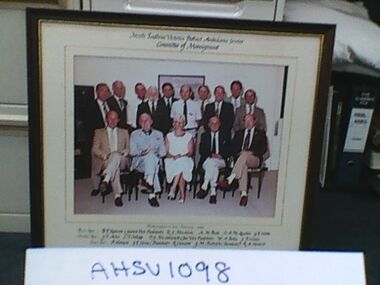
Photograph, framed, North East Victoria District Ambulance Service, Committee of Management, 19 February 1985
... Photograph, framed, North East Victoria District Ambulance Service, Committee of Management...North East Victoria District Ambulance Service, Committee of Management. ...Ambulance Victoria Museum 1/55 Barry Street Bayswater melbourne North East Victoria District Ambulance Service, Committee of Management. ...North East Victoria District Ambulance Service, Committee of Management. All board members named on photograph.Colour photograph with cream matting in brown frame. One woman and 14 men in two rows - one row of five sitting.PHOTOGRAPHED ON 19 FEBRUARY 1985 -
 Marysville & District Historical Society
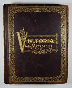
Book - Hardcover book, McCarron, Bird & Co, Victoria and its Metropolis-Past and Present-Volume 2, 1888
... ...north-east district...A history of the various colonies and districts of Victoria from the time of the discovery of Australia through until 1888. melbourne victoria pioneers colonisation history fauna flora banking finance medicine western district south-western district wimmera district geelong district ballarat district avoca district coliban district campase district loddon district lower goulburn district upper goulburn district ovens district north-east district gippsland district mornington district westernport district upper yarra district evelyn district bourke district A history of the various colonies and districts of Victoria from the time of the discovery of Australia through until 1888. ...A history of the various colonies and districts of Victoria from the time of the discovery of Australia through until 1888.Hardback. Dark brown cover with the title in gold lettering. There is also a border in gold decorating the outer edge of the front cover. The spine is also decorated in gold along with the title and the volume number.non-fictionA history of the various colonies and districts of Victoria from the time of the discovery of Australia through until 1888.melbourne, victoria, pioneers, colonisation, history, fauna, flora, banking, finance, medicine, western district, south-western district, wimmera district, geelong district, ballarat district, avoca district, coliban district, campase district, loddon district, lower goulburn district, upper goulburn district, ovens district, north-east district, gippsland district, mornington district, westernport district, upper yarra district, evelyn district, bourke district -
 Wangaratta High School
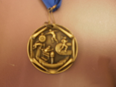
WHS Sports Medals, 2005-2006
... Three golden medals with a blue ribbon presented by the North East District Secondary School Sporting Association. ...Wangaratta High School 17-49 Edwards Street Wangaratta high-country Three golden medals with a blue ribbon presented by the North East District Secondary School Sporting Association. ...Three golden medals with a blue ribbon presented by the North East District Secondary School Sporting Association. On one face the medals depict four figures doing athletics, and on the other the medals read NEDSSSA U17 athletics champion 2005 NEDSSSA U21 athletics champion 2005 NEDSSSA U16 athletics champion 2006 -
 Warrnambool and District Historical Society Inc.
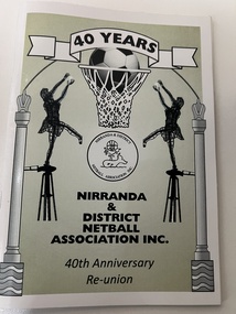
Booklet, Nirranda & District Netball Ass 1840-1970, 2011
... District Netball Association Inc. It is a 40th anniversary publication. This association was formed in 1971 with Nirranda, Nirranda South, AllansForest, Curdievale and Commingle the competing teams. In 1991 the competing teams were AllansForest, Nullawarre North, Nirranda and Nirranda South and these clubs continued until 2010 when a new format saw individual teams playing under the administration of the Association. The Association continues today. This book is of interest as a record of the Nirranda & District Netball Association. Nirranda is a small settlement 28 kilometres south east ...This is a booklet giving information on the Nirranda & District Netball Association Inc. It is a 40th anniversary publication. This association was formed in 1971 with Nirranda, Nirranda South, AllansForest, Curdievale and Commingle the competing teams. In 1991 the competing teams were AllansForest, Nullawarre North, Nirranda and Nirranda South and these clubs continued until 2010 when a new format saw individual teams playing under the administration of the Association. The Association continues today.This book is of interest as a record of the Nirranda & District Netball Association. Nirranda is a small settlement 28 kilometres south east of Warrnambool and its history and activities are of interest to the surrounding districts. Netball is the most popular sport for women in the area and the clubs are mostly allied with the local football teams. This is a soft cover booklet of 52 pages. The cover has a white background with a stylized sketch of two netballers (wire sculptures) standing on a windmill frame and throwing at a netball ring with decorative columns on the side. The sketch is in black, green and grey tonings. The booklet contains a Foreword, Personal Profiles, Extracts from Association Minutes and records of competition winners. The pages are stapled.Front Cover: ‘40 Years Nirranda & District Netball Association Inc, 40th Anniversary Re-union’. nirranda & district netball association, history of nirranda, warrnambool history -
 Warrnambool and District Historical Society Inc.
Document, Collett and Bain, Notice of meeting Warrnambool Shire, 1963
... district in 1855. Portion of the shire was again annexed to the city in 1955. The Warrnambool shire covers the area on north east and western sides of the city of Warrnambool covering approximately 600 square miles and has a rich history of farming and dairy products. ...district in 1855. Portion of the shire was again annexed to the city in 1955. The Warrnambool shire covers the area on north east and western sides of the city of Warrnambool covering approximately 600 square miles and has a rich history of farming and dairy products. ...This booklet commemorates the 100th anniversary of the proclamation of the Shire of Warrnambool. The original proclamation was read from the Government gazette 13/12/1863 Pg 2958. This follows from being proclaimed a roads district in 1854 which was then partly portioned and proclaimed the Municipal district in 1855. Portion of the shire was again annexed to the city in 1955. The Warrnambool shire covers the area on north east and western sides of the city of Warrnambool covering approximately 600 square miles and has a rich history of farming and dairy products. A program which commemorates 100 years of the shire of Warrnambool. It contains a comprehensive list of councillors who served during that time.White light card cover with royal blue text and tied with royal blue ribbon.Pale blue vertical lines. Shire crest with dates either side at top centre of page.Back cover has list of councillors names who have served from 1863 up to 1963. Photographs in green tinge inside front and back covers. 8 pages. Cr Cyril Geoffery Boyle. Thursday 12th December 1963.Mr Robert Burke, Cr C S Brown, Cr C G Boyle, A F Ponting,The Honourable Murray Porter, Hon R W Mack, Cr J Pascoe, Mr J W Crawley, Mr L Crawley, J Wm Crawley, Jnr, R L Crawleywarrnambool,, warrnambool shire, cr c g boyle, warrnambool shire 1863, warrnambool shire 1963 -
 Warrnambool and District Historical Society Inc.
Document - Warrnambool City Council Preliminary Report Industrial Estate West Warrnambool, E Johnson, 9 March 1973
... Warrnambool and District Historical Society Inc. 2 Gilles Street (south of Merri St) Warrnambool great-ocean-road This preliminary report relates to 32½ acres of council owned land in West Warrnambool bounded on the North by McMeekin Road, on the East by Scott Street, on the South by Evans Street and on the West by the rear boundaries of properties facing Landmann and Granter Streets. ...This preliminary report relates to 32½ acres of council owned land in West Warrnambool bounded on the North by McMeekin Road, on the East by Scott Street, on the South by Evans Street and on the West by the rear boundaries of properties facing Landmann and Granter Streets. In 2010, West Warrnambool was the largest of Warrnambool’s existing industrial areas, comprising approximately 109ha of industrial zoned land, the majority of which (101ha) is zoned IN1Z, with the remainder zoned INZ3. The area comprises a mixture of lot sizes supporting a diverse mix of industries. Larger parcels are occupied by the abattoirs, scrap metal industries, freight, the Council Depot and storage. Smaller lots are occupied by smaller manufacturers and wholesalers and service industries. [Ref: Warrnambool Industrial Land Use Review. Mesh Pty Ltd July 2010]This document is a preliminary report prepared by the Warrnambool City Council Engineer in March 1973 and provides an example of the planning process undertaken to develop one of Warrnambool's industrial areas. It contains details and costings of the proposed subdivision. Two foolscaps size pages of typewritten information. A detailed topographical map of the area with areas highlighted in blue, red, green, blue and purple pen.warrnambool city council, west warrnambool, industrial estate -
 Warrnambool and District Historical Society Inc.
Card, Poems The Future The Rambler, 1942
... Warrnambool and District Historical Society Inc. 2 Gilles Street (south of Merri St) Warrnambool great-ocean-road These two items were sent in the 1940s to Tom Terrington of Framlingham (about 28 kilometres north east of Warrnambool) from Donald Mackintosh. ...These two items were sent in the 1940s to Tom Terrington of Framlingham (about 28 kilometres north east of Warrnambool) from Donald Mackintosh. Tom Terrington (b.1897) worked at various jobs until he took over the Framlingham store in the 1940s. He was a scholarly person with a wide knowledge of English literature. He wrote poetry and researched and wrote extensively on Framlingham history. Donald Mackintosh (1866-1951) was Australia’s first Olympic shooting gold medallist. He competed in trapshooting events all over the world, winning 30 gold medals, making a considerable amount of money and holding the world trapshooting championship title from 1903 to 1908. He was a keen photographer and wrote poetry under the name of ‘The Rambler’. This small folder is of great interest as it contains a poem sent to Tom Terrington by Donald Mackintosh (The Rambler). Tom Terrington is important in Framlingham’s history and his friendship with Donald Mackintosh, an Australian and world trapshooting champion and a poet is of considerable interest. The tone of the poem echoes also the despondency felt by Australians during the darkest days of World War Two. This is a piece of cream thickened paper folded in two with a typed copy of a poem pasted on the inside of the paper and a copy of a prose piece typed in ornate script and pasted on to a piece of cardboard and enclosed in the cream folder. Both of the typed items have handwritten messages at the bottom of the text. The cream folder is a little crumpled and stained. ‘The Rambler 1942-3’ ‘For T. Terrington from Dld Mackintosh with best wishes 1942-3’tom terrington, donald mackintosh -
 Warrnambool and District Historical Society Inc.
Map - Maps, Soldiers Settlement WW2, Circa 1950
... The maps are as follows: .1 Narrapumelap Estate ( Ripon & Hampden) .2 Narrapumelap Estate Part 2 (Villers & Ripon) .3 Narrapumelap Estate Part 3 ( Villiers & Ripon) .4 Burrumbeet Estate ( Ripon) .5 ' Berrambool' Estate 9 Hampden & Villiers) .6 ' Hopkins Hill' Estate Villiers 4011 acres .7 Caramut North No 2 Estate ( Villiers ) .8 ' Morpor' Estate ( Villiers) 4172 acres .9 ' Morgiana' Estate ( Normandy) 3453 acres .10 ' Chatsworth House' ( Villiers) 9341 Acres .11 ' East Elwood' Estate Villiers 2407 acres .12 Grey's Estate ( Mornington) 1151acres .13 ' Rowes Estate' ( Buln Buln Gippsland 733 acres .14 'Tarrone' Estate No 2 Part map .15 'Chaldon Meade' Estate (Bourke) Bulla 517 acres .16 ' Terranallum South' Estate Hampden 3757 acres .17 ' Brung Brungle' Estate Dundas 695 .18 ' Armidale ' Estate ( Dundas)2108 acres .19 ' Moyne Falls' Estate ( Villiers) 627 acres .20' Yulong' Estate 9 Lowan 6321 acres .21 Murray Valley Irrigation District 9 Moira)113 acres .22 Murray Valley Irrigation District 103 acres .23 ' Mount Fyans' Estate ( Hampden) .24 ' Barwidgee ' Estate ( Villiers) 4277 acres .25 'Pine Hills' Estate 2nd portion ( Lowan) 6190 acres ...As such they have historic and social interest and significance. narrapumelap berrambool hopkins hill caramut north morpor chatsworth house east elwood terrinallum moyne falls tarrone caramut soldiers settlers Burrumbeet morgiana grey's estate mornington chaldon meade brung brungle The maps are as follows: .1 Narrapumelap Estate ( Ripon & Hampden) .2 Narrapumelap Estate Part 2 (Villers & Ripon) .3 Narrapumelap Estate Part 3 ( Villiers & Ripon) .4 Burrumbeet Estate ( Ripon) .5 ' Berrambool' Estate 9 Hampden & Villiers) .6 ' Hopkins Hill' Estate Villiers 4011 acres .7 Caramut North No 2 Estate ( Villiers ) .8 ' Morpor' Estate ( Villiers) 4172 acres .9 ' Morgiana' Estate ( Normandy) 3453 acres .10 ' Chatsworth House' ( Villiers) 9341 Acres .11 ' East Elwood' Estate Villiers 2407 acres .12 Grey's Estate ( Mornington) 1151acres .13 ' Rowes Estate' ( Buln Buln Gippsland 733 acres .14 'Tarrone' Estate No 2 Part map .15 'Chaldon Meade' Estate (Bourke) Bulla 517 acres .16 ' Terranallum South' Estate Hampden 3757 acres .17 ' Brung Brungle' Estate Dundas 695 .18 ' Armidale ' Estate ( Dundas)2108 acres .19 ' Moyne Falls' Estate ( Villiers) 627 acres .20' Yulong' Estate 9 Lowan 6321 acres .21 Murray Valley Irrigation District 9 Moira)113 acres .22 Murray Valley Irrigation District 103 acres .23 ' Mount Fyans' Estate ( Hampden) .24 ' Barwidgee ' Estate ( Villiers) 4277 acres .25 'Pine Hills' Estate 2nd portion ( Lowan) 6190 acres A collection of 25 paper maps which relate to to the soldiers settlement post World War 2. ...The soldiers' settlement scheme operated after the first and second world wars in an effort to more closely settle the land and also give opportunities to returned soldiers. Crown land and other larger estates were acquired for the purpose. Most of these maps relate to the area north of Warrnambool where many of the subdivisions were parts of larger estates.These maps pertaining to the Soldiers' Settlement program, relate to an interesting part of Australian and local history. As such they have historic and social interest and significance.A collection of 25 paper maps which relate to to the soldiers settlement post World War 2. Some have details of the people allocated the land and some smaller maps have the printed details of the applicants requirements.Text is black on white paper which in some cases is quite aged. The maps are as follows: .1 Narrapumelap Estate ( Ripon & Hampden) .2 Narrapumelap Estate Part 2 (Villers & Ripon) .3 Narrapumelap Estate Part 3 ( Villiers & Ripon) .4 Burrumbeet Estate ( Ripon) .5 ' Berrambool' Estate 9 Hampden & Villiers) .6 ' Hopkins Hill' Estate Villiers 4011 acres .7 Caramut North No 2 Estate ( Villiers ) .8 ' Morpor' Estate ( Villiers) 4172 acres .9 ' Morgiana' Estate ( Normandy) 3453 acres .10 ' Chatsworth House' ( Villiers) 9341 Acres .11 ' East Elwood' Estate Villiers 2407 acres .12 Grey's Estate ( Mornington) 1151acres .13 ' Rowes Estate' ( Buln Buln Gippsland 733 acres .14 'Tarrone' Estate No 2 Part map .15 'Chaldon Meade' Estate (Bourke) Bulla 517 acres .16 ' Terranallum South' Estate Hampden 3757 acres .17 ' Brung Brungle' Estate Dundas 695 .18 ' Armidale ' Estate ( Dundas)2108 acres .19 ' Moyne Falls' Estate ( Villiers) 627 acres .20' Yulong' Estate 9 Lowan 6321 acres .21 Murray Valley Irrigation District 9 Moira)113 acres .22 Murray Valley Irrigation District 103 acres .23 ' Mount Fyans' Estate ( Hampden) .24 ' Barwidgee ' Estate ( Villiers) 4277 acres .25 'Pine Hills' Estate 2nd portion ( Lowan) 6190 acres narrapumelap, berrambool, hopkins hill, caramut north, morpor, chatsworth house, east elwood, terrinallum, moyne falls, tarrone, caramut soldiers settlers, burrumbeet, morgiana, grey's estate mornington, chaldon meade, brung brungle -
 Warrnambool and District Historical Society Inc.
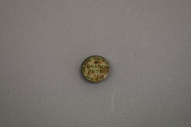
Badge, Panmure Hall Improvement
... Warrnambool and District Historical Society Inc. 2 Gilles Street (south of Merri St) Warrnambool great-ocean-road This badge was sold at a local fete to raise funds for improvements to the Panmure Hall. Panmure is a small town on the Princes Highway 22 kilometres north east ...This badge was sold at a local fete to raise funds for improvements to the Panmure Hall. Panmure is a small town on the Princes Highway 22 kilometres north east of Warrnambool. In 1933 the population of Panmure was 273. The Panmure Hall still serves the community.This badge is of interest as an example of a local community effort to raise funds for local communities.Circular badge with cream background surrounded by a green rim. The text and a fan shaped medallion are also green. A black number is also featured. There is a clip pin on the reverse.PANMURE HALL IMPROVEMENT APPEAL FEB. 15-16. 1933 GRAND FETE 59 -
 Warrnambool and District Historical Society Inc.
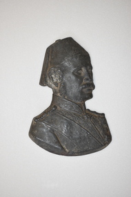
Plaque - Metal Plaque (man’s head)
... District Historical Society Inc. 2 Gilles Street (south of Merri St) Warrnambool great-ocean-road This metal plaque was dug up in a Warrnambool garden in the early 1980s. It appears to be an item that would have been attached to a wall or building and is possibly a representation of a British military figure involved in military campaigns or colonial administration in a British Empire outpost in the 19th century or early 20th century, perhaps in the Middle East or in north Africa. ...This metal plaque was dug up in a Warrnambool garden in the early 1980s. It appears to be an item that would have been attached to a wall or building and is possibly a representation of a British military figure involved in military campaigns or colonial administration in a British Empire outpost in the 19th century or early 20th century, perhaps in the Middle East or in north Africa. It could also be a non-British military figure from the same areas. This item is of minor interest as an object found in Warrnambool but with no known details of what it represents. . It is retained pending further research. This is a metal plaque showing the head and shoulders of a man wearing a fez and a military uniform. The back is slightly hollowed out.warrnambool, metal plaque, military plaque -
 Warrnambool and District Historical Society Inc.
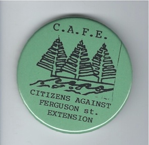
Badge, Citizens against Ferguson St Extension
... Warrnambool and District Historical Society Inc. 2 Gilles Street (south of Merri St) Warrnambool great-ocean-road This badge was issued to supporters of the 1980s campaign called ‘Citizens Against Ferguson Street Extension’. Ferguson Street is in East Warrnambool and at the time the road was formed but there were no houses on the north ...This badge was issued to supporters of the 1980s campaign called ‘Citizens Against Ferguson Street Extension’. Ferguson Street is in East Warrnambool and at the time the road was formed but there were no houses on the north side. The proposal was to extend the street at the north east end so that access could be made to east Warrnambool and Deakin University. The local residents opposed the proposal because it would increase traffic in the quiet suburban areas. The scheme did not go ahead. This badge is of minor interest as an example of a local campaign against an unpopular City Council proposal. This is a green circular-shaped badge made of plastic. It has black printing with a sketch of three Norfolk Island pine trees on the front and a metal clip at the back for attachment to a person’s clothing. The back has an image of a map of Australia.‘C.A.F.E. Citizens Against Ferguson St. Extension’ ferguson street, history of warrnambool -
 Warrnambool and District Historical Society Inc.
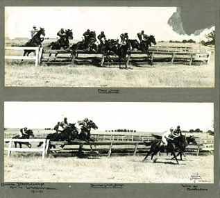
Photograph - Booval Steeplechase jumps 1921, C 1922
... Warrnambool and District Historical Society Inc. 2 Gilles Street (south of Merri St) Warrnambool great-ocean-road Booval Hill was an early name for the area to the north east of the Princes Highway and Liebig St intersection. ...Booval Hill was an early name for the area to the north east of the Princes Highway and Liebig St intersection. The winning horse being a horse named Bloodstain which is recorded on the mount of the photograph. This item has a social and historical significance. Socially, it shows an early association which Warrnambool has had with steeple-chasing, with jumps racing still representing an important part of the horseracing calendar. The photo has a strong link with Warrnambool, being one of many photographs taken by The Jordan studios which operated out of premises in Liebig Street .Two black and white photos mounted on card showing the first and second last jumps of the Booval Steeplechase in 1921. There is text handwritten below the photographs and there is damage to the top right hand corner of the top photograph.Bottom photo signed Arthur Jordan 6 W'bool.steeplechase, warrnambool, booval, bloodstain, booval hill1921, jordan studios, horse racing -
 Warrnambool and District Historical Society Inc.
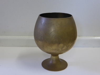
Goblet, Brass Goblet, Mid 20th century
... Warrnambool and District Historical Society Inc. 2 Gilles Street (south of Merri St) Warrnambool great-ocean-road This brass goblet has been used by the now-defunct Apex Cub of Warrnambool as a jar to hold the fines money contributed by members at a meeting. It may have been made in India, North Africa or a Middle East ...This brass goblet has been used by the now-defunct Apex Cub of Warrnambool as a jar to hold the fines money contributed by members at a meeting. It may have been made in India, North Africa or a Middle East country but nothing is known of its origin or provenance.This goblet’s history is sketchy and it may be of use now in displays. The Warrnambool and District Historical Society has other historical material associated with the disbanded Warrnambool Apex Club.This is a brass goblet (a bowl on a pedestal base). It is etched with ornamental patterns and floral shapes. Handwritten on base of object: ‘W’bool Apex Club Fines Jar’. apex club of warrnambool, warrnambool -
 Warrnambool and District Historical Society Inc.
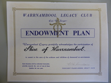
Certificate - Warrnambool Legacy Club to Shire of Warrnambool
... Warrnambool and District Historical Society Inc. 2 Gilles Street (south of Merri St) Warrnambool great-ocean-road Warrnambool Legacy Club was founded in 1947; prior to that it was part of Geelong Legacy Club. It covers an area in South West Victoria bounded by Port Fairy in the west, Mortlake, Derrinallum and Lismore to the north, and Camperdown, Timboon and Port Campbell in the south and east. ...Warrnambool Legacy Club was founded in 1947; prior to that it was part of Geelong Legacy Club. It covers an area in South West Victoria bounded by Port Fairy in the west, Mortlake, Derrinallum and Lismore to the north, and Camperdown, Timboon and Port Campbell in the south and east. The Warrnambool Legacy Club has contributed to the welfare of widows and children of past soldiers. In turn it has relied upon the generosity of local organisations and people to maintain their work. The Shire of Warrnambool would have been one of many of these groups who contributed in a generous way.Cream card with gold border. Dark blue printing with Warrnambool Legacy club at the top. Legacy logo printed in gold underneath.Signed by W.G. Sinclair. warrnambool, shire of warrnambool, warrnambool legacy club, legacy club endowment plan, w g sinclair -
 Kiewa Valley Historical Society
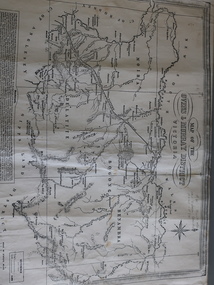
Map of the Ovens and Murray District of Victoria
... north-east and in particular, Beechworth where residents of the Kiewa Valley may have shopped or visited for appointments. Beechworth Black and white map with references to roads and gold. The centre of the map is Beechworth and in the bottom left side of the map is the heading Beechworth with 12 lines of print of information regarding Beechworth. The Kiewa Valley is not identified. Map of the Ovens and Murray District ...The map features Beechworth and its history.This map features the north-east and in particular, Beechworth where residents of the Kiewa Valley may have shopped or visited for appointments.Black and white map with references to roads and gold. The centre of the map is Beechworth and in the bottom left side of the map is the heading Beechworth with 12 lines of print of information regarding Beechworth. The Kiewa Valley is not identified.beechworth -
 Streatham and District Historical Society
Picture, Russell Adams 1965-1967
... District Historical Society Campbell Street Streatham goldfields This picture shows the tipical uniform of the time of conflict in Vietnam worn by Australian soldiers. Russell Henry Adams was one of thousands that went to service for the country. This war was between the South and North of Vietnam and the American troops also were involved. The conflict seen many men killed or wounded and was not a very popular conflict with many back home and overseas. Demonstrats Australias involvement in the Vietnam conflict during the 1960s. soldiers east ...This picture shows the tipical uniform of the time of conflict in Vietnam worn by Australian soldiers. Russell Henry Adams was one of thousands that went to service for the country. This war was between the South and North of Vietnam and the American troops also were involved. The conflict seen many men killed or wounded and was not a very popular conflict with many back home and overseas.Demonstrats Australias involvement in the Vietnam conflict during the 1960s.Black & white rectangular photo of Russell Henry Adams in uniform of the rifleman of the 6RAR Vietnam V3787341Writting in blue pen across back os the words "Russell Henry Adams". Also in pencil the words "Vietnam V3787341 Rifleman 6RAR + 2RAR Service 29/9/1965-28/9/1967soldiers, east, henry, conflict, streatham, westmere, mininera, nerrin, wars, russell, adams -
 Victoria Police Museum
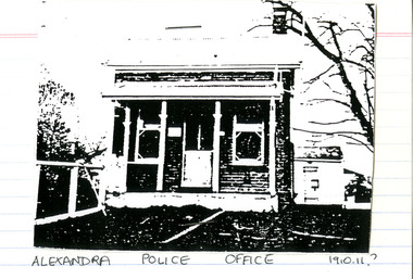
Police Stations (Alexandra)
... Alexandra is a regional centre in the Shire of Murrindindi in Victoria, Australia and 130 kilometres north east of Melbourne. Alexandra Police Station opened in the Benalla Police District on 8 May 1867 in Bon Street, on the north side near Grant Street. ...Victoria Police Museum 313 Spencer Street Docklands melbourne Alexandra is a regional centre in the Shire of Murrindindi in Victoria, Australia and 130 kilometres north east of Melbourne. Alexandra Police Station opened in the Benalla Police District on 8 May 1867 in Bon Street, on the north side near Grant Street. ...Alexandra is a regional centre in the Shire of Murrindindi in Victoria, Australia and 130 kilometres north east of Melbourne. Alexandra Police Station opened in the Benalla Police District on 8 May 1867 in Bon Street, on the north side near Grant Street. When the station opened it was staffed by one Senior Constable; one 1st Constable (Mounted); one Foot Constable. The original building was a nine-roomed brick building with an iron roof on land measuring 84' x 97’. The house included a wash-house, pantry, bathroom, office, one W.C., stabling for three horses, a lock-up with two rooms and a single man's room. It closed in June 1977 and was replaced by a new police station which opened on 16 June 1977 in Bon Street, on land adjacent to the old police station. For a list of Officers in Charge 1871 to 1943 contact Victoria Police Museum1 black and white photo and 3 colour photospolice stations; alexandra police station -
Marysville & District Historical Society
THE TRIANGLE NEWS-VOL 5 NO 30-OCTOBER 3 1980
... district brochure...marysville golf club...photographer...mountain views...happy birthday...think it over...bowls opening...betty's competition...jewellery for christ church stall...ladies' guild...birth...wirreanda-melbourne trail riding club...ruby anniversary...wirrianda appaloosa stud...blue hills riding school...north east...Marysville & District Historical Society 39 Darwin Street Marysville yarra-valley-and-the-dandenong-ranges marysville victoria australia planned district brochure marysville golf club photographer mountain views happy birthday think it over bowls opening betty's competition jewellery for christ church stall ladies' guild birth wirreanda-melbourne trail riding club ruby anniversary wirrianda appaloosa stud blue hills riding school north east poultry for sale senior citizens bush wackers ball marysville newsagency liberal party dinner marysville swimming & life saving club marysville primary school cricket club community care centre wirreanda parade footy poem new walking group THE TRIANGLE NEWS-VOL 5 NO 30-OCTOBER 3 1980 ...marysville, victoria, australia, planned district brochure, marysville golf club, photographer, mountain views, happy birthday, think it over, bowls opening, betty's competition, jewellery for christ church stall, ladies' guild, birth, wirreanda-melbourne trail riding club, ruby anniversary, wirrianda appaloosa stud, blue hills riding school, north east poultry, for sale, senior citizens, bush wackers ball, marysville newsagency, liberal party dinner, marysville swimming & life saving club, marysville primary school, cricket club, community care centre, wirreanda parade, footy poem, new walking group -
 Orbost & District Historical Society
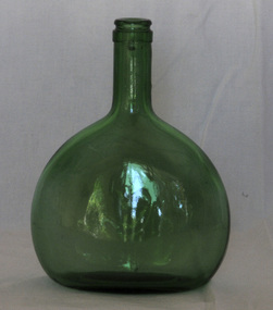
bottle
... Orbost & District Historical Society Ruskin Street Orbost gippsland The Bocksbeutel ("goat's bag") bottle has been used since 1726 to store Franconian wines from south-east Germany. The Franken wine-growing region is in the north ...The Bocksbeutel ("goat's bag") bottle has been used since 1726 to store Franconian wines from south-east Germany. The Franken wine-growing region is in the north-west of Germany’s historic state of Bavaria. More than 40% of all Franken wines are bottled in the Bocksbeutel, which is often described as flagon-like in appearance. It is said that the bottle is so shaped to prevent it rolling away from its owner. Only Franken and nearby villages in northern Badenare allowed to use the Bocksbeutal, with selected areas in Portugal, Italyand Greece permitted to employ their own variations. (ref www,winesearcher)A bocksbeutel - a a flagon-shaped wine bottle in the form of a flattened ellipsoid. It is a clear green glass bottle which is seamed.Base - 3 8A 313 700 mlsbottle beverage wines bocksbeutel franken-wines -
 Orbost & District Historical Society
plaque
... Originally part of the Bairnsdale district, Orbost split away as part of the Shire of Tambo in 1882, and became a Shire in its own right as the Shire of Croajingolong on the 30th may 1892. The name changed to the Shire of Orbost on 17 February 1893. Orbost was divided into four ridings on 31st May 1895, they were the North, South, East...Originally part of the Bairnsdale district, Orbost split away as part of the Shire of Tambo in 1882, and became a Shire in its own right as the Shire of Croajingolong on the 30th may 1892. The name changed to the Shire of Orbost on 17 February 1893. Orbost was divided into four ridings on 31st May 1895, they were the North, South, East ...The Coat of Arms of the Shire of Orbost has been designed in the form of a cross in which five stars are set on a shield. This was typical of those used by many shires and cities throughout Victoria and the Commonwealth. A small crown above the cross indicates the loyalty of the President, Councillors and Ratepayers to the reigning King or Queen. The inner circle of the shield contains four figures, a sheaf of wheat, a factory, a cow, and a ship, which represents the activities of agriculture, fishing, industry and dairying undertaken in the district. Originally part of the Bairnsdale district, Orbost split away as part of the Shire of Tambo in 1882, and became a Shire in its own right as the Shire of Croajingolong on the 30th may 1892. The name changed to the Shire of Orbost on 17 February 1893. Orbost was divided into four ridings on 31st May 1895, they were the North, South, East and Central riding, which was represented by three elected councillors. The Shire coat of arms was on the wall on the right of the front entrance to the building and was removed from the current building when Orbost Shire Council was amalgamated into East Gippsland Shire in 1994.The current building was opened on Friday 28th February 1969 by the Premier of Victoria, The Hon. Sir Henry E. Bolte, K.C.M.G., M.P. Local governments play an important role in the lives of citizens in Australia. Local government authorities exist to provide services and amenities to local communities, and are also responsible for regulating and providing services for land and property in their district. This item is representative of a time when Orbost had its own Shire Council. A large round metal plaque with the words SHIRE OF ORBOST1892 in gold letters around a crown and shield divided into four sections to represent four industries : Shipping ; farming - maize ; dairy and mining.SHIRE OF ORBOST 1892government orbost-shire-council coat-of-arms plaque -
 Bright & District Historical Society operating the Bright Museum
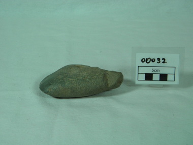
Axe, Stone, prior to 1860
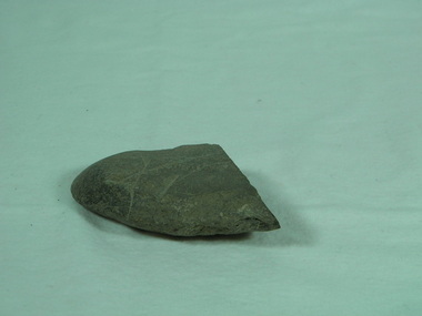
... Bright & District Historical Society operating the Bright Museum 2 Station Street Bright high-country Donated by Charles Willoughby who found the axe and two others on his farm on the site of the present Lake Buffalo. Aboriginal atrtefacts are relatively rare in the North Eastern Region. This is a well made axe. The location of the quartzite may be significant in showing regional affinities. axe aboriginal artefact buffalo river north east ...Donated by Charles Willoughby who found the axe and two others on his farm on the site of the present Lake Buffalo.Aboriginal atrtefacts are relatively rare in the North Eastern Region. This is a well made axe. The location of the quartzite may be significant in showing regional affinities.Quartzite ground edge stone axe with use polish on working edge and flaking on opposite edgeaxe, aboriginal artefact, buffalo river, north east region -
 Bright & District Historical Society operating the Bright Museum
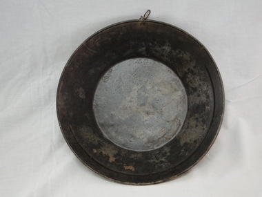
Pan gold
... District Historical Society operating the Bright Museum 2 Station Street Bright high-country Used for separating gold particles from alluvial deposits. After washing the alluvial gravel in water the gold is trapped in a ring on the side of the pan. This pan has a ring half way round the rim of the pan. Typical gold pan that would have been used in gold fields of North East ...Used for separating gold particles from alluvial deposits. After washing the alluvial gravel in water the gold is trapped in a ring on the side of the pan. This pan has a ring half way round the rim of the pan.Typical gold pan that would have been used in gold fields of North East VictoriaUsed gold pan. 300mm diametergold, gold pan, goldfields -
 Bright & District Historical Society operating the Bright Museum
Axe Stone
... Bright & District Historical Society operating the Bright Museum 2 Station Street Bright high-country Evidence of Aboriginal presence and activities in Buffalo River Valley near site of present Buffalo Dam. Evidence of Aboriginal presence and activities in North East ...Evidence of Aboriginal presence and activities in Buffalo River Valley near site of present Buffalo Dam.Evidence of Aboriginal presence and activities in North East and Alpine areas relatively uncommon.quartzite ground edge stone axe with edge damage axe, aboriginal artefact, buffalo river -
 Bright & District Historical Society operating the Bright Museum
Axe Stone
... Bright & District Historical Society operating the Bright Museum 2 Station Street Bright high-country Presence of Aboriginal people and their activities in Buffalo River Aboriginal axes are relatively uncommon in North East Victoria and provide evidence of presence and exploitation of resources axe aboriginal artefact buffalo river ground edge stone axe with some edge damage and edge polish on working edge and flat opposite edge. ...Presence of Aboriginal people and their activities in Buffalo RiverAboriginal axes are relatively uncommon in North East Victoria and provide evidence of presence and exploitation of resourcesground edge stone axe with some edge damage and edge polish on working edge and flat opposite edge. axe, aboriginal artefact, buffalo river -
 Eltham District Historical Society Inc
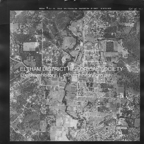
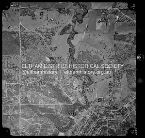
Photograph - Aerial Photograph, Landata, Eltham, Main Road; Mt Pleasant Rd to Railway Rd, Dec. 1945
... Eltham District Historical Society Inc 728 Main Rd Eltham melbourne Centred on Main Rd and Henry St, Eltham bounded by Railway Road to north, Mount Pleasant Road at Main Road to south, top of the hill in Arthur Street to east and Karingal Drive at Sherbourne Road to west. ...Centred on Main Rd and Henry St, Eltham bounded by Railway Road to north, Mount Pleasant Road at Main Road to south, top of the hill in Arthur Street to east and Karingal Drive at Sherbourne Road to west. Historic Aerial Imagery Source: Landata.vic.gov.au Aerial Photo Details: Project No :65 Project : MELBOURNE AND METROPOLITAN PROJECT NO. 2 Run : 8 Frame : 70 Date : 01/1951 Film Type : B/W Camera : EAG9 Flying Height : 12200 Scale : 12000 Film Number : 1419 GDA2020 : 37°43'06"S, 145°08'45"E MGA2020 : 336589, 5823811 (55) Melways : 21 J6 (ed. 42)aerial photo, eltham, main road, henry street, arthur street, bolton street, eltham-yarra glen road, neil webster collection, 1951-01, dave lyon house, ernie andrew house, karingal road, melway 21j6, mount pleasant road, railway road -
 Eltham District Historical Society Inc
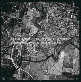
Photograph - Aerial Photograph, Landata, Eltham, Vic, Apr. 1963
... Eltham District Historical Society Inc 728 Main Rd Eltham melbourne Centred on present day Eltham Lower Park bounded by Brougham Street to north, Yarra River and Fitzsimons Lane Bridge to south, Main Road at Kent Hughes Road to east and Bolton Street to west. ...Centred on present day Eltham Lower Park bounded by Brougham Street to north, Yarra River and Fitzsimons Lane Bridge to south, Main Road at Kent Hughes Road to east and Bolton Street to west. Historic Aerial Imagery Source: Landata.vic.gov.au Aerial Photo Details: Project No :486 Project : MELBOURNE (1963) PROJECT Run : 7 Frame : 232 Date : 04/1963 Film Type : B/W Camera : RC8 Flying Height : 5100 Scale : 9600 Film Number : 1805 GDA2020 : 37°44'03"S, 145°08'33"E MGA2020 : 336329, 5822040 (55) Melways : 21 H10 (ed. 42)aerial photo, neil webster collection, 1963-04, bolton steet, brougham steet, eltham, eltham lower park, fitzsimons lane bridge, kent hughes road, melway 21h10, yarra river -
 Eltham District Historical Society Inc
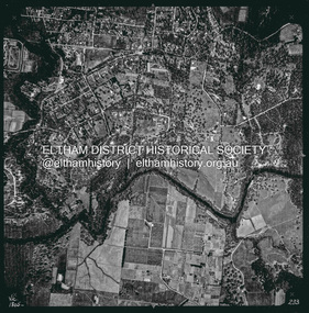
Photograph - Aerial Photograph, Landata, Eltham, Vic, Apr. 1963
... Eltham District Historical Society Inc 728 Main Rd Eltham melbourne Centred on present day Griffith Park Road, Eltham bounded by Mount Pleasant Road to north, Yarra River and Templestowe to south, Main Road at Reynolds Road to east and Falkiner Street to west. ...Centred on present day Griffith Park Road, Eltham bounded by Mount Pleasant Road to north, Yarra River and Templestowe to south, Main Road at Reynolds Road to east and Falkiner Street to west. Historic Aerial Imagery Source: Landata.vic.gov.au Aerial Photo Details: Project No :486 Project : MELBOURNE (1963) PROJECT Run : 7 Frame : 233 Date : 04/1963 Film Type : B/W Camera : RC8 Flying Height : 5100 Scale : 9600 Film Number : 1805 GDA2020 : 37°44'04"S, 145°09'10"E MGA2020 : 337237, 5822053 (55) Melways : 22 A10 (ed. 42)aerial photo, neil webster collection, 1963-04, eltham, falkiner street, griffith park road, melway 22a10, mount pleasant road, reynolds road, templestowe, yarra river -
 Eltham District Historical Society Inc
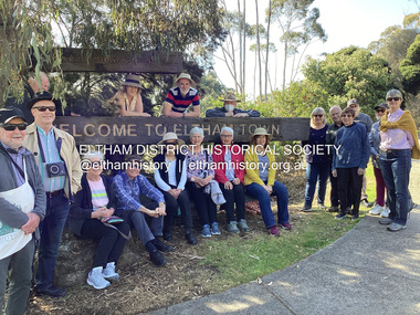
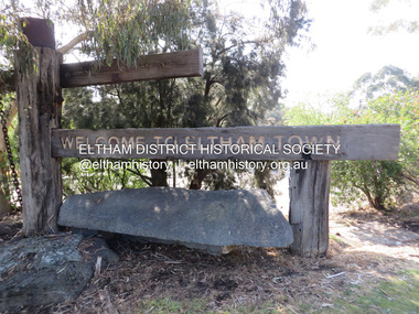
Photograph, Fay Bridge, EDHS Heritage Walk: Shillinglaw Farm, Eltham, 2 September 2023
... east of the Diamond Creek and north of Henry Street. A number of stops were made to look at maps and early photos illustrating the gradual reduction of the farm area and the early history of the railway and other community uses, that occupied parts of the site. Fay Bridge Collection 2023-09-02 Activities Eltham Eltham District ...On Saturday September 2, 2023, Russell Yeoman led a group of 22 society members and interested others on a walk following trhe bounadries of the original Shillingalw farm. Commencing at the corner of Panther Place and Library Place, we proceeded up to Shillinglaw Cafe then the Shillinglaw trees at the former Eltham Shire Office site then along Main Road to the fire station then throughh St Laurence Lane and uinder the railway line , along Diamond Street then return via the Diamond Creek trail behind Andrew Park. The actual farm boundary went past the creek and further up the hill. The original farm comprised lot 90 of Holloway’s 1851 subdivision of Little Eltham. Its area was 30 acres lying east of the Diamond Creek and north of Henry Street. A number of stops were made to look at maps and early photos illustrating the gradual reduction of the farm area and the early history of the railway and other community uses, that occupied parts of the site.fay bridge collection, 2023-09-02, activities, eltham, eltham district historical society, heritage excursion, shillinglaw farm -
 Eltham District Historical Society Inc
Photograph, Liz Pidgeon, EDHS Heritage Walk: Shillinglaw Farm, Eltham, 2 September 2023
... east of the Diamond Creek and north of Henry Street. A number of stops were made to look at maps and early photos illustrating the gradual reduction of the farm area and the early history of the railway and other community uses, that occupied parts of the site. 2023-09-02 Activities Eltham Eltham District Historical Society Heritage Excursion Shillinglaw farm 895 Main Road Amplifon Andrew Park Andrew Pocket Park Arthur Street Bar de Tapas Barber shop Barry Plant estate agent Blockbuster Bus depot Car Park Carparks Central Park Cleaver & Co Hair Commonwealth Bank Crust Pizza Divine Bridal Dr Ash Constance Dudley Street Eltham Book Shop Eltham Convenience Store Eltham Fire Station Eltham Library Eltham Newsagency Eltham Optical Eltham Railway Station Eltham Shops Fay Bridge Fire Bell Flagpole Flight Centre Grill'd Information sign ISO Chook Jellis Craig estate agent Judge Book Village Kebab Nation KX Pilates La Zanyas Liquorland Little Drop of Poison Lorraine Jones & Associates Solicitors Luck Street Machan Indian restaurant Main Road Mecho en Mexico Missing Gorilla Morrison Kleeman Real Estate Pavilion Menswear Platform 3095 Playtherapy Melbourne Pryor Street Ray White Real Estate Restaurants Sage Bulk Whole Foods Shillinglaw Trees Sign Snap Fitness Southern Cross Medical Imaging Specsavers St Laurence Lane St Vincents Care Service Thompson's Pharmacy Todaro United Service Station vyve body & skin Welcome to Eltham Town Westpac Bank Yang's Kitchen Youth Road 71 images - born digital EDHS Heritage Walk: Shillinglaw Farm, Eltham Photograph Photograph Liz Pidgeon ...On Saturday September 2, 2023, Russell Yeoman led a group of 22 society members and interested others on a walk following trhe bounadries of the original Shillingalw farm. Commencing at the corner of Panther Place and Library Place, we proceeded up to Shillinglaw Cafe then the Shillinglaw trees at the former Eltham Shire Office site then along Main Road to the fire station then throughh St Laurence Lane and uinder the railway line , along Diamond Street then return via the Diamond Creek trail behind Andrew Park. The actual farm boundary went past the creek and further up the hill. The original farm comprised lot 90 of Holloway’s 1851 subdivision of Little Eltham. Its area was 30 acres lying east of the Diamond Creek and north of Henry Street. A number of stops were made to look at maps and early photos illustrating the gradual reduction of the farm area and the early history of the railway and other community uses, that occupied parts of the site.2023-09-02, activities, eltham, eltham district historical society, heritage excursion, shillinglaw farm, 895 main road, amplifon, andrew park, andrew pocket park, arthur street, bar de tapas, barber shop, barry plant estate agent, blockbuster, bus depot, car park, carparks, central park, cleaver & co hair, commonwealth bank, crust pizza, divine bridal, dr ash constance, dudley street, eltham book shop, eltham convenience store, eltham fire station, eltham library, eltham newsagency, eltham optical, eltham railway station, eltham shops, fay bridge, fire bell, flagpole, flight centre, grill'd, information sign, iso chook, jellis craig estate agent, judge book village, kebab nation, kx pilates, la zanyas, liquorland, little drop of poison, lorraine jones & associates solicitors, luck street, machan indian restaurant, main road, mecho en mexico, missing gorilla, morrison kleeman real estate, pavilion menswear, platform 3095, playtherapy melbourne, pryor street, ray white real estate, restaurants, sage bulk whole foods, shillinglaw trees, sign, snap fitness, southern cross medical imaging, specsavers, st laurence lane, st vincents care service, thompson's pharmacy, todaro, united service station, vyve body & skin, welcome to eltham town, westpac bank, yang's kitchen, youth road -
 Eltham District Historical Society Inc
Photograph - Aerial Photograph, Landata, Eltham North, Vic, Apr. 1972
... Eltham District Historical Society Inc 728 Main Rd Eltham melbourne Centred on present day Eltham North reserve near Eltham North Primary School, Eltham North bounded by Allendale Road to north, Bellevue Road to south, Zig Zag Road and Beard Street to east and Ryans Road to west. ...Centred on present day Eltham North reserve near Eltham North Primary School, Eltham North bounded by Allendale Road to north, Bellevue Road to south, Zig Zag Road and Beard Street to east and Ryans Road to west. Historic Aerial Imagery Source: Landata.vic.gov.au Aerial Photo Details: Project No :985 Project : MELBOURNE 1972 Run : 26 Frame : 190 Date : 04/1972 Film Type : B/W Camera : RC10 Flying Height : 5700 Scale : 9600 Film Number : 2636 GDA2020 : 37°41'52"S, 145°08'52"E MGA2020 : 336705, 5826102 (55) Melways : 11 J12 (ed. 42)aerial photo, neil webster collection, 1972-04, allendale road, beard street, bellevue road, eltham, eltham north, eltham north reserve, melway 11j12, ryans road, zig zag road, eltham north primary school