Showing 72 items matching "one tree hill road"
-
 Eltham District Historical Society Inc
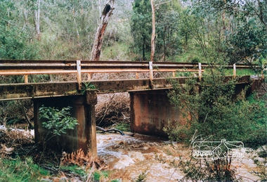
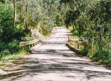
Photograph, One Tree Hill Road Bridge, Christmas Hills
... One Tree Hill Road Bridge, Christmas Hills......one tree hill road...Colour photograph of bridge over Watsons Creek, One Tree Hill Road, Christmas Hills...Eltham District Historical Society Inc 728 Main Rd Eltham melbourne bridges watsons creek one tree hill road christmas hills Colour photograph of bridge over Watsons Creek, One Tree Hill Road, Christmas Hills One Tree Hill Road Bridge, Christmas Hills Photograph ...Colour photograph of bridge over Watsons Creek, One Tree Hill Road, Christmas Hillsbridges, watsons creek, one tree hill road, christmas hills -
 Eltham District Historical Society Inc
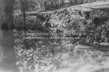
Negative - Photograph, J.A. McDonald, One Tree Hill Road Bridge, Christmas Hills, 2 July 1962
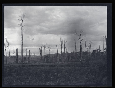
... One Tree Hill Road Bridge, Christmas Hills......One Tree Hill Road...One Tree Hill Road Looking south 2/7/62 The bridge was destroyed by bushfires 15-16 January 1962. ...Eltham District Historical Society Inc 728 Main Rd Eltham melbourne One Tree Hill Road Looking south 2/7/62 The bridge was destroyed by bushfires 15-16 January 1962. ...One Tree Hill Road Looking south 2/7/62 The bridge was destroyed by bushfires 15-16 January 1962. A temporary bridge was set up to the east sideRecord of various Shire of Eltham infrastructure works undertaken during the period of 1952-1962 involving bridge and road reconstruction projects, sometimes with Eltham Shire Council Project Reference numbers quoted. It was during this period that a number of significant improvements were made to roads and new bridges constructed within the shire that remain in place as of present day (2022). In many situations, the photos provide a tangible visible record of infrastructure that existed throughout the early days of the Shire. The album was put together by or under the direction of the Shire Engineer, J.A. McDonald.1962-07-02, bridge construction, christmas hills, infrastructure, shire of eltham, victorian bushfires - 1962, bush fires, one tree hill road, property damage -
 Eltham District Historical Society Inc
Photograph, Mineshaft Road at One Tree Hill Road, Smiths Gully, 6 December 1992, 06/12/1992
... Mineshaft Road at One Tree Hill Road, Smiths Gully, 6 December 1992......one tree hill road...Eltham District Historical Society Inc 728 Main Rd Eltham melbourne The Eltham Horse Trail: Research and Warrandyte to Kinglake: Survey of proposed route, December 1992: (3) Kangaroo Ground to Kinglake eltham horse trail (1992 survey) mineshaft road smiths gully one tree hill road Colour photograph Mineshaft Road at One Tree Hill Road, Smiths Gully, 6 December 1992 Photograph ...The Eltham Horse Trail: Research and Warrandyte to Kinglake: Survey of proposed route, December 1992: (3) Kangaroo Ground to KinglakeColour photographeltham horse trail (1992 survey), mineshaft road, smiths gully, one tree hill road -
 Eltham District Historical Society Inc
Photograph, Hairpin bend on One Tree Hill Road, Smiths Gully, 6 December 1992, 06/12/1992
... Hairpin bend on One Tree Hill Road, Smiths Gully, 6 December 1992......one tree hill road...Eltham District Historical Society Inc 728 Main Rd Eltham melbourne The Eltham Horse Trail: Research and Warrandyte to Kinglake: Survey of proposed route, December 1992: (3) Kangaroo Ground to Kinglake eltham horse trail (1992 survey) smiths gully one tree hill road Colour photograph Hairpin bend on One Tree Hill Road, Smiths Gully, 6 December 1992 Photograph ...The Eltham Horse Trail: Research and Warrandyte to Kinglake: Survey of proposed route, December 1992: (3) Kangaroo Ground to KinglakeColour photographeltham horse trail (1992 survey), smiths gully, one tree hill road -
 Eltham District Historical Society Inc
Photograph, Doug Orford, Bridge across Watsons Creek, One Tree Hill Road, Christmas Hills, 1991, 1991
... Bridge across Watsons Creek, One Tree Hill Road, Christmas Hills, 1991......one tree hill road...Eltham District Historical Society Inc 728 Main Rd Eltham melbourne From a collection of 35 photos taken by Doug Orford at 35 specific locations along the exact boundary of the then Shire of Eltham. watsons creek christmas hills bridges one tree hill road Colour photograph Bridge across Watsons Creek, One Tree Hill Road, Christmas Hills, 1991 Photograph Photograph Doug Orford ...From a collection of 35 photos taken by Doug Orford at 35 specific locations along the exact boundary of the then Shire of Eltham.Colour photographwatsons creek, christmas hills, bridges, one tree hill road -
 Eltham District Historical Society Inc
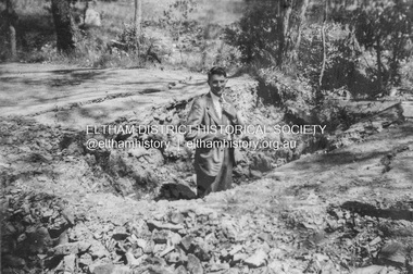
Album - Photograph, J.A. McDonald, Smiths Gully Road, Nov. 1952
... November 1952 Smiths Gully Road between Hall and One Tree Hill Road...Eltham District Historical Society Inc 728 Main Rd Eltham melbourne November 1952 Smiths Gully Road between Hall and One Tree Hill Road Record of various Shire of Eltham infrastructure works undertaken during the period of 1952-1962 involving bridge and road reconstruction projects, sometimes with Eltham Shire Council Project Reference numbers quoted. ...November 1952 Smiths Gully Road between Hall and One Tree Hill RoadRecord of various Shire of Eltham infrastructure works undertaken during the period of 1952-1962 involving bridge and road reconstruction projects, sometimes with Eltham Shire Council Project Reference numbers quoted. It was during this period that a number of significant improvements were made to roads and new bridges constructed within the shire that remain in place as of present day (2022). In many situations, the photos provide a tangible visible record of infrastructure that existed throughout the early days of the Shire. The album was put together by or under the direction of the Shire Engineer, J.A. McDonald.infrastructure, shire of eltham, bridge construction, road construction, 1952-11, smiths gully, smiths gully road -
 Eltham District Historical Society Inc
Album - Photograph, J.A. McDonald, Smiths Gully Road, Nov. 1952
... November 1952 Smiths Gully Road between Hall and One Tree Hill Road (D. Cole in foreground)...Eltham District Historical Society Inc 728 Main Rd Eltham melbourne November 1952 Smiths Gully Road between Hall and One Tree Hill Road (D. Cole in foreground) Record of various Shire of Eltham infrastructure works undertaken during the period of 1952-1962 involving bridge and road reconstruction projects, sometimes with Eltham Shire Council Project Reference numbers quoted. ...November 1952 Smiths Gully Road between Hall and One Tree Hill Road (D. Cole in foreground)Record of various Shire of Eltham infrastructure works undertaken during the period of 1952-1962 involving bridge and road reconstruction projects, sometimes with Eltham Shire Council Project Reference numbers quoted. It was during this period that a number of significant improvements were made to roads and new bridges constructed within the shire that remain in place as of present day (2022). In many situations, the photos provide a tangible visible record of infrastructure that existed throughout the early days of the Shire. The album was put together by or under the direction of the Shire Engineer, J.A. McDonald.infrastructure, shire of eltham, bridge construction, road construction, 1952-11, smiths gully, smiths gully road, d. cole -
 Eltham District Historical Society Inc
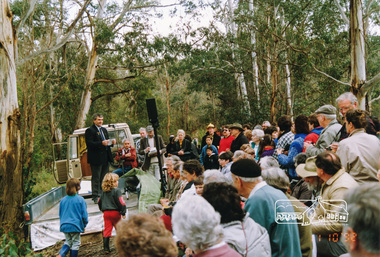
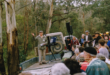
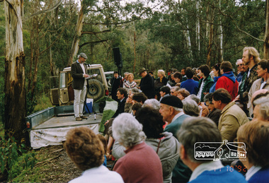
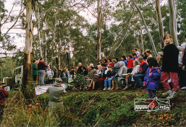
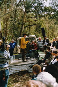
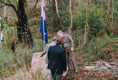
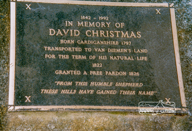
Photograph, Unveiling ceremony of a plaque in memory of David Christmas, 11 October 1992, 11/10/1992
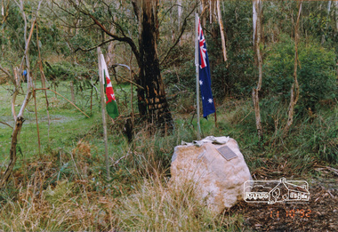
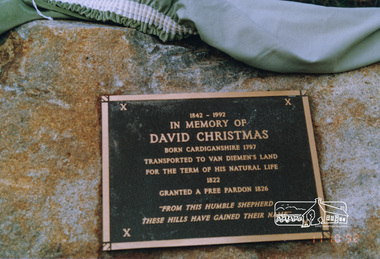
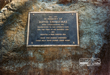
... The David Christmas memorial is situated on the south side of One Tree Hill Road, at Watsons Creek. As a young man, Welshman David Christmas had been transported to Van Dienman's Land for a relatively minor offence. ...Eltham District Historical Society Inc 728 Main Rd Eltham melbourne The David Christmas memorial is situated on the south side of One Tree Hill Road, at Watsons Creek. As a young man, Welshman David Christmas had been transported to Van Dienman's Land for a relatively minor offence. ...The David Christmas memorial is situated on the south side of One Tree Hill Road, at Watsons Creek. As a young man, Welshman David Christmas had been transported to Van Dienman's Land for a relatively minor offence. In 1836, having received a pardon, he came to Port Phillip, where, in 1842, he was hired as a shepherd by district pioneer, Joseph Stevenson. In 1992, a roadside plaque commemorating the shepherd who gave his name to the district was set in place over his presumed bush gravesite. The plaque was unveiled by two of Stevenson's grandsons, Bruce and Don Ness. FROM: Christmas Hills Past and Present, Yarra Glen & District Historical Society, 2004. The plaque reads: 1842-1992 In memory of David Christmas born Cardiganshire 1797 Transported to Van Dieman's Land for the term of his natural life 1822 Granted a free pardon 1826 "From this humble shepherd these hills have gained their name"Colour photographactivities, ceremonies, david christmas, memorials, unveiling ceremony, christmas hills, watsons creek -
 Eltham District Historical Society Inc
Photograph, Unveiling ceremony of a plaque in memory of David Christmas, 11 October 1992, 11/10/1992
... The David Christmas memorial is situated on the south side of One Tree Hill Road, at Watsons Creek. As a young man, Welshman David Christmas had been transported to Van Dienman's Land for a relatively minor offence. ...Eltham District Historical Society Inc 728 Main Rd Eltham melbourne The David Christmas memorial is situated on the south side of One Tree Hill Road, at Watsons Creek. As a young man, Welshman David Christmas had been transported to Van Dienman's Land for a relatively minor offence. ...The David Christmas memorial is situated on the south side of One Tree Hill Road, at Watsons Creek. As a young man, Welshman David Christmas had been transported to Van Dienman's Land for a relatively minor offence. In 1836, having received a pardon, he came to Port Phillip, where, in 1842, he was hired as a shepherd by district pioneer, Joseph Stevenson. In 1992, a roadside plaque commemorating the shepherd who gave his name to the district was set in place over his presumed bush gravesite. The plaque was unveiled by two of Stevenson's grandsons, Bruce and Don Ness. FROM: Christmas Hills Past and Present, Yarra Glen & District Historical Society, 2004. The plaque reads: 1842-1992 In memory of David Christmas born Cardiganshire 1797 Transported to Van Dieman's Land for the term of his natural life 1822 Granted a free pardon 1826 "From this humble shepherd these hills have gained their name"Colour photographactivities, ceremonies, david christmas, memorials, unveiling ceremony, ness family, watsons creek, christmas hills -
 Eltham District Historical Society Inc
Photograph, Unveiling ceremony of a plaque in memory of David Christmas, 11 October 1992, 11/10/1992
... The David Christmas memorial is situated on the south side of One Tree Hill Road, at Watsons Creek. As a young man, Welshman David Christmas had been transported to Van Dienman's Land for a relatively minor offence. ...Eltham District Historical Society Inc 728 Main Rd Eltham melbourne The David Christmas memorial is situated on the south side of One Tree Hill Road, at Watsons Creek. As a young man, Welshman David Christmas had been transported to Van Dienman's Land for a relatively minor offence. ...The David Christmas memorial is situated on the south side of One Tree Hill Road, at Watsons Creek. As a young man, Welshman David Christmas had been transported to Van Dienman's Land for a relatively minor offence. In 1836, having received a pardon, he came to Port Phillip, where, in 1842, he was hired as a shepherd by district pioneer, Joseph Stevenson. In 1992, a roadside plaque commemorating the shepherd who gave his name to the district was set in place over his presumed bush gravesite. The plaque was unveiled by two of Stevenson's grandsons, Bruce and Don Ness. FROM: Christmas Hills Past and Present, Yarra Glen & District Historical Society, 2004. The plaque reads: 1842-1992 In memory of David Christmas born Cardiganshire 1797 Transported to Van Dieman's Land for the term of his natural life 1822 Granted a free pardon 1826 "From this humble shepherd these hills have gained their name"Colour photographactivities, ceremonies, david christmas, memorials, unveiling ceremony, christmas hills, watsons creek -
 Eltham District Historical Society Inc
Photograph, Unveiling ceremony of a plaque in memory of David Christmas, 11 October 1992, 11/10/1992
... The David Christmas memorial is situated on the south side of One Tree Hill Road, at Watsons Creek. As a young man, Welshman David Christmas had been transported to Van Dienman's Land for a relatively minor offence. ...Eltham District Historical Society Inc 728 Main Rd Eltham melbourne The David Christmas memorial is situated on the south side of One Tree Hill Road, at Watsons Creek. As a young man, Welshman David Christmas had been transported to Van Dienman's Land for a relatively minor offence. ...The David Christmas memorial is situated on the south side of One Tree Hill Road, at Watsons Creek. As a young man, Welshman David Christmas had been transported to Van Dienman's Land for a relatively minor offence. In 1836, having received a pardon, he came to Port Phillip, where, in 1842, he was hired as a shepherd by district pioneer, Joseph Stevenson. In 1992, a roadside plaque commemorating the shepherd who gave his name to the district was set in place over his presumed bush gravesite. The plaque was unveiled by two of Stevenson's grandsons, Bruce and Don Ness. FROM: Christmas Hills Past and Present, Yarra Glen & District Historical Society, 2004. The plaque reads: 1842-1992 In memory of David Christmas born Cardiganshire 1797 Transported to Van Dieman's Land for the term of his natural life 1822 Granted a free pardon 1826 "From this humble shepherd these hills have gained their name"Colour photographactivities, ceremonies, david christmas, memorials, unveiling ceremony, ness family, christmas hills, watsons creek -
 Eltham District Historical Society Inc
Photograph, Unveiling ceremony of a plaque in memory of David Christmas, 11 October 1992, 11/10/1992
... The David Christmas memorial is situated on the south side of One Tree Hill Road, at Watsons Creek. As a young man, Welshman David Christmas had been transported to Van Dienman's Land for a relatively minor offence. ...Eltham District Historical Society Inc 728 Main Rd Eltham melbourne The David Christmas memorial is situated on the south side of One Tree Hill Road, at Watsons Creek. As a young man, Welshman David Christmas had been transported to Van Dienman's Land for a relatively minor offence. ...The David Christmas memorial is situated on the south side of One Tree Hill Road, at Watsons Creek. As a young man, Welshman David Christmas had been transported to Van Dienman's Land for a relatively minor offence. In 1836, having received a pardon, he came to Port Phillip, where, in 1842, he was hired as a shepherd by district pioneer, Joseph Stevenson. In 1992, a roadside plaque commemorating the shepherd who gave his name to the district was set in place over his presumed bush gravesite. The plaque was unveiled by two of Stevenson's grandsons, Bruce and Don Ness. FROM: Christmas Hills Past and Present, Yarra Glen & District Historical Society, 2004. The plaque reads: 1842-1992 In memory of David Christmas born Cardiganshire 1797 Transported to Van Dieman's Land for the term of his natural life 1822 Granted a free pardon 1826 "From this humble shepherd these hills have gained their name"Colour photographactivities, ceremonies, david christmas, memorials, unveiling ceremony, flags, christmas hills -
 Eltham District Historical Society Inc
Photograph, Unveiling ceremony of a plaque in memory of David Christmas, 11 October 1992, 11/10/1992
... The David Christmas memorial is situated on the south side of One Tree Hill Road, at Watsons Creek. As a young man, Welshman David Christmas had been transported to Van Dienman's Land for a relatively minor offence. ...Eltham District Historical Society Inc 728 Main Rd Eltham melbourne The David Christmas memorial is situated on the south side of One Tree Hill Road, at Watsons Creek. As a young man, Welshman David Christmas had been transported to Van Dienman's Land for a relatively minor offence. ...The David Christmas memorial is situated on the south side of One Tree Hill Road, at Watsons Creek. As a young man, Welshman David Christmas had been transported to Van Dienman's Land for a relatively minor offence. In 1836, having received a pardon, he came to Port Phillip, where, in 1842, he was hired as a shepherd by district pioneer, Joseph Stevenson. In 1992, a roadside plaque commemorating the shepherd who gave his name to the district was set in place over his presumed bush gravesite. The plaque was unveiled by two of Stevenson's grandsons, Bruce and Don Ness. FROM: Christmas Hills Past and Present, Yarra Glen & District Historical Society, 2004. The plaque reads: 1842-1992 In memory of David Christmas born Cardiganshire 1797 Transported to Van Dieman's Land for the term of his natural life 1822 Granted a free pardon 1826 "From this humble shepherd these hills have gained their name"Colour photographactivities, ceremonies, david christmas, memorials, unveiling ceremony, christmas hills, watsons creek, plaque -
 Eltham District Historical Society Inc
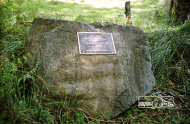
Photograph, David Christmas Memorial Plaque, Christmas Hills
... The David Christmas memorial is situated on the south side of One Tree Hill Road, at Watsons Creek. As a young man, Welshman David Christmas had been transported to Van Dienman's Land for a relatively minor offence. ...Eltham District Historical Society Inc 728 Main Rd Eltham melbourne The David Christmas memorial is situated on the south side of One Tree Hill Road, at Watsons Creek. As a young man, Welshman David Christmas had been transported to Van Dienman's Land for a relatively minor offence. ...The David Christmas memorial is situated on the south side of One Tree Hill Road, at Watsons Creek. As a young man, Welshman David Christmas had been transported to Van Dienman's Land for a relatively minor offence. In 1836, having received a pardon, he came to Port Phillip, where, in 1842, he was hired as a shepherd by district pioneer, Joseph Stevenson. In 1992, a roadside plaque commemorating the shepherd who gave his name to the district was set in place over his presumed bush gravesite. The plaque was unveiled by two of Stevenson's grandsons, Bruce and Don Ness. FROM: Christmas Hills Past and Present, Yarra Glen & District Historical Society, 2004. 1842-1992 In memory of David Christmas born Cardiganshire 1797 Transported to Van Dieman's Land for the term of thi natural life 1822 Granted a free pardon 1826 "From this humble shepherd these hills have gained their name" Colour photographdavid christmas, memorials, christmas hills, plaque, watsons creek -
 Eltham District Historical Society Inc
Photograph, David Christmas Memorial Plaque, Heritage Excursion, 22 October 1996, 22/10/1996
... The David Christmas memorial is situated on the south side of One Tree Hill Road, at Watsons Creek. As a young man, Welshman David Christmas had been transported to Van Dienman's Land for a relatively minor offence. ...Eltham District Historical Society Inc 728 Main Rd Eltham melbourne The David Christmas memorial is situated on the south side of One Tree Hill Road, at Watsons Creek. As a young man, Welshman David Christmas had been transported to Van Dienman's Land for a relatively minor offence. ...The David Christmas memorial is situated on the south side of One Tree Hill Road, at Watsons Creek. As a young man, Welshman David Christmas had been transported to Van Dienman's Land for a relatively minor offence. In 1836, having received a pardon, he came to Port Phillip, where, in 1842, he was hired as a shepherd by district pioneer, Joseph Stevenson. In 1992, a roadside plaque commemorating the shepherd who gave his name to the district was set in place over his presumed bush gravesite. The plaque was unveiled by two of Stevenson's grandsons, Bruce and Don Ness. FROM: Christmas Hills Past and Present, Yarra Glen & District Historical Society, 2004. The plaque reads: 1842-1992 In memory of David Christmas born Cardiganshire 1797 Transported to Van Dieman's Land for the term of his natural life 1822 Granted a free pardon 1826 "From this humble shepherd these hills have gained their name"Colour photographactivities, heritage excursion, david christmas, watsons creek, christmas hills, plaque -
 Eltham District Historical Society Inc
Photograph, In memory of David Christmas
... The David Christmas memorial is situated on the south side of One Tree Hill Road, at Watsons Creek. As a young man, Welshman David Christmas had been transported to Van Dienman's Land for a relatively minor offence. ...Eltham District Historical Society Inc 728 Main Rd Eltham melbourne The David Christmas memorial is situated on the south side of One Tree Hill Road, at Watsons Creek. As a young man, Welshman David Christmas had been transported to Van Dienman's Land for a relatively minor offence. ...The David Christmas memorial is situated on the south side of One Tree Hill Road, at Watsons Creek. As a young man, Welshman David Christmas had been transported to Van Dienman's Land for a relatively minor offence. In 1836, having received a pardon, he came to Port Phillip, where, in 1842, he was hired as a shepherd by district pioneer, Joseph Stevenson. In 1992, a roadside plaque commemorating the shepherd who gave his name to the district was set in place over his presumed bush gravesite. The plaque was unveiled by two of Stevenson's grandsons, Bruce and Don Ness. FROM: Christmas Hills Past and Present, Yarra Glen & District Historical Society, 2004. 1842-1992 In memory of David Christmas born Cardiganshire 1797 Transported to Van Dieman's Land for the term of his natural life 1822 Granted a free pardon 1826 "From this humble shepherd these hills have gained their name" Roll of 35mm colour negative film, 1 strip (2 frames)Fuji 200david christmas, christmas hills, memorials, watsons creek, plaque -
 Bendigo Historical Society Inc.
Photograph - Aerial photographs of parts of Bendigo 1934, 1934
... The photos cover the City Centre and are mainly of the goldfields on the south side of the city; the extent of which covers approximately the four corners of Myers Flat, Maiden Gully, Mandurang and One Tree Hill. Streets, roads and places of interest have been identified as best as possible in December 2023. ...The photos cover the City Centre and are mainly of the goldfields on the south side of the city; the extent of which covers approximately the four corners of Myers Flat, Maiden Gully, Mandurang and One Tree Hill. Streets, roads and places of interest have been identified as best as possible in December 2023. ...AERIAL SHOTS OF PARTS OF BENDIGO 1934 Catalogue No.10584 This document contains scans of a unique set of aerial photographs that were taken over the City of Bendigo on Friday 12th January 1934, at about midday. The photographs were commissioned by Bendigo Mines Limited during their exploration and mining program designed to revitalize the Bendigo Goldfield. The photographs were given to the Victorian Mines Department sometime in the 1950s. The photographs were taken at a relatively low level of about 4000 feet. This gives a very detailed picture of Bendigo as it was in the 1930s. The photos cover the City Centre and are mainly of the goldfields on the south side of the city; the extent of which covers approximately the four corners of Myers Flat, Maiden Gully, Mandurang and One Tree Hill. Streets, roads and places of interest have been identified as best as possible in December 2023. There are 44 maps, and each references the adjoining maps.Typed Notes with CD The CD is one of two and contains a set of 46 images: The folder named "High_Resolution_800dpi" contains the original digital files that were produced by scanning the photographic prints (About A3 size) at 800 dpi using a high quality, large pformat, roll scanner. These files may be too large for some computers. A second CD contains a direstory called "Low_Resolution_300dep" The images in the folder names "Low_Reolution_300dpr" have a lower resolution (300 dpi) and have been rotated 90 degrees clockwise so that the Northern margin of each image is a the top of the screen. Clive Willman Senior Geologist Geological Survey of Victoriahistory, bendigo, bendigo mines, bendigo maps, bendigo aerial photos -
 Bendigo Military Museum
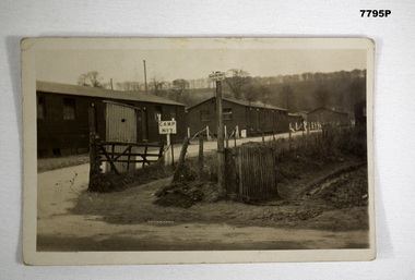
Postcard - POSTCARD - CODFORD AIF CAMP, UK, c1918
... road. Two signs appear in the foreground. One is labelled 'No. 7 Camp', the other taller one is labelled 'Salvation Army Rest Hut'. A tree lined hill...road. Two signs appear in the foreground. One is labelled 'No. 7 Camp', the other taller one is labelled 'Salvation Army Rest Hut'. A tree lined hill ...Photograph of AIF Codford Camp No. 7. R.H. Baron was stationed here in 1918 during WW1. He later transferred to Herdcott Camp. Part of the Robert H. Baron (No. 3596) and Cooper Collections. See Catalogue No. 1981P for details of Baron's service.Black and white photograph featuring three buildings fronting a gravel road. Two signs appear in the foreground. One is labelled 'No. 7 Camp', the other taller one is labelled 'Salvation Army Rest Hut'. A tree lined hill is in the background.On back, handwritten in black ink: 'Dear Mother, this is the entrance to our camp, the 3rd hut down on the outside is our hut, Robert H. Baron.robert h. baron, cooper collection, postcard, codford aif camp -
 Kiewa Valley Historical Society
Photographs – Set of 4 black and white photographs. One of a wooden church and three of rural homes and farmland. Area not identified
... road running through the middle. Foreground shows a field which has been semi cleared of trees (stumps remaining). In the background are larger farming properties with the road disappearing into the distant hills. This might be Old Tallangatta before the town was moved in 1956. Photographs – Set of 4 black and white photographs. One ...Europeans arrived in the Kiewa and Ovens Valleys in the 1830's and 40's. Following the drought of 1838-44, seeking out the rich pastures in the fertile Valleys. It proved to be perfect conditions for dairy farming and the raising of cattle. Miners Cottages and other similar wooden structures were a common sight in the area as they were a modest form of accommodation for their period, were quick to erect and economical as they made use of locally available building materials such as local timbers.These photographs provide a snapshot into the early dwellings and architecture of the Kiewa and Ovens Valley regions, including buildings such as the church, which provided an important gathering place for social interaction, especially in these isolated areas.1-Wooden church building with no identification. Large tree in the foreground in front of church 2&3- Black and white photographs of farmland and assorted dwellings, mostly miners style cottages in a valley with mountains in the background. A bridge with wooden railings is visible over the river in the middle of the photograph, also a more modern dwelling is visible in the north east of the photograph close to the river. 4-Black and white photograph of residential homes and farmland with an unsealed road running through the middle. Foreground shows a field which has been semi cleared of trees (stumps remaining). In the background are larger farming properties with the road disappearing into the distant hills. This might be Old Tallangatta before the town was moved in 1956. 1-3 - No inscriptions 4- Signature written on back in lead pencil - Sandra Templebuildings; church; farmland -
 Emerald Museum & Nobelius Heritage Park
Negative - Image of The Railway Line, Baker & Rouse, Early 20th century
... This one is of the Ferntree Gully to Gembrook railway line, which was completed in December 1900. The view looks northwards to the hills from probably present-day Station Road. This stark image of bare landscape with dead trees ...This negative is one of a batch of ten images taken apparently around the same time at Gembrook c. early 20th century. This one is of the Ferntree Gully to Gembrook railway line, which was completed in December 1900. The view looks northwards to the hills from probably present-day Station Road. This stark image of bare landscape with dead trees recalls both the early timber industry in Gembrook and the practice of wide-spread clearing of land for farming use.Black and white negative - landscape view - of the railway line at Gembrook. The railway is in the foreground. The landscape is bare apart from dead and ringbarked trees. Negative has been kept inside a packet which is not original.Handwritten on (not original) packet containing negative: 'Railway line & dead trees /Gembrook'gembrook, timber industry, railway, 1900, early 20th century, station rd -
 Emerald Museum & Nobelius Heritage Park
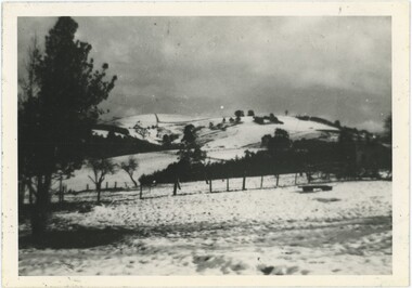
Photograph - Snow on John's Hill, 19/07/1951
... Road. Snow of this magnitude is very rare in Emerald (as it is in most of Victoria) - an image of a very significant snowfall is important and one of only a few similar days in the past century. Emerald 1950s Snow "Snow / Johns Hill / from [illegible] Rd 1951" This black and white photograph looks over a snow-covered field to a hill, similarly blanketed with snow interrupted by the occasional fence or tree, rising into the cloudy sky. ...On Thursday the 19th of July, 1951, Melbourne faced the most snow it had seen in twenty years as the city recorded temperatures as low as 37.9 F (approximately 3 C) at 1pm - with Emerald likely facing colder conditions. Snow fell across Victoria, blanketing Emerald - and in this picture, John's Hill - in rare layers of snowfall. While there isn't data for Emerald itself, the Dandenongs had two inches of snowfall while Yea saw a foot a 3pm. It appears Emerald was between these two amounts, though it is difficult to tell from only this photograph. The smudged annotations obscure where the photograph was taken from, although it was possibly Edenmont Road.Snow of this magnitude is very rare in Emerald (as it is in most of Victoria) - an image of a very significant snowfall is important and one of only a few similar days in the past century.This black and white photograph looks over a snow-covered field to a hill, similarly blanketed with snow interrupted by the occasional fence or tree, rising into the cloudy sky. There are some markings and scratches in the surface of the photograph. Some of the pencil handwriting on the reverse is smudged, obscuring the name of the road the photograph was taken from."Snow / Johns Hill / from [illegible] Rd 1951"emerald, 1950s, snow -
 Eltham District Historical Society Inc
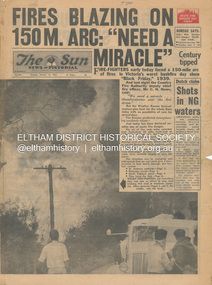
Newspaper - Newspaper articles, Sun News-Pictorial, Fires Blazing on 150M. Arc: "Need a Miracle", The Sun News-Pictorial, Tuesday, January 16, p1, 1962
... Road...Mt. Dandenong...Whittlesea...One Tree Hill...Hills Aflame: 2nd Day, pp16-17 (Illust.) • Respite at Olinda HQ, p16 (Illust.) • Here is Ruin, p17 (Illust.) • This fireman had to work among piled up furniture … p32 (Illust.) Tom Fielding Collection Victorian Bushfires - 1962 Victorian Bushfires – 1962 Black Friday Victorian Bushfires – 1939 C.H. Howe Daylesford Country Fire Authority Dandenongs Yallourn Central Gippsland Montrose Olinda Kalorama Healesville St. Andrews Hurstbridge Ninka Road Kinglake Yarra Glen A.L. McCutcheon St. Andrews Postmaster Eltham Shire Secretary Max Watson Police Commissioner Porter Observatory Road Mt. Dandenong Whittlesea One Tree ...Various news articles pertaining to the January 1962 Victorian bushfires in the Dandenong and Healesville districts which by second day had spread on to a 150 mile front fromDaylesford and Kinglake through to the Dandenongs. Specific Eltham Shire districts mentioned include Ninka Road, St. Andrews, Kinglake, Hurstbridge on page 2 • Fires Blazing on 150M. Arc: "Need a Miracle", p1 (Illust.) – Victoria’s worst bushfire day since “Black Friday,” 1939 • Night dash as bushfire sweeps by, p2 (Illust.) • Kalorama Saved: Fire 100 Ft. Away, p2 • Stay away, says police chief, p2 • The Tragedy of the Fires, p3 (Illust.) • Good save by firemen, p4 (Illust.) • S.E.C. Firemen Saved N. Yallourn, p4 • Cherry river of flame, p4 • From the fire front: Fire-fighters are bitten by snakes, p4 • They faced the fury, p6 (Illust.) • The ’39 Blaze, p6 • They fought and failed, p6 • Hills Aflame: 2nd Day, pp16-17 (Illust.) • Respite at Olinda HQ, p16 (Illust.) • Here is Ruin, p17 (Illust.) • This fireman had to work among piled up furniture … p32 (Illust.) tom fielding collection, victorian bushfires - 1962, victorian bushfires – 1962, black friday, victorian bushfires – 1939, c.h. howe, daylesford, country fire authority, dandenongs, yallourn, central gippsland, montrose, olinda, kalorama, healesville, st. andrews, hurstbridge, ninka road, kinglake, yarra glen, a.l. mccutcheon, st. andrews postmaster, eltham shire secretary, max watson, police commissioner porter, observatory road, mt. dandenong, whittlesea, one tree hill, sassafras, the basin, steel’s creek, ruby ryan, the basin progress hall, yaallourn, yallourn north, stet electricity commission (s.e.c.), hernes oak, mcdonalds track, florence milkins, lieutenant-colonel k. leggett, bonza view road, ringwood police station, michael o’connor, volunteers, fire damage - buildings -
 Eltham District Historical Society Inc
Photograph - Digital Photograph, Alan King, Panton Hill Hotel, 27 March 2008
... road dates from early last century, and has changed considerably. While most people searched for gold, the more enterprising ones established farms to feed the diggers. Farmers grew wheat, barley and oats, and sent animal skins to the Eltham tannery, to make furs in Melbourne. As gold became scarce from around 1880, miners took up farming on 19 to 20 acre (8ha) allotments. The first settlers in Cherry Tree Road included Purcell, Smith, Owens, Hughes and Shillinglaw. By 1900 all the land had been taken up around Panton Hill...road dates from early last century, and has changed considerably. While most people searched for gold, the more enterprising ones established farms to feed the diggers. Farmers grew wheat, barley and oats, and sent animal skins to the Eltham tannery, to make furs in Melbourne. As gold became scarce from around 1880, miners took up farming on 19 to 20 acre (8ha) allotments. The first settlers in Cherry Tree Road included Purcell, Smith, Owens, Hughes and Shillinglaw. By 1900 all the land had been taken up around Panton Hill ...Today’s Panton Hill Hotel was built around 1920. Published: Nillumbik Now and Then / Marguerite Marshall 2008; photographs Alan King with Marguerite Marshall.; p61 Panton Hill was originally known as Kingstown, and consisted of only one hotel when the Orams Reef was discovered in 1859. Kingstown was a quartz mining centre and many old mine shafts remain in the area. Orams Reef was one of the first reefs with a rich find of gold in the area. The Hotel Francais, which had been operating in 1861, was well situated on the way to Queenstown (later St Andrews). So was Herr Hirt’s Hotel and store at Smiths Gully. The Kingstown hotel, known as the Frenchman’s and in 1864 as the Hotel de France, was run by a Monsieur Emile Hude and his wife Jeanne, and known for its good food. They hosted social events, business conventions and debates, attracting patrons from as far as Melbourne. The hotel’s name was changed to Panton Hill Hotel in 1905. In 1883 Charles Caudwell built another hotel nearby, possibly in Long Gully Road,3 which it is thought, was burnt down early last century. Today’s Panton Hill Hotel, built around 1920, is the only one of the cluster of buildings in the main road, not to date from around the turn of last century. It was severely damaged by fire in 2003, then underwent extensive alterations. It is the township’s only hotel and is an example of a modest hotel building exterior, constructed early last century. In its early days the hotel also housed the first post office, newsagency and store. Orams Reef yielded a total of £100,000, and fossikers also found alluvial gold in the creeks and gullies, but there is no record of the total value of their finds. Gold greatly increased the Panton Hill population, which peaked between 1865 and 1885. On holidays large sports meetings were held with wood chopping contests and foot races and the day would end with a ball. Miners came from various countries to seek their fortune, including many from China. The Chinese became unpopular however, and gradually left the district, although some stayed and grew and sold vegetables.5 Panton Hill was named after Joseph Panton, who in 1862 was appointed Police Magistrate for the Woods Point, Heidelberg and Yarra districts. Panton was an outstanding man, who in 1852, was Commissioner of Crown Lands and Assistant Commissioner of Goldfields at Bendigo. In 1874 he was promoted to Chief Magistrate for the Melbourne Police. Panton was also an artist, becoming president of the Victorian Arts Society in 1888, and in 1913, president of the Royal Geographical Society. Despite Panton Hill’s prosperity, it still lacked many services as poor roads made access to Melbourne difficult. A horse-drawn mail coach travelled to Melbourne until 1890, when the railway came to Heidelberg. The nearest doctor was at Yarra Glen or Heidelberg, and the Indian hawker Singh’s annual visit was very welcome. A miner’s shack opposite the school was used as a post office. Today’s general store and post office in the main road dates from early last century, and has changed considerably. While most people searched for gold, the more enterprising ones established farms to feed the diggers. Farmers grew wheat, barley and oats, and sent animal skins to the Eltham tannery, to make furs in Melbourne. As gold became scarce from around 1880, miners took up farming on 19 to 20 acre (8ha) allotments. The first settlers in Cherry Tree Road included Purcell, Smith, Owens, Hughes and Shillinglaw. By 1900 all the land had been taken up around Panton Hill and Hurstbridge. The orchards in Panton Hill and the wider district, particularly of apple and pear, were very successful, and made Panton Hill a cohesive and successful community. About 1914 the Moores built the first cool-store and refrigeration plant at their orchard in Cherry Tree Road. Many settlers planted vineyards and made high quality wine, but in 1922 the blight destroyed them.This collection of almost 130 photos about places and people within the Shire of Nillumbik, an urban and rural municipality in Melbourne's north, contributes to an understanding of the history of the Shire. Published in 2008 immediately prior to the Black Saturday bushfires of February 7, 2009, it documents sites that were impacted, and in some cases destroyed by the fires. It includes photographs taken especially for the publication, creating a unique time capsule representing the Shire in the early 21st century. It remains the most recent comprehenesive publication devoted to the Shire's history connecting local residents to the past. nillumbik now and then (marshall-king) collection, panton hill hotel -
 Eltham District Historical Society Inc
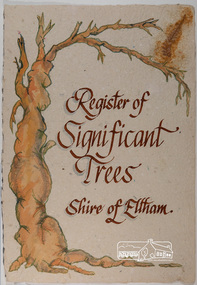
Work on paper - Folio, Register of Significant Trees, Shire of Eltham, c.1993
... The buildings and trees listed were: Buildings: 250 Bolton Street Eltham (former Walter Withers home) "Rosehill" - Bonds Road Lower Plenty St Andrews Church of England - St Andrews "Montsalvat" - Hillcrest Avenue Eltham St Margarets Church and former vicarage - Pitt Street Eltham Presbyterian Church - Kangaroo Ground Parks and Environment Office (former police quarters) Main Road Eltham Former Court House - Main Road Eltham "Shillinglaw Cottage" - Main Road Eltham "The Robins" - Kangaroo Ground Road Warrandyte Trees: "Donaldsons Oak" - Donaldsons Road Kangaroo Ground Yellow Box - Laughing Waters Road Eltham Yellow Box - Arthurs Creek Road Hurstbridge Wippells Oak - St Andrews Road Kanqaroo Road Pines and Cedar - Hurst family cemetery Greysharps Road Hurstbridge Yellow Box - Parsons Road Eltham A large Blue Gum at Panton Hill has been listed but has recently died (1991). In 1993 work by Council Parks and Environment staff and volunteers resulted in the preparation of a Significant Tree Register listing forty-one...The buildings and trees listed were: Buildings: 250 Bolton Street Eltham (former Walter Withers home) "Rosehill" - Bonds Road Lower Plenty St Andrews Church of England - St Andrews "Montsalvat" - Hillcrest Avenue Eltham St Margarets Church and former vicarage - Pitt Street Eltham Presbyterian Church - Kangaroo Ground Parks and Environment Office (former police quarters) Main Road Eltham Former Court House - Main Road Eltham "Shillinglaw Cottage" - Main Road Eltham "The Robins" - Kangaroo Ground Road Warrandyte Trees: "Donaldsons Oak" - Donaldsons Road Kangaroo Ground Yellow Box - Laughing Waters Road Eltham Yellow Box - Arthurs Creek Road Hurstbridge Wippells Oak - St Andrews Road Kanqaroo Road Pines and Cedar - Hurst family cemetery Greysharps Road Hurstbridge Yellow Box - Parsons Road Eltham A large Blue Gum at Panton Hill has been listed but has recently died (1991). In 1993 work by Council Parks and Environment staff and volunteers resulted in the preparation of a Significant Tree Register listing forty-one ...In 1983, the National Trust advised the Shire of Eltham that it was investigating a number of trees within the shire which had been nominated for recording the Register of Significant Trees of Victoria. The trees involved were described in the Shire of Eltham Historical Society Newsletter No. 29, March 1983 as follows:- 1. Eucalyptus melliadora (Yellow box) . a) An outstanding mature specimen 42 metres high in Laughing Waters Road, Eltham. b) Another mature specimen in Arthurs Creek road, Hurstbridge is reported to be the tree under which the bushranger Robert Bourke was tied after he shot and killed Henry Hurst in 1866 . 2. Quercus robur (English Oak). a) "Donaldson's Oak", Donaldsons Road, Kangaroo Ground was planted by John Donaldson from seed collected from Windsor Great Park in 1878. b) "Wippells Oak". This now misshapen tree is located on the St. Andrews Road near the Kangaroo Ground Fire Station. Its origins may have been similar to Donaldson's Oak, and as a young tree it apparently slipped from higher up the hill during wet weather. Both oaks are of local historical importance. 3. Eucalyptus globulus (Blue Gum). A large mature specimen at the corner of the Kangaroo Ground-St. Andrews Road and Bakehouse Road, Panton Hill. 4. Plantanas acerifolia (Plane tree) A number of trees forming the Avenue of Honour to Eltham's First World War soldiers along Main Road between Dalton and Pitt Streets, Eltham. 5. Pinus canariensis (Canary Island Pine), Pinus pinea, (Stone pine) and Cedras altlantica, (Cedar) These trees are located at the Hurst family graves in the grounds of the Hurstbridge Pre-school Centre. In 1991 the Shire of Eltham introduced controls into its planning scheme to protect sites of architectural, historic or conservation interest and significant trees. The controls were approved by the Minister for Planning and Housing. As advised in the Shire of Eltham Historical Society Newsletter No. 78, May 1991, a planning permit is required to demolish or alter any listed building or to destroy, lop or remove any listed tree. Provision is made for comments to be obtained from the National Trust or Historic Buildings Council in considering any applications. The buildings and trees listed were: Buildings: 250 Bolton Street Eltham (former Walter Withers home) "Rosehill" - Bonds Road Lower Plenty St Andrews Church of England - St Andrews "Montsalvat" - Hillcrest Avenue Eltham St Margarets Church and former vicarage - Pitt Street Eltham Presbyterian Church - Kangaroo Ground Parks and Environment Office (former police quarters) Main Road Eltham Former Court House - Main Road Eltham "Shillinglaw Cottage" - Main Road Eltham "The Robins" - Kangaroo Ground Road Warrandyte Trees: "Donaldsons Oak" - Donaldsons Road Kangaroo Ground Yellow Box - Laughing Waters Road Eltham Yellow Box - Arthurs Creek Road Hurstbridge Wippells Oak - St Andrews Road Kanqaroo Road Pines and Cedar - Hurst family cemetery Greysharps Road Hurstbridge Yellow Box - Parsons Road Eltham A large Blue Gum at Panton Hill has been listed but has recently died (1991). In 1993 work by Council Parks and Environment staff and volunteers resulted in the preparation of a Significant Tree Register listing forty-one trees or groups of trees. According to Shire of Eltham Historical Society Newsletter No. 91, March 1993, a similar number remained to be assessed for inclusion in the register. There is a wide range of indigenous and planted trees on private and public land and extending through the Shire of Eltham from Lower Plenty to Kinglake. Most can be viewed from publicly accessible locations. The Significant Tree Register lists 41 trees or groups of trees throughout the Shire. It contains a wide range of naturally occurring and planted trees. They have been assessed according to eleven criteria including size, age, rarity, historical value and the like. The list includes large old Red Gums at Lower Plenty, historic Oaks at Kangaroo Ground and Mountain Ash at Kinglake. The register includes a set of slides showing each tree. Garry Bartlett of the Council's Parks and Environment Section and Faye Shepherd were extensively involved in establishment of the register (Newsletter No. 93, November 1993). In 1999 Niliumbik planners prepared an amendment to the Planning Scheme to provide protection for approximately 200 of the places listed in the heritage studies and also in the Significant Tree Register commenced by the Eltham Council (Eltham District Historical Society Newsletter No. 127, July 1999. In 2004, The Register of Significant Trees was presented to the Eltham District Historical Society by Nillumbik Shire Council as part of a wider collection of of its memorabilia of the former Eltham Shire Council (EDHS Newsletter No. 159, July 2004. Album of loose handmade paper sheets contained within a handmade slip cover constructed of handcrafted card with encapsulated flora material (flowers, vines, ferns) and tinted. Each page also contains an embedded/adhered fern leaf also tinted with lacqueur or similar, text as appropriate in ink by hand calligraphy. Each page also has a white protective sheet cut to size and adhered to back surface with sticky tape and folded over face of page. Pages variously have photographs and coloured masks adhered with a gum resin. Over time much of this resin has let go and photos/masks have been reattached using acid free archival safe adhesive. 15 pages 41 x 29 cm inclusive of 3 blank pages. Slip case 42 x 30 x 1 cm; face cover of slip case has broken off at left hand margin as insufficient depth/flexibility for contents.arthurs creek road, blue gum (eucalyptus globulus), canary island pine (pinus canariensis), couties road, donaldsons oak, donaldsons road, eltham, english oak (quercus robur), eucalyptus melliodora, graysharps road, hurst tree, hurstbridge, ironbark (eucalyptus tricarpa), ironbark hill, kangaroo ground, kangaroo ground-kinglake road, laughing waters road, panton hill hotel, panton hill, parsons road, significant trees register, sonia van bodegraven, sonjart, stone pine (pinus pinea). atlantic cedar (cedrus atlantica), wippells oak, yellow box gum (eucalyptus melliodora), yellow box gum -
 Eltham District Historical Society Inc
Photograph - Colour Print, Janefield, Bundoora, c.1982
... Road. He retired when the school closed around 1993. Mick pointed out the location of three remnant farm houses of the 1800s. The Brock House being the main one. Peter has been unable to find any photos of the Brock House, which what built in the late 1850s, severely burnt in the 1930s and demolished in the mid 1960s. The tree plantation along Plenty Road was established in 1930 and cut down in the mid 1980s. The Victorian Government established tree plantations at about 350 schools in the early 1930s. Briar Hill...Road. He retired when the school closed around 1993. Mick pointed out the location of three remnant farm houses of the 1800s. The Brock House being the main one. Peter has been unable to find any photos of the Brock House, which what built in the late 1850s, severely burnt in the 1930s and demolished in the mid 1960s. The tree plantation along Plenty Road was established in 1930 and cut down in the mid 1980s. The Victorian Government established tree plantations at about 350 schools in the early 1930s. Briar Hill ...The photo encompasses what is present-day University Hill shopping complex and the Janefield Wetlands. Plenty Road is just visible to the left of the photo. Janefield was an area 18 km north-east of central Melbourne that is now part of Bundoora. In 1842 a flour mill, powered by the Plenty River, was built at Janefield, although the locality was not known by that name at that time. It seems that the name Springfield was used in the late 1840s, after a Springfield homestead, and this was changed to Janefield possibly upon the death of Jane Brock in 1847. She was the wife of James Brock, a local landowner and son of the purchaser of the flour mill. This photo is not strictly within the area of interest for EDHS but overlaps do occur at times with other Society’s interests through families and other associated connections. Eltham District Historical Society member (and Greensborough Historical Society member), Peter Van Eeken was undertaking research into this photo and approached the Local History Librarian at Yarra Plenty Regional Library to enquire about digitising the large print copy to facilitate research. Approaches were made to EDHS who had suitable facilities and were willing to accommodate and all parties agreed to add the image as part of their respective collections in partnership. Michael Lanigan, started work as a message boy at Mont Park when he left school at age 14. He worked his way up the system to become farm manager at Mont Park and Janefield Special School. He was one of the last people to drive a herd of cattle (in 1964) between the two locations along Plenty Road. He retired when the school closed around 1993. Mick pointed out the location of three remnant farm houses of the 1800s. The Brock House being the main one. Peter has been unable to find any photos of the Brock House, which what built in the late 1850s, severely burnt in the 1930s and demolished in the mid 1960s. The tree plantation along Plenty Road was established in 1930 and cut down in the mid 1980s. The Victorian Government established tree plantations at about 350 schools in the early 1930s. Briar Hill School had one but Peter is not sure about any other local schools having a tree plantation. Mick informed Peter that it was his job to remove the 14 acres of pine tree roots, after the trees were cut down (due to old age and an infestation of sap sucking insects). For Mick, this was an impossible job, so he arranged a contract, to house all the soil removed from works associated with the construction of the Greensborough Bypass, which needed temporary storage as it was too valuable, and would be great for use in road construction. The contract to store the soil was important to Mick, as the contract stipulated that when the soil was eventually removed, the tree roots had to be removed too. Which got rid of Mick's headache. Apparently, the huge mound of soil that covered the roots in the late 1980s could be seen from Briar Hill. Based on this, the photo is most likely to have been taken 1982 or 1983. The key to a final date is working out when the Board of Works Office opened but so far no information has come to light. (It was purchased by La Trobe University in 1991). The Office existed, or is hinted at, in the photo at the extreme north of the photo, opposite McKimmies Road, on the eastern side of Plenty Road. Photo on loan from Michael Lanigan via Peter Van Eeken. He cannot recall why it was taken. brock family, janefield, janefield drive, janefield wetlands, plenty road, university hill -
 Eltham District Historical Society Inc
Photograph - Digital Photograph, Alan King, Panton Hill Primary School, 27 March 2008
... one of Victoria’s most influential educational reformers. It was his first school, when he began teaching on January 22, 1884, as a 20 year old.5 The following month Robert J Harris was appointed to the school and remained as head teacher until his death in 1887. His son R C Harris was apprenticed to Mr Rossiter, editor of the first local paper. The Evelyn Observer, first published in 1873. Harris later bought the newspaper which remained a family business until the 1920s. J Hughes of Cherry Tree Road succeeded Harris as teacher at Panton Hill...one of Victoria’s most influential educational reformers. It was his first school, when he began teaching on January 22, 1884, as a 20 year old.5 The following month Robert J Harris was appointed to the school and remained as head teacher until his death in 1887. His son R C Harris was apprenticed to Mr Rossiter, editor of the first local paper. The Evelyn Observer, first published in 1873. Harris later bought the newspaper which remained a family business until the 1920s. J Hughes of Cherry Tree Road succeeded Harris as teacher at Panton Hill ...The Panton Hill Primary School building, which has served the community since 1889, was not the area's first. Kingston School (an early name for Panton Hill) opened in May 1865. This was replaced in 1871 when the Panton Hill School number 1134 opened and in 1874 the school moved to its current location [September 2023] where many additions and renovations have taken place to meet the needs of local children in the 21st century. Covered under Heritage Overlay, Nillumbik Planning Scheme. Published: Nillumbik Now and Then / Marguerite Marshall 2008; photographs Alan King with Marguerite Marshall.; p63 The Panton Hill Primary School building, which has served the community since 1889, was not the area’s first. In 1871 Henry Edelman opened a Common School in a paling-clad hut, replacing the Kingstown No 786 school. The two-acre (0.8ha) site of crown land had previously been held under Miners Right. In 1875 the Education Department bought a building on the main road for State School No 1134, for £200 and remodelled it as a school.4 Panton Hill had as one of its teachers, Frank Tate, who was to become one of Victoria’s most influential educational reformers. It was his first school, when he began teaching on January 22, 1884, as a 20 year old.5 The following month Robert J Harris was appointed to the school and remained as head teacher until his death in 1887. His son R C Harris was apprenticed to Mr Rossiter, editor of the first local paper. The Evelyn Observer, first published in 1873. Harris later bought the newspaper which remained a family business until the 1920s. J Hughes of Cherry Tree Road succeeded Harris as teacher at Panton Hill and sold his land for the school site. Though now unrecognisable, the school building includes the classroom of the last Smiths Gully State School No 1737, which was built in 1882, and moved to Panton Hill in 1894. From 1922 each school day began with the ringing of the bell, which is still in its stand, and is an unusually old memorial of this kind. To accommodate the growing population, the building was remodelled, with additions in 1923 and classrooms were added in 1955, 1963 and 1970. The former teacher’s residence is the only surviving 19th century dwelling in the centre of Panton Hill, and is now used as part of the school. The residence was originally rectangular but is now L-shaped. Similar weatherboard State School buildings in the shire from this period are the Kangaroo Ground and the St Andrews Primary Schools. All were standard Education Department/Public Works Department designs.This collection of almost 130 photos about places and people within the Shire of Nillumbik, an urban and rural municipality in Melbourne's north, contributes to an understanding of the history of the Shire. Published in 2008 immediately prior to the Black Saturday bushfires of February 7, 2009, it documents sites that were impacted, and in some cases destroyed by the fires. It includes photographs taken especially for the publication, creating a unique time capsule representing the Shire in the early 21st century. It remains the most recent comprehenesive publication devoted to the Shire's history connecting local residents to the past. nillumbik now and then (marshall-king) collection, panton hill primary school -
 Eltham District Historical Society Inc
Photograph - Digital Photograph, Alan King, Pigeon Bank, Kangaroo Ground-Warrandyte Road, Kangaroo Ground, 6 February 2008
... Road, Kangaroo Ground, is one of the Shire’s oldest farm dwellings, and has been home to some of the district’s earliest and most distinguished families. Although close to the road, the white weatherboard Victorian farmhouse is ensured privacy by the trees and hedges around it. On 4.8 hectares of farmland, Pigeon Bank is surrounded by rolling hills...Road, Kangaroo Ground, is one of the Shire’s oldest farm dwellings, and has been home to some of the district’s earliest and most distinguished families. Although close to the road, the white weatherboard Victorian farmhouse is ensured privacy by the trees and hedges around it. On 4.8 hectares of farmland, Pigeon Bank is surrounded by rolling hills ...In 1848, Francis Rogerson form Dumfriesshire, Scotland purchased 80 acres of land at Kangaroo Ground on which he built a two-roomed bark hut. He named the property afterr the many Bronzewings and Wonga Pigeons in the area. Ewen Hugh Cameron moved to Pigeon Bank the same year he was elected to Parliament as the Member for Evelyn. At the time he moved in, Pigeon Bank had six rooms and the present water well. He made further extensive additions and lived there until his death in 1915. Covered under Heritage Overlay, Nillumbik Planning Scheme. Published: Nillumbik Now and Then / Marguerite Marshall 2008; photographs Alan King with Marguerite Marshall.; p27 Pigeon Bank, on the Kangaroo Ground – Warrandyte Road, Kangaroo Ground, is one of the Shire’s oldest farm dwellings, and has been home to some of the district’s earliest and most distinguished families. Although close to the road, the white weatherboard Victorian farmhouse is ensured privacy by the trees and hedges around it. On 4.8 hectares of farmland, Pigeon Bank is surrounded by rolling hills, farmland and bush, the peace of which is punctuated by an occasional birdcall. Pigeon Bank’s first owner was Francis Rogerson, from Dumfriesshire, Scotland, who bought 80 acres (32.4ha) of land in 1848 on which he built a two-roomed bark hut. Today this is the centre piece of the 14-room home.1 Rogerson lined the rooms with tongue-and-groove boards and roofed them with wooden shingles and sapling frames, which remain under the present green corrugated iron roof. He named Pigeon Bank after the many forest bronzewing and Wonga Pigeons in the area at the time, and the name Bank was commonly used in Scotland. Rogerson was united with one of the oldest families in the area when his sister Janet married John Bell, son of William, the original Bell settler. When Ewen Cameron moved to Pigeon Bank in 1874 it had six rooms and the present water well. He made extensive additions to the house and farm buildings and lived at Pigeon Bank until his death in 1915. Cameron, who had arrived in Melbourne from Scotland in 1853, contributed an enormous amount to the community. He worked as a builder, as a miner at Andersons Creek, a storekeeper at Queenstown2 and as the first postmaster at Warrandyte. In 1867 he married Agnes Bell, daughter of local farmer, John Bell. Cameron was a member of the Eltham Road Board (which preceded the Shire Council) and for more than 50 years, from 1863, he was an Eltham Shire Councillor, being President three times. Cameron was the Member for Evelyn for 40 years from 1874. In the 1880s he became the Government Whip, in 1902 the Minister for Mines and Water Supply, and in 1904, the Minister for Health, Cameron was also an outstanding farmer, whose farm won the Agricultural Department prize for the finest in the district, three consecutive times. Not surprisingly Pigeon Bank became the centre of district life. Every New Year’s Eve, Cameron hired a highland piper, who marched from the Kangaroo Ground school house to Pigeon Bank playing his pipes.3 Distinguished visitors included opera singer, Dame Nellie Melba, Victorian Premier, Thomas Bent, Governor, Lord Hopetoun and artist, Longstaff. Following Cameron’s death, the property changed hands several times, then returned to the family in 1919 when bought by Gordon Cameron. As the car took over from the horse, Pigeon Bank entered difficult times because the farm had produced chaff and oats and bred Clydesdales and harness ponies. In 1926 Mr Matthews bought the property and made many alterations including pulling down the kitchen, which had been separate from the main house. The property again changed hands several times. One owner was Senator James F Guthrie, who added a sunroom. In 1968 the house again returned to the Cameron family, when Vera Jackson, a grand-daughter of Ewen Cameron, and her husband, bought the property. The Bishop family, who were sixth and seventh generation Bells and also descended from the Camerons, restored the house in the 1980s. Today tongue-and-groove boards still line part of the hall (which retains two fine arches), the breakfast room, and Ewen Cameron’s former room. Five original fireplaces in the bed and living rooms are still in working order. The wide veranda with a curved iron roof and ornate iron lace work bounds three sides of the house, and nearby a windmill stands beside the water well. Sue and Ron James, who bought the property in 2001, made extensive improvements to the homestead and meticulously restored the grounds to their original state.This collection of almost 130 photos about places and people within the Shire of Nillumbik, an urban and rural municipality in Melbourne's north, contributes to an understanding of the history of the Shire. Published in 2008 immediately prior to the Black Saturday bushfires of February 7, 2009, it documents sites that were impacted, and in some cases destroyed by the fires. It includes photographs taken especially for the publication, creating a unique time capsule representing the Shire in the early 21st century. It remains the most recent comprehenesive publication devoted to the Shire's history connecting local residents to the past. nillumbik now and then (marshall-king) collection, ewen hugh cameron, francis rogerson, kangaroo ground, kangaroo ground-warrandyte road, pigeon bank -
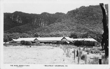 Halls Gap & Grampians Historical Society
Postcard, 03/04/1942
... Road Halls Gap grampians This photograph is the same one printed in 1925 soon after 'Bellfield' became a licenced hotel. Unfinished letter on reverse side indicates that at least 2 postcards were sent to the same recipient Reads as: "Belfield Hotel Grampians 3/4/42 Dear Mother, Well here we are once more amongst the Gum trees and believe me it is great to smell the fresh air once more after so long with the Rubber trees. We are right in the hills ...This photograph is the same one printed in 1925 soon after 'Bellfield' became a licenced hotel. Unfinished letter on reverse side indicates that at least 2 postcards were sent to the same recipient Reads as: "Belfield Hotel Grampians 3/4/42 Dear Mother, Well here we are once more amongst the Gum trees and believe me it is great to smell the fresh air once more after so long with the Rubber trees. We are right in the hills with towering mountains on the East and West and after the way the wind blew through gap last night, I would not be at all surprised if that were not the method by which the Gap were made. Several times last night we thought the roof would blow off and now I have cut pegs for the window I hope the rattle does not annoy us anymore. It took us until nearly five to get here last night but of course we did not find the time dragging on our hands. At Ballarat we made a rush for some lunch just got it back to the carriage when the waitress came round for"Photograph shows front of building with Wonderland Range behind handwritten letter on reverse side dated 03/4/42Rose Series P 4914accommodation, hotels, bellfield