Showing 2555 items matching "parishes"
-
 Whitehorse Historical Society Inc.
Map, Parishes of Bulleen, Boroondara, Prahran and Nunawading, 1850
... Parishes of Bulleen, Boroondara, Prahran and Nunawading...Allotments in the Parish surveyed by Lindsay Clarke 1850 (note by Robert Hoddle, surveys by Unwin, Elgar and Dendy indicated)...Allotments in the Parish surveyed by Lindsay Clarke 1850 (note by Robert Hoddle, surveys by Unwin, Elgar and Dendy indicated)...Allotments in the Parish surveyed by Lindsay Clarke 1850 (note by Robert Hoddle, surveys by Unwin, Elgar and Dendy indicated) Maps Parish of Bulleen Parish of Boroondara Parish of Prahran Parish of Nunawading Clarke Lindsay Hoddle Robert Photocopy of map and tables of corners of allotments. ...Photocopy of map and tables of corners of allotments.Photocopy of map and tables of corners of allotments. Note on verso: Nunawading, Boroondara, Prahran. Allotments in the Parish surveyed by Lindsay Clarke 1850 (note by Robert Hoddle, surveys by Unwin, Elgar and Dendy indicated)Photocopy of map and tables of corners of allotments. maps, parish of bulleen, parish of boroondara, parish of prahran, parish of nunawading, clarke, lindsay, hoddle, robert -
Stawell Historical Society Inc
Map, Agricultural Area of Lake Wilson, Parishes of Bellaura & Bellellen, 1865
... Agricultural Area of Lake Wilson, Parishes of Bellaura & Bellellen...Agricultural Area of Lake Wilson, Parishes of Bellaura & Bellellen...Stawell Historical Society Inc 46 Longfield St Stawell grampians Stawell Agricultural Area of Lake Wilson, Parishes of Bellaura & Bellellen Agricultural Area of Lake Wilson, Parishes of Bellaura & Bellellen Map ...Agricultural Area of Lake Wilson, Parishes of Bellaura & Bellellenstawell -
Stawell Historical Society Inc
Map, Country Lands Parishes of Drung Drung & Golton Golton, 1866
... Country Lands Parishes of Drung Drung & Golton Golton ...Country Lands Parishes of Drung Drung & Golton Golton ...Stawell Historical Society Inc 46 Longfield St Stawell grampians Stawell Country Lands Parishes of Drung Drung & Golton Golton Country Lands Parishes of Drung Drung & Golton Golton Map ...Country Lands Parishes of Drung Drung & Golton Golton stawell -
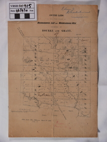
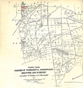
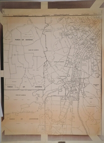
 Ringwood and District Historical Society
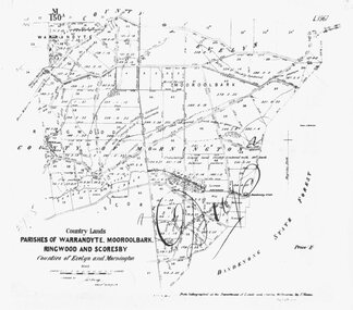
Map, Map showing Parishes of Warrandyte, Mooroolbark, Ringwood and Scoresby. 1870
... Map showing Parishes of Warrandyte, Mooroolbark, Ringwood and Scoresby. 1870....Written on front of map: "Country Lands. Parishes of Warrandyte, Mooroolbark, Ringwood and Scoresby. ...Written on front of map: "Country Lands. Parishes of Warrandyte, Mooroolbark, Ringwood and Scoresby. ...Black and white copy of mapWritten on front of map: "Country Lands. Parishes of Warrandyte, Mooroolbark, Ringwood and Scoresby. Counties of Evelyn an Mornington." -
 Ringwood and District Historical Society
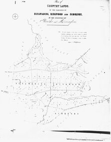
Map, Plan of Country Lands, in the Parishes of Nunawading, Ringwood and Scoresby. c1870
... Plan of Country Lands, in the Parishes of Nunawading, Ringwood and Scoresby. c1870....Written on front of map: " Plan of Country Lands, in the Parishes of Nunawading, Ringwood and Scoresby, in the Counties of Bourke and Mornington."...Black and white copy of map Plan of Country Lands, in the Parishes of Nunawading, Ringwood and Scoresby. c1870. ...Black and white copy of mapWritten on front of map: " Plan of Country Lands, in the Parishes of Nunawading, Ringwood and Scoresby, in the Counties of Bourke and Mornington." -
 Ringwood and District Historical Society
Map, Early map of Parishes of Ringwood and Warrandyte in Counties of Evelyn and Mornington - c.1868, 1868
... Early map of Parishes of Ringwood and Warrandyte in Counties of Evelyn and Mornington - c.1868...Vol. 5, Fol.13/1224." (From Parish Map collection)...Early map of Parishes of Ringwood and Warrandyte in Counties of Evelyn and Mornington - c.1868 Map ...Black and white hand drawn map of Ringwood and Warrandyte areas.Map surveyed by M. Callanan, Assistant Surveyor. Written on rear of backing sheet: "c1868. Vol. 5, Fol.13/1224." (From Parish Map collection) -
Port Melbourne Historical & Preservation Society
Map, City of Port Melbourne. Parishes of melbourne South. Doutta Galla, c. 1930
... City of Port Melbourne. Parishes of melbourne South. Doutta Galla...City of Port Melbourne. Parishes of Melbourne South. Doutta Galla Copy of map circa 1930, showing Port Melbourne, Station and Town piers. ...City of Port Melbourne. Parishes of melbourne South. Doutta Galla Map ...City of Port Melbourne. Parishes of Melbourne South. Doutta Galla Copy of map circa 1930, showing Port Melbourne, Station and Town piers. Map is black on white paper with numbered red dots on most residential blocks. 1876 written in ballpoint on bottom - possibly date of first edition, before later additions.built environment, engineering department - city of port melbourne -
 Ringwood and District Historical Society
Map, Plan of Country Lands in the Parishes of Nunawading Ringwood and Scoresby - circa 1855
... Plan of Country Lands in the Parishes of Nunawading Ringwood and Scoresby - circa 1855...Blueprint copy of Survey Map detailing original Selectors' names and property locations. List of Parish map references including property bearings, distances in Links, and markings on trees. ...Plan of Country Lands in the Parishes of Nunawading Ringwood and Scoresby - circa 1855 Map ...Blueprint copy of Survey Map detailing original Selectors' names and property locations. List of Parish map references including property bearings, distances in Links, and markings on trees. Descriptive remarks include areas marked "Farmer's Common", "Poor soil thickly/moderately timbered with stringy bark", and location of water and firewood reserves."Surveyed and plotted by N.M. Bickford, Superintendant of Mr. Hodgkinson's Field Party". "The land comprised in this survey is of inferior quality, moderately undulating, and thickly wooded. It is watered by Dandenong Creek and Deep Creek." Inset map showing location of (*proposed) cemetery on southern corner of Lillydale Road from Melbourne and Sawmill Road, later Mount Dandenong Road. (*Cemetery did not eventuate.) -
 Federation University Historical Collection
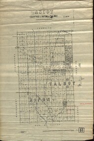
Plan - map, Ascot: Counties of Ripon and Talbot, 18/12/1920
... parish...Cadastral map showing parish boundaries and land ownership. "L5270"...Maps parishes located in Ascot area. Photo-Lithographed at the Dept. of Lands and Survey....Highlighted parish labelled, Mrs E.C.Sutherland....Highlighted parish labelled, Mrs E.C.Sutherland. Maps parishes located in Ascot area. ...Cadastral map showing parish boundaries and land ownership. "L5270"Maps parishes located in Ascot area. Photo-Lithographed at the Dept. of Lands and Survey.Highlighted parish labelled, Mrs E.C.Sutherland.parish, map, ascot, counties, e. c. sutherland, a. cameron, sweeney, w. j. clarke, mount hollowback, tourello, burrumbeet, glendaruel, dowling forest, a. j. mullett, w. j. butson, 1920, william coghill, chatham, chatham family collection, mrs e.c.sutherland. -
 Ringwood and District Historical Society
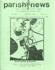
Newsletter, St Paul's Anglican Church Ringwood Victoria - Parish Newsletter Collection 1980s & 1990s (incomplete), 1983-1996
... St Paul's Anglican Church Ringwood Victoria - Parish Newsletter Collection 1980s & 1990s (incomplete)....Collection of Parish News monthly newsletter of St. Pail's Anglican Church, Ringwood...Approximately 100 Monthly Parish newsletters from St. Paul's Anglican Church, April 1983 then October 1986 to September 1996...Parish news...Ringwood and District Historical Society 125A Warrandyte Road Ringwood North melbourne Collection of Parish News monthly newsletter of St. Pail's Anglican Church, Ringwood Parish news Approximately 100 Monthly Parish newsletters from St. ...Collection of Parish News monthly newsletter of St. Pail's Anglican Church, RingwoodApproximately 100 Monthly Parish newsletters from St. Paul's Anglican Church, April 1983 then October 1986 to September 1996. (1986 - October & November only; 1987 - August only. Missing - July 1988, September 1992.) A4 bifold various coloured covers. Stapled.Parish news -
 Bendigo Historical Society Inc.
Map - CAMPBELL COLLECTION: BENDIGO AND DISTRICT MAPS
... ...parishes...Sandhurst and suburbs, Parish of Sandhurst, Parish of Huntly, Parish of Nerring, Parish of Marong, Parish of Lockwood, Parish of Wellsford, Parish of Strathfieldsaye, Parish of Mandurang...MAP Bendigo parishes Map. Sandhurst and suburbs, Parish of Sandhurst, Parish of Huntly, Parish of Nerring, Parish of Marong, Parish of Lockwood, Parish of Wellsford, Parish of Strathfieldsaye, Parish of Mandurang Map CAMPBELL COLLECTION: BENDIGO AND DISTRICT MAPS. ...Map. Sandhurst and suburbs, Parish of Sandhurst, Parish of Huntly, Parish of Nerring, Parish of Marong, Parish of Lockwood, Parish of Wellsford, Parish of Strathfieldsaye, Parish of Mandurangmap, bendigo, parishes -
 Bendigo Historical Society Inc.
Map - CAMPBELL COLLECTION: BENDIGO AND DISTRICT MAPS
... ...parishes...Map. Parish of Sandhurst, Parish of Huntly, Parish of Nerring, Parish of Marong, Parish of Lockwood, Parish of Wellsford, Parish of Strathfieldsaye, Parish of Mandurang. ...MAP Bendigo parishes Map. Parish of Sandhurst, Parish of Huntly, Parish of Nerring, Parish of Marong, Parish of Lockwood, Parish of Wellsford, Parish of Strathfieldsaye, Parish of Mandurang. ...Map. Parish of Sandhurst, Parish of Huntly, Parish of Nerring, Parish of Marong, Parish of Lockwood, Parish of Wellsford, Parish of Strathfieldsaye, Parish of Mandurang. Scale approx 1:18,000.map, bendigo, parishes -
 Ballan Shire Historical Society
Map - Map. Moorarbool East and West, Country Lands in the Parishes of Moorarbool East and Moorarbool West. Counties of Bourke and Grant
... Country Lands in the Parishes of Moorarbool East and Moorarbool West. ...Country Lands in the Parishes of Moorarbool East and Moorarbool West. ...This is a map of "Country Lands" around the Werribee River, north of Ballan in the Counties of Bourke and Grant.A relatively small map, paper on a material backing. Shows topographical features, roads and property divisions. Scale of forty chains to one inch. The map is dated March 31st, 1859.There is a small inscription under the chain scale that reads "No 58/364 John Phillips ? Survey 1st August 1858". The name Dugald McPherson is hand written on one of the blocks of land.moorarbool west, moorarbool east, dugald mcpherson, county of bourke, county of grant, werribee river, ballan -
 Ringwood and District Historical Society
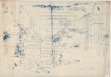
Map - Plan of Survey, Country Lands, Parishes of Warrandyte, Mooroolbark, Ringwood and Scoresby, Counties of Evelyn and Mornington - circa 1855
... Country Lands, Parishes of Warrandyte, Mooroolbark, Ringwood and Scoresby, Counties of Evelyn and Mornington - circa 1855....Clipped section of larger survey map including descriptions of treed areas and topographical features. Country Lands, Parishes of Warrandyte, Mooroolbark, Ringwood and Scoresby, Counties of Evelyn and Mornington - circa 1855. ...Clipped section of larger survey map including descriptions of treed areas and topographical features. Surveyed by (signature of J. Hardy) - Assistant Surveyor. -
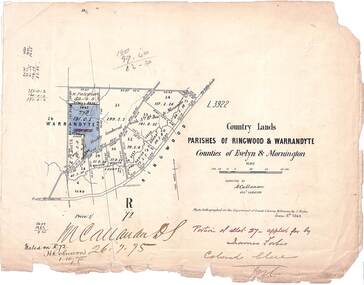 Ringwood and District Historical Society
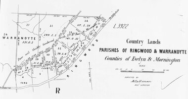
Map, Country Lands, Parishes of Ringwood & Warrandyte, Counties of Evelyn and Mornington - 1868
... Country Lands, Parishes of Ringwood & Warrandyte, Counties of Evelyn and Mornington - 1868....Torn edges. Country Lands, Parishes of Ringwood & Warrandyte, Counties of Evelyn and Mornington - 1868. ...Blue shaded area marked on Department of Lands & Survey map highlighting portion of allotment 27B applied for by James Forbes. Torn edges.L3922. Photo-lighographed at DL&S, Melbourne by J. Noone, June 8th, 1868. Signature of Assistant Surveyor M. Callanan dated 26.7.1875. Noted on R72 by H. Robinson, 1.10.1875. -
 Ringwood and District Historical Society
Map, Road Plan 108 - Gipps-land Road, Parishes of Bulleen and Warrandyte (Ringwood, Victoria) - 1855
... Road Plan 108 - Gipps-land Road, Parishes of Bulleen and Warrandyte (Ringwood, Victoria) - 1855...Road Plan 108 - Gipps-land Road, Parishes of Bulleen and Warrandyte (Ringwood, Victoria) - 1855 Map ...Surveyor's map of the part of the main road from Melbourne to Gippsland following "Barker's Track" south of Mullum Mullum or Deep Creek. Map references include Roman numerals marking distances measured in Links between trees at turns in the road.Submitted to the Surveyor General (Signed) July 2nd 1855. -
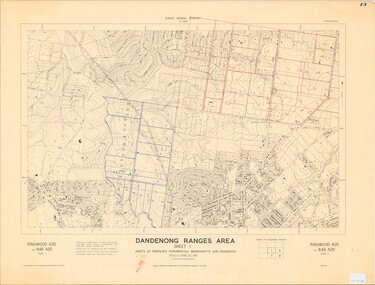 Ringwood and District Historical Society
Map - State Aerial Survey, Dandenong Ranges Area, Parts of Parishes of Nunawading, Warrandyte and Ringwood - 1956
... Dandenong Ranges Area, Parts of Parishes of Nunawading, Warrandyte and Ringwood - 1956....Dandenong Ranges Area, Parts of Parishes of Nunawading, Warrandyte and Ringwood - 1956. ...Map of Ringwood North and parts of Mitcham, Donvale, Park Orchards and Ringwood East compiled by Dept of Lands and Survey, July 1956, from aerial photographs and Cadastral Survey information. Sheet 1, Ringwood A2D or 849 A2D Zone 7. Scale: 4 chains to 1 inch. Contour interval 20 feet. -
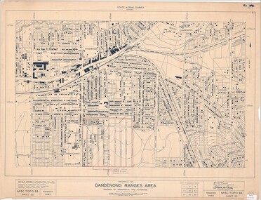 Ringwood and District Historical Society
Map - State Aerial Survey, Dandenong Ranges Area, Parishes of Warrandyte and Ringwood - 1956
... Dandenong Ranges Area, Parishes of Warrandyte and Ringwood - 1956....Dandenong Ranges Area, Parishes of Warrandyte and Ringwood - 1956. Map State Aerial Survey ...Map of central and southern areas of Ringwood and part of Ringwood East and Heathmont compiled by Dept of Lands and Survey, July 1956, from aerial photographs and Cadastral Survey information. Subsequent hand-drawn addition of streets showing layout of "Township of Ballyduffy Estate 1858-60", an earlier proposed subdivision that did not eventuate. (See attached 5009b Ballyshanassy_ Melbourne’s lost suburb.pdf for Ballyduffy historical naming relevance). Ballyduffy Estate streets include City Road, West Prussia Road, Duffy Street, Ireland Street, Evans Street, Victoria Street, Regina Street, Short Road, Prussia Road, Duffy Street East, Ireland Street East, Evans Street East, Chapman Street. Misc Topo 93 Sheet 22, Ringwood A4B2. Scale: 4 chains to 1 inch. Contour interval 20 feet. -
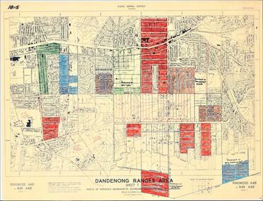 Ringwood and District Historical Society
Map - State Aerial Survey, Dandenong Ranges Area Sheet 7, Parishes of Warrandyte, Scoresby, Ringwood and Nunawading - 1956
... Dandenong Ranges Area Sheet 7, Parishes of Warrandyte, Scoresby, Ringwood and Nunawading - 1956....Dandenong Ranges Area Sheet 7, Parishes of Warrandyte, Scoresby, Ringwood and Nunawading - 1956. ...Map of central and southern areas of Ringwood and part of Ringwood East and Heathmont compiled by Dept of Lands and Survey, July 1956, from aerial photographs and Cadastral Survey information. Subsequent coloured hand-drawn additions showing layout of a number of post-NSW Separation era proposed subdivisions that did not eventuate, including Village of Studley Estate, Township of East Kew Estate, Township of Ballyduffy Estate, Township of New Flemington Estate, Township of East Hawthorne Estate. Ringwood A4B2, 849 A4B Zone 7. Scale: 10 chains to 1 inch. Contour interval 20 feet. -
 Federation University Historical Collection
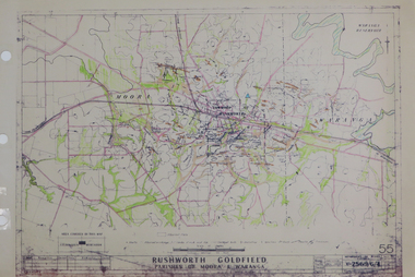
Plan, Rushworth Goldfield: Parishes of Moora and Waranga, pre 1954
... Rushworth Goldfield: Parishes of Moora and Waranga...Barker Library (top floor) Mount Helen goldfields rushworth moora waranga Printed plan on paper with hand colouring Rushworth Goldfield: Parishes of Moora and Waranga Plan Plan Department of Mines - Victoria ...Printed plan on paper with hand colouringrushworth, moora, waranga -
Stawell Historical Society Inc
Map, Department of Lands and Survey, Borough of Stawell. Parishes of Stawell and Illawarra 1903, 1903
... Borough of Stawell. Parishes of Stawell and Illawarra 1903...Plus one Printed on Paper Borough of Stawell. Parishes of Stawell and Illawarra 1903 Map Department of Lands and Survey ...Victoria Co., St Georges Co., Wimerra Co., Leviathon Co. Tramway, Quarry reserve, Newington Co., Galatea Co., Moonlight Co., Federal Co., Borough reservior., A0 Map of Stawell on linen backing. Plus one Printed on PaperPhoto Lithograped at the Department of Lands and survey Melbourne by T.F. McGauran 13.6.03surevy -
 Victorian Aboriginal Corporation for Languages
Book, An alphabetical list of loose bags, parishes, shires, stations, butter factories, hamlets, state schools, streets, village settlements, and places not being post towns in the colony of Victoria
... An alphabetical list of loose bags, parishes, shires, stations, butter factories, hamlets, state schools, streets, village settlements, and places not being post towns in the colony of Victoria...An alphabetical list of loose bags, parishes, shires, stations, butter factories, hamlets, state schools, streets, village settlements, and places not being post towns in the colony of Victoria Book Postal Department Victoria ...Photocopy of the original document of c. 1895-1897 listing all places not a Post Town in Victoria.listing of place and street namesvictorian geographical names, street names -
 Federation University Historical Collection
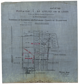
Plan, Plan applied for a Lease, Parishes of Glenmora and Rothcar, 27/05/1913
... Plan applied for a Lease, Parishes of Glenmora and Rothcar...Scale: 20 chains to in inch (1:15840) WGS 84 Centroid Lat: 37 degrees 01 feet 35 inches S Long: 143 degrees 30 feet 35 inches S NS: 3.2km EW: 2.8km Plan applied for a Lease, Parishes of Glenmora and Rothcar Plan Clarence Smith ...Plan on linen showing mining leases around the township of Lower Homebush, District of Maryborough. Scale: 20 chains to in inch (1:15840) WGS 84 Centroid Lat: 37 degrees 01 feet 35 inches S Long: 143 degrees 30 feet 35 inches S NS: 3.2km EW: 2.8km glenmona, rathcar, gladstone, maryborough, mining, clarence smith, homebush, clarence smith, w d thompson, peter leyden, b elliot, c horne, a field, john leydon, g jolly, r e jolly, d garner, s j barry, m harris, a harris, w j mcconnell, ellen harris, r j harris, j barry, t curtain, s garner, e barry, m j barry, l e squires, wilkins jnr, e c grace, e j field, mary field, m broughton, b l lusby, m j lusby, j e field, f broughton, j gillock, m simmons, glenmona, rathscar, parish of avoca, maryborough district, albert field, g grose, j harris -
 Bendigo Historical Society Inc.
Map - CAMPBELL COLLECTION: BENDIGO AND DISTRICT MAPS
... ...parishes...Eastern area of Bendigo, Parish of Huntly, Ascot, Shire of Huntly, Jackass Flat, Old White Hills, White Hills, Emu Point, North Bendigo, East Bendigo, Strathdale, Parish of Strathfieldsaye, Parish of Sandhurst, Parish of Wellsford....MAP Bendigo parishes Map. Eastern area of Bendigo, Parish of Huntly, Ascot, Shire of Huntly, Jackass Flat, Old White Hills, White Hills, Emu Point, North Bendigo, East Bendigo, Strathdale, Parish of Strathfieldsaye, Parish of Sandhurst, Parish of Wellsford. ...Map. Eastern area of Bendigo, Parish of Huntly, Ascot, Shire of Huntly, Jackass Flat, Old White Hills, White Hills, Emu Point, North Bendigo, East Bendigo, Strathdale, Parish of Strathfieldsaye, Parish of Sandhurst, Parish of Wellsford.map, bendigo, parishes -
 Bendigo Historical Society Inc.
Map - CAMPBELL COLLECTION: BENDIGO AND DISTRICT MAPS
... ...parishes...Map. Parishes and suburbs : North of Bendigo, Parish of Huntly, Parish of Nerring, Parish of Sandhurst, Sydney Flat, Myers Flat, Borough of Eaglehawk, Sailors Gully, Jobs Gully, Harvey Town, California Gully, Maiden Gully, Long Gully, St.Just's Point, Iron Bark....MAP Bendigo parishes Map. Parishes and suburbs : North of Bendigo, Parish of Huntly, Parish of Nerring, Parish of Sandhurst, Sydney Flat, Myers Flat, Borough of Eaglehawk, Sailors Gully, Jobs Gully, Harvey Town, California Gully, Maiden Gully, Long Gully, St.Just's Point, Iron Bark. ...Map. Parishes and suburbs : North of Bendigo, Parish of Huntly, Parish of Nerring, Parish of Sandhurst, Sydney Flat, Myers Flat, Borough of Eaglehawk, Sailors Gully, Jobs Gully, Harvey Town, California Gully, Maiden Gully, Long Gully, St.Just's Point, Iron Bark.map, bendigo, parishes -
 Sunshine and District Historical Society Incorporated
Map - Parish Of Cut Paw Paw County of Bourke Map, 30th October 1930
... Large map of the Parish Of Cut Paw Paw County...Parish Of Cut Paw Paw County of Bourke Map...Cut Paw Paw County of Bourke Map Parish Of Cut Paw Paw County of Bourke Map Large map of the Parish Of Cut Paw Paw County Map Parish Of Cut Paw Paw County of Bourke Map ...Parish Of Cut Paw Paw County of Bourke Mapcut paw paw county of bourke map -
 Bendigo Historical Society Inc.
Book - BENDIGO NORTH ANGLICAN PARISH
... 24 page soft cover booklet 'Bendigo North Anglican Parish' A brief history of the 3 churches from 1952 to 1992. ...Anglican Parish of North Bendogo...St John's, North Bendigo St Luke's, White Hills St Clement's, Huntly Sketches of churches on front cover. Lists of Parish Councillors Book BENDIGO NORTH ANGLICAN PARISH ...24 page soft cover booklet 'Bendigo North Anglican Parish' A brief history of the 3 churches from 1952 to 1992. St John's, North Bendigo St Luke's, White Hills St Clement's, Huntly Sketches of churches on front cover. Lists of Parish CouncillorsAnglican Parish of North Bendogo -
 Bendigo Historical Society Inc.
Map - CAMPBELL COLLECTION: BENDIGO AND DISTRICT MAPS
... ...parishes...South and West of Bendigo, Parish of Marong, Moonta, West Bendigo, Specimen Hill, Golden Square, Shire of Marong, Golden Gully, Kangaroo Flat, Diamond Hill, Shire of Strathfieldsaye, Crusoe, Parish of Lockwood....MAP Bendigo parishes Map. South and West of Bendigo, Parish of Marong, Moonta, West Bendigo, Specimen Hill, Golden Square, Shire of Marong, Golden Gully, Kangaroo Flat, Diamond Hill, Shire of Strathfieldsaye, Crusoe, Parish of Lockwood. ...Map. South and West of Bendigo, Parish of Marong, Moonta, West Bendigo, Specimen Hill, Golden Square, Shire of Marong, Golden Gully, Kangaroo Flat, Diamond Hill, Shire of Strathfieldsaye, Crusoe, Parish of Lockwood.map, bendigo, parishes -
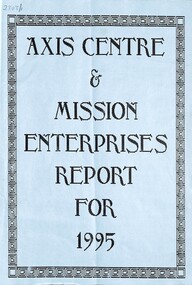 Sunshine and District Historical Society Incorporated
Document - Sunshine Uniting Church Parish
... Collection of documents of the Sunshine Uniting Church Parish...2303.01 - Sunshine Uniting Church Parish - Axis Centre & Mission Enterprises Report For 1995...Sunshine Uniting Church Church Withers Street Sunshine 2303.01 - Sunshine Uniting Church Parish - Axis Centre & Mission Enterprises Report For 1995 Collection of documents of the Sunshine Uniting Church Parish Document Sunshine Uniting Church Parish ...2303.01 - Sunshine Uniting Church Parish - Axis Centre & Mission Enterprises Report For 1995sunshine uniting church, church, withers street, sunshine -
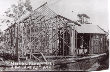 Lakes Entrance Historical Society
Photograph - Metung Hall 1920
... Black and white photograph of the Metung Parish Hall under construction. Metung Victoria...Metung Parish Hall 5pm August 14 1920, Working Bee...Religion Halls Metung Parish Hall 5pm August 14 1920, Working Bee Black and white photograph of the Metung Parish Hall under construction. ...Building of Hall commenced 1920.Black and white photograph of the Metung Parish Hall under construction. Metung VictoriaMetung Parish Hall 5pm August 14 1920, Working Beereligion, halls