Showing 36 items matching "plane table"
-
 Bendigo Military Museum
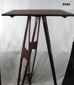
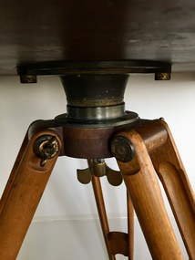
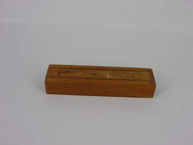
Instrument - Survey Plane Table with Tripod, Circa 1910
... Survey Plane Table with Tripod...Survey Plane Table with Tripod...A Plane Table consists of a smooth wooden table surface (with metal strengthening supports) mounted on a sturdy base. ...A wooden Plane Table with alloy fittings to strengthen and support the table top. ...The table is fixed to a three-legged wooden Tripod with cast alloy fittings and metal pointed tips. Survey Plane Table with Tripod Instrument Survey Plane Table with Tripod ...A Plane Table consists of a smooth wooden table surface (with metal strengthening supports) mounted on a sturdy base. The base, a three-legged Tripod, is designed to support the table over a specific point on land. The connection between the tabletop and the adjustable Tripod legs permits the user to level the table precisely, using bubble levels in a horizontal plane regardless of the roughness of the terrain. The Plane Table is a surveying device used in surveying and mapping to provide a level surface on which to make drawings, charts or maps. An alidade, with or without a telescope located on the tabletop is used to sight features and draw angles to that feature. Using these lines to the same feature from different setup locations it is possible to locate that feature on the map. Plane Tabeling was widely used by the early members of the Australian Survey Corps and in both World Wars. It remains a simple and effective tool to teach the fundamentals of mapping and surveying. It was simple to use and was reasonably robust and portable. See also item 6489.2 for the Plane Table Alidade.A wooden Plane Table with alloy fittings to strengthen and support the table top. The table is fixed to a three-legged wooden Tripod with cast alloy fittings and metal pointed tips.royal australian survey corps, rasvy, fortuna, army survey regiment, army svy regt, asr, 4 fd svy sqn, school of military survey -
 Bendigo Military Museum
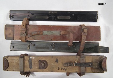
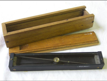
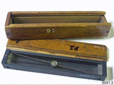
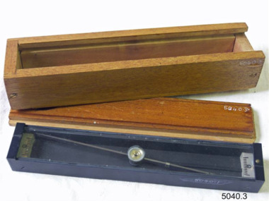
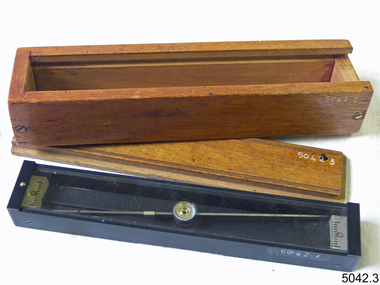
Instrument - Plane Table Surveying - Simple Alidade, ER Watts and Son, London, 1938
... Plane Table Surveying - Simple Alidade...Plane Table Surveying - Simple Alidade...The Plane Table Alidade was used as the sighting Instrument in the production of historical manual hand drawn maps. ...Two Plane Table sighting instruments (Alidade) used for historical manual map making housed in wooden transit boxes. ...A Plane Table Board mounted on a tripod is levelled and the Alidade is placed on the table with the vanes perpendicular to the it. ...The Plane Table Alidade was used as the sighting Instrument in the production of historical manual hand drawn maps. A Plane Table Board mounted on a tripod is levelled and the Alidade is placed on the table with the vanes perpendicular to the it. Each sighting vane has a central thread lined up on the target and the angle to that target point is then drawn on the map sheet using the beveled fiducial edge. Plane Table Surveying is used as a quick method where less accuracy is required or needed. Plane table Surveying is a relatively portable and inexpensive method and was used extensively before the advent of sophisticated surveying instruments. The photo at 6489.2 is an Australian Army Survey Corps Party using a Plane Table Alidade in Syria during WWII. See also item 6580 which is the Plane Table with tripod legs that was used with the Alidade.Two Plane Table sighting instruments (Alidade) used for historical manual map making housed in wooden transit boxes. A brass instrument with folding sights at each end and a beveled fiducial edge in one edge. The front sight is the object vane and the rear sight is the sight vane. There is a sliding arm attached to the base to draw parallel lines to the fiducial edge. Very slight differences in model between these two instruments.First Instrument, "ER Watts and Son, London, 1938, MkII, Box Label 423. Second Instrument - R. E-Co, Mk.II, stamped E686, Box Label 686.royal australian survey corps, rasvy, fortuna, army survey regiment, army svy regt, asr -
 Bendigo Military Museum
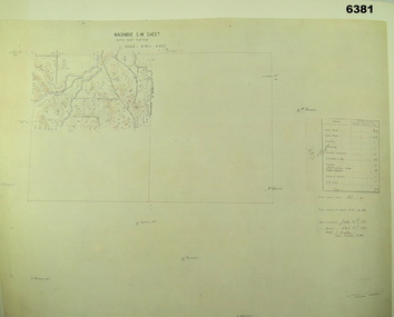
Map - Australian Topographical Survey NAGAMBIE SW Sheet, 1 inch:1 Mile, NW portion Plane Table Field sheet 1921, Australian Survey Corps, 1921
... Australian Topographical Survey NAGAMBIE SW Sheet, 1 inch:1 Mile, NW portion Plane Table Field sheet 1921...Australian Topographical Survey NAGAMBIE SW Sheet, 1 inch:1 Mile, NW portion Plane Table Field sheet 1921...The reverse side of this print is a copy of the Tallarook plane table South East field sheet....Reprinted coloured Image of Australian Topographical Survey NAGAMBIE SW Sheet,1 inch:1 Mile, NW portion hand drawn Plane Table Field sheet. Includes an itemized summary of work, signed by Sgt J Cullen Australian Survey Corps September1921....Australian Topographical Survey NAGAMBIE SW Sheet, 1 inch:1 Mile, NW portion Plane Table Field sheet 1921 Map Australian Topographical Survey NAGAMBIE SW Sheet, 1 inch:1 Mile, NW portion Plane Table Field sheet 1921 Australian Survey Corps ...This is a coloured reproduction print of an original Plane Table compilation map sheet of Nagambie area 1inch to 1 Mile scale compiled by Sgt Jack Cullen Australian Survey Corps 30 September 1921. Jack was one of the foundation members of the Australian Survey Corps. Of particular interest is the fact that this is a heighted compilation with contouring (required for Military use) as many early maps were purely planimetric. A table on the right hand side details the number of days that it took to produce the compilation. The reverse side of this print is a copy of the Tallarook plane table South East field sheet.Reprinted coloured Image of Australian Topographical Survey NAGAMBIE SW Sheet,1 inch:1 Mile, NW portion hand drawn Plane Table Field sheet. Includes an itemized summary of work, signed by Sgt J Cullen Australian Survey Corps September1921.royal australian survey corps, rasvy, fortuna, army survey regiment, army svy regt, asr -
 Bendigo Military Museum
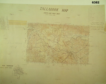
Map - Australian Topographical Survey TALLAROOK SE Sheet, 1 inch:1 Mile, NW portion Plane Table Field sheet 1923, Australian Survey Corps, 1923
... Australian Topographical Survey TALLAROOK SE Sheet, 1 inch:1 Mile, NW portion Plane Table Field sheet 1923...Australian Topographical Survey TALLAROOK SE Sheet, 1 inch:1 Mile, NW portion Plane Table Field sheet 1923...The reverse side of this print is a copy of the Nagambie plane table South West field sheet....Reprinted coloured Image of Australian Topographical Survey TALLAROOK SE field Sheet,1 inch:1 Mile, hand drawn contoured Plane Table Field sheet. Signed by Sgt J Cullen Australian Survey Corps November1923. ...Australian Topographical Survey TALLAROOK SE Sheet, 1 inch:1 Mile, NW portion Plane Table Field sheet 1923 Map Australian Topographical Survey TALLAROOK SE Sheet, 1 inch:1 Mile, NW portion Plane Table Field sheet 1923 Australian Survey Corps ...This is a coloured reproduction print of an original Plane Table compilation map sheet of Tallarook area 1inch to 1 Mile scale compiled by Sgt Jack Cullen Australian Survey Corps 12 November 1923 and signed by Capt J Lynch. Capt Lynch and Sgt Cullen were both foundation members of the Australian Survey Corps. Of particular interest is the fact that this is a heighted compilation with contouring (required for Military use) as many early maps were purely planimetric. The reverse side of this print is a copy of the Nagambie plane table South West field sheet.Reprinted coloured Image of Australian Topographical Survey TALLAROOK SE field Sheet,1 inch:1 Mile, hand drawn contoured Plane Table Field sheet. Signed by Sgt J Cullen Australian Survey Corps November1923. An enlargement of YEA Township 2 Inches to 1 Mile Scale.royal australian survey corps, rasvy, fortuna, army survey regiment, army svy regt, asr -
 Bendigo Military Museum
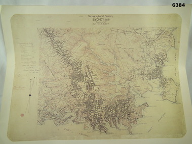
Map - Australian Topographical Survey SYDNEY / 56III Southern Half, NE Plane Table Field sheet 1915, Australian Survey Corps, 6 Dec 1915
... Australian Topographical Survey SYDNEY / 56III Southern Half, NE Plane Table Field sheet 1915...Australian Topographical Survey SYDNEY / 56III Southern Half, NE Plane Table Field sheet 1915...This is a unique example of a hand drawn plane table sheet produced in the first year of the Australian Survey Corps by original members of the Corps. ...Reprinted coloured Image of Australian Topographical Survey SYDNEY /56 III Southern Half, hand drawn NE Plane Table field sheet. Includes an itemized summary of work performed by HA Roseblade CSM Australian Survey Corps 1915, Signed by J Lynch Lieutenant....Australian Topographical Survey SYDNEY / 56III Southern Half, NE Plane Table Field sheet 1915 Map Australian Topographical Survey SYDNEY / 56III Southern Half, NE Plane Table Field sheet 1915 Australian Survey Corps ...This is a unique example of a hand drawn plane table sheet produced in the first year of the Australian Survey Corps by original members of the Corps. Roseblade and Lynch 5 Dec 1915. Of interest is the documented times that it took to create the original field sheet. Also of interest is the fact that this field sheet that was used to create the actual SYDNEY map sheet was contoured, many map sheets produced up until now were purely planimetric and lacked contouring that was needed for military use. This is a reproduction print of a photograph of the original field sheet and was printed at the Army Survey Regiment, Bendigo.Reprinted coloured Image of Australian Topographical Survey SYDNEY /56 III Southern Half, hand drawn NE Plane Table field sheet. Includes an itemized summary of work performed by HA Roseblade CSM Australian Survey Corps 1915, Signed by J Lynch Lieutenant.royal australian survey corps, rasvy, fortuna, army survey regiment, army svy regt, asr -
 Bendigo Military Museum
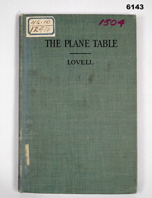
Manual - The Plane Table - Its Use in Surveying, McGraw Publishing Company, New York, USA, 1908
... The Plane Table - Its Use in Surveying...The Plane Table - Its Use in Surveying...The plane table instrument was a simple but very effective early method of producing maps. ...Bendigo Military Museum 37 - 39 Pall Mall Bendigo goldfields The plane table instrument was a simple but very effective early method of producing maps. ...The plane table instrument was a simple but very effective early method of producing maps. Some very early editions were produced by the Australian Survey Corps after its formation in 1915 using this method. This manual details how to use the "Plane Table" for Surveying purposes.Hard Cloth covered Covers front and back, paper pages. title page has rubber stamp impressions (see below). Contents page, symbols page, pages 1-47 and index page.Adhesive label on front "46.10 and 12411", "1504" in purple also on front cover, Numbers inside front cover - "Acc. No. 000076" and crossed out. "scm - B0 - 86-72" written underneath. stamps- Australian Intelligence Corps, Headquarters library No 150 (difficult to read) on first page and stamped "CANCELLED" , Stamp School of Military Survey Library Call No 526 - 9825 LOV. Another stamp on title page - Department of Defence Library 46.10 and 12411. Second stamp 2/D. M.O.S. 2012 with CANCELLED. royal australian survey corps, rasvy, army survey regiment, army svy regt, asr, fortuna -
 Federation University Historical Collection
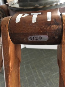
Instrument - Scientific Instrument, W.&L.E. Gurley, Plane Table
... Plane Table...plane table...A spherical mount on the underside, designed to match the receptacle on top of the tripod - Item 04129. Plane Table Instrument Scientific Instrument W. ...Used at the Ballarat School of Mines in Surveying classes. It was used in conjunction with Item 04129 - Collapsible leg surveying instrument, tripod, and at times with Item 4127 - Tripod location chains.A wooden platform used in surveying equipped with a 2.7 cm diameter dowel at each end that would hold the charts/papers in position. A spherical mount on the underside, designed to match the receptacle on top of the tripod - Item 04129.Manufacturer's stamp underneath.plane table, surveying, w. & l.e. gurley, scientific instrument, ballarat school of mines, tripod, location chains -
 Frankston RSL Sub Branch
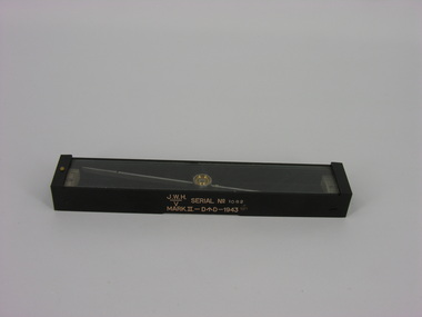
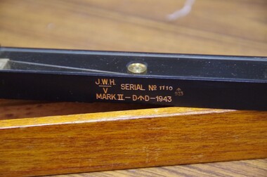
Compass, Plane Table, J. W. Handley, 1943
... Compass, Plane Table......plane table compass...A plane table compass, sometimes referred to as a trough compass, used by surveyors and artillery crew to accurately establish magnetic north. ...Refer 00330 and 00330.2 Compass, Plane Table J. W. Handley ...A plane table compass, sometimes referred to as a trough compass, used by surveyors and artillery crew to accurately establish magnetic north. The compass is precision machined of brass material with a long needle to ensure accuracy. The compass scale is marked with a centre zero (for magnetic north) and graduations indicating plus and minus five degrees. The compass is housed in a protective wooden case with a sliding lid. The lid has a brass slide which locks the compass needle during periods when the compass is not in use. This compass is the type used by an artillery unit of the Australian Military Forces during World War 2. This compass was manufactured by J. W. Handley P/L of Melbourne in 1943. Refer 00330 and 00330.2The side of the compass body is stamped: "J.W.H." with the letter "V" under a line, "SERIAL No 1082", MARK.II-D^D-1943". The case is stamped with the serial number "1082".artillery, trough compass, plane table compass, compass, world war 2, ww2 -
 Frankston RSL Sub Branch
Compass, Plane Table
... Compass, Plane Table...A plane table compass as used by surveyors and artillery crew complete with a protective wooden transit case. ...Refer 00330.1 and 00330.2 Compass, Plane Table ...A plane table compass as used by surveyors and artillery crew complete with a protective wooden transit case. This compass is the type used by artillery units of the Australian Military Forces during World War 2. This compass was manufactured by J. W. Handley P/L of Melbourne in 1943. Refer 00330.1 and 00330.2 -
 Federation University Historical Collection
Instrument - Scientific Instruments, W.& L.E. Gurley, Collapsible Leg Surveying Instrument: Tripod
... ...plane table...Used with the Plane Table - Item 4130, in surveying classes at Ballarat School of Mines. ...Barker Library (top floor) Mount Helen goldfields Used with the Plane Table - Item 4130, in surveying classes at Ballarat School of Mines. ...Used with the Plane Table - Item 4130, in surveying classes at Ballarat School of Mines. Item 4127, Tripod Location Chains, may also have been used.A large tripod of timber construction. Concave top mount flange to receive matching spherical spigot. Spacer block halfway up each twin-strut leg.In white paint on the top "PTI" Manufacturer's stamp on each leg - circular. "W.& L.E. GURLEYtripod, surveying, scientific instrument, ballarat school of mines, plane table, location chains, w & l e gurley -
 Federation University Historical Collection
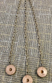
Instrument - Scientific Instruments, Tripod Location Chains
... ...plane table...Could also be used with item 4130 - Plane Table which goes with the tripod mentioned....Could also be used with item 4130 - Plane Table which goes with the tripod mentioned. surveying metal steel discs scientific instruments location chains plane table A set of three steel discs, connected in star configuration by three brass chains of equal length. ...Surveying instrument accessories. Two sets. Used in conjunction with item 4129 - Collapsible leg surveying instrument, tripod. Could also be used with item 4130 - Plane Table which goes with the tripod mentioned.A set of three steel discs, connected in star configuration by three brass chains of equal length. Used to contain tripod ends on hard smooth surfaces.surveying, metal, steel discs, scientific instruments, location chains, plane table -
 Running Rabbits Military Museum operated by the Upwey Belgrave RSL Sub Branch
Compass
... Plane Table Narrow Compass. Used by Artillery Units for Mapping. ...Running Rabbits Military Museum operated by the Upwey Belgrave RSL Sub Branch 1 Mast Gully Road Upwey melbourne Ephemera WW2 Army Plane Table Narrow Compass. Used by Artillery Units for Mapping. ...Plane Table Narrow Compass. Used by Artillery Units for Mapping. Made by AW Handleyephemera, ww2, army -
 Frankston RSL Sub Branch
Case, Transit
... A wooden, protective transit case to suit a plane table compass as used by surveyors and artillery crew. ...Frankston RSL Sub Branch 183 Cranbourne Road Frankston mornington-peninsula A wooden, protective transit case to suit a plane table compass as used by surveyors and artillery crew. ...A wooden, protective transit case to suit a plane table compass as used by surveyors and artillery crew. These compasses were used by artillery units of the Australian Military Forces during World War 2. Refer 00330 and 00330.1 -
 Flagstaff Hill Maritime Museum and Village
Plane Compass, 1941-1943
... A plane table compass, sometimes referred to as a trough compass, used by surveyors and artillery crew to accurately establish magnetic north. ...Serial No 353 A plane table compass, sometimes referred to as a trough compass, used by surveyors and artillery crew to accurately establish magnetic north. ...This compass is the type used by an artillery unit of the Australian Military Forces during World War 2 and made by J W Handley. Although having owned the factory site since 1935 at 657 Victoria St J W Handley began to produce various items for the Australian Military forces after purchasing and expanding the factory to 655 Victoria St. It appears that he, or some one else may already have been occupying the site for industrial purposes, such as (Manufacturing, Foundry and Electroplating) since at least 1929. J W Handley Pty Ltd was actively producing items for the Military during the war years, a newspaper article from 1939 shows the factory in production and employing 420 people during 1939. J W Handley after the war moved into producing other non military items including a range of fishing reels. The company ceased trading in 1987 and was deregistered as J W Handley Pty Ltd in 1990.The item demonstrates the industrial capability of Australia at the start of World War 2. This item is actively sort by collectors of Australian Military memorabilia and represents a time in Australian history when the country was at war and the general population was concerned about an invasion from Japanese forces. It also therefor is of social significance as many Australians served in the Military forces at that time and the item is complete and in very good condition.A plane table compass, sometimes referred to as a trough compass, used by surveyors and artillery crew to accurately establish magnetic north. The compass is precision machined of brass material with a long needle to ensure accuracy. The compass scale is marked with a centre zero (for magnetic north) and graduations indicating plus and minus five degrees. The compass is housed in a protective wooden case with a sliding lid. The lid has a brass slide which locks the compass needle during periods when the compass is not in use.J.W.H./V Mark 11 D↑D. Made by J W Handley Richmond Melbourne, Victoria. Serial No 353flagstaff hill, warrnambool, shipwrecked-coast, flagstaff-hill, flagstaff-hill-maritime-museum, maritime-museum, shipwreck-coast, flagstaff-hill-maritime-village, trough compass, navigation instrument, surveyor's instrument, j w handley, artillery, australian army, trough, plane compass, world war 2 -
 Flagstaff Hill Maritime Museum and Village
Plane Compass, 1941-1943
... A plane table compass, sometimes referred to as a trough compass, used by surveyors and artillery crew to accurately establish magnetic north. ...Serial number 92 A plane table compass, sometimes referred to as a trough compass, used by surveyors and artillery crew to accurately establish magnetic north. ...This compass is the type used by an artillery unit of the Australian Military Forces during World War 2 and made by J W Handley. Although having owned the factory site since 1935 at 657 Victoria St J W Handley began to produce various items for the Australian Military forces after purchasing and expanding the factory to 655 Victoria St. It appears that he, or some one else may already have been occupying the site for industrial purposes, such as (Manufacturing, Foundry and Electroplating) since at least 1929. J W Handley Pty Ltd was actively producing items for the Military during the war years, a newspaper article from 1939 shows the factory in production and employing 420 people during 1939. J W Handley after the war moved into producing other non military items including a range of fishing reels. The company ceased trading in 1987 and was deregistered as J W Handley Pty Ltd in 1990.The item demonstrates the industrial capability of Australia at the start of World War 2. This item is actively sort by collectors of Australian Military memorabilia and represents a time in Australian history when the country was at war and the general population was concerned about an invasion from Japanese forces. It also therefor is of social significance as many Australians served in the Military forces at that time and the item is complete and in very good condition.A plane table compass, sometimes referred to as a trough compass, used by surveyors and artillery crew to accurately establish magnetic north. The compass is precision machined of brass material with a long needle to ensure accuracy. The compass scale is marked with a centre zero (for magnetic north) and graduations indicating plus and minus five degrees. The compass is housed in a protective wooden case with a sliding lid. The lid has a brass slide which locks the compass needle during periods when the compass is not in use.J.W.H./V Mark 11 D↑D. Made by J W Handley Richmond Melbourne, Victoria. Serial number 92 flagstaff hill, warrnambool, shipwrecked-coast, flagstaff-hill, flagstaff-hill-maritime-museum, maritime-museum, shipwreck-coast, flagstaff-hill-maritime-village, trough compass, navigation instrument, surveyor's instrument, j w handley, artillery, australian army, trough, plane compass, world war 2 -
 Flagstaff Hill Maritime Museum and Village
Plane Compass, 1941-1943
... A plane table compass, sometimes referred to as a trough compass, used by surveyors and artillery crew to accurately establish magnetic north. ...Serial number 1279 A plane table compass, sometimes referred to as a trough compass, used by surveyors and artillery crew to accurately establish magnetic north. ...This compass is the type used by an artillery unit of the Australian Military Forces during World War 2 and made by J W Handley. Although having owned the factory site since 1935 at 657 Victoria St J W Handley began to produce various items for the Australian Military forces after purchasing and expanding the factory to 655 Victoria St. It appears that he, or some one else may already have been occupying the site for industrial purposes, such as (Manufacturing, Foundry and Electroplating) since at least 1929. J W Handley Pty Ltd was actively producing items for the Military during the war years, a newspaper article from 1939 shows the factory in production and employing 420 people during 1939. J W Handley after the war moved into producing other non military items including a range of fishing reels. The company ceased trading in 1987 and was deregistered as J W Handley Pty Ltd in 1990.The item demonstrates the industrial capability of Australia at the start of World War 2. This item is actively sort by collectors of Australian Military memorabilia and represents a time in Australian history when the country was at war and the general population was concerned about an invasion from Japanese forces. It also therefor is of social significance as many Australians served in the Military forces at that time and the item is complete and in very good condition.A plane table compass, sometimes referred to as a trough compass, used by surveyors and artillery crew to accurately establish magnetic north. The compass is precision machined of brass material with a long needle to ensure accuracy. The compass scale is marked with a centre zero (for magnetic north) and graduations indicating plus and minus five degrees. The compass is housed in a protective wooden case with a sliding lid. The lid has a brass slide which locks the compass needle during periods when the compass is not in use.J.W.H./V Mark 11 D↑D. Made by J W Handley Richmond Melbourne, Victoria. Serial number 1279flagstaff hill, warrnambool, shipwrecked-coast, flagstaff-hill, flagstaff-hill-maritime-museum, maritime-museum, shipwreck-coast, flagstaff-hill-maritime-village, trough compass, navigation instrument, surveyor's instrument, j w handley, artillery, australian army, trough, plane compass, world war 2 -
 Flagstaff Hill Maritime Museum and Village
Plane Compass, 1941-1943
... A plane table compass, sometimes referred to as a trough compass, used by surveyors and artillery crew to accurately establish magnetic north. ...Serial number 1333 on box A plane table compass, sometimes referred to as a trough compass, used by surveyors and artillery crew to accurately establish magnetic north. ...This compass is the type used by an artillery unit of the Australian Military Forces during World War 2 and made by J W Handley. Although having owned the factory site since 1935 at 657 Victoria St J W Handley began to produce various items for the Australian Military forces after purchasing and expanding the factory to 655 Victoria St. It appears that he, or some one else may already have been occupying the site for industrial purposes, such as (Manufacturing, Foundry and Electroplating) since at least 1929. J W Handley Pty Ltd was actively producing items for the Military during the war years, a newspaper article from 1939 shows the factory in production and employing 420 people during 1939. J W Handley after the war moved into producing other non military items including a range of fishing reels. The company ceased trading in 1987 and was deregistered as J W Handley Pty Ltd in 1990.The item demonstrates the industrial capability of Australia at the start of World War 2, this item is actively sort by collectors of Australian Military memorabilia and represents a time in Australian history when the country was at war and the general population was concerned about an invasion from Japanese forces. It also therefor is of social significance as many Australians served in the Military forces at that time and the item is complete and in very good condition.A plane table compass, sometimes referred to as a trough compass, used by surveyors and artillery crew to accurately establish magnetic north. The compass is precision machined of brass material with a long needle to ensure accuracy. The compass scale is marked with a centre zero (for magnetic north) and graduations indicating plus and minus five degrees. The compass is housed in a protective wooden case with a sliding lid. The lid has a brass slide which locks the compass needle during periods when the compass is not in use.J.W.H./V Mark 11 D�D. Made by J W Handley Richmond Melbourne, Victoria. Serial number 1333 on boxflagstaff hill, warrnambool, shipwrecked-coast, flagstaff-hill, flagstaff-hill-maritime-museum, maritime-museum, shipwreck-coast, flagstaff-hill-maritime-village, trough compass, navigation instrument, surveyor's instrument, j w handley, artillery, australian army, trough, plane compass, world war 2 -
 Bendigo Military Museum
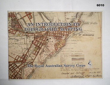
Pamphlet - An Introduction to Topographic Mapping, C 1991
... Printed on the pamphlet cover was a portion of the plane tabled “four inches to a mile” map of Newcastle. ...Printed on the pamphlet cover was a portion of the plane tabled “four inches to a mile” map of Newcastle. ...This pamphlet was published by the Army Survey Regiment as an overview of the Royal Australian Survey Corps (RASvy), its role and unit structure circa 1991, prior to RASvy’s disbandment in 1996. The pamphlet comprehensively detailed the eight steps of topographic map production: Establish Survey Control, Aerial Photography, Aerotriangulation, Stereoplotting, Field Verification, Cartography, Printing and Storage/Map Distribution. Leading technologies used by RA Svy in 1991 included GPS control surveys, 5 colour printing on the Speedmaster offset press and bulk map packaging using the Map Handling Station (with guillotine). Digital map production was operating on the AUTOMAP 2 system, before the “Newheart” system upgrade two years later. Printed on the pamphlet cover was a portion of the plane tabled “four inches to a mile” map of Newcastle. This was compiled and surveyed in 1910 by LCPL A. Barrett, a member of the RAE Detachment, as part of the first major topographic mapping effort of Australia.This is a Royal Australian Survey Corp pamphlet with a historical map printed in colour on cardboard on both sides of the cover. There are 16 pages printed in colour on gloss paper, with photos, diagrams and descriptions. The pamphlet is bounded by two staples on its spine. Each of the 17 images were scanned at 300 dpi in JPEG (.jpg) format and stored on the attached 16 Gb USB memory stick. The images have been converted into MPEG-4 (.mp4) video format, 4Mb in size and runs for 2:16 minutes and is also stored on the memory stick.royal australian survey corps, rasvy, fortuna, army survey regiment, army svy regt, asr -
 Bendigo Military Museum
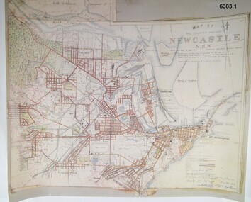
Map - Map of Newcastle NSW 4 Inch - 1 Mile 1910, Australian Intelligence Corps, Nov 1910
... They were aiming at producing eight map sheets per year covering about 7,000 square miles (18,000 square Km) This map sheet of the Newcastle area was produced using plane table methods and was surveyed and hand drawn by LCPL A Barrett Oct - Nov 2010. ...They were aiming at producing eight map sheets per year covering about 7,000 square miles (18,000 square Km) This map sheet of the Newcastle area was produced using plane table methods and was surveyed and hand drawn by LCPL A Barrett Oct - Nov 2010. ...In 1909 the Australian Army Headquarters realized that mapping in Australia was either non existent or inadequate for Military use. It was requested that Australia borrow Survey personnel from the UK Royal Engineers (RE) for a two-year detachment. On 11 April 1910 four RE NCOs arrived in Melbourne comprising CPL J Lynch, and LCPLs AH Barrett, EF Davies and R Wilcox. LCPL Barrett had 12yrs experience with RE. They were aiming at producing eight map sheets per year covering about 7,000 square miles (18,000 square Km) This map sheet of the Newcastle area was produced using plane table methods and was surveyed and hand drawn by LCPL A Barrett Oct - Nov 2010. It was unique because it was now produced on an accurate gridded base and included contouring. Lynch and Davies transferred to the Royal Australian Engineers (RAE) whilst Barrett and Wilcox returned to the UK in June 1913. Barrett returned to Australia in 1915 and also enlisted in the RAE and served until 1919.A gridded Map of Newcastle NSW area scale four inches to one mile with 25 feet interval contouring. Coloured hand drawn map produced in 1910. Signed by " A Barrett LCPL Royal Engineers"royal australian survey corps, rasvy, fortuna, army svy regt, army survey regiment -
 Bendigo Military Museum
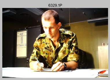
Photograph - Tasks Demonstrated by Royal Australian Survey Corps Technicians, c1990s
... The photos are part of the Army Survey Regiment’s Collection. .1) – Photo, colour, c1992, Aerial photography Assessment, SGT Tony Grivell. .2) – Photo, colour, c1992, Aerial photography Assessment, L to R: WO2 Noel McNamara and LCPL Grant Lloyd. .3) – Photo, colour, c1992, Wild PUG4 point transfer device, LCPL Mark Fedden. .4) – Photo, colour, c1992, AUTOMAP 2 Graphic Edit Workstation, unidentified technician. .5) – Photo, colour, c1992, Heidelberg Speedmaster 102 computer-controlled five colour lithographic offset printing press, CPL Nick Vanderzwan. .6) – Photo, colour, c1992, Daylight film contact frame, SPR Ken Labourchardiere. .7) – Photo, colour, c1992, Heidelberg Speedmaster 102 Map Colour Evaluation Workstation, SGT Stuart Ridge. .8) – Photo, colour, c1992, Map proof evaluation, CPL John Bragg. .9) – Photo, colour, c1992, Wohlenberg MCS-2 guillotine, unidentified technician. .10) – Photo, colour, c1992, Wild T2 Theodolite, L to R: SPR Matt Arnold, SPR Kim Baker. .11) – Photo, colour, c1992, Wild T2 Theodolite, L to R: SSGT Bob Bright, SPR Kim Baker. .12) to .14) – Photo, colour, c1992, MRA-7 Tellurometer, CPL Mark Bourne. .15) – Photo, colour, c1992, Plane Tabling, CPL Mark Bourne. .16) – Photo, colour, c1992, School of Military Survey base camp, Sandy Creek, VIC. .17) – Photo, black & white, 1990, MRA-7 Tellurometer, CPL Steve Nokes. ...The photos are part of the Army Survey Regiment’s Collection. .1) – Photo, colour, c1992, Aerial photography Assessment, SGT Tony Grivell. .2) – Photo, colour, c1992, Aerial photography Assessment, L to R: WO2 Noel McNamara and LCPL Grant Lloyd. .3) – Photo, colour, c1992, Wild PUG4 point transfer device, LCPL Mark Fedden. .4) – Photo, colour, c1992, AUTOMAP 2 Graphic Edit Workstation, unidentified technician. .5) – Photo, colour, c1992, Heidelberg Speedmaster 102 computer-controlled five colour lithographic offset printing press, CPL Nick Vanderzwan. .6) – Photo, colour, c1992, Daylight film contact frame, SPR Ken Labourchardiere. .7) – Photo, colour, c1992, Heidelberg Speedmaster 102 Map Colour Evaluation Workstation, SGT Stuart Ridge. .8) – Photo, colour, c1992, Map proof evaluation, CPL John Bragg. .9) – Photo, colour, c1992, Wohlenberg MCS-2 guillotine, unidentified technician. .10) – Photo, colour, c1992, Wild T2 Theodolite, L to R: SPR Matt Arnold, SPR Kim Baker. .11) – Photo, colour, c1992, Wild T2 Theodolite, L to R: SSGT Bob Bright, SPR Kim Baker. .12) to .14) – Photo, colour, c1992, MRA-7 Tellurometer, CPL Mark Bourne. .15) – Photo, colour, c1992, Plane Tabling, CPL Mark Bourne. .16) – Photo, colour, c1992, School of Military Survey base camp, Sandy Creek, VIC. .17) – Photo, black & white, 1990, MRA-7 Tellurometer, CPL Steve Nokes. ...This is a set of 17 photographs of technicians from the Royal Australian Survey Corps undertaking technical tasks circa 1990s. Photos .1P to .9P were taken at the Army Survey Regiment, Fortuna, Bendigo. Photos .10P to .15P and .17P of students operating survey equipment, were taken at the School of Military Survey, Bonegilla and survey stations surrounding Lake Hume. The base camp at photo .16P was probably taken at Sandy Creek, near Tallangatta Victoria, during the field phase of a basic or advanced RA Svy training course. CPL Steve Nokes appearing in photo .17P was attending the 1/90 Map Control Survey Course.This is a set of 17 photographs of technicians from the Royal Australian Survey Corps undertaking technical tasks at the Army Survey Regiment, Fortuna, Bendigo, and the School of Military Survey, Bonegilla c1992. Colour photos are on 35mm slide film and were scanned at 96 dpi. Photo .17P is in black & white, printed on photographic paper and scanned at 300 dpi. The photos are part of the Army Survey Regiment’s Collection. .1) – Photo, colour, c1992, Aerial photography Assessment, SGT Tony Grivell. .2) – Photo, colour, c1992, Aerial photography Assessment, L to R: WO2 Noel McNamara and LCPL Grant Lloyd. .3) – Photo, colour, c1992, Wild PUG4 point transfer device, LCPL Mark Fedden. .4) – Photo, colour, c1992, AUTOMAP 2 Graphic Edit Workstation, unidentified technician. .5) – Photo, colour, c1992, Heidelberg Speedmaster 102 computer-controlled five colour lithographic offset printing press, CPL Nick Vanderzwan. .6) – Photo, colour, c1992, Daylight film contact frame, SPR Ken Labourchardiere. .7) – Photo, colour, c1992, Heidelberg Speedmaster 102 Map Colour Evaluation Workstation, SGT Stuart Ridge. .8) – Photo, colour, c1992, Map proof evaluation, CPL John Bragg. .9) – Photo, colour, c1992, Wohlenberg MCS-2 guillotine, unidentified technician. .10) – Photo, colour, c1992, Wild T2 Theodolite, L to R: SPR Matt Arnold, SPR Kim Baker. .11) – Photo, colour, c1992, Wild T2 Theodolite, L to R: SSGT Bob Bright, SPR Kim Baker. .12) to .14) – Photo, colour, c1992, MRA-7 Tellurometer, CPL Mark Bourne. .15) – Photo, colour, c1992, Plane Tabling, CPL Mark Bourne. .16) – Photo, colour, c1992, School of Military Survey base camp, Sandy Creek, VIC. .17) – Photo, black & white, 1990, MRA-7 Tellurometer, CPL Steve Nokes. .1P to .16P - There are no annotations. .17P – annotated on back ‘CPL NOKES WITH MRA7 ON 1/90 MAP CONTROL COURSE’royal australian survey corps, rasvy, army survey regiment, army svy regt, school of military survey, fortuna, asr -
 Bendigo Military Museum
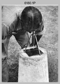
Photograph - RASvy Surveyors in the field, c1950s – 1960s
... Unidentified surveyor undertaking observations using a plane table. .10) – Photo, black & white, c1955, Jorge Gruszka undertaking observations with a theodolite. 7/55 Basic Survey Course Balcombe. .11) – Photo, black & white, c1950s, Jorge Gruszka undertaking observations with a theodolite. .12) – Photo, black & white, c1946-1948, unidentified surveyor undertaking observations with a theodolite to gain control for the mapping of the Snowy Mountain Diversion Scheme. .13) – Photo, black & white, c1950s, unidentified surveyor cutting a blaze in a tree. .14) and .15) – Photo, black & white, c1960s, Jim Stedman demonstrating EDM equipment. .16) – Photo, black & white, c1960s, L to R: Jim Stedman (probably) and unidentified surveyor demonstrating EDM equipment. .17) – Photo, black & white, 1956, Operation Cutlass - Surveyors SPR W. ...Unidentified surveyor undertaking observations using a plane table. .10) – Photo, black & white, c1955, Jorge Gruszka undertaking observations with a theodolite. 7/55 Basic Survey Course Balcombe. .11) – Photo, black & white, c1950s, Jorge Gruszka undertaking observations with a theodolite. .12) – Photo, black & white, c1946-1948, unidentified surveyor undertaking observations with a theodolite to gain control for the mapping of the Snowy Mountain Diversion Scheme. .13) – Photo, black & white, c1950s, unidentified surveyor cutting a blaze in a tree. .14) and .15) – Photo, black & white, c1960s, Jim Stedman demonstrating EDM equipment. .16) – Photo, black & white, c1960s, L to R: Jim Stedman (probably) and unidentified surveyor demonstrating EDM equipment. .17) – Photo, black & white, 1956, Operation Cutlass - Surveyors SPR W. ...This is a set of 1photographs of surveyors in the field measuring distances using chains, taking observations using theodolites and operating electric distance measurement equipment. They were probably employed in establishing mapping and geodetic control operations or the surveyors may have been in training. The photos were most likely taken in the 1950s and 1960s. Photos .1P to .6P feature personnel setting up geodetic survey chaining equipment to measure distances. The surveyor in Photo .5P is LTCOL Howard Angus Johnson MBE who served from 1936 to 1954. The RA Svy surveyor in photos .7P to .12P were using a theodolite to take angular measurements. They were usually supported by an observer who recording their readings on a booking form. The surveyor in Photo .10P and .11P is LTCOL Jorge Gruszka, who served from 1955 to 1985. He was CO of the Army Survey Regiment from 1982 to 1985. The surveyor in photo .13P is cutting an identification blaze on a tree using a hammer and chisel. The tellurometer in Photos .14P to .16P was a MRA1 microwave Electronic Distance Measuring instrument (EDM) introduced in 1958. It and later models were man-portable systems that improved geodetic survey efficiencies for rapid network extension and densification replacing triangulation with EDM and theodolite traverse sometimes using Bilby Towers to extend line lengths. The surveyor with the slouch hat is Colonel James ‘Jim’ Leslie Stedman, who served from 1941 to 1978. He was Director of Military Survey from 1975 to 1978 and was appointed as Colonel Commandant (honorary appointment, Retd) of the Royal Australian Survey Corps from 1978 to 1983. Jim Stedman is demonstrating EDM equipment.This is a set of 17 photographs of surveyors in the field measuring distances using chains, taking observations using theodolites and operating electric distance measurement (EDM) equipment. c1950s – 1960s. The photographs were printed on photographic paper and are part of the Army Survey Regiment’s Collection. The photographs were scanned at 300 dpi. .1) - Photo, black & white, c1950s, unidentified personnel using geodetic survey chaining equipment. .2) to .4) - Photo, black & white, c1950s, geodetic survey chaining equipment. .5) – Photo, black & white, c1950s, Jim Stedman using geodetic survey chaining equipment to measure distances. .6) - Photo, black & white, c1950s, Unidentified personnel geodetic survey chaining equipment. .7) – Photo, black & white, mounted on card, c1950s. Unidentified surveyor undertaking observations on a coral reef using a theodolite. .8) – Photo, black & white, c1950, unidentified surveyor undertaking observations with a Tavistock theodolite. .9) – Photo, black & white, mounted on green card, c1950s. Unidentified surveyor undertaking observations using a plane table. .10) – Photo, black & white, c1955, Jorge Gruszka undertaking observations with a theodolite. 7/55 Basic Survey Course Balcombe. .11) – Photo, black & white, c1950s, Jorge Gruszka undertaking observations with a theodolite. .12) – Photo, black & white, c1946-1948, unidentified surveyor undertaking observations with a theodolite to gain control for the mapping of the Snowy Mountain Diversion Scheme. .13) – Photo, black & white, c1950s, unidentified surveyor cutting a blaze in a tree. .14) and .15) – Photo, black & white, c1960s, Jim Stedman demonstrating EDM equipment. .16) – Photo, black & white, c1960s, L to R: Jim Stedman (probably) and unidentified surveyor demonstrating EDM equipment. .17) – Photo, black & white, 1956, Operation Cutlass - Surveyors SPR W. Crane and J.A. Campbell undertaking observations with a theodolite in extreme conditions..1P on back - First Order Chaining Equipment .2P on back - First Order Chaining Equipment .3P on back - Full catenary 1800 – 1960 replaced by EDM .4P on back - First Order Chaining Equipment .5P on back - H.A. Johnson, Benambra baseline? 1st Order Chaining .6P on back - Chaining .7P on front - Difficult observing conditions especially when the tide is in. The station is sighted (sic) on a coral reef. .8P on back - Tavistock. .10P on back of duplicate in Photo Folder 14 – George (sic) Gruszka 7/55 Basic Survey Course Balcomme (sic) 1955/56 .14P and .15P on back - Jim Stedman demonstrating early EDM equipment.royal australian survey corps, rasvy, army survey regiment, army svy regt, fortuna, asr, surveying -
 Bendigo Military Museum
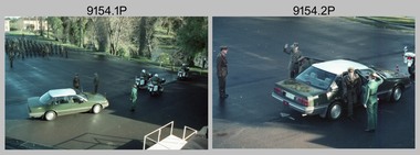
Photograph - Army Survey Regiment – Corps Day Parade Set 2, Fortuna Villa, Bendigo, 1991
... SPR Damian Nolan stands on the corner of the parade ground behind a Plane Table Board with an alidade mounted 3MD Band stands at attention during the inspection. ...SPR Damian Nolan stands on the corner of the parade ground behind a Plane Table Board with an alidade mounted 3MD Band stands at attention during the inspection. ...This set of 37 photographs was taken at the Corps Day Parade held at the Army Survey Regiment, Bendigo on the 26th of June 1991.The Corps Day Parade was held to commemorate the 76th anniversary of the formation of the Royal Australian Survey Corps. The Reviewing officer was the Commander of the 3rd Military District BRIG P. Davies AM ADC and the Parade Host was D-SVY COL Simon Lemon. Refer to items 9152.31P for more photographs taken during the parade; and 9155.27P for photographs taken afterwards during the tour of the unit and the family BBQ.This is a set of 37 photographs of the Corps Day Parade held at the Army Survey Regiment, Fortuna, Bendigo on the 26th of June 1991. The colour photographs are on 35mm negative film and scanned at 2400 dpi. They are part of the Army Survey Regiment’s Collection. .1) - Photo, colour, 1991. Arrival of COMD 3MD. L to R: D-SVY - COL Simon Lemon, unidentified personnel, unidentified Aide-de-camp. .2) to .4) - Photo, colour, 1991. Arrival of COMD 3MD. L to R: D-SVY - COL Simon Lemon, COMD 3MD - BRIG P. Davies AM ADC, unidentified Aide-de-camp, unidentified personnel. .5) - Photo, colour, 1991. Cartographic Squadron stands at attention, under command of OC MAJ Graeme Wastell. .6) - Photo, colour, 1991. Headquarters Squadron stands at attention, under command of OC MAJ Peter Jensen. 2IC MAJ Ray Redman at left. .7) - Photo, colour, 1991. Air Survey Squadron stands at attention. L to R: LT Simon Buckpitt, WO1 Brett ‘Dutchy’ Van Leeuwen, unidentified (x2), CPL Perry Burt, SGT Sandy Craig, SGT Graeme Reany, SPR Stuart Bowd, LT Michelle Breen in foreground, unidentified, SGT Wolfgang Thun, SSGT Bruce Hammond, unidentified, SGT Paul Hopes, WO1 Russell ‘Rusty’ Williams. .8) - Photo, colour, 1991. Air Survey Squadron at attention under command of OC MAJ Peter Clark - at far left during the inspection. L to R: LT Simon Buckpitt, CO LTCOL Rene van den Tol, unidentified Aide-de-camp, LT Michelle Breen in foreground. At her right L to R: COMD 3MD - BRIG P. Davies AM ADC, SGT Graeme Reany, SPR Stuart Bowd, unidentified, SGT Wolfgang Thun, SSGT Bruce Hammond, unidentified, SGT Paul Hopes, WO1 Russell ‘Rusty’ Williams. .9) - Photo, colour, 1991. Air Survey Squadron inspection. L to R: D-SVY - COL Simon Lemon, COMD 3MD - BRIG P. Davies AM ADC, SPR Steve Linane, SPR Derek Percival. .10) & .11) - Photo, colour, 1991. Air Survey Squadron inspection. SSGT Graham Johnston at far left. L to R: CO LTCOL Rene van den Tol, unidentified Aide-de-camp, D-SVY - COL Simon Lemon, COMD 3MD - BRIG P. Davies AM ADC, SPR John ‘Docc’ Commons, unidentified (x4), SPR Jo (Innes) Thun, SGT Peter Tuddenham, SSGT Bob Garritty, SGT Martin Evans. .12) - Photo, colour, 1991. Air Survey Squadron inspection. L to R: CO LTCOL Rene van den Tol, unidentified Aide-de-camp, D-SVY - COL Simon Lemon, COMD 3MD - BRIG P. Davies AM ADC, SPR John ‘Docc’ Commons, unidentified (x4), SPR Jo (Innes) Thun, SGT Peter Tuddenham, SSGT Bob Garritty, SGT Martin Evans. Unidentified WO2 in right background. .13) & .14) - Photo, colour, 1991. SPR Peter Smyth stands on the corner of the parade ground behind an MRA-7 Tellurometer mounted on a tripod. .15) & .16) - Photo, colour, 1991. SPR Damian Nolan stands on the corner of the parade ground behind a Plane Table Board with an alidade mounted 3MD Band stands at attention during the inspection. L to R: unidentified Aide-de-camp, unidentified 3MD Band Master, D-SVY - COL Simon Lemon, COMD 3MD - BRIG P. Davies AM ADC, unidentified members of 3MD Band.on a tripod. .17) - Photo, colour, 1991. The unidentified 3MD Band Master salutes COMD 3MD - BRIG P. Davies AM ADC before the 3MD Band inspection. .18) - Photo, colour, 1991. 3MD Band stands at attention during the inspection. L to R: unidentified Aide-de-camp, unidentified 3MD Band Master, D-SVY - COL Simon Lemon, COMD 3MD - BRIG P. Davies AM ADC, unidentified members of 3MD Band. .19) - Photo, colour, 1991. Army Survey Regiment at ‘Shoulder Arms’ position in readiness for the Present Arms’ salute. CO LTCOL Rene van den Tol at front. .20) - Photo, colour, 1991. Cartographic and Air Survey Squadrons at ‘Shoulder Arms’ position in readiness for the Present Arms’ salute. CO LTCOL Rene van den Tol at front. .21) - Photo, colour, 1991. Headquarters Squadron at ‘Shoulder Arms’ position in readiness for the Present Arms’ salute. L to R: 2IC MAJ Ray Redman, MAJ Bob Williams, OC MAJ Peter Jensen. CAPT Colin Cuskelly. .22) & .23) - Photo, colour, 1991. Army Survey Regiment under CO LTCOL Rene van den Tol’s command salutes the COMD 3MD with ‘Present Arms’. .24) - Photo, colour, 1991. L to R: COMD 3MD - BRIG P. Davies AM ADC, D-SVY - COL Simon Lemon, unidentified Aide-de-camp. .25) - Photo, colour, 1991. The squadrons remove their hats in readiness for ‘Three cheers for Her Majesty the Queen’. .26) & .27) - Photo, colour, 1991. The squadrons cheer in unison to the command ‘Three cheers for Her Majesty the Queen’. .28) - Photo, colour, 1991. The unidentified padre addresses the Parade. .29) - Photo, colour, 1991. COMD 3MD - BRIG P. Davies AM ADC, addresses the Parade. .30) - Photo, colour, 1991. D-SVY - COL Simon Lemon addresses the Parade. .31) & .32) - Photo, colour, 1991. COMD 3MD - BRIG P. Davies AM ADC presents the Defence Force Service Medal with clasp to WO1 Brett ‘Dutchy’ Van Leeuwen for 20 years of efficient remunerated service. .33) - Photo, colour, 1991. The 3MD Band marches towards the front steps of Fortuna Villa. .34) - Photo, colour, 1991. The 3MD Band salutes as it marches past the official guests on the front steps of Fortuna Villa. .35) - Photo, colour, 1991. Lithographic Squadron led by OC MAJ Bob Coote marches towards the front steps of Fortuna Villa. .36) - Photo, colour, 1991. Lithographic Squadron led by OC MAJ Bob Coote salutes as it marches past the official guests on the front steps of Fortuna Villa. .37) - Photo, colour, 1991. COMD 3MD - BRIG P. Davies AM ADC salutes the passing troops. L to R: D-SVY - COL Simon Lemon, unidentified UK Liaison Officer, BRIG P. Davies AM ADC, unidentified Aide-de-camp.There are no personnel identified. ‘Corps Day 26 Jun 1991’ annotated on negative sleeves.royal australian survey corps, rasvy, army survey regiment, army svy regt, fortuna -
 Bendigo Military Museum
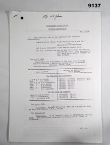
Administrative record - Australian Survey Corps - Liaison Letters 1936 - 1939, 1st, 2nd, 3rd and 4th Military Districts, Australia, July 1936 - June 1939
... Azimuth of the Plane table. -- Article missing. .... W.O. B. ...Azimuth of the Plane table. -- Article missing. .... W.O. B. ...Liaison Letters details happenings within the various Sections of the Australian Survey Corps to inform all members of current information and practices. 9137.1 Liaison Letter No 1. 21 July 1937. Para 1. Object of Letter. See context section. Para 3. Progress of work. Incomplete, rest of Letter missing only 1 page. 9137.2 Liaison Letter No 2 Letter missing. 9137.3 Liaison Letter No 3. Jan 1937. Para 1. Our thanks are due to the following for articles contributed. .... W/O H. Rossiter. -- "Aerial Surveying". -- Article missing. .... W/O W. M. Sarll. -- "A day in the Draughting Office". -- Report on No 1 Field Sheet, Sale. -- Article missing. .... W/O H. A. Johnson. -- "Semigraphic methods of resection and intersection". -- Article missing. .... Capt. J.J. Raisbeck "Rapid production and reproduction of Military maps". Article missing. .... Lt. L. Fitzgerald. report "Survey Exercise at Sale". Article missing. .... W/O W. M. Sarll. report on No1. Field Sheet, Sale. Article missing. Para 3. Progress of work. .... "No1 Draughting Section". .... Printing. .... No1 Survey Section. .... No2 Survey Section. .... Pages 3 - 6 Missing. .... Article by W/O W. M. Sarll. "A day in the Draughting Office". Pages 7 - 10. 9137.4 Liaison Letter No 4. April 1937. Para 1. Our thanks are due to the following for articles contributed. .... Lieut. H. W. G. Clews. -- Notes on the non-ascertained Base problem. -- Article missing. .... W/O W. M. Sarll. -- Helpful hints on air photos. -- Article missing. .... Capt. T. H. B. Foott. .... & Capt. J.J. Raisbeck. -- A short history of the Military Survey of Australia. -- Article missing. .... W/O H. Rossiter. -- Notes on Aerial Surveying. -- Article missing. .... W/O H. A. Johnson. -- A type of Beacon. -- Article missing. Para 2. Progress of work. ..... No1 Draughting Section. ..... No1 Survey Section. ..... Pages missing. 9137.5 Liaison Letter No 5, July 1937. Para 1. Our thanks are due to the following for articles contributed .... Lt L. Fitzgerald -- A new section and its job. -- Article missing. .... WO G.R.L. Remington. .... & H. E. Eggeling. Azimuth of the Plane table. -- Article missing. .... W.O. B. M. Sarll. -- The Second Annual Smoke Night of the Members of the Aust.Survey Corps stationed in Victoria. .... Also included is a very interesting article on the United States Geological Survey by J. F. Staask, extracted from the Canadian Surveyor. February 1936. -- Article missing. Para 2. Progress of work. .... No1. Draughting Section. .... No 1 Topographical Section. No further articles till page 7. .... The Second Annual Smoke Night of the members of the Aust. Survey Corps. Stationed in Victoria. Pages 7 - 9. 9137.6 Liaison Letter No 6, September 1937. Para 1. Our thanks are due to the following for articles contributed .... Lt L. Fitzgerald. -- Geodetic Triangulation reconnaissance. Article missing. -- Article missing. .... Lt. R.F. Rule, M.M. -- A suggested Form for Field Book 3rd Order Traverses. -- Article missing. .... W/O. H. A. Johnson. -- A suggested Form for Quadrilateral Adjustments. -- Article missing. Para 2. Progress of work. .... No1. Draughting Section. .... No 1 Topographical Section. No further pages to letter 6. 9137.7 Liaison Letter No 7. January 1938. Para 1. Our thanks are due to the following for articles contributed. .... Major T. A. Vance. -- Report on the Survey of a Training Area in Tasmania. -- Article missing. .... W/O D. Macdonald. -- The naming of Trigonometrical Stations. -- Article missing. Para 2. Progress of work. .... No1 Draughting Section A.H.Q. .... No1 Topographical Section, 4 M.D. .... No2 Topographical Section 3 M.D. .... No3 Topographical Section 2 M.D. .... No4 Topographical Section A.H.Q. No further pages to letter 7. 9137.8 Liaison Letter No 8. April 1938. Para 1. Our thanks are due to the following for articles contributed .... Capt. H.P.G.Clews. -- A possible method of estimating Stereoscopic ability. -- Article missing. .... W/O. A.L.Smith. -- Hints to Topographers from a Draughtsman's point of view. .... W/O. W.W. Sarll. -- Seeing that which a Surveyor sees. Para 1.a. -- Relative to article on naming of trig stations which appeared in No7. This contribution has examples of naming. Para 1.d. Enlistment. -- George Gladstone Bolwell was enlisted as W/O.II. Draughtsman in the No. 1 Draughting Section A.H.Q. on the 26th April 1938. Mr. Bolwell was of the Victorian Lands Department. Para 1.e. Embarkation. -- Major T.A. Vance. O.C. Aust Survey Corps, embarked S.S. "Monterey". 28 Mar 1938 to undergo six months training in USA and Canada. Para 1.f. Promotions. -- To be Capt. (prov.) Lieut. H.P.G. Clews 9.11.1937. Para 1.g. Medals -- Award of Aust. Meritorious Service Medal -- W/O.H. Rossiter. .... Award of Aust. Medal for Long Service and Good Conduct -- W/O, A.L. Smith. Para 2. Progress of work. .... No.1 Draughting Section A.H.Q. .... No.1 Topographical Section, 4 M.D. .... No.2 Topographical Section 3 M.D. .... No.3 Topographical Section 2 M.D. .... No.4 Topographical Section A.H.Q. Article missing by Capt. H.P.G.Clews. -- A possible method of estimating Stereoscopic ability. Article by W/O. A.L.Smith. -- Hints to Topographers from a Draughtsman's point of view. Contains 3 pages. Article by W/O. W.W. Sarll. -- Seeing that which a Surveyor sees. Contains 3 pages. 9137.9 Liaison Letter No 9. July 1938. Para 1. Our thanks are due to the following for articles contributed .... Captain H.P.G.Clews -- Computation of log p and log v; also Abbreviated interpolation. .... W/O. G.R.L. Rimington. -- Light Weight Camping Gear. .... W/O. H.A. Johnson. -- The use of the Calculating Machine on Resections, etc,; also comments by O.C.No.4 Topographical Section on this article. Para 1.a. A.A.O. 104. Examination for Appointment to the Rank of Lieutenant. February - March,1938. .... W.O.I. A.L. Smith. .... W.O.I. W.M. Sarll. .... W/O. II. G.R.L. Rimington. .... W/O. II. A.F. Kurrle. .... W/O. II. H.A. Johnson. .... W/O. II. D. MacDonald. .... W/O. II. H.F.Eggeling. .... For Captain. .... Capt. (p) H.P.G. Clews. .... Lieut. L. FitzGerald. .... Lieut. R.K. Rule M.M. Para.1. b. A.A.O. 109. Allotment W/O. II. W.B. Relf to No.3 Topo Section 2 M.D., 5.4.38. Para.1. c. Gaz. No. 37 -- Promotions. -- To be Captain, Lieut. L FitzGerald. 5th July 1938. -- The provisional promotion of Captain H.P.G. Clews is confirmed. Para. 2. Progress of Work. .... No.1 Draughting Section A.H.Q. .... No.1 Topographical Section, 4 M.D. .... No.2 Topographical Section 3 M.D. .... No.3 Topographical Section 2 M.D. .... No.4 Topographical Section 2 M.D. 9137.10 Liaison Letter No 10. October 1938. Para 1. Our thanks are due to the following for articles contributed. .... Lieut. R.K. Rule M.M. -- Barometric levelling in Forest Areas. .... W/O. H.A. Roseblade -- Adjustment of principal points on master grid. .... W/O. II. A.F. Kurrle. -- The Hunter short base applied to photo control. .... W/O. W.B. Relf -- Reunion at Newcastle. .... The articles are all missing Para. 1. a. A.A.O. 184. Discharge -- W/O. II. G.G. Bolwell. 15th July 1938. Para. 1. b. A.A.O. 174-195, 31.8.38. Vacancy for Draughtsman. Para. 1. c. Obituary. -- Major John Lynch. 29th July 1938. Para. 2. Progress of Work. .... No.1 Draughting Section A.H.Q. .... No.1 Topographical Section, 4 M.D. .... No.2 Topographical Section 3 M.D. .... No.3 Topographical Section 2 M.D. .... No.4 Topographical Section A.H.Q. 9137.11 Liaison Letter No 11. January 1939. Para 1. Our thanks are due to the following for articles contributed. .... Major T.A. Vance. -- Training Abroad, Canada and U.S.A. .... Captain L. Fitzgerald -- Air Reconnaissance for 1st Order Triangulation. .... W/O C.E. Stewart. -- Reunion at Traralgon. Para 2. A.A.O. 301/38. .... a. Appointments. -- Royal Ormond Worcester, on enlistment in the Aust Permanent Military Forces is appointed W/O II. 30th November 1938. -- Thomas Micheal Connolly, on enlistment in the Aust Permanent Military Forces is appointed W/O II. 30th November 1938. .... b. Discharge. -- No. 3614 W/O II. G.R.L. Rimington. 30th November 1938. .... c. Awards of the Australian Military Medal for Long Service and Good Conduct (Military). -- No.1175, W/O I, E.T. Johnson. .... d. Return of Officers to Australia. -- Major T.A. Vance, having completed training in the United States of America, Canada and New Zealand, returned to Aust. on the S.S. "Awatea", disembarked Sydney on 3rd December 1938. .... e. Allotment. -- No.3689, W/O. II A.F. Kurrle, allotted to No. 4 Topographical Section, A.H.Q., 1 January 1939. Para. 2. Progress of Work. .... Cartographic Section, A.H.Q. .... Geodetic Section, A.H.Q. .... No.1 Survey Section, 4 M.D. .... No. 2 Survey Section, 3 M.D. .... No. 3 Survey Section, 2 M.D. 9137.12 Liaison Letter No 12. March 1939. Para 1. Our thanks are due to the following for articles contributed. .... W/O H.F. Eggeling -- Topographical Survey and Barometric Levelling. .... W/O G.T.P. Carter Methods of plotting from air photographs. .... Editor, Canadian Surveyor -- The Australian Survey Corps Para 2. A.A.O. 57 -- .... a. Promotion. -- No. 3577 S/Sgt G.T.P. Carter. appointed Topographer promoted to W/O II. 15th January 1939. .... b. Allotment -- The following are allotted to No. 3 Topographical Section 2 M.D. 1st February 1939. .... No, 171 W/O I B. Rossiter. .... No. 178 W/O. I V.W. Aldred. .... No. 150 W/O. I A.T. Smith. .... c. Transfer. -- No. 369 W.O. A.F.Kurrle. to No. 4 Topo Section A.H.Q. 1st January 1939. .... d. Promotions -- To be Major J.J. Raisbeck. and Lieut. W.M. Sarll as of 1st January 1939. Para. 3. Progress of Work. .... Cartographic Section, A.H.Q. .... No.4 Topographical Section, A.H.Q. .... No.2 Topographical Section, 3 M.D. .... No.3 Topographical Section, 2 M.D. .... Articles Missing -- W/O H.F. Eggeling -- Topographical Survey and Barometric Levelling. -- W/O G.T.P. Carter Methods of plotting from air photographs .... Article -- Editor, Extract from "The Canadian Surveyor" -- The Australian Survey Corps. 9137.13 Liaison Letter No 13. June 1939. Para 1. Our thanks are due to the following for articles contributed. .... Lieut. W.M. Sarll -- Meeting a crisis with maps and equipment; also comments by O.C. Cartographic Section. .... W/O H.F. Eggeling -- Design and description of an Epidiascope. -- Article missing. .... Editor, Melbourne Herald -- "They do a Vital Task". 6th July, 1939. .... Also enclosed is a Corps Seniority Roll. -- Article missing. Para 2. a. A.A.O. 118/39. -- Appointment to Lieutenant, February, March, 1939. .... 3572 W/O. I. H.C. Raisbeck. .... 3684 W/O. I.I. T.R. Westgarth. .... 3686 W/O. I.I. C.E.B. Stewart. .... 3702 W/O. I.I. C. S. Tyler. .... 4479 W/O. I.I. W.B. Relf. Para. 2. b. A.A.O. 127/39 -- Appointment to W/O. I.I. .... G. V. Brooke. 5.4.39. .... L. J. Lockwood. 5.4.39. .... J. P. Hanley. 17.4.39. .... W. J. Harrison. 24.4.39. .... J. K. C. Herridge. 1.5.39. Para 2. c Gaz. 26/39. Awards of the Aust. Medal for Long Service and Good Conduct Military. .... No. 1439 W/O. I. H. A. Roseblade. .... No. 1176 W/O. I. J. Cullen. Para. 3. Progress of Work. .... Cartographic Section, A.H.Q. .... Geodetic Section A.H.Q. .... No. 2 Survey Section, 3 M.D. .... No. 3 Survey Section, 2 M.D. .... Editor, Melbourne Herald -- "They do a Vital Task". 6th July, 1939. .... Lieut. W.M. Sarll -- Meeting a crisis with maps and equipment; also comments by O.C. Cartographic Section. 9137.1 Liaison Letter No 1. 21 July 1937. Para 1. Object of Letter. The object of these letters, which it is to be proposed quarterly, is to enable members of the Australian Survey Corps to stimulate interest in the progress of the work as a whole. It is also intended as a means to invite helpful criticism and suggestions for improvements in methods in any branch of the work. All members of the Corps are invited to contribute. Their suggestion should be forwarded to the O.C. section for transmission to O, C. Survey Corps and, if considered of sufficient merit, will be included in the next letter. It may often happen that a method, that may appear obvious and of little consequence to a member or Section using it, may not be followed by the others. In any case a discussion of detail in methods should be helpful to all.54 x A4 Photocopied pages of typed text. 9137.1 Liaison Letter No 1. 21 July 1937. 9137.2 Liaison Letter No 2 Letter missing. 9137.3 Liaison Letter No 3. Jan 1937. 9137.4 Liaison Letter No 4. April 1937. 9137.5 Liaison Letter No 5, July 1937. 9137.6 Liaison Letter No 6, September 1937. 9137.7 Liaison Letter No 7. January 1938. 9137.8 Liaison Letter No 8. April 1938. 9137.9 Liaison Letter No 9. July 1938. 9137.10 Liaison Letter No 10. October 1938. 9137.11 Liaison Letter No 11. January 1939. 9137.12 Liaison Letter No 12. March 1939. 9137.13 Liaison Letter No 13. June 1939. royal australian survey corps, army survey regiment, fortuna, rasvy, army svy regt, asr -
 Warrnambool and District Historical Society Inc.
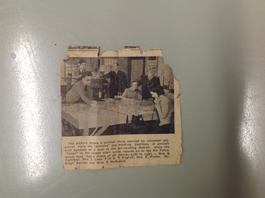
Article, Newspaper S McDonald, 1940’s
... planes left to right Mrs. S Hamilton, Mrs. J Lees, F/O E F English, Mrs. R Picton, Mr. Ralph Barnes and Miss S McDonald Small newspaper cutting with photograph with six people around a table. ...The Volunteers Air Observers was formed in 1941 with the aim of observing aircraft flying over Australia. There were over 24000 civilians volunteering their services and as the military threat to Australia subsided they took on roles as coast and weather watching. This photograph shows a group of local volunteers at their work. Mrs. S Hamilton, Mrs. J Lees, F/O E F English, Mrs. R Picton, Mr. Ralph Barnes and Miss S McDonaldA local item which relates to an organization which operated around Australia in the 1940’s. Small newspaper cutting with photograph with six people around a table. Text is underneath the photo. The back has an advertisement for Fletcher Jones clothingThe picture shows a control room manned by volunteer personnel. Here the plotters are marking positions of aircraft with symbols on a map of the surrounding district while the Teller in the raised chair sends reports on to the Air Force, which thus has a check of all planes left to right Mrs. S Hamilton, Mrs. J Lees, F/O E F English, Mrs. R Picton, Mr. Ralph Barnes and Miss S McDonald volunteer air observers corps,, volunteer air observers corps,, mrs. s hamilton,, mrs. j lees,, f/o e f english, mrs. r picton, mr. ralph barnes, miss s mcdonald warrnambool -
 Bendigo Military Museum
Postcard - POSTCARDS
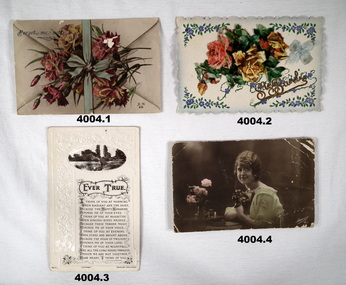
... table. On rear in black pencil addressed to “Dear Lena”, signed off “love to all George, France 9th October 1916”. (.5) Silk postcard, colour showing a scene with 2 dwellings, trees, mountains in the background, under in silk knitted “A Merry Xmas”. On the rear in black pen, “To dear cousin Lena”, signed off “From your loving cousin George, France 31st October 1916”. (.6) Postcard B & W showing a large building in rear with a German plane centre, gun and carriage titled “war trophies taken from the Germans”. ...table. On rear in black pencil addressed to “Dear Lena”, signed off “love to all George, France 9th October 1916”. (.5) Silk postcard, colour showing a scene with 2 dwellings, trees, mountains in the background, under in silk knitted “A Merry Xmas”. On the rear in black pen, “To dear cousin Lena”, signed off “From your loving cousin George, France 31st October 1916”. (.6) Postcard B & W showing a large building in rear with a German plane centre, gun and carriage titled “war trophies taken from the Germans”. ...(.1, .2, .7 .8) These are all in pencil with similar hand writing. The others are similar writing in pen and pencil. There are two “Georges”, George RICHARDSON and George HARGREAVES. Refer Cat No 4003.3P for their photos. refer Cat No 3996P re “Lena” and other cards, photos that were in a collection relating to her.(.1) Postcard, colour showing a bouquet of flowers, bow with “forget me not” in the left hand corner. Letter is written in black pencil addressed to “Dear Lena from your friend George, Jan 7th 1916”. (.2) Postcard, colour showing floral arrangements with a blue silk bow attached on the right hand side, cerrated edging with gold lettering which appears to be “Ste Barb”. On the rear in black pencil, “To Lena with love from George, Jan 7th 1916. (.3) Postcard B & W showing a lake scene in oval shape at top with a poem under titled “Evertrue”. On the rear written in black pen addressed to “Dear Lena”, signed off “I remain your ever loving friend George, Friday March 17th 1916”. (.4) Postcard, colour showing a women seated at a table holding a bouquet, vase of roses on table. On rear in black pencil addressed to “Dear Lena”, signed off “love to all George, France 9th October 1916”. (.5) Silk postcard, colour showing a scene with 2 dwellings, trees, mountains in the background, under in silk knitted “A Merry Xmas”. On the rear in black pen, “To dear cousin Lena”, signed off “From your loving cousin George, France 31st October 1916”. (.6) Postcard B & W showing a large building in rear with a German plane centre, gun and carriage titled “war trophies taken from the Germans”. On the rear in black pen addressed to “Dear Lena”, signed off “With love to you all George, 2 Nov 1916 France”. (.7) card, folding, colour, Rising Sun at top, flags centre with “57th Battalion AIF” under then “Xmas 1916”. A small bow in red and black attached. Inside printed “With best wishes from your boys in France”. In black pencil addressed to “Lena”, signed off “With best love George, Nov 13 1916”. (.8) Postcard, silk showing 3 red flowers hanging with a scroll underneath with the wording in gold, “Sincere friendship” On the rear in black pencil addressed to “Dear Lena”, signed off, “Your ever loving friend George, 17.8.1917 France”. (.9) Postcard, colour showing portrait of a women in a blue dress with 3 bouquets of flowers on her front. On the rear in black pen addressed to “Dear Lena”, signed off, “With best love and kisses, yours George Hargreaves, France April 11th 1918”.postcards, ww1 -
 Flagstaff Hill Maritime Museum and Village
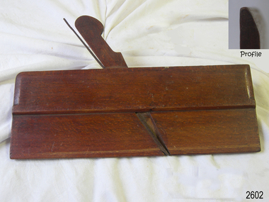
Tool - Wood Moulding Plane, George Hathersich, 1797-1851
... Moulding planes are used to create decorative edges on timber for doors, tables, cabinets and elaborate cabinetry....Moulding planes are used to create decorative edges on timber for doors, tables, cabinets and elaborate cabinetry. ...George Hathersich made wood moulding planes at 30 Shade Hill Street, Manchester, England, from 1797 to 1851. After his death, his wife, Elizabeth, carried on making planes. Moulding planes are used to create decorative edges on timber for doors, tables, cabinets and elaborate cabinetry.The maker, Hathersich, was a very early plane maker from Manchester, England. Hathersich's early 19th-century hand-operated planes are rare examples of crafted woodworking tools. Similar tools are still made today and used by specialists in cabinet and woodcraft trades.Plane; hand-operated mounding plane, round type. A narrow rectangular plane with a wooden wedge and an iron blade inserted in the bed. The wooden surface is stained and varnished. It has inscriptions. Made by George Hathersich of Manchester, UK. Also marked C S Schofield. "Hathersich" "C S Schofield"flagstaff hill, flagstaff hill maritime museum and village, warrnambool, maritime museum, maritime village, great ocean road, shipwreck coast, wood work, builder, carpenter, wood worker, woodworking, plane, moulding plane, tool, woodworking tool, george hathersich, shudehill, manchester, england, c s schofield -
 Federation University Historical Collection
Book, Ballarat School of Mines, Ballarat School of Mines Calendar, 1911, 1911
... Plan of Buildings and Grounds Engineers with qualifications from the Ballarat School of Mines were sought by mines throughout the world. ballarat school of mines scientific equipment engineering classroom desks gas lighting calendar r. maddern j. m. bickett w. h. middleton j. d. woolcott w. nixon daniel. walker fred j. martell professor a. mica smith hubert r. murphy charles a. deane arthur garrard professor t. s. hart professor a. d. gilchrist a. e. c. kerr j. brittain e. j. a. mcconnon john m. sutherland bertram whitington h. j. hall e. gutheil charles campbell t. williams d. e. mullins sir redmond barry judge rogers r. m. sergeant thomas bath andrew anderson general regulations discipline discipline board associateship and final certificates mining engineering metallurgy geology electrical engineering certificate courses junior technical school fees subjects of instruction chemistry geological department engineering department electrical engineering department department of mathematics and physics practical plane and solid geometry photography full certificates issued supplementary examination results - may 1910 supplementary examination results - april 1908 subscriptions and donations 1910 Blue soft covered book of 64 pages titled the Ballarat School of Mines Calendar. The book includes images of the Engineering Room, the Maddern Roasting Furnace, Museum, Junior Chemical Laboratory, Plan of Buildings and Ground, Chemical Laboratory, Concentration Floor, Linkenbach Table, Engineering Laboratory, Experimental Steam Engine, Chemical Lecture Room, Physics Instruction Room, Newtonian Telescopy, Ballarat Observatory, Instructor's Laoratory, Wilfrey Table, Chlorination plant, Cyanide House and R. ...In 1911 R. Maddern was President of the Ballarat School of Mines. Contents of this booklet are: Asssociateship, Calendar, Certificate Courses, Departmental Regulations, Discipline, Discipline Board, Examination Results, Fees, Full Certificates Issued, General Regulations, Introduction, Junior Technical School, Officer Bearers, Professors and Lecturers, Subjects of Instruction - Department of Chemistry and Metallurgy, Geological Department, Engineering Department, Electrical Engineering Department, Department of Mathematics and Physics, Practical, Plane and Solid Geometry, Photography, Subscriptions and Donations 1910. Plan of Buildings and Grounds Engineers with qualifications from the Ballarat School of Mines were sought by mines throughout the world. Blue soft covered book of 64 pages titled the Ballarat School of Mines Calendar. The book includes images of the Engineering Room, the Maddern Roasting Furnace, Museum, Junior Chemical Laboratory, Plan of Buildings and Ground, Chemical Laboratory, Concentration Floor, Linkenbach Table, Engineering Laboratory, Experimental Steam Engine, Chemical Lecture Room, Physics Instruction Room, Newtonian Telescopy, Ballarat Observatory, Instructor's Laoratory, Wilfrey Table, Chlorination plant, Cyanide House and R. Maddern. ballarat school of mines, scientific equipment, engineering, classroom, desks, gas lighting, calendar, r. maddern, j. m. bickett, w. h. middleton, j. d. woolcott, w. nixon, daniel. walker, fred j. martell, professor a. mica smith, hubert r. murphy, charles a. deane, arthur garrard, professor t. s. hart, professor a. d. gilchrist, a. e. c. kerr, j. brittain, e. j. a. mcconnon, john m. sutherland, bertram whitington, h. j. hall, e. gutheil, charles campbell, t. williams, d. e. mullins, sir redmond barry, judge rogers, r. m. sergeant, thomas bath, andrew anderson, general regulations, discipline, discipline board, associateship and final certificates, mining engineering, metallurgy, geology, electrical engineering, certificate courses, junior technical school, fees, subjects of instruction, chemistry, geological department, engineering department, electrical engineering department, department of mathematics and physics, practical, plane and solid geometry, photography, full certificates issued, supplementary examination results - may 1910, supplementary examination results - april 1908, subscriptions and donations 1910 -
 Federation University Historical Collection
Book, Ballarat School of Mines Calendar, 1902-3, 1901
... Associateship and Final Certificates, Calendar for 1903, Discipline, Discipline Board, Fees, Full Certificates Issued, General Regulations, Honorary Correspondents, Office Bearers, President's Annual Report, Professors and Lecturers, Results of Examinations Conducted by Education Department 1901, Statistics - Students Attending Lectures, Subscriptions and Donations, Subjects Included in Regulations Technical Schools, Subjects of Instruction - Department of Chemistry and Metallurgy, Geological Department, Engineering Department, Electrical Department, Department of Mathematics and Physics, Practical, Plane and Solid Geometry, Photography, Syllabus for Assaying and Metallurgy, Time Table. ...Associateship and Final Certificates, Calendar for 1903, Discipline, Discipline Board, Fees, Full Certificates Issued, General Regulations, Honorary Correspondents, Office Bearers, President's Annual Report, Professors and Lecturers, Results of Examinations Conducted by Education Department 1901, Statistics - Students Attending Lectures, Subscriptions and Donations, Subjects Included in Regulations Technical Schools, Subjects of Instruction - Department of Chemistry and Metallurgy, Geological Department, Engineering Department, Electrical Department, Department of Mathematics and Physics, Practical, Plane and Solid Geometry, Photography, Syllabus for Assaying and Metallurgy, Time Table. ...The Ballarat School of Mines Calendar and Annual Report 1901. Associateship and Final Certificates, Calendar for 1903, Discipline, Discipline Board, Fees, Full Certificates Issued, General Regulations, Honorary Correspondents, Office Bearers, President's Annual Report, Professors and Lecturers, Results of Examinations Conducted by Education Department 1901, Statistics - Students Attending Lectures, Subscriptions and Donations, Subjects Included in Regulations Technical Schools, Subjects of Instruction - Department of Chemistry and Metallurgy, Geological Department, Engineering Department, Electrical Department, Department of Mathematics and Physics, Practical, Plane and Solid Geometry, Photography, Syllabus for Assaying and Metallurgy, Time Table. Includes several photographs.Green soft covered book of 96 pages, it includes the 1901 Annual Report of the Ballarat School of Mines. Images include: Senior Members of Staff and the Linkenbach Tableballarat school of mines, senior members of staff, linkenbach table, linkenbach, mica smith, dawson, hart, usher, annual report, andrew anderson, james m. bickett, r. t. vale, john warrington rogers, james millhinch bickett, james oddie, henry cuthbert, r. g. middleton, charles kent, robert lambert, andrew berry, fred j. martell, thomas s. hart, g. stephen hart, g. j. dawbarn, engineering department, a. e. c. kerr, lewis a. westcott, edgar a. mcconnon, laboratory assistant, john m. sutherland, electrical department, kerr grant, mathematics and physics, henry j. hall, charles e. campbell, photography -
 Federation University Historical Collection
Book, 'A Treatise on Surveying' by William Gillespie, 1888
... Green and maroon hardcover, bound, 537 pages with Appendix A - Synopsis of Plane Trigonometry, Appendix B - Transversals and separate end section for Traverse Tables. ...Green and maroon hardcover, bound, 537 pages with Appendix A - Synopsis of Plane Trigonometry, Appendix B - Transversals and separate end section for Traverse Tables. ...William M. Gillespie Formerly Professor of Civil Engineering in Union College. Green and maroon hardcover, bound, 537 pages with Appendix A - Synopsis of Plane Trigonometry, Appendix B - Transversals and separate end section for Traverse Tables. Fold out Isogonic Chart for the U.S.A adjacent to title page. 'J A Burritt (Ballarat 1890) 'handwritten in pencil on two consecutive inside cover pages. -
Federation University Historical Collection
Book - Annual Report, Berry, Anderson & Co, Ballarat School of Mines Calendar Year 1901-02 with Annual Report and Balance Sheet for 1900, 1901
... Calendar and Annual Report 1901-02, Associateship and Final Certificates, Calendar for 1902, Certificates issued during 1900 in Metallurgy of Gold and Ore Dressing, Discipline, Discipline Board, Fees, Full Certificates Issued, General Regulations, Honorary Correspondents, Meteorological Observations, Office Bearers, Passes Obtained since 1892 in Final Examinations, President's Annual Report, Professors and Lecturers, Results of Examinations Conducted by Education Department 1900, Statement of Receipts and Expenditure for Year 1900, Statistics - Students Attending Lectures, Subscriptions and Donations, Subjects Included in Regulations Technical Schools, Subjects of Instruction - Department of Chemistry and Metallurgy, Geological Department, Engineering Department, Electrical Department, Department of Mathematics and Physics, Practical, Plane and Solid Geometry, Photography, Time Table ...Barker Library (top floor) Mount Helen goldfields Calendar and Annual Report 1901-02, Associateship and Final Certificates, Calendar for 1902, Certificates issued during 1900 in Metallurgy of Gold and Ore Dressing, Discipline, Discipline Board, Fees, Full Certificates Issued, General Regulations, Honorary Correspondents, Meteorological Observations, Office Bearers, Passes Obtained since 1892 in Final Examinations, President's Annual Report, Professors and Lecturers, Results of Examinations Conducted by Education Department 1900, Statement of Receipts and Expenditure for Year 1900, Statistics - Students Attending Lectures, Subscriptions and Donations, Subjects Included in Regulations Technical Schools, Subjects of Instruction - Department of Chemistry and Metallurgy, Geological Department, Engineering Department, Electrical Department, Department of Mathematics and Physics, Practical, Plane and Solid Geometry, Photography, Time Table annual report 1901-02 andrew anderson - president r. denham pinnock - vice president hon. r.t. vale - vice president the hon. john warrington rogers - trustee the right reverend samuel thornton bishop of ballarat - trustee james millhinch bickett - trustee james oddie - trustee the hon. henry cuthbert - honorary solicitor r. g. middleton - honorary treasurer thomas s. hart - curator of museum chas. kent - auditor fred j. martell - director professor alfred mica smith daniel walker hubert r. murphy charles a. deane percy r. osborne arthur garrad thomas evans douglas a. runting ernest trend thomas s. hart g. stephen hart professor g. j. dawbarn a. e. c. kerr herbert krause henry j. hall john m. sutherland kerr grant j. f. usher chas, e. campbell charles kent - auditor chemistry laboratory assay laboratory electricity lecture room charles kent cyanide plant Judge warrington Rogers john warrington rogers samuel thornton james bickett thomas hart t.s. hart henry hall charles campbell j.m. sutherland 1) 05225.1 Ballarat School of Mines Calendar for the Year 1901-02 with Annual Report and Balance Sheet for 1900, Pale grey soft cover, 93 Pages 2) 05225.2 Ballarat School of Mines Calendar for the Year 1901-02 with Annual Report and Balance Sheet for 1900, Pale grey soft cover, 93 Pages Images include: Senior Members of Staff, Interior of Museum, Balance Rooms, Engineering Lecture Room, Part of Cyanide Plant, Senior Chemistry Laboratory, Chemistry Lecture Room, Assay Laboratory, Junior Chemistry Laboratory Ballarat School of Mines Calendar Year 1901-02 with Annual Report and Balance Sheet for 1900 Book Annual Report Berry, Anderson & Co. ...Calendar and Annual Report 1901-02, Associateship and Final Certificates, Calendar for 1902, Certificates issued during 1900 in Metallurgy of Gold and Ore Dressing, Discipline, Discipline Board, Fees, Full Certificates Issued, General Regulations, Honorary Correspondents, Meteorological Observations, Office Bearers, Passes Obtained since 1892 in Final Examinations, President's Annual Report, Professors and Lecturers, Results of Examinations Conducted by Education Department 1900, Statement of Receipts and Expenditure for Year 1900, Statistics - Students Attending Lectures, Subscriptions and Donations, Subjects Included in Regulations Technical Schools, Subjects of Instruction - Department of Chemistry and Metallurgy, Geological Department, Engineering Department, Electrical Department, Department of Mathematics and Physics, Practical, Plane and Solid Geometry, Photography, Time Table 1) 05225.1 Ballarat School of Mines Calendar for the Year 1901-02 with Annual Report and Balance Sheet for 1900, Pale grey soft cover, 93 Pages 2) 05225.2 Ballarat School of Mines Calendar for the Year 1901-02 with Annual Report and Balance Sheet for 1900, Pale grey soft cover, 93 Pages Images include: Senior Members of Staff, Interior of Museum, Balance Rooms, Engineering Lecture Room, Part of Cyanide Plant, Senior Chemistry Laboratory, Chemistry Lecture Room, Assay Laboratory, Junior Chemistry Laboratoryannual report 1901-02, andrew anderson - president, r. denham pinnock - vice president, hon. r.t. vale - vice president, the hon. john warrington rogers - trustee, the right reverend samuel thornton bishop of ballarat - trustee, james millhinch bickett - trustee, james oddie - trustee, the hon. henry cuthbert - honorary solicitor, r. g. middleton - honorary treasurer, thomas s. hart - curator of museum, chas. kent - auditor, fred j. martell - director, professor alfred mica smith, daniel walker, hubert r. murphy, charles a. deane, percy r. osborne, arthur garrad, thomas evans, douglas a. runting, ernest trend, thomas s. hart, g. stephen hart, professor g. j. dawbarn, a. e. c. kerr, herbert krause, henry j. hall, john m. sutherland, kerr grant, j. f. usher, chas, e. campbell, charles kent - auditor, chemistry laboratory, assay laboratory, electricity lecture room, charles kent, cyanide plant, judge warrington rogers, john warrington rogers, samuel thornton, james bickett, thomas hart, t.s. hart, henry hall, charles campbell, j.m. sutherland