Showing 1356 items matching railway map
-
 Ballarat Tramway Museum
Map, Ballarat Litho & Printing Co, "Electoral Map of Ballarat", 1920's?
... , approximate location of the railway to Buninyong. Map shows location..., approximate location of the railway to Buninyong. Map shows location ...Map showing the electoral boundaries of Ballarat - State? - possibly early 1920's. Has been marked up in blue pencil for electric and horse tram routes around Ballarat, along with names of terminals, depot, and other points of interest. Shows horse trams lines in Macarthur St and Armstrong St. Also has in pencil, approximate location of the railway to Buninyong. Map shows location of Showgrounds (old location), Hospital for epileptics, abattoirs, but does not show Ballarat North Railway Workshops. Title Block "Ballarat Litho & Ptg. Cos. / Electoral Map of / Ballarat / Scale 20 chains to One Inch" To be stored with minimal folding.trams, tramways, map, ballarat, horse trams -
Whitehorse Historical Society Inc.
Map, Aerial maps, 2/04/1966 12:00:00 AM
... & Hawthorn Rd; S. Glen Waverley Railway Line. Map No 165. W... Rd & Hawthorn Rd; S. Glen Waverley Railway Line. Map No 165 ...Melbourne 1966 project, runs 10A and 11A, lens 122 151.75 mm 9,800. Photo nos 77, 107, 109, 161, 163, 165.Melbourne 1966 project, runs 10A and 11A, lens 122 151.75 mm 9,800. Photo nos 77, 107, 109, 161, 163, 165. Areas and boundaries: Map no 77 W. Park and Cook Roads; E. Dubon Rd; N Oban Rd; S Reilly St. Map No 107. W. Indra Rd and Pakenham St; E. Rooks Rd & McLares Rd; N. Maroondah Hwy; S. Hawthorn Rd & Eley Rd. Map No 109 W. Elgar Rd. E. Blackburn Rd & McKean St; S. Eley Rd & Burwood Hwy. Map No 161. W. Elgar Rd & Huntingdale Rd; E. Blackburn Rd; N. Burwood Hwy; S. Waverley Rd. Map No 163. W. Blackburn Rd; S. Springvale Rd; N. Eley Rd & Hawthorn Rd; S. Glen Waverley Railway Line. Map No 165. W. Stanley Rd, Vermont South; E. Cathies Lane, Wantirna South; N. North of Burwood Hwy; S. High Street. Melbourne 1966 project, runs 10A and 11A, lens 122 151.75 mm 9,800. Photo nos 77, 107, 109, 161, 163, 165. aerial photographs, blackburn, blackburn south, forest hill, nunawading, box hill, burwood, burwood east, donvale, mount waverley, glen waverley, wantirna, vermont south, mitcham, ringwood north, ringwood -
 Eltham District Historical Society Inc
Document - Property Binder, Eltham Lower Park, Main Road, Eltham
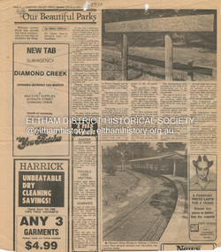
... with photograph and map. Photographs of Miniature Railway at former... Railway with photograph and map. Photographs of Miniature Railway ...Newspaper article: Our Beautiful Parks, Diamond Valley News, 8 March 1983, describing Eltham Lower Park and Diamond Valley Miniature Railway. Newspaper article: Diamond Valley News, 8 March 1983, Election of the ALP, Peter Stables member for Diamond Valley. Flier for Diamond Valley Miniature Railway with photograph and map. Photographs of Miniature Railway at former location at Chelsworth Park Ivanhoe. Newspaper article: New BBQ at Eltham Park, The Advertiser, 9 July 1996, about a joint project between Nillumbik Council and Eltham Rotary (On same page an article about the showcasing of indigineous plants around Nillumbik Shire offices at Civic Drive and on p4 an article about redevelopment works at Elis Cottage).main road, parks, miniature railway, chelsworth park ivanhoe, bbq facilities, civic drive, eltham lower park, eltham rotary, landscape, nillumbik shire council, ellis cottage, eltham (vic), chelsworth park, ivanhoe, diamond valley railway -
 Melbourne Tram Museum
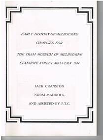
Document - Report, Jack Cranston, "Early History of Melbourne compiled for The Tram Museum of Melbourne - Stanhope St Malvern", c1990
... and electric tramways, railways, clubs, hospitals, hotels, maps, city... and electric tramways, railways, clubs, hospitals, hotels, maps, city ...Perfect bound, approx. 60 page document, clear plastic front cover, card rear cover, titled "Early History of Melbourne compiled for The Tram Museum of Melbourne - Stanhope St Malvern", prepared by Jack Cranston, Norm Maddock and assist by the PTC, undated, believed to be c 1990. Photocopied version with low quality B&W photos, extracts from Broadbents Melbourne Guide c 1912, with an index to Melbourne streets, cable, horse and electric tramways, railways, clubs, hospitals, hotels, maps, city sights. Includes notes on George Broadbent and his involvement with the RACV.trams, tramways, melbourne, maps, tramways, guides, cable trams, horse trams -
 Melbourne Tram Museum
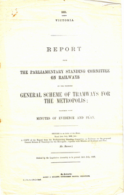
Map, Melbourne & Metropolitan Tramways Board (MMTB), Report - "Melbourne and Metropolitan Tramways Board General Scheme", May. 1923
... and views of the Railways Commissioners. .2 - Associated map... Parliament Brighton Railways Finances Map .1 - Printed document ....1 - Printed document - 1923 - Report - 8 pages - The Parliamentary Standing Committee on Railways - General Scheme for Tramways for Metropolis - printed 24/7/1923. Gives details of the committee, the committee report, comments on the Board's financial position, the debate between tramways or railways, recommendations and views of the Railways Commissioners. .2 - Associated map - Map - drawing with a line back, titled "Melbourne and Metropolitan Tramways Board Proposals for General Scheme". Shows the proposed tram lines submitted to Parliament for the report into the General Scheme. Printed by Sands & McDougall Pty Ltd. Signed by J. P Strickland dated 27-8-1923. .3 - as for .1, but in good condition - added 27-3-2018 from donation of Norm Cross.trams, tramways, mmtb, general scheme, tramways, development, parliament, brighton, railways, finances, map -
Clunes Museum
Document - MT BECKWORTH POST FFICE
... OF PART OF THE RAILWAY AND POSTAL & TELEGRAPH MAP OF VICTORIA... OF PART OF THE RAILWAY AND POSTAL & TELEGRAPH MAP OF VICTORIA MT ....1 MOUNT BECKWORTH (SOMETIMES SPELLED MOUNT BECKWITH) POST OFFICE WAS OPENED ON 1ST MARCH 1863 AS A RECEIVING OFFICE. IT WAS UPGRADED TO POST OFFICE ON 7TH JULY 1927 AND CLOSED ON 14 DECEMBER 1955/ BARRED NUMERAL CANCEL 431, OF WHICH TERE ARE VERY FEW KNOWN, WAS USED AT MOUNT BECKWORTH UNTIL CIRCULAR DATE STAMPS REPLACED THEM IN 1912 POST OFFICERS AT MOUNT BECKWORTH WERE J MCLEAN 1863-1864 THOMAS DUNN 1864-1909 B DUNN 1909-1911 R. DUNN 1911-1920 MISS CAMERON 1920-1936 MISS EVELYN CAMERON DUNN 1936-1939 BERTHA AMELIA DORIS ALSTON 1939 MRS. EVELYN CAMERON ROMEO 1939-1955 .2 LETTER FROM ALEX STONEMAN SENDING INFORMATIONS ABOUT THE HISTORY OF pOST OFFICES IN THE AREA, A PHOTOCOPY OF PART OF THE RAILWAY AND POSTAL & TELEGRAPH MAP OF VICTORIAmt beckworth post office, mount beckwith post office -
Glen Eira Historical Society
Article - OUTER CIRCLE RAILWAY
... images of various aspects of the railway and three line maps.... The document includes three maps of the outer circle railway line. 2 ...This file contains five items: 1/Two copies of a document titled THE OUTER CIRCLE RAILWAY by the Royal Historical Society of Victoria and the Australian Railway Historical Society, Vic div. It details the history of the construction of the Outer Circle Railway and discussed expenses and other factors affecting the construction of the line. Notes compiled by R.K Whitehead, Research and Archives Officer Australian Railway Historical Society Victoria Division. The document includes three maps of the outer circle railway line. 2/Four newspaper articles detailing the history of the Outer Circle Railway Line. They include ten black and white images of various aspects of the railway and three line maps. The first article is titled ‘Rail Link with the Past’. In the COLLINGWOOD COURIER dated 07/10/1970, author unknown. The second article titled ‘Ghost trains of the Outer’ by Kenneth Joachim in the HERALD dated 18/04/1975. The third article is titled ‘Tracks in Time’ by Norman Thompson from NEWS, dated 13/02/1973. The fourth article is titled ‘Our Ghost Railway’ by John Townsley from the HERALD, dated 06/11/1974. 3/A letter from Victorian Railways Chief Estate Officer N.A Wigmore to the Honorary Secretary of the Caulfield Historical Society, dated 19/11/1975 regarding the leasing of land along the Outer Circle Railway Reserve from Dandenong Road to the Hughesdale Station. 4/Two copies of an article titled ‘Outer Circle Railway’ in the CAULFIELD HISTORICAL SOCIETY NEWSLETTER undated detailing the history of the outer circle line. The article includes a map of the section of the line in Caulfield. 5/A Photocopy of two images of train line locations on the Outer Circle Line. One on Warrigal Road, looking south from Ashburton dated 1936. The second is of the Black Bridge over Gardiners Creek dated 1935.outer circle railway, normanby road, caulfield station, outer circle line, rosstown junction railway, monash john, caulfield historical society, poath road, deepdene dasher, ashby dasher, dandenong road, gippsy goods, mallee root mercury, outer circle railway reserve, railway lines, railway stations, steam trains -
 Eltham District Historical Society Inc
Photograph, Tess Justine (Nillumbik Shire Council), Murray's Bridge over the Diamond Creek, Eltham North, 19 Feb 2022
... until 1912 and the Victorian Railways maps at the time show... and the Victorian Railways maps at the time show no such siding on Murray’s ...Murray's Bridge over the Diamond Creek on the Diamond Creek Trail just prior to demolition and replacement with a new steel bridge. Heritage advice obtained by Nillumbik Shire Council, following a suggestion by the Eltham District Historical Society (EDHS), is that the original bridge appears to have been a simplified version of the Country Roads Board’s (CRB) standard timber bridge design of the early-to-mid 1920s. In c1990 Murray’s bridge was renovated with three recycled steel girders as part of a bike/pedestrian path in the reserve. During these alterations many parts of the bridge were removed, and some were replaced. Heritage advice indicates the condition of Murray’s bridge is poor. The remaining original parts are all in poor condition, with severe weathering, splitting and rot, especially to the stringers retained on the bridge. Heritage advice is that Murray’s Bridge does not have sufficient significance in the cultural history of the Nillumbik area to warrant inclusion in the Nillumbik Shire Heritage Overlay and also does not have sufficient significance as a rare survivor to warrant inclusion in the Nillumbik Shire Heritage Overlay. There are no indications in the historical record that this site was individually important to the cultural history of this area. EDHS is comfortable with the heritage advice provided to Council and has worked closely on this project with Council. EDHS has suggested some of the removed timbers be used in the vicinity of the bridge for landscaping and possibly seating, so as to retain these remnants close to the site of the original bridge, which is the last old timber bridge along the lower reaches of the Diamond Creek. Mary (Sweeney) Murray and John Wright Murray selected 80 acres, Lot C Section 16 and Lot 5 Section 17 Parish of Nillumbik, under an occupation license in 1866. John died in 1867 and freehold was granted to his son John in 1873. The farm was known as ‘Laurel Hill’. John Junior was an Eltham Shire councillor and sometime president from 1887 up until 1897. He added Lot A Section 16 to the farm in ca1888. John and his younger brother James arranged to rent/purchase Lot B Section 17, across Diamond Creek to the west, in ca1900. It appears that John and James farmed separately for a few years, with a new homestead built for James ad family on the high point of Lot B Section 17 in ca1910. John sold off Lot 5 Section 17 in 1912. When John died in 1912 James took over the land on both sides of the Diamond Creek. The old homestead on the west side of the Creek disappeared. A farm bridge over Diamond Creek from this period may have been located close to the northern boundary of the farm. John Langlands, owner of the farm known as ‘Ihurst’ on the west side of Diamond Creek to the south of the Murray’s land, died in 1907. In 1909 his land was then subdivided into 100 lots to become the ‘Glen Park Estate’. Other similar subdivisions of nineteenth century farms around Eltham in this period included the ‘Franktonia (or Beard’s) Estate’ to the northeast and ‘Bonsack’s Estate’ between Eltham and Greensborough. Soon after the opening of the railway extension line from Eltham to Hurstbridge in 1912, Glen Park and nearby residents including James Murray agitated for a railway station or siding to be located half-way between Eltham and Hurstbridge, so that the Glen Park residents who used the railway daily did not have to walk into the Eltham or Hurstbridge stations. Some believed Coleman’s Corner (opposite Edendale Farm) was an appropriate spot for the platform. James Murray was among those who thought the railway should be located on his land, closer to half-way between Eltham and Hurstbridge stations. The Railways Commissioners warned that the locals would have to fund these works themselves. The Glen Park Estate residents initially had difficulty accessing Eltham by road, with only an old low-level bridge over Diamond Creek at the south end of their estate. A new timber trestle bridge across the creek, now on Wattletree Road, was opened in 1915. Road access to the north was gained in 1927 when the new Murray’s Road, which crossed the Murray’s land, was built. Residents continued to agitate for a Glen Park station. By 1926 the Railways Commissioners’ preferred site was on the Murray’s land. They arranged an estimate of cost of a full-length platform. The estimate was too much for the locals, who in 1928 argued unsuccessfully for a shorter and hence cheaper platform. By 1929 Murray had agreed to donate the land, but the locals would still have to fund the works. Murray decided, unilaterally it would appear, to commence work on a timber trestle road bridge over Diamond Creek to link the new Murray Road to the proposed station. Late in 1929 he stopped work on the bridge, for reasons unknown, but started work again and completed the bridge in 1931. There is no further newspaper evidence of the campaign for the Glen Park station until 1939, when Murray and another local, Mr Maxwell, met the Railways Commissioner. The Glen Park locale now included 45 homes on the west side of the creek and 20 on the Eltham side. Most of the residents used the train every day. The Commissioner remained adamant that only a full-length platform could be built for safety reasons. It appears the campaign dissolved at this point. The increasing move to cars may have had an impact. There is no evidence of Murray’s bridge ever being connected to Murray’s Road, or of it having wide use for any purpose by locals. James Murray died in 1947 and the farm was taken over by his son James (Jim). Jim started to sell off parts of the farm in the 1980s, retaining a few acres around the ca1910 homestead and building a new house there. Recreation reserves were established along the creek. In ca1990 Murray’s bridge was renovated with steel girders as part of a bike/pedestrian path in the reserve. The old farmhouse was demolished in ca2014. * * * A theory posted on local community Facebook groups was that the bridge was built in the 1860s and was built to be more robust than was necessary for the movement of cows from one side of the creek to the other. It was suggested the robustness was necessary to support the weight of gold ore being transferred from a mine on Murray’s land to a railway siding near Murrays Bridge (presumably for transfer and processing at Diamond Creek). Perhaps this may have been one of the motivators for Murray, who really knows? Knowing when mining operations ceased on his land and how that fits the overall timeline would be useful but at the time the bridge was built, local gold production was minimal at best. The known facts are: • The railway line came to Eltham in 1902. • The extension of the railway from Eltham to Hurstbridge was constructed in 1912 so no railway line even existed through Murray's property until 1912 and the Victorian Railways maps at the time show no such siding on Murray’s property. • In 1923 a new company was formed in anticipation of the old Diamond Creek Gold Mine being re-opened. The mine had been previously closed and flooded. It was noted in the press at the time that the mine was within a mile of the railway. Nothing really came of this. • Construction of Murrays Bridge was commenced by James Murray in early 1929 in anticipation of a proposed flag station being nominated on his land, but work ceased shortly afterwards. The proposed flag station was commonly referred to as Glen Park as the residents of the Glen Park Estate wanted Option 1, located near them with the platform adjacent to Colemans corner. This was probably never going to fly as it was virtually in eyesight of Eltham station. Allandale Road was the third option, but the Commissioners' preferred option was No. 2 - on Murray's property. • The Railway Commissioners were not going to finance any such station and the works had to be funded by private landowners and residents, hence Murray investing in this himself. • Murray recommenced work two years later and finished his bridge in 1931 but unfortunately for him, the proposed flag station never eventuated. The bluestone siding you reference may well have been built by Murray as part of the proposed station platform. • Up until then, apart from the Main Road bridge, which was washed away in 1924, virtually all local crossings over the Diamond Creek were low lying bridges – Kaylocks Bridge at Brougham Street, Diamond Street bridge, Glen Park Road bridge. It is expected that Murray also had a low-lying bridge to connect his land either side of the creek. These were all washed away or severely damaged multiple times in the 1920s. Lessons were learnt, and Murrays Bridge appears to have been built in accordance with Country Road Board standards of the time. Flood damage was ongoing, and even more recently constructed raised bridges kept getting washed away, e.g., the new Wattle Tree Road bridge in 1958 just months after completion. Murray’s bridge was reinforced with steel some 30 years ago presumably to provide additional floodwater resistance, given the history of bridges disappearing in floodwaters. • In March 1932 it was reported in the Advertiser that there were still some prospectors operating around Eltham North who apart from further scarring the face of the earth over the previous two years had gained significant experience but little gold - hardly a driving factor for constructing a dedicated railway siding and bridge to transfer gold ore. It is far more probable that James Murray was hoping to have the railway station located on his property and invested his money by building the bridge to lead to it as well as a station platform. Had the station eventuated, it may well have driven up the value of his land for subdivision and new housing estates like the Glen Park Estate. That did not eventuate. Whilst the bridge was indeed old (90 years), the core structure being completed in 1931, it had been modified substantially from original and hence had no significant historic value – i.e., it was not a representative example of its type, construction, and age. Given that the bridge was not worthy of saving, the Eltham District Historical Society with Council’s support, and the Eltham Woodworkers group endeavoured to see what suitable sized timbers were salvageable to fabricate a commemorative seat. Unfortunately, the experts at the Woodworkers group were unable to salvage any suitable length/width timbers to fabricate the seat due to the presence of rot. Last remaining wooden trestle bridge on the Diamond Creek Trail just prior to demolition and replacementBorn digital image (27)diamond creek (creek), diamond creek trail, murrays bridge, ‘laurel hill’, john wright murray, mary (sweeney) murra, john murray jnr, james murray, john langlands, ‘ihurst’, ‘glen park estate’, beard's estate, franktonia, bonsack's estate, glen park estate, glen park railway station -
 City of Moorabbin Historical Society (Operating the Box Cottage Museum)
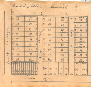
Plan - Grandview Estate
The train line from the city to Frankston was electrified in 1922 which intensified the sale in the municipality of Moorabbin, particularly land which was in the vicinity of the railway stations.The train line from the city to Frankston was electrified in 1922 which intensified the sale in the municipality of Moorabbin, particularly land which was in the vicinity of the railway stations. The Grandview Estate was auctioned on Saturday 10 November 1922.Example of the progress of the Municipality of MoorabbinHand drawn map of subdivision Grandview Estate, Bentleighcentre road, evelyn street (now wilson street), lily street, bentleigh, realestate, auction -
 Ballan Shire Historical Society
Map - Map. Kerrit Bareet, Department of Lands and Survey, Kerrit Bareet. County of Grant, 08/1944
A map of the Kerrit Bareet area within the County of Grant showing properties and names of owners in 1944.Significant to people researching land usage and ownership. Also those researching families in the area at that time.A map of Kerrit Bareet in the County of Grant. Black printing on buff coloured paper. Details roads, rivers, railways, property boundaries and names of property owners and towns and villages. The map is easily readable although there is some physical damage and that and the borders have been reinforced with sellotape. Shows a Scale in Chains and Price 2/.gordon, bungal, kerrit bareet, lal lal, moorarbool river, warrenheip, bungaree, wallace, moorarbool west -
 Ballan Shire Historical Society
Map - Map. Korweinguboora, Department of Lands and Survey, Korweinguboora. Counties of Talbot and Grant
A map of the Korweinguboora area showing roads, forests, railway lines and properties with the owners names.The inclusion of the names of landowners is of significance and value to historians.A map of the Korweinguboora area showing land subdivisions and names of owners and other physical features. There is a scale in chains. No date is certain but it could be 1902. The map has been repaired with sellotape.There are various pencil annotations but the are difficult to read.talbot, moorarbool west, wombat, bullarto, korweinguboora, moorarbool east, dean, wombat state forest, barkstead -
 Greensborough Historical Society
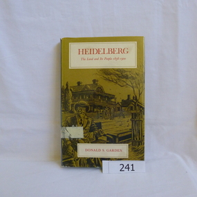
Book, Melbourne University Press, Heidelberg: the land and its people 1838-1900; by Donald P. Garden, 1838-1900
This book covers the early history of Heidelberg, Victoria from its beginnings in 1838 to 1900.There is some reference to the 'annexation' of Greensborough in 1875 and the route of the Heidelberg-Eltham railway line, 1893.Hard cover book. 218 p., ill., maps. Slip cover has a drawing based on an early photograph of the Old England Hotel.Property stamps from Nunawading Public Library (cancelled from their collection)heidelberg, greensborough, donald garden -
 Greensborough Historical Society
Map, Melbourne and Metropolitan Board of Works. Survey Division, MMBW, Yarra 2500 / 12.20. Watsonia Railway Station and environs, 1983_03
Melbourne and Metropolitan Board of Works. Yarra 2500 [base map]. 12-20, Parishes of Keelbundora 2856, Municipalities of Diamond Valley 257 and 228. Shows street names, easement sizes, lot numbers, lodged plan numbers, names of prominent features, contour values, creek or river names. Watsonia Railway Station and environs. Prominent streets: Watsonia Road, Elder Street, Morwell Avenue and Nepean Street. Includes former Watsonia Technical School and Gresswell Rehabilitation Centre sites.MMBW Map in 1:2500 [scale] series. Cream parchment with green tape reinforcing on edges and punched holes on left edge.mmbw, melbourne and metropolitan board of works, shire of diamond valley, watsonia - maps -
 Greensborough Historical Society
Map, Melbourne and Metropolitan Board of Works. Survey Division, MMBW, Yarra 2500 / 12.22. Watsonia North, 1978_03
Melbourne and Metropolitan Board of Works. Yarra 2500 [base map]. 12-22, Parishes of Keelbundora 2856, Municipalities of Whittlesea 239 and Diamond Valley 257. Shows street names, easement sizes, lot numbers, lodged plan numbers, names of prominent features, contour values, creek or river names. Watsonia Railway Station and environs. Prominent streets: Edmund Rice Parade and Macorna Street. Includes Christian Brothers Edmund Rice College and Janefield Special School sites and "proposed future freeway" (now Metropolitan Ring Road).MMBW Map in 1:2500 [scale] series. Cream parchment with green tape reinforcing on edges and punched holes on left edge.mmbw, melbourne and metropolitan board of works, shire of diamond valley, watsonia - maps, bundoora - maps -
 Greensborough Historical Society
Map, Melbourne and Metropolitan Board of Works. Survey Division, MMBW, Yarra 2500 / 12.21. Watsonia North, 1979_02
Melbourne and Metropolitan Board of Works. Yarra 2500 [base map]. 12-22, Parish of Keelbundora 2856, Municipality of Diamond Valley 257. Shows street names, easement sizes, lot numbers, lodged plan numbers, names of prominent features, contour values, creek or river names. Watsonia Railway Station and environs. Prominent streets: Grimshaw Street, William Street and Macorna Street. Includes former Institute of Social Welfare (now Loyola College) Lines Reserve and Binnak Park.MMBW Map in 1:2500 [scale] series. Cream parchment with green tape reinforcing on edges and punched holes on left edge.mmbw, melbourne and metropolitan board of works, shire of diamond valley, watsonia - maps, bundoora - maps -
 Greensborough Historical Society
Map, Melbourne and Metropolitan Board of Works. Survey Division, MMBW, Yarra 2500 / 12.24. Plenty and Blue Lake, 1977_10
Melbourne and Metropolitan Board of Works. Yarra 2500 [base map]. 12-24, Municipalities of Whittlesea 239 and Diamond Valley 257. Shows street names, easement sizes, lot numbers, lodged plan numbers, names of prominent features, contour values, creek or river names. Watsonia Railway Station and environs. Prominent streets: Memorial Drive. Includes Plenty River and Blue Lake in the Plenty Gorge.MMBW Map in 1:2500 [scale] series. Cream parchment with green tape reinforcing on edges and punched holes on left edge.mmbw, melbourne and metropolitan board of works, shire of diamond valley, plenty - maps, blue lake -
 Greensborough Historical Society
Map, Melbourne and Metropolitan Board of Works. Survey Division, MMBW, Yarra 2500 / 17.26. Hurstbridge, 1978_01
Melbourne and Metropolitan Board of Works. Yarra 2500 [base map] 17-26. Hurstbridge. Municipalities of Diamond Valley 257 and Eltham 238. Prominent streets include: Flat Rock Road and Heather Avenue. Includes Hurstbridge Railway Station.MMBW Map in 1:2500 [scale] series. Cream parchment with green tape reinforcing on edges and punched holes on left edge.mmbw, melbourne and metropolitan board of works, shire of diamond valley, hurstbridge - maps -
 Greensborough Historical Society
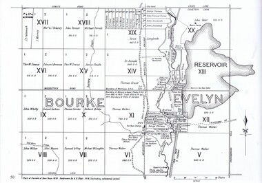
Map, Heidelberg: Historic River Landscape Assessment. Historical maps. Map E 1901-1934 "A Time of projects and improvements", 1985c
Geographical area of around 35 sq. kilometres marked with physical features such as major roads, railways (new extension to Eltham), rivers and properties, also housing sub-divisions and community facilities such as hospitals, parks and sporting reserves and indications of new small scale industries such as dairying. Bounded by Shire of Diamond Valley to the North, Darebin Creek to the West and Plenty River to the East. Black and white sketch map on white paperheidelberg, heidelberg - maps -
 Greensborough Historical Society
Map, Dianne Edwards, Part of Parish of Yan Yean 1878, 1978
Map includes Crown Portions V - XVII, showing Yan Yean Reservoir, Melbourne-Whittlesea Railway route, names of landowners, roads and various other features west of Greensborough Road. Redrawn by A. R. Blair in 1978.1 p. black and white photocopy of mapyan yean reservoir, yan yean -
![Work on paper - Newsletter, North East Link & Hurstbridge Railway Line: Community Update [Sept. 2020], 2020_09](https://victoriancollections.net.au/media/collectors/4f729f5697f83e03086015b8/items/6014eb092bef110c704f0fb5/item-media/6014eb9a2bef110c704f1691/item-fit-380x285.jpg) Greensborough Historical Society
Greensborough Historical SocietyWork on paper - Newsletter, North East Link & Hurstbridge Railway Line: Community Update [Sept. 2020], 2020_09
Banyule City Council comments on the North East Link & Hurstbridge Railway Line projects. This newsletter is to keep the community informed of developments and opportunities for consultation. Includes a sketch map of Watsonia from Grimshaw Street to Lower Plenty Road.4 page leaflet, colour text and images.north east link, hurstbridge rail line, banyule city council, watsonia -
Lorne Historical Society
Pamphlet - Tourist Brochure, Lovely Lorne
The Victorian Railways promoted tourist destinations around Victoria. A folded paper tourist brochure about Lorne The front cover is a coloured painting of Lorne from above the Erskine River towards the main beach. , on the back is a black and white sketch tourist map of the roads, tracks and beauty spots. Inside the first fold are 6 black and white photographs, Cumberland River, Mt St George, Phantom Falls, Cumberland Cliffs, Teddy’s Lookout, leafy walk towards the pier. Inside contains written descriptions of the highlights of Lorne and six black and white photographs, four general views of Lorne, Lover’s Walk, Erskine Falls . souvenirs, victorian railways, publicity -
Lorne Historical Society
Pamphlet - Tourist pamphlet Lorne, Lorne Victoria Australia
Victorian Railways printed a series of brochures publicizing holiday destinations.A folded paper souvenir pamphlet. The cover is a colored picture of Lorne from Scotsman’s Hill with two bathing suited young women in the foreground, and a blurb extolling the virtues of Lorne. On the back is a red, yellow and blue map of Lorne and district. Inside are eight black and white photographs of Lorne attractions,; the Main Street, tennis courts, Erskine River, walking tracks and the George River with the phrase ,” The resort that embraces everything for the perfect holiday.”souvenirs, pamphlets, victorian railways, -
 Greensborough Historical Society
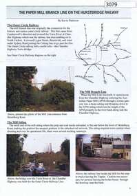
Article, Journal, Keith Patterson, The Paper Mill branch line on the Hurstbridge Railway, by Kevin Patterson, 2012_12
A branch line from the Outer Circle Line was built for the delivery of coal and paper pulp to the Australian Paper Mill at Fairfield. It operated as a branch from the Hurstbridge line until the 1970s, when the Australian Paper Mill plant changed to power by Bass Strait oil. 3 p., text , map and coloured photographs, pp. 4-6 of Nillumbik Custodian December (?) 2012husrstbridge railway line, outer circle railway line, australian paper mill -
 Greensborough Historical Society
Map, Greensborough Map with Rail Line Plan, 1970s
Central Greensborough area, including railway line and some landowners. Basic map made c. 1902; annotations dated to circa 1970sTwo copies of planParish of Keelbundora, County of Bourke. Central Greensborough areagreensborough, greensborough railway station -
 Federation University Historical Collection
Plan, City of Ballarat (Part) (Ballaarat East), 08/05/1928
Crown Cadastral Plan showing Governement Roads, Crown Parcels, Dimensions, Crown grantees, dated of grants, etc in Ballarat East. The plan shows features such as Bakery Hill, Canadian Station, recreation reserves, timber reserves, Yarrowee Creek, Black Hill Reserve, Eureka Reserve and Garden, Orphan Asylum, Rifle Butts Reserve, Ballarat Woollen Mill, Ballarat Observatory, Sovereign Hill Recreation Reserve, Specimen Vale, Market Reserve, Cemetery WGS 84 Centroid 37 degrees 33' 55" S 143 degrees 52' 38" E E.W. Extent; 5 km N-S Extent; 4 kmmap, plan, ballarat east, ballarat woollen mill, ballarat railway line, ballarat railway station, eureka reserve, eureka cemetery, ballarat orphanage, russell square, bakery hill -
 Federation University Historical Collection
Map, Ballaarat Gold Field, 1861, 21/10/1861
A party of surveyors camped by Yuille's Swamp (later Lake Wendouree) and surveyed the countryside for a map to be produced by the Geological Survey of Victoria. In November 2004 the Central Highlands Regional Library presented a special edition of 200 copies of the 1861 map reproduced from a copy in their collection. Original geological map of Ballarat showing property, waterways, mines, churches, schools, water races, and garden reserves. It was compiled and drawn from the surveys of Mining Surveyors Davidson, Fitzpatrick and Cowan.Compiled & Drawn from the Survey of Mining Surveyors Davidson, Fitzpatrick and Cowan & the Plans in the Surveyor General's Office by J. Brahe, 21st October 1861. R. Brough Smyth, Secretary for Mines. The Honourable J.B. Humffray, M.L.A. Commr of Mines.ballarat, map, davidson, robert brough-smyth, fitzpatrick, cowan, yuille's swamp, public garden reserve, manure depot, black hill, ballarat east, old post office hill, pennyweight hill, claytons hill, golden point, mining, railway, cricket ground, swamp creek, cemetery, sludge reserve, bakery hill, gaelic church, juvenile reformatory, orphanage, specimen hill, eureka lead, cattle yard hill, dalton's flat, chinese village, poverty hill, railway reserve, little bendigo diggings, pound reserve, allied armies, flour mill, agricultural reserve, marsh, survey reserve, survey corps, white flat, yarrowee, yarrowee creek, brache, j. brache, survey, ballaarat gold field 1861 -
 Federation University Historical Collection
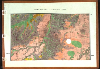
Map, Clunes, Mt Greenock, and Talbot Gold Fields, 1883
A geological plan of the Clunes, Mt Greenock, and Talbot Gold Fields in two parts. .1) This section of the map includes Talbot, Talbot water supply race, Mt Glasgow, Little Green Hill, Middle Hill, Mt Cameron, Ballarat Hill, Bakery Hill, Goodwoman Hill, Scandanavian Lead, Eglinton Swamp, McCallum's Creek, Tullaroop Creek, Dunach, Maryborough Railway, Middle Creek and includes many mines such as Rip Van Winkel, Union Extended, South Greenock, Nicholl's Freehold. .2) This section of the map includes McCallums, Clunes, Green Hill, Mt Beckworth, Mt Gap, Maryborough Reservoir, and includes mines such as Lothair, Bute, Clyde, Clunes Consols, London and Australian, Oriental,clunes, talbot, water supply, railway, geology -
 Federation University Historical Collection
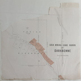
Plan, Goldmining Lease Blocks at Darkbonne, c1887
This map was originally inserteed into the Reports of Mining Registrars for the Quarter ender 30th June 1887.Paper plan showing Goldmining Lease Blocks at Darkbonne, north west of and near St Arnaud, on the Sunraysia Highway. darkbonne, st arnaud, new bendigo mine, alpha mine, working miners mine, chinese camp, donald/st arnaud railway, saint arnaud, darkbonne state school -
 Federation University Historical Collection
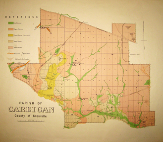
Map - Geological survey, Parish of Cardigan, County of Grenville, c1889
Geological map of the Parish of Cardigan on a cadastral base showing quartz reefs, shafts, alluvial deposits.cardigan, winter's creek, ballarat cattle yards railway, prince of wales park, ballarat, friendly societies reserve, ballarat industrial school reserve, green hill, bunker's hill, sago hill, diamond drill bores, cardigan propriety, half way house, ti tree creek, albion consols, prince imperial, winter's freehold company -
 Federation University Historical Collection
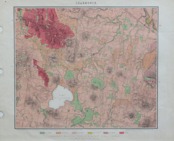
Map, Geological Map of Learmonth, 1882, 10/1882
Two copies: (printed noted attached) 3.) Rectangular geological map edged in masking tape. Six colours define geology and are predominantly pink. Scale 40 chains to one inch .4) Notes referring to the Geological Map of Learmonth learmonth, lake learmonth, glendaruel, burrumbeet, mt blowhard, morton's hill, mt bolan, addington, mt cavern, coghill's hill, mt hollowback, mt pisgah, weatherboard hill, webster's hill, foster's hill, mt bolen, one mile hill, vaughan's hill, tourello stattion, ballarat to maryborough railway, saddleback hill, ceres, brown's hill, ross's hill, norman taylor, robert burrows, richard shephard, james finnie