Showing 19 items matching "rainfall records"
-
 Kilmore Historical Society
Rainfall Records, Rainfall Records, Kilmore, 1902 - 1931, 1902 - 1931
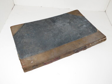
... Rainfall Records...Rainfall Records, Kilmore, 1902 - 1931...Rainfall records...Good condition. Rainfall Records, Kilmore, 1902 - 1931 Rainfall Records ...Four handwritten notebook, three black, one red. Red notebook has loose paper cover. The three black notebooks are worn. Good condition.rainfall records, kilmore east, westfield -
 Ringwood and District Historical Society
Envelope, Commonwealth Meteorology, Rainfall records kept by the Mile Family Ringwood (official record books). 1915-1958. History or Rainfall Observation at Ringwood 1969, 1915-1958
... Rainfall records kept by the Mile Family Ringwood (official record books). 1915-1958. ...Rainfall records kept by the Miles family; Three record books, rain register - Commonwealth Meteorology 1915-1925, 1937-1947, 1948-1958; History of Rainfall Observation at Ringwood: 13 February 1969; See also re rainfall collection 3466 2-3-3 Box 2; See also re rainfall collection 3993 2-7-05 Envelope +Additional Keywords: Temple Miles, A...Ringwood and District Historical Society 125A Warrandyte Road Ringwood North melbourne Rainfall records kept by the Miles family; Three record books, rain register - Commonwealth Meteorology 1915-1925, 1937-1947, 1948-1958; History of Rainfall Observation at Ringwood: 13 February 1969; See also re rainfall collection 3466 2-3-3 Box 2; See also re rainfall collection 3993 2-7-05 Envelope +Additional Keywords: Temple Miles, A Rainfall records kept by the Mile Family Ringwood (official record books). 1915-1958. ...Rainfall records kept by the Miles family; Three record books, rain register - Commonwealth Meteorology 1915-1925, 1937-1947, 1948-1958; History of Rainfall Observation at Ringwood: 13 February 1969; See also re rainfall collection 3466 2-3-3 Box 2; See also re rainfall collection 3993 2-7-05 Envelope +Additional Keywords: Temple Miles, A -
Southern Sherbrooke Historical Society Inc.
Document - Rainfall records - Belgrave South
... Rainfall records - Belgrave South...All rainfall is measured in points. Rainfall recorded by Helen Gibson. -Small notebook from Helen Gibson, which records the rainfall of Belgrave South (likely Mt Morton Rd) from January 1966 to December 1999. ...Rainfall in all these charts are measured in mm Document Rainfall records - Belgrave South ... -
Creswick Campus Historical Collection - University of Melbourne
Document, 1899-1990
... Rainfall records for Creswick, taken at School of Forestry 1899-1990. ...Rainfall records...These records are listed on Research Data Australia as a research set Rainfall records Document ...Rainfall records for Creswick, taken at School of Forestry 1899-1990. These records are listed on Research Data Australia as a research setRainfall records -
Tatura Irrigation & Wartime Camps Museum
Archive - Box - Archival, Post Office Records
... ...Rainfall records Tatura...Australian Post Code Book 1968. Rainfall records of Tatura 1923, 1943, 1987-1997. ...Australian Post Code Book 1968. Rainfall records of Tatura 1923, 1943, 1987-1997. ...Collection of Tatura Post Office records donated when the Post Office was sold to private enterprise in 2006. Commonwealth Bank Agency book - 1912 - 1921,1922-1926,1926-1935, 1935 - 1981, 1951-1971. Victorian Post Code Book 1987. Australian Post Code Book 1968. Rainfall records of Tatura 1923, 1943, 1987-1997. Folder No 128 Statistics - Office, TaturaBeige archival box containing documents pertaining to the Tatura Post Office before sold to private entity.tatura post office, documents, commnercial, australian post code book, rainfall records tatura, commonwealth bank agency book, victorian post codes -
Glenelg Shire Council Cultural Collection
Administrative record - Rainfall Chart - Coffey's Lane, Heywood 1975, c. 1975
... Heavy card, buff coloured, block grid lines, rainfall figures in blue biro, promoting Elders-GM. Rainfall recorded at Coffeys Lane, Heywood....Heavy card, buff coloured, block grid lines, rainfall figures in blue biro, promoting Elders-GM. Rainfall recorded at Coffeys Lane, Heywood. Administrative record Rainfall Chart - Coffey's Lane, Heywood 1975 ...Rainfall chart, single sided for 1975. Heavy card, buff coloured, block grid lines, rainfall figures in blue biro, promoting Elders-GM. Rainfall recorded at Coffeys Lane, Heywood. -
Ringwood and District Historical Society
Register, T. Miles, Ringwood Rainfall Register incl Rainfall reading 1959-1969. Also newspaper article on Quambee and the Miles recording rainfall, 1969, 1959 - 1969
... Used by J Miles to record the rainfall at Quambe between 1959 - 1969...Ringwood and District Historical Society 125A Warrandyte Road Ringwood North melbourne Used by J Miles to record the rainfall at Quambe between 1959 - 1969 'Rain Register' Commonwealth Meteorology Buff coloured register for recording rainfall. ...Used by J Miles to record the rainfall at Quambe between 1959 - 1969Buff coloured register for recording rainfall. Black printing on front. Instructions inside with 12 pages for recording rainfall and 13 loose pages. +Additional Keywords: Miles, J'Rain Register' Commonwealth Meteorology -
 Department of Energy, Environment and Climate Action
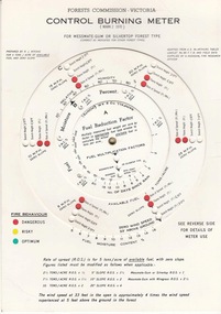
FCV Control burning meter, 1970
... By entering local rainfall records, the fuel load on the area to be burnt, wind speed at 33 feet above ground level and weather bureau estimates of temperature and relative humidity, the meter is used to indicate flame height, and the associated scorch height, that could be expected from lighting a grid of fires at regular intervals on level terrain - an allowance for slope variation was also possible....By entering local rainfall records, the fuel load on the area to be burnt, wind speed at 33 feet above ground level and weather bureau estimates of temperature and relative humidity, the meter is used to indicate flame height, and the associated scorch height, that could be expected from lighting a grid of fires at regular intervals on level terrain - an allowance for slope variation was also possible. ...The Forest Fire Danger Index (FFDI) was originally invented by the grandfather of Australian bushfire science, Alan Grant McArthur of the CSIRO, during the 1950s and ‘60s. Alan lit fires under various weather conditions and calculated their rates of spread under a range of fuel moisture conditions. He published his landmark paper, “Controlled burning in eucalypt forests” in 1962. Leaflet No. 80, as it was known, proved a turning point for forest and fire managers across Australia. More importantly, Alan was very practical forester and wanted his work to be useful to people in the field, so after several iterations he came up with the now familiar circular slide rule called the Forest Fire Danger Meter (FFDM). The Mk 4 version first appeared in operational use in 1967. Two Forests Commission staff, Athol Hodgson and Russ Ritchie, built on McArthur’s pioneering work and, by applying their own practical experience, developed a modified version in the late 1960s called the Control Burning Meter which was better suited to Victorian forest conditions. By entering local rainfall records, the fuel load on the area to be burnt, wind speed at 33 feet above ground level and weather bureau estimates of temperature and relative humidity, the meter is used to indicate flame height, and the associated scorch height, that could be expected from lighting a grid of fires at regular intervals on level terrain - an allowance for slope variation was also possible.Introduced to the FCV in 1970Control burning meterbushfire, forests commission victoria (fcv) -
 Warrnambool and District Historical Society Inc.
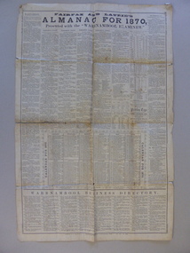
Document, News Sheet Almanac for 1870, 1870
... This Almanac records the many various organisations, such as churches schools councils and law related information.It lists public holidays, members of Parliament as well as births and deaths natural events such as rainfall, sunrise/sunsets and moon charts. it records mail charges and coach timetables.A middle section presents a calendar for 1870 with a record of events which were deemed important since the time of settlement It lists such things as the first telegram from Melbourne to Sydney1858, Governor Bligh deposed 1808, Burke and Wills funeral 1863. ...Warrnambool and District Historical Society Inc. 2 Gilles Street (south of Merri St) Warrnambool great-ocean-road This Almanac records the many various organisations, such as churches schools councils and law related information.It lists public holidays, members of Parliament as well as births and deaths natural events such as rainfall, sunrise/sunsets and moon charts. it records mail charges and coach timetables.A middle section presents a calendar for 1870 with a record of events which were deemed important since the time of settlement It lists such things as the first telegram from Melbourne to Sydney1858, Governor Bligh deposed 1808, Burke and Wills funeral 1863. ...This Almanac records the many various organisations, such as churches schools councils and law related information.It lists public holidays, members of Parliament as well as births and deaths natural events such as rainfall, sunrise/sunsets and moon charts. it records mail charges and coach timetables.A middle section presents a calendar for 1870 with a record of events which were deemed important since the time of settlement It lists such things as the first telegram from Melbourne to Sydney1858, Governor Bligh deposed 1808, Burke and Wills funeral 1863. At the bottom of the page is a Warrnambool Business Directory which includes J S Rowley Corio brewery, Royal Hotel , J H Rule Painter, plumber and glazier, J Brady , tinsmith and A Lanagan , Golden Boot The Warrnambool Examiner was founded by John Wilkinson and Richard Osburne in 1851. After a gap of a couple of years Richard Osburne resumed publication in October 1853 and continued until 1867. William Fairfax and Henry Laurie then leased the paper (1867 to 1872) before Richard Osburne again became the proprietor from October 1872 to April 1878 and from December 1879 to December 1880 when publication ceased. Fairfax and Laurie were the proprietors of the paper when this Almanac was published. William Fairfax was a member of the Fairfax family which was, and still is, associated with the publication of many Australian newspapers. Henry Laurie later became well-known as a Melbourne University Philosophy Professor.This single sheet of newspaper is an interesting and valuable record of Warrnambool and its people in 1870. There are names of many local people recorded and it also gives an insight into the variety of businesses and orhganisations which were established by 1870. It is also interesting to note that there are at least ten different styles of print on the page.Large single broadsheet of newspaper with large black heading and eight columns of print. The back of the page is blank.Fairfax and Laurie's Almanac for 1870 presented with the Warrnambool Examiner. Published as a supplement to the Warrnambool Examiner of 7th January 1870 Vol.XX No 1597.warrnambool, warrnambool almanac 1870,, examiner almanac warrnambool, fairfax and laurie, examiner warrnambool -
 Orbost & District Historical Society
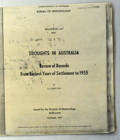
document, Bureau of Meteorology, DROUGHTS IN AUSTRALIA, 1957
... rainfall analyses. This document is a useful reference tool. drought-Victoria Foley-James-Charles Bureau-of-Meteorology climate Author J.C. Foley A 19 pp copy of a document titled DROUGHTS IN AUSTRALIA, Review of Records from Earliest Years of Settlement to 1955. ...Foley, J. C. (James Charles) (1892-1967) , classified major droughts in Australia from the early period of European settlement to 1955 on the basis of rainfall analyses. This document is a useful reference tool.A 19 pp copy of a document titled DROUGHTS IN AUSTRALIA, Review of Records from Earliest Years of Settlement to 1955. It was compiled by the Bureau of Meteorology in September,1957. This section deals mostly with droughts in Victoria.Author J.C. Foleydrought-victoria foley-james-charles bureau-of-meteorology climate -
 Flagstaff Hill Maritime Museum and Village
Journal - Record Book, Meteorological Observations, 1947-1948
... records on plain paper. There are calculations for monthly totals of information such as rainfall, and there are some comparisons between the years. ...records on plain paper. There are calculations for monthly totals of information such as rainfall, and there are some comparisons between the years. ...This bundel of twenty pages of meteorological observations covers the period between March 1947 and April 1948 but there are some gaps. The bundle includes handwritten records on pre-printed forms from the Commonwealth Government and brief records on plain paper. There are calculations for monthly totals of information such as rainfall, and there are some comparisons between the years. One of the forms has handwriting in three directions, which is quite unusual. Readings were recorded daily for barometer, temperature and wind. There was also a section for comments on Exceptional Phenomena such as storms and fog. . It was one of the many duties of the Lighthouse Keeper or his Assistant to keep these records and make the mathematical calculations required by the Government. Information gathered from Lighthouse Keepers' letters tells of the large amount of time taken for this detailed work and the lack of payment made for such a responsibility. The quite detailed record for May, June and July 1947 were signed by C Carrington, Harbour Master for Warrnambool. Captain Carrington was responsible to the Harborus Board. He was responsibilite for the fortnightly training of the Warrnambool Lifeboat Crew on the practice of lifesaving and using the Rocket Rescue equipment. These Meteorological Observations are an important accurate record of the local weather since the late 1899s. They are part of Flagstaff Hill's Meteorological Observations collection of over seventy record books dating from the late 19th century. The collected information gives a picture of the weather patterns for the months and seasons, which then allows for warnings of events out of the normal or extreme, such as forecasting floods or droughts.Meteorological Observations for Warrnambool March 1947 to May 1948. A bundle of unbound sheets of paper joined at the top left corner with a metal fastener. The pages are ordered from most recent on top to the oldest on bottom. The older records are on pre-printed forms and include many handwritten details. The more recent records are handwritten on plain paper. There is a line for each day of the month and lines for calculations at the bottom of the page. The handwritten Information includes readings for Barometer, Temperature, Wind and Rain. Printed: "COMMONWEALTH OF AUSTRALIA METEROLOGICAL OBSERVATIONS / Division No. 5, Vic. "flagstaff hill, warrnambool, great ocean road, shipwreck coast, flagstaff hill maritime museum and village, maritime museum, maritime village, meteorological observations, weather records, meteorology, barometer readings, temperature records, barometer records, wind records, rain records, commonwealth of australia, division 5, weather measurement, weather forecast, weather history, carrington, harbour master -
Glenelg Shire Council Cultural Collection
Administrative record - Rainfall Chart, c. 1974
... Heavy card, buff coloured, green grid lines, rainfall figures in blue biro; promoting Castrol fuels. Red 'Sibley Motors Pty Ltd HEYWOOD AND PORTLAND', on both sides. Administrative record ...Rainfall chart, double sided, 1974 one side, 1979 the other. Heavy card, buff coloured, green grid lines, rainfall figures in blue biro; promoting Castrol fuels. Red 'Sibley Motors Pty Ltd HEYWOOD AND PORTLAND', on both sides. -
 Federation University Historical Collection
Book, Records of Meterological Data for Ballarat 1892-1897, 1892 - 1897
... The column headings are: (AM) Date, Barometer, Ther. of Bar., Wet Bulb., Dry Bulb, Maxim., Minim, Rainfall, Wind, Remarks and State of Weather (PM) Date, Barometer, Ther. of Bar., Wet Bulb., Dry Bulb, Maxim., Minim, Rainfall, Wind, Remarks and State of Weather. Records of Meterological Data for Ballarat 1892-1897 Book Book ...A summary of meteorological data appears in the Ballarat School of Mines Annual Report for 1887 (P.35, 50). The last such summary appears in the Ballarat School of Mines Calendar 1901-2 (p58), which contains the data for the year 1900. No references have been found re names and job duties/positions of data collectors. The data was recorded by J. Matsen and A. Kiedahl.A charcoal grey hard covered, 120 page ledger, with brown leather spine and corners. The ledger has 31 special column heading, with the observed data added by hand. The column headings are: (AM) Date, Barometer, Ther. of Bar., Wet Bulb., Dry Bulb, Maxim., Minim, Rainfall, Wind, Remarks and State of Weather (PM) Date, Barometer, Ther. of Bar., Wet Bulb., Dry Bulb, Maxim., Minim, Rainfall, Wind, Remarks and State of Weather.Gold lettering on spine "Meteorological Observations: and on a glued on leather patch "School of Mines Ballarat" also in gold lettering. Written on inside front page: "Elevation of barometer 1420ft above Sea Level. To reduce barometric readings to Sea Level When Thermometer stands at 40 add 1.606 (to barometer) 45 " 1.590 50 " 1.574 55 " 1.559 60 " 1.543 65 " 1.528 70 " 1.528 80 " 1.499 85 " 1.471 90 " 1.457 95 " 1.444 100 " 1.431 Lightly hand written in pencil on the next page: "J. Matsen Feb 1891 to Feb 1894 - 3 years A. Kildahl Feb 1894 - " A circle has been place around the hottest temperature for the month. ballarat school of mines, smb, meteorology, j. matsen, a. kiedahl, kiedahl, matsen, rain, weather, meteorological data -
University of Melbourne, Burnley Campus Archives
Document, Burnley Weather Records, 1951-1980
... University of Melbourne, Burnley Campus Archives 500 Yarra Boulevard Richmond melbourne rainfall charts observations burnley weather records Rainfall charts, observations, notes, correspondence Burnley Weather Records Document ...Rainfall charts, observations, notes, correspondencerainfall charts, observations, burnley, weather records -
University of Melbourne, Burnley Campus Archives
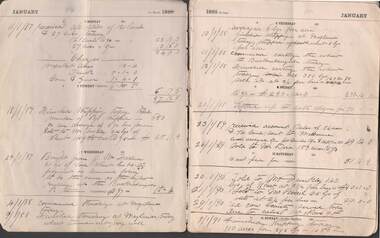
Book - Register, Rainfall Registration, 1951-1983
... Rainfall registration charts in a variety of forms recorded at Burnley. (1) 1 page handdrawn on cardboard, monthly and annual totals 1951-1978 (part). (2) 1974-1978 daily. (3) Unused forms. (4) 1980-1983. (5) Climatological Data for Melbourne up to 31st December 1964. ...Found in a folder labelled, "Burnley Weather Records." Rainfall Registration Book Register ...Rainfall registration charts in a variety of forms recorded at Burnley. (1) 1 page handdrawn on cardboard, monthly and annual totals 1951-1978 (part). (2) 1974-1978 daily. (3) Unused forms. (4) 1980-1983. (5) Climatological Data for Melbourne up to 31st December 1964. Found in a folder labelled, "Burnley Weather Records." rainfall registration, weather reports, climatological data -
 Whitehorse Historical Society Inc.
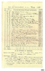
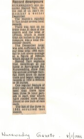
Article, Record downpours, 8/01/1986 12:00:00 AM
... Whitehorse Historical Society Inc. 2-10 Deep Creek Road Mitcham melbourne rainfall tarr harold springvale road nunawading Record downpours in Nunawading area, December 1985. ...Record downpours in Nunawading area, December 1985.Article on record downpours in Nunawading area, December 1985.Record downpours in Nunawading area, December 1985.rainfall, tarr, harold, springvale road, nunawading -
 Bendigo Historical Society Inc.
Document - FARM DIARY
... Record segments date from period 1886-1894. Temperature, rainfall, farm-life both domestic and agricultural recorded. ...Record segments date from period 1886-1894. Temperature, rainfall, farm-life both domestic and agricultural recorded. ...Portion of loosely -bound thirty-four double sided cream coloured page farm diary anonymous donor received 2011. Charlton, Barrakee, Buckrabanyule districts. Record segments date from period 1886-1894. Temperature, rainfall, farm-life both domestic and agricultural recorded. Prices of animal stock, grain and machinery. Property names mentioned include New Guinea, Maylands, The diary begins on 4.1.1886 on 10.2.1886 he was sworn in as one of Her Majesties Volunteers to serve for a period of three years , gave a cheque for three pounds 13 shillings for the purchase of a new rifle 27.2.1886 'Received my new rifle today with bayonet , belt and pouch , No 9153 . 17.5.1886 entry states he went to the Presbyterian team meeting at Charlton and enjoyed himself very muchheritage, charlton, farming -
 Sunshine and District Historical Society Incorporated
Document - Maribyrnong River The 2022 Flood Event In Victoria Reports, Parliament of Victoria, 2024
... recorded flood level: 4.50 m at the Chifley Drive gauge. This remains the benchmark flood for the Maribyrnong catchment. This flood washed away the Arundel Road Keilor timber bridge during its construction. 1916 – Early 20th‑century flood - Less documented than 1906 but included in the official count of major events. Occurred during a period of widespread Victorian flooding. 1934 – The Great Melbourne Flood - Part of the catastrophic 1934 state‑wide floods. Maribyrnong catchment experienced severe riverine overflow. This event reshaped early flood‑mitigation thinking across Melbourne. 1974 – Widespread metropolitan flooding - Heavy rainfall...recorded flood level: 4.50 m at the Chifley Drive gauge. This remains the benchmark flood for the Maribyrnong catchment. This flood washed away the Arundel Road Keilor timber bridge during its construction. 1916 – Early 20th‑century flood - Less documented than 1906 but included in the official count of major events. Occurred during a period of widespread Victorian flooding. 1934 – The Great Melbourne Flood - Part of the catastrophic 1934 state‑wide floods. Maribyrnong catchment experienced severe riverine overflow. This event reshaped early flood‑mitigation thinking across Melbourne. 1974 – Widespread metropolitan flooding - Heavy rainfall ...The Maribyrnong River flows through the former Shire of Keilor, Shire of Braybrook and the City of Sunshine and now the City of Brimbank. The river has a long history of flooding including the following events; 1906 – The largest flood on record - Highest recorded flood level: 4.50 m at the Chifley Drive gauge. This remains the benchmark flood for the Maribyrnong catchment. This flood washed away the Arundel Road Keilor timber bridge during its construction. 1916 – Early 20th‑century flood - Less documented than 1906 but included in the official count of major events. Occurred during a period of widespread Victorian flooding. 1934 – The Great Melbourne Flood - Part of the catastrophic 1934 state‑wide floods. Maribyrnong catchment experienced severe riverine overflow. This event reshaped early flood‑mitigation thinking across Melbourne. 1974 – Widespread metropolitan flooding - Heavy rainfall across Melbourne caused significant rises in the Maribyrnong. Often referenced in Melbourne Water’s long‑term flood modelling. 1983 – Ash Wednesday period flooding - Occurred during the same climatic cycle as the Ash Wednesday bushfires. Intense rainfall caused rapid rises in the Maribyrnong River. 2011 – La Niña flood cycle - Part of the broader 2010–2011 La Niña flooding across Victoria. Maribyrnong experienced moderate–major riverine flooding. 2022 – The most significant modern flood - One of the worst urban floods in Melbourne in decades. Hundreds of homes inundated; major damage in Maribyrnong, Kensington, Ascot Vale. Triggered a parliamentary inquiry, major insurance issues, and debate over the Flemington Racecourse floodwall. Officially counted as the seventh major flood since 1906.The Maribyrnong River 2022 flood was one of the most significant urban flood events in Melbourne in decades. On 14 October 2022, after days of record‑breaking rain across Victoria, the Maribyrnong River breached its banks, inundating large parts of Keilor, Braybrook, Maribyrnong, Kensington, Ascot Vale, and surrounding suburbs. Many houses and streets in Maribyrnong were flooded by the river including the Angler’s Tavern, Anglers Way, Maribyrnong which was inundated up to the second floor. The flood also damaged many upstream locations including the flat lands of the Maribyrnong Valley, Brimbank Park and washing away part of the historical Arundel Road timber bridge in Keilor, the second time in its 116 year old history.maribyrnong river, flood, angler’s tavern, anglers way, maribyrnong, arundel road bridge, keilor -
 Department of Energy, Environment and Climate Action
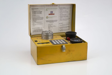
Prototype fuel moisture meter
... Some mathematical models rely on weather records such as rainfall, wind speed, evaporation, cloud cover, shading, relative humidity, slope, aspect and season of the year to predict soil and fuel moisture. ...Some mathematical models rely on weather records such as rainfall, wind speed, evaporation, cloud cover, shading, relative humidity, slope, aspect and season of the year to predict soil and fuel moisture. ...Bushfire behaviour is influenced by many things including temperature, relative humidity, forest type, fuel quantity and fuel dryness, topography and even slope. Wind has a dominant effect on the Rate of Spread (ROS), and also bushfire size, shape and direction. Fuel arrangement is as important as fuel quantity (tonnes/ha). Fibrous and ribbon bark, together with elevated and near-surface scrub fuels act as ladders which lead flames into the tree canopy. But the availability of fuel to burn depends largely on its moisture content. When it exceeds 20-25% not much will burn, whereas 12-15% is generally ideal for fuel reduction burning, but if the moisture content drops as low as 7-10% virtually everything will ignite, and fire behaviour becomes extreme. During the afternoon of the Ash Wednesday bushfires on 16 February 1983 fuel moisture contents were recorded at Stawell as low as 2.7%. Fine fuels like leaves and bark can rapidly absorb moisture after a shower of rain, or from the air when the Relative Humidity (RH) is high, and the temperature is low. Conversely, they can also dry out very quickly. So even though the overall fuel quantity in the forest doesn’t change, the fine fuel availability can increase rapidly from zero after rain to many tonnes per hectare as the fuel dries out. This can happen over a few hours on hot and windy days. Heavy fuels like logs on the ground take longer to dry out. Since the 1930s foresters, firefighters and researchers have been working to develop quick and reliable techniques for measuring fuel moisture content. One of the most accurate methods is slowly drying a sample of fuel in a conventional oven for 24-48 hours to remove all the moisture and measuring the weight difference, but this takes time and is not practical in the field when rapid measurements are needed. But oven drying is often used as a benchmark to compare other methods. Microwave ovens are faster but can cause uneven drying and even char the fuel. They are also not very practical for use in the field. Some mathematical models rely on weather records such as rainfall, wind speed, evaporation, cloud cover, shading, relative humidity, slope, aspect and season of the year to predict soil and fuel moisture. The Keetch-Byram Drought Index of soil dryness is the most common. But complex fuels with leaves, twigs, grass etc make the predictive models often inadequate for fine fuels. The most common technique in Victorian forests until recently was the trusty Speedy Moisture Meter. Originally developed in England during the 1920s for measuring moisture in wheat and other grains it was adapted for Australian forest fuels in the 1950s (I think). Fuel was first ground using a Spong mincer, often attached to the bullbar of a vehicle, and a small sample placed into the Speedy together with a measure of calcium carbide and then sealed. A chemical reaction created gas pressure which was read on the external dial. There were important techniques with cleaning, mincing and using the chemicals with the Speedy to give reliable readings, but it was quick, inexpensive, robust, portable and practical in the field. It was used routinely before igniting a fuel reduction burn or measuring fuel moisture differentials on slash burns. But in about 1996, Karen Chatto and Kevin Tolhurst from the Department’s Creswick Research Station developed the Wiltronics Fuel Moisture meter which measured electrical resistance. Wiltronics is an Australian owned company operating from Ballarat. The final result was a kit that was portable, accurate and could reliably measure fuel moisture contents between 3% and 200%. Although expensive, it is now widely used by fire agencies around the world which has virtually relegated the Speedy to the back cupboard.Prototype Fuel moisture meterT-H Fine Fuel Meterforests commission victoria (fcv), bushfire, forest measurement