Showing 43 items matching "relief map"
-
 National Vietnam Veterans Museum (NVVM)
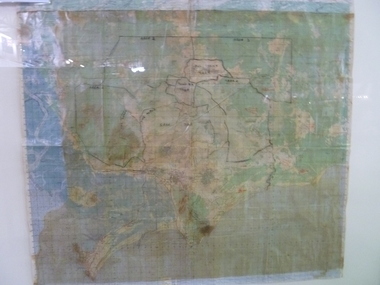
Map, Relief Map of Vietnam
... Relief Map of Vietnam...Relief Map...Detailed relief map with words XA BIN BA + XUYEN MOC titled on information heading. ...National Vietnam Veterans Museum (NVVM) 25 Veterans Drive Newhaven phillip-island-and-the-bass-coast Relief Map Vietnam Detailed relief map with words XA BIN BA + XUYEN MOC titled on information heading. ...Detailed relief map with words XA BIN BA + XUYEN MOC titled on information heading. Map information listed on lower portion.relief map, vietnam -
 National Vietnam Veterans Museum (NVVM)
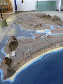
Map - Map, Relief, PHU
... Map, Relief...Relief Map...Raised relief map of Phuoc Tuy province. Six pieces showing land features from Long Hai hills to coast at Vung Tau base...National Vietnam Veterans Museum (NVVM) 25 Veterans Drive Newhaven phillip-island-and-the-bass-coast Relief Map Phuoc Tuy Raised relief map of Phuoc Tuy province. ...Raised relief map of Phuoc Tuy province. Six pieces showing land features from Long Hai hills to coast at Vung Tau baserelief map, phuoc tuy -
 National Vietnam Veterans Museum (NVVM)
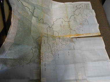
Map, Relief Map
... Relief Map...Scale 1:250,000 Relief Map Map Map ...Large scale map of Vietnam showing marked bounaries of provinces. Scale 1:250,000Series L500 Sheet NE 49-13 Edition 3-AMSmap, aattv -
 Vision Australia
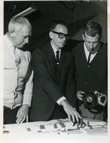
Photograph - Image, Using a 3D map of Sydney
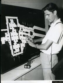
... A blind man feels model buildings on a relief map of the Sydney CBD whilst two others look on. ...B/W photograph of blind man using relief map...Vision Australia 454 Glenferrie Road Kooyong melbourne A blind man feels model buildings on a relief map of the Sydney CBD whilst two others look on. ...A blind man feels model buildings on a relief map of the Sydney CBD whilst two others look on. B/W photograph of blind man using relief mapLearning layout of City of Sydney by raised map Orientation - historical RBS XIroyal blind society of nsw, maps -
 Vision Australia
Photograph - Image, Ron Goodwin reading a map of Wynyard train station, 1969?
... B/W photograph of man looking at relief map of Wynyard Station...Report Orientation - historical B/W photograph of man looking at relief map of Wynyard Station Ron Goodwin reading a map of Wynyard train station Photograph Image ...Ron Goodwin reads a tactile map of Wynyard Railway Station in Sydney's CBD. The map was made at the Sydney Tesol College with wood working machinery and painting/decorating sections. In front of Ron sits a ultrasonic torch.B/W photograph of man looking at relief map of Wynyard Station14/69051 Ann. Report Orientation - historicalroyal blind society of nsw, ron goodwin, maps -
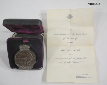
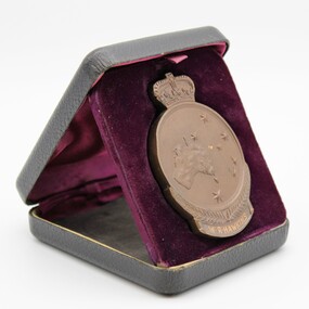
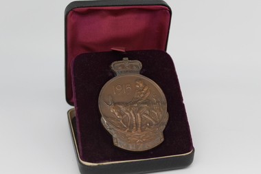
 Kyneton RSL Sub Branch
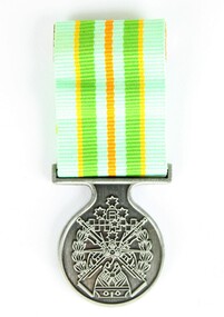
Medallion, ANZAC Commemorative Medallion, 1967
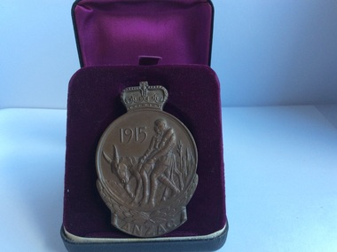
... Front: 1915 ANZAC Two soldiers on a donkey.. Back: Relief map of Australia and New Zealand. and five stars of the Southern Cross. ...It was awarded to surviving members ( or next of kin) of the Australian Forces who served on the Gallipoli Peninsular from April 1915 - Jan 1916. anzac gallipoli commemorative medallion Front: 1915 ANZAC Two soldiers on a donkey.. Back: Relief map of Australia and New Zealand. and five stars of the Southern Cross. ...The Anzac Commemorative Medallion was issued in 1967. It was awarded to surviving members ( or next of kin) of the Australian Forces who served on the Gallipoli Peninsular from April 1915 - Jan 1916.Round medallion with crown on top. Impressions both sides. Is contained in a black case lined with purple fabric.Front: 1915 ANZAC Two soldiers on a donkey.. Back: Relief map of Australia and New Zealand. and five stars of the Southern Cross. F.J. Roberts.anzac, gallipoli, commemorative medallion -
 Ringwood and District Historical Society
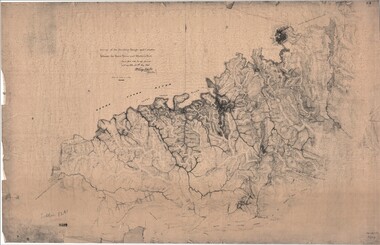
Map, Survey of Dividing Range between Yarra Yarra and Western Port - William Wedge Darke, 1843
... Surveyor's relief map of features to the east of Melbourne including Yarra Yarra River, Mullum Mullum Creek, Anderson's Creek, Dandenong Creek....Several huts also marked. Surveyor's relief map of features to the east of Melbourne including Yarra Yarra River, Mullum Mullum Creek, Anderson's Creek, Dandenong Creek. ...Extract - Ringwood, Place of Many Eagles - Hugh Anderson (1974): William Wedge Darke, from Hereford, England, was a nephew of John Helder Wedge of the Port Phillip Association, who was also a surveyor. William's most important work was probably his survey of the Dividing Range and the country between the Yarra River and Western Port, completed in May 1843, and during which he made a traverse between the Mullum and Dandenong creeks along the higher ground that he labelled the "best line of road from Melbourne". This road was for many years the major route to Gippsland and to the higher country about Alexandra and Mansfield, sometimes known as White Horse Road, and now Maroondah Highway.Surveyor's relief map of features to the east of Melbourne including Yarra Yarra River, Mullum Mullum Creek, Anderson's Creek, Dandenong Creek.Transmitted to the Surveyor General with my letter of 10th May 1843 (signed) Wm Wedge Drake, Assistant Surveyor. Scale: two inches to a mile. Descriptive remarks include upstream area of Yarra River - "impassable, appears to have been formerly a lake", and to the south - "barren and scrubby swamps of the Western Port Country". Marked tracks include "best line of road from Melbourne", "track to Dandenong", "Road to Port Albert may probably be found on this range", "Best line to Upper Yarra". Several huts also marked. -
 Vision Australia
Photograph - Image, Jack Chamberlain reading a tactile map of Sydney with Val Hickey, 1970?
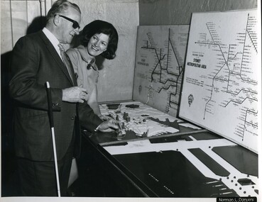
... Jack Chamberlain (P.R.O.) feeling a relief map of Sydney's CBD, with Val Hickey (Publicity Officer)....Vision Australia 454 Glenferrie Road Kooyong melbourne Jack Chamberlain (P.R.O.) feeling a relief map of Sydney's CBD, with Val Hickey (Publicity Officer). ...Jack Chamberlain (P.R.O.) feeling a relief map of Sydney's CBD, with Val Hickey (Publicity Officer).2 x B/W photographs of man looking at transit map4/70414 and 6/70414royal blind society of nsw, jack chamberlain, val hickey, maps -
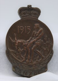
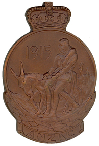
 Bendigo Military Museum
Memorabilia - ANZAC COMMEMORATIVE MEDALLION, Government of the Commonwealth of Australia, Unknown
... Reverse features a Queen's Crown on top with a wreath and plaque at bottom. Centre has a relief map of Australia and New Zealand with the Southern Cross. ...Reverse features a Queen's Crown on top with a wreath and plaque at bottom. Centre has a relief map of Australia and New Zealand with the Southern Cross. ...Anzac Commemorative medallion in case with certificate presented to R.R. O'Donahoo to mark the 50th Anniversary of the Gallipoli landing. Part of the O'Donahoo Collection. See Cat No. 10928.3 for details of service for "Robert Raymond O'Donahoo" S/N 1399.1. Circular bronze medal with Queen's Crown on top. Obverse features Simpson and his donkey carrying a wounded soldier. Laurel wreath below with plaque bearing the word ANZAC, 1915 above donkey. Reverse features a Queen's Crown on top with a wreath and plaque at bottom. Centre has a relief map of Australia and New Zealand with the Southern Cross. Recipients name engraved on plaque. 2. Black leatherette, covered, hinged box with purple coloured lining. Medal sits on spring loaded pad with indentation to house it. 3. Cream coloured certificate with details in black type. Australian Coat of Arms at top. 1. Engraved on plaque on reverse: "R.R. O'DONAHOO"o'donahoo collection, robert raymond o'donahoo, anzac medallion, gallipoli, ww1 -
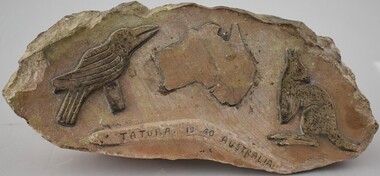 Tatura Irrigation & Wartime Camps Museum
Plaque, 1940s
... Bas relief stone carving. A map of Australia, flanked by a kangaroo, boomerang and a kookaburra and "Tatura 1940 Australia" on the boomerang...Tatura Irrigation & Wartime Camps Museum 49 Hogan Street Tatura the-murray Carved by German POW at Camp 13 civic mementos - plaques internee stone carvings Tatura 1940 Australia Bas relief stone carving. A map of Australia, flanked by a kangaroo, boomerang and a kookaburra and "Tatura 1940 Australia" on the boomerang Plaque Plaque ...Carved by German POW at Camp 13Bas relief stone carving. A map of Australia, flanked by a kangaroo, boomerang and a kookaburra and "Tatura 1940 Australia" on the boomerangTatura 1940 Australiacivic mementos - plaques, internee stone carvings -
 Beechworth RSL Sub-Branch
Anzac Commemorative Medallion
... The reverse shows a map in relief of Australia and New Zealand superimposed by the Southern Cross. ...The reverse shows a map in relief of Australia and New Zealand superimposed by the Southern Cross. ...The reverse shows a map in relief of Australia and New Zealand superimposed by the Southern Cross. ...The Anzac Commemorative Medallion was instituted 1967. It was awarded to surviving members of the Australian forces who served on the Gallipoli Peninsula, or in direct support of the operations from close off shore, at any time during the period from the first Anzac Day in April 1915 to the date of final evacuation in January 1916. Next of kin, or other entitled persons, are entitled to receive the medallion on behalf of their relatives if the medallion has not been issued. Design The medallion is cast in bronze and is approximately 75 millimetres high and 50 millimetres wide. The obverse of the medallion depicts Simpson and his donkey carrying a wounded soldier to safety. It is bordered on the lower half by a laurel wreath above the word ANZAC. The reverse shows a map in relief of Australia and New Zealand superimposed by the Southern Cross. The lower half is bordered by New Zealand fern leaves. The name and initials of the recipient is engraved on the reverse. The medallion is issued in a presentation box. Badge Surviving members were also issued with a lapel badge in the form of a small replica of the medallion to recognise their Gallipoli service. This badge is not issued to other applicants.This medallion was presented to A. F. Hoffman a survivor of the Gallipoli Campaign. The medallion is cast in bronze and is approximately 75 millimeters high and 50 millimeters wide. The obverse of the medallion depicts Simpson and his donkey carrying a wounded soldier to safety. It is bordered on the lower half by a laurel wreath above the word ANZAC. The reverse shows a map in relief of Australia and New Zealand superimposed by the Southern Cross. The lower half is bordered by New Zealand fern leaves. The name and initials of the recipient is engraved on the reverse. The medallion is in the original presentation box that show wear from handling and ageThe recipients name is inscribed A.F. Hoffmanmedallion, anzac medellion, boxed medallion -
 Geelong RSL Sub Branch
Medallion, Department of Defence, Mid 20th Century
... The reverse shows a map in relief of Australia and New Zealand superimposed by the Southern Cross. ...The reverse shows a map in relief of Australia and New Zealand superimposed by the Southern Cross. ...ANZAC Commemorative Medallion is issued to all members of the Australian Defence Force and New Zealand Defence Force who served on the Gallipoli Peninsula. The medallion is also known as the Gallipoli Medallion.The personnel receiving the medallion served on the Gallipoli Peninsula from 25 April 1915 to the final date of evacuation in January 1916.The medallion is round the obverse depicts Simpson and his donkey carrying a wounded soldier to safety. It is bordered on the lower half by a laurel wreath above the word ANZAC. The reverse shows a map in relief of Australia and New Zealand superimposed by the Southern Cross. The lower half will be boardered by the New Zealand Fern Leaves. There is a crown at the top of the medallion. The medallion is cast in bronze.This medallion has the name W.E. Sabeston inscribed on the back underneath the New Zealand Fern Leaves.anzac, medallioin, gallipoli, 1915-1916, defence. -
 Montmorency–Eltham RSL Sub Branch
Medal - Commemorative Medallion, Issues began 1967
... The reverse shows a map in relief of Australia and New Zealand superimposed by the Southern Cross. ...The reverse shows a map in relief of Australia and New Zealand superimposed by the Southern Cross. ...Medallion awarded to surviving members of Australian forces who served on the Gallipoli Peninsula during 25 April 1915 to January 1916. Recipient enlisted 07 June 1915 and was taken on strength of the 4th Australian Light Horse Regiment at ANZAC on 14 October 1915. He arrived at Alxandria on 27 December 1915. Subsequently served in France, and was discharged, in London, 24 January 1920. Returned to Australia, departing United Kingdom 06 May 1921. Cast bronze, approximately 75 mm high and 50mm wide. The obverse depicts Simpson and his donkey carrying a wounded soldier, with '1915' . It is bordered on the lower half by a laurel wreath above the word ANZAC. The reverse shows a map in relief of Australia and New Zealand superimposed by the Southern Cross. The lower half is bordered by fern leaves. The name and initials of the recipient is engraved on the reverse. The presentation box in black leatherette is lined with deep red velvet and deep red silk (lid)."W. R' Hawkins" -
 Federation University Historical Collection
Medal - Numismatics, ANZAC Commemorative Medal for R.M. Serjeant, 1967
... The reverse (the back) shows a relief map of Australian and New Zealand superimposed by the Southern Cross. ...The reverse (the back) shows a relief map of Australian and New Zealand superimposed by the Southern Cross. ...Robert M. Serjeant was the only son of Theo and Alice Serjeant, and grandson of famed mine manager Robert Malachy Serjeant (1829-1902). Robert Serjeant was a past student of the Ballarat School of Mines (SMB), and at the time of his World War One enlistment he had just finished an electrical course, and was working as a junior member of the SMB Department of Electricity. Robert Serjeant enlisted in December 1914. Corporal Serjeant (2138) of the 8th Battalion, died of wounds received in action at Gallipoli on 28 April 1915, aged 20. He was buried at sea and his name is listed at the Lone Pine Memorial. A brown paper parcel of Robert Serjeant's belongings was returned to his parents. It contained his discs, wrist-watch (damaged), notebook, hymn book and letters. [1] The Ballarat Courier reported: 'He was of quiet disposition, and a great student, devoting himself closely to his work.' Further information on R.M. Serjeant can be found at https://bih.federation.edu.au/index.php/Robert_M._Serjeant_Jnr The following statement on the ANZAC Commemorative Medallion and Badge was made by by Prime Minister Holt in 16 March 1967 when the Minister for Defence announced that it had been decided by the Australian Government, in consultation with the New Zealand Government, to issue a medallion and lapel badge to the veterans of the Gallipoli Campaign. "Last March, the Minister for Defence announced that it had been decided by the Australian Government, in consultation with the New Zealand Government, to issue a medallion and lapel badge to the veterans of the Gallipoli Campaign. I am glad to be able to announce that arrangements have now been completed for the production of the medallion and the badge. The Minister for the Army will be arranging distribution to those wishing to receive them as soon as possible. The Government hopes that production of the medallion and lapel badge will be sufficiently advanced to permit at least some of them to be distributed by ANZAC Day. The medallion (with the name of the recipient inscribed) will be issued to the surviving members of the Australian Defence Force who served on the Gallipoli Peninsula, or in direct support of the operations from close off-shore, at any time during the period from the first ANZAC Day in April, 1915 to the date of final evacuation in January, 1916. Next of kin or other entitled persons will be entitled to receive the medallion on behalf of their relatives, if the relative died on active service or has since died. For surviving members, a lapel badge will also be available for wearing. This will be a replica of the obverse (or front) of the medallion and will be about 1 inch high and 2/3 inch wide - the same size as the RSL badge. The medallion is the work of Mr. Raymond Ewers, the well-known Australian artist, based on a suggestion by Mr. Eric Garrett, a staff artist with the Department of the Army. It has been endorsed by both the Government of New Zealand and ourselves. It will be approximately 3 inches high and 2 inches wide. The obverse of the medallion depicts Simpson and his donkey carrying a wounded soldier to safety. It will be bordered on the lower half by a laurel wreath above the word ANZAC. The reverse (the back) shows a relief map of Australian and New Zealand superimposed by the Southern Cross. The lower half will be bordered by New Zealand fern leaves. The medallion will be cast in bronze and the lapel badge will be metal of a bronze colour. For the information of the honourable members I present also a brief statement setting out the conditions of eligibility which will apply to the medallion and badge and the manner in which those desiring to receive them should apply."(https://www.awm.gov.au/encyclopedia/anzac/medallion/doc.asp, accessed 26/02/2014) Conditions of eligibility. All members of the Australian Defence Force who served during the Gallipoli Campaign are entitled to receive the ANZAC Commemorative medallion. The campaign lasted from April 25, 1915 to January 8, 1916. The award will be made for service on the Gallipoli Peninsula and service in support of the operations in an area off-shore eastward of a line drawn from Yukyeri Point (lat 39 50' 40'' N long 26 9' 45'' E) through a point in lat 39 53' N long 26 0' E thence to Cape Gremea (lat 40 35' N long 26 6' E). The award will also be available to members of philanthropic organisations and the Press who were accredited to the AIF, and to Australian members of the crews of merchant ships or hospital ships which operated in direct support within the defined area. Note: The boundary line would run just off-shore from the land masses north and south of the Dardanelles, and is estimated to be within about 5 miles from the beach at ANZAC Cove. (https://www.awm.gov.au/encyclopedia/anzac/medallion/doc.asp, accessed 26/02/2014) This Item is significance because is was only issued to members of the Australian and New Zealand Defence Force who served at Gallipoli. This Medallion is significant because of its relationship to Robert M. Serjeant who died on 28 April 2015 at Gallipoli of wounds received in Action. Bronze commemorative medal in black presentation case showing Simpson and his donkey carrying a wounded soldier to safety. A crown is situated on top of the medal, and the word ANZAC beneath the medal. The opposite side depicts Australia, New Zealand and the Southern Cross Constellation. The lower half is bordered with New Zealand Fern leaves. The commemorative medal was presented to the family of Robert M. Serjeant. Gift of David Stevens, 2014.Engraved: "1238 R.M. Serjeant"serjeant, r.m. serjeant, robert m. sergeant, anzac, medal, numismatics -
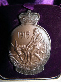
 Melbourne Legacy
Medal, Anzac Commemorative Medal, 1967
... The reverse shows a map in relief of Australia and New Zealand superimposed by the Southern Cross. ...The reverse shows a map in relief of Australia and New Zealand superimposed by the Southern Cross. ...The notepaper says: "In commemoration of the heroic deeds of the men of ANZAC at GALLIPOLI in 1915 and in recognition of the great debt owed by all Australians. With the compliments of the Government of the Commonwealth of Australia." It was given to Legatee Gordon Beith. His son and daughter presented it to Legacy. The Anzac Commemorative Medallion was instituted 1967. It was awarded to surviving members of the Australian forces who served on the Gallipoli Peninsula, or in direct support of the operations from close off shore, at any time during the period from the first Anzac Day in April 1915 to the date of final evacuation in January 1916. (taken from defence.gov.au)Shows the recognition by the Australian Government of the servicemen who served at Gallipoli.ANZAC Commemorative Medallion in brown leather case. Bronze medallion with depiction of Simpson and his donkey carrying a wounded soldier, in a circle with the date 1915. The circle is topped by a crown. It is bordered on the lower half by a laurel wreath above the word ANZAC. The reverse shows a map in relief of Australia and New Zealand superimposed by the Southern Cross. The lower half is bordered by New Zealand fern leaves. The name and initials of the recipient, G. Beith, is engraved on the reverse the engraved name. The presentation case is dark brown leather like outside, with maroon silk lining, and maroon velour cushion for the medalion to rest in. Inside is a printed note on Commonwealth of Australia white notepaper. Accompanying it is a block of wood with inscription of it's donation to Legacy.'G. Beith' engraved on the reverse.gallipoli, medallion, world war one -
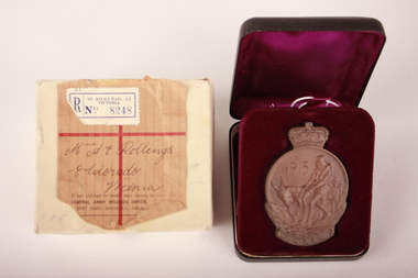 Wangaratta RSL Sub Branch
Medal - Anzac Commemorative Medallion, Raymond Ewers, 1967
... The reverse shows a map in relief of Australia and New Zealand superimposed by the Southern Cross. ...The reverse shows a map in relief of Australia and New Zealand superimposed by the Southern Cross. ...Anzac commemorative medallion issued to the next of kin of Private Thomas Emanuel Rollings - 1983 - 24th Battalion, Wangaratta who served at Gallipoli during WW1The Anzac Commemorative Medallion was instituted 1967. It was awarded to surviving members of the Australian forces who served on the Gallipoli Peninsula, or in direct support of the operations from close off shore, at any time during the period from the first Anzac Day in April 1915 to the date of final evacuation in January 1916.Bronze commemorative medallion depicting Simpson and his donkey on the front and Australia, New Zealand and the southern cross on the back.Medallion is set inside a plastic hinged lid box with a deep purple velvet lining. Original white cardboard box with two sections. Top section has brown paper label with handwritten address and white/blue stamp on outside. The medallion is cast in bronze and is approximately 75 millimetres high and 50 millimetres wide. The obverse of the medallion depicts Simpson and his donkey carrying a wounded soldier to safety. It is bordered on the lower half by a laurel wreath above the word ANZAC. The reverse shows a map in relief of Australia and New Zealand superimposed by the Southern Cross. The lower half is bordered by New Zealand fern leaves. The name and initials of the recipient is engraved on the reverse. The medallion is issued in a presentation box.Medallion - Front: "1915" "ANZAC" Back: "T. E. ROLLINGS" hand engraving Cardboard box - Top section: "St Kilda Rail., S.2 / Victoria / No. 8248"printed "Mrs A E Rollings / Eldorado / Victoria" handwritten "If not claimed in seven days return to :- Central Army Records Office, Albert Park Barracks, Melb" anzac, medallion, commemorative medallion, bronze, eldorado, 24th battalion, wangaratta, gallipoli, ww1 -
 Bendigo Military Museum
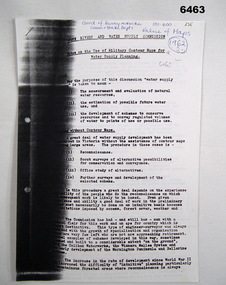
Administrative record - Use of Military maps for water supply planning, 1962
... maps for water supply planning. This demonstrates the value of Military Mapping containing accurate relief information that can then be used for water supply planning....maps for water supply planning. This demonstrates the value of Military Mapping containing accurate relief information that can then be used for water supply planning. ...These are typed notes on the use of Military maps for water supply planning. This demonstrates the value of Military Mapping containing accurate relief information that can then be used for water supply planning.5 x A4 pages of typed notes, poorly photocopiedroyal australian survey corps, rasvy, fortuna, army survey regiment, army svy regt, asr, state rivers and water supply commission -
 Bendigo Military Museum
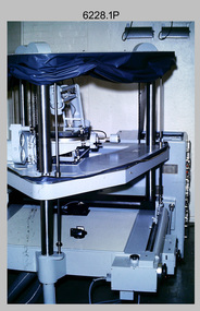
Photograph - Orthorectification Equipment - Army Survey Regiment, Fortuna, Bendigo, c1975, c1988
... Images have tilt and relief distortions that make it difficult to compare accurately a map and an image of the same geographic area. ...Images have tilt and relief distortions that make it difficult to compare accurately a map and an image of the same geographic area. ...Orthophoto mapping provided the Survey Corps with the capability to produce map products quickly in the event of a crisis. These are four photographs of equipment used by the Army Survey Regiment to produce orthophotomaps. The Wild GZ1 orthophoto projector shown in photo.1P was introduced in 1973 and was the first equipment used to orthorectify colour and monochrome film aerial photography. Height profiles were originally produced on a PEB8 Stereo profiler and later were software generated. Photos of the PEB8 are available in Victorian Collections item 6222.17P, photos .5P and .6P. In the same era the IBM 1130 computer; OMI/Nistri AP/C-3 analytical plotter with coordinatograph, OP/C orthophoto projector and Zeiss Planimat D2 stereoplotters were introduced. Orthorectification is the process of removing geometric distortions and scale errors/variations from images. Images have tilt and relief distortions that make it difficult to compare accurately a map and an image of the same geographic area. Once an image is orthorectified, features on the image are shown in their planimetric locations. The WILD OR1 orthophoto projector and workstation shown in photos .2P to.4P was introduced in the mid-1980s. It was the second-generation equipment used to orthorectify colour and monochrome film aerial photography, replacing the system introduced in 1973. See items 6124.5P and 6133.4P for more photographs of orthorectification equipment.These four photographs of orthorectification equipment were taken at the Army Survey Regiment at Fortuna, Bendigo, c1975 and c1988. The photos are on 35mm colour slides and scanned at 96 dpi. They are part of the Army Survey Regiment’s Collection. .1) - Photo, colour, c1975, Wild GZ1 orthophoto projector. .2) - Photo, colour, c1988, WILD OR-1 unrectified colour photo in carrier, orthorectified and re-scaled colour image. .3) & .4) - Photo, colour, c1988, WILD OR-1 Orthorectification Workstation.1P to .4P – Some of the equipment is annotated on the frame of the 35mm slides.royal australian survey corps, rasvy, army survey regiment, asr, army svy regt, fortuna -
 Bendigo Military Museum
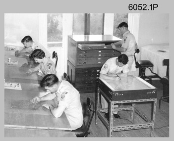
Photograph - Scribing at the Army Survey Regiment, c1950s to 1979
... Scribing was the cartographic process of drafting topographic features such as drainage, relief, vegetation, roads and culture on specially coated map reproduction material. ...Scribing was the cartographic process of drafting topographic features such as drainage, relief, vegetation, roads and culture on specially coated map reproduction material. ...These 10 photographs were taken over two decades from the late 1950s to 1979 at the Army Survey Regiment, Fortuna, Bendigo. The two photos taken in 1961 are annotated with named personnel and the date. The other photos are not annotated with dates, locations and names of personnel, although the technicians in the last three photos taken in 1979 are positively identified. The photos were most likely taken in the Ballroom, Ante Room and Attic, Cartographic Squadron’s main production rooms on the top floor of Fortuna Villa. Scribing was the cartographic process of drafting topographic features such as drainage, relief, vegetation, roads and culture on specially coated map reproduction material. The cartographic technician scribed out the map feature such as a creek to a specified line width on the map sheet, using a tool affixed with a metal or sapphire tipped cutter.This is a set of 10 photographs of technicians scribing topographic features at the Army Survey Regiment, Bendigo. The photographs were printed on photographic paper and are part of the Army Survey Regiment’s Collection. The photographs were scanned at 300 dpi. .1) - Photo, black & white, c1950s. unidentified personnel in Cartographic Squadron .2) - Photo, black & white, c1960s. unidentified personnel in Cartographic Squadron .3) - Photo, black & white, c1960s. unidentified personnel in Cartographic Squadron Attic .4) - Photo, black & white, c1960s. Cartographic Squadron Attic .5) - Photo, black & white, Oct 1961. L to R: PTE P. Carseldine, PTE H.S. Pasley, PTE C.A. Brown, WO2 M.A. McLaren, CPL Jennifer H. Murray. Cartographic Squadron .6) - Photo, black & white, Oct 1961. CPL Jennifer H. Murray. Cartographic Squadron .7) - Photo, black & white, 1979. SPR Mick Ellis in Cartographic Squadron .8) - Photo, black & white, 1979. SPR Mark Casey in Cartographic Squadron .9) - Photo, black & white, 1979. SPR Sharon (Jones) Treble in Cartographic Squadron .10) - Photo, black & white, 1961. PTE BJ Madex. Cartographic Squadron.1 to .4 - annotated “Scribing” .5 – annotated “Scribing PTE P. Carseldine, PTE H.S. Pasley, PTE C.A. Brown, WO2 M.A. McLaren, CPL Jennifer H. Murray. Oct 1961” .6 - annotated “Scribing CPL Jennifer H. Murray. Oct 1961” .7 to .9 - annotated “Scribing” .10 – annotated “PTE Madex Oct 61”royal australian survey corps, rasvy, army survey regiment, army svy regt, fortuna, asr, carto -
 Bendigo Military Museum
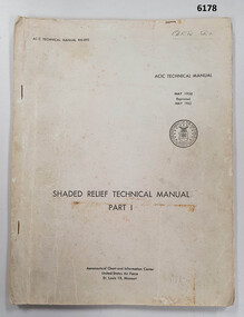
Manual - Shaded Relief Technical Manual - United States Air Force, Department of the Air Force, USA, May 1958
... Shaded relief was produced by hand at the Army Survey Regiment in the 50's, 60's and 70's so that it could be shown on small scale topographical maps and RAAF Aeronauical Charts. ...Shaded relief was produced by hand at the Army Survey Regiment in the 50's, 60's and 70's so that it could be shown on small scale topographical maps and RAAF Aeronauical Charts. ...This manual describes how to hand create "Shaded Relief" or the appearance of hills. This manual was produced by the Aeronautical Chart Information Centre, United States Air Force, St Louis 18, Missouri. Shaded relief was produced by hand at the Army Survey Regiment in the 50's, 60's and 70's so that it could be shown on small scale topographical maps and RAAF Aeronauical Charts. Shaded relief continued to be produced by hand until the mid 1980's when it was replaced by digital production methods.Grey covered Manual, gloss paper, stapled together.royal australian survey corps, rasvy, fortuna, army survey regiment, army svy regt, asr -
 Bendigo Military Museum
Photograph - Cartographic Production – Army Survey Regiment, Fortuna, Bendigo, c1960 -1975
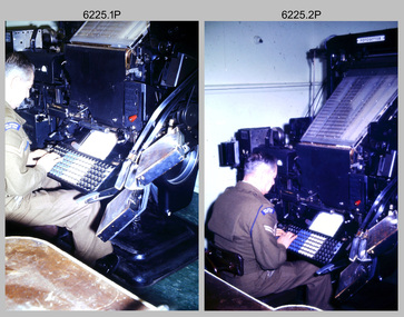
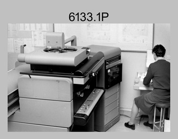
... The scribing process as shown in photos .8P to .9P was the cartographic process of drafting features such as drainage, relief, vegetation, roads and culture on specially coated map reproduction material. ...The scribing process as shown in photos .8P to .9P was the cartographic process of drafting features such as drainage, relief, vegetation, roads and culture on specially coated map reproduction material. ...This is a set of 10 photographs of Cartographic Squadron technicians undertaking map production tasks in at the Army Survey Regiment, Fortuna, Bendigo circa 1968 to 1975. Production was undertaken on the top floor of Fortuna Villa. The Fotosetter type setting machine shown in photos .1P and .2P. replaced the letterpress method of type production in 1956. CPL Arty Lane specialised in the operation of the Fotosetter type setting machine for many years. For more information on the Fotosetter, see page 71 of Valerie Lovejoy’s book 'Mapmakers of Fortuna – A history of the Army Survey Regiment’ ISBN: 0-646-42120-4. The computer based Editwriter Model 7500 typesetting system shown in photos .3P and .4P. was introduced in 1975 as a replacement to the aging Fotosetter. It was operated by a specialised technician, who generated a large variety of map type styles and sizes quickly and reliably, as well as text panels. Output on Copy proof adhesive backed stripping type film replaced messy wax and spray adhesives in 1978. The Editwriter capability supported all RASvy units and its contractor type setting requirements. The Aristo Co-ordinatorgraph shown in photos .5P to .7P was introduced in 1962. It was a large heavy steel framed light table with a scribing head that moved in a XY direction using a vernier calibrated measuring scale to 0.001 of an inch. Whilst hand operated it was much quicker and accurate than manual grid and graticule calculation, plotting and scribing. The history of co-ordinatorgraphs is covered in more detail with additional historic photographs, in pages 50 to 51 and page 88 of Valerie Lovejoy’s book 'Mapmakers of Fortuna – A history of the Army Survey Regiment’ ISBN: 0-646-42120-4. The scribing process as shown in photos .8P to .9P was the cartographic process of drafting features such as drainage, relief, vegetation, roads and culture on specially coated map reproduction material. The cartographic technician scribed out the map feature such as a contour to a specified line width on the map sheet, using a tool affixed with a sapphire tipped cutter. The quality control edit (Proving) stage of map production shown in photo .10P was the first opportunity to independently and systematically inspect a proof of the map.This is a set of 10 photographs of cartographic Squadron technicians undertaking map production tasks at the Army Survey Regiment, Fortuna, Bendigo, c1968 to c1975. The photographs were on 35mm colour slides and scanned at 96 dpi. They are part of the Army Survey Regiment’s Collection. .1) to .2) - Photo, colour, c1968, Fotosetter type setting machine, CPL Arty Lane. .3) to .4) - Photo, colour, c1975, Typesetting machine, ‘Editwriter’ Model 7500. .5) - Photo, colour, c1960s, PTE Desi Asaris and CPL Kalen Sargent operating Aristo Co-ordinatorgraph equipment. .6) - Photo, colour, c1970s, L to R: CPL Desi Asaris, CPL John Bennett, operating Aristo Co-ordinatorgraph equipment. .7) - Photo, colour, c1970s, L to R: CPL John Bennett, CPL Desi Asaris operating Aristo Co-ordinatorgraph equipment. .8) - Photo, colour, c1970s, L to R: CPL Desi Asaris scribing drainage, CPL John Bennett. .9) - Photo, colour, c1970s, CPL Desi Asaris scribing drainage. .10) - Photo, colour, c1970s, L to R: CPL Desi Asaris, CPL John Bennett and their supervisor WO2 Roger Rix inspecting features on an aeronautical chart proof. .1P to .10P There are no annotations stored with the 35mm slides.royal australian survey corps, rasvy, army survey regiment, army svy regt, fortuna, asr, carto -
 Bendigo Military Museum
Photograph - Orthophotomap Workstation, Lithographic Squadron – Army Survey Regiment, Fortuna, Bendigo, 1988
... map products quickly in the event of a crisis. These are four photographs of equipment used by the Army Survey Regiment to produce orthophotomaps. The OR1 orthophoto projector and workstation was introduced in the mid-1980s. It was the second-generation equipment used to orthorectify colour and monochrome film aerial photography, replacing the system introduced in 1973. Orthorectification is the process of removing geometric distortions and scale errors/variations from images. Images have tilt and relief...map products quickly in the event of a crisis. These are four photographs of equipment used by the Army Survey Regiment to produce orthophotomaps. The OR1 orthophoto projector and workstation was introduced in the mid-1980s. It was the second-generation equipment used to orthorectify colour and monochrome film aerial photography, replacing the system introduced in 1973. Orthorectification is the process of removing geometric distortions and scale errors/variations from images. Images have tilt and relief ...This collection of four photos was most likely taken at Lithographic Squadron, Army Survey Regiment, Fortuna, Bendigo in 1988. Orthophoto mapping provided the Survey Corps with the capability to produce map products quickly in the event of a crisis. These are four photographs of equipment used by the Army Survey Regiment to produce orthophotomaps. The OR1 orthophoto projector and workstation was introduced in the mid-1980s. It was the second-generation equipment used to orthorectify colour and monochrome film aerial photography, replacing the system introduced in 1973. Orthorectification is the process of removing geometric distortions and scale errors/variations from images. Images have tilt and relief distortions that make it difficult to compare accurately a map and an image of the same geographic area. Once an image is orthorectified, features on the image are shown in their planimetric locations. These four photographs of orthorectification equipment in operation were taken at the Army Survey Regiment at Fortuna, Bendigo, 1988. The photographs were on 35mm negative film and were scanned at 96 dpi. They are part of the Army Survey Regiment’s Collection. .1) to .4) - Photo, black & white, 1988, WILD OR-1 Orthorectification Workstation, SPR Carmel (Butler) Fauth.No personnel are identifiedroyal australian survey corps, rasvy, army survey regiment, army svy regt, fortuna, asr, litho -
 Bendigo Military Museum
photograph - Cartographic Squadron Production – Army Survey Regiment, Fortuna, c1980
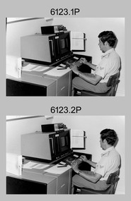
... map type styles and sizes quickly and reliably, as well as text panels. CPL Richards performed this task for several years and in photo .1P and .2P is reading off a type order next to the computer monitor. Output on Copy proof adhesive backed stripping type film replaced messy wax and spray adhesives in 1978. The Editwriter capability supported all RASvy units and contractor type setting requirements. Scribing was the cartographic process of drafting features such as drainage, relief...map type styles and sizes quickly and reliably, as well as text panels. CPL Richards performed this task for several years and in photo .1P and .2P is reading off a type order next to the computer monitor. Output on Copy proof adhesive backed stripping type film replaced messy wax and spray adhesives in 1978. The Editwriter capability supported all RASvy units and contractor type setting requirements. Scribing was the cartographic process of drafting features such as drainage, relief ...This collection of 12 photos was most likely taken in 1980. The photos were most likely taken in Cartographic Squadron’s Ante Room, the Attic and small offices on the top floor of Fortuna Villa. The computer based Editwriter typesetting system was introduced in 1975 as a replacement to the aging Fotosetter machine. It was operated by a specialised technician, who generated a large variety of map type styles and sizes quickly and reliably, as well as text panels. CPL Richards performed this task for several years and in photo .1P and .2P is reading off a type order next to the computer monitor. Output on Copy proof adhesive backed stripping type film replaced messy wax and spray adhesives in 1978. The Editwriter capability supported all RASvy units and contractor type setting requirements. Scribing was the cartographic process of drafting features such as drainage, relief, vegetation, roads and culture on specially coated map reproduction material. The cartographic technician scribed out the map feature such as a contour to a specified line width on the map sheet, using a tool affixed with a sapphire tipped cutter. The quality control edit (Proving) stage of map production was the first opportunity to inspect a proof of the map independently and systematically. Proving tasks were carried out by technicians conversant of the map product specification and task requirement, however, was not involved in its production. Corrections were identified, marked up and sent to back to the correcting section or contractors. Terrain Embossing was a manual map production technique to produce hill shading on medium to small scale graphics and air charts. SPR John Martin is seen in photos .8P to.10P using a fine embossing metal stylus to push down on the drainage impression on a thin malleable opaque plastic material (AK Poligraphy). Ridge lines were then pushed down using the contour impression as a guide, on the opposing side of the AK Poligraphy to create a 3D plastic model terrain effect. The map impression was sprayed with white paint and photographed to create a contone tone hill shade. SPR Gina (Coore) Neilson is seen in photo .11P washing a contone positive of a land mass in a solution. The contone components were registered to the map sheet, as shown in photo .12P and masked using an air brush and a halftone negative was then created. The terrain embossing method of producing hill shading was more efficient to produce than previous specialised artistic methods such pencil/eraser and air brush. Furthermore, a more consistent enhancement of terrain on charts was achieved between technicians.This is a set of 12 photographs of Cartographic Squadron performing four map production tasks at the Army Survey Regiment, Fortuna, Bendigo c1980. The first ten photographs were on 35mm negative film and were scanned at 96 dpi. Photos .11P and .12P were on photographic paper and scanned at 300 dpi. They are part of the Army Survey Regiment’s Collection. .1) - Photo, black & white, c1980, Editwriter typesetter, CPL Paul Richards. .2) - Photo, black & white, c1980, Editwriter typesetter, CPL Paul Richards. .3) - Photo, black & white, c1980, Scribing contours on a RAAF Chart, SPR Megan (McBurney) Reynolds. .4) - Photo, black & white, c1980, Scribing contours on a RAAF Chart, SPR Megan (McBurney) Reynolds. .5) - Photo, black & white, c1980, Scribing contours on a RAAF Chart, SPR Rod Skidmore. .6) - Photo, black & white, c1980, Scribing contours on a RAAF Chart, SPR Rod Skidmore. .7) - Photo, black & white, c1980, Formal quality control edit (Proving), CPL Ian Belmont. .8) - Photo, black & white, c1980, Hill Shade Terrain Embossing, SPR John Martin. .9) - Photo, black & white, c1980, Hill Shade Terrain Embossing, SPR John Martin. .10) - Photo, black & white, c1980, Hill Shade Terrain Embossing, SPR John Martin. .11) - Photo, black & white, c1980, Hill Shade Terrain Embossing, SPR Gina (Coore) Neilson. .12) - Photo, black & white, c1980, Hill Shade Terrain Embossing, unidentified..1P to .10P No personnel are identified. .11P and .12P annotated ‘Terrain Embossing’royal australian survey corps, rasvy, army survey regiment, army svy regt, fortuna, asr, carto -
 Bendigo Military Museum
photograph - Orthorectification Equipment - Army Survey Regiment, Fortuna, Bendigo, c1975
... Images have tilt and relief distortions that make it difficult to compare accurately a map and an image of the same geographic area. ...Images have tilt and relief distortions that make it difficult to compare accurately a map and an image of the same geographic area. ...Orthophoto mapping provided the Survey Corps with the capability to produce map products quickly in the event of a crisis. These are four photographs of equipment used by the Army Survey Regiment to produce orthophotomaps. The Wild GZ1 orthophoto projector was introduced in 1973 and was the first equipment used to orthorectify colour and monochrome film aerial photography. Height profiles were originally produced on a PEB8 Stereo profiler and later were software generated. Photos of the PEB8 are available in Victorian Collections item 6222.17P, photos .5P and .6P. In the same era the IBM 1130 computer; OMI/Nistri AP/C-3 analytical plotter with coordinatograph, OP/C orthophoto projector and Zeiss Planimat D2 stereoplotters were introduced. Orthorectification is the process of removing geometric distortions and scale errors/variations from images. Images have tilt and relief distortions that make it difficult to compare accurately a map and an image of the same geographic area. Once an image is orthorectified, features on the image are shown in their planimetric locations. These four photographs of orthorectification equipment were taken at the Army Survey Regiment at Fortuna, Bendigo, c1975. Photo .1P and .3P were printed on photographic paper and scanned at 300 dpi. Photos .2P, .4P and .5P were on 35mm negative film and scanned at 96 dpi. They are part of the Army Survey Regiment’s Collection. .1) - Photo, black & white, c1975, Wild GZ1 orthophoto projector operated by CPL Phil Boyle. .2) - Photo, black & white, c1975, Wild GZ1 orthophoto projector. .3) - Photo, black & white, c1975, Wild GZ1 orthophoto projector. .4) - Photo, black & white, c1978, Zeiss D2 Planimat Stereoplotter. .5) - Photo, black & white, c1978, Zeiss D2 Planimat Stereoplotter..1P to .5P No annotations.royal australian survey corps, rasvy, army survey regiment, army svy regt, fortuna, asr -
 Bendigo Military Museum
Booklet - ORTHOPHOTOMAPPING IN THE ROYAL AUSTRALIAN SURVEY CORPS 1977, Army Svy Regt Tech Svcs Jun 77, Jun 1977
... An orthophoto or orthophoto map is a highly accurate geometrically corrected aerial or satellite image where distortions from camera tilt and terrain relief have been removed, resulting in a uniform scale. ...An orthophoto or orthophoto map is a highly accurate geometrically corrected aerial or satellite image where distortions from camera tilt and terrain relief have been removed, resulting in a uniform scale. ...The booklet outlines in detail all aspects of Orthophoto mapping including current equipment, reproduction techniques and the role of orthophoto maps as produced by the Royal Australian Survey Corps. An orthophoto or orthophoto map is a highly accurate geometrically corrected aerial or satellite image where distortions from camera tilt and terrain relief have been removed, resulting in a uniform scale. It therefore acts as a "map accurate" photograph allowing for precise measurements of distances and areas. A4 size booklet of 23 numbered pagesroyal australian survey corps, fortuna, army survey regiment, rasvy, asr -
 Lara RSL Sub Branch
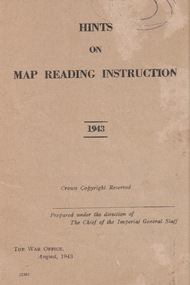
Booklet, Hints of Map Reading Instruction 1943, 00/08/43
... The map as a plan, as a reference point, a measurement of distance, a relief and direction in any situation ...The map as a plan, as a reference point, a measurement of distance, a relief and direction in any situation booklet map instruction 1943 ReservedFront page has the name of the booklet with added date 1943. ...Used to instruct the serviceman how to read and question learnt material about map reading. The map as a plan, as a reference point, a measurement of distance, a relief and direction in any situation Paper Booklet with 24 pages that have faded to a beige colour A5 in size ReservedFront page has the name of the booklet with added date 1943. Crown Copyright. Prepared under the direction of the Imperial General Staff The War Office August 1943 22307booklet, map instruction, 1943 -
 Lara RSL Sub Branch
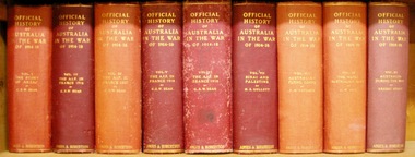
Book, Official History of Australia in the War of 1914-18 - Volume IV - The AIF in France 1917 Author C.E.W.Bean, Fifth edition 1937
... Lara RSL Sub Branch McClelland Ave Lara This volume discovers four of the five Australian Infantry Divisions expecting relief after their most depressing experience, the winter of 1916-17on the Somme. australian infantry divisions british armies hindenburg line bullecourt battle of messines battle of passchendaele polygon wood france ypres broodseinde ridge hill 60 Official History of Australia in the War of 1914-18 - Volume IV - The AIF in France 1917 Hardcover cardboard, Chronology, Maps, Illustrations Official History of Australia in the War of 1914-18 - Volume IV - The AIF in France 1917 Author C.E.W.Bean Book ...This volume discovers four of the five Australian Infantry Divisions expecting relief after their most depressing experience, the winter of 1916-17on the Somme.Official History of Australia in the War of 1914-18 - Volume IV - The AIF in France 1917 Hardcover cardboard, Chronology, Maps, Illustrationsaustralian infantry divisions, british armies, hindenburg line, bullecourt, battle of messines, battle of passchendaele, polygon wood, france, ypres, broodseinde ridge, hill 60 -
 Lara RSL Sub Branch
Medallion, W.H.Mathews, 1967
... The reverse shows a map in relief of Australia and New Zealand superimposed by the Southern Cross. ...The reverse shows a map in relief of Australia and New Zealand superimposed by the Southern Cross. ...Every Anzac soldier who served on the Gallipoli Peninsula, or in direct support of operations there - or his family if he did not survive until into the late 1960s - was entitled to be issued with the Anzac Commemorative Medallion. The Medallion was issued in 1967. The medallion was sent by registered post and comes in a presentation case with a moulded velvet base to receive the medallion, with a silk lined hinged lid.Medallion presented to all army personnel serving at GallipoliANZAC Medallion Badge issued in memory of W.H. MathewsThe obverse of the medallion depicts Simpson and his donkey carrying a wounded soldier to safety. It is bordered on the lower half by a laurel wreath above the word ANZAC and the date 1915 above the donkey. The reverse shows a map in relief of Australia and New Zealand superimposed by the Southern Cross. The lower half is bordered by New Zealand fern leaves and the name W.M. Mathewsmedallion, army, anzacs, australian army, world war 1, ww1, gallipoli -
 Montmorency–Eltham RSL Sub Branch
Medal - Military Kid Medallion, Foxhole Medals, After 2004
... On reverse: "For perseverance on the home front during your parents deployment"; map of Australia (haut relief)...Presented by the Government to children whose parents had served overseas military kid military medal kids medal On reverse: "For perseverance on the home front during your parents deployment"; map of Australia (haut relief) Silver medal with pale green, yellow, orange and deeper green ribbon. ...This medal was presented to the children of Victorian Wing - Warrant Officer and Non Commissioned Officers Academy Soldier who have served on operational deployments. As these young children endured an operational deployment of a parent who spent many months away from home in a foreign country representing the Australian Army. Following operations include Bougainville, East Timor, Indian Ocean, Solomon Islands, Meddle East Area, Afghanistan and Sinai.Presented by the Government to children whose parents had served overseas Silver medal with pale green, yellow, orange and deeper green ribbon. It has a metal type container with a clear plastic front and also a black carry bag with Military Kid and print of medal on front. The design is based on the Australian Tri Service Logo. More detailed information can be found on Military Kids websiteOn reverse: "For perseverance on the home front during your parents deployment"; map of Australia (haut relief)military kid, military medal, kids medal -
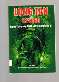 Monbulk RSL Sub Branch
Book, Cobbs Crossing Publication, Long Tan and beyond : Alpha Company 6 RAR in Vietnam 1966-67, 2006
... relief force - the men who turned defeat into victory. More than that, it is a story told by soldiers about soldiers. You will laugh and cry with them. Index, ill, maps ...Here for the first time is included the story about the relief force - the men who turned defeat into victory. More than that, it is a story told by soldiers about soldiers. You will laugh and cry with them.Index, ill, maps, p.478.non-fictionHere for the first time is included the story about the relief force - the men who turned defeat into victory. More than that, it is a story told by soldiers about soldiers. You will laugh and cry with them.battle of long tan, vietnam conflict - australian involvement