Showing 4573 items matching "roads and bridges"
-
 Mont De Lancey
Booklet, Department of Main Roads, Toll Roads and Bridges, 1981
... Toll Roads and Bridges......Roads...Early toll roads and bridge use in Australia from early settlement days to 1981....Green and white edging surrounds the picture with the title Toll Roads and Bridges printed in black lettering at the top right of the cover. ...Road Tolls Roads Bridges History of tolls A brief history of tolls used throughout history, dating back around 1950 B.C. ...A brief history of tolls used throughout history, dating back around 1950 B.C. Early English and USA use is mentioned. Road and bridge tolls in Australia were collected for construction and maintenance of particular roads and bridges similar to their use in England. The clear photographs show the development in the this country up to 1981 when the brochure was published.A small slim rectangular paperback brochure with a lithograph of the "New Toll Gate" on Parramatta Road, published in J.G. Austin's Sydney Views. Green and white edging surrounds the picture with the title Toll Roads and Bridges printed in black lettering at the top right of the cover. On the back is a photograph of Toll cabins at the northern end of the Sydney Harbour Bridge showing automatic and manual toll booths with the symbol for NAASRA and National Association of Australian State Road Authorities printed in black and white at the bottom. Pp. 20. There are many photographs inside.non-fictionA brief history of tolls used throughout history, dating back around 1950 B.C. Early English and USA use is mentioned. Road and bridge tolls in Australia were collected for construction and maintenance of particular roads and bridges similar to their use in England. The clear photographs show the development in the this country up to 1981 when the brochure was published.road tolls, roads, bridges, history of tolls -
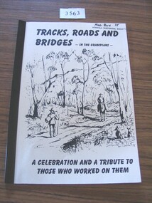 Stawell Historical Society Inc
Book, Ida Stanton, Tracks, Roads & Bridges, In the Grampians, 2002
... Tracks, Roads & Bridges, In the Grampians ...A History of the Roads, Tracks and Bridges in the Grampians...TRacks, Roads and Bridges - In the Grampians. A Celebration and a Tribute to those who worked on them....Stawell Historical Society Inc 46 Longfield St Stawell grampians A History of the Roads, Tracks and Bridges in the Grampians stawell TRacks, Roads and Bridges - In the Grampians. ...A History of the Roads, Tracks and Bridges in the GrampiansCrean paper cover with a line drawing of "Entering the Gap" Circa 1870 by Laurie Evans. Plastic BindingTRacks, Roads and Bridges - In the Grampians. A Celebration and a Tribute to those who worked on them.stawell -
 Marysville & District Historical Society
Document (item) - Report, Clement Wilks, Track to the River Jordan Gold Fields, 1864-1865
... ...Department of Roads & Bridges...Track to the River Jordan Gold Fields Document Report Clement Wilks Department of Roads & Bridges John Ferres ...A report by Mr Road Engineer Wilks on the construction of the Yarra Track in Victoria.A report by Mr Road Engineer Wilks on the construction of the Yarra Track in Victoria. The Yarra Track is the former name of the gold fields road from Healesville to the Woods Point and Jordan Goldfields, in Victoria, Australia. By Authority: JOHN FERRES, Government Printer, Melbourneclement wilks, yarra track, marysville, victoria, wood's point, healesville, jordan gold fields -
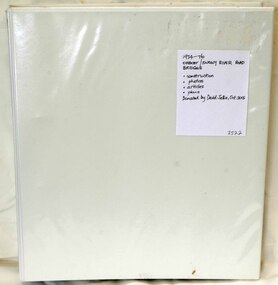 Orbost & District Historical Society
folder, Orbost Bridges - Snowy River Road Bridges, 1974 1976
... In early 1974, as an Engineer with the Country Roads Board, David came to Orbost as the Supervising Engineer for the construction of the new bridges which were part of an 8.4km Orbost bypass road design. ...A white plastic folder - Orbost Bridges - Snowy River Road Bridges. it contains newspaper articles, booklets, photographs and documents relating to the construction of the Snowy River Road Bridge in 1974 -1976....on front cover - 1974 - 76 ORBOST / SNOWY RIVER ROAD BRIDGES * construction * photos * articles * plans Donated by David Jellie Oct 2015...Orbost Bridges - Snowy River Road Bridges folder Jellie, David ...This folder was compiled in October 2015 from documents, magazines. papers and photographs donated by David Jellie, engineer in charge 1974 - 1976. In early 1974, as an Engineer with the Country Roads Board, David came to Orbost as the Supervising Engineer for the construction of the new bridges which were part of an 8.4km Orbost bypass road design. This was a major project involving not only a new bridge over the Snowy River (including Lochiel Lagoon), but other bridges over Ashby’s Gulch and Watt’s Gulch. These new bridges were opened in November 1976 with the unveiling of a plaque on the eastern end of the $2.4M Snowy River Bridge. (ref. May Leatch)This item is a useful reference tool on the construction history of the Snowy River Road bridges.A white plastic folder - Orbost Bridges - Snowy River Road Bridges. it contains newspaper articles, booklets, photographs and documents relating to the construction of the Snowy River Road Bridge in 1974 -1976.on front cover - 1974 - 76 ORBOST / SNOWY RIVER ROAD BRIDGES * construction * photos * articles * plans Donated by David Jellie Oct 2015snowy-river-bridges jellie-david -
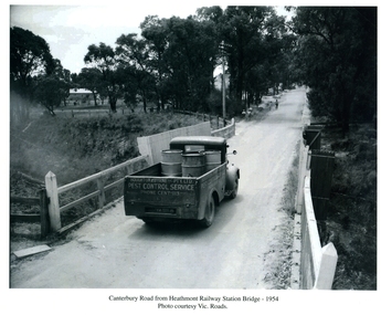 Ringwood and District Historical Society
Photograph, Canterbury Road from Heathmont Railway Station Bridge 1954, 1954
... Canterbury Road from Heathmont Railway Station Bridge 1954...Houghton & Byrne Pest Service Truck on Canterbury Road crossing Heathmont Railway Station Bridge 1954. ...Canterbury Road from Heathmont Railway Station Bridge - 1954. ...Photo courtesy Vic. Roads Canterbury Road from Heathmont Railway Station Bridge 1954 Photograph ...Houghton & Byrne Pest Service Truck on Canterbury Road crossing Heathmont Railway Station Bridge 1954. Photo courtesy Vic. RoadsCanterbury Road from Heathmont Railway Station Bridge - 1954. Photo courtesy Vic. Roads -
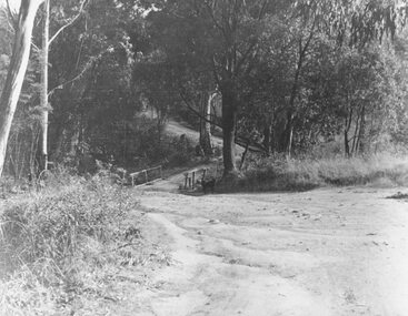 Ringwood and District Historical Society
Photograph, Deep Creek Road bridge early 1900s
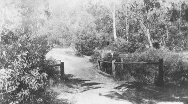
... Deep Creek Road bridge early 1900s....Black and white photograph taken from unmade road. Road zigzags over bridge with wooden balustrades. ...Typed below photograph, "Deep Creek Road bridge in the early days"....Black and white photograph taken from unmade road. Road zigzags over bridge with wooden balustrades. ...Black and white photograph taken from unmade road. Road zigzags over bridge with wooden balustrades. Bushland setting. (3 copies)Typed below photograph, "Deep Creek Road bridge in the early days". -
 Ringwood and District Historical Society
Photograph, Deep Creek bridge and road c.1935
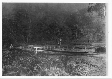
... Deep Creek bridge and road c.1935...Black and white photograph of narrow unmade road showing narrow bridge with wooded balustrades. ...Typed below photograph, "Deep Creek bridge and road. c.1935"....Forested area at edge of roadway. Deep Creek bridge and road c.1935 Photograph ...Black and white photograph of narrow unmade road showing narrow bridge with wooded balustrades. Forested area at edge of roadway.Typed below photograph, "Deep Creek bridge and road. c.1935". -
 Stawell Historical Society Inc
Photograph, Harris Bridge – Red Bend Road -- Great Western
... Harris Bridge – Red Bend Road -- Great Western...Harris Bridge – Red Bend Road Great Western....Harris' Bridge Red bend Road Great Western...Stawell Historical Society Inc 46 Longfield St Stawell grampians Harris Bridge – Red Bend Road Great Western. stawell Harris' Bridge Red bend Road Great Western Black & white photo of Bridge. ...Harris Bridge – Red Bend Road Great Western.Black & white photo of Bridge. Photo is out of focus so hard to work out.Harris' Bridge Red bend Road Great Westernstawell -
 Halls Gap & Grampians Historical Society
Photograph, C 1911
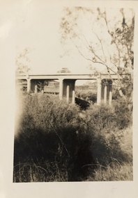
... ...roads...The photo shows a dirt road crossing a creek via a wooden bridge. ...The collapsed western end was rebuilt, this time supported by concrete pillars. access routes roads structures bridges The photo shows a dirt road crossing a creek via a wooden bridge. ...This is the second Delley''s Bridge. A new and more substantial bridge was built in 1911, only to be badly damaged in a 1917 flood. The collapsed western end was rebuilt, this time supported by concrete pillars.The photo shows a dirt road crossing a creek via a wooden bridge. A woman is driving a horse and buggy onto the far end of the bridge. There are ferns in the foreground and trees in the background.access routes, roads, structures, bridges -
 Eltham District Historical Society Inc
Photograph, Construction of Lower Plenty Bridge, Main Road, c.August 1966, 1966
... Construction of Lower Plenty Bridge, Main Road, c.August 1966...Construction activity of a new Main Road bridge over the Plenty River at Lower Plenty in 1966. ...Black and white photograph of construction of new bridge, Main Road, Lower Plenty...The new bridge followed a realignment of the road and old Lower Plenty bridge remained in situ and is now part of the Plenty River Trail. bridge construction main road lower plenty plenty river bridges Black and white photograph of construction of new bridge, Main Road, Lower Plenty Construction of Lower Plenty Bridge, Main Road, c.August 1966 Photograph ...Construction activity of a new Main Road bridge over the Plenty River at Lower Plenty in 1966. The new bridge followed a realignment of the road and old Lower Plenty bridge remained in situ and is now part of the Plenty River Trail.Black and white photograph of construction of new bridge, Main Road, Lower Plentybridge construction, main road, lower plenty, plenty river, bridges -
 Kew Historical Society Inc
Photograph, Burke Road Bridge, 1930s
... Burke Road Bridge...Private and public bridges were constructed from the 1850s, beginning with the Hawthorn Bridge linking Bridge and Burwood Roads. ...Sepia, faded photograph of the Burke Road Bridge linking East Kew and Ivanhoe. The previous bridge, constructed in 1926 was submerged beneath the flood waters in the 1934 mega-flood of the Yarra....Burke Road Bridge Photograph Photograph ...Without bridges, Kew remained cut off from the City of Melbourne, only being accessible by Punt. Private and public bridges were constructed from the 1850s, beginning with the Hawthorn Bridge linking Bridge and Burwood Roads. A bridge across the Yarra at Burke Road was created as early as 1873. Since that first wooden bridge, a number of later bridges, typically on concrete pylons have been built, in 1926 and again during the 1970s.Sepia, faded photograph of the Burke Road Bridge linking East Kew and Ivanhoe. The previous bridge, constructed in 1926 was submerged beneath the flood waters in the 1934 mega-flood of the Yarra.burke road bridge (kew), bridges -- river yarra -
 Eltham District Historical Society Inc
Photograph, Construction of new bridge over the Plenty River, Main Road, Lower Plenty, 13 July 1966
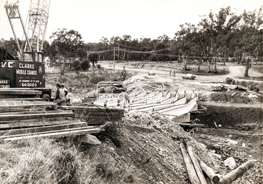
... Construction of new bridge over the Plenty River, Main Road, Lower Plenty...Construction activity of a new Main Road bridge over the Plenty River at Lower Plenty in 1966. ...Marking on back of photograph - Plenty River Bridge Main Road 1969 (sic)...Construction activity of a new Main Road bridge over the Plenty River at Lower Plenty in 1966. ...Construction activity of a new Main Road bridge over the Plenty River at Lower Plenty in 1966. The new bridge followed a realignment of the road and old Lower Plenty bridge remained in situ and is now part of the Plenty River Trail. Includes structural members, construction personnel, vehicles and a Clarke mobile crane. Published Diamind Valley News, Tuesday, July 19, 1966, p1 Piecing Bridge Together A tall crane was used last Wednesday to lift and place in position the concrete and steel girders for the sub-structure of the new Lower Plenty Bridge. The picture shows the girders in position, looking towards the approach on the Lower Plenty side.Local significanceBlack and white printMarking on back of photograph - Plenty River Bridge Main Road 1969 (sic)lower plenty, main road, plenty river, bridge, bridge construction, civil engineering, cranes, mobile cranes -
 Sunshine and District Historical Society Incorporated
Map - River Concept Plan Maribyrnong River Area 3 (Lower Maribyrnong, Railway Bridge to Dynon Road) 30th October 1989 Map, 30th October 1989
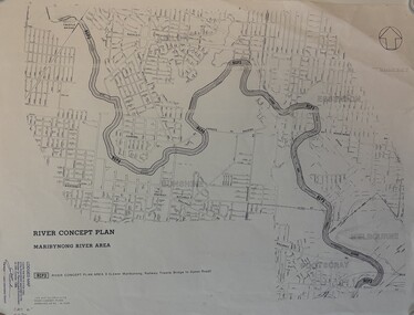
... Paper Map showing the River Concept Plan Maribyrnong River Area 3 (Lower Maribyrnong, Railway Bridge to Dynon Road) 30th October 1989...River Concept Plan Maribyrnong River Area 3 (Lower Maribyrnong, Railway Bridge to Dynon Road) 30th October 1989...Maribyrnong River Footscray River Concept Plan Maribyrnong River Area 3 (Lower Maribyrnong, Railway Bridge to Dynon Road) 30th October 1989 Paper Map showing the River Concept Plan Maribyrnong River Area 3 (Lower Maribyrnong, Railway Bridge to Dynon Road) 30th October 1989 Map River Concept Plan Maribyrnong River Area 3 (Lower Maribyrnong, Railway Bridge to Dynon Road) 30th October 1989 Map ...River Concept Plan Maribyrnong River Area 3 (Lower Maribyrnong, Railway Bridge to Dynon Road) 30th October 1989maribyrnong river, footscray -
Glenelg Shire Council Cultural Collection
Photograph - Photograph - Bridge Construction, 29/05/1957
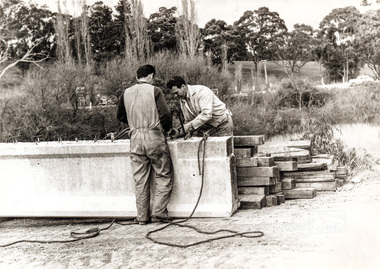
... Black and white photo of Bridgewater Road (Otway Street) bridge under construction. ...Front: Back- 'Bridgewater road Bridge (otway street) 29/5/57' - pencil...Glenelg Shire Council Cultural Collection History House Cliff Street Portland great-ocean-road Port of Portland Authority Archives Port of Portland Front: Back- 'Bridgewater road Bridge (otway street) 29/5/57' - pencil Black and white photo of Bridgewater Road (Otway Street) bridge under construction. ...Port of Portland Authority ArchivesFront: Back- 'Bridgewater road Bridge (otway street) 29/5/57' - pencilport of portland -
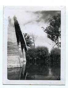
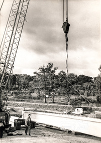
 Orbost & District Historical Society
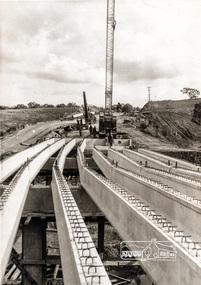
black and white photographs, 1975
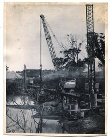
... These are photographs of the construction of the current cement road bridge across the Snowy River at Orbost. ...Two black / white photographs showing the construction of a road bridge across a river. 3257.1 shows piles being dropped beside the bridge, 3257.2 is of the early stages of construction of this bridge....These photographs record its construction. Snowy-River-bridge-Orbost road-construction-Orbost bridge-Orbost Two black / white photographs showing the construction of a road bridge across a river. 3257.1 shows piles being dropped beside the bridge, 3257.2 is of the early stages of construction of this bridge. black and white photographs ...These are photographs of the construction of the current cement road bridge across the Snowy River at Orbost. Construction of the bridges commenced in January 1975, with an expectation to open the bridge across the Snowy River as soon as possible. Less than two years later, on 25 November 1976, the bridge across the Snowy River was opened to traffic, allowing the old bridge to be demolished. The remainder of the Orbost Bypass, both the floodplain crossings and the eastern section around the township itself, was declared ‘Princes Freeway’ and opened to traffic in December 1977. (ref http://mrv.ozroads.com.au)The opening of this Snowy River Bridge was an important development in the accessibility to the township of Orbost. These photographs record its construction.Two black / white photographs showing the construction of a road bridge across a river. 3257.1 shows piles being dropped beside the bridge, 3257.2 is of the early stages of construction of this bridge.snowy-river-bridge-orbost road-construction-orbost bridge-orbost -
Glenelg Shire Council Cultural Collection
Photograph - Photograph - Bridgewater Construction, n.d
... Black and white photo of Otway street/Bridgewater road bridge under construction. Men working on scaffolding for concrete pylons, in excavated area. ...'C' 4x2 1/4 - Pencil 'Bridgewater road bridge 29/3/57 looking s.s.w'- written in blue biro. ...'Otway Street Bridge - Pencil Black and white photo of Otway street/Bridgewater road bridge under construction. ...Port of Portland Authority ArchivesFront: Back- Margin ruled in pencil, diagonal in pencil. 'C' 4x2 1/4 - Pencil 'Bridgewater road bridge 29/3/57 looking s.s.w'- written in blue biro. 'Otway Street Bridge - Pencilport of portland archives, otway street bridge, bridgewater road bridge construction -
 Orbost & District Historical Society
black and white photographs, C1970
... These photographs are of the 1922 road bridge across the Snowy River at Orbost. ...Two small black / white photographs of a road bridge across a river. 3248.1 is a close-up of wooden pylons....Orbost & District Historical Society Ruskin Street Orbost gippsland These photographs are of the 1922 road bridge across the Snowy River at Orbost. ...These photographs are of the 1922 road bridge across the Snowy River at Orbost. This bridge over the Snowy River was opened on July 4 1922. It was constructed in 1922 alongside the previous suspension bridge. Its building was a combined effort of the Victorian Railways and the Country Roads Board at a cost of 35,000 pounds. It was replaced in 1976 by the present bridge after several major floods.This bridge was replaced in 1976 after several major floods. These photographs are pictorial records of the 1922 brige.Two small black / white photographs of a road bridge across a river. 3248.1 is a close-up of wooden pylons.on label on back - "Snowy River Bridge at Orbost 1922 Bridge"bridge-orbost snowy-river-bridge -
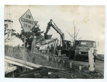 Orbost & District Historical Society
black and white photographs, 1976 - 1977
... These photographs are of the demolition of the road bridge across the Snowy River at Orbost. ...Four black / white photographs of the demolition of a road bridge across a river. In them can be seen trucks, excavators and workmen. ...These photographs are pictorial records of its demolition. bridge-demolition Orbost-Snwoy-River-bridge Four black / white photographs of the demolition of a road bridge across a river. ...These photographs are of the demolition of the road bridge across the Snowy River at Orbost. This bridge over the Snowy River was opened on July 4 1922. It was constructed in 1922 alongside the previous suspension bridge. Its building was a combined effort of the Victorian Railways and the Country Roads Board at a cost of 35,000 pounds. It was replaced in 1976 by the present bridge after several major floods.This bridge was replaced in 1976 after several major floods. These photographs are pictorial records of its demolition.Four black / white photographs of the demolition of a road bridge across a river. In them can be seen trucks, excavators and workmen. In 3246.1 there is a triangular road sign - "LOW CLEARANCE 3.9m"bridge-demolition orbost-snwoy-river-bridge -
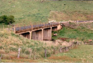 Hume City Civic Collection
Photograph, c 1980s
... The Gillies Bridge is situated on Wildwood Road which runs off Lancefield Road. ...A coloured photograph of a concrete road bridge spanning a small creek. The bridge has four arches. ...It spans the Deep Creek. gillies bridge wildwood road bridges george evans collection A coloured photograph of a concrete road bridge spanning a small creek. ...The Gillies Bridge is situated on Wildwood Road which runs off Lancefield Road. It spans the Deep Creek.A coloured photograph of a concrete road bridge spanning a small creek. The bridge has four arches. Two people are standing above the 4th arch on the roadway. The hillsides on either side of the valley are bare.gillies bridge, wildwood road, bridges, george evans collection -
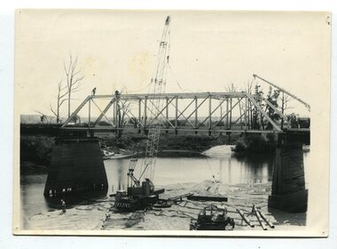 Orbost & District Historical Society
black and white photographs, 1977
... It was constructed in 1922 alongside the previous suspension bridge. Its building was a combined effort of the Victorian Railways and the Country Roads Board at a cost of 35,000 pounds. ...Ten black / white photographs of a road bridge demolition. In the photographs are cranes, one on a barge, and workmen...These photographs record the demolition of that bridge. on back - Orbost Snowy River Bridge demolition 1977 Ten black / white photographs of a road bridge demolition. ...This is a series of photographs of the demolition of the 1922 bridge across the Snowy River at Orbost. This bridge over the Snowy River was opened on July 4 1922. It was constructed in 1922 alongside the previous suspension bridge. Its building was a combined effort of the Victorian Railways and the Country Roads Board at a cost of 35,000 pounds. It was replaced in 1976 by the present bridge after several major floods.This bridge was replaced in 1976 after several major floods. These photographs record the demolition of that bridge.Ten black / white photographs of a road bridge demolition. In the photographs are cranes, one on a barge, and workmenon back - Orbost Snowy River Bridge demolition 1977 -
 Clunes Museum
Photograph
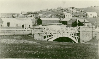
... PHOTOGRAPH OF GOVERNMENT BRIDGE OVER CRESWICK CREEK ON CRESWICK ROAD, CLUNES. ...BLACK AND WHITE PHOTOGRAPH OF BRIDGE OVER CRESWICK CREEK AT CLUNES - GOVERNMENT BRIDGE, CRESWICK ROAD. ...SEMMENS FROM AN EARLIER PHOTOGRAPH. local history photography photographs BLACK AND WHITE PHOTOGRAPH OF BRIDGE OVER CRESWICK CREEK AT CLUNES - GOVERNMENT BRIDGE, CRESWICK ROAD. ...PHOTOGRAPH OF GOVERNMENT BRIDGE OVER CRESWICK CREEK ON CRESWICK ROAD, CLUNES. PHOTOGRAPH DONATED BY CRESWICK MUSEUM. COPIED BY MR. SEMMENS FROM AN EARLIER PHOTOGRAPH.BLACK AND WHITE PHOTOGRAPH OF BRIDGE OVER CRESWICK CREEK AT CLUNES - GOVERNMENT BRIDGE, CRESWICK ROAD. EBERHARDS SOFT DRINK FACTORY IN CENTRE OF PHOTOGRAPH.local history, photography, photographs -
 Kew Historical Society Inc
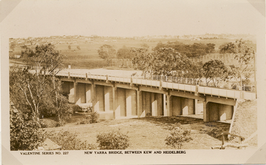
Postcard, Valentine Publishing Co Pty Ltd, New Yarra Bridge, Between Kew and Heidelberg, 1926-1930
... Private and public bridges were constructed from the 1850s, beginning with the Hawthorn Bridge linking Bridge and Burwood Roads. ...Angle view of the new Yarra bridge [ie. The Burke Road bridge] taken from the Kew side, showing the bridge’s structure. ...The Burke Road bridge] taken from the Kew side, showing the bridge’s structure. ...Without bridges, Kew remained cut off from the City of Melbourne, only being accessible by Punt. Private and public bridges were constructed from the 1850s, beginning with the Hawthorn Bridge linking Bridge and Burwood Roads. A bridge across the Yarra at Burke Road was created as early as 1873. Since that first wooden bridge, a number of later bridges, typically on concrete pylons have been built, in 1926 and again during the 1970s.Angle view of the new Yarra bridge [ie. The Burke Road bridge] taken from the Kew side, showing the bridge’s structure. Trees line the river’s edge. In the distance can be seen a distant line of houses stretching to the horizon. The river appears to have an S-shaped bend beyond the bridge. The postcard, No. 227, was produced by the Valentine Publishing Co. Pty Ltd., of Queen Street, Melbourne.burke road bridge - kew (vic), bridges - kew (vic) -
 Eltham District Historical Society Inc
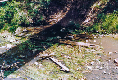
Photograph, Cross beam from old timber Main Road bridge over the Diamond Creek, 1992, 1992
... Cross beam from old timber Main Road bridge over the Diamond Creek, 1992...Old cross beam from original Main Road trestle bridge washed away in 1924 flood lying in creek bed. ...Two colour photographs of old cross beam from original Main Road trestle bridge lying in creek bed. It is downstream from the current re-structured bridge...It is downstream from the current re-structured bridge at time of photo. Unlikely to be present in 2026. bridges diamond creek main road eltham south Two colour photographs of old cross beam from original Main Road trestle bridge lying in creek bed. ...Old cross beam from original Main Road trestle bridge washed away in 1924 flood lying in creek bed. It is downstream from the current re-structured bridge at time of photo. Unlikely to be present in 2026.Two colour photographs of old cross beam from original Main Road trestle bridge lying in creek bed. It is downstream from the current re-structured bridgebridges, diamond creek, main road, eltham south -
 Melbourne Tram Museum
Photograph - Enlargement of a postcard, Bridge Road Richmond, c1900
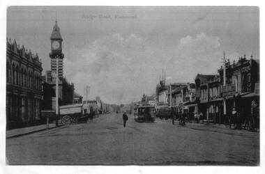
... Bridge Road Richmond...The first image shows the shops on either side of Bridge Road with horse drawn carts and one cable tram. ...Set of two A3 enlargements of postcards 1 - Looking east along Bridge Road from near Church St 2 - Bridge Road Richmond - from Town Hall looking west...Yields information about Bridge Road, c1900 Cable trams tramways Richmond Bridge Road Set of two A3 enlargements of postcards 1 - Looking east along Bridge Road from near Church St 2 - Bridge Road Richmond - from Town Hall looking west Bridge Road Richmond Photograph Enlargement of a postcard ...The first image shows the shops on either side of Bridge Road with horse drawn carts and one cable tram. The second image from the Town Hall tower, shows two cable tram sets, the narrowing of the road. Has in the view Guddon & Selleck Auction House and Property Exchange also advertising Commercial Union Assurance Co. and George Stirling and Sons store.Yields information about Bridge Road, c1900Set of two A3 enlargements of postcards 1 - Looking east along Bridge Road from near Church St 2 - Bridge Road Richmond - from Town Hall looking westcable trams, tramways, richmond, bridge road, -
 Hume City Civic Collection
Photograph, c 1980s
... The stone bridge was the only entry into Sunbury on the eastern side of the town and was in use until the road was re-routed and widened in the 1970s....The narrow asphalted surface of the road across the bridge is cut off by a low stone wall....Hume City Civic Collection 44 Macedon Street Sunbury melbourne The stone bridge was the only entry into Sunbury on the eastern side of the town and was in use until the road was re-routed and widened in the 1970s. stone bridges jacksons creek macedon street road bridge george evans collection A coloured photograph of the roadway over the Macedon Street bridge which spans Jacksons Creek. ...The stone bridge was the only entry into Sunbury on the eastern side of the town and was in use until the road was re-routed and widened in the 1970s.A coloured photograph of the roadway over the Macedon Street bridge which spans Jacksons Creek. There is a grassy area in the foreground with trees growing either side of the bridge. The narrow asphalted surface of the road across the bridge is cut off by a low stone wall.stone bridges, jacksons creek, macedon street road bridge, george evans collection -
 Eltham District Historical Society Inc
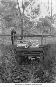
Photograph, The Rose Stereograph Company, Log Bridge, Eltham Road. Greensborough, c.1920
... Log Bridge, Eltham Road. Greensborough...The direction of the road based on shadows is northwest as is the Eltham Road to Greensborough (present day Sherbourne, Karingal and St Helena roads). ...Log Bridge, Eltham Road, Greensborough...The Cutts family understands that for these historically important pieces to rest with one family is to deny others the pleasure of their custodianship. eltham postcard travel rose stereograph company glass plate negative creek eltham road greensborough karingal road karingal yallock log bridge sherbourne road st helena road women's fashion rampton's road reserve Peter and Elizabeth Pidgeon Collection Log Bridge, Eltham Road, Greensborough Glass Plate Negative Size: 9.2 x 13.8 cm Log Bridge, Eltham Road. ...A woman stands at the end of a log bridge over a creek looking towards the south along the unsealed roadway. The sun illuminates her back. She is wearing a woollen knit beanie with edges rolled up, dark jacket and skirt, full length dark stockings and slip on dark leather shoes with raised heel, typical of the early 1920s. The creek is possibly feeding into the Karingal Yalloc. The direction of the road based on shadows is northwest as is the Eltham Road to Greensborough (present day Sherbourne, Karingal and St Helena roads). The creek is falling to the foreground so from south west to the north east, possibly feeding into the Karingal Yalloc, somewhere near presenet day Ramptons Road Reserve. This glass plate negative was used to manufacture postcards (1:1 printing) for commercial sale by the Rose Sterograph Company and its subsidiaries. George Rose founded the Rose Stereograph Company in 1880 and was joined by Herbert (Bert) Cutts in the early 20th Century. The pair formed a lifetime working partnership and strong personal friendship. Assisted by George’s two sons, Herbert George and Walter, and later by Neil Cutts, the Rose Stereograph Company continued its operations for more than 140 years. The company was initially built on stereographs, but as cinema took over and stereographs fell out of fashion, the Rose Stereograph Company developed Australia’s first commercially viable photographic postcard business. Specialising in postcards of iconic historical moments and significant landmarks, The Rose Stereograph Company became a staple of the Australian travel industry.This remarkable collection of glass plate negatives, transparencies, and postcards – arguably Australia’s most significant photography collection outside of public hands – has been passed down through the generations, surviving war, relocation, and the harsh Victorian climate. The historic Rose Stereograph collection is the culmination of George Rose’s dream of capturing and preserving precious moments in time and remains the legacy of the Rose and Cutts families. It is with great sadness that the Cutts family says goodbye to a collection that spans five generations and 140 years. The Cutts family understands that for these historically important pieces to rest with one family is to deny others the pleasure of their custodianship.Glass Plate Negative Size: 9.2 x 13.8 cmLog Bridge, Eltham Road, Greensborougheltham, postcard, travel, rose stereograph company, glass plate negative, creek, eltham road, greensborough, karingal road, karingal yallock, log bridge, sherbourne road, st helena road, women's fashion, rampton's road reserve, peter and elizabeth pidgeon collection -
 City of Whittlesea
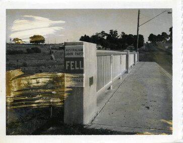
Photograph - Photographs - Bridges, Photograph - Bridge - Bundoora, 1967
... Bridge over Darebin Creek, Settlement Road Bundoora. ...Photographs, black and white print on paper. Bridge over Darebin Creek, Settlement Road Bundoora 1967. ...City of Whittlesea 25 Ferres Boulevard South Morang melbourne Bridge over Darebin Creek, Settlement Road Bundoora. ...Bridge over Darebin Creek, Settlement Road Bundoora. Looking west towards Thomastown, April 1967. Bridge post includes Australian Labor Party election poster for Greensborough Electorate. Bob Fell was the ALP candidate at the 1967 state election which he lost.Photographs, black and white print on paper. Bridge over Darebin Creek, Settlement Road Bundoora 1967. -
 Eltham District Historical Society Inc
Photograph, Construction of Lower Plenty Bridge, Main Road, c.August 1966, 1966
... Construction of Lower Plenty Bridge, Main Road, c.August 1966...Construction activity of a new Main Road bridge over the Plenty River at Lower Plenty in 1966. ...Black and white photograph taken during construction of the Main Road bridge over the Plenty River. Includes structural members, construction personnel, vehicles and a Clarke mobile crane....Local significance mobile cranes bridge construction main road plenty river lower plenty bridges Black and white photograph taken during construction of the Main Road bridge over the Plenty River. ...Construction activity of a new Main Road bridge over the Plenty River at Lower Plenty in 1966. The new bridge followed a realignment of the road and old Lower Plenty bridge remained in situ and is now part of the Plenty River Trail.Local significanceBlack and white photograph taken during construction of the Main Road bridge over the Plenty River. Includes structural members, construction personnel, vehicles and a Clarke mobile crane.mobile cranes, bridge construction, main road, plenty river, lower plenty, bridges -
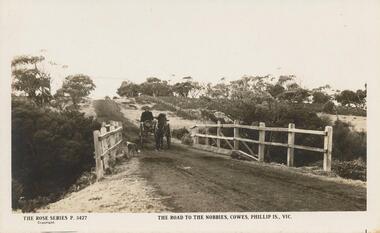 Phillip Island and District Historical Society Inc.
Sepia Photograph, 1920
... The photo is of the early road to the Nobbies. Horse and trap crossing the old bridge with a dog in the foreground....Sepia photograph of the road to The Nobbies showing horse and trap crossing old wooden bridge with a dog in the foreground....The photo is of the early road to the Nobbies. Horse and trap crossing the old bridge with a dog in the foreground. phillip island the nobbies wooden bridge earl of stradbroke Rose Series P 3427 The road to The Nobbies, Cowes, Phillip Is., Vic Sepia photograph of the road to The Nobbies showing horse and trap crossing old wooden bridge with a dog in the foreground. ...This album was presented to the Earl of Stradbroke by Fathers of Soldiers on Phillip Island. The photo is of the early road to the Nobbies. Horse and trap crossing the old bridge with a dog in the foreground.Sepia photograph of the road to The Nobbies showing horse and trap crossing old wooden bridge with a dog in the foreground.Rose Series P 3427 The road to The Nobbies, Cowes, Phillip Is., Vicphillip island, the nobbies, wooden bridge, earl of stradbroke