
Showing 11 items matching "selector's road"
-
 Mt Dandenong & District Historical Society Inc.
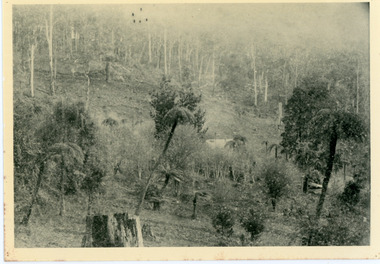
Photograph, Home of George Dodd at Olinda 1895, 1895
... ...Selector's Road...1895 picture of the home of George Dodd built c1880. Shows the Selector's Road made in the 1880s from Pig Lane in The Basin to the road in front of the Mt dandenong Hotel.The descriptive text on the reverse of this photograph was hand written by John Lundy-Clarke....1895 picture of the home of George Dodd built about 1880 showing the road the selectors made in the 1880s from Pig Lane to the main road in front of the present Mt Dandenong Hotel near the present end of the Basin-Olinda Road. ...George Dodd Dodd Mt Dandenong Hotel Selector's Road road Pig Lane 1895 picture of the home of George Dodd built about 1880 showing the road the selectors made in the 1880s from Pig Lane to the main road in front of the present Mt Dandenong Hotel near the present end of the Basin-Olinda Road. ...1895 picture of the home of George Dodd built c1880. Shows the Selector's Road made in the 1880s from Pig Lane in The Basin to the road in front of the Mt dandenong Hotel.The descriptive text on the reverse of this photograph was hand written by John Lundy-Clarke.1895 picture of the home of George Dodd built about 1880 showing the road the selectors made in the 1880s from Pig Lane to the main road in front of the present Mt Dandenong Hotel near the present end of the Basin-Olinda Road. It was never gazetted as a road as the Bruces objected to it and landslides in 1891 closed it temporarily and later landslides closed it permanently.george dodd, dodd, mt dandenong hotel, selector's road, road, pig lane -
 Flagstaff Hill Maritime Museum and Village
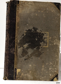
Book - Atlas, F.E. Hiscocks and Co, New Victorian Counties Atlas, 1874
... selectors" (smaller farmers taking up subdivided plots) began moving deep into rural Victoria. The atlas did not rely on guesswork; it utilized official colonial government data from the Registrar-General and the Mining Department. Today, environmental historians, genealogists, and legal researchers use this exact atlas to track land-use changes, the evolution of Victorian towns, environmental shifts in river systems, and the colonial dispossession and restructuring of the landscape. Flagstaff Hill Warrnambool Maritime Village Maritime Museum Shipwreck coast Great Ocean Road ...Published in Melbourne in 1874 by the prominent bookseller and publisher George Robertson, F.E. Hiscocks & Co.’s New Victorian Counties Atlas is a monumental 19th-century cartographic and statistical record of the colony of Victoria. While George Robertson was the publisher responsible for production, marketing, and distribution, the detailed compiling and surveying were executed by F.E. Hiscocks & Co., with the striking colour lithography handled by the renowned Melbourne firm Hamel & Ferguson.Hard cover book, New Victorian Counties Atlas Author: F.E. Hiscocks and Co, Publisher: George Robertson, Melbourne Vic. Date: 1874 Morocco Olive hardcover with a damaged black spine, reinforced corners to hardcover gold edging to where spine meets hardcover. Title in a lozenge on front cover edged with a decorative panel. non-fictionPublished in Melbourne in 1874 by the prominent bookseller and publisher George Robertson, F.E. Hiscocks & Co.’s New Victorian Counties Atlas is a monumental 19th-century cartographic and statistical record of the colony of Victoria. While George Robertson was the publisher responsible for production, marketing, and distribution, the detailed compiling and surveying were executed by F.E. Hiscocks & Co., with the striking colour lithography handled by the renowned Melbourne firm Hamel & Ferguson.flagstaff hill, warrnambool, maritime village, maritime museum, shipwreck coast, great ocean road, new victorian counties atlas, hiscocks and co, atlas, maps -
 Orbost & District Historical Society
outfit
... John Watt was an early selector who in 1879 selected land on the Marlo Road. She married Frank Edward Robertson on 4 March 1901 in Orbost....John Watt was an early selector who in 1879 selected land on the Marlo Road. She married Frank Edward Robertson on 4 March 1901 in Orbost. costume-women's lace Robertson Watt A black silk lace skirt and top. ...This outfit belonged to Ethel May Robertson (nee Watt) b: 1879 in Jindiwick, Victoria, Australia. She was the daughter of John Alexander Watt. John Watt was an early selector who in 1879 selected land on the Marlo Road. She married Frank Edward Robertson on 4 March 1901 in Orbost.A black silk lace skirt and top. It has a petticoat attached. There is a black scarf with a cameo brooch attached.costume-women's lace robertson watt -
 Orbost & District Historical Society
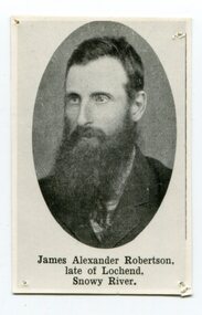
black and white photograph, 1884?
... selector on the Snowy River at Lochend. He took up Lots 1, 2 and 3, in the Parish of Newmerella in 1875; with his selection being ratified on May 1st, 1876. The selection included hill and river flat land in the area near where Icy Creek enters the Snowy River. James gradually improved and farmed the property; he cleared and drained Icy Creek and constructed the first known flood-gate on the Snowy River. To meet his farming commitments he supplemented his income by working on the construction and maintenance of roads...road cutting down Burn’s Hill at Newmerella. His tender was for £16 ($32), and it took him, with four others, two months to complete the contract. He was single, and, after his untimely death at aged 29, in 1884, his parents and surviving unmarried sisters and brothers moved from Sarsfield to take over his selection at Lochend. (more information Newsletter April 2013) James Robertson was the first selector ...James Alexander Robertson was born 14th June, 1855, at Pentridge. the Coburg area which was known as Pentridge at the time, and prior to the building of the gaol. His parents were James Thomson Robertson and Esther (nee Hale), At age 20 James became the first selector on the Snowy River at Lochend. He took up Lots 1, 2 and 3, in the Parish of Newmerella in 1875; with his selection being ratified on May 1st, 1876. The selection included hill and river flat land in the area near where Icy Creek enters the Snowy River. James gradually improved and farmed the property; he cleared and drained Icy Creek and constructed the first known flood-gate on the Snowy River. To meet his farming commitments he supplemented his income by working on the construction and maintenance of roads and drains in the Newmerella area. He gained a contract with the Bairnsdale Shire council to construct the first road cutting down Burn’s Hill at Newmerella. His tender was for £16 ($32), and it took him, with four others, two months to complete the contract. He was single, and, after his untimely death at aged 29, in 1884, his parents and surviving unmarried sisters and brothers moved from Sarsfield to take over his selection at Lochend. (more information Newsletter April 2013)James Robertson was the first selector of land at Lochend, Orbost.A small black / white portrait photograph, oval shaped with a white background. It is of a middle-aged man with a full beard and moustache.on front at bottom - typed in black -:"James Alexander Robertson, Late of Lochend, Snowy River"robertson-james-alexander lochend-robertson -
 Ringwood and District Historical Society
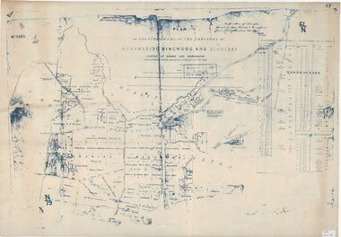
Map, Plan of Country Lands in the Parishes of Nunawading Ringwood and Scoresby - circa 1855
... Road. (*Cemetery did not eventuate.) Blueprint copy of Survey Map detailing original Selectors' names and property locations. ...Blueprint copy of Survey Map detailing original Selectors' names and property locations. List of Parish map references including property bearings, distances in Links, and markings on trees. Descriptive remarks include areas marked "Farmer's Common", "Poor soil thickly/moderately timbered with stringy bark", and location of water and firewood reserves."Surveyed and plotted by N.M. Bickford, Superintendant of Mr. Hodgkinson's Field Party". "The land comprised in this survey is of inferior quality, moderately undulating, and thickly wooded. It is watered by Dandenong Creek and Deep Creek." Inset map showing location of (*proposed) cemetery on southern corner of Lillydale Road from Melbourne and Sawmill Road, later Mount Dandenong Road. (*Cemetery did not eventuate.) -
 Ringwood and District Historical Society
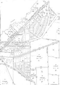
Map - Survey Plans, Township of East Ringwood, Victoria - circa 1870s - 1950s
... Includes Bedford Road and Illoura Avenue, Ringwood East. Photocopies of two 1878 Land Survey maps with names of early selectors and names and dates detailing subsequent land purchases to circa 1950s. ...Photocopies of two 1878 Land Survey maps with names of early selectors and names and dates detailing subsequent land purchases to circa 1950s. Third map (digitised copy only) "The East Estate by 1927" (from A South Australian Colonist of 1836 and His Descendants by Sir Ronald East - page 147). Includes Bedford Road and Illoura Avenue, Ringwood East. -
 Eltham District Historical Society Inc
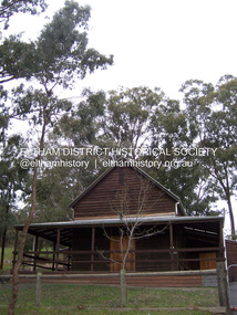
Photograph - Digital Photograph, Marguerite Marshall, Strathewen Public Hall, 20 August 2008
... Road. The first function was a Grand concert and Balll attended by about 120 people. Several denominations held Church services and Sunday School services in the Hall. It survived several bushfires until after this photo was taken when it was destroyed in Black Saturday, 9 February 2009. Published: Nillumbik Now and Then / Marguerite Marshall 2008; photographs Alan King with Marguerite Marshall.; p89 Strathewen was settled late, largely because it was difficult to access.1 Early selectors...Road. The first function was a Grand concert and Balll attended by about 120 people. Several denominations held Church services and Sunday School services in the Hall. It survived several bushfires until after this photo was taken when it was destroyed in Black Saturday, 9 February 2009. Published: Nillumbik Now and Then / Marguerite Marshall 2008; photographs Alan King with Marguerite Marshall.; p89 Strathewen was settled late, largely because it was difficult to access.1 Early selectors ...Strathewen Public Hall, social and spiritual centre was later lost in the Black Saturday fires 2009. The Strathewen Community decided a community hall was needed in 1901. In 1902 locals built the hall with messmate trees. It was located on the Cottlesbridge-Strathewen Road. The first function was a Grand concert and Balll attended by about 120 people. Several denominations held Church services and Sunday School services in the Hall. It survived several bushfires until after this photo was taken when it was destroyed in Black Saturday, 9 February 2009. Published: Nillumbik Now and Then / Marguerite Marshall 2008; photographs Alan King with Marguerite Marshall.; p89 Strathewen was settled late, largely because it was difficult to access.1 Early selectors found it a struggle to survive. They had to do everything themselves, from felling trees for buildings, to taking produce to market along bush tracks that they had helped cut. Small dairy farms were typical but fruit became the district’s prime produce. The first settlers east of Arthurs Creek were brothers John and Duncan Smith whose station Glen-Ard was probably operated as a sheep run. Other early settlers were the Mann family, who were to donate land for the hall, provide postal services and John Mann was an Eltham Shire councillor from 1916 to 1919.2 In 1873 James Mann, his wife Jane and their six children, settled on 207 acres (83.7) (Lang Fauld Farm) on both sides of Eagles Nest Road, from the foot of Mount Sugarloaf to the bank of the Arthurs Creek. In 1883 James took up another selection on Chads Creek. It was very hard work and at times he was well behind with his rent. However the family had a good social life, attending the Primitive Methodist Church at the Arthurs Creek Township and on New Year’s Eve throwing a party for all the locals. By 1874 James Mann’s younger brother, John, selected 311 acres (125.8ha) between Eagles Nest Road and upper Arthurs Creek. He called it Carseburn after his home parish in Scotland. Tragically in 1875 John drowned in the Yarra River, at Richmond.3 John Mann’s oldest son, also John, later purchased Duncan Smith’s land, which he named Violet Glen. He was to give one acre (0.4ha) of this land for the Strathewen Hall site. A Mann family diary written at Carseburn in 1897, tells how the district’s name was selected. Strathewen is derived from ‘strath’ meaning ‘broad mountain valley’ and from the name of Ewen H. Cameron, the local parliamentarian for almost 40 years. ‘George Brain came around to get a petition signed to get a post office up here and we had to vote for a name—Strathewen, Glen-Ard, or Headcorie’.4 It was at Carseburn that a public meeting in 1901, decided to build the Strathewen Hall on the Cottlesbridge-Strathewen Road. In 1902 the locals built the hall with messmate trees. The first function was a Grand Concert and Ball attended by around 120 people and several Protestant denominations took turns to hold church services and Sunday School there. Fortunately the hall has survived bushfires to be the town’s spiritual and social centre.5 The area continued to develop and in 1909 a post office operated somewhere at Strathewen and from around 1916 at Carseburn.6 It was not until 1914 that land was bought to establish the Strathewen State School on School Ridge Road. The residents paid £100 to build it on two acres (0.8 ha) while the Education Department contributed £30 and leased the building annually for £1. When teacher Miss Mary Golding opened the school in 1917, it had no equipment.7 But in 1921 the Education Department provided desks and a hexagonal shelter shed (now a rare style in Victoria) and took control in 1925.8 By 1917 Strathewen was booming.9 George Apted had built a coolstore in 1916, and local orchardists bought storage space until the 1950s. This allowed the area to supply the market in and out of season. Guesthouses catered for growing tourism. In the mid 1920s Mrs Eleanor Sparkes built the guest-house Singing Waters, which operated through the 1930s. Her daughter Mrs Vera McKimmie, ran it until the 1950s and the house remains in Chads Creek Road. In the Great Depression land was cleared for timber to be sold as firewood and there was small scale sawmilling. However the orchard industry diminished for several reasons including the 1939 bushfires and rapid changes in production methods. Today the Apteds still operate an orchard and farm at Glen-Ard, which straddles the border between Strathewen and Arthurs Creek. It includes the southern part of Duncan Smith’s original Glen-Ard selection.This collection of almost 130 photos about places and people within the Shire of Nillumbik, an urban and rural municipality in Melbourne's north, contributes to an understanding of the history of the Shire. Published in 2008 immediately prior to the Black Saturday bushfires of February 7, 2009, it documents sites that were impacted, and in some cases destroyed by the fires. It includes photographs taken especially for the publication, creating a unique time capsule representing the Shire in the early 21st century. It remains the most recent comprehenesive publication devoted to the Shire's history connecting local residents to the past. nillumbik now and then (marshall-king) collection, strathewan public hall -
 Eltham District Historical Society Inc
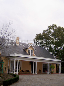
Photograph - Digital Photograph, Marguerite Marshall, 'Landscape', 60 Lavender Park Road, Eltham South, 24 June 2008
... Road Eltham was named Wiregrass in Leason’s honour. Leason completed 1000 drawings from 1919 to 1937, which author Garrie Hutchinson claimed, were technically unsurpassed and had regional and universal interest. Leason’s acute observations of country life stemmed from his childhood in Kaniva in Victoria’s western Wimmera, where he was born, the son of a selector, in 1889. ...Road Eltham was named Wiregrass in Leason’s honour. Leason completed 1000 drawings from 1919 to 1937, which author Garrie Hutchinson claimed, were technically unsurpassed and had regional and universal interest. Leason’s acute observations of country life stemmed from his childhood in Kaniva in Victoria’s western Wimmera, where he was born, the son of a selector, in 1889. ...Built by artist and cartoonist Percy Leason in 1927 in what was then New Street but renamed Lavender Park Road in the late 1950s/early 1960s. Covered under Heritage Overlay, Nillumbik Planning Scheme. Published: Nillumbik Now and Then / Marguerite Marshall 2008; photographs Alan King with Marguerite Marshall.; p121 Said to be a genius, cartoonist Percy Leason’s career was at its peak when in 1925 to 1926 he built his home at New Street (now Lavender Park Road) Eltham. The Herald newspaper owner, Sir Keith Murdoch, had hired Leason for his newly acquired Melbourne Punch magazine at a salary of £1750, making him ‘one of the highest paid cartoonists in the world’.1 With this salary and financial help from Murdoch, Leason was able to build his lovely home in Eltham. At the crest of a sweeping drive, the home now two-storey in white brick with a gabled grey slate roof and dormer windows is flanked by an extension built by another owner in the 1980s. Leason lived in the home with his wife, Isabel and children, until 1937, when he left for the United States of America, where he lived until his death in 1959. The four-bedroom house and garden would have been well-suited to bringing up his family and to entertaining their friends in style. Large airy rooms have high ceilings with moulded plaster, timber floors and several are brightened with bay windows. Leason made friends with many of the artists and personalities who gravitated to Eltham. Around 1931 Justus Jörgensen, founder of the Montsalvat Artists’ Colony, helped Leason build his large studio at the back of the house. Another friend was journalist Mervyn Skipper, father of jeweller and sculptor Matcham, and artists Helen and Sonia. Leason’s teacher, artist Max Meldrum, also visited and rented accommodation in Eltham, opposite Wingrove Park. Punch folded in 1925, but Leason continued as cartoonist for Table Talk. In 1926 Leason began the cartoons of a mythical Australian town Wiregrass, which were inspired by Kaniva, his home town. The art gallery in Main Road Eltham was named Wiregrass in Leason’s honour. Leason completed 1000 drawings from 1919 to 1937, which author Garrie Hutchinson claimed, were technically unsurpassed and had regional and universal interest. Leason’s acute observations of country life stemmed from his childhood in Kaniva in Victoria’s western Wimmera, where he was born, the son of a selector, in 1889. Meldrum claimed that Leason could name every plant and the habits of every animal.2 Leason also painted 28 portraits of the last full-blooded aboriginals in Victoria at Lake Tyers in Gippsland, most of which are in a private collection. In Sydney Leason illustrated Henry Lawson’s Selected Poems and worked for The Bulletin. Leason had begun his career at 13 as an apprentice lithographic artist at Sands and MacDougall. He attended night classes at the National Gallery and the Victorian Artists Society. Leason first visited Eltham in 1910 to paint with fellow artist William ‘Jock’ Frater. They camped near Bible and Pitt Streets and along the Diamond Creek on the site of the present Eltham Retirement Centre. Despite his success as a cartoonist, Leason wanted to be recognised as a serious painter and for his anthropological work.3 He was also conservative and felt uncomfortable with the modern art scene in Melbourne.4 So he left for the United States of America to work as a painter. Ironically his time in New York saw the burgeoning of modern art, notably by artists such as Jackson Pollock. But Leason found his niche by running an art school, painting society portraits and illustrating books and magazines.This collection of almost 130 photos about places and people within the Shire of Nillumbik, an urban and rural municipality in Melbourne's north, contributes to an understanding of the history of the Shire. Published in 2008 immediately prior to the Black Saturday bushfires of February 7, 2009, it documents sites that were impacted, and in some cases destroyed by the fires. It includes photographs taken especially for the publication, creating a unique time capsule representing the Shire in the early 21st century. It remains the most recent comprehenesive publication devoted to the Shire's history connecting local residents to the past. nillumbik now and then (marshall-king) collection, landscape, lavender park road, percy leason, new street -
 Sunshine and District Historical Society Incorporated
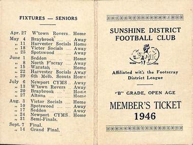
Ephemera - Sunshine District Football Club Members Ticket 1946 and Programme, 1946
... Sunshine District Football Club was affiliated with the Footscray Distict League B Grade Open Age|1 Members Ticket listing office bearers and fixtures for seniors President Mr J Downing JP Senior Vice President Mr J H Adams Vice Presidents Cr JR Parsons JP Cr RK McDonald JP Messrs CG Carlton JP E Drayton J Woods Committee Messrs C Howlett P Inkster E Hunter R Ferrell N Nielson E Nicholls Snr G Webb Joint Press Correspndents B Grade K Tisdale C Grade and General CM Utber Coach Mr Eric Huxtable Life Members Messrs J Chegwidden JH Adams J Woods Senior Selectors K Tisdale P Inkster E Hunter E Huxtable JH Adams Junior Selectors F Simpson C Missen C Utber N Nielson E Huxtable Auditors Messrs W Bell C Whiting Honorary Assistant Secretary K Tisdale Honorary Treasurer CJ Parsons Honorary Secretary CM Utber Located at 88 Hampshire Road Sunshine Phone MW9793| 2 Programme for social evening with autographs There is 26 autographs on back of programme...&D.H.S. through John Willaton Sunshine Football Club Football Sunshine District Football Club was affiliated with the Footscray Distict League B Grade Open Age|1 Members Ticket listing office bearers and fixtures for seniors President Mr J Downing JP Senior Vice President Mr J H Adams Vice Presidents Cr JR Parsons JP Cr RK McDonald JP Messrs CG Carlton JP E Drayton J Woods Committee Messrs C Howlett P Inkster E Hunter R Ferrell N Nielson E Nicholls Snr G Webb Joint Press Correspndents B Grade K Tisdale C Grade and General CM Utber Coach Mr Eric Huxtable Life Members Messrs J Chegwidden JH Adams J Woods Senior Selectors K Tisdale P Inkster E Hunter E Huxtable JH Adams Junior Selectors F Simpson C Missen C Utber N Nielson E Huxtable Auditors Messrs W Bell C Whiting Honorary Assistant Secretary K Tisdale Honorary Treasurer CJ Parsons Honorary Secretary CM Utber Located at 88 Hampshire Road Sunshine Phone MW9793| 2 Programme for social evening with autographs There is 26 autographs on back of programme Sunshine District Football Club Members Ticket 1946 and Programme with autographs on back of card Ephemera Sunshine District Football Club Members Ticket 1946 and Programme ...Donated to S.&D.H.S. through John WillatonSunshine District Football Club Members Ticket 1946 and Programme with autographs on back of cardSunshine District Football Club was affiliated with the Footscray Distict League B Grade Open Age|1 Members Ticket listing office bearers and fixtures for seniors President Mr J Downing JP Senior Vice President Mr J H Adams Vice Presidents Cr JR Parsons JP Cr RK McDonald JP Messrs CG Carlton JP E Drayton J Woods Committee Messrs C Howlett P Inkster E Hunter R Ferrell N Nielson E Nicholls Snr G Webb Joint Press Correspndents B Grade K Tisdale C Grade and General CM Utber Coach Mr Eric Huxtable Life Members Messrs J Chegwidden JH Adams J Woods Senior Selectors K Tisdale P Inkster E Hunter E Huxtable JH Adams Junior Selectors F Simpson C Missen C Utber N Nielson E Huxtable Auditors Messrs W Bell C Whiting Honorary Assistant Secretary K Tisdale Honorary Treasurer CJ Parsons Honorary Secretary CM Utber Located at 88 Hampshire Road Sunshine Phone MW9793| 2 Programme for social evening with autographs There is 26 autographs on back of programmesunshine football club, football -
 Tatura Irrigation & Wartime Camps Museum
Photographs, Alexander Stewart who lived at Gowrie Park
... Road, Tatura.|Alexander and Georgina Stewart sailed in 1859 from Mochrum, Scotland, arriving in Corio Bay. In 1872-73 they came to Tatura and selected near the town, being one of the early selectors. ...Road, Tatura.|Alexander and Georgina Stewart sailed in 1859 from Mochrum, Scotland, arriving in Corio Bay. In 1872-73 they came to Tatura and selected near the town, being one of the early selectors. ...GOWRIE PARK- Gowrie Park Road, Tatura.|Alexander and Georgina Stewart sailed in 1859 from Mochrum, Scotland, arriving in Corio Bay. In 1872-73 they came to Tatura and selected near the town, being one of the early selectors. The place was called Gowrie Park, still known by that name, and still in use as a dairy farm.|Before the Presbyterian Church was built in Tatura, all the services were held at Gowrie Park. The old dairy for keeping milk, cream and butter is still there today. Only two families have owned the property since the 1870®s, and the house has been beautifully renovated and extended.Photo 1: 15 x 11 cms. Photo 2: 10 x 6 cms. -
 Mont De Lancey
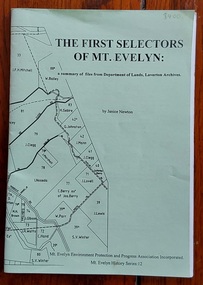
Book, Janice Newton, The First Selectors of Mt. Evelyn: a summary of files from the Department of Lands, Laverton Archives, 1996
... The wrap around paper cover is a photocopy of the redrawn Parish map of the Mt Evelyn post-code area with selectors' names, Lot numbers and some current roads and streets shown. ...The wrap around paper cover is a photocopy of the redrawn Parish map of the Mt Evelyn post-code area with selectors' names, Lot numbers and some current roads and streets shown. ...Janice Newton researched the early selectors through Lands Department files and has documented the history on the Mt Evelyn Community Website.A small green paperback book of the First Selectors of Mt. Evelyn who took up land after the 1869 Selection Acts - 1870 - 1890 with the land numbers. The information on the selections is listed alphabetically by name of listed selector. Some files were not found. The wrap around paper cover is a photocopy of the redrawn Parish map of the Mt Evelyn post-code area with selectors' names, Lot numbers and some current roads and streets shown. Inside the front cover is an explanation of the details within, a key to map lines, scale, and publishing details. pp.41.non-fictionJanice Newton researched the early selectors through Lands Department files and has documented the history on the Mt Evelyn Community Website.mt. evelyn - history, farms history, farming settlement, farming australia
