
Showing 84 items matching "street names - kew (vic)"
-
 Kew Historical Society Inc
Archive (Sub-series) - Subject File, Kew, Borough of - 1863-1911, 2012
... ...street names - kew (vic)...Typically files will contain primary and secondary sources. kew - history borough of kew streets - kew (vic) rates - kew (vic) street names - kew (vic) roads - kew (vic) drains - kew (vic) public health - kew (vic) inspector of nuisances - kew (vic) Kew was designated a borough in 1863 and remained so until declared a Town in 1911. ...Various partiesReferenceSecondary valuesKew was designated a borough in 1863 and remained so until declared a Town in 1911. The subject file contains copies of a research report by Andrew Frost on the work of Kew Council in this period in relation to the maintenance of streets.kew - history, borough of kew, streets - kew (vic), rates - kew (vic), street names - kew (vic), roads - kew (vic), drains - kew (vic), public health - kew (vic), inspector of nuisances - kew (vic)kew - history, borough of kew, streets - kew (vic), rates - kew (vic), street names - kew (vic), roads - kew (vic), drains - kew (vic), public health - kew (vic), inspector of nuisances - kew (vic) -
 Ruyton Girls' School
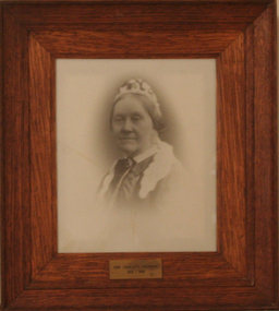
Photograph - Photographic Portrait, Mrs Charlotte Anderson
... named for Charlotte Anderson. Artwork AC/0099 is a framed reproduction photograph of an original portrait of Mrs Anderson, c.1900-1906. The location and date of the original photograph is unknown, but may be held among Ruyton papers at the State Library of Victoria (MS 12079). The reproduction was probably created to be part of the gallery of Principals and significant people for the Conference/Boardroom, Henty House. Charlotte Anderson Ruyton Ruyton Girls' School Kew (Vic) Bulleen Road High Street ...Mrs Charlotte Anderson was born Charlotte Eliza Alsop in England in 1838 and arrived in Australia in 1848. She married lawyer James Anderson in 1864, and in the year of his death in 1878 she became the founding owner-Principal of Ruyton Girls' School, Kew. Mrs Anderson operated Ruyton initially in her own home of 63 Bulleen Road, Kew (now 63 High Street South). According to Ruyton histories, Mrs Anderson is said to have begun the school with her own two sons, four daughters and some of her Alsop nieces and nephews who resided in Kew. Around the time of the addition of Maud King, the first student outside the family, the school changed to a 'Ladies College', and the boys were sent elsewhere for their education. By late 1881 Mrs Anderson began using the name 'Ruyton' for the school, in honour of a connection to Ruyton-XI-Towns, Shropshire, England where her great-grandfather had been vicar and where she was baptised. In 1882 Mrs Anderson moved the School to Edgecomb in Studley Park Road from 1882-1888. The larger premises enabled her to begin accepting boarding students from 1882. She retired due to ill health and sold the school to her friend Miss Eliza Bromby. Mrs Anderson lived at 'Bongamero', in the King Valley, Victoria until her death in 1906. She is buried in Boroondara Cemetery. One of Ruyton's four Houses, Anderson, is named for Charlotte Anderson. Artwork AC/0099 is a framed reproduction photograph of an original portrait of Mrs Anderson, c.1900-1906. The location and date of the original photograph is unknown, but may be held among Ruyton papers at the State Library of Victoria (MS 12079). The reproduction was probably created to be part of the gallery of Principals and significant people for the Conference/Boardroom, Henty House.A framed, black & white reproduction of a photographic portrait. The portrait shows the head and shoulders of a middle aged woman wearing Victorian-era clothing including a dark ribbon tied around her collar. She wears a lace cap on her head, and the cap's tail is draped around her shoulders. The woman's body is partially turned away from the camera, while her face is turned toward the camera. Plaque on frame: "Mrs Charlotte Anderson/ 1878-1888"charlotte anderson, ruyton, ruyton girls' school, kew (vic), bulleen road, high street south, studley park road, edgecomb, woman, school, teacher, principal, anderson, reproduction, 1990s -
 Kew Historical Society Inc
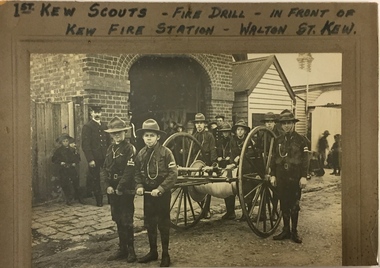
Photograph, 1st Kew Scouts Fire Drill, 1911, 1911
... Kew Fire Brigade building in Walton Street in 1911. The building, constructed in 1893 was later demolished in 1941. This is a rare historic photograph of the Station. Unfortunately the name of the photographer is unrecorded. kew fire brigade - walton street scout groups --- kew (vic) 1st kew boy scouts Front: "First Kew Scouts - Fire Drill - In front of Kew Fire Station - Walton St. ...A Volunteer Fire Brigade was established in Kew in 1879 and a fire station established in Walton Street, Kew. The Brigade was formally disbanded by the Fire Brigade Act of 1890 and the volunteers replaced by a unit of the Metropolitan Fire Brigade in 1891. The building shown in this rare photograph was constructed in 1893. In the background can be seen a house on the corner of Walton and Peel Streets, one of two, built in 1893 for firemen of the Brigade. An article in The Weekly Times (1 April 1911) records that: "Kew Troop - A,S.M. Williams reports:- The troop under S.M. Kellett. marched to the Kew Fire Brigade station, to receive instruction in fire drill from Mr Gross, the officer in charge, but as he was unexpectedly called away, the S.M. S and A.S.M had to instruct the Troop. Every boy was taught how to sink the hydrant, and how to couple and uncouple the hose. The hose reel was then brought into action, and the boys were divided into sets of six, each division taking its turn in pulling the reel up a hill to the water plug, where the hydrant was quickly sunk by one Scout, two more uncoupling the hose and coupling it on to the hydrant. We have gained four recruits during the last week, and are expecting two more next week."This is a fine, original photograph, probably taken by a commercial photographer, showing the 1st Kew Scouts in front of the old Kew Fire Brigade building in Walton Street in 1911. The building, constructed in 1893 was later demolished in 1941. This is a rare historic photograph of the Station. Unfortunately the name of the photographer is unrecorded.1st Kew Scouts undertaking a fire drill in front of the old Kew Fire Station in Walton Street, Kew. The reverse details the names and addresses of the Scouts featured in the photograph. An integral part of the Scout program is service to others and working with the fire brigade would have been just one of many such training activities enthusiastically undertaken by the Scouts. The Kew Fire Brigade had hand-drawn fire appliances up until 1919 when a motorised vehicle was purchased. The fire station was replaced by the Belford Road station in 1941 and subsequently demolished. Front: "First Kew Scouts - Fire Drill - In front of Kew Fire Station - Walton St. Kew" Reverse: "Walton St Kew / Kew Fire Station / Mr Gross o/c Fire Station / Bert Gundy Clark, part-time fireman / Allan Sewell Gellibrand St. / Clappy Williams Hawthorn ? / Allan Barrett Cobden St / Allan Woollard High St"kew fire brigade - walton street, scout groups --- kew (vic), 1st kew boy scouts -
 Kew Historical Society Inc
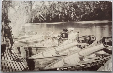
Postcard, Macauleys' Boat House, Kew, c.1900
... kew (vic) yarra river - kew (vic) Macauley's boat house -- boat shed "Lower Molesworth Street, 1900. Home restored still standing 1980." View of two women and two children in a canoe at Macauleys' Boat Shed at the end of Molesworth Street, Kew. At the left of the image stands a man and his dog, presumably the manager of the boat shed. On the bak of the seat of one of the canoes is its name ...The Kew Historical Society's Pictures Collection is comprised of photographs, postcards and original works of art. The postcards include original (mainly) images dating from the 1900s to the present. A number of postcards, some of which have numerous variants, were published as parts of series. Others are original images customised as postcards. Many of the postcards in the collection depict places within the suburbs of Kew and Kew East. Others depict locations in Victoria or internationally.View of two women and two children in a canoe at Macauleys' Boat Shed at the end of Molesworth Street, Kew. At the left of the image stands a man and his dog, presumably the manager of the boat shed. On the bak of the seat of one of the canoes is its name - sunbeam. Another item in the collection includes one of these name boards."Lower Molesworth Street, 1900. Home restored still standing 1980."postcards, recreation - yarra river - kew (vic), yarra river - kew (vic), macauley's boat house -- boat shed -
 Kew Historical Society Inc
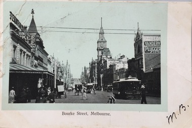
Postcard, Bourke Street, Melbourne, 1920-1920
... name of the publisher or printer. A number of the cards were published as parts of popular series. A way of dating early postcards is to identify whether the reverse was divided by a central line which became the norm after 1902 in the United Kingdom. However, other postcards produced after this date do not always conform to this print layout. bourke street - melbourne postcards -- melbourne (vic) photographic postcards Mrs L. Clark, Ecclesbourne, Harp Road, East Kew ...The Kew Historical Society's postcard collection includes views of Kew, Melbourne and Greater Melbourne as well as those including overseas scenes sent or received from Europe or the Middle East. They date from the 1890s to the 2000s. These postcards may or may not include the name of the publisher or printer. A number of the cards were published as parts of popular series. A way of dating early postcards is to identify whether the reverse was divided by a central line which became the norm after 1902 in the United Kingdom. However, other postcards produced after this date do not always conform to this print layout.Monochrome postcard of Bourke Street, Melbourne, looking west from Swanston Street. The costumes of the women in the photograph would indicate the use of an earlier photograph dating from the 1885-1895.Mrs L. Clark, Ecclesbourne, Harp Road, East Kew / Wishing you many happy returns of the Day, M. Boylebourke street - melbourne, postcards -- melbourne (vic), photographic postcards -
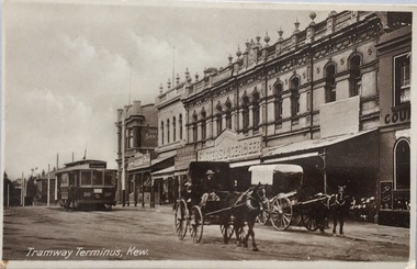 Kew Historical Society Inc
Postcard, Oastler (Leading Stationer), Tramway Terminus, Kew, c.1913
... name of the publisher or printer. A number of the cards were published as parts of popular series. A way of dating early postcards is to identify whether the reverse was divided by a central line which became the norm after 1902 in the United Kingdom. However, other postcards produced after this date do not always conform to this print layout. postcards -- kew (vic.) trams -- kew (vic.) Cotham Road -- high street ...The Kew Historical Society's postcard collection includes views of Kew, Melbourne and Greater Melbourne as well as those including overseas scenes sent or received from Europe or the Middle East. They date from the 1890s to the 2000s. These postcards may or may not include the name of the publisher or printer. A number of the cards were published as parts of popular series. A way of dating early postcards is to identify whether the reverse was divided by a central line which became the norm after 1902 in the United Kingdom. However, other postcards produced after this date do not always conform to this print layout.A monochrome postcard of the tram terminus beside 'The Block' in Cotham Road, KewOastler, leading stationer, Kew / Printed in Saxonypostcards -- kew (vic.), trams -- kew (vic.), cotham road -- high street --- kew (vic.), the block -- cotham road -- kew (vic.) -
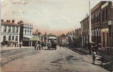 Kew Historical Society Inc
Postcard, High Str., Kew, c.1906
... name of the publisher or printer. A number of the cards were published as parts of popular series. A way of dating early postcards is to identify whether the reverse was divided by a central line which became the norm after 1902 in the United Kingdom. However, other postcards produced after this date do not always conform to this print layout. High Street -- Kew (vic ...The Kew Historical Society's postcard collection includes views of Kew, Melbourne and Greater Melbourne as well as those including overseas scenes sent or received from Europe or the Middle East. They date from the 1890s to the 2000s. These postcards may or may not include the name of the publisher or printer. A number of the cards were published as parts of popular series. A way of dating early postcards is to identify whether the reverse was divided by a central line which became the norm after 1902 in the United Kingdom. However, other postcards produced after this date do not always conform to this print layout.Polychrome postcard of High Street, Kew looking west towards Kew Junction. The photograph was also printed in monochrome format by the publishers, with different names and additions.Reverse - (to) Miss __. J. Thompson, "Dry Lake", Kerang (from) Very sorry indeed to hear of your Mother's illness. Sincerely hope all quite well ere this. Still going about very tired waiting __ being away. Love to all M.B.L.high street -- kew (vic.), postcards -- kew (vic.), horse tram -- kew (vic.) -
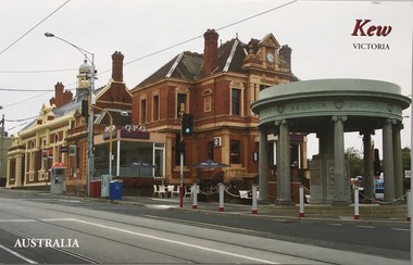 Kew Historical Society Inc
Postcard, Margie McKenzie Photography, Kew Victoria, Australia, c.2010
... Kew, Melbourne and Greater Melbourne as well as those including overseas scenes sent or received from Europe or the Middle East. They date from the 1890s to the 2000s. These postcards may or may not include the name of the publisher or printer. A number of the cards were published as parts of popular series. qpo restaurant, kew post office, kew court house, kew war memorial postcards -- kew (vic.) QPO Bar, Restuarant & Function Centre/ Cnr High Street ...The Kew Historical Society's postcard collection includes views of Kew, Melbourne and Greater Melbourne as well as those including overseas scenes sent or received from Europe or the Middle East. They date from the 1890s to the 2000s. These postcards may or may not include the name of the publisher or printer. A number of the cards were published as parts of popular series. Modern photographic postcard of the QPO Restaurant and the former Kew Court House. At the front of the restaurant is the Kew War Memorial, the drum of which at this stage was incorrectly painted a shade of green, which the Council later changed after representations from the Kew Historical Society and a heritage report.QPO Bar, Restuarant & Function Centre/ Cnr High Street & Cotham Rd. Mel Ref 45 C6 MacKenzie photography / Copyright margiesphotos.com.auqpo restaurant, kew post office, kew court house, kew war memorial, postcards -- kew (vic.) -
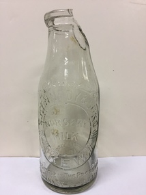 Kew Historical Society Inc
Container - Milk Bottle, Nursery Milk Bottle : Kennedy & Sons, Kew, Twentieth century
... (The Argus, 11 July 1930) Rare, if damaged milk bottle from an historic Kew dairy kennedy's dairy kennedy and sons dairies - kew (vic) milk bottles - kew - melbourne - victoria thomas kennedy michael kennedy "Kennedy & Sons / Kew / Nursery Milk / This bottle is the property of T.Kennedy & Sons, Kew/ and cannot be legally used by others." Milk bottle produced for and retailed by Kennedy & Sons Kew. The dairy operated under various names, and at one stage was described as the Rose Lea Dairy. The dairy was situated on the corner of Eglinton and Pakington Streets ...Kennedy and sons, Roselea Dairy operated in Kew (<1930-1945>). In 1945 Thomas Kennedy, Michael Kennedy and Patrick John Kennedy traded as Kennedy and sons, Roselea Dairy at 80 Pakington St, Kew. (Victorian Government, 07 December 1945). Tom Kennedy, Jnr, and his wife, Lucy, lived at 109 Pakington St Kew. Tom Kennedy Jnr. died 02 November 1963. Lucy Kennedy died 28 November 1987. "CONTEMPT OF COURT. MILK-CARTER GUILTY. Breach of an Injunction. A Supreme Court writ has been issued by Thomas Kennedy, sen., Thomas Kennedy, jun., Patrick John Kennedy, and Michael Kennedy, trading as Kennedy and Sons, Rose Lea Dairy, against Gordon Allberry Shepherdly, of Barnard street, North Kew, milk-carter, claiming an injunction and damages. Plaintiffs carry on business at Pakington street. Kew, and Melville street, Hawthorn, and they claim In their writ an injunction restraining the defendant from soliciting or endeavouring to obtain the custom of people who were customers of plaintiffs when Shepherdly was employed by them under an agreement dated March 13 1928. Plaintiffs also claim damages. Mr Read (instructed by Messrs. Moule, Hamilton, and Derham) appeared for plaintiffs before Mr. Justice Macfarlan in the Practice Court yesterday, to ask for an order for the committal of Shepherdly to prison, or alternatively, for an order that plaintiffs be at liberty to Issue a writ of attachment against him for contempt of court in soliciting or endeavouring to obtain the custom of plaintiffs' customers. The affidavits set out that Shepherdly was employed by plaintiffs from March I3, 1928. until June 6. 1930. An Interlocutory injunction had been granted pending trial of the action for a permanent injunction. Shepherdly, who appeared in person yesterday, said that he had a sick wife and two children. He had not served any of the customers referred to since the granting of the injunction. He had passed them over to another man for whom he was working. Mr Justice Macfarlan - In doing that you have committed a breach of the injunction, and I have no alternative but to order that you be sent to gaol. I will make an order that you be committed to prison until further order of the Court. I will direct, however, that the order be not executed until Tuesday next. If you can then satisfy the Court that you have ceased to serve, or take any part in serving, the customers of Kennedy and Sons, the order will not be executed. (The Argus, 11 July 1930) Rare, if damaged milk bottle from an historic Kew dairyMilk bottle produced for and retailed by Kennedy & Sons Kew. The dairy operated under various names, and at one stage was described as the Rose Lea Dairy. The dairy was situated on the corner of Eglinton and Pakington Streets, Kew. "Kennedy & Sons / Kew / Nursery Milk / This bottle is the property of T.Kennedy & Sons, Kew/ and cannot be legally used by others."kennedy's dairy, kennedy and sons, dairies - kew (vic), milk bottles - kew - melbourne - victoria, thomas kennedy, michael kennedy -
 Kew Historical Society Inc
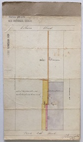
Plan, Survey Plan, Park Hill Road, Kew, 1880-1890
... Kew from 1866. The unnamed survey plan includes names of land owners in addition to measurements (2 chains to 1 inch) and streets. Named owners include Webster, Payne and Francom which will enable us to narrow down the creation date of the survey. Handdrawn survey plan by a former surveyor and town clerk of Kew surveys - kew, maps - kew, holland loxton, park hill road - kew Holland Loxton -- Surveyor Survey plans -- Parkhill Road -- Kew (Vic.) ...The streets identified on the survey plan - Cotham Road, Park Hill Road East, Park Hill Road West in Kew were each gazetted by the Victorian Government in 1865. The hand-coloured survey plan was completed by Holland Loxton, Town Clerk and Surveyor of the Borough of Kew from 1866. The unnamed survey plan includes names of land owners in addition to measurements (2 chains to 1 inch) and streets. Named owners include Webster, Payne and Francom which will enable us to narrow down the creation date of the survey.Handdrawn survey plan by a former surveyor and town clerk of KewHand drawn and coloured survey plan created by Holland Loxton, Surveyor and Town Clerk of Kew, showing land owned by Payne in Park Hill Road, Kew. The plan includes street names, land measurements and land owners.surveys - kew, maps - kew, holland loxton, park hill road - kew, holland loxton -- surveyor, survey plans -- parkhill road -- kew (vic.) -
 Kew Historical Society Inc
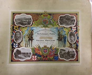
Document - Invitation to a Royal Review at Flemington, Sands & McDougall Ltd, 1901
... street -- kew (vic.) Printed: AUSTRALIAN COMMONWEALTH CELEBRATIONS/ The Government of Victoria/ requests the honour of the presence of/ [name deleted] / AT THE/ ROYAL REVIEW/ at Flemington on Friday/ the 10th of May 1901. ...The correspondent of The Argus recorded that: "The Parliament of the Commonwealth was opened yesterday by the Duke, of Cornwall and York, under a Commission signed by Queen Victoria and subsequently endorsed by King Edward VII. The ceremony was marked by the splendour and solemn impressiveness which befitted its historic importance. ... To-day the Heir to the Throne will review some 15,000 Australian troops at Flemington. ... It is a function which, on a lesser scale, might have been arranged at any time for many years past; but it could never previously have conveyed the meaning it does now. Soldiering was popularly regarded as a pastime here until South Africa tried the mettle of our men. It is serious business from henceforth. Those who followed the nascent aspirations of the volunteer soldiery in Australia must be impressed at the rapidity of their fulfillment. ... The document design has artistic and aesthetic merit. While it is not rare, it is representative of the kinds of formal designs used for the Australian Commonwealth celebrations at the time of Federation, and is in excellent condition. Such items as this invitation have local, state and national historic significance as mementoes of a key moment in Australia's history. Locally, the invitation is part of a group of Federation-related items owned and displayed at 'Fairyland' by Mrs Grace Tabulo, and a rare survivor of that collection.An invitation, mounted on card to the Royal Review held at Flemington racecourse on Friday 10 May 1901, as part of the Government of Victoria's Australian Commonwealth Celebrations. The border is vividly decorated with flags, shields and a large coat of arms. The photographic images depict various scenes of Flemington in Melbourne, in addition to two separate portraits of the Duke and Duchess of Cornwall and York. Illustrations of military servicemen on foot and horseback flank the central block of text. The invitation was part of the 'Fairyland Collection assembled by Jim and Grace Tabulo. The name on the certificate was expunged.Printed: AUSTRALIAN COMMONWEALTH CELEBRATIONS/ The Government of Victoria/ requests the honour of the presence of/ [name deleted] / AT THE/ ROYAL REVIEW/ at Flemington on Friday/ the 10th of May 1901. Reverse: Mrs G. Tabulo, 57 Malmsbury St.federation events, royal review - 1901, federation -- invitations, grace tabulo -- fairyland -- 57 malmsbury street -- kew (vic.) -
 Kew Historical Society Inc
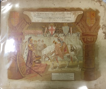
Document, Sands & McDougall Ltd, Invitation to a ‘Conversazione’ in the Exhibition Building, 1901
... Locally, the invitation is part of a group of Federation-related items owned and displayed by Mrs Grace Tabulo, the owner of 'Fairyland', 57 Malmsbury Street, Kew. sands & mcdougall ltd documents - invitations first commonwealth parliament 1901 grace tabulo -- fairyland -- 57 malmsbury street -- kew (vic.) Printed front: UNITED AUSTRALIA 1901 / ONE FLAG / ONE HOPE / ONE DESTINY; AUSTRALIAN COMMONWEALTH CELEBRATIONS / THE GOVERNMENT OF VICTORIA requests the honour of the presence of / [name deleted] / at a Conversazione in the Exhibition Building on the Evening of Tuesday 7th May 1901 at 8 P.M. ...A report in the Ballarat Star on 8 May 1901 recorded that: "THE CONVERSAZIONE. A GREAT SUCCESS. The conversazion given by the Government of Victoria at the Exhibition was very largely patronised. the guests includ ing the Prime Minister and a goodly proportion of the distinguished personages now in Melbourne. A programme of high-class music was gone through, and refreshments were served during the evening. Australian wines were very prominent."The document design has artistic and aesthetic merit. While it is not rare, it is representative of the kinds of formal designs used for the Australian Commonwealth celebrations at the time of Federation, and is in excellent condition. Such items as this invitation have local, state and national historic significance as mementoes of a key moment in Australia's history. Locally, the invitation is part of a group of Federation-related items owned and displayed by Mrs Grace Tabulo, the owner of 'Fairyland', 57 Malmsbury Street, Kew.Colour lithograph mounted on card to an evening event, a conversazione, held in the Exhibition Building on the evening of Tuesday 7th May 1901, as part of the Australian Commonwealth Celebrations. The Government of Victoria hosted the event. The invitation shows an etching of the Exhibition Building, surrounded by an ornate border of heraldic shields, portraits of the Duke and Duchess, views of Perth, Adelaide, Melbourne, Sydney, Brisbane and Hobart, and native flora (including wattle, waratah, pink heath, Sturt’s desert pea, and flannel flower), and native fauna (kookaburra, possum, lyre bird, cockatoo and koala). The royal crest ‘Dieu et mon droit’ and the Australian crest, ‘Advance Australia’ are also included.Printed front: UNITED AUSTRALIA 1901 / ONE FLAG / ONE HOPE / ONE DESTINY; AUSTRALIAN COMMONWEALTH CELEBRATIONS / THE GOVERNMENT OF VICTORIA requests the honour of the presence of / [name deleted] / at a Conversazione in the Exhibition Building on the Evening of Tuesday 7th May 1901 at 8 P.M. Reverse [handwritten]: Mrs G. Tabulo, 57 Malmsbury St.sands & mcdougall ltd, documents - invitations, first commonwealth parliament 1901, grace tabulo -- fairyland -- 57 malmsbury street -- kew (vic.) -
 Kew Historical Society Inc
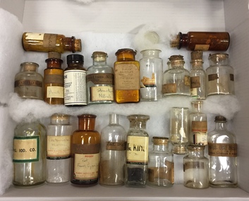
Functional object - Pharmaceutical Collection, Apothecary Jars and Sundry Bottles, c.1886 - c.1950s
... names of a number of pharmacists who ran the dispensary. Of these 34 held pharmaceuticals, 8 food or drink, and 5 miscellaneous. The Brenda and Bob Johnson collection represents an important continuous historical record of pharmaceutical and commercial practice in Victoria in the 19th and 20th centuries. Many of the items warrant additional research. The Kew Historical Society is seeking a suitably qualified and interested researcher to audit, describe and evaluate the collection. chemist supplies pharmaceutical items dispensary books fga barnard brenda johnson francis barnard 167 high street - kew (vic ...The Brenda and Bob Johnston Collection is comprised of 19th and 20th century pharmaceutical records, books, apothecary jars and pharmaceutical implements. The items in the collection were used and or available for sale by chemists who occupied 167 High Street, beginning with Francis Barnard. The most important items in the collection are two dispensary books, one from the 1880s and the other from the start of the 20th century. Both were owned and compiled by Francis and his son FGA Barnard. The collection was donated to the Kew Historical Society over a number of years. The most recent donation by Brenda Johnson includes approximately 50 bottles labelled with the names of a number of pharmacists who ran the dispensary. Of these 34 held pharmaceuticals, 8 food or drink, and 5 miscellaneous.The Brenda and Bob Johnson collection represents an important continuous historical record of pharmaceutical and commercial practice in Victoria in the 19th and 20th centuries. Many of the items warrant additional research. The Kew Historical Society is seeking a suitably qualified and interested researcher to audit, describe and evaluate the collection.A collection of approximately 50 bottles labelled with the names of a number of pharmacists who ran the dispensary started by Francis Barnard in High Street, Kew. Of these 34 held pharmaceuticals, 8 food or drink, and 5 miscellaneous.Various labelschemist supplies, pharmaceutical items, dispensary books, fga barnard, brenda johnson, francis barnard, 167 high street - kew (vic), apothecary jars, medicines & health -
 Kew Historical Society Inc
Award, V.B.A, President’s Trophy, 1937
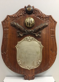
... The collection illuminates two of the Victorian historic themes - 'Building community life' through forming community organisations and 'Shaping cultural and creative life' by participating in sport and recreation. kew bowling club - wellington street - kew (vic) clubs - lawn bowls - kew (vic) trophies - lawn bowls VBA / VICTORIA BOWLING ASSOCIATION / PRESIDENT'S TROPHY / PRESENTED BY *** SIR WM BRUNTON / WON BY KEW BOWLING CLUB / TEAMS / JP CUMMINS, LH HAMBLETON, CG WOOD, P VANCE, / AD TAYLOR, RLR TROON, HE FRASER, FH RIGG Wood, brass and white metal VBA President's trophy. While the names ...Sports Clubs in Kew in the final decades of the 19th century and in the early 20th century were often umbrella organisations with facilities for a number of sports. Typically in Kew, this included teams in lawn bowls, tennis and croquet. The Kew Bowling Club was formed in 1880 while the privately owned Auburn Heights Recreation Club was opened in 1904. By 1998, the two Clubs decided to amalgamate at the Auburn Heights site in Barkers Road, forming the Kew Heights Sports Club. The combined club was itself taken over by the Melbourne Cricket Club in 2012 becoming MCC Kew Sports Club. In 2017 MCC Kew closed and its landholding was subsequently sold to Carey Baptist Grammar School. Both the Kew and Auburn Heights Clubs assembled important collections. These historically significant and large collections were donated to the Society in 2020. The collections include manuscripts, pictures, trophies, plans, honour boards etc. References Barnard FGA 1910, 'Sports and Pastimes' in Jubilee History of Kew Victoria: Its origin & progress 1803-1910. Nixon NV 1980, The History of the Kew Bowling Club 1880-1980. Reeve S 2012, City of Boroondara: Thematic Environmental History, p.216.The combined collections of the four sporting clubs making up the collection number hundreds of items that are historically significant locally. They are also significant to the sporting history of the greater Melbourne area and to the sports of lawn bowls and tennis in Australia in the 19th and 20th centuries. The collection illuminates two of the Victorian historic themes - 'Building community life' through forming community organisations and 'Shaping cultural and creative life' by participating in sport and recreation.Wood, brass and white metal VBA President's trophy. While the names of the winners have been partially abraided, contemporary press reports confirm the details and the significance of the trophy. An article in The Australasian (30 Jan 1937 reports: V.B.A. OFFICIALS' TROPHIES The three competitions involved in this title have now been concluded. Commenced on December 12, they occupied two Saturdays, and then were played on Tuesday afternoons to the conclusion. The president's trophy - the oldest competition in bowls, dating back to 1873 is for a two-rInk team of A pennant players; while the vice-president's B trophy and the vice-president's C trophy are also confined to two-rink teams in their respective grades. In the semi-final ot the president's trophy Kew, 34, defeated Richmond Union, 23, and Oakleigh defeated City of Hawthorn by 45-35. In the final Kew defeated Oakleigh, the scores being Kew, 39 (Cummins, Hambleton, Wood, Vance, 14; Taylor, Troon, Fraser, Rigg, 25), and Oakleigh. 20 (Cameron, Sumsion, Gronow, Walker, 12; Emmett, Skjellerup, Pakes, Geggie, 8). Kew had to wait 35 years to win its second president's trophy. That club was runner-up in 1890. Oakleigh has been twice runner-up (in 1924 and 1937), but has never won it. [The item is part of the historic Kew Bowling Club collection (1880-1988) gifted to the Kew Historical Society in 2020].VBA / VICTORIA BOWLING ASSOCIATION / PRESIDENT'S TROPHY / PRESENTED BY *** SIR WM BRUNTON / WON BY KEW BOWLING CLUB / TEAMS / JP CUMMINS, LH HAMBLETON, CG WOOD, P VANCE, / AD TAYLOR, RLR TROON, HE FRASER, FH RIGGkew bowling club - wellington street - kew (vic), clubs - lawn bowls - kew (vic), trophies - lawn bowls -
 Kew Historical Society Inc
Newspaper - Newspaper Article, Kew's Great Loss, 27/06/1924
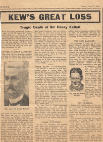
... Street, East Kew. In 1884, Henry Kellett was elected to the Kew Borough Council and served for 40 years; a remarkable example of public service. He was elected Mayor for a single term in 1888-9. Sir Henry de Castres Kellett died in St George’s Hospital in 1924 following a tragic car accident in Cotham Road, Kew while on Council business. The vehicle, in which he was travelling with fellow councillors and the Town Clerk, collided with a tram. Sir Henry Kellett is commemorated in the naming of Kellett Reserve and Kellett Grove. Mayors of kew (vic ...Sir Henry de Castres Kellett (1851-1924) the son of a hereditary baronet, was born at Mt Gambier, South Australia in 1851. His English title had been created in Ireland in 1801, but the family was originally Norman with the later branches living in England and Ireland. Sir Henry Kellett assumed the title in 1906. Henry Kellett was a prominent Kew retailer, continuing his father’s newspaper and stationery business in Bulleen Road (now High Street). At various stages, he also acted as an insurance, postal and real estate agent. He lived in Walpole Street and later at Lota Begg (now demolished) in Westbrook Street, East Kew. In 1884, Henry Kellett was elected to the Kew Borough Council and served for 40 years; a remarkable example of public service. He was elected Mayor for a single term in 1888-9. Sir Henry de Castres Kellett died in St George’s Hospital in 1924 following a tragic car accident in Cotham Road, Kew while on Council business. The vehicle, in which he was travelling with fellow councillors and the Town Clerk, collided with a tram. Sir Henry Kellett is commemorated in the naming of Kellett Reserve and Kellett Grove.Newspaper report in The Sentinel reporting the death of Cr Sir Henry Kellett in 1924mayors of kew (vic), sir henry de castres kellett -
 Kew Historical Society Inc
Certificate - Certificate of Marriage, Henry de Castres Kellett & Joan Harrison, 1880, 09/11/1880
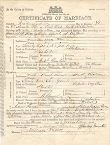
... Street, East Kew. In 1884, Henry Kellett was elected to the Kew Borough Council and served for 40 years; a remarkable example of public service. He was elected Mayor for a single term in 1888-9. Sir Henry de Castres Kellett died in St George’s Hospital in 1924 following a tragic car accident in Cotham Road, Kew while on Council business. The vehicle, in which he was travelling with fellow councillors and the Town Clerk, collided with a tram. Sir Henry Kellett is commemorated in the naming of Kellett Reserve and Kellett Grove. mayors of kew (vic ...Sir Henry de Castres Kellett (1851-1924) the son of a hereditary baronet, was born at Mt Gambier, South Australia in 1851. His English title had been created in Ireland in 1801, but the family was originally Norman with the later branches living in England and Ireland. Sir Henry Kellett assumed the title in 1906. Henry Kellett was a prominent Kew retailer, continuing his father’s newspaper and stationery business in Bulleen Road (now High Street). At various stages, he also acted as an insurance, postal and real estate agent. He lived in Walpole Street and later at Lota Begg (now demolished) in Westbrook Street, East Kew. In 1884, Henry Kellett was elected to the Kew Borough Council and served for 40 years; a remarkable example of public service. He was elected Mayor for a single term in 1888-9. Sir Henry de Castres Kellett died in St George’s Hospital in 1924 following a tragic car accident in Cotham Road, Kew while on Council business. The vehicle, in which he was travelling with fellow councillors and the Town Clerk, collided with a tram. Sir Henry Kellett is commemorated in the naming of Kellett Reserve and Kellett Grove.Original Marriage Certificate of Henry de Castres Kellet and Joan Harrosn, in Richmond on 9 November 1880mayors of kew (vic), sir henry de castres kellett -
 Kew Historical Society Inc
Letter - Letter of Condolence, Lady Kellett, Lota Begg, Westbrook Street, Kew, 1924
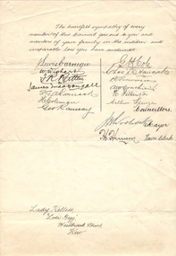
... Kew while on Council business. The vehicle, in which he was travelling with fellow councillors and the Town Clerk, collided with a tram. Sir Henry Kellett is commemorated in the naming of Kellett Reserve and Kellett Grove. Original official document from a noted event in Kew's history mayors of kew (vic) sir henry de castres kellett One page undated, handwritten letter of condolence to Lady Kellett on her husband's accidental death in 1924 while serving as a Kew Councillor. The latter is signed by his fellow councillors, the Mayor and the Town Clerk Lady Kellett, Lota Begg, Westbrook Street ...Sir Henry de Castres Kellett (1851-1924) the son of a hereditary baronet, was born at Mt Gambier, South Australia in 1851. His English title had been created in Ireland in 1801, but the family was originally Norman with the later branches living in England and Ireland. Sir Henry Kellett assumed the title in 1906. Henry Kellett was a prominent Kew retailer, continuing his father’s newspaper and stationery business in Bulleen Road (now High Street). At various stages, he also acted as an insurance, postal and real estate agent. He lived in Walpole Street and later at Lota Begg (now demolished) in Westbrook Street, East Kew. In 1884, Henry Kellett was elected to the Kew Borough Council and served for 40 years; a remarkable example of public service. He was elected Mayor for a single term in 1888-9. Sir Henry de Castres Kellett died in St George’s Hospital in 1924 following a tragic car accident in Cotham Road, Kew while on Council business. The vehicle, in which he was travelling with fellow councillors and the Town Clerk, collided with a tram. Sir Henry Kellett is commemorated in the naming of Kellett Reserve and Kellett Grove.Original official document from a noted event in Kew's historyOne page undated, handwritten letter of condolence to Lady Kellett on her husband's accidental death in 1924 while serving as a Kew Councillor. The latter is signed by his fellow councillors, the Mayor and the Town Clerkmayors of kew (vic), sir henry de castres kellett -
 Kew Historical Society Inc
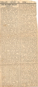
Newspaper - Newspaper Article, Late Sir Henry Kellett, 1924, 1924
... Street, East Kew. In 1884, Henry Kellett was elected to the Kew Borough Council and served for 40 years; a remarkable example of public service. He was elected Mayor for a single term in 1888-9. Sir Henry de Castres Kellett died in St George’s Hospital in 1924 following a tragic car accident in Cotham Road, Kew while on Council business. The vehicle, in which he was travelling with fellow councillors and the Town Clerk, collided with a tram. Sir Henry Kellett is commemorated in the naming of Kellett Reserve and Kellett Grove. mayors of kew (vic ...Sir Henry de Castres Kellett (1851-1924) the son of a hereditary baronet, was born at Mt Gambier, South Australia in 1851. His English title had been created in Ireland in 1801, but the family was originally Norman with the later branches living in England and Ireland. Sir Henry Kellett assumed the title in 1906. Henry Kellett was a prominent Kew retailer, continuing his father’s newspaper and stationery business in Bulleen Road (now High Street). At various stages, he also acted as an insurance, postal and real estate agent. He lived in Walpole Street and later at Lota Begg (now demolished) in Westbrook Street, East Kew. In 1884, Henry Kellett was elected to the Kew Borough Council and served for 40 years; a remarkable example of public service. He was elected Mayor for a single term in 1888-9. Sir Henry de Castres Kellett died in St George’s Hospital in 1924 following a tragic car accident in Cotham Road, Kew while on Council business. The vehicle, in which he was travelling with fellow councillors and the Town Clerk, collided with a tram. Sir Henry Kellett is commemorated in the naming of Kellett Reserve and Kellett Grove.Newspaper report from 1924, providing an obituary of Sir Henry de Castres Kellettmayors of kew (vic), sir henry de castres kellett -
 Kew Historical Society Inc
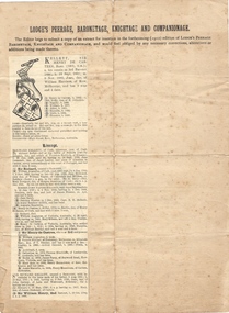
Document, Lodge's Peerage, Baronetage, Knightage and Companionage - KELLETT, Sir Henry de Castres Bart
... Street, East Kew. In 1884, Henry Kellett was elected to the Kew Borough Council and served for 40 years; a remarkable example of public service. He was elected Mayor for a single term in 1888-9. Sir Henry de Castres Kellett died in St George’s Hospital in 1924 following a tragic car accident in Cotham Road, Kew while on Council business. The vehicle, in which he was travelling with fellow councillors and the Town Clerk, collided with a tram. Sir Henry Kellett is commemorated in the naming of Kellett Reserve and Kellett Grove. mayors of kew (vic ...Sir Henry de Castres Kellett (1851-1924) the son of a hereditary baronet, was born at Mt Gambier, South Australia in 1851. His English title had been created in Ireland in 1801, but the family was originally Norman with the later branches living in England and Ireland. Sir Henry Kellett assumed the title in 1906. Henry Kellett was a prominent Kew retailer, continuing his father’s newspaper and stationery business in Bulleen Road (now High Street). At various stages, he also acted as an insurance, postal and real estate agent. He lived in Walpole Street and later at Lota Begg (now demolished) in Westbrook Street, East Kew. In 1884, Henry Kellett was elected to the Kew Borough Council and served for 40 years; a remarkable example of public service. He was elected Mayor for a single term in 1888-9. Sir Henry de Castres Kellett died in St George’s Hospital in 1924 following a tragic car accident in Cotham Road, Kew while on Council business. The vehicle, in which he was travelling with fellow councillors and the Town Clerk, collided with a tram. Sir Henry Kellett is commemorated in the naming of Kellett Reserve and Kellett Grove.Printed extract from Lodge's Peerage, Baronetage, Knightage and Companionage listing KELLETT, Sir Henry de Castres Bart.mayors of kew (vic), sir henry de castres kellett -
 Kew Historical Society Inc
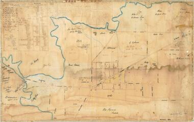
Map - Back to Kew 1875, Jesse Dannock, c.1931
... The most important and earliest original map of Kew in the collection, showing places of interest in early Kew. maps - kew (vic) mrs dannock's map cartography Hand-coloured map on heavy paper, depicting from Kew in 1875 from memory by Jesse Dannock. The map includes the names of local institutions and old residents. These, and many of the street ...The Kew Historical Society has an extensive collection of maps and plans; most relating to the former City of Kew (1860-1994). Within this collection, this hand-drawn map is unique.The most important and earliest original map of Kew in the collection, showing places of interest in early Kew.Hand-coloured map on heavy paper, depicting from Kew in 1875 from memory by Jesse Dannock. The map includes the names of local institutions and old residents. These, and many of the street names are very faded and have been overwritten with biro at a later date.maps - kew (vic), mrs dannock's map, cartography -
 Kew Historical Society Inc
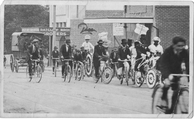
Photograph - Dark Town Wedding, 1922
... naming of the card has been included on Victorian Collections as representing the values of the period. The subject matter and original description is interesting as a reflection of social values by white Australians in the 1920s. fund-raising - kew (vic) parades - kew (vic) Dark Town Wedding 1922 Bride Bert Williams, Groom Mrs Stromach, Father Jack Allen, Best man ***, Pastor Snowy Raymond, Man on Penny Farthing Don Allen, won the Sun Office prize for the best decorated bike. Also in picture Ray Allen, Lawrie Allen. Don riding in procession. Ava Allen almost *** Picture taken in High Street ...A photograph of a fund-raising procession from 1922. The now politically incorrect use of black face by the participants and the naming of the card has been included on Victorian Collections as representing the values of the period.The subject matter and original description is interesting as a reflection of social values by white Australians in the 1920s.Photograph of a fund-raising bicycle ride in High Street, Kew in 1922. Donated by Alva Allen in 1987.Dark Town Wedding 1922 Bride Bert Williams, Groom Mrs Stromach, Father Jack Allen, Best man ***, Pastor Snowy Raymond, Man on Penny Farthing Don Allen, won the Sun Office prize for the best decorated bike. Also in picture Ray Allen, Lawrie Allen. Don riding in procession. Ava Allen almost *** Picture taken in High Street Kew in 1922 *** riding in processionfund-raising - kew (vic), parades - kew (vic) -
 Kew Historical Society Inc
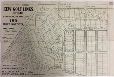
Plan - Subdivision Plan, Kew Golf Links Estate, 1936, 1936
... street names are somewhat different today as those on the map are named after the proposed Kodak Factory to be built on the site. The subdivision of the Kew Golf Links Estate was a major subdivision of farmland in Kew. The site was at one stage designated for industrial development and the building of a new Kodak factory. The decision by Council to oppose the redevelopment makes the beginning of the period when all industrial development was banned in Kew. subdivision plans - kew (vic ...The Kew Golf Links Estate was a major subdivision in North Kew. It derived its title due to the land being previously occupied by the Kew Golf Club, which transferred its course to a number of locations before occupying its current site. The Plan advertises 180 choice home sites. The street names are somewhat different today as those on the map are named after the proposed Kodak Factory to be built on the site. The subdivision of the Kew Golf Links Estate was a major subdivision of farmland in Kew. The site was at one stage designated for industrial development and the building of a new Kodak factory. The decision by Council to oppose the redevelopment makes the beginning of the period when all industrial development was banned in Kew.Monochrome printed, folded subdivision plan for the Kew Golf Links Estate, to be auctioned on 7 November 1936. Streets named include: Carnegie Avenue, Willsmere Road, Kilby Boulevarde, Kodak Avenue, Coleman Avenue, Beresford Avenue, McConchie Avenue, Cole Avenue, White Avenue, Baker Avenue, Spruzen Avenue, Tanner Avenue, Ratten Avenue, Mathers Avenue, Railway Avenue, Sutherland Avenue, and Belford Road. The position of the Yarra River and a large Drainage Reserve are marked on the plan. Lots for sale are numbered. Existing buildings are designated with a square.subdivision plans - kew (vic), kodak factory - kew (vic) -
 Kew Historical Society Inc
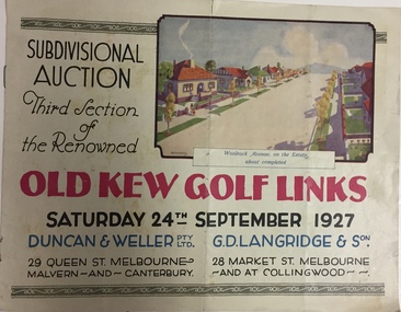
Booklet, Duncan & Weller Pty Ltd, Old Kew Golf Links Estate, 1927, 1927
... The decision by Council to oppose the redevelopment makes the beginning of the period when all industrial development was banned in Kew. subdivisions - kew (vic) kew golf links estate 6 page illustrated brochure advertising the third section of a major subdivision in Kew in 1927 including 75 charming home allotments and 7 valuable building sites. The brochure includes the subdivision plan. The front cover includes a colour illustration of the almost completed houses in Woolcock Avenue. Streets named ...The booklet advertises the third sale within the Old Golf Links Estate which was a major subdivision of farmland in North Kew in the 1920sThe subdivision of the Kew Golf Links Estate was a major subdivision of farmland in Kew. The site was at one stage designated for industrial development and the building of a new Kodak factory. The decision by Council to oppose the redevelopment makes the beginning of the period when all industrial development was banned in Kew.6 page illustrated brochure advertising the third section of a major subdivision in Kew in 1927 including 75 charming home allotments and 7 valuable building sites. The brochure includes the subdivision plan. The front cover includes a colour illustration of the almost completed houses in Woolcock Avenue. Streets named include: Kilby Road, Kodak Avenue, Baker Avenue, Mathers Avenue, Coleman Avenue, White Avenue and Belford Road. Lots for sale are numbered. Existing buildings are designated with a square.subdivisions - kew (vic), kew golf links estate -
 Kew Historical Society Inc
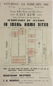
Plan - Subdivision Plan, Subdivision by Auction: 16 Ideal Home Sites, East Kew, 1940, 1940
... streets having a high degree of architectural uniformity. The subdivision in the second year of the war indicates that land sales for homes and speculation continued from the 1930s into the period of the Second World War. There is no indication on the plan that a war is occurring. subdivision plans - kew east (vic) A number of lots are coloured pink on the plan indicating those lots for sale and/or those already sold. Single page subdivision plan advertising the sale by Auction of 16 Ideal Home Sites, in East Kew, on 17 February 1940. Streets named ...An advertisement for the sale of a subdivision by Auction: of 16 Ideal Home Sites, East Kew, 1940. This significant sale of land between the Kew Golf Course and Willsmere Park led to the streets having a high degree of architectural uniformity.The subdivision in the second year of the war indicates that land sales for homes and speculation continued from the 1930s into the period of the Second World War. There is no indication on the plan that a war is occurring.Single page subdivision plan advertising the sale by Auction of 16 Ideal Home Sites, in East Kew, on 17 February 1940. Streets named in the plan include: Kilby Road, Belford Road, Elm Grove, Willow Grove. Willsmere Park is indicated but not named. The auction was conducted by Beauchamp Brothers. A number of lots are coloured pink on the plan indicating those lots for sale and/or those already sold.subdivision plans - kew east (vic) -
 Kew Historical Society Inc
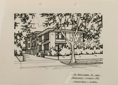
Drawing - Property Illustration, Margaret Picken, 1/178 Brougham Street, Kew, 1993
... The year in which the drawing was created is also a valuable record for house historians, as a number of the properties depicted have either been altered since that date or demolished. artist -- margaret picken 1950- architectural drawings -- houses -- kew (vic.) 1/178 brougham street -- kew (vic.) 1/178 BROUGHAM ST., KEW / MARGARET PICKEN '93 / WOODARDS ~ C'WELL Modern (1960s?) block of units, named ...After training as a Cartographic Draftsman within the mining industry, I worked as a property illustrator for real estate firms in the eastern suburbs of Melbourne for 23 years from 1983. I initially photographed houses with a Polaroid camera and made a 'thumbnail' sketch while there. The photos were used to scale off a sketch in pencil and then that sketch was overlaid with drafting film and the 'pen and ink' completed. The pens I used were the Rotring ‘Rapidigraph’ drafting pens. The ink was also made by Rotring (German).The film was ‘Rapidraw’, polyester drafting film, double matte. It takes a very fine line and doesn’t bleed. As well as house sketches, there were often floor plans and site plans ordered. Aerial sketches were ordered when the property needed an overall view. (Margaret Picken, 2020)This drawing is one of a series created by Margaret Picken for a range of real estate agents in Melbourne between c.1983 and c.2005. Each work is signed and dated by the artist.Gift of Margaret Picken, 2020Modern (1960s?) block of units, named 'Panoramic View'. The pen and ink drawing on drafting film of 1/178 Brougham Street was made by Margaret Picken in 1993.1/178 BROUGHAM ST., KEW / MARGARET PICKEN '93 / WOODARDS ~ C'WELLartist -- margaret picken 1950-, architectural drawings -- houses -- kew (vic.), 1/178 brougham street -- kew (vic.) -
 Kew Historical Society Inc
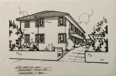
Drawing - Property Illustration, Margaret Picken, 6/29 Mary Street, Kew, 1989
... The year in which the drawing was created is also a valuable record for house historians, as a number of the properties depicted have either been altered since that date or demolished. artist -- margaret picken 1950- architectural drawings -- houses -- kew (vic.) 6/29 mary street - kew (vic). 6/29 MARY ST., KEW / MARGARET PICKEN '89 / WOODARDS ~ KEW Unit 6 in a two storey, variegated cream brick group of apartments. Built by the Kew Baptist Church in 1964 on the grounds of 'Rangeview' and using that name. ...After training as a Cartographic Draftsman within the mining industry, I worked as a property illustrator for real estate firms in the eastern suburbs of Melbourne for 23 years from 1983. I initially photographed houses with a Polaroid camera and made a 'thumbnail' sketch while there. The photos were used to scale off a sketch in pencil and then that sketch was overlaid with drafting film and the 'pen and ink' completed. The pens I used were the Rotring ‘Rapidigraph’ drafting pens. The ink was also made by Rotring (German).The film was ‘Rapidraw’, polyester drafting film, double matte. It takes a very fine line and doesn’t bleed. As well as house sketches, there were often floor plans and site plans ordered. Aerial sketches were ordered when the property needed an overall view. (Margaret Picken, 2020)This drawing is one of a series created by Margaret Picken for a number of real estate agents in Melbourne between 1983 and 2005. Each work is signed and dated by the artist.Gift of Margaret Picken, 2020Unit 6 in a two storey, variegated cream brick group of apartments. Built by the Kew Baptist Church in 1964 on the grounds of 'Rangeview' and using that name. Pen and ink architectural drawing on drafting film of 6/29 Mary Street, Kew by Margaret Picken. 6/29 MARY ST., KEW / MARGARET PICKEN '89 / WOODARDS ~ KEWartist -- margaret picken 1950-, architectural drawings -- houses -- kew (vic.), 6/29 mary street - kew (vic). -
 Kew Historical Society Inc
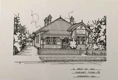
Drawing - Property Illustration, Margaret Picken, 16 Kent Street, Kew, 1993
... The year in which the drawing was created is also a valuable record for house historians, as a number of the properties depicted have either been altered since that date or demolished. artist -- margaret picken 1950- architectural drawings -- houses -- kew (vic.) 16 kent street -- kew (vic.) 16 KENT ST., KEW / MARGARET PICKEN '93 / WOODARDS ~ KEW Double-fronted weatherboard Edwardian residence; named 'Goodwood'. ...After training as a Cartographic Draftsman within the mining industry, I worked as a property illustrator for real estate firms in the eastern suburbs of Melbourne for 23 years from 1983. I initially photographed houses with a Polaroid camera and made a 'thumbnail' sketch while there. The photos were used to scale off a sketch in pencil and then that sketch was overlaid with drafting film and the 'pen and ink' completed. The pens I used were the Rotring ‘Rapidigraph’ drafting pens. The ink was also made by Rotring (German).The film was ‘Rapidraw’, polyester drafting film, double matte. It takes a very fine line and doesn’t bleed. As well as house sketches, there were often floor plans and site plans ordered. Aerial sketches were ordered when the property needed an overall view. (Margaret Picken, 2020)This drawing is one of a series created by Margaret Picken for a number of real estate agents in Melbourne between 1983 and 2005. Each work is signed and dated by the artist.Gift of Margaret Picken, 2020Double-fronted weatherboard Edwardian residence; named 'Goodwood'. Pen and ink architectural drawing on drafting film of 16 Kent Street, Kew by Margaret Picken. 16 KENT ST., KEW / MARGARET PICKEN '93 / WOODARDS ~ KEWartist -- margaret picken 1950-, architectural drawings -- houses -- kew (vic.), 16 kent street -- kew (vic.) -
 Kew Historical Society Inc
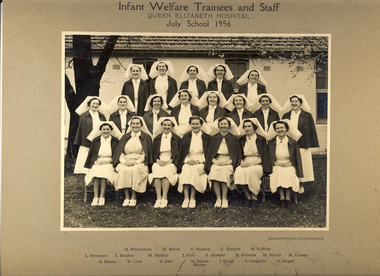
Photograph, Infant Welfare Trainees and Staff, Queen Elizabeth Hospital, 1956
... Kew, Victoria. It has a strong provenance through inscriptions linking it to the Denmark Street Maternal and Child Health Centre. denmark street maternal and child health centre baby health centres --- kew (vic) queen elizabeth hospital infant welfare Obverse: Infant Welfare Trainees and Staff, Queen Elizabeth Hospital, July School 1956 Reverse: "Presented to Kew Historical Soc by Dr Darbyshire following a 50 year birthday display at the Denmark Street Maternal and Child Health Centre [Kew] in May 1980. [Illegible]." Photograph, mounted on card of Infant Welfare Trainees and Staff, Queen Elizabeth Hospital, 1956. The photograph lists the names ...Carlton Refuge/Carlton Home was established in 1857 in Madeline Street, Carlton (relocating in 1890 to Keppel Street, Carlton). The Carlton Home provided maternity care for married and unmarried mothers, and residential care for infants and toddlers unable to be at home with their mother. It also operated a day-care centre for children. Most of the residents were mothers or children on private placements. The Children's Welfare Department used the Carlton Home as a maternity home for wards, a foster home for infant wards, and for children requiring placements under the infant life protection provisions of the Children's Welfare Act. By the late 1940s, the home was in a bad state of repair and it closed in 1949. In 1951, the facility reopened as the Queen Elizabeth Maternal and Child Health Centre that also operated as an Infant Welfare and Mothercraft Training School. The Centre provided after-care for nursing mothers and babies transferring from maternity hospitals, and specialised care for babies referred by private practitioners and the Social Welfare Department – babies who were premature, frail or had feeding or similar problems. (Source: DHHS)The photograph is a valuable primary resource relating to training for maternal and infant welfare centres in Kew, Victoria. It has a strong provenance through inscriptions linking it to the Denmark Street Maternal and Child Health Centre.Photograph, mounted on card of Infant Welfare Trainees and Staff, Queen Elizabeth Hospital, 1956. The photograph lists the names of the individuals below the photograph. They include: Back Row {L-R] M Whittenbury, M Bolton, E Haebich, G Barnard, M Griffiths / Middle Row [L-R] L Stevenson, T Boucher, M Madden, J Price, A Glowrey, R Helmore, M Murfet, M Lindsay / Front Row [L-R] R Buxton, W Crick, G Stott, M Buxton Matron, J Keogh, B Longmuir, E Borgelt.Obverse: Infant Welfare Trainees and Staff, Queen Elizabeth Hospital, July School 1956 Reverse: "Presented to Kew Historical Soc by Dr Darbyshire following a 50 year birthday display at the Denmark Street Maternal and Child Health Centre [Kew] in May 1980. [Illegible]."denmark street maternal and child health centre, baby health centres --- kew (vic), queen elizabeth hospital, infant welfare -
Kew Historical Society Inc
Archive (series) - Subject File, Adeney, William, 1971
... kew (vic.) clifton villa - cotham road - kew (vic.) Information file containing items of correspondence from 1971 relating to a query regarding the life of William Adeney, of Clifton Villa, Cotham Road. Researcher name - John Adeney. Response from Mrs E. West, KHS Secretary. The file contains snippets of original research on Adeney (Rate Books - William Adeney, Park Street ...Various PartiesReference, Research, InformationKHS OrderReference file containing items of correspondence from 1971 relating to a query regarding the life of William Adeney, of Clifton Villa, Cotham Road. Researcher name - John Adeney. Response from Mrs E. West, KHS Secretary. The file contains snippets of original research on Adeney (Rate Books - William Adeney, Park Street (later Adeney Avenue) 1878. The response refers to memories by Frances Dumaresq who knew the descendants.william adeney, adeney avenue - kew (vic.), clifton villa - cotham road - kew (vic.)william adeney, adeney avenue - kew (vic.), clifton villa - cotham road - kew (vic.) -
Kew Historical Society Inc
Archive (Sub-series) - Subject File, DALLEY, Marie (1880-1965) & CASCARRET, Clare, 1958
... kew (vic.) Archive file containing correspondence and newspaper articles/clippings. Correspondence is about naming a street after Marie Dalley. ...Various PartiesReference, Research, InformationSecondary Values (KHS Imposed Order)Subject file containing correspondence and newspaper articles/clippings. Correspondence is about naming a street after Marie Dalley. Marie Dalley lived at 31 Miller Grove. A newspaper article from 1981 also identifies 13 Bowen Street (built 1914) as the home of Ma Dalley’s daughter - Mrs Clare Cascarret (1959-76).marie (ma) dalley, mayors of kew, clare cascarret, miller grove - kew (vic.)marie (ma) dalley, mayors of kew, clare cascarret, miller grove - kew (vic.)
