Showing 1403 items matching "survey map"
-
 Bendigo Military Museum
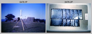
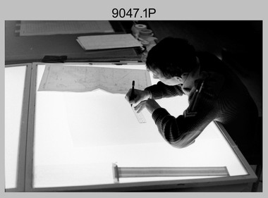
Photograph - Royal Australian Survey Corps - Map Production Processes, c1990
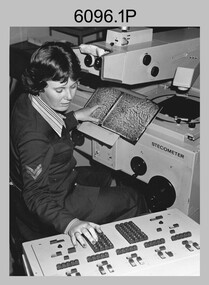
... Royal Australian Survey Corps - Map Production Processes...Royal Australian Survey Corps - Map Production Processes...Survey...Army Map Depot...This is a collection of 20 photographs of Royal Australian Survey Corps phases of map production at the School of Military Survey, Bonegilla, the Army Survey Regiment, Bendigo, and the Army Map Depot, Bandiana circa 1990. ...This is a collection of 20 photographs of map production processes taken at the School of Military Survey, Bonegilla, the Army Survey Regiment, Bendigo, and the Army Map Depot, Bandiana circa 1990. ... Corps - Map Production Processes Photograph Royal Australian Survey Corps - Map Production Processes Army Survey Regiment, Bendigo ...This is a collection of 20 photographs of Royal Australian Survey Corps phases of map production at the School of Military Survey, Bonegilla, the Army Survey Regiment, Bendigo, and the Army Map Depot, Bandiana circa 1990. Colour photos are on 35mm slide film and were scanned at 96 dpi. They are part of the Army Survey Regiment’s Collection. Photo .1P was probably taken on a survey station overlooking Lake Hume near Albury-Wodonga. The field party occupying the survey station was likely from a Map Control Survey course conducted by the School of Military Survey, Bonegilla. This survey station was part of a geodetic network used in field survey training and RASvy’s Lake Hume Test Range. Photos .3P to .16P were taken at the Army Survey Regiment, Bendigo and photos .17P & .18P were taken at the Army Map Depot, Bandiana. Photo .19P depicts a map of RASvy’s ARA units before the disbandment of 5th Field Survey Squadron, Perth and 2nd Field Survey Squadron, Sydney in 1990. This is a collection of 20 photographs of map production processes taken at the School of Military Survey, Bonegilla, the Army Survey Regiment, Bendigo, and the Army Map Depot, Bandiana circa 1990. Colour photos are on 35mm slide film and were scanned at 96 dpi. They are part of the Army Survey Regiment’s Collection. Photo .2P is printed on photographic and scanned at 300 dpi. .1) – Photo, colour, c1980s. Geodetic Surveying: AN/PRR-14 Geoceiver antenna on hill surrounding Lake Hume. Series 3 Land Rover, field party tent and survey station beacon in background. .2) – Photo, black & white, c1980s. Geodetic Surveying: AN/PRR-14 Geoceiver antennas set up at the School of Military Survey, Bonegilla, Victoria. .3) – Photo, colour, c1990. Aerotriangulation: Wild PUG4 point transfer device, SSGT Bruce Hammond. .4) – Photo, colour, c1990. Aerotriangulation: Zeiss (Jena) Stecometer, SSGT Bruce Hammond. .5) – Photo, colour, c1990. Aerotriangulation: computer tape maintenance, SSGT Noel McNamara. .6) – Photo, colour, c1990. AUTOMAP 2: computer tape maintenance, SPR Nadine (Paul) Read. .7) - Photo, colour, c1990s. AUTOMAP 2: Optronics 4040 scanning/film output in Lithographic Squadron, SGT Sherri (Dally) Burke. .8) - Photo, colour, c1990s. AUTOMAP 2: Benson verification plotter output, SPR Nadine (Paul) Read. .9) – Photo, colour, c1990. Aerotriangulation: data management, SGT Neil ‘Ned’ Kelly. .10) & .11) - Photo, colour, c1990s. AUTOMAP 2: Wild B8 Aviograph stereoplotter Feature Extraction, unidentified technician. .12) - Photo, colour, c1990s. AUTOMAP 2: Graphic Edit Workstation, SPR Nadine (Paul) Read. .13) - Photo, colour, c1990s. AUTOMAP 2: Graphic Edit Workstation, SPR Dawn Hoadley. .14) & .15) - Photo, colour, c1990s. AUTOMAP 2: Graphic Edit Workstation, unidentified technician. .16) – Photo, colour, c1990s. Heidelberg Speedmaster 102 computer-controlled five colour lithographic offset printing press. .17) & .18) – Photo, colour, c1990s. Army Map Depot, unidentified storeman, Bandiana. .19) – Photo, colour, c1990. RASvy ARA Unit Locations before disbandment of field units in Perth and Sydney. .20) – Photo, colour, c1990. Set of overlapping aerial photography..1P, .3P to .20P - Some equipment is identified on the frame of the 35mm slides.royal australian survey corps, rasvy, army survey regiment, army svy regt, fortuna, asr, school of military survey, army map depot -
 Bendigo Military Museum
Journal - Army Survey Regiment Map Store Distribution Register 1978-1986, 04.07.1978
... Army Survey Regiment Map Store Distribution Register 1978-1986...Army Survey Regiment Map Store Distribution Register 1978-1986...This is a record of the maps that were despatched from the Army Survey Regiment Map Store 1978 - 1986...Army Survey Regiment Map Store Distribution Register 1978-1986 Journal Army Survey Regiment Map Store Distribution Register 1978-1986 ...This is a record of the maps that were despatched from the Army Survey Regiment Map Store 1978 - 1986Leather Bound "Minute Book", lined paper, hand written records of ASR Map distribution. royal australian survey corps, rasvy, fortuna, army survey regiment, army svy regt, asr -
 Bendigo Military Museum
Photograph - Army Survey Regiment – Map Production, Fortuna, Bendigo, 1986
... Army Survey Regiment – Map Production, Fortuna, Bendigo...Army Survey Regiment – Map Production, Fortuna, Bendigo...These 17 photographs of the Army Survey Regiment’s map production and facilities were taken at Fortuna Villa, Bendigo, April 1986. ...This is a set of 17 photograph of Map Production and car park was taken at the Army Survey Regiment, Fortuna, Bendigo, in April 1986. ...Bendigo Military Museum 37 - 39 Pall Mall Bendigo goldfields These 17 photographs of the Army Survey Regiment’s map production and facilities were taken at Fortuna Villa, Bendigo, April 1986. ...These 17 photographs of the Army Survey Regiment’s map production and facilities were taken at Fortuna Villa, Bendigo, April 1986. Photos .1P to .3P were taken in Cartographic Squadron’s Correcting Section in the Attic. located on the top floor of Fortuna Photos .4P to .5P were taken in Cartographic Squadron’s Proving Section, located in the Ballroom also on the top floor facing the lake. The technicians were probably involved in a rapid response map production, as they all were wearing field uniforms. As ‘Regiment Overcrowding’ is annotated on the plastic sleeve holding the negatives, it seems the photos were taken when the unit was at its capacity to demonstrate the lack of suitable work areas. The Army Survey Regiment’s Duty Room, RAP and Carpark appearing in Photo .10P was probably taken from the top steps near the SGT’s accommodation block. Two of the photos in this set are also published in item 6096.5P.This is a set of 17 photograph of Map Production and car park was taken at the Army Survey Regiment, Fortuna, Bendigo, in April 1986. The black & white photographs are on 35mm negative film and are part of the Army Survey Regiment’s Collection. The photographs were scanned at 96 dpi. .1) - Photo, black & white, 1986. Correcting Section, Attic: L to R: CPL Andy Lucas, SPR Chris Gordon, unidentified, SPR Jan (Crighton) Minchin, CPL Robin Marshall, CPL Frank Downie, SPR Gayle Humphrey, unidentified (x2), Jason Wells at rear. .2) - Photo, black & white, 1986. Correcting Section, Attic: L to R: CPL Andy Lucas, SPR Chris Gordon, unidentified, SPR Jan (Crighton) Minchin, CPL Robin Marshall, CPL Frank Downie, SPR Gayle Humphrey, unidentified, Jason Wells, unidentified. .3) - Photo, black & white, 1986. Correcting Section, Attic: L to R: CPL Andy Lucas, CPL Robin Marshall, SPR Chris Gordon, unidentified, CPL Frank Downie, SPR Gayle Humphrey, unidentified, SPR Jan (Crighton) Minchin at rear., Jason Wells on phone. .4) & .5) - Photo, black & white, 1986. Proving Section, Ballroom: On left front to back: SGT Alan Staley, SGT Roger Rees, SGT Greg Anderson. On right front to back: SGT Denis McCarthy, SGT Tim Allanson, SSGT Adrian ‘Charlie’ Creedy. .6) - Photo, black & white, 1986. Records & Proofing buildings. .7) - Photo, black & white, 1986. Technical Services temporary buildings. .8) - Photo, black & white, 1986. Q-store and transport buildings. .9) - Photo, black & white, 1986. Technical Services temporary buildings in front of transport compound. .10) - Photo, black & white, 1986. Army Survey Regiment Duty Room, RAP and Carpark at Fortuna. .11) - Photo, black & white, 1986. Records & Proofing buildings. .12) - Photo, black & white, 1986. Other Ranks (OR’s) car park and barracks with kitchen in background. .13) - Photo, black & white, 1986. Other Ranks kitchen, parade ground and SGT’s/Officers barracks in background. .14) - Photo, black & white, 1986. Fortuna Villa taken from the steps near the SGT’s accommodation block. .15) - Photo, black & white, 1986. Fortuna Villa taken from the steps near the OR’s s accommodation block. .16) - Photo, black & white, 1986. Fortuna Villa taken from the roadway near the OR’s accommodation block. .17) - Photo, black & white, 1986. 20’ x 30’ Army tents set up on the basketball court..1P to .17P – ‘Regiment Overcrowding’ and the date are annotated on the plastic sleeve.royal australian survey corps, rasvy, army survey regiment, army svy regt, fortuna, asr -
 Whitehorse Historical Society Inc.
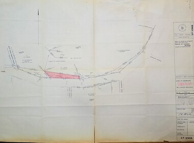
Map - WW1 map of France, WW1 map of France - regional. Field Survey Map of Enemy Rear Organisation, 08/10/1918
... WW1 map of France - regional. Field Survey Map of Enemy Rear Organisation...Field Survey Map of Enemy Rear Organisation...Field Survey Map of Enemy Rear Organisation Map WW1 map of France France 1918 WW1 ordnance survey ...Enemy Rear Organisation map Scale 1 : 40,000Field Survey Map of Enemy Rear Organisationnon-fictionEnemy Rear Organisation map Scale 1 : 40,000maps, world war 1914 - 1918 -
 Ringwood and District Historical Society
Map, Commonwealth Department of Defence, Military Survey map of Ringwood, 1916, Jun-16
... Military Survey map of Ringwood, 1916...Military Survey map of Ringwood +Additional Keywords: Hutchins,L...Received by postpak Military Survey map of Ringwood +Additional Keywords: Hutchins,L Military Survey map of Ringwood, 1916 Map Commonwealth Department of Defence ...Map prepared by Commonwealth Section Imperial General Staff given to Ringwood Historical SocietyMilitary Survey map of Ringwood +Additional Keywords: Hutchins,LL.Hutchins, 16 King's Rd. Marysville 3779. Received by postpak -
 Tatura Irrigation & Wartime Camps Museum
Photograph, Camp 3 Compound B Survey Map, 1942
... Camp 3 Compound B Survey Map......survey map...Camp 3 Compound B Survey Map Photograph Photograph ...Gives an interesting and definitive idea of circumstances and life in the POW camps of Australia. Detailed sketch of Compound B Camp 3 based on survey by Manfred MuellerDetailed sketch of Compound B Camp 13 based on survey by Manfred Mueller September 1942. On cream paper, laminated.camp 13, camp sketches, manfred mueller, survey map, compound b camp 3 -
 Port Melbourne Historical & Preservation Society
Map - Survey Map, Captain R Pasley R E, 24 Sep 1855
... Survey Map...Survey map to accompany Colonial Engineers Report, September 1855...Port Melbourne Historical & Preservation Society Port Melbourne Town Hall 333 Bay Street Port Melbourne melbourne melbourne Survey map to accompany Colonial Engineers Report, September 1855 Map Survey Map Captain R Pasley R E Surveyor General's Office J Jones Lith ...Survey map to accompany Colonial Engineers Report, September 1855melbourne -
 Bendigo Military Museum
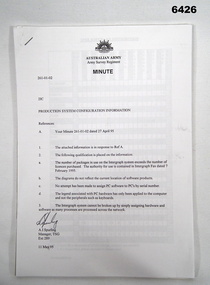
Administrative record - Army Survey Regiment Map Production System Configuration GESS/RSSS, 11 May 1995
... Army Survey Regiment Map Production System Configuration GESS/RSSS...Army Survey Regiment Map Production System Configuration GESS/RSSS...Royal Australian Survey Corps RASvy Fortuna Army Survey Regiment Army Svy Regt ASR Intergraph Corporation A4 Army Survey Regiment Minute - Author AJ Spurling Manager Tech Spt Gp 11 May 95 Army Survey Regiment Map Production System Configuration GESS/RSSS Administrative record Army Survey Regiment Map Production System Configuration GESS/RSSS AJ Spurling, Manager TSG ...This minute encloses a copy of the Software Licence Agreement with Intergraph Corporation Pty Ltd that applies to the software packages within the Automap Raster Sub System (RSSS) and the Graphic Edit Sub System (GESS) at the Army Survey Regiment.A4 Army Survey Regiment Minute - Author AJ Spurling Manager Tech Spt Gp 11 May 95royal australian survey corps, rasvy, fortuna, army survey regiment, army svy regt, asr, intergraph corporation -
 Bendigo Military Museum
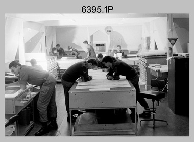
Photograph - Army Survey Regiment Map Production Equipment, c1980s, c1990s
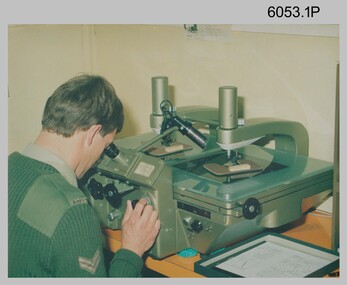
... Army Survey Regiment Map Production Equipment...Army Survey Regiment Map Production Equipment...This is a set of eight photographs of technicians operating map production equipment at the Army Survey Regiment, Bendigo. ...AUTOMAP 2 Graphic Edit Workstation, L to R: unidentified, SPR Peter Smyth, SPR Frank Savy, SPR Quentin Seecamp, CPL Steve McGuiness in Cartographic Squadron. Army Survey Regiment Map Production Equipment Photograph Army Survey Regiment Map Production Equipment Army Survey Regiment ...Photos .1P, .2P, and.4P were most likely taken in the 1980s and photos .3P, .5P to .8P in the c1990s at the Army Survey Regiment, Fortuna, Bendigo. Despite lacking annotation on exact dates, locations and personnel, they are positively identified. CPL Ian Nelson in photo .1P is operating a Wild Pug 4 point transfer device in Air Survey Squadron c1980s. Control points were transferred onto the mapping diapositives of aerial photography by drilling their locations into the photographic emulsion. SPR Viv (Hawkins) Doherty in photo .2P, SPR Jeanette Drury-Lane in photo .5P and SGT Sandy Craig are operating a Wild B8 Stereoplotter coupled to a digital workstation in Air Survey Squadron c1994. Topographic features were extracted with the B8 in 3D and feature coded with attributes, using keyboard, menu, keypad and voice inputs to the computer. The features were stored in the AUTOMAP 2 digital database for subsequent cartographic production and printing. CPL Mick Ellis in photo .3P is operating the Optronix 4040 Scanner/Film Writer in Lithographic Squadron c1990s. In scanning mode, compilation sheets were mounted on the drum and scanned. The resultant raster file was vectorized, feature coded with attributes and stored by cartographic technicians in the AUTOMAP 2 database. In film writing mode, digital cartographic files were output at very high resolution for each print colour on photosensitive film, for subsequent finalisation, platemaking and printing.This is a set of eight photographs of technicians operating map production equipment at the Army Survey Regiment, Bendigo. The photographs were printed on photographic paper and are part of the Army Survey Regiment’s Collection. The photographs were scanned at 300 dpi. Photo negatives were scanned at 2400 dpi. .1) - Photo, colour, c1980s. CPL Ian Nelson operating a Wild Pug 4 point transfer device in Air Survey Squadron. .2) - Photo, colour, c1980s. Wild B8 Aviograph stereoplotter feature extraction, SPR Viv (Hawkins) Doherty in Air Survey Squadron. .3) - Photo, colour, c1990s. CPL Mick Ellis operating the Optronics 4040 Scanner in Lithographic Squadron. .4) - Photo, colour, c1984. AUTOMAP 2 Graphic Edit Workstation, SPR Craig Kellet in Cartographic Squadron. .5) - Photo, colour, c1994. Wild B8 Aviograph stereoplotter feature extraction, SPR Jeanette Drury-Lane in Air Survey Squadron. .6) - Photo, colour, c1994. AUTOMAP 2 Graphic Edit Workstation, L to R: unidentified, SPR Rachel (Stanford) Scott, CPL Chris Wynn in Cartographic Squadron. .7) - Photo, colour, c1994. Wild B8 Aviograph stereoplotter AUTOMAP 2 Graphic Edit Workstation, L to R: unidentified (x2), SGT Sandy Craig in Air Survey Squadron. .8) - Photo, colour, c1994. AUTOMAP 2 Graphic Edit Workstation, L to R: unidentified, SPR Peter Smyth, SPR Frank Savy, SPR Quentin Seecamp, CPL Steve McGuiness in Cartographic Squadron. .1P – no annotations .2P – annotated “Stereoplotter Workstation. The operator has the use of keyboard, menu, keypad and voice for input to the computer. Feedback is given through voice and screen messages.” .3 to .8P – no annotationsroyal australian survey corps, rasvy, army survey regiment, army svy regt, fortuna, air survey, litho, aerotrig, automap 2 -
 Bendigo Military Museum
Photograph - Army Survey Regiment – Map Production, Fortuna, Bendigo, Army Survey Regiment – Map Production, Fortuna, Bendigo, c1990
... Army Survey Regiment – Map Production, Fortuna, Bendigo...Army Survey Regiment – Map Production, Fortuna, Bendigo....This is a set of five photograph of technicians performing map production tasks at the Army Survey Regiment, Fortuna, Bendigo, circa 1990. ...This is a set of five photograph of Map Production performed at the Army Survey Regiment, Fortuna, Bendigo, c1990. ...Army Survey Regiment – Map Production, Fortuna, Bendigo. ...This is a set of five photograph of technicians performing map production tasks at the Army Survey Regiment, Fortuna, Bendigo, circa 1990. Photos .1P to .4P were taken either in Air Survey Squadron or Cartographic Squadron.This is a set of five photograph of Map Production performed at the Army Survey Regiment, Fortuna, Bendigo, c1990. The photographs are on 35mm negative film and scanned at 96 dpi. They are part of the Army Survey Regiment’s Collection. .1) to .3) - Photo, black & white, c1990, CPL Greg Honan transfers map annotations from a field check map sheet to a master compilation sheet using a Rotring Isograph ink pen. .4) - Photo, black & white, c1990, SPR Mick Arnott verifies features in 3D with a Casella stereoscope on an overlapped pair of aerial photographs. .5) - Photo, black & white, c1990, SGT Sherri (Dally) Burke working in the AUTOMAP 2 system. .1P to .5P – There are no annotationsroyal australian survey corps, rasvy, fortuna, army survey regiment, automap 2 -
 Bendigo Military Museum
Photograph - Army Survey Regiment – Map Production, Fortuna, Bendigo, c1980s
... Army Survey Regiment – Map Production, Fortuna, Bendigo....Army Survey Regiment – Map Production, Fortuna, Bendigo....These five photographs of map production and the car park area were taken at Fortuna, Bendigo, c1980s. The first three photographs were taken in Air Survey Squadron, where aerotriangulation and digital photogrammetric extraction of topographic features from aerial photography were undertaken. ...This is a set of five photograph of Map Production and car park, at the Army Survey Regiment, Fortuna, Bendigo, c1980s. ...Army Survey Regiment – Map Production, Fortuna, Bendigo. ...These five photographs of map production and the car park area were taken at Fortuna, Bendigo, c1980s. The first three photographs were taken in Air Survey Squadron, where aerotriangulation and digital photogrammetric extraction of topographic features from aerial photography were undertaken. Photo .4P was taken in Cartographic Squadron’s Correcting Section, located in the Attic. The technicians were probably involved in a rapid response map production, as they all were wearing field uniforms. The Army Survey Regiment’s Duty Room, RAP and Carpark appear in Photo .5P. It was probably taken from the top steps near the SGT’s accommodation block in 1986. Photos .4P and .5P are also published with item 6395.17P.This is a set of five photograph of Map Production and car park, at the Army Survey Regiment, Fortuna, Bendigo, c1980s. The photographs were printed on photographic paper and is part of the Army Survey Regiment’s Collection. Photograph .1P was scanned at 200 dpi. The others were scanned at 300 dpi. .1) - Photo, black & white, c1980s: CPL Marrianne (Van De Zee) De Groot measuring aerial photographs with a stecometer. .2) - Photo, colour, c1980s: Two unidentified technicians assessing a flight line diagram. .3) - Photo, black & white, c1980s: SPR Scheryl Delforce digitising map features on an AUTOMAP 1 Graticon table. .4) - Photo, black & white, 1986: L to R: CPL Andy Lucas, SPR Chris Gordon, unidentified, SPR Jan (Crighton) Minchin, SPR Robin Marshall, CPL Frank Downie, SPR Gayle Humphrey, unidentified technicians in the Attic, Fortuna. .5) - Photo, black & white, 1986: Army Survey Regiment Duty Room, RAP and Carpark at Fortuna. .1P - Annotated on back ‘Maryanne Degroot’ .2P, .4P to .5P – no annotation .3P - Annotated on back ‘Scheryl Delforce’royal australian survey corps, rasvy, army survey regiment, army svy regt, fortuna, asr, air survey, carto, aerotrig -
 Ringwood and District Historical Society
Map, Partial Extract of Department of Lands and Survey Map, County of Mornington - 1955
... Partial Extract of Department of Lands and Survey Map, County of Mornington - 1955...Two sections of original Crown Portions survey map of Ringwood and Mooroolbark separated along fold lines. ...Partial Extract of Department of Lands and Survey Map, County of Mornington - 1955 Map ...Two sections of original Crown Portions survey map of Ringwood and Mooroolbark separated along fold lines. -
Sunshine and District Historical Society Incorporated
Map - Geological survey map of Derrimut, Maribyrnong , Kororoit and Jorrk
... Geological survey map of Derrimut, Maribyrnong , Kororoit and Jorrk....Geological survey map of Derrimut, Maribyrnong , Kororoit and Jerk. ...Geological survey map of Derrimut, Maribyrnong , Kororoit and Jerk. ... -
 Emerald Museum & Nobelius Heritage Park
Map - Survey Map - Municipality Road Classification - Beaconsfield-Emerald Rd. (near Downey Rd.) 1972, Title Survey Division, Crown Description - part of Crown Allotments 39A and 39D, Parish of Gembrook, County of Mornington, c1972
... Survey Map - Municipality Road Classification - Beaconsfield-Emerald Rd. ...Image of Crown survey map - changes to allotments bordering Beaconsfield-Emerald Rd. near Downey Rd. in 1972...CLARKE - Principal Title Survey Officer 5.9.72/SP 13072 Image of Crown survey map - changes to allotments bordering Beaconsfield-Emerald Rd. near Downey Rd. in 1972 Title Survey Division, Crown Description - part of Crown Allotments 39A and 39D, Parish of Gembrook, County of Mornington Map Survey Map - Municipality Road Classification - Beaconsfield-Emerald Rd. ...Image of Crown survey map - changes to allotments bordering Beaconsfield-Emerald Rd. near Downey Rd. in 1972Title Survey Division/Crown Description/Part of Crown Allotments 39A and 39D, Parish of Gembrook,County of Mornington/Municipality Road Classification - Shire of Berwick, Beaconsfield - Emerald Rd, Upper Beaconsfield - Upper Pakenham Road/John L Dwyer of Fisher Cleeland Turner & Dwyer Pty. Ltd., 213 King Street, Melbourne - 14 April, 1972/S.R. CLARKE - Principal Title Survey Officer 5.9.72/SP 13072 -
Lakes Entrance Historical Society
Map - Lakes Entrance Survey Map 1892-1895, 1895
... Lakes Entrance Survey Map 1892-1895...Survey map showing Rigby Island, Bullock Island, Snake Island, South Channel, Mt Barkley Kalimna...Lakes Entrance Historical Society 4 Marine Parade Lakes Entrance gippsland Islands Waterways Townships Survey map showing Rigby Island, Bullock Island, Snake Island, South Channel, Mt Barkley Kalimna Map Lakes Entrance Survey Map 1892-1895 ...Survey map showing Rigby Island, Bullock Island, Snake Island, South Channel, Mt Barkley Kalimnaislands, waterways, townships -
 Peterborough History Group
Map - Government map, Government Printer, Port campbell, 1957
... ...aerial survey map...Aerial survey map showing roads, vegetation and other landscape features....Original 1957 State Aerial Survey Map of Port Campbell region, including Peterborough...Significant because it shows the detail of the region in 1957 peterborough aerial survey map maps Port Campell Original 1957 State Aerial Survey Map of Port Campbell region, including Peterborough Port campbell Map Government map Government Printer ...Aerial survey map showing roads, vegetation and other landscape features.Significant because it shows the detail of the region in 1957Original 1957 State Aerial Survey Map of Port Campbell region, including Peterboroughpeterborough, aerial survey map, maps, port campell -
 Flagstaff Hill Maritime Museum and Village
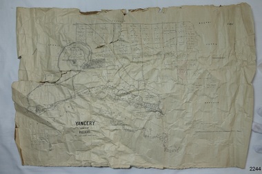
Map - Survey Map, F.F. McGovern, Yangery - County of Villiers, 1884
... Survey Map...map...yangery district...w.j. burson...borough of warrnambool...koroit...purnim...meerai...wangoom...proposal of tower hill for public recreation...special survey...The distances are accurately measured. This survey map was used for planning future land sales, recreation areas and roads. ...Survey map of Yangery, titled "Yangery - County of Villiers". ..."Scale: 8 chains to 1 inch" Survey map of Yangery, titled "Yangery - County of Villiers". ...A surveyor was employed to measure the land designated as Yangery, County of Villiers, in the Borough of Warrnambool. The area on the map is similar to the earlier Farnham Survey undertaken by William Rutledge in the 1850's. Warrnambool was a Borough between 1863-1883. Coutours, waterways, sea and other significant points are shown. The distances are accurately measured. This survey map was used for planning future land sales, recreation areas and roads. WILLIAM RUTLEDGE (1806-1876) William Rutledge surveyed the land known as Farnham in southwest Victoria in 1843. His tenants made him a profitable business from working the land there. In 1863 Rutledge moved from nearby Port Fairy to Farnham and became very successful in breeding sheep, which he imported from J.R. Kirkham of Lincolnshire, England. He also bred horses on his land. The survey map of Yangery is important for its connection with renowned surveyor William Rutledge. The map shows the growth of landholders in the district when compared to the original Rutledge survey of the 1850's.Survey map of Yangery, titled "Yangery - County of Villiers". Printed on white paper, mounted on brown paper. c. 1863-1876. Comments printed on the Map include; Special Survey by William Rutledge, Photo-lithographed at the Department of Lands and Survey, Melbourne by W.J. Burson, Price 1/- [one shilling]. Scale is in Chains. Map has boundaries of Koroit Borough, Meerai, Purnim, Wangoom, Borough of Warrnambool, Mentions the Proposal of Tower HIll for Public Recreation. The map names the owners of the land at that time. Hand written pencil marks and figures and "Sauls fence" drawn on map. Hand written pencil markes and figures and "Sauls fence" drawn onto map. "For Department Use only". "Scale: 8 chains to 1 inch" flagstaff hill, warrnambool, shipwrecked-coast, flagstaff-hill, flagstaff-hill-maritime-museum, maritime-museum, shipwreck-coast, flagstaff-hill-maritime-village, county of villiers map, yangery district, w.j. burson, borough of warrnambool, koroit, purnim, meerai, wangoom, proposal of tower hill for public recreation, special survey by william rutledge, william rutledge, farnham, lincolnshire sheep, clydesdale -
 Ringwood and District Historical Society
Map, Heathmont/Bayswater Area Survey Map - 1956
... Heathmont/Bayswater Area Survey Map - 1956....Cutaway section of black & white Dandenong Ranges Area survey map with countour lines centred over Bedford Road and Canterbury Road, Heathmont, and Bayswater Road and Wantirna-Sassafras Road (Mountrain Highway) Bayswater, Victoria. ...Heathmont/Bayswater Area Survey Map - 1956. Map ...Cutaway section of black & white Dandenong Ranges Area survey map with countour lines centred over Bedford Road and Canterbury Road, Heathmont, and Bayswater Road and Wantirna-Sassafras Road (Mountrain Highway) Bayswater, Victoria. Chivers property marked on Armstrong Road, Heathmont.Caption: "Compiled by Department of Lands and Survey July 1956, from aerial photographs and cadastral survey informaton. Controlled by triangulation and traverse. Elevations in feet. Datum. L.W.M. Williamstown. Transverse , Mercator Projection. Zone 7." -
Lakes Entrance Historical Society
Map - Survey Map Bullock Island, J D Sherwood, 28/3/1968
... Survey Map Bullock Island...Survey map shows Bullock Island PWD Depot, Elliot Engineering Co., Steel Boat Building Co of Australia, Lakes Entrance Fisherman's Co-operative Society Ltd., Lakes Entrance Processing Pty Ltd....Map Survey Map Bullock Island J D Sherwood ...Survey map shows Bullock Island PWD Depot, Elliot Engineering Co., Steel Boat Building Co of Australia, Lakes Entrance Fisherman's Co-operative Society Ltd., Lakes Entrance Processing Pty Ltd.J D Sherwood 28/3/68. District erSurveyer islands, businesses, surveying -
Ringwood and District Historical Society
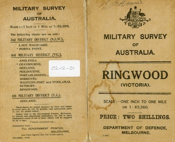
Map, Government Printer, Melbourne, Ringwood Zone Ordinance Survey Map, 1935
... Ringwood Zone Ordinance Survey Map...Ordinance survey map glued to cheesecloth, of Ringwood zone - Commonwealth topographical map dated 1.8.35, scale 1:63,360. ...+Additional Keywords: Reid, Don Ringwood Zone Ordinance Survey Map Map Government Printer, Melbourne ...Ordinance survey map glued to cheesecloth, of Ringwood zone - Commonwealth topographical map dated 1.8.35, scale 1:63,360. Information correct up to June 1922. "Ringwood 81" printed on the reverse side.; Envelope and note from donor of item, with return letter of appreciation from Ringwood & District Historical Society dated 20-May-2005. +Additional Keywords: Reid, Don -
 Bendigo Military Museum
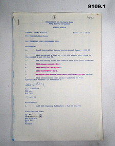
Administrative record (item) - Army Survey Regt. Minute. Map Printing Report 1990 - 1991, Army Svy Regt, 1990
... Army Survey Regt. Minute. Map Printing Report 1990 - 1991...Army Survey Regt. Minute. Map Printing Report 1990 - 1991...Map Printing Report 1990 - 1991 Administrative record Army Survey Regt. Minute. ...Maps published at ASR .1 Map Printing 1 Jul - 30 Sept 1990. .2 Map Printing 1 Oct - 31 Oct 1990. .3 Map Printing Nov 1990 - Jan 1991asr, fortuna -
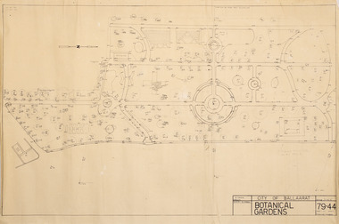
 Friends of Ballarat Botanical Gardens History Group
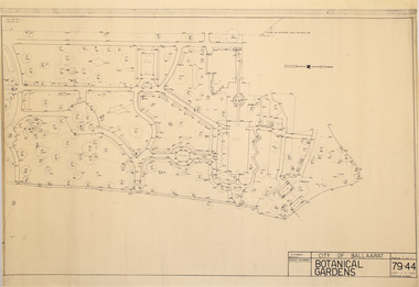
Plan - Survey Plan A, G. Creek, City of Ballarat Botanical Gardens
... Survey Map...Survey map on paper...Friends of Ballarat Botanical Gardens History Group George Longley Building Gillies Street North entrance Ballarat West 3350 Historic Survey Map City of Ballaarat Ballarat Botanical Gardens Survey map on paper City of Ballarat Botanical Gardens Plan Survey Plan A G. ...HistoricSurvey map on papersurvey map, city of ballaarat, ballarat botanical gardens -
 Friends of Ballarat Botanical Gardens History Group
Plan - Survey Plan A, G. Creek, City of Ballarat Botanical Gardens
... Survey Map...Survey map on paper...Friends of Ballarat Botanical Gardens History Group George Longley Building Gillies Street North entrance Ballarat West 3350 Historic Survey Map City of Ballaarat Ballarat Botanical Gardens Survey map on paper City of Ballarat Botanical Gardens Plan Survey Plan A G. ...HistoricSurvey map on papersurvey map, city of ballaarat, ballarat botanical gardens -
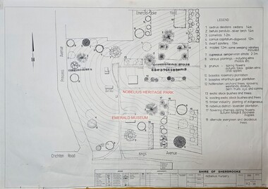 Emerald Museum & Nobelius Heritage Park
Map - Image of Nobelius Nursery - site of plants notated, Survey map of the Nobelius nursery, Unknown
... Survey map of the Nobelius nursery... may showing Nobelius Nursery in Nobelius heritage park Survey map of the Nobelius nursery Map Image of Nobelius Nursery - site of plants notated ...Plant map of the Nobelius Nursery, Nobelius heritage ParkImage of a survey may showing Nobelius Nursery in Nobelius heritage parkShire of Sherbrooke/Nobelius Nursery/R2-38/Legen (Plant type and location? -
 Emerald Museum & Nobelius Heritage Park
Map - Surveyors map of Wellington Rd. near Magpie Rd., Clematis, Part of Crown allotments 106E and 106G2, survey map of Wellington Rd., near Magpie Rd. 1972, c1972
... Part of Crown allotments 106E and 106G2, survey map of Wellington Rd., near Magpie Rd. 1972... outlining part of Wellington Rd., Near Magpie Rd., Clematis 1972 Part of Crown allotments 106E and 106G2, survey map of Wellington Rd., near Magpie Rd. 1972 Map Surveyors map of Wellington Rd. near Magpie Rd., Clematis ...Image of Surveyors map outlining part of Wellington Rd., Near Magpie Rd., Clematis 1972Title Survey Division/Crown Description/Part of Crown Allotments 106E and 106G2/Parish of Narree Worran, County of Mornington/Cardinia/Shire of Sherbrooke, Wellington Road/Rossley Paul Gardiner of Kirkpatrick & Webber, 289 Maroondah Hwy, Ringwood/Signed S.R. Clarke 21.6.72/B.A. Gibson C/T 8047/414 subtract 0.01 1/2 for Title -
 Emerald Museum & Nobelius Heritage Park
Map - Surveyors map of Wellington Rd. near Magpie Rd., and Paradise Rd., Clematis, Part of Crown allotments 106E and 106G2, survey map of Wellington Rd., near Magpie Rd. and Paradise Rd., Clematis 1972, c1972
... Part of Crown allotments 106E and 106G2, survey map of Wellington Rd., near Magpie Rd. and Paradise Rd., Clematis 1972... outlining part of Wellington Rd., Near Magpie Rd. and Paradise Rd., Clematis 1972 Part of Crown allotments 106E and 106G2, survey map of Wellington Rd., near Magpie Rd. and Paradise Rd., Clematis 1972 Map Surveyors map of Wellington Rd. near Magpie Rd., and Paradise Rd., Clematis ...Image of Surveyors map outlining part of Wellington Rd., Near Magpie Rd. and Paradise Rd., Clematis 1972Title Survey Division/Crown Description/Part of Crown Allotments 106F2 and 106G1/Parish of Narree Worran, County of Mornington/Cardinia/Shire of Sherbrooke, Wellington Road/Rossley Paul Gardiner of Kirkpatrick & Webber, 289 Maroondah Hwy, Ringwood/Signed S.R. Clarke 21.6.72 -
 Emerald Museum & Nobelius Heritage Park
Map - Surveyors map of Wellington Rd. near Magpie Rd., and Paradise Rd., Clematis, Part of Crown allotments 106F2 and 106G1, survey map of Wellington Rd., near Magpie Rd. and Paradise Rd., Clematis 1972, c1972
... Part of Crown allotments 106F2 and 106G1, survey map of Wellington Rd., near Magpie Rd. and Paradise Rd., Clematis 1972... outlining part of Wellington Rd., Near Magpie Rd. and Paradise Rd., Clematis 1972 Part of Crown allotments 106F2 and 106G1, survey map of Wellington Rd., near Magpie Rd. and Paradise Rd., Clematis 1972 Map Surveyors map of Wellington Rd. near Magpie Rd., and Paradise Rd., Clematis ...Image of Surveyors map outlining part of Wellington Rd., Near Magpie Rd. and Paradise Rd., Clematis 1972Title Survey Division/Crown Description/Part of Crown Allotments 106F2 and 106G1/Parish of Narree Worran, County of Mornington/Cardinia/Shire of Sherbrooke, Wellington Road/Rossley Paul Gardiner of Kirkpatrick & Webber, 289 Maroondah Hwy, Ringwood/Signed S.R. Clarke 21.6.72 -
Emerald Museum & Nobelius Heritage Park
Map - Municipality Road Classification - Wellington Rd. (part) - Near Kitty Street, Crown Survey map - Crown allotments 106F2 & 106 G1 - Wellington Rd. near Kitty Street, c1972
... Crown Survey map - Crown allotments 106F2 & 106 G1 - Wellington Rd. near Kitty Street...CLARKE, Principal Title Survey Officer & Proper Officer 21.6.72 Image of Title survey - Part of Crown Allotments 106F2 and 106G1 - Wellington Road, Shire of Sherbrooke Crown Survey map - Crown allotments 106F2 & 106 G1 - Wellington Rd. near Kitty Street Map Municipality Road Classification - Wellington Rd. ...Image of Title survey - Part of Crown Allotments 106F2 and 106G1 - Wellington Road, Shire of Sherbrooke SP12969/Title Survey Division/Crown Description/Part of Crown Alloments 106F2, 106F3 and 106G1, Parish of Narree Worran, County of Mornington/Municipality Road Classification/Shire of Sherbrooke, Wellington Road/(signed) Rossley Paul Gardner of Kirkpatrick & Webber, 280 Maroondah Highway, Ringwood, 29th March 1972/(Signed) S.R. CLARKE, Principal Title Survey Officer & Proper Officer 21.6.72 -
 Ringwood and District Historical Society
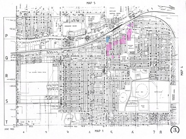
Document - A3 Photocopy, Department of Lands and Survey Map of Central and Southern Ringwood - June, 1983
... Department of Lands and Survey Map of Central and Southern Ringwood - June, 1983...Department of Lands and Survey Map of Central and Southern Ringwood - June, 1983 Document A3 Photocopy ...Numbered residential and commercial allotments mainly between Heatherdale Road and Great Ryrie Street and from Ringwood Square, Ringwood Market and Eastland shopping precinct in the north to Jubilee Park and Proclamation Park in the south. -
 Bendigo Military Museum
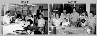
Photograph - Army Survey Regiment Open Day - Map Production, Fortuna, Bendigo, 1990
... Army Survey Regiment Open Day - Map Production, Fortuna, Bendigo...Army Survey Regiment Open Day - Map Production, Fortuna, Bendigo...The Royal Australian Survey Corps recognised that an Open Day was the best way for the local community in Bendigo to gain an insight into the unit’s important role as Defence’s map production agency, its technical equipment, and its economic importance to Bendigo. ...Army Survey Regiment Open Day - Map Production, Fortuna, Bendigo Photograph Army Survey Regiment Open Day - Map Production, Fortuna, Bendigo Army Survey Regiment ...These 35 photographs were taken at an Army Survey Regiment Open Day at Fortuna Villa, Bendigo on the 24th of February 1990. This occasion was one of several events held to commemorate the 75th anniversary of the formation of the Royal Australian Survey Corps. Although historical tours of Fortuna occurred on a regular basis, this was the first technical open day since 1972. The Royal Australian Survey Corps recognised that an Open Day was the best way for the local community in Bendigo to gain an insight into the unit’s important role as Defence’s map production agency, its technical equipment, and its economic importance to Bendigo. It also gave them an opportunity to tour through historic Fortuna Villa. This occasion is covered in more detail in page 143 of Valerie Lovejoy’s book 'Mapmakers of Fortuna – A history of the Army Survey Regiment’ ISBN: 0-646-42120-4. Refer to items 6434.27P and 6436.18P for more photos of the Open Day taken inside Fortuna, the garden areas and production areas of Lithographic Squadron. Photo prints of some of these photos were scanned and catalogued in items 6247.30P and 6291.6P.These 35 photographs were taken at an Army Survey Regiment Open Day held at Fortuna, Bendigo on the 24th of February 1990. The 35mm colour and black & white negatives photographs were scanned at 96 dpi and are part of the Army Survey Regiment’s Collection. .1) - Photo, black & white, 1990. CPL Neale ‘Tex’ Houston with visitors in Aerotriangulation Section. .2) - Photo, black & white, 1990. L to R: MAJ Peter Clark and WO2 Neil ‘Ned’ Kelly with visitors in Aerotriangulation Section. .3) - Photo, black & white, 1990. SGT Bruce Hammond with visitors in Aerotriangulation Section. .4) - Photo, colour, 1990. SGT Bruce Hammond with visitors in Aerotriangulation Section. .5) - Photo, colour, 1990. SGT Steve Gloster with visitors in Aerotriangulation Section. .6) - Photo, colour, 1990. L to R: CPL Noel Brinsmead and CPL Darren Wilkinson with visitors in Aerotriangulation Section. .7) - Photo, colour, 1990. L to R: CPL Noel Brinsmead with visitors in Aerotriangulation Section. .8) - Photo, colour, 1990. MAJ Peter Clark with visitors in Aerotriangulation Section. .9) - Photo, colour, 1990. CPL Mark Lander with visitors in Plotting Section. .10) - Photo, colour, 1990. SSGT Andy Boath with visitors in Plotting Section. .11) - Photo, colour, 1990. SPR Stuart Bowd with visitors in Plotting Section. .12) - Photo, colour, 1990. CAPT Roger Hancock with visitors in Plotting Section. .13) & .14) - Photo, colour, 1990. AUTOMAP 2 - CPL Peter Peterson with visitors. .15) - Photo, colour, 1990, AUTOMAP 2 - L to R: SSGT Graham Johnston, SPR Grant Davis with civilian visitors. .16) - Photo, colour, 1990, AUTOMAP 2 - L to R: CPL Steve McGuiness, SSGT Graham Johnston with civilian visitors. .17) - Photo, colour, 1990, AUTOMAP 2 - civilian visitors. .19) - Photo, colour, 1990, AUTOMAP 2 - L to R: unidentified, SPR Tony Jackson, CPL Mark Westbrook, SSGT Bob Bright, with civilian visitors. .20) - Photo, colour, 1990, AUTOMAP 2 - L to R: WO2 Adrian ‘Charlie’ Creedy, CPL Mark Westbrook, SPR Mick Duggan with civilian visitors. .21) - Photo, colour, 1990, AUTOMAP 2 - L to R: SPR Mick Duggan, CO LTCOM Rene van den Tol, SSGT Bob Bright, CPL Mark Westbrook with civilian visitors. .22) - Photo, colour, 1990, AUTOMAP 2 - L to R: SPR Damien Nolan, unidentified, SPR Peter Smyth with civilian visitors. .23) - Photo, black & white, 1990, AUTOMAP 2 - L to R: SPR Peter Smyth, CAPT Steve Hledik, SGT Martin Evans, MAJ Neil Taylor with civilian visitors. .24) - Photo, black & white, 1990, AUTOMAP 2 - L to R: SPR Mick Duggan, CPL Mark Westbrook with civilian visitors. .25) - Photo, black & white, 1990, AUTOMAP 2 – LCPL Sandy Winn with civilian visitor. .26) - Photo, black & white, 1990. Display of digital storage media. .27) & .28) - Photo, colour, 1990. Cartography - SPR Ian Baldwin with civilian visitors. .29) - Photo, black & white, 1990. Cartography - SPR Ian Baldwin with civilian visitors. .30) - Photo, black & white, 1990. Cartography - SGT Sherri (Dally) Burke with civilian visitors. .31) - Photo, colour, 1990. Cartography - L to R: SGT Sherri (Dally) Burke, SSGT Dennis Learmonth with civilian visitors. .32) - Photo, colour, 1990. Cartography – SGT Barry Hogan with civilian visitors. .33) & .34) - Photo, colour, 1990. Cartography – CPL Dan Cirsky with civilian visitors. .35) - Photo, colour, 1990. Cartography – L to R: SPR Jeanette (Lane) Dury-Lane, CPL Diane (Thomas) Soutar with civilian visitors..1P to .35P – no annotationsroyal australian survey corps, rasvy, army survey regiment, army svy regt, fortuna, asr, automap 2