Showing 170 items matching "the geographical society"
-
 Mission to Seafarers Victoria
booklet - Brochure, Cook's "Endeavour" Bark
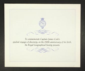
... A brochure produced in 1978 by the Royal Geographical Society, offering "by private invitation only" the opportunity for interested parties to purchase a print of the Bark 'Endeavour', in 24 karat gold and silver, of a very limited production run. ...Page 1 of the brochure consists of the Royal Geographical Society ensign at the top of the page and an introductory description of the commemoration, which is adorned above and below, with ink flourishes of curlicues and scrolls. ...Page 1: 'To commemorate Captain James Cook's epochal voyages of discovery, on the 250th anniversary of his birth, the Royal Geographical Society presents' ...The print was offered at $270 in 1978 - at not insignificant sum. 24 karat james cook endeavour royal geographical commemorative memorabilia souvenir Page 1: 'To commemorate Captain James Cook's epochal voyages of discovery, on the 250th anniversary of his birth, the Royal Geographical Society presents' Ornate paper and ink 3-page advertising brochure, in landscape orientation, from The Royal Geographical Society. ...A brochure produced in 1978 by the Royal Geographical Society, offering "by private invitation only" the opportunity for interested parties to purchase a print of the Bark 'Endeavour', in 24 karat gold and silver, of a very limited production run. The print was offered at $270 in 1978 - at not insignificant sum.Ornate paper and ink 3-page advertising brochure, in landscape orientation, from The Royal Geographical Society. The brochure is advertising the release of a commemorative framed silhouette print of the Bark 'Endeavour' in celebration of the 250th anniversary of the birth of Captain James Cook. Page 1 of the brochure consists of the Royal Geographical Society ensign at the top of the page and an introductory description of the commemoration, which is adorned above and below, with ink flourishes of curlicues and scrolls. Page 2 depicts an image of the framed silhouette print on offer. Page 3 contains 3 columns of text which briefly describe Captain Cook's travels, the work of the artist involved in producing the print and terms and conditions for ordering and purchase of the print. Page 1: 'To commemorate Captain James Cook's epochal voyages of discovery, on the 250th anniversary of his birth, the Royal Geographical Society presents' 24 karat, james cook, endeavour, royal geographical, commemorative, memorabilia, souvenir -
 Federation University Historical Collection
Book, Indian Geographical Society Department of Geography, The Indian Geographical Society Golden Jubilee Volume, 1976, 1976
... The Indian Geographical Society Golden Jubilee Volume, 1976...Indian Geographical Society Department of Geography...Smith Indian Geographical Society Department of Geography ...Robert H.T. Smith was Chancellor of University of Ballarat (later Federation University Australia).Orange hard covered book. robert h.t. smith, geography, regional planning, planning in india, madras, britain's green belts, metropolitan transport planning, traders in developing countries, remote sensing, medical geography -
 Victorian Aboriginal Corporation for Languages
Book, Catalogue of the manuscripts in the library of the Royal Geographical Society of Australasia (South Australian Branch) Inc, 1981
... Catalogue of the manuscripts in the library of the Royal Geographical Society of Australasia (South Australian Branch) Inc....Victorian Aboriginal Corporation for Languages 33 Saxon Street Brunswick melbourne Australian history sources Royal Geographical Society of Australasia manuscripts b&w illustrations, letters, documents Catalogue of the manuscripts in the library of the Royal Geographical Society of Australasia (South Australian Branch) Inc. ...b&w illustrations, letters, documentsaustralian history sources, royal geographical society of australasia, manuscripts -
Marysville & District Historical Society
Document (Item) - Research Document, Rene de Koning, Murchison Street Named After Roderick Impey Murchison (1792-1871), 13-08-2022
... ...the geographical society...His liberality and social position plus the pride he took in his science were of immense value in furthering the cause of learning in Britain. roderick impey murchison murchison street marysville victoria durham school royal military college great marlow peninsular war charlotte hugonin scotland muir of ord tarradale house ross and cromarty lower palaeozoic old red sandstone south wales welsh borderland the silurian system graywacke rocks adam sedgwick permian the geology of russia in europe and the ural mountains siluria cambrian system silurian system geological survey of great britain geological society the geographical society british association for the advancement of science wollaston medal geology geologist An account of the life of Roderick Impey Murchison whom Murchison Street in Marysville in Victoria is named for. ...An account of the life of Roderick Impey Murchison whom Murchison Street in Marysville in Victoria is named for.An account of the life of Roderick Impey Murchison whom Murchison Street in Marysville in Victoria is named for. Roderick Murchison was one of the most distinguished geologists of the 19th century. His liberality and social position plus the pride he took in his science were of immense value in furthering the cause of learning in Britain.roderick impey murchison, murchison street, marysville, victoria, durham school, royal military college great marlow, peninsular war, charlotte hugonin, scotland, muir of ord, tarradale house, ross and cromarty, lower palaeozoic, old red sandstone, south wales, welsh borderland, the silurian system, graywacke rocks, adam sedgwick, permian, the geology of russia in europe and the ural mountains, siluria, cambrian system, silurian system, geological survey of great britain, geological society, the geographical society, british association for the advancement of science, wollaston medal, geology, geologist -
 Emerald Museum & Nobelius Heritage Park
Relief prints, Thomas Baines et al, An Explorer's Camp, Circa 1875
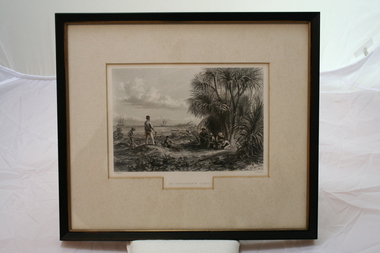
... Thomas Baines joined Augustus Gregory as official artist and storekeeper, in the expedition across northern Australia between 1855-1857 sponsored by the Royal Geographical Society to evaluate the northern area of Australia for suitability as a colonial settlement. ...Thomas Baines joined Augustus Gregory as official artist and storekeeper, in the expedition across northern Australia between 1855-1857 sponsored by the Royal Geographical Society to evaluate the northern area of Australia for suitability as a colonial settlement. ...Thomas Baines joined Augustus Gregory as official artist and storekeeper, in the expedition across northern Australia between 1855-1857 sponsored by the Royal Geographical Society to evaluate the northern area of Australia for suitability as a colonial settlement. ...From 'Australia' by Edwin Carton Booth. Thomas Baines joined Augustus Gregory as official artist and storekeeper, in the expedition across northern Australia between 1855-1857 sponsored by the Royal Geographical Society to evaluate the northern area of Australia for suitability as a colonial settlement. The Baines River was named after him.The item is socially and artistically significant as it is a very early image of Northern Australia.Framed black and white etching depicting a cap site located near the ocean.Artist T. Baines - J.J. Crew. From 'Australia' by Edwin Carton Booth. Thomas Baines joined Augustus Gregory as official artist and storekeeper, in the expedition across northern Australia between 1855-1857 sponsored by the Royal Geographical Society to evaluate the northern area of Australia for suitability as a colonial settlement. The Baines River was named after him.print, baines -
 Federation University Historical Collection
Certificate, Australian Geographical Society, Australian Geographical Society certificate made out to Keith Rash, 1957, 01/06/1957
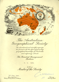
... Certificate of the Australian Geographical Society made out to Keith Rash. One printed page, map of Oceania including sailing ship, torch, map of Australia and surrounding islands. ...Australian Geographical Society certificate made out to Keith Rash, 1957 Certificate Certificate Australian Geographical Society ...Certificate of the Australian Geographical Society made out to Keith Rash. One printed page, map of Oceania including sailing ship, torch, map of Australia and surrounding islands. G. B. Walker (signature)rash, keith rash, australian geographical society, g.b. walker -
 Federation University Historical Collection
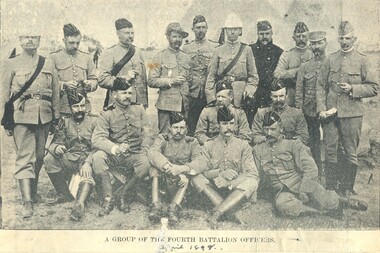
Image, Fourth Battalion, 1898, 1898
... Four magazine photographs. .1) Kitchen of the Fourth Battalion .2) Cadet Display at the Exhibition Ground, Jubilee Week, 1887 .3) 4th Battalion in Quarter Formation. .4) A group of Fourth Battalion officers, 1898 VersO - Certificate of the Royal Geographical Society of Australasia...Barker Library (top floor) Mount Helen goldfields The fourth Battalion appears to be made up of Castlemaine and Bendigo Residents. armed services fourth battalion cadets Voluntary regiment kitchen Exhibition grounds militia Four magazine photographs. .1) Kitchen of the Fourth Battalion .2) Cadet Display at the Exhibition Ground, Jubilee Week, 1887 .3) 4th Battalion in Quarter Formation. .4) A group of Fourth Battalion officers, 1898 VersO - Certificate of the Royal Geographical Society of Australasia Fourth Battalion, 1898 Image ...The fourth Battalion appears to be made up of Castlemaine and Bendigo Residents.Four magazine photographs. .1) Kitchen of the Fourth Battalion .2) Cadet Display at the Exhibition Ground, Jubilee Week, 1887 .3) 4th Battalion in Quarter Formation. .4) A group of Fourth Battalion officers, 1898 VersO - Certificate of the Royal Geographical Society of Australasiaarmed services, fourth battalion, cadets, voluntary regiment, kitchen, exhibition grounds, militia -
 Kiewa Valley Historical Society
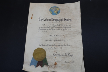
Certificate - Mrs C. Roper, The National Geographic Society
... The National Geographic Society issued certificates to their members. ...Roper, The National Geographic Society ...The National Geographic Society issued certificates to their members. This certificate is through the Board of Trustees from Columbia in the USA and signed by their secretaryClare Roper lived in the Kiewa ValleyA stiff paper with a coloured globe of the world top centre and coloured ribbon on the bottom left side. Dated 1957national geographic society, clare roper -
 Bendigo Historical Society Inc.
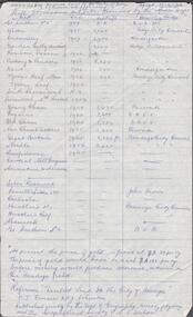
Document - ALBERT RICHARDSON COLLECTION: SHAFTS ALIENATED AND SITES RESERVED BY THE MINES DEPARTMENT
... Published jointly by the Dept of Geography, University of Sydney and The Geographical Society of NSW...., University of Sydney and The Geographical Society of NSW. Document ALBERT RICHARDSON COLLECTION: SHAFTS ALIENATED AND SITES RESERVED BY THE MINES DEPARTMENT ...Handwritten one page table of information. On top of page ' Ref. derelict land in the City of Bendigo copied 17.4.62. Shafts alienated and sites reserved by the Mines Dept' List of mines, dates, depth of shaft, receiving body. For example: Londonderry, 1957, 2900 feet, Kindergarten. Reference: 'Derelict Land in the City of Bendigo' P.J. Rimmer and R.J. Johnston. Published jointly by the Dept of Geography, University of Sydney and The Geographical Society of NSW.Albert Richardsonbendigo, mining, derelict land reused -
 Bendigo Historical Society Inc.
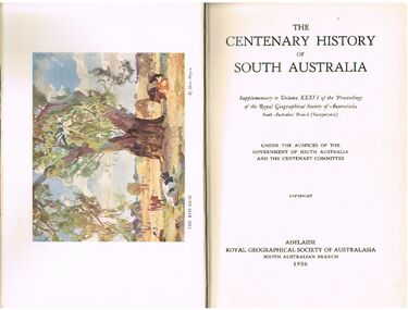
Book - ALEC H CHISHOLM COLLECTION: BOOK ''CENTENARY HISTORY OF SOUTH AUSTRALIA''
... Published in 1936 by The Royal Geographical Society of Australasia ( South Australian Branch). ...Published in 1936 by The Royal Geographical Society of Australasia ( South Australian Branch). ...Book. ALEC H CHISHOLM COLLECTION. 420 page history of South Australia (1836 - 1936). Illustrated with B & W photos, maps and a colour plate of a painting by Hans Heysen. Published in 1936 by The Royal Geographical Society of Australasia ( South Australian Branch). Printed by the Hassell Press, Adelaide. Chapters written by various contributors. Catalogue sticker ''2165 VAR'' on spine. A typed page stuck on the flyleaf indicates the book belonged to the Education Dept., Adelaide. Handwritten in ink on this typed insert ''Given to me by Adey's successor, Dr. C. Fenner. A H Chisholm''Variousbooks, collections, history, alec h chisholm collection, south australia, centenary, royal geographical society of australasia, history -
 Uniting Church Archives - Synod of Victoria
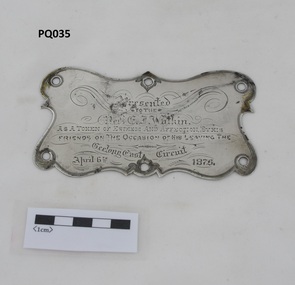
Plaque - Silver plaque, 1875
... He was a leading member of the Royal Geographical Society of Victoria. He had a winning personality and was held in high regard and affection by the communities in worked in. ...He was a leading member of the Royal Geographical Society of Victoria. He had a winning personality and was held in high regard and affection by the communities in worked in. ...Reverend Edwin Iredale Watkin, D.D. (1839-1916) was born in Sydney and spent his early life in New Zealand before coming to Australia . He began his Wesleyan ministry in 1859. He was a leading member of the Royal Geographical Society of Victoria. He had a winning personality and was held in high regard and affection by the communities in worked in. The plaque appears to be from the double-seated buggy the Rev E.I.Watkin was presented with together with an inscribed silver teapot, a set of gold studs and a gold pencil case on his leaving the Geelong East Methodist Circuit.Small silver plaque with an inscription and six holes around the edge."Presented TO THE REV. E.I. Watkin. AS A TOKEN OF ESTEEM AND AFFECTION BY HIS FRIENDS ON THE OCCASION OF HIS LEAVING THE Geelong East Circuit April 6th 1875"geelong east methodist circuit, yarra street wesleyan church, rev edwin iredale watkin (1839-1916) -
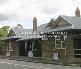
 Eltham District Historical Society Inc
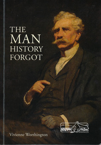
Book, The Man history forgot by Vivienne Worthington, 2018
... Panton CMG, Discovery of gold, 1854 Year of Exhibitions, Mining commission, Europe, Bohemia, art and marriage, artist in the western district, patron of Victorian Academy of Art, First Police Magistrate of city court, pioneer pastoralist, aboard the yacht "Cushie Doo", fellow of Royal Geographical Society, London, Inaugural President of Victorian Artists Society, Later Life of Joseph Panton....Panton CMG, Discovery of gold, 1854 Year of Exhibitions, Mining commission, Europe, Bohemia, art and marriage, artist in the western district, patron of Victorian Academy of Art, First Police Magistrate of city court, pioneer pastoralist, aboard the yacht "Cushie Doo", fellow of Royal Geographical Society, London, Inaugural President of Victorian Artists Society, Later Life of Joseph Panton. jospeh anderson panton biography frederick mccubbin cushie doo (ship) gold discovery police magistrate victorian artists society Softcover book The Man history forgot by Vivienne Worthington Book Publishing Productions ...Biography of Goldfields Commissioner Joseph Anderson Panton for whom Panton Hill was named for. The cover painting "J.A. Panton, Esq., PM" 1904 is by Frederick McCubbin. Sections in the book refer to : J. A. Panton CMG, Discovery of gold, 1854 Year of Exhibitions, Mining commission, Europe, Bohemia, art and marriage, artist in the western district, patron of Victorian Academy of Art, First Police Magistrate of city court, pioneer pastoralist, aboard the yacht "Cushie Doo", fellow of Royal Geographical Society, London, Inaugural President of Victorian Artists Society, Later Life of Joseph Panton.Softcover bookjospeh anderson panton, biography, frederick mccubbin, cushie doo (ship), gold discovery, police magistrate, victorian artists society -
 Bendigo Historical Society Inc.
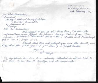
Document - LETTERS AND HISTORICAL RESEARCH INFORMTION: JOHANN MENGE, 1997
... Includes three letters to A Richardson from Val Menge (wife of possible descendant of Johann Menge) , dated December 19970, Feb 1971 and March 1971; Extract from ''South Australia and its Mines''(1846); Extract from ''Historical studies of Australia & New Zealand Vol 10''; Extract from the ''Australian Dictionary of Biography''; extract from George Stevenson's Journal in ''Royal Geographic Society of Australia - South Australian Branch, Vol 30, p. 62; Extract from ''The history of South Australia pp. 186-187; Extract from letter written by ''The South Australian Register'' (1852); Extract from '' Tasmanian Historical Research Association'' Papers and proceedings Vol 11, No. 2, pp 31 - 46; copy of book review (unknown paper) of ''Opal Men'', with sketch of Johann Menge, who first discovered opal in Australia. ...Includes three letters to A Richardson from Val Menge (wife of possible descendant of Johann Menge) , dated December 19970, Feb 1971 and March 1971; Extract from ''South Australia and its Mines''(1846); Extract from ''Historical studies of Australia & New Zealand Vol 10''; Extract from the ''Australian Dictionary of Biography''; extract from George Stevenson's Journal in ''Royal Geographic Society of Australia - South Australian Branch, Vol 30, p. 62; Extract from ''The history of South Australia pp. 186-187; Extract from letter written by ''The South Australian Register'' (1852); Extract from '' Tasmanian Historical Research Association'' Papers and proceedings Vol 11, No. 2, pp 31 - 46; copy of book review (unknown paper) of ''Opal Men'', with sketch of Johann Menge, who first discovered opal in Australia. ...Letters and historical research information re Johann Menge (1788-1852). Includes three letters to A Richardson from Val Menge (wife of possible descendant of Johann Menge) , dated December 19970, Feb 1971 and March 1971; Extract from ''South Australia and its Mines''(1846); Extract from ''Historical studies of Australia & New Zealand Vol 10''; Extract from the ''Australian Dictionary of Biography''; extract from George Stevenson's Journal in ''Royal Geographic Society of Australia - South Australian Branch, Vol 30, p. 62; Extract from ''The history of South Australia pp. 186-187; Extract from letter written by ''The South Australian Register'' (1852); Extract from '' Tasmanian Historical Research Association'' Papers and proceedings Vol 11, No. 2, pp 31 - 46; copy of book review (unknown paper) of ''Opal Men'', with sketch of Johann Menge, who first discovered opal in Australia. Menge was a mineralogist/geologist with a talent for languages - ''eccentric'' -died in poverty at Forest Creek, 1852.Val & Ted Mengeperson, individual, johann menge -
 Flagstaff Hill Maritime Museum and Village
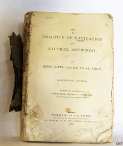
Book - Technical Reference, Henry Raper, Lieut. R.N, The Practice of Navigation and Nautical Astronomy, 1891
... (Friend of the Royal Geographical Society). The book is dedicated in honour of Rear-Admiral Sir Francis Beaufort K.C.B., Hydrographer to the Admiralty. ...(Friend of the Royal Geographical Society). The book is dedicated in honour of Rear-Admiral Sir Francis Beaufort K.C.B., Hydrographer to the Admiralty. ...This technical textbook is the nineteenth edition of the book by Henry Raper, Lieutenant in the Royal Navy with awards that include F.R.A.S. (Fellow of the Royal Astronomical Society) and F.R.G.S. (Friend of the Royal Geographical Society). The book is dedicated in honour of Rear-Admiral Sir Francis Beaufort K.C.B., Hydrographer to the Admiralty. He was awarded the title K.C.B. (King's Commander) as a Member of the Order of Bath, an order of British Chivalry, The book was first published in 1840 and soon became a resource for navigation students. It includes topics on nautical navigation, astronomy, navigation charts, calculations and mathematical tables, time, tides, ships, longitude, and position at sea. Thomas A. Hull, who revised and expanded this edition, was a Commander in the Royal Navy and had previously been Superintendent of Admiralty Charts used for navigation worldwide by seamen from many walks of life. The publisher, J D Potter of London, was at that time the sole agent for the Admiralty Charts produced by the Royal Navy. Printer Spottswoode and Co.,. was established by William Strachan in 1738. In 1819 his nephews A and R Spottswoode took over the business and bought premises in New-Street Square and Shoe Lane. In 1850 over 200 workers were employed by the firm. and five years later the business became Spottswoode & Co. Andrew Spottswoode invented the Spottswoode Press.This technical book was very popular as a textbook for students of maritime navigation, written and updated by members of the British Royal Navy and relied upon for accurate advice and information. The first edition was published in 1840, this edition was updated, expanded and published in 1891 when ports around the world were filling with travellers, merchants and business people. Title: The Practice of Navigation and Nautical Astronomy Author: Henry Raper, Lieut, R.N., F.R.A.S., F.R.G.S. Nineteenth Edition, revised and enlarged by Commander Thomas A. Hull, R.N., Late Superintendant of Admiralty Charts Dedication: To Rear-Admiral Sir Francis Beaufort K.C.B. Publisher: J D Potter, London, sole agent for the sale of Admiralty Charts Printer: Spottswoode and Co. New-Street Square, London Date: 1891 Small leather hardcover book with gold embossed text and lines on the spine. The Dedication in the book is as follows: - "To Rear-Admiral Sir Francis Beaufort K.C.B. Hydrographer to the Admiralty. Sir, The eminent station which you occupy in the naval scientific world renders it highly gratifying to me to dedicate the following Work to you as a testimony of my regard and esteem; while the general accordance of my views on the subject with those of your more experienced judgement, gives me the greater confidence in laying my labours before the Public. I have the honour to be, Sir, Your obedient servant, HENRY RAPER"flagstaff hill maritime museum, maritime museum, shipwreck coast, flagstaff hill, warrnambool, flagstaff hill maritime village, book, navigation, nautical astronomy, hydrography, nautical charts, nautical navigation, astronomical navigation, admiralty charts, henry raper, thomas a. hull, royal navy, j d potter, royal astronomical society, royal geographical society, calculations, mathematical tables, longitude, latitude, nautical time, location at sea, position at sea, maritime, practical navigation, spottswoode and co., sir francis beaufort, k.c.b., rear-admiral sir francis beaufort, hydrographer to the admiralty, scientific book, naval science -
 Eltham District Historical Society Inc
Photograph - Digital Photograph, Alan King, Panton Hill Hotel, 27 March 2008
... Panton was also an artist, becoming president of the Victorian Arts Society in 1888, and in 1913, president of the Royal Geographical Society. Despite Panton Hill’s prosperity, it still lacked many services as poor roads made access to Melbourne difficult. ...Panton was also an artist, becoming president of the Victorian Arts Society in 1888, and in 1913, president of the Royal Geographical Society. Despite Panton Hill’s prosperity, it still lacked many services as poor roads made access to Melbourne difficult. ...Today’s Panton Hill Hotel was built around 1920. Published: Nillumbik Now and Then / Marguerite Marshall 2008; photographs Alan King with Marguerite Marshall.; p61 Panton Hill was originally known as Kingstown, and consisted of only one hotel when the Orams Reef was discovered in 1859. Kingstown was a quartz mining centre and many old mine shafts remain in the area. Orams Reef was one of the first reefs with a rich find of gold in the area. The Hotel Francais, which had been operating in 1861, was well situated on the way to Queenstown (later St Andrews). So was Herr Hirt’s Hotel and store at Smiths Gully. The Kingstown hotel, known as the Frenchman’s and in 1864 as the Hotel de France, was run by a Monsieur Emile Hude and his wife Jeanne, and known for its good food. They hosted social events, business conventions and debates, attracting patrons from as far as Melbourne. The hotel’s name was changed to Panton Hill Hotel in 1905. In 1883 Charles Caudwell built another hotel nearby, possibly in Long Gully Road,3 which it is thought, was burnt down early last century. Today’s Panton Hill Hotel, built around 1920, is the only one of the cluster of buildings in the main road, not to date from around the turn of last century. It was severely damaged by fire in 2003, then underwent extensive alterations. It is the township’s only hotel and is an example of a modest hotel building exterior, constructed early last century. In its early days the hotel also housed the first post office, newsagency and store. Orams Reef yielded a total of £100,000, and fossikers also found alluvial gold in the creeks and gullies, but there is no record of the total value of their finds. Gold greatly increased the Panton Hill population, which peaked between 1865 and 1885. On holidays large sports meetings were held with wood chopping contests and foot races and the day would end with a ball. Miners came from various countries to seek their fortune, including many from China. The Chinese became unpopular however, and gradually left the district, although some stayed and grew and sold vegetables.5 Panton Hill was named after Joseph Panton, who in 1862 was appointed Police Magistrate for the Woods Point, Heidelberg and Yarra districts. Panton was an outstanding man, who in 1852, was Commissioner of Crown Lands and Assistant Commissioner of Goldfields at Bendigo. In 1874 he was promoted to Chief Magistrate for the Melbourne Police. Panton was also an artist, becoming president of the Victorian Arts Society in 1888, and in 1913, president of the Royal Geographical Society. Despite Panton Hill’s prosperity, it still lacked many services as poor roads made access to Melbourne difficult. A horse-drawn mail coach travelled to Melbourne until 1890, when the railway came to Heidelberg. The nearest doctor was at Yarra Glen or Heidelberg, and the Indian hawker Singh’s annual visit was very welcome. A miner’s shack opposite the school was used as a post office. Today’s general store and post office in the main road dates from early last century, and has changed considerably. While most people searched for gold, the more enterprising ones established farms to feed the diggers. Farmers grew wheat, barley and oats, and sent animal skins to the Eltham tannery, to make furs in Melbourne. As gold became scarce from around 1880, miners took up farming on 19 to 20 acre (8ha) allotments. The first settlers in Cherry Tree Road included Purcell, Smith, Owens, Hughes and Shillinglaw. By 1900 all the land had been taken up around Panton Hill and Hurstbridge. The orchards in Panton Hill and the wider district, particularly of apple and pear, were very successful, and made Panton Hill a cohesive and successful community. About 1914 the Moores built the first cool-store and refrigeration plant at their orchard in Cherry Tree Road. Many settlers planted vineyards and made high quality wine, but in 1922 the blight destroyed them.This collection of almost 130 photos about places and people within the Shire of Nillumbik, an urban and rural municipality in Melbourne's north, contributes to an understanding of the history of the Shire. Published in 2008 immediately prior to the Black Saturday bushfires of February 7, 2009, it documents sites that were impacted, and in some cases destroyed by the fires. It includes photographs taken especially for the publication, creating a unique time capsule representing the Shire in the early 21st century. It remains the most recent comprehenesive publication devoted to the Shire's history connecting local residents to the past. nillumbik now and then (marshall-king) collection, panton hill hotel -
 Warrnambool and District Historical Society Inc.
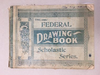
Booklet, The Federal Drawing Book Scholastic Series, C 1930
... Society Inc. 2 Gilles Street (south of Merri St) Warrnambool great-ocean-road This school book which was owned by George Mathieson contains maps and information on different countries around the world. It is handwritten and is probably of secondary school level. The maps appear to have been traced and hand-drawn and coloured. There is a loose newspaper map of the Dardenelles loose in the book. This book as an example of school work and geography ...This school book which was owned by George Mathieson contains maps and information on different countries around the world. It is handwritten and is probably of secondary school level. The maps appear to have been traced and hand-drawn and coloured. There is a loose newspaper map of the Dardenelles loose in the book. This book as an example of school work and geography in the early 20th century, has social and historical significance.Pale green light card cover with dark green pattern and text. Back cover is plain. It contains alternate pages of tracing paper in between normal pages. Bound with cotton? threadGeorge mathieson, written in ink on front cover.federal drawing book, george mathieson, school drawing book 1920's, warrnambool -
 Warrnambool and District Historical Society Inc.
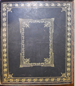
Book - Antiquarian book, Hon. Andrew Garran, Picturesque Atlas of Australasia Volume One, 1886
... Warrnambool and District Historical Society Inc. 2 Gilles Street (south of Merri St) Warrnambool great-ocean-road This book contains 19th century geographical and contemporary information on parts of Australasia and in particular, New South Wales and Victoria including the Western District. ...Contemporary and geographical record of Australasia in the 19th centuryThis is a leather covered book. The cover is decorated with gold panels of fruit and gold lettering on the spine and has a plastic cover to protect it. There is gilt edging on the 388 pages. It contains text, sketches, lithographs and some coloured maps and engravings on wood..non-fictionContemporary and geographical record of Australasia in the 19th centurywarrnambool history, western district history, australian history, australasian history, picturesque atlas of australasia, picturesque atlas of australasia volume 1 -
 Warrnambool and District Historical Society Inc.
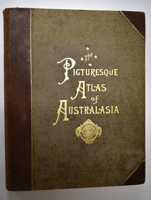
Book - Antiquarian Book, Hon Andrew Garran, Picturesque Atlas of Australasia Volume Two, 1886
... Warrnambool and District Historical Society Inc. 2 Gilles Street (south of Merri St) Warrnambool great-ocean-road This is a contemporary and geographical record of Australasia in the 19th century featuring the areas of Queensland, Tasmania, South Australia, Western Australia and New Zealand. ...A contemporary and geographical record of Australasia in the 19th centuryThis is a leather covered book of 801 pages. The cover is decorated with gold panels of fruit and has gold lettering on the spine. The pages have gilt edges. It contains text, sketches, lithographs, maps and five loose maps. non-fictionA contemporary and geographical record of Australasia in the 19th centuryaustralasian history, antiquarian books, picturesque atlas of australasia, warrnambool, picturesque atlas of australasia volume 2 -
 Warrnambool and District Historical Society Inc.
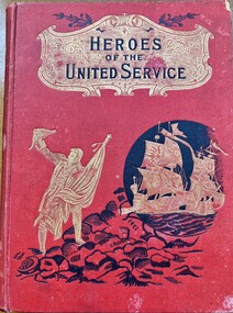
Literary work - Antiquarian Book, Heroes of The United Service, 1901
... Society Inc. 2 Gilles Street (south of Merri St) Warrnambool great-ocean-road This book Heroes of the United Service was produced in 1901 and relates the story of noted figures in the British Army and Navy . It was possibly chosen as a School prize as the deeds of many of these people was considered inspirational. It was awarded in May 1901 to a member of the Jackman family who were early settlers who farmed in the Mt Arapiles district. This book awarded to Arthur Jackman in 1901 for 4th form subjects of history, geography ...This book contains a number of stories which relate to heroes of the British Army and Navy . After a brief synopsis of the history of British military, it then commences from the conquest of Canada in 1759 and relates the stories of renown personnel through to the beginning of the 20th century.This book has a red cloth over card cover with black text mounted in a gold shield at the top of the cover with a gold figure of a sailor who is standing on black rocks. There is a gold image of two galleons inside a black circle. The spine has the title in black on a gold shield , similar to the front cover . The back cover is plain. It has 248 pages relating to the Armed Forces and 256 pages relating to naval stories.There are a number of colour plates and black and white drawings many depicting military scenes. Inside front and back covers are faced with brown and mustard coloured pages. There is a name plate inside the front cover. non-fictionThis book contains a number of stories which relate to heroes of the British Army and Navy . After a brief synopsis of the history of British military, it then commences from the conquest of Canada in 1759 and relates the stories of renown personnel through to the beginning of the 20th century.heroes of the united service, arthur jackman, jackman family, clear lake cemetery, jesuits st patricks college melbourne, jesuits st francis xavier melbourne, rector patrick keating -
 Warrnambool and District Historical Society Inc.
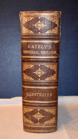
Book - educational encyclopaedia, Charles Beale & M. Gately, Gately's Universal Educator, 1886
... Warrnambool and District Historical Society Inc. 2 Gilles Street (south of Merri St) Warrnambool great-ocean-road This book is an encyclopaedia containing three volumes within the one book and has information on such topics as natural history, geology, astronomy, geography, legal matters, history, agriculture, mathematics, music and poetry. ...An encyclopaedia and business guide (late 19th century)This book has a brown leather cover which is heavily embossed with brown and gold patterns and gold lettering, The spine is torn at the top and the cover is worn at the edges.The pages are gilt-edged and contain printed text and black and white sketches, illustrations, maps and diagrams. non-fictionAn encyclopaedia and business guide (late 19th century)19th century australia, 19th century encyclopaedia, 19th century business guide -
 Warrnambool and District Historical Society Inc.
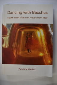
Book, Pam Marriott (publisher), Dancing With Bacchus, 2021
... Warrnambool and District Historical Society Inc. 2 Gilles Street (south of Merri St) Warrnambool great-ocean-road This book, written by Pamela Marriott, contains historical information on hotels in South West Victoria from 1839. It includes information on some hotel licensees, newspaper reports and stories and some geographical ...This book contains information on South West Victorian hotels from 1839This is a soft cover book of 348 pages. The cover has a white background with gold-coloured print, a red and orange image of dancers on the front cover and a photograph of liquor bottles and grapes on the back cover. The book contains a foreword, an index, printed text and black and white photographs.non-fictionThis book contains information on South West Victorian hotels from 1839 hotels in south west victoria, warrnambool history -
 Warrnambool and District Historical Society Inc.
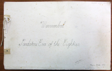
Magazine - Project, Warrnambool: sandstone era of the eighties, 1973
... Warrnambool and District Historical Society Inc. 2 Gilles Street (south of Merri St) Warrnambool great-ocean-road Geographically situated on the coast Warrnambool has large tracts of sedimentary rock, some of which is sandstone. ...Geographically situated on the coast Warrnambool has large tracts of sedimentary rock, some of which is sandstone. It therefore was a readily available material and as a relatively soft stone it was easily quarried and cut. By the 1880’s Warrnambool had been established for around forty years and was proving to be a settlement of some wealth. Hence the trend to build bigger and grander homes. There are numerous other commercial buildings which are built in sandstone and many of the original quarries are still visible around the Warrnambool area. Most of the properties are situated in the central part of Warrnambool. This collection of photographs is a good cross-section of some of the significant homes and buildings of Warrnambool. It also shows how they look 100 years after being built.A collection of 18 black and white photographs of sandstone houses, mounted on card and tied loosely with string. The addresses of each house are hand-written in black pen beside each photo. Title is written in black pen on cover page.Graeme Blake 1973 in bottom RH corner, Via * Fraser & Chris How in blue pencil.warrnambool, sandstone, sandstone houses, 1880 warrnambool -
 Kiewa Valley Historical Society
Papers - The Tobacco Industry
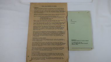
... Society Mount Beauty Information Centre 31 Bogong High Plains Rd Mt Beauty high-country Tobacco in the Kiewa Valley. Tobacco was grown in Victoria for many years but the main areas (from the 1960s) included the Upper Kiewa River Valley where areas were suited. A Tobacco Research Station was established in Myrtleford, the geographical ...Tobacco in the Kiewa Valley. Tobacco was grown in Victoria for many years but the main areas (from the 1960s) included the Upper Kiewa River Valley where areas were suited. A Tobacco Research Station was established in Myrtleford, the geographical centre of the North Eastern tobacco growing area.Tobacco was grown successfully in the Kiewa Valley1. Leaflets x2 Green paper - 'The Tobacco Plant' Prepared by The Tobacco Growers of Victoira Limited in consultation with the Dept. of Agriculture Tobacco Research Station, Ovens. 1980s 2. papers yellowed and printed on both sides. - 'The Golden Leaf - The story of the tobacco leaf. Prepared by the Tobacco Growers of Victoria Ltd.' 1980stobacco, kiewa valley, agricultural farming -
 Kiewa Valley Historical Society
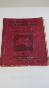
Book - Educational - School Atlas, Collins' Australian Clear School Atlas
... Kiewa Valley Historical Society Mount Beauty Information Centre 31 Bogong High Plains Rd Mt Beauty high-country Australian schools used Atlases to teach students geography and the nationalities of countries worldwide. ...Australian schools used Atlases to teach students geography and the nationalities of countries worldwide.Clare Roper was a resident of the Kiewa Valley. This atlas is of interest because it is circa 1950s and shows the world at this time.Thick red cardboard cover with black print and map of Australia on cover. It includes coloured maps of countries, black & white photos and an index at the back. On the inside of the cover both front and back it has black and white maps. There are 30 pages and it is bound. Circa 1950sCover page: handwritten "Margaret Tulloh / C. Roper / Margaret Tulloh / M.L.C. Some pages have been marked with pencilaustralian school atlas, clare roper -
 Kiewa Valley Historical Society
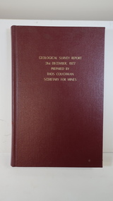
Book - Geographical Survey, Geographical Survey Report 31st Dec. 1977 prepared by Thos. Couchman Secretary for Mines
... Society Mount Beauty Information Centre 31 Bogong High Plains Rd Mt Beauty high-country Office of Mines published progressive reports on the Geological Survey of parts of Victoria. This book includes a chapter on 'Dargo and Bogong' Pages 96 - 117 and includes a fold out map of this area. These pages show heavy use. geological survey 1878 dargo bogong First chapter and some pages have pencil marks including page 97. Hard deep red cover with gold printed title located at the centre top. Bound with spine blank. 217 pages. Date 1878 Geographical ...Office of Mines published progressive reports on the Geological Survey of parts of Victoria.This book includes a chapter on 'Dargo and Bogong' Pages 96 - 117 and includes a fold out map of this area. These pages show heavy use.Hard deep red cover with gold printed title located at the centre top. Bound with spine blank. 217 pages. Date 1878 First chapter and some pages have pencil marks including page 97.geological survey 1878, dargo, bogong -
 Kiewa Valley Historical Society
Maps - Educational x 10 and Kiewa Scheme x1
... Kiewa Valley Historical Society Mount Beauty Information Centre 31 Bogong High Plains Rd Mt Beauty high-country Maps were used to teach children geography, the explorers, the minerals, the world etc. ...Maps were used to teach children geography, the explorers, the minerals, the world etc. The school bought and stored the maps so that they were available for use. This predated electronic devices. The KHE Works map was hand drawn showing lots of detail.These maps were used by the Bogong Primary School. The Kiewa Hydro Electric Works was built by the SECV and produced hydro power. This map may have been used by pupils as well as workers on the Works. Large coloured maps on canvas, with a wooden beam along the top and bottom. Each one has a cord attached to the top so that the map may be hung up on a wall. Some are made by Chas. H. Scally & Co., Baronia Ave., Wollstonecraft, N.S.W. The Kiewa Hydro Electric Works map is pinkish and shows Rocky Valley Dam, Lake Guy and Mt Beauty pondage in dark blue.maps, educational maps, geography, primary school, kiewa hydro electric works -
 Kiewa Valley Historical Society
West Kiewa Alpine Way and Day Ski Resort
... Kiewa Valley Historical Society Mount Beauty Information Centre 31 Bogong High Plains Rd Mt Beauty high-country In June 1982 This research report on the West Kiewa Alpine Way Proposal was sent to the Mt Beauty Chamber of Commerce. "The economic, tourist market and geographic ...In June 1982 This research report on the West Kiewa Alpine Way Proposal was sent to the Mt Beauty Chamber of Commerce. "The economic, tourist market and geographic factors are the kernel of the proposal." From Industrial Relocations Consultants Pty. Ltd.The proposal was to benefit the tourism industry.Manila foolscap folder with metal fastener. Papers dated June 1982 re - "Proposed West Kiewa Alpine Way and Day Ski Resort" Also enclosed but not related: Letter from Falls Creek Tourist Area Management Committee July 1984B. Goss written on coverwest kiewa alpine way, day ski resort, mt beauty chamber of commerce -
 Kiewa Valley Historical Society
Atlas Australian Commonwealth, Philips' Australian Commonwealth Atlas, 1944
... Kiewa Valley Historical Society Mount Beauty Information Centre 31 Bogong High Plains Rd Mt Beauty high-country This atlas, printed in 1944, details not only the geographic and political boundaries of the world as it was at that time but also the snap shot of life of the time. ...This atlas, printed in 1944, details not only the geographic and political boundaries of the world as it was at that time but also the snap shot of life of the time. This snap shot in time covers the major Australian cities, the major farming, grazing, industrial and sporting/recreational activities. Also there are snap shots of similar activities from other global areas. The period also covered World War II, detailed by a photo of "shell making", munitions, required by Australian soldiers. The great political and territorial changes made as a result of World War II can be clearly identified for example , Israel (the Jewish homeland). The various prewar colonies of major European nations.This atlas was used by children of a Kiewa Valley family and shows the value and the general educational exposure that these children had at this time. The rural setting and within the backdrop of a world war did not severely alter the life style of children in this region. The "news reels" shown in cinemas of cities and larger towns were the only visual realisations of major events of global significance available to these children. The information provided by this atlas allowed students to glimpse at what the "outside world" was. The majority of these students would possibly never see these regions for themselves. The great communication facilities of the late 1900s and beyond, was still only science fiction.This atlas has a thick (350 g/m) red cardboard cover with bold black lettering and shading. The cover is set out within a shield like frame. The shield is held up by two square markings, each with a four part circular pattern and a cord entwining two pendulum structures ending with a bowl figure at the bottom. There is a semi circular form enclosing a printed book contents list. The inside cover has the atlas title and contents and the publisher details. The atlas contain 56 pages of world and Australian maps, vegetation and rainfall maps. Within this atlas there are 27 double sided pages of black and white photographs depicting life styles, buildings, landscapes and prominent and significant to Australia males from 1652 to 1944. The pages are of approximately 200 g/m and have the yellow aged appearance.On front cover "Philips' Australian COMMONWEALTH ATLAS" and underneath "Containing" underneath "60 PHYSICAL, POLITICAL AND ECONOMIC MAPS". Publisher George Philip & Son, Limited 32 Fleet Street, London E.C. 4. Inside cover are: written, in freehand and in ink the following names and dates; "J.Muller Form V 1945", "L L Muller Form IV 1946", "N.J. Muller Form I + II + III 1948 +49 + 50" and "D Muller Form I 1949". also handwritten and in pencil is "Peter Leslie". On the last page is a small freehand sketch of Australia in biro.1940s school curriculum, rural education, 1940s atlas, australian atlas -
 Orbost & District Historical Society
book, James Yeates & Sons (Printing) Pty Ltd, The Silk Jetties of the Mitchell river, 1972
... Orbost & District Historical Society Ruskin Street Orbost gippsland This booklet was the first of a series of scientific and historical studies of Gippsland to be published by the Bairnsdale Advertiser. The author, Eric Charles Frederick Bird was Principal Fellow, Department of Geography ...This booklet was the first of a series of scientific and historical studies of Gippsland to be published by the Bairnsdale Advertiser. The author, Eric Charles Frederick Bird was Principal Fellow, Department of Geography, University of Melbourne, Australia. The Mitchell River silt jetties are an unusually long, thin landform located in the Gippsland Lakes region. They have been formed over millions of years by sediment deposition from the Mitchell River during periods of low water flow and subsequent wash-through during periods of high water flow. The long narrow banks of silt extend more than eight kilometres east into Lake King. This item is a useful reference for the silt jetties of the Mitchell River.A 32 pp book with alight green cover. The title is in black print, " The Silk Jetties of the Mitchell River" and underneath the title there is a b/w photograph of the Mitchell River and silt jetties taken from above in 1931. It was written by E. C. F. Bird.silt-jetties mitchell-river paynesville bird-e.c.f. -
 Orbost & District Historical Society
book, Our First 50 Years, 1985
... Orbost & District Historical Society Ruskin Street Orbost gippsland This is a souvenir edition - a reproduction of a section of an old three volume geographic encyclopaedia of Australia and New Zealand published in 1885. ...This is a souvenir edition - a reproduction of a section of an old three volume geographic encyclopaedia of Australia and New Zealand published in 1885.This book is a useful reference tool for the early history of Victory.A reproduction of a book first published in 1885. The soft cover is brown, a paler brown background and gold coloured text - Victorian Souvenir Edition Our First 50 Years. 1835 1885 is inside 50. There is a sketch of the "Lady Nelson" entering Port Phillip. It has 162 pp which are sepia toned in double columns with illustrations and maps throughout the book .history-victory book