Showing 224 items matching "topographical"
-
 Bendigo Military Museum
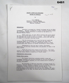
Administrative record - Geodetic Survey and Topographical Mapping in Australia - Report by BP Lambert 1968, 1968
... Geodetic Survey and Topographical Mapping in Australia - Report by BP Lambert 1968...National coordination of their respective geodetic survey and topographic mapping activities is effected on the advice of a National Mapping Council. ...Geodetic Survey and Topographic Mapping a Report by BP Lambert Director of National Mapping, Department of National Development, Canberra, Australia, 1968....National coordination of their respective geodetic survey and topographic mapping activities is effected on the advice of a National Mapping Council. ...Australia is governed by a Federal Government and by six State Governments. National coordination of their respective geodetic survey and topographic mapping activities is effected on the advice of a National Mapping Council. Twenty years ago, at least 95% of Australia was poorly mapped and what maps existed were in need of revision. only a small area of the continent was covered by horizontal geodetic control and there was no scheme for a national levelling survey. Over the intervening period there has been an urgent and increasing demand for topographic maps varying from large scale contoured maps in support of specific engineering projects to rapid reconnaissance maps required for mineral prospecting in remote areas. Superimposed on this has been a defence requirement, specifically for military training areas, and generally for maps of the whole country. During the period much progress has been made. This paper reports on the progress from early colonial days through to the present time and finally hazards a prediction of future trends.Photocopy of 18-page typed report including diagrams, stapled top left-hand corner. Geodetic Survey and Topographic Mapping a Report by BP Lambert Director of National Mapping, Department of National Development, Canberra, Australia, 1968.royal australian survey corps, rasvy, fortuna, army survey regiment, army svy regt, asr, national mapping -
 Emerald Museum & Nobelius Heritage Park
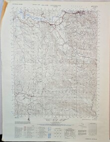
Map - Gembrook topographical map c1967, c1967
... Gembrook topographical map c1967...Image of topographical map of the Gembrook district c1967...Emerald Museum & Nobelius Heritage Park 5 Crichton Rd Emerald yarra-valley-and-the-dandenong-ranges Gembrook Victoria/Australia 1:50,000/Edition 1 - AAS/Sheet 8022-111, Edition 1, Series 754/Legend/ Image of topographical map of the Gembrook district c1967 Gembrook topographical map c1967 Map Gembrook topographical map c1967 ...Image of topographical map of the Gembrook district c1967Gembrook Victoria/Australia 1:50,000/Edition 1 - AAS/Sheet 8022-111, Edition 1, Series 754/Legend/ -
 Ringwood and District Historical Society
Map, Prepared by Commonwealth Section Imperial General Staff, Topographical map of Ringwood and surrounding areas dated 1-Aug-1935
... Topographical map of Ringwood and surrounding areas dated 1-Aug-1935....Topographical map of Ringwood and surrounding areas dated 1-Aug-1935. ...Two copies. Topographical map of Ringwood and surrounding areas dated 1-Aug-1935. ...Topographical map of Ringwood and surrounding areas dated 1-Aug-1935. Two copies.Ringwood Zone -
 Emerald Museum & Nobelius Heritage Park
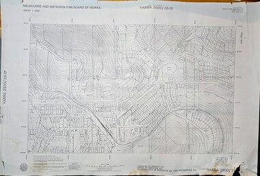
Map - Melbourne & Metropolitan Board of Works, Emerald Victoria, Topographical Map - Amendment 16.1.89, Melbourne and Metropolitan Board of Works, MMBW Topographical Map -Yarra 2500/28.01, 1989
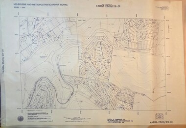
... MMBW Topographical Map -Yarra 2500/28.01...Image of printed Melbourne & Metropolitan Board of Works topographical map - Emerald - Yarra 2500/28.01...Mitchell, Chief Surveyor, Engineering Branch: May 1984/Survey Co-ordination Act plan classification BB2/Revised and re-issued/Latest cadastral amendment 16.1.89/Scale 1:2500/Township of Emerald 5280, Parish of Gembrook 2645, Municipalities of Pakenham 262 And Sherbrooke259/YARRA 2500/28.01 Image of printed Melbourne & Metropolitan Board of Works topographical map - Emerald - Yarra 2500/28.01 MMBW Topographical Map -Yarra 2500/28.01 Map Melbourne & Metropolitan Board of Works, Emerald Victoria, Topographical Map - Amendment 16.1.89 Melbourne and Metropolitan Board of Works ...Topographical map of Emerald township from 1989, based on photography from 1981Image of printed Melbourne & Metropolitan Board of Works topographical map - Emerald - Yarra 2500/28.01non-fictionTopographical map of Emerald township from 1989, based on photography from 1981emerald -
 Emerald Museum & Nobelius Heritage Park
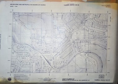
Map - Transparency edition - Melbourne & Metropolitan Board of Works, Emerald Victoria, Topographical Map - Amendment 16.1.89, Melbourne and Metropolitan Board of Works, MMBW Topographical Map -Yarra 2500/28.01, 1989
... MMBW Topographical Map -Yarra 2500/28.01...Image of printed Melbourne & Metropolitan Board of Works topographical map - Emerald - Yarra 2500/28.01...Mitchell, Chief Surveyor, Engineering Branch: May 1984/Survey Co-ordination Act plan classification BB2/Revised and re-issued/Latest cadastral amendment 16.1.89/Scale 1:2500/Township of Emerald 5280, Parish of Gembrook 2645, Municipalities of Pakenham 262 And Sherbrooke259/YARRA 2500/28.01 Image of printed Melbourne & Metropolitan Board of Works topographical map - Emerald - Yarra 2500/28.01 MMBW Topographical Map -Yarra 2500/28.01 Map Transparency edition - Melbourne & Metropolitan Board of Works, Emerald Victoria, Topographical Map - Amendment 16.1.89 Melbourne and Metropolitan Board of Works ...Topographical map of Emerald township from 1988Image of printed Melbourne & Metropolitan Board of Works topographical map - Emerald - Yarra 2500/28.01non-fictionTopographical map of Emerald township from 1988emerald -
 Emerald Museum & Nobelius Heritage Park
Map - Melbourne & Metropolitan Board of Works, Emerald Victoria, Topographical Map - Amendment 5.1.88, Melbourne and Metropolitan Board of Works, MMBW Topographical Map -Yarra 2500/29.01, 1988
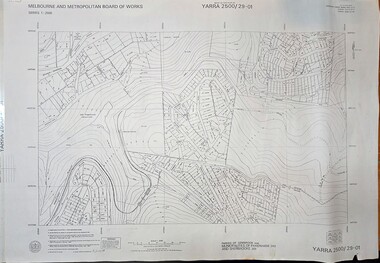
... MMBW Topographical Map -Yarra 2500/29.01...Image of printed Melbourne & Metropolitan Board of Works topographical map - Emerald - Yarra 2500/29.01...Marwick, Chief Surveyor, Engineering Branch: May 1986/Survey Co-ordination Act plan classification BB2/Revised and re-issued/Latest cadastral amendment 15.1.88/Scale 1:2500/Parish of Gembrook 2645, Municipalities of Pakenham 262 And Sherbrooke259/YARRA 2500/29.01 Image of printed Melbourne & Metropolitan Board of Works topographical map - Emerald - Yarra 2500/29.01 MMBW Topographical Map -Yarra 2500/29.01 Map Melbourne & Metropolitan Board of Works, Emerald Victoria, Topographical Map - Amendment 5.1.88 Melbourne and Metropolitan Board of Works ...Topographical map of Emerald township from 1989, based on photography from 1981Image of printed Melbourne & Metropolitan Board of Works topographical map - Emerald - Yarra 2500/29.01non-fictionTopographical map of Emerald township from 1989, based on photography from 1981emerald -
 Emerald Museum & Nobelius Heritage Park
Map - Transparency of Melbourne & Metropolitan Board of Works, Emerald Victoria, Topographical Map - Amendment 5.1.88, Melbourne and Metropolitan Board of Works, MMBW Topographical Map -Yarra 2500/29.01, 1988
... MMBW Topographical Map -Yarra 2500/29.01...Image transparency of printed Melbourne & Metropolitan Board of Works topographical map - Emerald - Yarra 2500/29.01...Marwick, Chief Surveyor, Engineering Branch: May 1986/Survey Co-ordination Act plan classification BB2/Revised and re-issued/Latest cadastral amendment 15.1.88/Scale 1:2500/Parish of Gembrook 2645, Municipalities of Pakenham 262 And Sherbrooke259/YARRA 2500/29.01 Image transparency of printed Melbourne & Metropolitan Board of Works topographical map - Emerald - Yarra 2500/29.01 MMBW Topographical Map -Yarra 2500/29.01 Map Transparency of Melbourne & Metropolitan Board of Works, Emerald Victoria, Topographical Map - Amendment 5.1.88 Melbourne and Metropolitan Board of Works ...Topographical map of Emerald township from 1988Image transparency of printed Melbourne & Metropolitan Board of Works topographical map - Emerald - Yarra 2500/29.01non-fictionTopographical map of Emerald township from 1988emerald -
 Bendigo Military Museum
Map - Panorama sketch from Heath Trench Sector Factory Farm to Messines, 11 April 1917
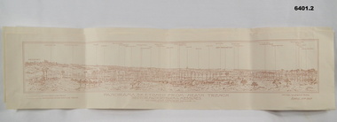
... Panoramic sketch by George W Bleach A 2nd Anzac Topographical Section. April 11th 1917. View from Heath Trench. ...By George W Bleach A 2nd Anzac Topographical Section. April 11th 1917.... George W Bleach A 2nd Anzac Topographical Section. April 11th 1917....Bendigo Military Museum 37 - 39 Pall Mall Bendigo goldfields Panoramic sketch by George W Bleach A 2nd Anzac Topographical Section. April 11th 1917. View from Heath Trench. ...Panoramic sketch by George W Bleach A 2nd Anzac Topographical Section. April 11th 1917. View from Heath Trench. Co-ords of O.P.U13.b 30.20Panoramic view of Messines. Printed on cream card. Sepia image. By George W Bleach A 2nd Anzac Topographical Section. April 11th 1917. George W Bleach A 2nd Anzac Topographical Section. April 11th 1917.panoramic view of messines -
 Bendigo Military Museum
Map - Australian Topographical Survey NAGAMBIE SW Sheet, 1 inch:1 Mile, NW portion Plane Table Field sheet 1921, Australian Survey Corps, 1921
... Australian Topographical Survey NAGAMBIE SW Sheet, 1 inch:1 Mile, NW portion Plane Table Field sheet 1921...Reprinted coloured Image of Australian Topographical Survey NAGAMBIE SW Sheet,1 inch:1 Mile, NW portion hand drawn Plane Table Field sheet. ...Includes an itemized summary of work, signed by Sgt J Cullen Australian Survey Corps September1921. Australian Topographical Survey NAGAMBIE SW Sheet, 1 inch:1 Mile, NW portion Plane Table Field sheet 1921 Map Australian Topographical Survey NAGAMBIE SW Sheet, 1 inch:1 Mile, NW portion Plane Table Field sheet 1921 Australian Survey Corps ...This is a coloured reproduction print of an original Plane Table compilation map sheet of Nagambie area 1inch to 1 Mile scale compiled by Sgt Jack Cullen Australian Survey Corps 30 September 1921. Jack was one of the foundation members of the Australian Survey Corps. Of particular interest is the fact that this is a heighted compilation with contouring (required for Military use) as many early maps were purely planimetric. A table on the right hand side details the number of days that it took to produce the compilation. The reverse side of this print is a copy of the Tallarook plane table South East field sheet.Reprinted coloured Image of Australian Topographical Survey NAGAMBIE SW Sheet,1 inch:1 Mile, NW portion hand drawn Plane Table Field sheet. Includes an itemized summary of work, signed by Sgt J Cullen Australian Survey Corps September1921.royal australian survey corps, rasvy, fortuna, army survey regiment, army svy regt, asr -
 Bendigo Military Museum
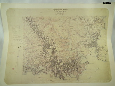
Map - Australian Topographical Survey SYDNEY / 56III Southern Half, NE Plane Table Field sheet 1915, Australian Survey Corps, 6 Dec 1915
... Australian Topographical Survey SYDNEY / 56III Southern Half, NE Plane Table Field sheet 1915...Reprinted coloured Image of Australian Topographical Survey SYDNEY /56 III Southern Half, hand drawn NE Plane Table field sheet. ...Includes an itemized summary of work performed by HA Roseblade CSM Australian Survey Corps 1915, Signed by J Lynch Lieutenant. Australian Topographical Survey SYDNEY / 56III Southern Half, NE Plane Table Field sheet 1915 Map Australian Topographical Survey SYDNEY / 56III Southern Half, NE Plane Table Field sheet 1915 Australian Survey Corps ...This is a unique example of a hand drawn plane table sheet produced in the first year of the Australian Survey Corps by original members of the Corps. Roseblade and Lynch 5 Dec 1915. Of interest is the documented times that it took to create the original field sheet. Also of interest is the fact that this field sheet that was used to create the actual SYDNEY map sheet was contoured, many map sheets produced up until now were purely planimetric and lacked contouring that was needed for military use. This is a reproduction print of a photograph of the original field sheet and was printed at the Army Survey Regiment, Bendigo.Reprinted coloured Image of Australian Topographical Survey SYDNEY /56 III Southern Half, hand drawn NE Plane Table field sheet. Includes an itemized summary of work performed by HA Roseblade CSM Australian Survey Corps 1915, Signed by J Lynch Lieutenant.royal australian survey corps, rasvy, fortuna, army survey regiment, army svy regt, asr -
 Bendigo Military Museum
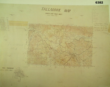
Map - Australian Topographical Survey TALLAROOK SE Sheet, 1 inch:1 Mile, NW portion Plane Table Field sheet 1923, Australian Survey Corps, 1923
... Australian Topographical Survey TALLAROOK SE Sheet, 1 inch:1 Mile, NW portion Plane Table Field sheet 1923...Reprinted coloured Image of Australian Topographical Survey TALLAROOK SE field Sheet,1 inch:1 Mile, hand drawn contoured Plane Table Field sheet. ...An enlargement of YEA Township 2 Inches to 1 Mile Scale. Australian Topographical Survey TALLAROOK SE Sheet, 1 inch:1 Mile, NW portion Plane Table Field sheet 1923 Map Australian Topographical Survey TALLAROOK SE Sheet, 1 inch:1 Mile, NW portion Plane Table Field sheet 1923 Australian Survey Corps ...This is a coloured reproduction print of an original Plane Table compilation map sheet of Tallarook area 1inch to 1 Mile scale compiled by Sgt Jack Cullen Australian Survey Corps 12 November 1923 and signed by Capt J Lynch. Capt Lynch and Sgt Cullen were both foundation members of the Australian Survey Corps. Of particular interest is the fact that this is a heighted compilation with contouring (required for Military use) as many early maps were purely planimetric. The reverse side of this print is a copy of the Nagambie plane table South West field sheet.Reprinted coloured Image of Australian Topographical Survey TALLAROOK SE field Sheet,1 inch:1 Mile, hand drawn contoured Plane Table Field sheet. Signed by Sgt J Cullen Australian Survey Corps November1923. An enlargement of YEA Township 2 Inches to 1 Mile Scale.royal australian survey corps, rasvy, fortuna, army survey regiment, army svy regt, asr -
 Bendigo Military Museum
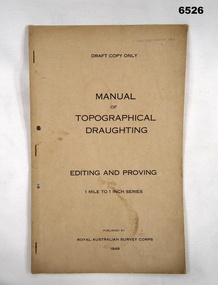
Document - Royal Australian Survey Corps - Manual of Topographical Draughting - Editing and Proving 1949, Royal Australian Survey Corps, 1949
... Royal Australian Survey Corps - Manual of Topographical Draughting - Editing and Proving 1949...This Draft document is part of the Topographical Drafting Manual produced by the Royal Australian Survey Corps in 1949. ...Bendigo Military Museum 37 - 39 Pall Mall Bendigo goldfields This Draft document is part of the Topographical Drafting Manual produced by the Royal Australian Survey Corps in 1949. ...This Draft document is part of the Topographical Drafting Manual produced by the Royal Australian Survey Corps in 1949. This document covers the guidelines for Editing and Proving (quality control) of the 1 Mile to 1 Inch map series that was widely produced by the Corps over Australia.A 10 x page foolscap sized buff coloured covered document, stapled and two hole punchedStamped on cover "E Comd Field Survey Unit"royal australian survey corps, rasvy, fortuna, army survey regiment, army svy regt, asr -
 Kiewa Valley Historical Society
Maps - Bogong x2, Tawonga, Omeo, Dargo, Victoria and others, 1. Bogong Alpine Area; 2. Bogong 8324; 3. Tawonga Topographical; 4. Omeo 8433; 5. Dargo 8323; 6. Victoria State
... Bogong 8324; 3. Tawonga Topographical; 4. Omeo 8433; 5. Dargo 8323; 6. ...Map has a red cover with white writing together with a white block and black writing and a map insert. 3. Tawonga Topographical Map - Forests Commission Victoria, / revised 5/9/77, DEG No. 68-G/399. ...Bogong 8324; 3. Tawonga Topographical; 4. Omeo 8433; 5. Dargo 8323; 6. ...1. Bogong Alpine Area (outdoor Leisure Map. survey & Mapping Victoria, Government of Victoria, Edition 2, reprinted 1991 with an image of Mt. Feathertop on the front. Information for tourist in the Alpine National Park: Bogong Area. Including: recreational activities, history, weather and vegetation and a list of walks together with locality maps and photographs. The front cover has an image of Mt Feathertop against a blue sky with yellow writing 'Bogong Alpine Area', there is a yellow triangular block on the right hand top corner with black writing 'Outdoor Leisure Map. On the bottom edge is a block of yellow with black writing 'Survey & Mapping Victoria' and a light green map of Victoria with 'VICMSP' printed in white. 2. 8324 Bogong Victoria, Edition 1, Commonwealth of Australia 1981. A topographical Map: 1:100,000 scale (1 cm to 1 KM). Map has a red cover with white writing together with a white block and black writing and a map insert. 3. Tawonga Topographical Map - Forests Commission Victoria, / revised 5/9/77, DEG No. 68-G/399. A Tawonga 803 folded map in a beige colour with the back blank. 4. Omeo 8433 Victoria, Edition 1, Department of Natural Resources. The map has a red and white cover with black writing and a simple map of Australia at the bottom. 5. 8323 Dargo, Edition 1, Commonwealth of Australia. A red and white cover with a map insert. 6. Victoria State Map, Hema Maps, 2002. Hema Maps, State Map, colourful cover with a map of Australia and four tourism photographs. Scale 1: 850,000 An inscription handwritten in blue pen "Trappers Gap to Mitta Mitta 1" to 1 mile". There are some pen markings and notations of tracks.maps, bogong, omeo, tawonga, dargo, victoria, bogong alpine area -
 Sunshine and District Historical Society Incorporated
Map - Melton Topographic Map, Vicmap, 1979
... Printed topographic map of the Melton region...Melton 7822-4-3 Zone 55 1:25000 1979 Topographic Map...Melton Map Melton 7822-4-3 Zone 55 1:25000 1979 Topographic Map Printed topographic map of the Melton region Map Melton Topographic Map Vicmap ...Melton 7822-4-3 Zone 55 1:25000 1979 Topographic Mapmelton, map -
 Sunshine and District Historical Society Incorporated
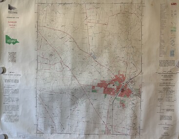
Map - Sunbury Topographic Map, Vicmap, 1989
... Printed topographic map of the Sunbury region...Sunbury 7822-4-1 Zone 55 1:25000 1989 Topographic Map...Sunbury Map Sunbury 7822-4-1 Zone 55 1:25000 1989 Topographic Map Printed topographic map of the Sunbury region Map Sunbury Topographic Map Vicmap ...Sunbury 7822-4-1 Zone 55 1:25000 1989 Topographic Mapsunbury, map -
 Sunshine and District Historical Society Incorporated
Map - Eynesbury Topographic Map, Vicmap, 1982
... Printed topographic map of the Eynesbury region...Eynesbury 7822-3-2 Zone 55 1:25000 1982 Topographic Map...Eynesbury Map Eynesbury 7822-3-2 Zone 55 1:25000 1982 Topographic Map Printed topographic map of the Eynesbury region Map Eynesbury Topographic Map Vicmap ...Eynesbury 7822-3-2 Zone 55 1:25000 1982 Topographic Mapeynesbury, map -
 Sunshine and District Historical Society Incorporated
Map - Sydenham West Topographic Map, Vicmap, 1977
... Printed topographic map of the Sydenham West region...Sydenham West 7822-4-2 Zone 55 1:25000 1977 Topographic Map...Sydenham West Topographic Club Topographic Map Document Sydenham West 7822-4-2 Zone 55 1:25000 1977 Topographic Map Printed topographic map of the Sydenham West region Map Sydenham West Topographic Map Vicmap ...Sydenham West 7822-4-2 Zone 55 1:25000 1977 Topographic Mapsydenham west topographic club, topographic, map document -
 Bendigo Military Museum
Poster, A Section/Topographical Survey Troop in South Vietnam in the 1960/70's
... A Section/Topographical Survey Troop in South Vietnam in the 1960/70's....Poster POSTER A Section/Topographical Survey Troop in South Vietnam in the 1960/70's. ...Print on Poster " FLY FAR-FAREASTERN AIRWAYS/this /vacation visit/ beautiful/ VIETNAMPoster - white paper, black and red print, illustrated in black and red - stylized picture of two soldiers in a battle. Green and Yellow coloured background.poster, vietnam, travel -
Federation University Historical Collection
Book, The Institution of Mining and Metallurgy: List of members (with topographical index, etc., 1923, 1923
... The Institution of Mining and Metallurgy: List of members (with topographical index, etc., 1923...The Institution of Mining and Metallurgy: List of members (with topographical index, etc., 1923 Book Crowther & Goodman, Ltd Crowther & Goodman, Ltd ...Ballarat School of Mines graduate, Reginald Brooks, is listed as a member from Melbourne. Also J.V. Lake from Ballarat, J.W. Sutherland from Boulder, John Adam from GwalaBuff soft covered book.j.v. lake, reginald brook, institution of mining and metallurgy, john adam, j.w. sutherland -
Federation University Historical Collection
Book, The Institution of Mining and Metallurgy: Constitution and By-Laws and List of Members (with topographical Index), 1913, 1913
... The Institution of Mining and Metallurgy: Constitution and By-Laws and List of Members (with topographical Index), 1913...The Institution of Mining and Metallurgy: Constitution and By-Laws and List of Members (with topographical Index), 1913 Book Crowther & Goodman, Ltd Crowther & Goodman, Ltd ...W. Poole and J.W. Tank from Ballarat is listed as members, as is J.W. Sutherland from Boulder.Buff soft covered book.institution of mining and metallurgy, w. poole, j.w. tank, j.w. sutherland -
Federation University Historical Collection
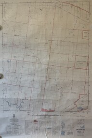
Map, Topographical Map Creswick A & B
... Topographical Map Creswick A & B...Barker Library (top floor) Mount Helen goldfields creswick clunes lexton waubra smeaton Printed map on paper Topographical Map Creswick A & B Map Map Department of Lands and Survey ...Printed map on papercreswick, clunes, lexton, waubra, smeaton -
Stawell Historical Society Inc
Map, Stawell Gold Mine, Plan of Surface Topographical Detail, 27 March 2007
... Plan of Surface Topographical Detail...Stawell Historical Society Inc 46 Longfield St Stawell grampians mining gold Stawell Gold Mines Stawell Victoria Showing Magdala Decline as at 27 March 2007 Plan of Surface Topographical Detail Map Stawell Gold Mine ...Stawell Victoria Showing Magdala Decline as at 27 March 2007 Stawell Gold Mines mining, gold -
 Sunshine and District Historical Society Incorporated
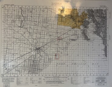
Map - Melbourne Topographical Map No 848 Zone 7, 1930
... Laminated Melbourne Topographical Map No 848 Zone 7 showing Melbourne : Footscray : Williamstown : Maidstone : Sunshine : Deer Park : Laverton : Werribee : Port Phillip Map...Melbourne Topographical Map No 848 Zone 7|Point Cook Airfield, Laverton Airfield and No 1 Stores Tottenham marked on the map....Melbourne Map Melbourne Topographical Map No 848 Zone 7|Point Cook Airfield, Laverton Airfield and No 1 Stores Tottenham marked on the map. ...Melbourne Topographical Map No 848 Zone 7|Point Cook Airfield, Laverton Airfield and No 1 Stores Tottenham marked on the map.melbourne, map -
 National Vietnam Veterans Museum (NVVM)
Map - Framed map, Xuyen Moc (SW)
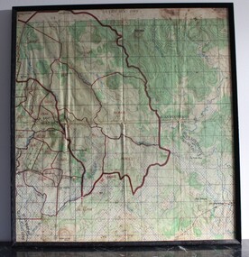
... Part of a single sheet from the Vietnam 1:25 000 topographical map series (L7014) covering the area around the town of Xuyen Moc in the southern province of Phuoc Tuy (modern Ba Ria - Vung Tau). ...Square topographical map with district boundaries, vegetation and terrain features. ...Xuyen Moc Phuoc Tuy map Vungtau Vung tau Ba Ria Sheet 6430-11-SW/ Edition 2/Series L 8015 Square topographical map with district boundaries, vegetation and terrain features. ...Part of a single sheet from the Vietnam 1:25 000 topographical map series (L7014) covering the area around the town of Xuyen Moc in the southern province of Phuoc Tuy (modern Ba Ria - Vung Tau). Used during the war, this shows Areas of Operations given men's names.Square topographical map with district boundaries, vegetation and terrain features. Relief shown by contours. Has been laminated and framed.Sheet 6430-11-SW/ Edition 2/Series L 8015xuyen moc, phuoc tuy, map, vungtau, vung tau, ba ria -
 National Vietnam Veterans Museum (NVVM)
Photograph - Nui Dat images
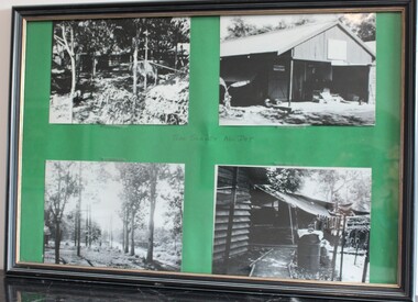
... ...Topographical...They were taken by Sapper Bruce Appleford, A Section, 1st Topographical Survey Troop 1970-71. ...They were taken by Sapper Bruce Appleford, A Section, 1st Topographical Survey Troop 1970-71. Nui Dat Appleford B r Appleford Topographical 'TOPO SURVEY NUI DAT' in blue ink, hand written in centre of the four photos. ...These images contribute to an understanding of the type of camps that were set up in Nui Dat during the conflict in Vietnam between 1962 - 1972. They were taken by Sapper Bruce Appleford, A Section, 1st Topographical Survey Troop 1970-71. A black plastic frame with four black and white images of camp at Nui Dat stuck on a green card mat. Left side: Camp in trees & Treed area near road. Right side: Shed, Camp'TOPO SURVEY NUI DAT' in blue ink, hand written in centre of the four photos.nui dat, appleford, b r appleford, topographical -
 Bendigo Military Museum
Newspaper - Army Survey Regiment farewells Bendigo
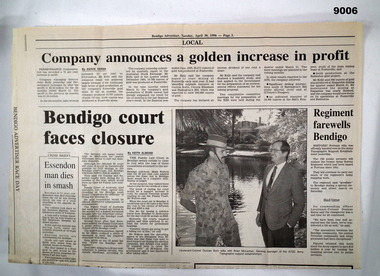
... A single folded page (Page 3) of the Bendigo Advertiser dated 30 April 1996 containing an article about the Army Survey Regiment handing over to the Army Topographic Support Establishment (ATSE). As part of the CSP competitive tendering process, the ATSE Australian Public Service organisation was awarded the contract to continue to provide geographic support to the Australian Defence Force. ...A single folded page (Page 3) of the Bendigo Advertiser dated 30 April 1996 containing an article about the Army Survey Regiment handing over to the Army Topographic Support Establishment (ATSE)...Bendigo Military Museum 37 - 39 Pall Mall Bendigo goldfields A single folded page (Page 3) of the Bendigo Advertiser dated 30 April 1996 containing an article about the Army Survey Regiment handing over to the Army Topographic Support Establishment (ATSE). As part of the CSP competitive tendering process, the ATSE Australian Public Service organisation was awarded the contract to continue to provide geographic support to the Australian Defence Force. ...A single folded page (Page 3) of the Bendigo Advertiser dated 30 April 1996 containing an article about the Army Survey Regiment handing over to the Army Topographic Support Establishment (ATSE). As part of the CSP competitive tendering process, the ATSE Australian Public Service organisation was awarded the contract to continue to provide geographic support to the Australian Defence Force. This article is about the handover.A single folded page (Page 3) of the Bendigo Advertiser dated 30 April 1996 containing an article about the Army Survey Regiment handing over to the Army Topographic Support Establishment (ATSE)royal australian survey corps, rasvy, fortuna, army survey regiment, army svy regt, atse -
Warrnambool RSL Sub Branch
BOB: Map France 1:100,000 AMIENS, AMIENS, Geographical Section, General Staff, No 2364. October 1915; Ordnance Survey 1916; Minor Corrections 01/10/1916
... Topographical map. Full colour ...(Bob) Snape, Reg No 8651, enlisted as a Stretcher Bearer in 1915 but, because of his secretarial skills was employed in HQ positions as soon as he arrived in France and as a stenographer who worked as Confidential Clerk to General Sir John Monash from June to December 1918; and subsequently, for General Sir Tread more Snape Collection Topographical map. Full colour AMIENS BOB: Map France 1:100,000 AMIENS ...Original Item souvenired from possibly Australian Corps HQ, probably between the Armistice, 11 November 1918, and June 1919, when the Staff Sergeant R.O.(Bob) Snape was repatriated.The donor, Staff Sergeant R.O. (Bob) Snape, Reg No 8651, enlisted as a Stretcher Bearer in 1915 but, because of his secretarial skills was employed in HQ positions as soon as he arrived in France and as a stenographer who worked as Confidential Clerk to General Sir John Monash from June to December 1918; and subsequently, for General Sir Tread moreTopographical map. Full colour snape collection -
 Running Rabbits Military Museum operated by the Upwey Belgrave RSL Sub Branch
Map
... Topographic map of Nui Dat...Running Rabbits Military Museum operated by the Upwey Belgrave RSL Sub Branch 1 Mast Gully Road Upwey melbourne Maps Vietnam Army Topographic map of Nui Dat Map ...Topographic map of Nui Datmaps, vietnam, army -
 Sunshine and District Historical Society Incorporated
Map - Truganina Topographic Map, Vicmap, 1981
... Printed topographic map of the Truganina region...Truganina Map Ballarat Road Eynesbury 7822-3-1 Zone 55 1:25000 1981Topographic Map Printed topographic map of the Truganina region Map Truganina Topographic Map Vicmap ...Eynesbury 7822-3-1 Zone 55 1:25000 1981Topographic Maptruganina, map, ballarat road -
Stawell Historical Society Inc
Map, Topographic Map Stawell North
... Topographic Map 1:25000 Coloured 1990...Stawell Historical Society Inc 46 Longfield St Stawell grampians Mapping Stawell North 7423-1-N Topographic Map 1:25000 Coloured 1990 Topographic Map Stawell North Map ...Topographic Map 1:25000 Coloured 1990Stawell North 7423-1-Nmapping