Showing 218 items matching "township planning"
-
 Whitehorse Historical Society Inc.
Document, Division of Survey and Mapping, 1984
... Information guide to Parish and Township Plans - Division of Survey and Mapping - Victorian Government.....Information guide to Parish and Township Plans - Division of Survey and Mapping - Victorian Government.. ...Information guide to Parish and Township Plans - Division of Survey and Mapping - Victorian Government..Information guide to Parish and Township Plans - Division of Survey and Mapping - Victorian Government..Information guide to Parish and Township Plans - Division of Survey and Mapping - Victorian Government..crown lands, victorian government, land surveys -
 Lakes Entrance Historical Society
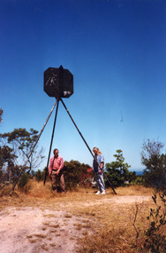
Photograph - Lakes Entrance Grid location, 1999
... ...Township Planning...(Grid ref B'dale 8422) Surveying Township Planning Colour photograph of the Victoria Geodetic Survey Triangulation Station, Trig Station, situated off Ocean View Parade, Merrangbaur Hill. ...Lakes Entrance Grid reference, Cunninghame 8522.3.4 896.082, on ten acre site with trig point, it is from this point that all the survey for the surrounding areas was undertaken. Part of the Vic Geodetic Survey initiated in 1860 by Ellery Survey started from triangulation base in Werribee. (Grid ref B'dale 8422)Colour photograph of the Victoria Geodetic Survey Triangulation Station, Trig Station, situated off Ocean View Parade, Merrangbaur Hill. Location is indicated by ground point and standing structure, situated on an elevated bush block. Lakes Entrance Victoriasurveying, township planning -
 Lakes Entrance Historical Society
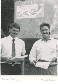
Photograph, Lake Tyers Beach Strategy Plan. Lake Tyers Beach progress Association
... ...Township Planning...Second photo of Joe Taylor at his farewell Clubs Township Planning Black and white photograph of Cr. ...Launch of Lake Tyers Beach Strategy Plan . Second photo of Joe Taylor at his farewell Black and white photograph of Cr. Barry Secomb (Tambo Shire), Mark Stone(Regional Manager DCE) . Plus second photo of members of Lake Tyers Beach progress Association clubs, township planning -
Lakes Entrance Historical Society
Map - Distribution of Carparking Shire of Tambo 1985, 1985
... ...Township Planning...Lakes Entrance Historical Society 4 Marine Parade Lakes Entrance gippsland Township Township Planning Distribution of Car parking Lakes Entrance 1985 Map Distribution of Carparking Shire of Tambo 1985 ...Distribution of Car parking Lakes Entrance 1985township, township planning -
 Lakes Entrance Historical Society
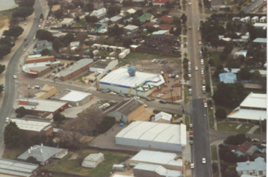
Photograph - Dahlsens Mitre 10, Church Street, Lakes Entrance Victoria, 1/07/1994 12:00:00 AM
... ...Township Planning...Lakes Entrance Historical Society 4 Marine Parade Lakes Entrance gippsland Businesses Roads and Streets Township Planning Colour photograph of businesses and residences adjacent to the newly opened Dahlsens Mitre 10 store Church Street Lakes Entrance Victoria. ...Colour photograph of businesses and residences adjacent to the newly opened Dahlsens Mitre 10 store Church Street Lakes Entrance Victoria. Also a second aerial photograph showing closer view of Mitre 10 store slightly blurred businesses, roads and streets, township planning -
Lakes Entrance Historical Society
Plan - Plan of Subdivision Cabarita Point, Crowther and Sadler Pty Ltd, 20/1/2010
... ...Township Planning...Land Development Housing Township Planning Shows allotments on Cabarita Point Road. ...Shows allotments on Cabarita Point Road. Also shows Creighton Street and Albatross Road Kalimna Victoria. 2 pagesland development, housing, township planning -
Lakes Entrance Historical Society
Plan - Satellite View Cabarita Point, Crowther and Sadler Pty Ltd, 20/1/2010
... ...Township Planning...Land Development Housing Township Planning Aerial view of Cabarita Point location and property boundary including measurements of fence lines and building area. 2 pages A and B Plan Satellite View Cabarita Point Crowther and Sadler Pty Ltd ...Aerial view of Cabarita Point location and property boundary including measurements of fence lines and building area. 2 pages A and Bland development, housing, township planning -
Lakes Entrance Historical Society
Plan - Plan of Subdivision Cabarita Point 2010, Crowther and Sadler Pty Ltd, 20/1/2010
... ...Township Planning...Land Development Housing Township Planning Shows allotments in Cabarita Point Road, Creighton Street, Albatross Road, Kalimna Victoria 2 copies A and B. 6 pages Plan Plan of Subdivision Cabarita Point 2010 Crowther and Sadler Pty Ltd ...Shows allotments in Cabarita Point Road, Creighton Street, Albatross Road, Kalimna Victoria 2 copies A and B. 6 pagesland development, housing, township planning -
 Bendigo Historical Society Inc.
Document - PLANS FROM LAND OFFICE , BENDIGO
... Four pages listing of parishes and two pages listing of Township plans....Four pages listing of parishes and two pages listing of Township plans. Document PLANS FROM LAND OFFICE , BENDIGO ...Royal Historical Society of Victoria Bendigo and district branch. Plans from Land office, Bendigo. Four pages listing of parishes and two pages listing of Township plans.land office, royal historical society -
Federation University Historical Collection
Map, Town of Buninyong, 1927, 09/1927
... Township plan of the Town of Buninyong showing government roads and crown allotments. ...Buninyong was created a district on 09 July 1858, proclaimed a Shire on 16 February 1864, and the Buninyong Borough united on 01 October 1915. buninyong map buninyong botanical gardens tannery dam buninyong reservoir chapel school rev. hastie Township plan of the Town of Buninyong showing government roads and crown allotments. ...The date of this map is September 1927 revised from the original 1910 map. Buninyong was created a district on 09 July 1858, proclaimed a Shire on 16 February 1864, and the Buninyong Borough united on 01 October 1915.Township plan of the Town of Buninyong showing government roads and crown allotments. Earlier detail pencilled on (commercial buildings, etc) appears to be from an 1850 survey. Scale: 4 chains to 1 inch (1:3168)buninyong, map, buninyong botanical gardens, tannery dam, buninyong reservoir, chapel school, rev. hastie -
Lakes Entrance Historical Society
Map - Township of Lakes Entrance
... Plan of township showing property owners names...Lakes Entrance Historical Society 4 Marine Parade Lakes Entrance gippsland Township Waterways land owners Plan of township showing property owners names Map Township of Lakes Entrance ...Plan of township showing property owners namestownship, waterways, land owners -
Lakes Entrance Historical Society
Map - Plan of Township of Lakes Entrance
... Plan of Township of Lakes Entrance...Plan of township of Lakes Entrance showing waterways and land owners...Lakes Entrance Historical Society 4 Marine Parade Lakes Entrance gippsland Township Waterways Maps Plan of township of Lakes Entrance showing waterways and land owners Map Plan of Township of Lakes Entrance ...Plan of township of Lakes Entrance showing waterways and land ownerstownship, waterways, maps -
Bendigo Historical Society Inc.
Map - RAVENSWOOD, April 6th 1872
... Map: Township of Ravenswood. Parish plan, has a 1913 calendar as a backing (number 266 in map cupboard 1)...History House 11 Mackenzie Street Bendigo goldfields MAP Bendigo township Ravenswood Map: Township of Ravenswood. Parish plan, has a 1913 calendar as a backing (number 266 in map cupboard 1) Map RAVENSWOOD ...Map: Township of Ravenswood. Parish plan, has a 1913 calendar as a backing (number 266 in map cupboard 1)map, bendigo, township, ravenswood -
Kiewa Valley Historical Society
Papers - Mt Beauty Airport Development
... Set of papers titled 'Department of Transport' and 'Alpine Shire' both held together by one staple. 3.Mt Beauty Township Survey Plan of Airstrip 1975 4. Large folder titled Mr J. ...Set of papers titled 'Department of Transport' and 'Alpine Shire' both held together by one staple. 3.Mt Beauty Township Survey Plan of Airstrip 1975 4. Large folder titled Mr J. ...The SECV began investigating four possible sites for an airstrip in Mt Beauty in 1965. The land was owned by the SEC and leased by Mr J. Sharp. It became available on the condition that the land would only be available to the Municipal shire. This land was officially opened as an Airport as an official tourist activity in 1977. It continues to be available to tourists, fire fighters, the air ambulance and the local gliding club.The opening of Mt Beauty Airport has enhanced Mt Beauty township by enabling fire fighters to access the surrounding bush during bush fires, by enabling Ambulance helicopters to rush emergency patients to city hospital, by giving tourists the opportunity to fly in and to give the local Gliding Club the opportunity to store and fly their gliders. 1. Set of papers titled 'History Mt Beauty Airport Development' held together by large steel clip by Alex McCullough. 2. Set of papers titled 'Department of Transport' and 'Alpine Shire' both held together by one staple. 3.Mt Beauty Township Survey Plan of Airstrip 1975 4. Large folder titled Mr J. R. Sharp 1975 - Mt Beauty Airfieldmt beauty airport history, alex mccullough, transport, tourism -
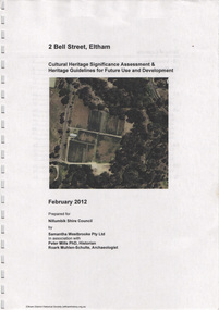 Eltham District Historical Society Inc
Document, Samantha Westbrooke Pty Ltd et al, 2 Bell Street, Eltham: Cultural Heritage Significance Assessment & Heritage Guidelines for Future Use & Development, 2012
... The site for the village of Eltham was surveyed in 1851 and the Township Plan shows that the property is made up of Lots 7 and 8 which were sold at auction in June 1852 to M. ...The site for the village of Eltham was surveyed in 1851 and the Township Plan shows that the property is made up of Lots 7 and 8 which were sold at auction in June 1852 to M. ...Prepared for Nillumbik Shire Council by Samantha Westbrooke Pty Ltd in association with Peter Mills PhD, Architectural Historian and Roark Muhlen-Schilte, Archaeologist. Covers history of early market gardening in Eltham with the commencement of European settlement in the late 1830s. The site for the village of Eltham was surveyed in 1851 and the Township Plan shows that the property is made up of Lots 7 and 8 which were sold at auction in June 1852 to M. O'Shea. The history of the Bell Street property is closely tied to the West family from the 1860s to 1930s; the earliest rate books for Eltham show William West farming in El;tham in 1864. In the aerly 1930s ownership of the creek side was transferred from the west family to the Fabbro family who shortly afterwards were impaced by the 1934 Diamond Creek flooding. Guido Fabbro relocated the original West home further up the hill and built a new Italianate style modern home in situ. The Fabbro family farmed the property. In 1993/4 Eltham Council acquired the creek-side market garden blocks to the south of 2 Bell Street which was recconceived in 1998 as the Barak Bushland Reserve. The Fabbro house was demolished shortly after and the lots were sold to a developer in 1994. The large steel shed now present on the 2 Bell Street property dates from soon after this sale.26 A4 pages color printcultural heritage significance assessment, peter mills, samantha westbrooke pty ltd, shire of nillumbik, 2 bell street, eltham, market gardening, west family, fabbro family, land use, barak bushland reserve, heritage assessment -
 Warrnambool and District Historical Society Inc.
Documents, Swintons Paper att 18/53 Merri St. Contract. Map. Notes, 1959
... .2 ‘Plan of Survey of Part of Crown Allotment 18 Section 3 Township of .2 ‘Plan of Survey of Part of Crown Allotment 18 Section 3 Township of Warrnambool Parish of Wangoom County of Villiers’ .3 ‘Tuesday Dear Mr Swinton I am writing to say that I would like to have the ‘Office’ Thanking You George O’Grady’...The current Swinton business in Timor Street is the oldest family business in Warrnambool and, with the name Swinton associated with businesses in Timor Street Warrnambool for 152 years it is amongst the oldest family businesses in Australia. swinton family, warrnambool .2 ‘Plan of Survey of Part of Crown Allotment 18 Section 3 Township of .2 ‘Plan of Survey of Part of Crown Allotment 18 Section 3 Township of Warrnambool Parish of Wangoom County of Villiers’ .3 ‘Tuesday Dear Mr Swinton I am writing to say that I would like to have the ‘Office’ Thanking You George O’Grady’ The items here relate to the sale of land by Swintons Pty Ltd., Warrnambool. .1 These are three pages of white paper with typed material, a lawyer’s signature in blue ink, one green stamp and a sketch of the land location. .2 This is a sheet of thick paper containing a plan of the land sold. ...These documents relate to the sale of land in Merri Street Warrnambool in 1959 by Swintons Pty Ltd of Warrnambool. The buyer of the land was George O’Grady, a Warrnambool baker. The land sold for £4000 and there was a shed on the land (called the ‘Office’) which George O’Grady indicated he wished to be included in the sale. William and Ann Swinton migrated to Australia in 1854 and for a decade William Swinton worked as a builder and carpenter in the Warrnambool area, erecting many buildings, including the Wangoom Presbyterian Church. In 1865 he opened a store in Timor Street Warrnambool, selling groceries, hardware, china and glassware. By 1888 the business was known as William Swinton and Sons. Branch stores were opened in Wangoom, Cudgee, Nullawarre, South Warrnambool and West Warrnambool. After William Swinton died his son Robert became the first managing director of Swintons Pty Ltd. In 1934 the business split with George Swinton and Sons selling clothing, furnishings and glassware and Swintons Pty Ltd selling seeds, produce and hardware. Today the Swinton family still operates a furniture and bedding shop in Timor St Warrnambool.These items are of some interest as being connected to the Warrnambool business of Swintons Pty Ltd. They will be of interest to researchers. The current Swinton business in Timor Street is the oldest family business in Warrnambool and, with the name Swinton associated with businesses in Timor Street Warrnambool for 152 years it is amongst the oldest family businesses in Australia.The items here relate to the sale of land by Swintons Pty Ltd., Warrnambool. .1 These are three pages of white paper with typed material, a lawyer’s signature in blue ink, one green stamp and a sketch of the land location. .2 This is a sheet of thick paper containing a plan of the land sold. The paper has printed material and a sketch of the land with part of it coloured in pink. .3 This is a small piece of paper torn at the bottom right edge. It has handwritten material (a letter) in blue ink..2 ‘Plan of Survey of Part of Crown Allotment 18 Section 3 Township of .2 ‘Plan of Survey of Part of Crown Allotment 18 Section 3 Township of Warrnambool Parish of Wangoom County of Villiers’ .3 ‘Tuesday Dear Mr Swinton I am writing to say that I would like to have the ‘Office’ Thanking You George O’Grady’swinton family,, warrnambool -
 Warrnambool and District Historical Society Inc.
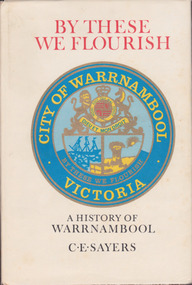
Book, C. E. Sayers, By These We Flourish A History of Warrnambool, 1969
... Endpapers have a black and white 1840s sketch of a Plan of Township and Warrnambool Bay. There are 21 chapters and 16 pages of black and white photographs. ...Endpapers have a black and white 1840s sketch of a Plan of Township and Warrnambool Bay. There are 21 chapters and 16 pages of black and white photographs. ...History of Warrnambool to 1969This is a hard cover book with a sepia photograph on the cover and a cream-coloured dust cover with a colour image of the City of Warrnambool logo. Endpapers have a black and white 1840s sketch of a Plan of Township and Warrnambool Bay. There are 21 chapters and 16 pages of black and white photographs. There is a Foreword by Harold Stephenson, an introduction by the author, a Table of Contents, an Index, Appendices and lists of Warrnambool Councillors. non-fictionHistory of Warrnambool to 1969history of warrnambool book, ‘by these we flourish’, c e sayers, warrnambool -
 Linton and District Historical Society Inc
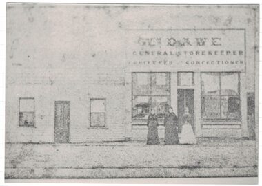
Photograph, Dawe's Store
... Dawe is shown on the Township of Linton plan as the owner of Allotment 4, Section 1A. ...Dawe is shown on the Township of Linton plan as the owner of Allotment 4, Section 1A. ...The Dawe family shop is thought to have been in Sussex Street/Skipton Road, opposite Wishart's forge. W. Dawe is shown on the Township of Linton plan as the owner of Allotment 4, Section 1A. Municipal directories show "William Dawe, Fruiterer" in the 1880s, and from the 1890s "Thomas Dawe, Fruiterer". (Thomas was William Dawe's son.) Reports in the Ballarat Star in 1875 and 1876 show that along with his son-in-law Robert Simeon Nelson, William Dawe was was a partner in the 'Bristol Reef (or Bristol Quartz) Company'. From about 1901, the Dawe shop also briefly included the undertaking business run by William Dawe's grandson, R. S. Nelson (the younger). A black and white copy of an original faded Photostat which shows three women standing in front of a building "Wm. Dawe General Storekeeper Fruiterer Confectioner".william dawe, shops, general store, sussex street, robert s. nelson (jnr) -
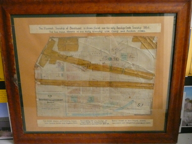 Bendigo Historical Society Inc.
Document - PLAN OF TOWNSHIP OF SANDHURST 1854, July 25. 1854
... PLAN OF TOWNSHIP OF SANDHURST 1854...Coloured- The planned township of Sandhurst is placed over the early Bendigo creek township of 1854. ...Coloured- The planned township of Sandhurst is placed over the early Bendigo creek township of 1854. ...Coloured- The planned township of Sandhurst is placed over the early Bendigo creek township of 1854. The two main streets of the early township were Camp and Auction streets. The street shown as Dowling street later became Queen & Hopetoun streets. The building near the bridge at View Point is Pykes Building. The Post Office was located here in 1854 - 58. Bernal street is now Chapel street. The creeks were straightened to their present courses. Streets on map are. Pall Mall - Bridge - McCrae - Hargraves - Lyttleton - Myers - Mollison - McLaren - Mitchell - Williamson - Mundy - Bernal - Baxter - Larritt - Bramble - McIvor - Bull. Also shown on map: Bendigo Creek - Government Reserve - Present Cemetery - Proposed diversion of creek. FH 562 Deframed 2022Lithographed at Surveyor Generals Office. Melbourne. July 25. 1854. By R. Meikle.place, bendigo, original 1854 bendigo map -
 Bendigo Historical Society Inc.
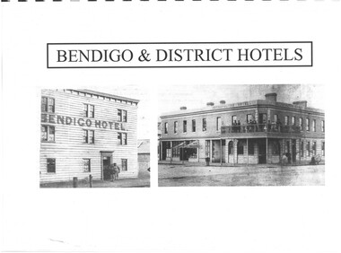
Document - INDEXES
... District statistics - Mayors and Shire Presidents, Bendigo Football League Premiers 1880- 1987, Sportstar of the year 1965-1987 Plans of townships and Parishes held at Dudley House. ...District statistics - Mayors and Shire Presidents, Bendigo Football League Premiers 1880- 1987, Sportstar of the year 1965-1987 Plans of townships and Parishes held at Dudley House. ...Indexes Includes Names from the 1856 Petition Bendigo and District Hotels Final Marunari List Terry Davidson 1871 - 2018 Index to RHSV Bendigo Branch Newsletters Nov. 1971 - July 2002 Helen Mainka 1954 Bendigo Business District Directory McConnell’s Street and general Directory Date unknown Victorian Directory 1904 Bendigo and District Directory 1904 – 1905 Bendigo district general Directory 1859 City of Bendigo Historical Information Bendigo Hotels compiled by Len Bennetts Hotels of Bendigo and District Compiled by Len Bennetts Sandhurst Land Sales 1854 – 1856 Ralph Birrell Chronicles of Bendigo from the Bendigo Advertiser Christmas Supplement December 22 1904 Some Photographers 1850 – 1900. Including some Bendigo Photographers 1854 – 1958 St. Patrick’s Annual Sports advertisers. Date Unknown Fatalities listed in Bendigo Advertiser 1888-1935. Two copies One by year. One alphabetical. District statistics - Mayors and Shire Presidents, Bendigo Football League Premiers 1880- 1987, Sportstar of the year 1965-1987 Plans of townships and Parishes held at Dudley House. From the Bendigo Lands Office 1976.index, directory -
 Warrnambool and District Historical Society Inc.
Book, Description & plans of title & grants
... township of Warrnambool while others relate to areas such as Nullawarre, Purnim and Framlingham. These documents come under the Transfer of lands act of 1890. The significance of this book lies in the many names and the land to which they were connected. warrnambool warrnambool history certificate of title crown grant warrnambool Deep maroon paper over card cover with dark green fabric binding.Alphabetical index at the front followed by 200 pages which record details of the Certificates of title and Crown Grants from around the period of Description & plans of title & grants Book ...This book contains certificates of title and Crown grants which record local changes of ownership.many are in the township of Warrnambool while others relate to areas such as Nullawarre, Purnim and Framlingham. These documents come under the Transfer of lands act of 1890.The significance of this book lies in the many names and the land to which they were connected. Deep maroon paper over card cover with dark green fabric binding.Alphabetical index at the front followed by 200 pages which record details of the Certificates of title and Crown Grants from around the period of warrnambool, warrnambool history, certificate of title, crown grant warrnambool -
Warrnambool and District Historical Society Inc.
Document (item) - Allansford land purchase document, Land purchase document, 1864
... Lot no. 11 as marked and described on the Plan of Subdivision of the Township of Allansford. For which I have received the um of five pounds Stg. being the purchase money of same. ...township of Allansford in the mid 1850s by sub-dividing the land he owned there. John Allan moved to the Gippsland area late in 1864. This piece of paper is most significant as it is an original record of an early transaction in the history of Allansford, a town now part of Warrnambool City. Allansford History John Allan Isabella McQueen Mrs isabella McQueen Bot. of Robert Gregory As agent for J M Allan Esq. Lot no. 11 as marked and described on the Plan ...This paper contains details of the purchase of Lot 11 in the Township of Allansford in 1864. The purchaser, Isabella McQueen, was born in Scotland in 1814, married Alexander McQueen in 1850 and with her family migrated to Australia in 1854. After her husband's death in 1860 Isabella purchased the land in Frank Street, Allansford in 1864 and lived in a house there with family members until her death in 1895. She had purchased the land, via an agent, from John Allan who with his brothers were the pioneer European settlers in the Allansford area. John Allan had created the township of Allansford in the mid 1850s by sub-dividing the land he owned there. John Allan moved to the Gippsland area late in 1864. This piece of paper is most significant as it is an original record of an early transaction in the history of Allansford, a town now part of Warrnambool City.Mrs isabella McQueen Bot. of Robert Gregory As agent for J M Allan Esq. Lot no. 11 as marked and described on the Plan of Subdivision of the Township of Allansford. For which I have received the um of five pounds Stg. being the purchase money of same. Robert Gregory 21st October 1864allansford history, john allan, isabella mcqueen -
 Kiewa Valley Historical Society
Folder - Early Photos of Mt Beauty
... township. Also included are: 1. 3 foolscap pages -Nov., 1953 Kiewa Hydro-Electric Scheme Progress. 2. SECV Drawing Plan...township. Also included are: 1. 3 foolscap pages -Nov., 1953 Kiewa Hydro-Electric Scheme Progress. 2. SECV Drawing Plan ...Mt Beauty township was built during the 1950's to house the employees of the State Electricity Commission working on the Kiewa Hydro Electric Scheme. After the completion of the Kiewa Hydro Electric Scheme many houses were sold and the public buildings handed over to the Alpine Shire. Mt Beauty has always been a tourist destination especially with its proximity to the ski fields at Falls Creek.This folder contains many early photos of Mt Beauty showing the construction town during its development during the Kiewa Hydro Electric Scheme and its early days of tourism. A3 size black plastic folder with clear plastic sleeves holding early black & white photos of Mt Beauty township. Also included are: 1. 3 foolscap pages -Nov., 1953 Kiewa Hydro-Electric Scheme Progress. 2. SECV Drawing Plan (No. K6242) of Mt Beauty House - 3 angles and floor plan, English Pre-cut Type 3B.ILA with note that all houses with prefix 3B are similar. 3. Orange, black and white pamphlet "Welcome to Kiewa" 4. Tourist postcard 'fold-up' of 11 postcards "Mt Beauty and the Kiewa Scheme, Victoria 5. Drawing Plan of 'Mt Beauty Housing. Use of Prefabricated Cubicles for Houses. Type C.1 6. Drawing Plan of 'Kiewa Scheme Mt Beauty Housing Type "G". 7. 5 pages on "Twelve Tips on Caring for Old Buildings 8. Booklet advertising Mt Beauty housing for sale including activities available in the area. (1960's) 9. List of Photos from SECV held by KVHS Some photos have handwritten labels mt beauty. secv. kiewa hydro electric scheme.tourism. housing. construction town. falls creek. -
 Kiewa Valley Historical Society
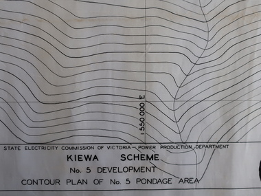
Plans - Kiewa Works Area and Environs
... Kiewa Scheme No 5 Development Contour Plan of No 5 Pondage Area 2. Mt Beauty Township 3. Kiewa Scheme No 1 Development - McKay Creek Area, Construction Layout 4. ...Kiewa Scheme No 5 Development Contour Plan of No 5 Pondage Area 2. Mt Beauty Township 3. Kiewa Scheme No 1 Development - McKay Creek Area, Construction Layout 4. ...State Electricity Commission of Victoria constructed the Kiewa Hydro Electric Scheme from the late 1940s to 1961. These plans were used during the construction.Plans and Maps were used during the construction of the Kiewa Hydro Electric SchemeTransparent with blue tinge plans/maps created by the SECV during the construction of the Kiewa Hydro Electric Scheme. 1. Kiewa Scheme No 5 Development Contour Plan of No 5 Pondage Area 2. Mt Beauty Township 3. Kiewa Scheme No 1 Development - McKay Creek Area, Construction Layout 4. Kiewa Works and Environs 5. North Eastern Victoria and Adjoining Snowy Mountains Regionsecv, kiewa hydro electric scheme plans -
 Kiewa Valley Historical Society
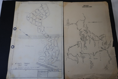
Maps - Bogong High Plains & Mt Beauty Township
... Mt Beauty Street Plan by SECV with Section Nos. and house numbers Maps - Bogong High Plains & Mt Beauty Township ...The SECV continually updated their mapsDuring the development of the KHES the SECV had to continually update their mapsBoth Foolscap 1. Titled: High Plains Access Tracks & Roads 2. Mt Beauty Street Plan by SECV with Section Nos. and house numbersBoth have sticky tape marks on their back.khes maps -
 Kiewa Valley Historical Society
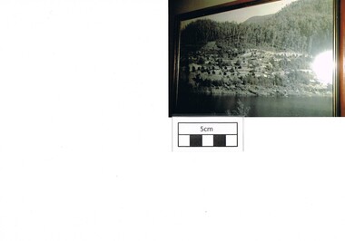
Photograph Bogong, Bogong Township Circa 1950, circa 1940s to 1950s
... This was the beginning of a planned and controlled form of sustainable tourist orientated development of the Victorian Alps and high plains region. The Bogong Township ...The Bogong Village was originally constructed (1937-1940) by the State Electricity Commission to house, engineers and construction workers working on the Kiewa Hydroelectric Scheme. These workers were initially settled in 26 houses and were mainly of European heritage. At the completion of the scheme, in the 1960's, the village was opened to public/tourism use. This photograph shows the village before beautification for tourism was introduced and "bare bones" homes and village usage existed.This photo clearly presents a period of restricted human occupation of a very fragile Alpine environment(up to 4000 workmen involved). This was the beginning of a planned and controlled form of sustainable tourist orientated development of the Victorian Alps and high plains region. The Bogong Township was the base camp for workers employed by the State Electricity Commission. After the construction phase was completed, the planning and controls originating from this period have been modified to allow a greater public access of this unique environment.Photograph of a framed glass enclosed black and white photograph of the Bogong settlement Paper details "KodakXtraLife paper" on back of photo. bogong village, bogong township, sec alpine constructions, hydro, kiewa scheme -
 Emerald Museum & Nobelius Heritage Park
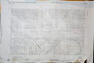
Map - Melbourne & Metropolitan Board of Works, Emerald Victoria, Topographical Map - Amendment 16.1.89, Melbourne and Metropolitan Board of Works, MMBW Topographical Map -Yarra 2500/28.01, 1989
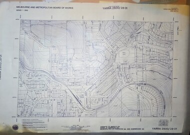
... Mitchell, Chief Surveyor, Engineering Branch: May 1984/Survey Co-ordination Act plan classification BB2/Revised and re-issued/Latest cadastral amendment 16.1.89/Scale 1:2500/Township of Emerald 5280, Parish of Gembrook 2645, Municipalities of Pakenham 262 And Sherbrooke259/YARRA 2500/28.01 ...Emerald Museum & Nobelius Heritage Park 5 Crichton Rd Emerald yarra-valley-and-the-dandenong-ranges Emerald Topographical map of Emerald township from 1989, based on photography from 1981 Lodged plans marked * have easements omitted/Lot boundaries are based on occupation and are not necessarily title/The grid lines on this sheet represent the A.M.G. plan boundaries for the 1:500 series. ...Topographical map of Emerald township from 1989, based on photography from 1981Image of printed Melbourne & Metropolitan Board of Works topographical map - Emerald - Yarra 2500/28.01non-fictionTopographical map of Emerald township from 1989, based on photography from 1981emerald -
 Emerald Museum & Nobelius Heritage Park
Map - Transparency edition - Melbourne & Metropolitan Board of Works, Emerald Victoria, Topographical Map - Amendment 16.1.89, Melbourne and Metropolitan Board of Works, MMBW Topographical Map -Yarra 2500/28.01, 1989
... Mitchell, Chief Surveyor, Engineering Branch: May 1984/Survey Co-ordination Act plan classification BB2/Revised and re-issued/Latest cadastral amendment 16.1.89/Scale 1:2500/Township of Emerald 5280, Parish of Gembrook 2645, Municipalities of Pakenham 262 And Sherbrooke259/YARRA 2500/28.01 ...Emerald Museum & Nobelius Heritage Park 5 Crichton Rd Emerald yarra-valley-and-the-dandenong-ranges Emerald Topographical map of Emerald township from 1988 Lodged plans marked * have easements omitted/Lot boundaries are based on occupation and are not necessarily title/The grid lines on this sheet represent the A.M.G. plan boundaries for the 1:500 series. ...Topographical map of Emerald township from 1988Image of printed Melbourne & Metropolitan Board of Works topographical map - Emerald - Yarra 2500/28.01non-fictionTopographical map of Emerald township from 1988emerald -
 Emerald Museum & Nobelius Heritage Park
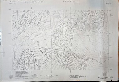
Map - Melbourne & Metropolitan Board of Works, Emerald Victoria, Topographical Map - Amendment 5.1.88, Melbourne and Metropolitan Board of Works, MMBW Topographical Map -Yarra 2500/29.01, 1988
... Emerald Museum & Nobelius Heritage Park 5 Crichton Rd Emerald yarra-valley-and-the-dandenong-ranges Emerald Topographical map of Emerald township from 1989, based on photography from 1981 Lodged plans marked * have easements omitted/Lot boundaries are based on occupation and are not necessarily title/The grid lines on this sheet represent the A.M.G. plan boundaries for the 1:500 series. ...Topographical map of Emerald township from 1989, based on photography from 1981Image of printed Melbourne & Metropolitan Board of Works topographical map - Emerald - Yarra 2500/29.01non-fictionTopographical map of Emerald township from 1989, based on photography from 1981emerald -
 Emerald Museum & Nobelius Heritage Park
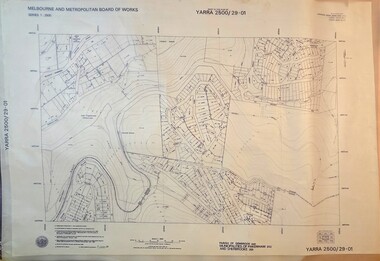
Map - Transparency of Melbourne & Metropolitan Board of Works, Emerald Victoria, Topographical Map - Amendment 5.1.88, Melbourne and Metropolitan Board of Works, MMBW Topographical Map -Yarra 2500/29.01, 1988
... Emerald Museum & Nobelius Heritage Park 5 Crichton Rd Emerald yarra-valley-and-the-dandenong-ranges Emerald Topographical map of Emerald township from 1988 Lodged plans marked * have easements omitted/Lot boundaries are based on occupation and are not necessarily title/The grid lines on this sheet represent the A.M.G. plan boundaries for the 1:500 series. ...Topographical map of Emerald township from 1988Image transparency of printed Melbourne & Metropolitan Board of Works topographical map - Emerald - Yarra 2500/29.01non-fictionTopographical map of Emerald township from 1988emerald