Showing 135 items matching "water conservation"
-
 Wodonga & District Historical Society Inc
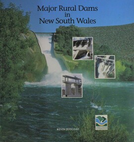
Book - Major Rural Dams In New South Wales, Department of Land and Water Conservation, NSW, 1996
... ...water conservation...Department of Land and Water Conservation, NSW...Major Rural Dams In New South Wales Book Major Rural Dams In New South Wales Department of Land and Water Conservation, NSW ...A pictorial examination of key dams established throughout New South Wales as part of approaches to water management in the state.non-fictionA pictorial examination of key dams established throughout New South Wales as part of approaches to water management in the state.dams new south wales, water management, water conservation -
 Ringwood and District Historical Society
Envelope, Packet: Water Conservation Booklet and Ringwood Clippings. Proposed Yarra Dam. 1964
... Packet: Water Conservation Booklet and Ringwood Clippings. ...Water conservation booklet - 1968; Newspaper cuttings 1964-1991...Ringwood and District Historical Society 125A Warrandyte Road Ringwood North melbourne Water conservation booklet - 1968; Newspaper cuttings 1964-1991 Packet: Water Conservation Booklet and Ringwood Clippings. ...Water conservation booklet - 1968; Newspaper cuttings 1964-1991 -
 Wodonga & District Historical Society Inc
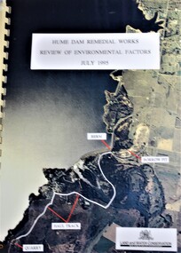
Booklet - Hume Dam Remedial Works - Review of Environmental Factors July 1995, Department of Land and Water Conservation, NSW Government, July 1995
... Department of Land and Water Conservation, NSW Government...Hume Dam Remedial Works - Review of Environmental Factors July 1995 Booklet Hume Dam Remedial Works - Review of Environmental Factors July 1995 Department of Land and Water Conservation, NSW Government ...The findings of a review into the environmental impact of remedial works being carried out on the Hume Dam.non-fictionThe findings of a review into the environmental impact of remedial works being carried out on the Hume Dam.hume dam, remedial works dams, environmental impact of dams -
 Wodonga & District Historical Society Inc
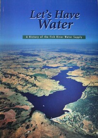
Book - Let's Have Water - A history of the Fish River Water Supply, Robin McLachlan, Denis Barrett, Jack Domis, Nick Welling, 1997
... Department of Land and Water Conservation, NSW...Let's Have Water - A history of the Fish River Water Supply Book Let's Have Water - A history of the Fish River Water Supply Robin McLachlan, Denis Barrett, Jack Domis, Nick Welling Department of Land and Water Conservation, NSW ...A history of the development of the management of the Fish River Water Supply Scheme in Central NSW. The scheme extends across the local government areas of the Shire of Oberon, the City of Lithgow and the City of the Blue Mountains.non-fictionA history of the development of the management of the Fish River Water Supply Scheme in Central NSW. The scheme extends across the local government areas of the Shire of Oberon, the City of Lithgow and the City of the Blue Mountains.water nsw, fish river region nsw, oberon dam, water resources development nsw australia -
 The Beechworth Burke Museum
Photograph
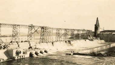
... Department of Land & Water Conservation...Archaeological surveys were completed by Austral Archaeology, which was done when the Department of Land & Water Conservation was doing work to improve Hume Dam. ...Archaeological surveys were completed by Austral Archaeology, which was done when the Department of Land & Water Conservation was doing work to improve Hume Dam. ...Taken on 25 October 1930, various houses with the Hume Dam under construction are depicted in the background. The construction of the Hume Dam took place from 1919 to 1936. At the time of construction, it was the second largest dam in the world. It was also one of the earliest civil projects developed after the Federation. Some of the Dam workers consisted of World War I veterans. Dam workers often settled their families in Mitta Junction Village and Wodonga. Archaeological surveys were completed by Austral Archaeology, which was done when the Department of Land & Water Conservation was doing work to improve Hume Dam. The archaeological report that came out of the survey recommended three sites of interest where archaeological excavation should be done: Camp Ganger’s Quarters, Stableman’s Quarters, and the Industrial Dump. The excavation uncovered artefacts. Mitta Mitta: Mitta Mitta is situated between Mount Welcome and Mount Misery. It is named after the river that explorers Hume and Hovell discovered in 1824. The town would eventually become a huge gold mining town. Mitta Mitta is called Midamodunga by the local Indigenous peoples Wodonga: Wodonga is situated on the Murray River and is part of North East Victoria. Hume and Hovell: Hamilton Hume (1979-1873) and William Hilton Hovell (1786-1875). W. H. Hovell was born in Norfolk England and Hume was born in Parramatta, New South Wales Hovell and Hume undertook an exploration journey in 1824 and thought they discovered a river, which turned out to be the Murray River. They returned home in 1825, but returned to the area in 1826 and discovered coal in the area. This photo is historically significant as it shows the Hume Dam under construction in 1930. The Dam was named after Hamilton Hume, who is an important historical figure for this area as he helped discover the area where resources were found.Sepia rectangular photograph printed unmountedReverse: 84-19-5 / 1997.3185/ Values & spillway. / When completed the wall / will be as high as the / scaffolding. [featuring trademark: kodak print]construction, houses, veterans, mitta junction village, hume dam, world war i, federation, wodonga, archaeological survey, excavation, austral archaeology, department of land & water conservation, camp ganger's quarter's, stableman's quarters, industrial dump, artefacts, mitta mitta, mount welcome, mount misery, murray river, hamilton hume, william hilton hovell, hume and hovell expedition -
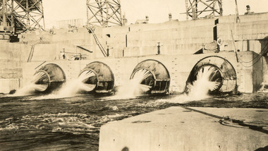 The Beechworth Burke Museum
Photograph, c1930
... Department of Land & Water Conservation...Archaeological surveys were completed by Austral Archaeology, which was done when the Department of Land & Water Conservation was doing work to improve Hume Dam. ...Archaeological surveys were completed by Austral Archaeology, which was done when the Department of Land & Water Conservation was doing work to improve Hume Dam. ...Taken on 25 October 1930, various houses with the Hume Dam under construction are depicted in the background. The construction of the Hume Dam took place from 1919 to 1936. At the time of construction, it was the second largest dam in the world. It was also one of the earliest civil projects developed after the Federation. Some of the Dam workers consisted of World War I veterans. Dam workers often settled their families in Mitta Junction Village and Wodonga. Archaeological surveys were completed by Austral Archaeology, which was done when the Department of Land & Water Conservation was doing work to improve Hume Dam. The archaeological report that came out of the survey recommended three sites of interest where archaeological excavation should be done: Camp Ganger’s Quarters, Stableman’s Quarters, and the Industrial Dump. The excavation uncovered artefacts. Mitta Mitta: Mitta Mitta is situated between Mount Welcome and Mount Misery. It is named after the river that explorers Hume and Hovell discovered in 1824. The town would eventually become a huge gold mining town. Mitta Mitta is called Midamodunga by the local Indigenous peoples Wodonga: Wodonga is situated on the Murray River and is part of North East Victoria. Hume and Hovell: Hamilton Hume (1979-1873) and William Hilton Hovell (1786-1875). W. H. Hovell was born in Norfolk England and Hume was born in Parramatta, New South Wales Hovell and Hume undertook an exploration journey in 1824 and thought they discovered a river, which turned out to be the Murray River. They returned home in 1825, but returned to the area in 1826 and discovered coal in the area.This photo is historically significant as it shows the Hume Dam under construction in 1930. The Dam was named after Hamilton Hume, who is an important historical figure for this area as he helped discover the area where resources were found.Sepia rectangular photograph printed unmountedReverse: 84-19-2/ 1997.3188/ These are the four / release valves they are / not always open (illegible) this / when closed the water flows / over the spillway. [featuring trademark: kodak print] photograph number: 354construction, houses, veterans, mitta junction village, hume dam, world war i, federation, wodonga, archaeological survey, excavation, austral archaeology, department of land & water conservation, camp ganger's quarter's, stableman's quarters, industrial dump, artefacts, mitta mitta, mount welcome, mount misery, murray river, hamilton hume, william hilton hovell, hume and hovell expedition -
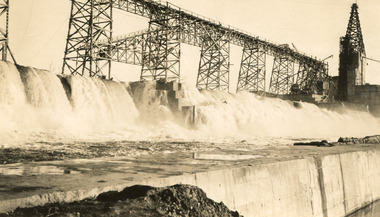 The Beechworth Burke Museum
Photograph, 25 October 1930
... Department of Land & Water Conservation...Archaeological surveys were completed by Austral Archaeology, which was done when the Department of Land & Water Conservation was doing work to improve Hume Dam. ...Archaeological surveys were completed by Austral Archaeology, which was done when the Department of Land & Water Conservation was doing work to improve Hume Dam. ...Taken on 25 October 1930, various houses with the Hume Dam under construction are depicted in the background. The construction of the Hume Dam took place from 1919 to 1936. At the time of construction, it was the second largest dam in the world. It was also one of the earliest civil projects developed after the Federation. Some of the Dam workers consisted of World War I veterans. Dam workers often settled their families in Mitta Junction Village and Wodonga. Archaeological surveys were completed by Austral Archaeology, which was done when the Department of Land & Water Conservation was doing work to improve Hume Dam. The archaeological report that came out of the survey recommended three sites of interest where archaeological excavation should be done: Camp Ganger’s Quarters, Stableman’s Quarters, and the Industrial Dump. The excavation uncovered artefacts. Mitta Mitta: Mitta Mitta is situated between Mount Welcome and Mount Misery. It is named after the river that explorers Hume and Hovell discovered in 1824. The town would eventually become a huge gold mining town. Mitta Mitta is called Midamodunga by the local Indigenous peoples Wodonga: Wodonga is situated on the Murray River and is part of North East Victoria. Hume and Hovell: Hamilton Hume (1979-1873) and William Hilton Hovell (1786-1875). W. H. Hovell was born in Norfolk England and Hume was born in Parramatta, New South Wales Hovell and Hume undertook an exploration journey in 1824 and thought they discovered a river, which turned out to be the Murray River. They returned home in 1825, but returned to the area in 1826 and discovered coal in the area.This photo is historically significant as it shows the Hume Dam under construction in 1930. The Dam was named after Hamilton Hume, who is an important historical figure for this area as he helped discover the area where resources were found.Sepia rectangular photograph printed unmountedReverse: 84-19-6/ 1997.3187/ The spillway [featuring trademark: kodak print] construction, houses, veterans, mitta junction village, hume dam, world war i, federation, wodonga, archaeological survey, excavation, austral archaeology, department of land & water conservation, camp ganger's quarter's, stableman's quarters, industrial dump, artefacts, mitta mitta, mount welcome, mount misery, murray river, hamilton hume, william hilton hovell, hume and hovell expedition -
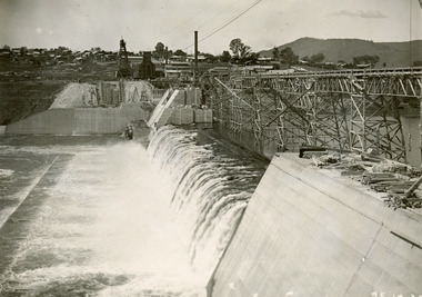 The Beechworth Burke Museum
Photograph, 25 October 1930
... Department of Land & Water Conservation...Archaeological surveys were completed by Austral Archaeology, which was done when the Department of Land & Water Conservation was doing work to improve Hume Dam. ...Archaeological surveys were completed by Austral Archaeology, which was done when the Department of Land & Water Conservation was doing work to improve Hume Dam. ...Taken on 25 October 1930, various houses with the Hume Dam under construction are depicted in the background. The construction of the Hume Dam took place from 1919 to 1936. At the time of construction, it was the second largest dam in the world. It was also one of the earliest civil projects developed after the Federation. Some of the Dam workers consisted of World War I veterans. Dam workers often settled their families in Mitta Junction Village and Wodonga. Archaeological surveys were completed by Austral Archaeology, which was done when the Department of Land & Water Conservation was doing work to improve Hume Dam. The archaeological report that came out of the survey recommended three sites of interest where archaeological excavation should be done: Camp Ganger’s Quarters, Stableman’s Quarters, and the Industrial Dump. The excavation uncovered artefacts. Mitta Mitta: Mitta Mitta is situated between Mount Welcome and Mount Misery. It is named after the river that explorers Hume and Hovell discovered in 1824. The town would eventually become a huge gold mining town. Mitta Mitta is called Midamodunga by the local Indigenous peoples Wodonga: Wodonga is situated on the Murray River and is part of North East Victoria. Hume and Hovell: Hamilton Hume (1979-1873) and William Hilton Hovell (1786-1875). W. H. Hovell was born in Norfolk England and Hume was born in Parramatta, New South Wales Hovell and Hume undertook an exploration journey in 1824 and thought they discovered a river, which turned out to be the Murray River. They returned home in 1825, but returned to the area in 1826 and discovered coal in the area.This photo is historically significant as it shows the Hume Dam under construction in 1930. The Dam was named after Hamilton Hume, who is an important historical figure for this area as he helped discover the area where resources were found.Black and white rectangular photograph printer unmountedReverse: 84-20-1/ 1997.3147construction, houses, veterans, mitta junction village, hume dam, world war i, federation, wodonga, archaeological survey, excavation, austral archaeology, department of land & water conservation, camp ganger's quarter's, stableman's quarters, industrial dump, artefacts, mitta mitta, mount welcome, mount misery, murray river, hamilton hume, william hilton hovell, hume and hovell expedition -
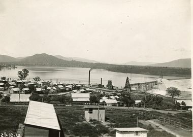 The Beechworth Burke Museum
Photograph, 25 October 1930
... Department of Land & Water Conservation...Archaeological surveys were completed by Austral Archaeology, which was done when the Department of Land & Water Conservation was doing work to improve Hume Dam. ...Archaeological surveys were completed by Austral Archaeology, which was done when the Department of Land & Water Conservation was doing work to improve Hume Dam. ...Taken on 25 October 1930, various houses with the Hume Dam under construction are depicted in the background. The construction of the Hume Dam took place from 1919 to 1936. At the time of construction, it was the second largest dam in the world. It was also one of the earliest civil projects developed after the Federation. Some of the Dam workers consisted of World War I veterans. Dam workers often settled their families in Mitta Junction Village and Wodonga. Archaeological surveys were completed by Austral Archaeology, which was done when the Department of Land & Water Conservation was doing work to improve Hume Dam. The archaeological report that came out of the survey recommended three sites of interest where archaeological excavation should be done: Camp Ganger’s Quarters, Stableman’s Quarters, and the Industrial Dump. The excavation uncovered artefacts. Mitta Mitta: Mitta Mitta is situated between Mount Welcome and Mount Misery. It is named after the river that explorers Hume and Hovell discovered in 1824. The town would eventually become a huge gold mining town. Mitta Mitta is called Midamodunga by the local Indigenous peoples Wodonga: Wodonga is situated on the Murray River and is part of North East Victoria. Hume and Hovell: Hamilton Hume (1979-1873) and William Hilton Hovell (1786-1875). W. H. Hovell was born in Norfolk England and Hume was born in Parramatta, New South Wales Hovell and Hume undertook an exploration journey in 1824 and thought they discovered a river, which turned out to be the Murray River. They returned home in 1825, but returned to the area in 1826 and discovered coal in the area. This photo is historically significant as it shows the Hume Dam under construction in 1930. The Dam was named after Hamilton Hume, who is an important historical figure for this area as he helped discover the area where resources were found. Black and white rectangular photograph printer unmountedReverse: 1997.3145/ 84-20-2construction, houses, veterans, mitta junction village, hume dam, world war i, federation, wodonga, archaeological survey, excavation, austral archaeology, department of land & water conservation, camp ganger's quarter's, stableman's quarters, industrial dump, artefacts, mitta mitta, mount welcome, mount misery, murray river, hamilton hume, william hilton hovell, hume and hovell expedition -
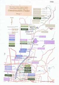 Greensborough Historical Society
Maps, Yan Yean Water Supply System Conservation Management Plan: Construction dates Map 1, 2007_
... Yan Yean Water Supply System Conservation Management Plan: Construction dates Map 1...Greensborough Historical Society 34A Glenauburn Road Lower Plenty Lower Plenty melbourne Plan of Yan Yean Water Supply System, showing natural and constructed features from 1850s to 1930s from Silver Creek Weirs to Eastern Freeway. water supply yan yean reservoir plenty river Printed in colour one side. 3 copies Yan Yean Water Supply System Conservation Management Plan: Construction dates Map 1 Maps Spatial Vision ...Plan of Yan Yean Water Supply System, showing natural and constructed features from 1850s to 1930s from Silver Creek Weirs to Eastern Freeway.Printed in colour one side. 3 copieswater supply, yan yean reservoir, plenty river -
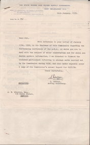 Bendigo Historical Society Inc.
Document - EDWIN BUCKLAND COLLECTION: THE STATE RIVERS AND WATER SUPPLY COMMISSION, 1939
... Ref. letter Janusary 17th 1939 to Chairman of A.N.A. and Water Conservation....Ref. letter Janusary 17th 1939 to Chairman of A.N.A. and Water Conservation. Document EDWIN BUCKLAND COLLECTION: THE STATE RIVERS AND WATER SUPPLY COMMISSION. ...Dolcument. The State Rivers and Water Commission. Ref. letter Janusary 17th 1939 to Chairman of A.N.A. and Water Conservation. -
Glen Eira Historical Society
Article - Glen Eira Parks and Gardens
... ... Water Conservation...Glen Eira Historical Society 965 Glen Huntly Rd Caulfield VIC 3162 melbourne This file contains four items. 1/ An article in the Glen Eira News reporting on a new park with indigenous planting and an interpretive walk being developed to link Duncan McKinnon Reserve and Packer Park in Murrumbeena, dated September 2000. 2/ An article from the Glen Eira Leader on the converting of sports grounds from cool season to warm season grasses, as well as the installation of subsurface drip irrigation at Princes Park, Caulfield South, dated March 2012. 3/ An article from the Caulfield/Port Phillip leader reporting Caulfield RSL military historian Carl Johnson’s appeal to have a “lone pine” in Caulfield Park designated as a war memorial, dated 11/9/2012 4/ An article from the Glen Eira/Port Phillip Leader reporting on the Friends of Caulfield Park organising the first band stand concert in over twenty years with the City of Glen Eira Band, dated 6/11/2012 Glen Eira Council Hawthorn Rd Caulfield Glen Eira Rd Caulfield Glen Eira Caulfield Parks Reserves Leila Rd Caulfield Glen Eira City Council Landscaping Memorial Park Kooyong Rd Caulfield North Caulfield Recreation Tennis Club Murrumbeena Rd Caulfield Churchill Green housing estate North Rd Caulfield Boake Street Caulfield Exservices organisation RSL Clubs Sporting Clubs Recreations Sportsgrounds Clubs Tennis Clubs Associations Leisure Cultural Events Cultural Activities Sports Establishments Recreations Establishments Irrigation Water Conservation Conservation of Natural Resources Water Supply Ovals Playing fields Tennis Courts Murrumbeena Park School Concerts Musical Activities Musical Events Glen Eira Artists society DiMarco Lisa St. ...This file contains four items. 1/ An article in the Glen Eira News reporting on a new park with indigenous planting and an interpretive walk being developed to link Duncan McKinnon Reserve and Packer Park in Murrumbeena, dated September 2000. 2/ An article from the Glen Eira Leader on the converting of sports grounds from cool season to warm season grasses, as well as the installation of subsurface drip irrigation at Princes Park, Caulfield South, dated March 2012. 3/ An article from the Caulfield/Port Phillip leader reporting Caulfield RSL military historian Carl Johnson’s appeal to have a “lone pine” in Caulfield Park designated as a war memorial, dated 11/9/2012 4/ An article from the Glen Eira/Port Phillip Leader reporting on the Friends of Caulfield Park organising the first band stand concert in over twenty years with the City of Glen Eira Band, dated 6/11/2012glen eira council, hawthorn rd caulfield, glen eira rd caulfield, glen eira, caulfield, parks, reserves, leila rd caulfield, glen eira city council, landscaping, memorial park, kooyong rd caulfield north, caulfield recreation tennis club, murrumbeena rd caulfield, churchill green housing estate, north rd caulfield, boake street caulfield, exservices organisation, rsl clubs, sporting clubs, recreations, sportsgrounds, clubs, tennis clubs, associations, leisure, cultural events, cultural activities, sports establishments, recreations establishments, irrigation, water conservation, conservation of natural resources, water supply, ovals, playing fields, tennis courts, murrumbeena park, school concerts, musical activities, musical events, glen eira artists society, dimarco lisa, st. aloysius college, band rotundas, entertainment structures, musical ensembles, city of glen eira band, bands, the friends of caulfield park, gallipoli lone pine, princes park, packer park, duncan mckinnon reserve, king george reserve, caulfield park, glenhuntly park, glen huntly park, bentleigh reserve, victory park, schools, education establishments, recycling, water disposal, cultural structures, cultural establishments, caulfield rsl, johnson carl, war memorials, monuments, memorials, avenue of honour, “lone pine”, glen eira leader, glen eira news, caulfield/port phillip leader, glen eira leader -
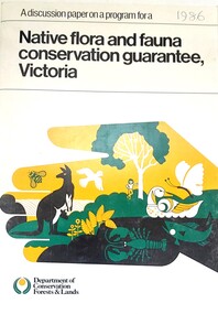 Wodonga & District Historical Society Inc
Book - Discussion Paper on Native flora and fauna conservation guarantee, Victoria, Department of Conservation, Forests and Lands, Victoria, 1986
... ...Water Conservation...Land Management Conservation Victoria Water Conservation This publication was produce as a discussion paper to inform decisions related to changes in land management and conservation regulations and policy in 1986 On bottom of front - Logo Department of Conservation, Forests and Lands An A4 size document outlining findings into an investigation into the state of flora and fauna in Victoria. ...This publication was produce as a discussion paper to inform decisions related to changes in land management and conservation regulations and policy in 1986An A4 size document outlining findings into an investigation into the state of flora and fauna in Victoria.This publication was produce as a discussion paper to inform decisions related to changes in land management and conservation regulations and policy in 1986land management, conservation victoria, water conservation -
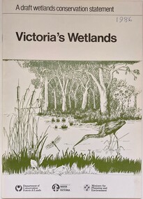 Wodonga & District Historical Society Inc
Book - Victoria's Wetlands, Dept. of Conservation, Forests & Lands, 1986
... ...Water Conservation... On foot of cover: Department of Conservation, Forests & Lands, Department of Water Resources, Victoria, Ministry for Planning and Environment...Wodonga & District Historical Society Inc Hut 97, Bonegilla Migrant Experience, 132 Bonegilla Road Bonegilla the-murray Wetland protection Wetlands Victoria Water Conservation This publication was the result of an inquiry into the state of wetland environments in Victoria. ...This publication was the result of an inquiry into the state of wetland environments in Victoria. It produced a draft strategy for conservation of threatened areas in the future.An 22 page book containing maps and illustrationsThis publication was the result of an inquiry into the state of wetland environments in Victoria. It produced a draft strategy for conservation of threatened areas in the future.wetland protection, wetlands victoria, water conservation -
Whitehorse Historical Society Inc.
Article, All in a good day's work, 2008
... ...Water conservation...Whitehorse Historical Society Inc. 2-10 Deep Creek Road Mitcham melbourne Day Steven City of Whitehorse Parkswide Water conservation Plant nurseries Article on Steve Day's water recycling program for Whitehorse Council nurseries. ...Article on Steve Day's water recycling program for Whitehorse Council nurseries.Article on Steve Day's water recycling program for Whitehorse Council nurseries.Article on Steve Day's water recycling program for Whitehorse Council nurseries.day, steven, city of whitehorse parkswide, water conservation, plant nurseries -
Whitehorse Historical Society Inc.
Document, Whitehorse ecovision, 1/09/2002 12:00:00 AM
... ...Water conservation...City of Whitehorse Water conservation Wildlife conservation Conservation of natural resources Pollution Whitehorse Council report - a strategy for ecological sustainability. ...Whitehorse Council report - a strategy for ecological sustainability.Whitehorse Council report - a strategy for ecological sustainability. Includes basic statistics, information and detailed proposals for sustainable use of energy, water. Protection of biodiversity, Transport, Effects on the community.Whitehorse Council report - a strategy for ecological sustainability. city of whitehorse, water conservation, wildlife conservation, conservation of natural resources, pollution -
 Federation University Historical Collection
Booklet, University of Ballarat Centre for Environmental Management, 1996
... soil and water assessment...conservation...The University will be working with the lessees to develop the historic Telegraph Station as a dual purpose facility for interpretation and research." university of ballarat centre for environmental management martin westbrooke richard mcewan mal weston john miller nanya telegraph station, cape otway cape otway lighthouse station cape otway telegraph station field resaerch stations s. hadden peter dahlhaus r.j. macewan pat prevett native vegetation assessment fauna management pest plants and animal research soil and water assessment conservation reserve management paul ryan richard macewan Black and white cover with clear plastic sheet. ...The Centre for Environmental Management as established in July 1995 as a strategic development initiative to consolidate the University's position as a centre for industry linked environmenttal teaching, resarech and consultancy. Page 19 "SPECIAL INITIATIVES Establishment of field Research Stations Two areas of concentration of research effort for the Centre are the Otways in the south western Victoria and the Scotia Country in the rangelands of NSW. In both these areas it is essential that ther be a secure accomodation abase for research students. In the former case there is a need for a sheltered base to enable year round field work in cold wet conditions and in the latter a base with a reliable water supply and the facilities to allow field work in very hot dry conditions which prevail from much of the year. It has been an ibjective of the Centre to establish field stations at these two sites and considerable progress has been made through the year. (i) Nanya Field Station in the Scotial Country Through the generosity of the owner, Mr Rob Taylor, an unused homestead on Nanya Station was made available to the Centre. Largely through voluntary labour during research field trips during the year this previously derelict homestead has been restored to functionality and now has facilities for up to 20 research workers with a reliable water supply, cooking, washing, and refrigeration facilities. (ii) Cape Otway Resaerch Centre Negotiations have continued through the year with the potential lessees of the Cape Otway Lighthouse Precinct with the support of the Vice Chancellor and other potential user groups within the University these have reached a successful outcome. The University will be working with the lessees to develop the historic Telegraph Station as a dual purpose facility for interpretation and research." Black and white cover with clear plastic sheet. university of ballarat, centre for environmental management, martin westbrooke, richard mcewan, mal weston, john miller, nanya, telegraph station, cape otway, cape otway lighthouse station, cape otway telegraph station, field resaerch stations, s. hadden, peter dahlhaus, r.j. macewan, pat prevett, native vegetation assessment, fauna management, pest plants and animal research, soil and water assessment, conservation reserve management, paul ryan, richard macewan -
 Orbost & District Historical Society
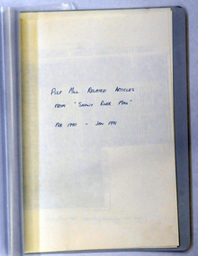
document, PULP MILL RELATED ARTICLES from "Snowy River Mail" Feb 1990 -Jan 1991, 1990 / 1991
... This folder of articles was compiled by the Department of Land & Water Conservation / Forestry....Orbost & District Historical Society Ruskin Street Orbost gippsland This folder of articles was compiled by the Department of Land & Water Conservation / Forestry. This item is a useful reference tool on the pulp /paper mill proposed for East Gippsland. pulp-mill-Orbost A small 8 pp folder of photocopied articles from the Snowy River Mail. ...This folder of articles was compiled by the Department of Land & Water Conservation / Forestry.This item is a useful reference tool on the pulp /paper mill proposed for East Gippsland.A small 8 pp folder of photocopied articles from the Snowy River Mail. They relate to the pulp/paper mill proposal in East Gippsland. pulp-mill-orbost -
Tatura Irrigation & Wartime Camps Museum
Book, Northern Irrigation District Advisory Boards, 1946
... information on water conservation, allocation of water, irrigation advice etc....Tatura Irrigation & Wartime Camps Museum 49 Hogan Street Tatura the-murray Programme of converence, Bendigo 1st and 2nd August, 1945. information on water conservation, allocation of water, irrigation advice etc. water resources books history local Small booklet of programme of irrigation converence, Bendigo 1st and 2nd August, 1945 Northern Irrigation District Advisory Boards Book ...Programme of converence, Bendigo 1st and 2nd August, 1945. information on water conservation, allocation of water, irrigation advice etc.Small booklet of programme of irrigation converence, Bendigo 1st and 2nd August, 1945water resources, books, history, local -
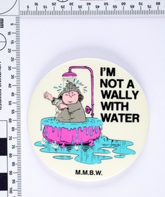 Melbourne Water
I'm not a Wally with Water badge, 1980s
... Following the 1983 Victorian drought The Board of Works (MMBW) ran a television, radio and print campaign to encourage water conservation called ‘Don’t Be a Wally with Water’. ...Melbourne Water 990 La Trobe Street Docklands melbourne Following the 1983 Victorian drought The Board of Works (MMBW) ran a television, radio and print campaign to encourage water conservation called ‘Don’t Be a Wally with Water’. ...Following the 1983 Victorian drought The Board of Works (MMBW) ran a television, radio and print campaign to encourage water conservation called ‘Don’t Be a Wally with Water’. The campaign followed Wally, a bumbling, habitual water waster, and is an early example of educating the public on water sustainability both environmentally and financially. Wally was both a cartoon character and played on television by the comedian Peter Moon. The campaign ran for several years and was designed to change attitudes towards water wastage. This MMBW branded item is associated with ‘Don’t Be a Wally with Water’ campaign, and demonstrates an early water sustainability education program. These badges would have been given out as promotional merchandise and at public events. Round metal badge with printed cartoon image and text. -
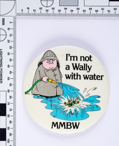 Melbourne Water
I'm not a Wally with Water badge, 1980s
... Following the 1983 Victorian drought The Board of Works (MMBW) ran a television, radio and print campaign to encourage water conservation called "Don't Be a Wally with Water". ...Melbourne Water 990 La Trobe Street Docklands melbourne Following the 1983 Victorian drought The Board of Works (MMBW) ran a television, radio and print campaign to encourage water conservation called "Don't Be a Wally with Water". ...Following the 1983 Victorian drought The Board of Works (MMBW) ran a television, radio and print campaign to encourage water conservation called "Don't Be a Wally with Water". The campaign followed Wally, a bumbling, habitual water waster, and is an early example of educating the public on water sustainability both environmentally and financially. Wally was both a cartoon character and played on television by the comedian Peter Moon. The campaign ran for several years and was designed to change attitudes towards water wastage.This MMBW branded item is associated with "Don't Be a Wally with Water" campaign, and demonstrates an early water sustainability education program. These badges would have been given out as promotional merchandise and at public events.Round metal badge with printed cartoon image and text. -
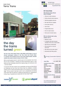 Melbourne Tram Museum
Pamphlet, Energy Conservation Systems, "Case Study Yarra Trams", May. 2005
... Published by Energy Conservation Systems. Water saving systems etc. Two copies held....Published by Energy Conservation Systems. Water saving systems etc. Two copies held. ...Pamphlet - A4 full colour printed on white paper, titled "Case Study Yarra Trams" with sub-title "the day the trams turned green" about the installation of environmental friendly installations at East Preston Depot, solar panels, part of the Green Depot project, May 2005. Published by Energy Conservation Systems. Water saving systems etc. Two copies held.trams, tramways, yarra trams, east preston depot -
 Wodonga & District Historical Society Inc
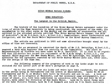
Album - Hume Reservoir Australia Album - Introduction - Part 1, Department of Public Works, N.S.W, 1927
... Dare, M.E., M.Inst.C.E., Commissioner, Water Conservation and Irrigation, and the New South Wales Representative on the River Murray Commission. ...Dare, M.E., M.Inst.C.E., Commissioner, Water Conservation and Irrigation, and the New South Wales Representative on the River Murray Commission. ...This set of photos is from a leather bound album bearing the inscription "HUME RESERVOIR AUSTRALIA" plus 'The Rt. Hon. L. C. M. S. Amery, P. C., M .P.' all inscribed in gold. It was presented to The Rt. Hon. L. C. M. S. Amery, P. C., M. P, Secretary of State for Dominion Affairs on the occasion of his visit to the Hume Reservoir on 2nd November 1927. This album is of local and national significance as it documents the planning and development of the Hume Reservoir up to 1927. It was the largest water reservoir in the British Empire. The album records the pioneering engineering work that went into its construction.RIVER MURRAY WATERS SCHEME, HUME RESERVOIR THE LARGEST IN THE BRITISH EMPIRE. ' The history of the inception of the River Murray Waters Agreement under the terms of which the Hume Reservoir is being constructed, the purposes of the work, its correlation to the other works on the Murray and the methods of construction are all outlined in the attached article entitled “The River Murray Waters Scheme, the Nile of Australia”, by Mr H.H. Dare, M.E., M.Inst.C.E., Commissioner, Water Conservation and Irrigation, and the New South Wales Representative on the River Murray Commission. The article was published in 1925 and some alterations brought about by the efflux of time are necessary. As far as personnel is concerned, the death of Mr J.S. Dethridge, M.Inst.C.E., removed a very able engineer from the councils of the Commission. His place as Representative of Victoria has been taken by Mr R. Horsfield. It is also to be regretted that ill-health has caused the retirement of Mr E.M. de Burgh, M.Inst.C.E., the eminent Chief Engineer for New South Wales, who, with Mr Dethridge, was largely responsible for the Agreement cemented by the River Murray Waters Acts and, inter alia, for the design of the Hume Dam. The following summary of the progress of work on the Locks might be substituted for the latter part of Mr Dare’s paragraph. Up to the present time six locks and weirs have been completed, the highest in the series being at Torrumberry and the lowest at Blanchetown. Locks No.26 at Torrumberry and No.11 at Mildura were built by Victoria and are in use. A lock and weir (No.10) is in progress at Wentworth, and the necessary camp arrangements, purchase of plant, etc., have been undertaken in connection with lock and weir No.15 at Euston, both under the direction of New South Wales. Lock No.9, which forms part of the Lake Victoria Scheme, Lock No.5 at Renmark and Lock No.3 in South Australia hume reservoir australia, river murray waters scheme -
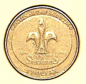 Sunshine and District Historical Society Incorporated
Coin - Australian One Dollar Coin - Centenary of Australia Scouting 2008
... . - Survival Skills: Shelter building, fire lighting, and water purification. - Nature Conservation: Tree planting, wildlife monitoring, and clean-up projects. - First Aid: Emergency response and safety training. - Cooking: Campfire meals, bush cooking, and nutrition. - Crafts & DIY: Knot tying, woodwork, leatherwork, and badge-making. - STEM Projects: Robotics, coding, and environmental science. - Drama & Performance: Skits, storytelling, and talent shows. - Music & Dance: Campfire songs, cultural dances, and instrument practice. - Art & Design: Poster-making, painting, and costume creation. - Service Projects: Volunteering, fundraising, and helping local causes. - Leadership Training: Patrol leader roles, mentoring, and public speaking. - Cultural Exchange: International pen pals, travel, and global awareness. - Badge Work: Earning merit badges in areas like fitness, communication, and innovation. - Team Challenges: Problem-solving games and cooperative tasks. - Reflection & Journaling: Personal growth and goal setting. - Environmental Advocacy: Sustainability campaigns and eco-challenges..... - Survival Skills: Shelter building, fire lighting, and water purification. - Nature Conservation: Tree planting, wildlife monitoring, and clean-up projects. - First Aid: Emergency response and safety training. - Cooking: Campfire meals, bush cooking, and nutrition. - Crafts & DIY: Knot tying, woodwork, leatherwork, and badge-making. - STEM Projects: Robotics, coding, and environmental science. - Drama & Performance: Skits, storytelling, and talent shows. - Music & Dance: Campfire songs, cultural dances, and instrument practice. - Art & Design: Poster-making, painting, and costume creation. - Service Projects: Volunteering, fundraising, and helping local causes. - Leadership Training: Patrol leader roles, mentoring, and public speaking. - Cultural Exchange: International pen pals, travel, and global awareness. - Badge Work: Earning merit badges in areas like fitness, communication, and innovation. - Team Challenges: Problem-solving games and cooperative tasks. - Reflection & Journaling: Personal growth and goal setting. - Environmental Advocacy: Sustainability campaigns and eco-challenges. ...Over the years, Australia has issued numerous commemorative $2 coins, often featuring vibrant colors and themes honoring national events, heroes, and cultural milestones. This coin was issued in 2008 to celebrate the centenary of Scouting in Australia. Sunshine Scouts & Cubs are part of the global youth movement that empowers young people to become responsible, active citizens through adventure, education, and service. It fosters character development, leadership, and community engagement across cultures and continents. Activities include: - Camping: From weekend bush camps to international jamborees. - Hiking & Orienteering: Map reading, compass skills, and trail navigation. - Survival Skills: Shelter building, fire lighting, and water purification. - Nature Conservation: Tree planting, wildlife monitoring, and clean-up projects. - First Aid: Emergency response and safety training. - Cooking: Campfire meals, bush cooking, and nutrition. - Crafts & DIY: Knot tying, woodwork, leatherwork, and badge-making. - STEM Projects: Robotics, coding, and environmental science. - Drama & Performance: Skits, storytelling, and talent shows. - Music & Dance: Campfire songs, cultural dances, and instrument practice. - Art & Design: Poster-making, painting, and costume creation. - Service Projects: Volunteering, fundraising, and helping local causes. - Leadership Training: Patrol leader roles, mentoring, and public speaking. - Cultural Exchange: International pen pals, travel, and global awareness. - Badge Work: Earning merit badges in areas like fitness, communication, and innovation. - Team Challenges: Problem-solving games and cooperative tasks. - Reflection & Journaling: Personal growth and goal setting. - Environmental Advocacy: Sustainability campaigns and eco-challenges.Australian One Dollar Coin. The obverse side features the portrait of Queen Elizabeth II. The reverse side features the international symbol for scouting, the fleur-de-lis representing the compass which symbolizes the three promises made by all scouts and cubs throughout the world.Obverse Side - Elizabeth II Australia 2008 Reverse Side - Centenary of Scoting 1908 - 2008 Scouts Australia One Dollarscouting, scouts -
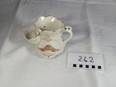 Blacksmith's Cottage and Forge
Mug, Shaving
... When needed, one can take the brush and brush it against the soap, bringing up a layer of lather; excess water is drained back. This allows conservation of water and soap, whilst retaining enough heat to ensure a long shave. ...When needed, one can take the brush and brush it against the soap, bringing up a layer of lather; excess water is drained back. This allows conservation of water and soap, whilst retaining enough heat to ensure a long shave. ...A shaving scuttle and shaving mug were developed around the 19th century with the first patent for a shaving mug dating to 1867.[8] As hot water was not common in many households, one way to provide hot lather was to use a scuttle or mug. A traditional scuttle resembles a teapot with a wide spout where hot water is poured in, and this is where it differs from a shaving mug, which has no spout. Both shaving scuttles and mugs usually have a handle, but some have none. Shaving mugs often look like a standard mug, however, some also have a built in brush rest, so the brush does not sit in lather. Modern versions of the scuttle are in limited production, usually by independent potters working in small volumes.[9] At the top of the scuttle or mug is a soap holder. Traditionally, it was used with a hard block of shaving soap (rather than soft soap or cream) and therefore had drain holes at the bottom. Later scuttles and mugs do not include the holes, and thus can be used with creams and soft soaps. Some scuttles and mugs have concentric circles on the bottom, which retain some water thus helping to build lather.[9] In use, the shaving brush is dunked into the wide spout, allowing it to soak into the water and heat up. The soap is placed in the soap holder. When needed, one can take the brush and brush it against the soap, bringing up a layer of lather; excess water is drained back. This allows conservation of water and soap, whilst retaining enough heat to ensure a long shave. Source: www.wikipedia.org Local social historyOrnate white china mug with handle. Cup side to hold brush and saucer shaped top with 3 drainage holes. Gold painted decoration and flower garland of pink and yellow roses. Mother of pearl effect over sides.Made in Germanyshaving, item, china, mug, bathroom, men, personal, toiletry -
 Eltham District Historical Society Inc
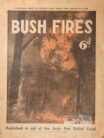
Magazine, Sun News-Pictorial, Bush Fires: A pictorial survey of Victoria's most tragic week, January 8-15, 1939, 1939
... Forest damage totals at least a million pounds, and incalculable damage has been done to the seedlings which were to have been the forests of the future. Water conservation will be seriously affected by the silting-up of reservoirs and streams from which protective timber has been taken by the all-engulfing flames. ...Forest damage totals at least a million pounds, and incalculable damage has been done to the seedlings which were to have been the forests of the future. Water conservation will be seriously affected by the silting-up of reservoirs and streams from which protective timber has been taken by the all-engulfing flames. ...THE WEEK REVIEWED (Article; Bush Fires: A pictorial survey of Victoria's most tragic week, January 8-15, 1939. Published in aid of the Bush Fire Relief Fund by the Sun News-Pictorial in co-operation with its newsagents, pp2-3) THE fiercest bush fires Australia has known since its discovery are quiescent at the moment, and Victoria, in the comparative coolness of the change which came with rain on Sunday night, has begun·to count its losses. In the fiery eight days, from Sunday to Sunday, at least sixty-six men, women and children have lost their lives in forest fires, or have succumbed to burns and shock; many others have died from heat; and several serious cases of burns are being treated in hospitals. Two babies in Narrandera district have died, and ten others are in hospital, because of milk soured by the record temperatures of those eight days. Forest damage totals at least a million pounds, and incalculable damage has been done to the seedlings which were to have been the forests of the future. Water conservation will be seriously affected by the silting-up of reservoirs and streams from which protective timber has been taken by the all-engulfing flames. More than a thousand houses have been destroyed, and these, with 40 mills, and schools, post-offices, churches, and other buildings, represent a loss of at least half a million. At least 1500 are homeless. For their aid, money raised in appeals has now passed the £50,000 mark, and the biggest relief organisation ever set up in peace time has swung into operation. The First Hint Victoria's first hint of what was to come appeared on Sunday, January 8, when most parts of the State awoke to find a blistering day awaiting. At 12.20 p.m., when the thermometer reached its highest for the day, 109.6 degrees, the first fire victims were at that moment going to their death on a bush track five feet wide off the main road to Narbethong. They were the forestry officers Charles Isaac Demby and John Hartley Barling, who went to warn Demby of his danger when he parted from his companions, and was himself surrounded by the treacherous fire. It was not until 8 o'clock next morning that the tragic news was flashed throughout the State. Searchers found the two charred bodies close together, one seeking protection in the nook of two logs. Barling's watch had stopped at 1.20. In the meantime, tragedy was spreading its cloak. By Monday, big fires were raging at Toolangi, Erica, Yallourn, Monbulk, Frankston, Dromana, Drouin South, Glenburn, and Blackwood, with smaller outbreaks at many other centres. In the ensuing week, while women and children were evacuated as fast as the flames would permit, Erica-scene of the 1926 fire disaster-thrice escaped doom by a change of wind. Indeed, those who have been in the fire country these past days say that the numbers of times a change of wind has saved towns from destruction is amazing. In the towns they speak of miracles. Monday's Miracles The escapes from Monett's Mill at Erica and from the Hardwood Company's Mill at Murrindindi, near where Demby and Barling went to their death, were Monday's miracles. Twenty came out alive from each mill. At the first a 60ft. dugout provided an oven-like refuge; at the second, 12 women and children survived in the smoke-filled gloom of a three-roomed cottage while their eight men, their clothes sometimes afire, poured water on the wooden walls. Three houses out of ten remained when the fire had passed. Record Temperatures Sunday had been the hottest Melbourne day for 33 years; Monday dropped to a 76.1 degree maximum; but Tuesday dawned hotter than ever, the mercury reaching 112.5. By now rumor was racing ahead of fact; whole towns were being reported lost; the alarm was raised for scores of missing persons. But fact soon overtook rumor, and within a few days the staggering toll began to mount to a figure beyond the wildest imaginings of the panic-stricken. Six died from heat on this torrid Tuesday, and the fires spread in a wide swathe from south-west to north-east across the State. Fish died in shallow streams. A curtain of smoke hid the sky from all Victoria, and hung far out to sea. It alarmed passengers on ships. On the Ormonde, on the voyage to Sydney from Burnie, women ran on deck, believing fire had broken out in the hold. Days later the smoke reached New Zealand. In Melbourne thousands of fire-volunteers were leaving in cars: vans, motor-buses-anything reliable on wheels-to aid the country in its grim fight. In the fires at Rubicon and. Narbethong, seventeen were facing death this day. But not till Wednesday, when Melbourne breathed again in a cool change, while the country still sweltered in temperatures up to 117 degrees, did the news come through the tree blocked roads. A woman and her little daughter, trapped on the road, were among those who died. Their bodies, and those of menfolk with them, were found strewn out at intervals along the road, where the furnace of the surrounding fire had dropped them in their tracks as they ran. Twelve died at a Rubicon mill, five on the road at Narbethong. At Alexandra, not far distant, a baby was born while the fires raged, and stretcher-bearers brought in the injured. On Thursday the State Government voted £5000 for the relief of fire victims. The Governor (Lord Huntingfield) and the Lord Mayor (Cr. Coles) visited some of the stricken areas, and dipped into their pockets personally. Later, the City Council, too, voted £5000. Friday, The 13th Friday, the Thirteenth, justified its evil name. A blistering northerly came early in the morning, presaging destruction, and forcing the mercury to a new record of 114 degrees. Racing fires killed at least ten in those terrible 12 hours. Four children were engulfed in the furnace at Colac. Panic drove them, uncontrollable, into the smoke-filled road when the fire raced down behind their home. They choked to death. In other parts fires were joining to make fronts of scores of miles. Kinglake was being menaced on two fronts, £60,000 worth of timber was going up in smoke in Ballarat district. Warburton was surrounded. Residents at Lorne, favoured resort, were being driven to the sea-front by a fire which destroyed at least 20 homes. Healewille. with flames visible from the town at one stage, was in a trough between two fires which burned four guest-houses, seven homes and left its surrounding beauty-spots wastes of bowed-over, blackened tree-fern fronds; with its famous Sanctuary, however, intact. Most of Omeo was destroyed this black day: Noojee. while 200 residents crouched in the river, was being reduced to a waste of buckled iron and smoking timber; Erica was once again saved by a change of wind. Beneath a pall of smoke, the Rubicon victims were buried at Alexandra. Friday night and the early hours of Saturday saw the streets of beleagured towns strewn with exhausted fire-fighters. Their flails beside them, ready for the next call, they lay where exhaustion overtook them-on footpaths, beside lamp-posts, in gutters, in cars, under trucks. Saturday's dawn brought clear skies and lower temperatures in many parts, and from the burnt-out areas came a great rush of tragic reports. The death-roll rushed past the fifty mark with incredible speed. Some had been trapped on roads, others at mills; some, after burying their treasures, had clung too long to the places they had made their homes for many years. Four men lost their lives because one went back for his dog. By Sunday, when the first of the saving rain came, nearly another score of names had been added to the list.Newspaper magazine, 48 pages (incl. covers). Fully digitised and searchable PDFPublished in aid of the Bush Fire Relief Fund by the Sun News-Pictorial in co-operation with its newsagents.bushfires, 1939 bushfires, black friday, warrandyte -
 Warrnambool and District Historical Society Inc.
Document - Map, Soil conservation authority:plan of high water marks at Lady Bay Warrnambool, 1984
... Soil conservation authority:plan of high water marks at Lady Bay Warrnambool. ...In lower RH corner Soil conservation AuthorityPlan of High water marks at Lady Bay Warrnambool. ...Soil conservation authority:plan of high water marks at Lady Bay Warrnambool. ...This map documents the changing state of Lady Bay from around 1870 until 1976. It depicts the changing high water mark over that period and the main outlet of the Merri River in 1872 and 1976.This map provides a useful and significant insight into the ever changing face of Lady Bay from the 1870’s through to 1980’s. Cream paper map drawn with black ink showing Lady Bay and South Warrnambool section of Warrnambool. In lower RH corner Soil conservation AuthorityPlan of High water marks at Lady Bay Warrnambool. Drawn P.D. 19.1/84. Scale 1:3600. Written on back in black pencil: Lady Bay Historical HWM lady bay map, merri river 1872- 1976, merri river 1872- 1976, history of warrnambool -
 Kiewa Valley Historical Society
Report - Alpine Study Area Volume 2 Maps, Land Conservation Council, 1970s
... Conservation Council. Maps include 1. Public land and descriptive blocks. 2. Physiography. 3. Topography. 4. Geology (missing). 5. Rainfall and water...Conservation Act 1970. These maps provide an assessment of the Alpine area at the time the maps were created. Some of the topics eg. Rainfall and water ...The Victorian Environmental Assessment Council and the former Environment Conservation Council (ECC) and Land Conservation Council (LCC) have completed 36 land use investigations over more than 35 years, including 27 regional reviews. They provide a framework for use of Public Land in Victoria. The Land Conservation Council was established by the Land Conservation Act 1970.These maps provide an assessment of the Alpine area at the time the maps were created. Some of the topics eg. Rainfall and water resources may change over the years thus providing a comparative analysis. Others may provide information for future development such as mineral exploration, building of a dam / tunnel etc.Blue box shaped folder containing 9 of 10 Maps of the Alpine Study Area produced by the Land Conservation Council. Maps include 1. Public land and descriptive blocks. 2. Physiography. 3. Topography. 4. Geology (missing). 5. Rainfall and water resources. 6. Vegetation 7. Land systems. 8. Recreation. 9. Primary production. 10. Minerals Ex library item. Stamped in red "Discarded From Stock / Swan Hill Regional Libraryalpine area, maps of alpine area, land conservation council -
 Kiewa Valley Historical Society
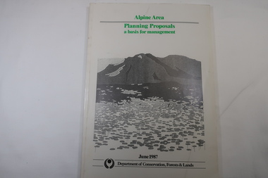
Book - Book - Alpine Area - Department of Conservation, Forests & Lands, Alpine Area / Planning Proposals / a basis for management. 1987
... water catchment. This country is at the upper end of the Kiewa Valley and the planning for it is of interest to the Kiewa Valley inhabitants. Alpine Area Bogong National Park Victorian Department of Conservation Forests & Lands White bound book with green print for title at the top, black & white picture and black print at the bottom for the name of the government authority publishing the book.143 pages with fold out map after page 7. ...It is the policy of the Government that most of the State's alpine area will be proclaimed as an Alpine National Park, which would complement the Kosciusko National Park in N.S.W.. This is yet to be achieved (1987), however there is a need for sound, efficient and coordinated management based on the area's natural features, values and uses. Planning is proceeding on this basis.Victoria's alpine area is one of the State's most outstanding and spectacular natural areas. It is noted for its diverse plant and animal life, scenery, recreation opportunities and as a water catchment. This country is at the upper end of the Kiewa Valley and the planning for it is of interest to the Kiewa Valley inhabitants.White bound book with green print for title at the top, black & white picture and black print at the bottom for the name of the government authority publishing the book.143 pages with fold out map after page 7. The map is coloured green to indicate the planning area.alpine area, bogong national park, victorian department of conservation forests & lands -
Federation University Historical Collection
Report, Read Sturgess and Associates Consulting Economists et al, The Economic Significance of Grampians National Park, 1994 (and other reports), 1990-4
... Barker Library (top floor) Mount Helen goldfields victorian tourisim industry tourism halls gap grampians grampians national park recreation water production bee keeping arapiles dunkeld balmoral pomonal wartook population agriculture water supplies minerals hamilton ararat stawell horsham wimmera koorie heritage aboriginal heritage koorie art sites brambuk waterways wannon river wimmera river mount william creek rocklands reservoir lake lonsdale lake fyans lake toolando cherrypool mirranatwa zumstein Notes in pencil by Mary Hollick, lecturer in Tourism at the University of Ballarat. .1) Grampians Surround Strategy, 1990 .2) Tourism and the Grampians Region: A Background Paper, 1990 .3) Grampians Surround Strategy and Discussion Paper, 1991 .4) The Economic Significance of Grampians National Park for the Department of Conservation and Natural Resources, 1994 The Economic Significance of Grampians National Park, 1994 (and other reports) Report Read Sturgess and Associates Consulting Economists Trevor Budge and Associates Victorian Tourism Commission Hassell Planning Consultants ....1) Grampians Surround Strategy, 1990 .2) Tourism and the Grampians Region: A Background Paper, 1990 .3) Grampians Surround Strategy and Discussion Paper, 1991 .4) The Economic Significance of Grampians National Park for the Department of Conservation and Natural Resources, 1994Notes in pencil by Mary Hollick, lecturer in Tourism at the University of Ballarat.victorian tourisim industry, tourism, halls gap, grampians, grampians national park, recreation, water production, bee keeping, arapiles, dunkeld, balmoral, pomonal, wartook, population, agriculture, water supplies, minerals, hamilton, ararat, stawell, horsham, wimmera, koorie heritage, aboriginal heritage, koorie art sites, brambuk, waterways, wannon river, wimmera river, mount william creek, rocklands reservoir, lake lonsdale, lake fyans, lake toolando, cherrypool, mirranatwa, zumstein